Geology of the Comstock-Indian Wells Area of the Comstock-Indian Wells Area Val Verde, Terrell, and...
34
Geology of the Comstock-Indian Wells Area Val Verde, Terrell, and Brewster Counties, Texas GEOLOGICAL SURVEY PROFESSIONAL PAPER 594-K
-
Upload
nguyentuyen -
Category
Documents
-
view
215 -
download
0
Transcript of Geology of the Comstock-Indian Wells Area of the Comstock-Indian Wells Area Val Verde, Terrell, and...
Geology of the
Comstock-Indian Wells Area
Val Verde, Terrell, and
Brewster Counties, Texas
GEOLOGICAL SURVEY PROFESSIONAL PAPER 594-K

Geology of the
Comstock-Indian Wells Area
Val Verde, Terrell, and
Brewster Counties, Texas By VAL L. FREEMAN
SHORTER CONTRIBUTIONS TO GENERAL GEOLOGY
GEOLOGICAL SURVEY PROFESSIONAL PAPER 594-K
A description of the petrography and structure of the sedimentary rocks along the Rio Grande in the vicinity of the mouth
of the Pecos River
UNITED STATES GOVERNMENT PRINTING OFFICE, WASHINGTON : 1968

UNITED STATES DEPARTMENT OF THE INTERIOR
STEWART L. UDALL, Secretary
GEOLOGICAL SURVEY
William T. Pecora, Director
For sale by the Superintendent of Documents, U.S. Government Printing Office Washington, D.C. 20402
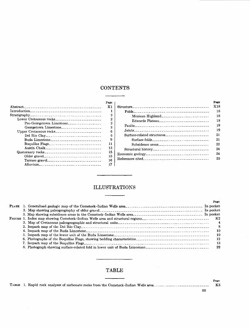
CONTENTS
Abstract __________________________________________ _ Introduction ______________________________________ _ Stratigraphy ______________________________________ _
Lower Cretaceous rocks ________________________ _ Pre-Georgetown Limestone _________________ _ Georgetown Limestone _____________________ _
Upper Cretaceous rocks ________________________ _ Del Rio Clay ______________________________ _ Buda Limestone ___________________________ _ Boq uillas Flags ____________________________ _ Austin Chalk ______________________________ _
Qua ternary rocks ______________________________ _ Older graveL ______________________________ _ Terrace graveL ____________________________ _ Alluvium _________________________________ _
Page
K1 1 2 2 2 3 6 6 9
11 13 15 15 16 17
Structure _________________________________________ _ Folds _________________________________________ _
Mexican Highland _________________________ _
Edwards Plateau ____________________ -------Faults ________________________________________ _ Joints ________________________________________ _
Surface-related structures ___________ -- __________ _ Surface folds _________________ --_-_---------Subsidence areas _______________ - ____ ----_---
Structural history ______________________________ _
Economic geology ______________ -- __ -----------------References cited _______________________ - _________ -_-
ILLUSTRATIONS
Pag9
K18 18 18 18 19 19 21 21 22 24
24
25
Page
PLATE 1. Generalized geologic map of the Comstock-Indian Wells area __________________________________________ In pocket 2. Map showing paleogeography of older graveL _______________________________________________________ In pocket 3. Map showing subsidence areas in the Comstock-Indian Wells area __________________________________ --__ In pocket
FIGURE 1. Index map showing Comstock-Indian Wells area and structural regions_____________________________________ K2 2. Map of Cretaceous paleogeographic and structural units__________________________________________________ 4 3. Isopach map of the Del Rio Clay______________________________________________________________________ 8 4. Isopach map of the Buda Limestone____________________________________________________________________ 10 5. Isopach map of the lower unit of the Buda Limestone____________________________________________________ 10 6. Photographs of the Boquillas Flags, showing bedding characteristics________________________________________ 12 7. Isopach map of the Boquillas Flags_____________________________________________________________________ 13 8. Photograph showing surface-related fold in lower unit of Buda Limestone___________________________________ 22
TABLE
Page
TABLE 1. Rapid rock analyses of carbonate rocks from the Comstock-Indian Wells area______________________________ K5
Ill

SHORTER CONTRIBUTIONS TO GENERAL GEOLOGY
GEOLOGY OF THE COMSTOCK-INDIAN WELLS AREA, VAL VERDE, TERRELL, AND BREWSTER COUNTIES, TEXAS
By vAL L. FREEMAN
ABSTRACT
The Comstock-Indian Wells area, along the Rio Grande between lat 29°30' and 30° N. and long 101 °00' W. and 102°30' W., includ·es parts of Val Verde, Terrell, and Brewster Counties in West Texas. The rocks mapped and described in this study include two units of Early Cretaceous age, four formations of Late Cretaceous age, and four units of Quaternary age. The Cretaceous rocks are dominantly marine limestones that were successively deposited in a shallow shelf environment. Limestone deposition was interrupted for a time during the early Late Cretaceous by an influx of clay and silt, followed by growth of a short-lived arch in the central part of the area. Post-Cretaceous rocks are stream deposits, mostly gravels, now exposed as ridge caps, terrace remnants, and alluvium.
Structurally, the area was affected by the folding and accompanying faulting of the Mexican Highland. to the west. and by the uplift and warping of the Edwards Plateau. Joints in the rocks were studied by plotting all those visible in selected areas, by mapping joint-controlled lineaments visible on aerial photographs, and by plotting joint-controlled straight stream segments in selected areas. It was found that joints formed at several times and with diverse trends. During uplift, the latest structural movement in the area, the northeast-trending joints were opened.
Subsidence areas of unusual size and number are attributed to solution at depth accompanied and followed by collapse of the overlying rocks by downwarping, faulting, and brecciation.
Mineral resources have been of very minor importance to the economy of the area, although use has been made of rock suitable for road and railroad materials, of rock suitable for building stone, and of deposits of bat guano and manganese. None of the mineral resources of the area seem adequate for steady production under present economic conditions.
INTRODUCTION
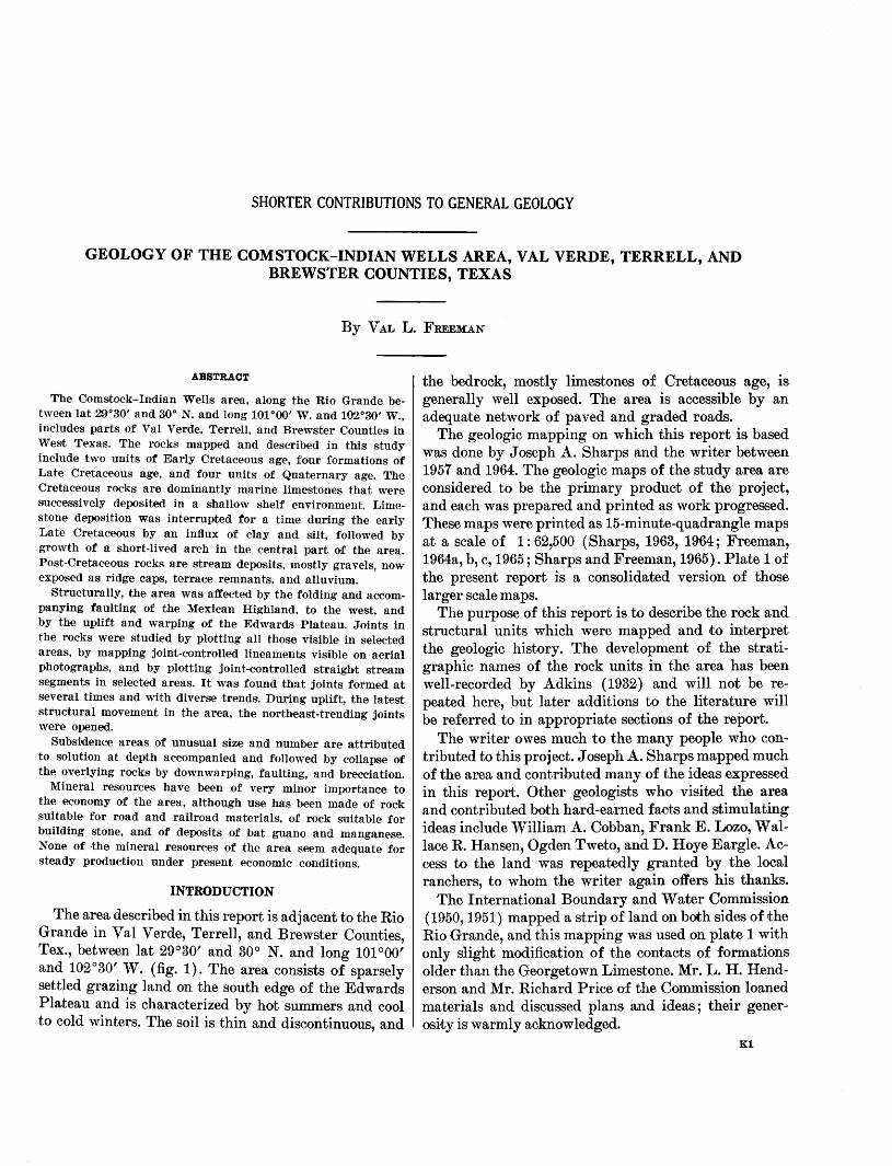
The area described in this report is adjacent to the Rio Grande in Val Verde, Terrell, and Brewster Counties, Tex., between lat 29°30' and 30° N. and long 101 °00' and 102°30' W. (fig. 1). The area consists of sparsely settled grazing land on the south edge of the Edwards Plateau and is characterized by hot summers and cool to cold winters. The soil is thin and discontinuous, and
the bedrock, mostly limestones of Cretaceous age, is generally well exposed. The area is accessible by an adequate network of paved and graded roads.
The geologic mapping on which this report is based was done by Joseph A. Sharps and the writer between 1957 and 1964. The geologic maps of the study area are considered to be the primary product of the project, and each was prepared and printed as work progressed. These maps were printed as 15-minute-quadrangle maps at a scale of 1 : 62,500 (Sharps, 1963, 1964; Freeman, 1964a, b, c, 1965; Sharps and Freeman, 1965). Plate 1 of the present report is a consolidated version of those larger scale rna ps.
The purpose of this report is to describe the rock and structural units which were mapped and to interpret the geologic history. The development of the stratigraphic names of the rock units in the area has been well-recorded by Adkins ( 1932) and will not be repeated here, but later additions to the literature will be referred to in appropriate sections of the report.
The writer owes much to the many people who contributed to this project. Joseph A. Sharps mapped much of the area and contributed many of the ideas expressed in this report. Other geologists who visited the area and contributed both hard-earned facts and stimulating ideas include William A. Cobban, Frank E. Lozo, Wallace R. Hansen, Ogden Tweto, and D. Hoye Eargle. Access to the land was repeatedly granted by the local ranchers, to whom the writer again offers his thanks.
The International Boundary and Water Commission (1950, 1951) mapped a strip of land on both sides of the Rio Grande, and this mapping was used on plate 1 with only slight modification of the contacts of formations older than the Georgetown Limestone. Mr. L. H. Henderson and Mr. Richard Price of the Commission loaned materials and discussed plans and ideas; their generosity is warmly acknowledged.
Kl
K2 SHORTE'R CONTRIBUTIONS TO GENERAL GEOLIOGY
102°
\ ,\ r;---' \ g,u
\ rn lj \8 ~ 12-
I
I I
I I , \~'~
MAR AT H 0 N""' r---D~ -------~2_CKETT _CO isuTTO! CO
0 Marathon """ I \ I
'" I 0\Sanderson .<;> I () VAL VERDE CO
u p L I F T '~ l I'
loo~\=e~l=N=orte~G=a~p~_,---------------'~~~----------~------~------~--~----------~----------1 300 \ /,{Indian Wens f /:)
\ ~ >~~ t \ /~/ Y .... , UNI D STATESJ
\ ....._,_l ""- '\ ... ..AI(,J ....(! 1"1 / Q .,-'\,.. MEXICO ~,, c.- V) \ / ~ ,.... ~ Comstock
() l~ / -?-v'f?"' /!'Y~ oo,4'>'\ I /c, J~ ..P/(\
tf.t I ~ 0' I ~~ 7,_£ .. 1\ ~~IC•AN }(; ~~ r r~ ~--l _ __.. I~ ~ ~,,
BIG BEND v 0 10 20 30 40 MILES 0
Del Rio
NATIONAL PARK
( ..,.(
"'..---._" GULF-1
COASTAL PLAIN
~~~,~~~~~~--~------------------------------~------------------------------~--------~29°
FIGURE 1.-Comstock-Indian Wells area (patterned) and structural regions.
STRATIGRAPHY
LOWER CRETACEOUS ROCKS
The Lower Cretaceous rocks of the mapped area are designated on plate 1 as pre-Georgetown Limestone and Georgetown Limestone. On the more detailed, larger scale maps (Sharps, 1963, 1964; Freeman, 1964a, b, c, 1965; Sharps and Freeman, 1965) the Lower Cretaceous was subdivided to conform to the units on the maps of the International Boundary and W ate.r Commission (1950, 1951) from which the. contacts below the Georgetown were taken with but slight modification. These preGeorgetown formations-the. Kiamichi( ?) Formation, Edwards Limestone, Comanche Peak Limestone, Walnut Clay, Maxon Limestone, and Glen Rose Limestone, in descending order-crop out in small areas where access is difficult, and therefore they were not studied in detail by the writer.
The Lower Cretaceous rocks of west Texas and adjoining Mexico were studied by Lozo and Smith (1964) of the Shell Development Co. They showed that the commonly used formational names are not compatible with the local sedimentary units within the series, and they proposed new names for the units in the southern part of the study area. However, because Lozo and Smith had not proposed new names for the northern part at the time of the present writing, and because the detailed maps are already in print, the names used in this report will correspond to those used on the detailed rna ps.
PRE-GEORGETOWN LIMESTONE
The oldest rocks exposed in the study area crop out along the Rio Grande west of Indian Creek. These preGeorgetown, Lower Cretaceous rocks are shown as a single unit on plate 1 but were subdivided into five map units by the geologists of the International Bounda,ry and Water Commission ( 1950, 1951; see also Sharps,
COMSTOCK-INDIAN WELLS AREA, TEXAS K3
1963, 1964; Freeman, 1964a). The thickest sequence of pre-Georgetown rocks exposed in the area is in the canyon of the Rio Grande about 10 river miles upstream from the mouth of San Francisco Creek, where the river has cut through a broad anticline. The oldest beds are limestone considered to be equivalent to the uppermost part of the Glen Rose Limestone.
The beds of Glen Rose age, which are poorly exposed and difficult to reach, were seen only from a distance. They are composed of gray-weathering limestone that crops out as a ledge over which the river flows, fonning small rapids. The upper part of the Glen Rose Limestone was described by Small (1949, p. 9) as consisting of "thin to moderately bedded, slightly crystalline, soft, nodular, dull gray limestone."
A group of beds shown as the Maxon Formation on the maps of the International Boundary and Water Commission (1950, 1951) and as the Maxon Limestone by Freeman ( 1964a) overlies the Glen Rose Limestone with probable conformity, although the contact itself was not seen. About 90 percent of the unit consists of medium-gray clayey limestone beds, but the unit is characterized by the 10 percent that consists of Inoderate-yellowish-brown silty or sandy limestone beds. The clayey limestone is mostly thin to thick bedded and weathers to nodules; it is fossiliferous, but the fossils are not easily collected from the matrix. Some beds have a splintery or conchoidal mode of fracturing, are without nodules, and seem to contain less clay. The silty or sandy limestone occurs in thick to very thick beds that \Yeather moderate yellowish brown, which is in distinct contrast to the medium gray of the limestones forming the rest of the canyon walls. Silt-sized to medium-sandsized grains of insoluble material compose about 5-50 percent of this limestone. A small amount of gypsum in large specks was identified with a hand lens. The Maxon Li1nestone is about 250 feet thick.
The next younger pre-Georgetown unit was mapped by the International Boundary and Water Commission (1950, 1951) and by Freeman (1964a) as Walnut Clay and Comanche Peak Limestone. The propriety of this usage was discussed by Lozo and Smith ( 1964, p. 290) . The unit consists of medium-gray nodular-weathering clayey limestone beds in which bedding planes are difficult to see. Fossils are very common, and some beds might better be described as a lime-mud coquina. The unit lies conformably upon the uppermost sanely limestone referred to the Maxon and beneath the thick limestone referred to the Eel wards Limestone. Locally the upper part of this unit is seen in the lower part of a vertical cliff cut into the more resistant Edwards Limestone, and in such places the lack of distinct bedding is the readily distinguishing feature. The thickness of the
Walnut Clay and Comanche Peak Limestone is about 60 feet.
The striking feature of the pre-Georgetown rocks in the canyon of the Rio Grande is the line of cliffs cut into the rocks considered to be Edwards Limestone (International Boundary and Water Commission, 1950, 1951; Freeman, 1964a). About 400 feet above the base of the cliffs is a steep slope above which rises another 300-400 feet of limestone cliff. Only the limestone below the steep slope is rna ppecl as Ed wards Limestone. The limestone above the steep slope is mapped as Georgetown Limestone. The limestone beds forming the steep slope (about 50 ft. thick) are 1na ppecl as Kiamichi ( ?) Formation.
The Edwards Limestone rests conformably upon the Comanche Peak Limestone; the contact is gradational. The Edwards lacks the nodular appearance of lower beds and probably has a lesser clay content. It is composed of medium-gray thin- to thick-bedded fossiliferous limestone and dolomitic limestone that is so recrystallized that most of the original texture is destroyed. Chert occurs sparsely :as repl3!00cl fossils and as nodules.
Overlying the Edwards Limestone is a section of clayey limestone beds called l{iamichi Formation by the International Boundary and Water Commission (1950, 1951) and Kiamichi ( ? ) Formation by Freeman ( 1964a) and Sharps ( 1963, 1964) . These probably are the basal beds of a new cycle of deposition (F. E. Lozo, oral commun., 1962). The clayey limestones, here called the Kiamichi ( ? ) Formation, are not as well exposed as the overlying and underlying limestones, for they are more easily weathered and form a steep slope mostly covered with debris. They are medium gray, very finely crystalline or aphanitic, fossiliferous, fetid, nodular weathering, and thin bedded.
GEORGETOWN LIMESTONE
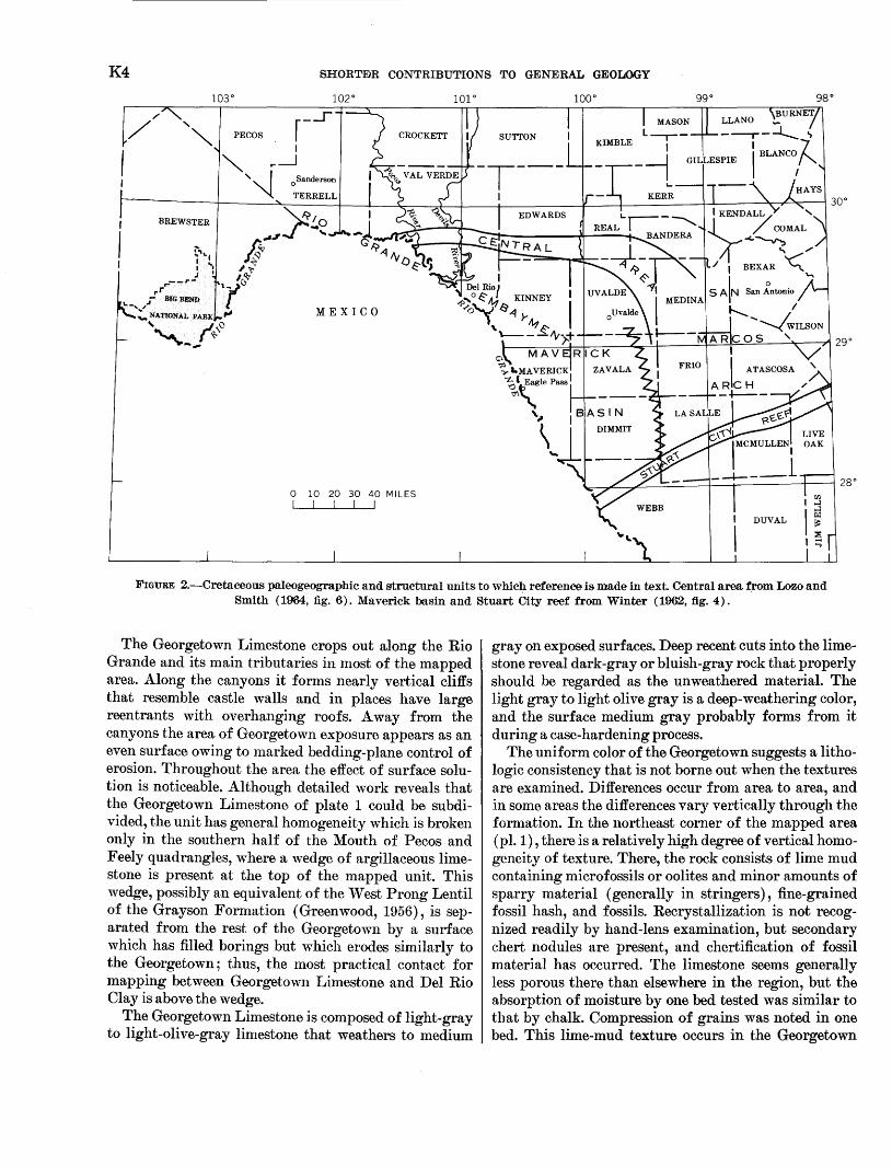
The Georgetown Limestone (pl. 1) , the most widely exposed formation in the mapped area, conformably overlies the l{iamichi ( ? ) Formation. Lozo and Smith ( 1964) recognized a "central 1area" in west TeX'as, east of Langtry and north of the Maverick basin (fig. 2) , wherein the interval between the Glen Rose Limestone and the Del Rio Clay is undiviclable. This unit they termed the Devils River Formation. North of this central area the rocks have not been formally na1necl, but in the Maverick basin Lozo and Smith proposed the name Salmon Peak Formation for rocks called the Georgetown Li1nestone in this report. On plate 1, their "central area" would lie between Langtry and the mouth of the Pecos River and extend ea1st to and beyond the map edge. The results of their work west of Langtry have not been published.
K4 SHORTE'R CONTRIBUTIONS TO GENERAL GEOOOGY
ggo ggo
PECOS I
"' ,__j ''" I 0 Sanderson
""'l TERRELL
0 10 20 30 40 MILES I I I I I WEBB
FIGURE 2.-Cretaceous paleogeographic and structural units to whicJ:l reference is made in text. Central area from Lozo and Smith ( 1964, fig. 6). Maverick basin and Stuart City reef from Winter ( 1962, fig. 4).
The Georgetown Limestone crops out along the Rio Grande and its main tributaries in most of the mapped area. Along the canyons it forms nearly vertical cliffs that resemble castle walls and in places have large reentrants with overhanging roofs. A way from the canyons the area of Georgetown exposure appears as an even surface owing to marked bedding-plane control of erosion. Throughout the area the effect of surface solut] on is noticeable. Although detailed work reveals that the Georgetown Limestone of plate 1 could be subdivided, the unit has general homogeneity which is broken only in the southern half of the Mouth of Pecos and Feely quadrangles, where a wedge of argillaceous limestone is present at the top of the mapped unit. This wedge, possibly an equivalent of the West Prong Lentil of the Grayson Formation (Greenwood, 1956), is separated from the rest of the Georgetown by a surface which has filled borings but which erodes similarly to the Georgetown; thus, the most practical contact for mapping between Georgetown Limestone and Del Rio Clay is above the wedge.
The Georgetown Limestone is composed of light-gray to light-olive-gray limestone that weathers to medium
gray on exposed surfaces. Deep recent cuts into the lime· stone reveal dark-gray or bluish-gray rock that properly should be regarded as the unweathered material. The light gray to light olive gray is a deep-weathering color, and the surface medium gray probably forms from it during a case-hardening process.
The uniform color of the Georgetown suggests a lithologic consistency that is not borne out when the textures are examined. Differences occur from area to area, and in some areas the differences vary vertically through the formation. In the northeast corner of the mapped area (pl. 1), there is a relatively high degree of vertical homogeneity of texture. There, the rock consists of lime mud containing microfossils or oolites and minor amounts of sparry material (generally in stringers), fine-grained fossil hash, and fossils. Recrystallization is not recog· nized readily by hand-lens examination, but secondary chert nodules are present, and chertification of fossil material has occurred. The limestone seems generally less porous there than elsewhere in the region, but the absorption of moisture by one bed tested was similar to that by chalk. Compression of grains was noted in one bed. This lime-mud texture occurs in the Georgetown
COMSTOCK-INDIAN WELLS AREA, TEXAS K5
elsewhere, but not as conspicuously as other textures. In the upper part of the formation throughout most of the area, beds of clayey lime mudstone are less resistant to weathering, and they contrast sharply with the purer lime mudstone. In the western part of the area, many beds contain abundant rudistid remains. In many places the fossil debris forms a framework-type texture with many pores and partial fillings of lime mud and of the smaller fragments of fossils. Such a rudistid limestone is prominent in Langtry, on the road to the International Discharge Cable (shown on the Langtry quadrangle map). A recrystallized texture is particularly common at the west edge of the mapped area. There, the original textures are mostly destroyed except for fossils replaced by chert. Reddish -orange chert occurs as thin ledges along bedding planes and as layers of nodules. Dolomite, mostly as subhedral grains, is seen in thin sections as a replacement of the original limestone. Recrystallization not accompanied by dolomite replacement was observed in beds at the U.S. Highway 90 bridge over the Pecos River.
Mineralogically and chemically the Georgetown Limestone, below the upper clayey beds, is rather pure limestone (table 1). Only secondary dolomite and chert are locally present in large quantities. Sparse yellowstained very fine quartz grains are the principal insoluble residues, and these probably account for the quartz detected by Hughes, ·Bradley, and Glass (1960).
Beds in the Georgetown are typically very thick, but thin beds also occur, especially near the top of the unit. The bedding planes appear to be regular and smooth from a distance but on close examination are seen to have small-scale irregularities mostly due to weathering. The bedding is mainly accentuated by reentrants but also showns as color bands. Crossbedding was seen at only one locality- in Mile Canyon near Langtry, where a low-angle crossbed is within a very thick bed in the upper part of the Georgetown.
The Georgetown Limestone as mapped in the western part of the area . (Sharps, 1963, 1964; Freeman, 1964a) is 450-600 feet thick.
The recent work of Winter (1961) and of Lozo and Smith (1964) gives a picture of the paleogeography of the Georgetown Limestone. The Georgetown of the southern part of the mapped area, the Salmon Peak of Lozo and Smith, can be considered as a lagoonal deposit that is bordered on the north by a reef deposit, the Devils River Formation of Lozo and Smith (underlying their "central area," fig. 2). North of the reef, in a region including the northern part of the mapped area, lay a shallow shelf that received lime deposits and periodic influxes of clay probably derived from the shore to the north and east. At the latitude of Fort Stockton, some 60 miles north of the mapped area, the marly units make it possible to subdivide the Georgetown into five members (Adkins, 1927).
Throughout most of the mapped area the Georgetown Limestone is truncated by an erosion surface; however, south of the middle of the Feely and Mouth of Pecos quadrangles, a wedge of clayey limestone above the erosion surface is shown on plate 1 as Georgetown. This wedge of rock may be an equivalent of the West Prong lentil of Grayson Shale defined by Greenwood (1956, p. 169) east of the mapped area as: "overlying the Georgetown limestone, with apparent conformity and sharp lithologic break, is a yellowish-brown, poorly indurated argillaceous limestone with thin clay partings."
The pinchout of this wedge of rock extends eastward across the middle of the Feely quadrangle; at the south edge of the quadrangle, the wedge is as much as 11 feet thick. 'rhe wedge in the mapped area is composed of thin beds nodular-weathering clayey limestone, limestone, and limy mudstone. The common fossil is Kingena. Glauconite grains were noted locally in beds where the weathering is less nodular and more slabby.
TABLE 1.-Rapid rock analyses, in weight percent, of carbonate rocks from the Comstock-Indian Wells area [All samples are limestones except 154-291 and 154-294, which are dolomites. Totals are rounded to the nearest whole number. Analysts: P. L. D. Elmore, S.D. Botts,
I. H. Barlow, and G. W. Chloe]
Lab. Total Quadrangle Formation Unit No. SiOz AlzOa iron as MgO CaO Na20 KzO H20 Ti02 P20s MnO C02 Total
(154-) Fe20a
Indian Wells ________ Edwards Limestone ___ Middle ______ 294 0.10 0.14 0.02 20.2 31.9 0.05 0.01 0.35 0.03 0.00 0.01 47.2 100 Top _________ 293 3.0 . 76 .24 1.4 51.4 .07 .08 .62 .04 .00 .03 42.2 100 Georgetown Lime- BasaL ______ 291 .80 .39 .06 19.6 32.2 .06 .04 .40 .02 .01 .03 46.6 100
stone. Lower _______ 292 .58 .11 .02 .21 55.4 .04 .02 .22 .02 .02 .02 43.8 100 Mouth of Pecos ___________ do ______________________ do _______ 295 .08 .04 .01 .30 55.4 .04 .02 .23 .02 .00 .02 44.0 100 Middle ______ 296 . 78 .28 .06 . 24 54.1 .06 .02 .32 .02 .02 .04 43.4 99
297 .66 .32 .08 .28 54.4 .10 .01 .42 .02 .07 .03 43.2 100 298 1.1 .34 .09 .30 54.5 .06 .02 .40 .02 .02 .03 43.3 100 299 . 78 .25 .07 .21 54.2 .16 .02 .58 .02 .02 .03 43.0 99 Upper ______ 301 .64 .16 .01 • 20 55.2 .04 .01 . 23 .02 .02 .02 43.7 100 300 .60 .10 .04 .34 54.7 .07 .01 .26 .02 .00 .03 43.4 100 Buda Limestone ______ Middle ______ 302 6.5 2.0 .51 .46 49.4 .06 .12 1.2 .08 .02 .05 39.0 99 Malvado ____ ------- ______ do _________________ Upper ______ 288 2.5 1.6 .13 .38 52.1 .06 .03 . 78 .02 .04 .03 41.8 99 Boquillas Flags _______ Lower _______ 290 3.9 .62 .29 .69 52.0 .06 .04 .50 .02 .07 .04 41.8 100 Austin Chalk _________ Basal _______ 289 2.5 .62 .24 .4.6 53.0 .06 .16 .64 .03 .06 .04 42.4 100 Lower _______ 303 2.3 .94 .19 .40 52.9 .08 .14 . 77 .04 .02 .05 41.8 100
315-284 o-68-2
K6 SHORTEIR CONTRIBUTIONS TO GENERAL GEOLOGY
The glauconitic limestone is probably less clayey than the nodular-weathering limestone. Both the slabby- and the nodular--weathering limestones more closely resemble the underlying Georgeto\vn Limestone than they do the overlying clays of the Del Rio Clay.
The unconformity between the Georgetown Limestone and the Del Rio Clay changes in appearance and sip,nificance from one end of the mapped area. to the other. In the westen1 part of the area, the contact bet':een the two formations appears to be sharp, even, and wrth marked contrast. The sharpness of the change in lithology is the only evidence of unconformable relationship, as exposures are poor. In the central part of the area the Del Rio is absent due to post-Del Rio erosion, and no direct evidence on the Del Rio-Georgetown contact is available. In the eastern part of the area the Del Rio is present south and east of a pinchout line ~rending about N. 75° E. from Shumla. Near this pinchout, as at the roadcuts near where U.S. Highway 90 crosses the Pecos River, the Del Rio-Georgetown contact is similar ~o the one in the \vestern part of the area; the e·xposures In the roadcuts, howeve,r, provide more evidence of the unconformable relationship. The top surface of the Georgetown has a relief of about 6 inches and the uppermost half-inch or so is discolored to a reddish brown. The Georgetown Limestone appears to have been consolidated and eroded before deposition of the Del Rio Clay, but some coarse permeability remained, as shown by the fact that clay has filtered downward several inches. Fossils, especially Exogyra arietina, are concentrated on the contact surface, and several holes resembling borings extend below the surface. A few pebbles of limestone in the basal few inches of Del Rio Clay resemble rock from the underlying Georgetown Limestone. Farther south of the Del Rio pinchout line, but north of the wedge of nodular-weathering limestone, the unconformity is clearly marked by discolored rock, reduced porosity, and numerous borings filled with white limestone in the uppermost Georgetown. Southward from the edge of the wedge of nodular-weathering limestone the unconformity is increasingly difficult to find-that is, beneath the thinnest part of the wedge it is easily recognized, but in the southermnost part of the mapped area it is extren1ely difficult to recognize. In this southernmost part of the area, the limestone in the wedge is virtually free of clay, is glauconitic, and superficially resernbles the underlying Georgetown Limestone. The unconformity in this area was first pointed out to the writer by F. E. Lozo just east of a position where U.S. Highway 90 crosses California Creek less than a mile north of the south edge of the mapped area. Here the unconformity is marked by small borings in the
underlying limestone that are filled with glauconitebearing limestone.
The changes in the unconformity surface and in the \vedge of limestone between this surface and typical Del Rio Clay in the south half of the Feely quadrangle suggest that south of the mapped area the unconformity dies out and that the wedge is a basin (lagoon) deposit conformable upon the main mass of the Georgetown. This interpretation suggests a regional uplift that was not great enough to bring the lower part of the basin above the zone of deposition, but did bring the area north of the basin into a zone of erosion. Winte·r (1961) did not note an unconformity at this horizon near the Stuart City reef trend (the south edge of the basin which he termed the "Maverick basin"); therefore, the uplift may have affected only the north edge and the region farther north.
UPPER CRETACEOUS ROCKS
DEL RIO CLAY
The clay beds between the Georgetown Limestone and the Buda Limestone in west Texas were named the De·l Rio Clay by Hill and Vaughan (1898). These beds correlate with the Grayson Marls of Cragin ( 1894) in east Texas, and, because of priority of the name Grayson, the U.S. Geological Survey abandoned the name Del Rio in 1944. Adkins and Lozo (19•51, p. 114, 153) used the name Del Rio Clay southwest of northern Hill County and the name Grayson Formation to the northeast. The name Grayson Formation was never generally accepted southwest of the Colorado River and Del Rio Clay is hereby reestablished for use in the area.1
The Del Rio Clay crops out in a narrow band beneath the Buda Limestone in both the western and the eastern parts of the -area but is missing in the central part (fig. 3), which is on the Terrell arch of Adkins (1932, p. 267). The band is too narrow to be shown on plate 1, where the Del Rio 1is mapped with the Buda Limestone, but is shown on the detailed maps of the area (Sharps, 1963, 1964; Freeman, 1964a, 1965; Sharps and Freeman, 1965). The Del Rio generally crops out on a brown moder:ate to steep slope above a flat formed on the Georgetown Limestone. The slope is capped by the resistant Buda Limestone, and blocks of this limestone are comrnonly scattered on the slope. Where poorly exposed the Del Rio is characterized by the brown color of the soil,
1 In a publication received after this report was written, Maxwell, Lonsdale, Hazzard, and Wilson (1967, p. 47) used the name Del Rio Clay in the Big Bend National Park with the comment: "The writers accept Adkins' [1932] correlation of the Del Rio and Grayson< and recognize that Grayson has priority. Nevertheless, they prefer the name Del Rio because the Park beds are much more like the type Del Rio than the type Grayson."
COMSTOCK-INDIAN WELLS AREA, TEXAS K7
by the slope, and, in most places, by slabs of resistant limonite-stained siltstone.
The Del R~io Clay is composed of four 1najor rock types, 'vhich are-in order of decreasing abundancelimy silty claystone, laminated well-sorted siltstone, coquina li1nestone, and nodular limestone. The limy silty claystone makes up 60-80 percent of the formation in the mapped area. It is pale greenish gray or light yellowish gray to dark gray and weathers to dark reddish brown; it is laminated, generally soft and easily eroded, and very fossiliferous. The fossils, especially Ewogyra. arietina, are more abundant east of the Terrell arch. Li1nonite, probably replacing pyrite, is 'videspread but not abundant in the claystone. A few grains of glauconite were seen locally but may also be 'videspread. Very thin seams of gypsum, parallel to bedding, are common west of the Terrell arch. At one locality in Sanderson Canyon, Dryden Crossing quadrangle, rounded granules of red chert occur near the top of the formation.
The laminated well-sorted siltstone (including very fine grained sandstone) locally forms as much as 25 percent of the Del Rio. Siltstone is widespread throughout the mapped area and far to both the east and the 'vest along the outcrop belt (Moon, 1953, p. 155; Adkins and Lozo, 1951, p. 116). Within the mapped area, east and west of the Terrell arch, beds of hard siltstone are concentrated in either the upper or the lower part of the formation; however, no system to this localization 'vas dm,ected. At one locality a soft friable siltstone was noted; possibly the localization of the hard siltstones is a function of variations in cementation. U ncemented siltstone would be difficult to recognize on a typical poorly exposed slope formed on the Del Rio Clay. In the roadcut at the east side of the Pecos River bridge on U.S. Highway 90, the siltstone is medium dark g~ay but has weathered yellowish brown to dark grayish brown. The clastic grains, dominantly quartz, in the siltstone are well sorted and have an average size of about 0.05 mm. Thin sections showed that the textural features of the rock have been destroyed by calcite cement. The calcite has corroded the boundaries of the quartz grains to leave the grains "floating" in the cement. The hard siltstone occurs in 2- to 4-inch-thick laminated beds. At one locality the lmninatecl siltstone abruptly grades laterally into a nonlaminated siltstone containing Ewogyra arietina. The clastic grains, other than quartz, are glauconite ( 5 percent), in green to brown roundish equant grains; pyrite or limonite ( 2-5 percent) ; tourmaline ( < 1 percent), in rounded grains; zircon, in rounded grains Inarkedly smaller than the quartz grains; and muscovite, as a few flakes. No feldspar or dolomite was detected.
The coquina limestone, in which the dominant fossil is Ewogyra, was noted only in that part of the mapped area east of the Terrell arch. There it makes up about 5 percent of the Del Rio Clay :and occurs in thin beds which are light gray on outcrops. Ewogyra fossils are also locally abundant in thin beds of claystone, but the coquina limestone is here considered as a separate rock type. The lime matrix of the coquina limestone appears to contain only minor amounts of clay and to be in a sparry form.
The nodular limestone of the Del Rio consists of clayey limestone in claystone. These rocks occur on both sides of the Terrell arch but seem to be restricted to the thinner sections of the Del Rio near the arch. They are well exposed in the roadcut where U.S. Highway 90 crosses Prairie Creek about 6 miles east of Dryden. The nodules there are white and are in the topmost few feet of the exposure. Nodules in the roadcut east of the Pecos River bridge are dark bluish gray. The nodules of clayey limestone may have formed within the claystone subsequent to deposition of the clay.
The lithologies of the Del Rio Clay within the mapped area are varied somewhat by secondary factors, particularly by the limonite content, which affects the color. Limonite, as such, probably was not deposited within the formation, but both pyrite and glauconite are present, and both have rultered (generally not completely) to limonite near the present land surface. Formation of caliche also causes differences in the appearance of the Del Rio Clay where the Del Rio is thin near the pinchout on the Terrell arch. The caliche probably formed where the thinned part of the formation has been exposed during the present period of erosion. Formation of the caliche destroyed the bedding within the claystone and expanded the thickness of outcrop. The resultant rock is a soft punky limy day that is easily dug and, consequently, is used on many ranch roads.
The Del Rio Clay ranges in thickness from zero to at least 85 feet, as shown on the isopach map (fig. 3). The prominent features on the map are the general eastward trend of the isopachs and the south ward thickening indicated by the isopachs. This trend is interrupted in the central area, where the Del Rio is missing. The abrupt change in the trend of the lines near the west pinchout line strongly suggests postdepositional erosion .as the cause of the pinchout. The structural feature that caused the erosion, generally considered to trend northnorthwest was termed the "Terrell arch" by Adkins (1932, p. 267). He stated:
This name is here given to the structurally high area in which the Paleozoic floor is reached at shallow depths, extending west and north apparently from the Burro Mountains, and reached in drilling in Terrell and adjacent counties. It affects the thickness of certain Cretaceous formations: for example, the Grayson

K8 SHORTEIR CONTRIBUTIONS TO GENERAL GEOLOGY
101 °00' ~~~-------=~~~----~~~~-----------rr-------------,r-------------,---c---------,30°
45' 30' 15'
00'
0 5 lOMILES
FIGURE 3.-Isopach map of the Del Rd.o Clay, showing thicknesses, in feet, at control points. Interval 10 feet.
(= Del Rio) disappears on crossing it, but thickens again on either side.
The Terrell arch is considered in this report to be a solely Cretaceous feature.
Secondary thickness irregularities are indicated by the isopachs west of the Terrell arch. Near the Rio Grande and long. 102° W., the irregularities probably developed during the growth of the Agua Verde fold during Del Rio time ( J. A. Sharps, oral commun., 1960). The cause of the irregularities farther west is unknown, but both contemporaneous structure and postdepositional erosion likely were factors. Minor local variations in the thickness of the Del Rio (not shown on the isopach map) are due to subsidence above areas of recent solution in the underlying limestone. The irregularities near Dryden mentioned by Christner and Wheeler ( 1918, p. 13) were examined in two places. In both places erosion of the Del Rio appears to have allowed the overlying lower ledge of the Buda to slump and give a false impression of thinning of the Del Rio.
The age of the Del Rio seems well esta;blished as early Cenomanian, and its position as the basal formation of the Upper Cretaceous is generally accepted. Although no special attempt was made to collect fossils for faunal lists, fossils were collected from the lower, middle, and upper parts of the Del Rio east of the Terrell arch, a few miles southeast of Comstock, to test the possibility of vertical zonation. W. A. Cobban examined these fossils and reported that no subzones were recognized within the Del Rio. Some observations made incidental to the mapping do suggest variations in the geographic distribution of fossils. The total fossil content seems to be greater east of the Terrell arch than west. This
applies especially to the distribution of Emogyra arietina Roomer and probably to that of Plesioturrilites brazosensi/3 Roomer. Haplostitche tema;n,a seems to he more abundant west of the Terrell arch, as does a "problematica" that may be a seaweed. The variations in areal distributions are probably due to differences in environment between the areas west and east of the Terrell arch; and if so, the arch must have affected the depositional environment during Del Rio time.
The environment of deposition of the Del Rio Clay in the mapped area must have been that of a shallow continental sea. The size sorting of beds shows that currents were present at the sea bottom, but the lack of marked scouring and cross-strata suggests a depth greater than that reached by storm waves. The source of the clastic part of the sediments probably was far to the northeast or northwest. Previous to Del Rio time a seaway extended northward across all of the western interior of the United States (Reeside, 1957, fig. 5). This was interrupted just before Del Rio deposition by a withdrawal of the sea that left the Colorado-Kansas area above sea level (Reeside, 1957, fig. 6) during the period when beds of Del Rio were deposited. The unconformity at the base of the Del Rio suggests that the initial uplift extended southward at least through the mapped area, and the isopach maps showing the Georgetown and the Del Rio south of the study area (Winter, 1962) suggest that uplift affected the area to the edge of the shelf, where the Stuart City reef was formed. In the Maverick basin, between the study area and the reef, deposition may have been continuous. The first beds deposited in the study area after uplift probably make up the "West Prong Lentil" wedge described with the

COMSTOCK-INDIAN WELLS AREA, TEXAS K9
Georgetown Limestone. Then the clastic debris from the uplifted area to the north spread across the shelf and beyond as slow subsidence recommenced. Deposition on this shelf was very uniform except for thicker accumulation of sediments in the more rapidly subsiding Maverick basin (Winter, 1962; Tucker, 1962). During Del Rio time uplift of the Terrell arch caused slight differences in environments on its two sides. Continued uplift of the arch resulted in erosion of the Del Rio in the central part of the mapped area and the development of at least a disconformity at the top of the Del Rio throughout the a;rea.
BUDA LIMESTONE
The Buda Limestone is mapped with the Del Rio Clay on plate 1, although the two formations are mapped separately on the individual quadrangle maps (Sharps, 1963, 1964; Freeman, 1964a, b, c, 1965; Sharps and Freeman, 1965). The Buda Limestone in the mapped area has a tripartite nature that is well marked in most outcrops. However, at several localities which flank the Devils River in the eastern part of the mapped area the middle and upper units could not be separated with certainty, and as far west as Comstock these units seem to grade into one another. Above the moderate to steep slope formed on the Del Rio Clay is a step formed by the lower unit of the Buda, then a moderate to steep slope on the middle unit of the Buda, overlain by a vertical step passing upward into a convex slope on the upper unit of the Buda. Seen from across a valley, the Buda Limestone appears as a whitish hand covered with sparse vegetation between the dark clay band of the Del Rio and the dark, generally heavily vegetated, lower unit of the Boquillas Flags.
Lithologically the lower and upper units of the Buda are similar and are here described together. They are composed of very pale orange or yellowish-gray limestone with a micritic texture. A hand specimen a;ppea.rs porcelaneous with· specks and very thin lines of spar that are mostly fossil fragments. Some freshly broken pieces have a fetid odor. Microscopic examination reveals extremely fine grains of calcite, common fossil fragments, a few specks of iron oxide, and a very few grains of quartz. Chemically, the upper unit (tahle 1) and probably the lower unit are nearly pure calcite containing some constituents that suggest microscopically unrecognized clay. A basal conglomerate in the lower unit generally consists of a few fragments of the harder beds of the underlying Del Rio incorporated into the basal foot of the Buda. Locally, as best seen west of the mouth of Lozier Canyon, the basal few feet of the lower unit consists of a medium-grained calcarenite with grains of several varieties of limestone, fossil fragments,
some smaller grains of rounded, commonly corroded quartz, and a few pebbles as large as 1 inch in diameter. At the east side of the Pecos River bridge on U.S. Highway 90, fragments of Del Rio in the basal Buda contain borings in both top and bottom, probrubly indicating turning before final deposition. Elsewhere, fragments of coquina similar to coquina in the Del Rio occur as a somewhat-broken layer a;bove a few inches of Buda. The lower unit of •the Buda generally appears to be thinly to thickly bedded, and the upper unit of the Buda appears to be very thickly bed_ded; however, more extreme weathering brings' out thin bedding in both units. The limestone of both uni·ts has a conchoidal fracture and, generally, a hackly weathered surface. More extreme weathering in places produces a nodular surface most commonly seen in the lower unit in the western part of the area. The lower unrit weathers to form joint blocks as much as 8 feet across that have slumped down onto the Del Rio slope.
The middle unit of the Buda is composed of light-gray clayey micritic limestone. Limy claystone, silty in part, is present in very thin seams and around nodules of limestone. The luster of the limestone is duller than th81t of specimens from lower and upper units of the Buda, but the purer nodules are porcelaneous. Specks of spar are also present in the middle unit. Examination of a thin section of a nodule from the middle unit shows it to be composed of cloudy very fine grained limestone containing some fossil fragments and sparse silt-size grains of quartz. The middle unit is thin to thick bedded, but nodular weathering is more readily apparent than bedding. The nodules wea;ther out of their matrix to cover slopes in many places. Near the north edge of the central part of the mapped area the middle unit weathers to a soft yellowish material, still showing nodules, that was termed "yellowish marl" by Hazzard (1959, p. 60-63).
The regional variations in thickness of the total Buda Limestone and of the lower unit are shown on the isopach maps (figs. 4, 5). The Buda, as a whole, thickens from less than 50 feet in the northeastern part of the mapped area to about 90 feet in the western part and to rubout 90 feet .just southeast of the southeast corner (West Texas Geological Society, 1959, p. 46). Local variations near long. 102° W. are probrubly due to growth of the Agua Verde fold during Buda time ( J. A. Sharps, oral commun., 1960). The lower unit of the Buda has a simila,r thickness distribution (fig. 5). The area where the lower unit is less than 5 feet thick approximates the area where the Del Rio Clay is absent (fig. 3) to suggest a continuing effect of the Terrell arch.
KlO SHORTER CONTRIBUTIONS TO GENERAL GEOLOGY
15' 45' 30' 15' 101 °00' ~~--~-------nlT~--~--~~,--------=----~~------------,--------------=r.~-r---------.30°
00'
0 5 lOMILES
FIGURE 4.-Isopach map of the Buda Limestone, showing thicknesses, in feet, at control points. IntervallO feet.
Marine macrofossils occur throughout the Buda Lim-estone although they are generally more easily recovered from the middle unit than from the harder, lower and upper units. Ammonites, solitary corals, hemiasters, and exogyras were noted, but no systematic collections were made. The a,ge of the Buda Limestone is Cenomanian (Stephenson and others, 1942) .
The contact between the Buda Limestone and the Boquillas Flags is unconformable, although there is no evidence that much Buda was removed or tha;t the Buda was deformed prior to deposition of the Boquillas. Locally, the top of the Buda appears to be a planar surface, but more generally it appears to be a wavy erosional surface having an amplitude of 4-6 inches. As no fossils of the same ages as those occurring in the Wood-
bine Formation were found, the unconformity might represent a hiatus equal to Woodbine time; however, rocks of Woodbine age may be present in the lower unit of the BoquiHas as mapped.
The Buda Limestone of the mapped area was deposited in shallow marine water on a ~continental shelf far from a source of terrigenous debris. Probably the closest land area and souTce of olastic debris was in eastern Oklahoma and western New Mexico. Buda sediment not far north of the mapped area is sparry limestone (Hixon, 1959). Lime mud was deposited in the mapped area and in thicker amounts acros'S the Maverick basin to the south, to the Stuart City reef (Winter, 1962). A local uplift during Buda time influenced sedimentation in central. Texas (Hixon, 1959), but appar-
FIGURE 5.-Isopach map of the lower unit of the Buda Limestone, showing thicknesses, in feet, 'at control points. Interval 5 feet.
COMSTQCK- INDIAN WELLS AREA, TEXAS Kll
ently its influence did not extend to the mapped area. One interpretation of the depositional history is that the grain size 'vas related to depth of water and that the lime mud (micrite) of the mapped area was deposited Rt greater depths than the spar facies to the north. Such relationships in lime deposits were described in the Bahama area by Thorp ( 1939, p . 285). The unconformities above and below the Buda are indications that the water was shallow over the area, although it may have been deeper in the Maverick basin, where Winter (1962, p. 96) suggested that the unconformities are not present, although he believed the Buda to be a shallmY-water deposit. The Maverick basin may not have been a subsiding area during deposition of the upper unit of the Buda, as this unit is extremely thin (about 7 ft) and uniform throughout (Winter, 1962, p. 94). In shallow water the source of the lime could have been lime-mud-forming plant life in a quietwater environment. A present-day example of lime mud forming in shallow water behind a reef zone is in the Florida Bay area (P. D. Trask, in Thorp, 1939, p. 292-293; Ginsburg and Lowenstam, 1958). Probably, the lower unit of the Buda was deposited in a very shallow "·ater environment; the middle unit of the Buda was deposited in somewhat deeper water that permitted the clay fractions to be brought by currents from the north; and the upper unit of the Buda was deposited when shoaling of the water again permitted shallow environment which sustained lime-mud-forming plants.
BOQUILLAS FLAGS
The Boquillas Flags crops out widely in the mapped area, although a full thickness is not present in the extreme west or southeast parts. The topography formed on the Boquillas consists of broad flats, gentle to moderately rounded hills, and locally steep slopes or cliffs •adjacent to valleys. The fla:ts and slopes are charaterized by clumps of bushes; in many places the upper contact of the Boquillas is marked by a line of thick bushy growbh.
Throughout the area, four lithologic uni·ts are recogni~able in the Boquillas, ·and these ·tend to have charactel"istic outcrop appearances. The lower uni•t, informally referred to in this report as the pinoh-and-swell unit, is more resistant to weathering than the units a:bove •and in most places it forms a cliff or a sbeep-stepped slope above the Buda. Extensive fla:ts have formed on this unit, especially where it caps hills to give a mesalike appearance. The second unit, called the flagstone unit, appears as a bush-covered slope that locally has many small steps in the lower part. The third, or ledgy, unit weathers to a moderate slope with thin white limestone ledges that commonly weUJther to small but conspicuous blocks. The fourth, or uppermost, unit is referred to as the laminated unit. It appears as a moderate to steep,
smooth slope that is darker than either the underlying unit or the overlying Austin Chalk. The slopes on the laminated unit are generally free of coarse debris.
The Boquillas Flags, as a whole, has certain lithologic features that distinguish it readily from other formations in the area. Most characteristic is the thin commonly laminated bedding that is very even except in the pinch-and-swell unit. In the less weathered exposures the formation is dark gray, medium gray, and olive gray; in the more weathered outcrops it is brownish gray, yellowish gray, yellowish brown, and, in a few beds, almost white. The formation is dominantly clastic rock composed of about 90 percent calcarenite and shale and about 10 percent hard fine-grained limestone and bentonite. The clastic beds that are coarser than shale are composed of calcite grains and only scattered grains of quartz. Fossils are common throughout the formation, but in the pinch-and-swell unit identifiable fossils are sparse.
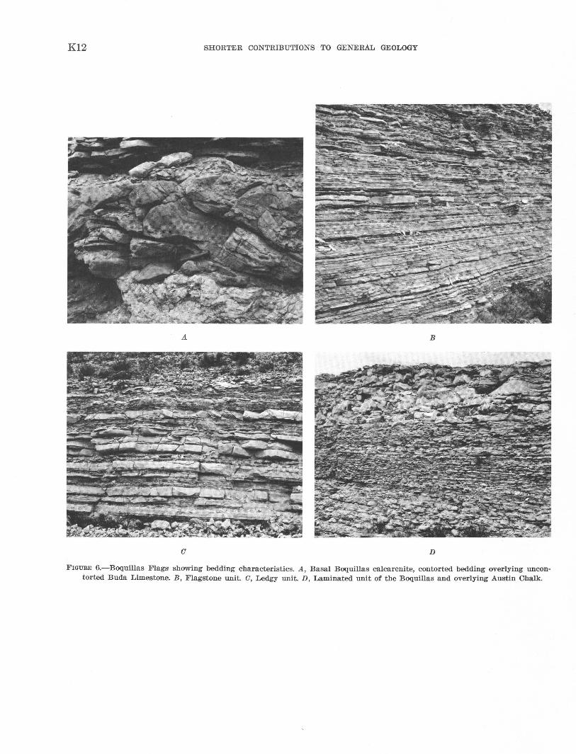
The pinch-and-swell unit at the base of the Boquillas Flags is the most widespread and the most easily recognized of the four un~ts. I•t is composed of alternating tlrin beds of calcarenite and shale. The calcarenite is fine to medium grained, fetid, laminated, and cross-laminated in beds tha.t average a;bout 3 inches thick but that swell to as much as 1 foot thick. Many of the calcarenite beds are lens shaped and give the characteristic pinch-andswell .appearance. In one thin section the grains were seen to be spheres--probably oolites--with a di·stinot bimodal size range; the large spheres are about four times the size of the small ones. A few of the spheres appear to be of organic origin. The matrix between spheres is crystalline calcite (spar) . The interbeds of shale are generally silty. Locally, a distinctive bed or a few feet of beds occur at the base of the uni·t. Near where U.S. Highway 90 crosses Lozier Canyon, 6- 7 inches of darkgray fetid siltsbone containing broken shells overlies 1-2 inches of black shale. Near Langtry t he ba:sal beds, 2-3 feet thick, oare composed of laminated or massive wellsorted very ·fine grained dolomitic calcarenite oontaining abundant quartz grains. In a roadcut a quarter of a mile west of Langtry, these beds are contorted and contain fr.agmen'ts of the underlying Buda (fig. 6A). A mile or more farther west this "distinctive" bed appears to be homogeneous and structureless. The thickness of the pinch-and-swell unit within the mapped area ranges from wbout 19 'to 28 feet; no significant pattern of thickness distribution was noted.
Thin and very thin beds of the fl~<TStone unit overlie the pinch-and-swell unit. The fl·agstone unit is formed of beds of clastic grains of silt to fine sand size of mostly calcite composition alternating with beds of limy shale. The bedding within the flagstone unit is strikingly even
K12 SHORTER CONTRIBUTIONS TO GENERAL GEOLOGY
A B
(J D
FIGURE 6.-Boquillas Flag·s showing bedding characteristics. A, Basal Boquillas calcarenite, contorted bedding overlying uncontorted Buda Limestone. B, Flagstone unit. a, Ledgy unit. D, Laminated unit of the Boquillas and overlying Austin Chalk.
COMSTOCK-INDIAN WELLS AREA, TEXAS K13
(fig. 6B). The thicker beds ( 3-4 in.) are suitable for use as flagstones and have been qua,rried in the western and central parts of the area. Thin, easily wea;thered beds that are probably bentonite are also present in the unit. In none of the nonbentonite beds do grains, silt size or larger, composed of insoluble minm·als seem to exceed 5 percent. The -thickness of the unit ranges from about 70 to 95 feet, except near the Agua Verde fold, where the unit is only 65 feet thick on the fold and is as much as 120 feet thick just east of the fold.
The ledgy unit of the Boquillas Flags, above the flagstone unit, is also composed dominantly of very evenly bedded fine-grained clastic rocks composed of calcite and less than 5 pereent insoluble material. It, however, contains beds of ~somewhat greater thickness (fig. 60), a few of which do not show evidence of clastic origin. These beds, characteristic of the unit, are nearly pure li1nestone; they weather white and form ledges and blocks that, though not large, are obvious on the surface. Locally, the ledges, generally 6-8 inches thick, contain ammonites. The unit ranges in thickness from about 2·5 feet to about 40 feet and shows no appa.rent meaningful pattern of change.
The uppermost, or laminated, unit is the least exposed and forms the smallest outcrop area of the units of the Boquillas Flags. It is similar in composition to the ledgy unit hut has thinner bedding (fig. 6JJ), sparse resistant limestone beds, and proba:bly a greater clay content. Characteristic of the uppermost unit are its darker weathered surfaces and zones of hemiasters tha.t generally weather free. The unit seems to be more homogeneous and to have a higher proportion of clay in the eastern part of the area, where the bedding in weathered
exposures is difficult to see. At the top, it contains some beds of Austin Chalk type lithology and grades within a few feet into the overlying Austin Chalk. The thickness of the laminated unit is about 40-50 feet.
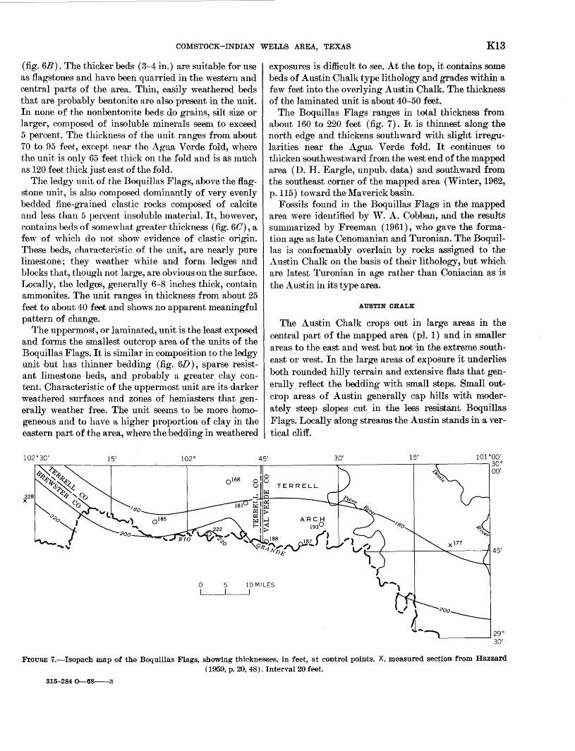
The Boquillas Flags ranges in total thickness from about 160 to 220 feet (fig. 7). It is thinnest along the north edge and thickens southward with slight irregularities near the Agua Verde fold. It continues to thicken southwestward from the west end of the mapped area (D. H. Eargle, unpub. da•ta) and southward from the southeast corner of the mapped area (Winter, 1962, p.115) toward the Maverick basin.
Fossils found in the Boquillas Flags in the 1napped area were identified by W. A. Cobban, and the results summarized by Freeman (1961), who gave the formation age as late Cenomanian and Turonian. The Boquillas is conformably overlruin by rocks assigned to the Austin Chalk on the basis of their lithology, but which are latest Turonian in age rather than Coniacian as is the Austin in its type area.
A US TIN CHALK
The Austin Chalk crops out in large areas in the central pa.rt of the mapped area (pl. 1) and in smaller areas to the east and west but not in the extreme southeast or west. In the large areas of exposure it underlies both rounded hilly terrain and extensive flats that generally reflect the bedding with small steps. Small outcrop areas of Austin generally cap hills with moderately ·steep slopes cut in the less resistant Boquillas Flags. Locally a:long streams the Austin stands in a vertical cliff.
15' 102° 45' 30' 15' 101 coo· ~~~~------~------~----~------------~------------~~------------,---~--------,30°
0 I
5 I
10 MILES I
TERRELL
00'
29° '-------------' 30'
FIGURE 7.-Isopacb map of the Boquillas Flags, showing thicknesses, in feet, at control points. X, measured section from Hazzard (1959, p. 20, 48). Interval20 feet.
315-284 0-68-3
K14 SHORTE1R CONTRIBUTIONS TO GENERAL GEO:UOGY
In the mapped area the Austin Cha.Ik is a relatively simple unit without recognized va,riations of lithology or internal unconformities thalt could be used as a basis for subdivision. Because only the lower part of what once must have been a much greater thickness remains, there are no problems of subdivision similar to those to the southeast (Adkins, 1956, p. 110) and to the west (West Texas Geological Soe~iety, 1955, p. 33).
Beds of the Austin Chalk are of two lithologies: a dominant type of hard limestone in thin to thick beds without internal la,minations; and very thin to thin interbeds of laminated elayey limestone. The dominant hard limestone is very pale orange to yellowish-gray rathe'r pure limestone (table 1) in which microscopic spheres of organic origin are abundant. Iron oxide minerals after pyrite and 1Sparse quartz grains were the only accessory minerals seen. The interbeds of clayey limestone are da,rker but similar, exeept for the increased amount of clay, to the hard limestone. As seen in thin secltion, the laminations of the interbeds are alternating clay rich and day poor. The clay fraction of the clayey limestone interbeds is about 20 percent.
On the outcrop the bedding of the Austin is striking because of the ease of weathering of the dark clayey interbeds compared with the resistance of the light hard limestone beds. Some hard limestone beds are separated only by a bedding plane, and some particularly thick beds contain a subhedding-plane fracture. The thickness of the dominant hard limestones, as measured at the roadcuts of U.S. Highway 90 just east of Lozier Canyon, averages 1.'25 feet and ranges from 0.15 to 3.40 feet. The interbeds of clayey limestone average about 0.45 foot in thickness and range from 0.05 to 3.85 feet; however, the bed 3.85 feet thick is the only bed thicker than 1.30 feet. This one anon1alously thick bed of the laminated clayey limestone is seen in the roadcuts of U.S. Highway 90 for about 10 miles. It is about 75 feet above the base of the Austin Chalk and, although striking, does not seem to be significant as a break between possibly different units of the Austin Chalk. The dominant hard beds break with conchoidal fracture and weather to a surface that superficially resembles dirty chalk. The interbeds crumble at the surface and form reentrants between the hard beds.
The maximum preserved thickness of the Austin Chalk in the area shown on plate 1 is about 200 feet. This is probably only a small part of the original thickness, which is incalculable from available data. To the southeast in Maverick County about 1,250 feet of beds may be assigned to the Austin (Hazzard and others, 1956, p. 124), and to the west, thicknesses of 330--400 feet and 220--450 feet are given for two members of the Austin (West Texas Geological Society, 1955, p. 2:1,);
however, tJhese thicknesses cannot be extrapolated into the mapped area without better knowledge of the paleogeography of Austin time.
The fossils in the Austin Chalk and their age designations were summarized by Freeman (1961). It is sufficient to mention here that the lowermost 35 feet of beds is Turonian in age and that a fossil zone of Coniacian age is 70-80 feet above the 'base; this zone contains Inoceramus cf. I. inconstans Woods. The highest identifiable fossils, from about 125 feet above the base, are also I. inconstans.
The Austin Chalk is overlain unconformably by gravel that is early Pleistocene and probably as old as late Pliocene. This gravel, the older gravel of this report, rests unconformably upon all the Cretaceous rocks and is virtuaily unfolded. Nothing is known of the paleogeography of the area during the period represented by the unconformity. The structural history during this period is discussed later.
In the mapped area the Austin Chalk conformalbly overlies the Boquillas Flags, and the lower beds of tJhe Austin are of Turonian age (Freeman, 1961). As pointed out by Young ( 1963, p. 102), this indicates that Austin deposition started earlier in the Rio Grande embayment (the area of this report) than it did in central Texas. Austin deposition during Turonian time as far east as Brackettville, about 30 miles southeast of the mapped ,area, is indicated by poorly preserved fossils collected 'by W. A. Cobban and the writer. The reported. unconfor1nity near Brackettville (San Angelo Geological Society, 1956, p. 66) does not appear to separate Turonian beds from Coniacian ones or to be of particular significance. East of Brac:kettville an unconformity separates a solely Coniacian Austin from Turonian Boquillas (Eagle Ford).
West of the mapped area, near the type section of the Boquillas Flags in Big Bend N ationa.I Park (fig. 1), the Boquillas-Austin contact is placed about 130 feet above a distinctive "Crioceras" ledge (West Texas Geological Society, 1955, p. 72-73). Daugherty and Powell ( 1963) also placed the contact well above the "Criocera:s" ledge in the Pi co Etereo area of Mexico (fig. 1), an area that lies between the Boquillas type area and the area rna pped by the present writer. They considered the "Crioceras" ledge as "Late Turonian?" and placed the TuronianConiacian contact as questionably at the top of the ledge. A section from the top of the Buda Limestone to above the "Crioceras" ledge at Del Norte Gap (fig. 1), north of the type area of the Boquillas, was measured iby the writer. (See Eifler, 1943, pl. 5, for geologic map.) .... 1\:bove the Buda is 4 feet of beds assigned to the pinchand -swell unit of the Boquillas, and this is overlain by 190 feet of flaggy or platy beds beneath the "Crioceras"
COMSTOCK-INDIAN WELLS ARE.A, T.EXAS K15
ledge. The lower 104 foot of these flaggy beds resembles the flagstone unit, and the remaining 86 feet of beds resembles the Austin Chalk, except that the bedding is similar to that of the Boquillas.
Fossils found in the "Crioceras" ledge at Del Norte Gap were identified by vV. A. Cobban as follows:
Pelecypods : Inoceramus cf. I. subquadratus SchlUter Didymotis variabilis Gerhardt
Cephalopods : Allocrioceras hazzard·i Young Barroisiceras sp.
Remarks: Late Turonian.
Fossils from 25 feet above the "Crioceras" ledge, still in beds with Boquillas-like bedding, were identified by W. A. Cobban as follows:
Pelecypod: Inoceramus subquadratus Schl'liter
Cephalopods : Scaphites cf. S. frontierensis Cobban Baculites sp. (smooth) Gauthiericeras? sp. or Bart·oisiceras? sp. uncoiled ammonite undet.
Remarks: Probably late Turonian.
So, the "Crioceras" ledge of the Big Bend area (West Texas Geological Society, 1955) seems to be of late Turonian age, but the depositional conditions that produced Boquillas-type bedding may have prevailed longer there than in the mapped area, where the "Crioceras" ledge is not present. South of Del Norte Gap, near the type area of the Boquillas, 1the Boquillas-type sediments are thicker beneath the "Crioceras" ledge than they are in the area of the present report and extend about 130 feet above the "Crioceras" ledge (West Texas Geological Society, 1955, p. 72-73).
In summary, the depositional environment that produced the Boquillas Flags 1nay have }a,sted a shorter time in the mapped area than in the type area. Even if one considers only the rocks of approximately tJhe same age, it seems that a much thicker and more uniform section was formed in the rt:ype area. This suggests thalt the center of the basin of deposition was nearer the type area and that the area sho·wn on plate 1 was more shelflike in relationship. However, before lt:.he close of Turonian t;ime, condiJtions in the 1napped area changed to permit Austin deposition while Boquillas deposition probably continued to the west. This change may refleot downwarping of both the mapped area and the Maverick basin to the southeast but also may have been due partly to distance from the source area of clastic detritus. The Boquillas type area probably had a source of detritus to the north 'allld northwest, and the Eagle Ford
Formation east of Brackettville probably had a source of detritus to the northeast. The Comstock-Indian Wells area was much farther from any source of clastic debris, 'and thus a nearly pure lime facies ( tJhe Austin Chalk) could have been deposiJted there while clastic rocks were being deposited in the other areas. Deposition of 'the Austin Chalk facies spread eastward ·as renewed subsidence in northeast Texas, following the uplift that produced a late Turonim1 unconform1ty, reduced the supply of clastics.
QUATERNARY ROCKS
OLDER GRAVEL
The older gravel of the mapped area. is not dated, but it probably was deposited during a single period of aggradation during which the streams of an integrated system shifted slightly from place to place. Deposits of the gravel are most abundant in the western and southeastern parts of the area but also are present in the central part (pl. 2). West of the Terrell-Val Verde County line the depo·sits of older gravel cap hills and narrow-to-broad ridges, whereas farther east they are generally in stlill-recognizable segments of old valleys. In the Feely quadrangle, however, the oldest parts of the gravel occupy hilltops. The outcrops of the gravel 'aJ'e poorly exposed and underlie areas of low local relief.
The principal stream of the aggrading system entered the area from the west and crossed the central part of the Indian Wells quadrangle (pl. 2) . From the mouth of San Francisco Creek to 1the mouth of the Pecos River ~this stream was mostly soutJh of the present Rio Grande, except for rut least a t.emporary swing into the mapped area near the moruth of Lozier Canyon. From the mouth of the Pecos River the stream probably flowed southeastward for a short distance before turning eastward again and crossing the southern part of the Feely quadrangle. Both large and small tributaries joined the principal stream within the mapped area (pl.2).
Deposits of the older gravel are two general types: those that contain resistant rock fragments derived from west of the 1napped area, and 1those that contain rock fragments derived from limestone terranes considered to be of more local source (pl. 1). Both types are dominantly conglomerate wi,th minor coarse sandstone beds and mrutrix. The individual deposits have an average grain size of 1-2 inches in diameter and a maximum fragment size of 5 inches to 2 feet. The larger fragments are rounded or subrounded and tend Ito be subspherical to disk shaped. The basal part of a small deposit about 2lj2 miles southeast of Pumpville contains a jumble of angular blocks as much as 3 feet long of locally derived
K16 SHORTE1R CONTRIBUTIONS TO GENERAL GEODOGY
Austin Chalk. The deposits with delbris considered to have been derived from a local source consist of fragmelllts of limestone and chert, whereas those with debris derived from the west consist of fragments of limestone, chert of several colors (mostly dark gray, but also white, black, green and red), dark-olive siltstone with siliceous cement, quaDtzite, volcanic rocks of porphyritic and microcrystalline textures, milky quartz, and banded chalcedony.
The older gravel in the mapped area occurs as erosional remnants of once larger deposits. Remaining remnants range from a veneer a few inches thick of loose resistant pebbles to caliche-cemented beds probably as much as 50 feet thick. Bedding is poor in the few crosscut exposures. In the western part of the Indian Wells quadrangle there is a crudely defined layering in the gravel. A layer composed of rounded limestone pebbles that average 1 inch in diameter occurs at ~the base. This is overlain by a more definite layer of mixed well-sorted and rounded limestone and fine-grained siliceous pebbles thrut also average 1 inch in diameter. The top layer is characterized by cobbles of quartz porphyry with a maximum diam~ter of about 1 foot. In the Feely quadrangle the oldest part of the gravel is composed of limestone and chert fragments. This deposit is marginal to and topographically higher than the main mass of the deposits which consist of irrterlayered limestone-chert debris and debris derived from west of the mapped area.
One of the best exposed and most easily accessible remnants of the older gravel is in the U.S. Highway 90 roadcut 2 miles west of the bridge spanning Lozier Canyon. The W egt Texas Geological Society ( 1959, p. 32-33) pictured this exposure and described it as
45 feet of gravels well cemented near base, resting on Austin chalk. Cobbles as much as 10 inches in size may be found in outcrop. Pebbles and cobbles of fossiliferous Coman.che,an Cretaceous limestone, dark banded chert (Maravillas?) and various types of igneous rock, including obsidian, are present. One pebble of chert conglomerate in chert matrix was found, which is lithologically similar to basal Tesnus conglomerate.
Older gravel deposits to the north and \vest of the western part of the mapped area \vere shown by Darton ( 1933, sheet 13) and are also shown by the present writer on plate 2. Darton described the gravel as containing "chel'lt, sandstone with Pennsylva.nian fossils, and novaculite, from the Marathon uplift, and lavas from the Davis Mountains.'' Also shown on plate 2 are outcrop areas of older gravel in Mexico. Not shown on plate 2 are occurrences of the Uvalde Gravel west of the Anacacho Mountains tha.t .the writer believes to be equivalent to the older gravels. The bulk of the Uvalde Gravel is considered to have been deposited by streams draining the Edwards Plateau (Sayre, 1936, p. 66-67),
which explains the composition of chert and limestone; however, west of the Anacacho Mountains the Uvalde Gravel contains pebbles and cobbles of igneous rocks and quartzite that must have been derived from the west (Bennett and Sayre, 1962, p. 57-58). Other gravel deposits that may be equivalent in their lower parts to the older gravels are in Sanderson Canyon at Sanderson and along Downie Draw (Christner and Wheeler, 1918, p. 16); both places are north of the west edge of the mapped area (pl. 2).
There is no definite evidence of the age of the older gravels. The writer believes they are equivalent to a.t least part of the Uvalde Gravel because both seem to be products of a physiographic event that is only known to have occurred once. The Uvalde Gravel is considered Pliocene(?) by the U.S. Geological Survey, but it also is undated by direct evidence. The older gravels of the mapped area may be Pliocene, but until evidence of this age is found, the writer prefers to retain the Pleistocene a.ge designation he used on the earlier maps of the area (Freeman, 1964a, b, c).
The paleogeography of the older gravels is incompletely pictured on plrute 2. The beginning of deposition of the gravels was probably almost synchronous with relative uplift of the region west of the mapped area. First, downcutting of canyons within the uplift probably coincided with the first deposition w~thin the mapped area. Later the canyons themselves were partly filled, as postulated for Sanderson Canyon and Downie Draw. Upon leaving the restricted canyons of the uplifted region, the streams were ruble to shift laterally and deposit gravel over broad areas. The streams entered the mapped area in the Indian Wells and Malvado quadrangles and are assumed to have merged to form an ancestral Rio Grande. The ancestral Rio Grande then flowed eastward, crossed the Feely quadrangle, and then bent to the southeast. At one time it must have extended nearly to the Anacacho Mountains.
The uplift west of the mapped area was probably concurrent with the uplift east and north of the mapped area that initiated deposition of the Uvalde Gravel east of the Anacacho Mountains, and deposition of locally derived older gravel in the Feely quadrangle.
TERRACE GRAVEL
Terrace-gravel deposits occur along the rivers and the major streams of the area. They range in position from a few feet to about 300 feet above the present stream level and are highest near the Rio Grande and the Pecos River. Along the tributaries the terrace deposits are highest above the stream level near the mouths and are closer to the water level upstream, commonly merging with alluvium at the headwaters of the tributaries. Con-
COMSTOCK-INDIAN WELLS AREA, TEXAS K17
sequently, near the headwaters, parts of the deposits shown on plate 1 as alluvimn .are equivalent in age to deposits mapped elsewhere as terrace deposits. Included in the terrace gravels of plate 1 are deposits of younger alluvium too small to be mapped separately and a few talus deposits. The only well-formed talus deposits in the mapped area are located where terrace deposits occur and are of the same age. Except for rock falls along the canyons, no talus deposits are forming at present. The lowest terrace along the Rio Grande is mapped with alluvium and is discussed later.
The terrace-gravel deposits can be divided into two groups on the basis of composition of the gravel. In one group, located largely along the tributaries, the gravel is of local origin and composed of limestone and chert with minor amounts of other resistant rocks derived from deposits of older gravel. In the other group, mostly adjacent to the Rio Grande, the gravel contains not only the locally derived limestone and chert but many rock types foreign to the area, such as a variety of volcanic rocks, especially porphyries, quartzite, milky quartz, and banded chalcedony. The pebbles foreign to the area are mostly rounded, whereas those of local derivation are mostly subrounded.
The terrace-gravel deposits are poorly exposed except in local stream cuts. In most places they underlie a soilcovered flat or slope and the pebbles or cobbles are scattered in and on the soil. Where well exposed the deposits are generally a light to moderate yellowish brown, although they locally have a reddish tint. Where largely free of matrix the deposits show the gray of the dominant limestone pebbles The terrace-gravel deposits have a wide range of grain size-from silt to boulders as much as 3 feet in diameter-are unsorted to moderately sorted, and contain fragments that are angular to rounded. Some of the deposits are weakly cemented with caliche, and one deposit showed considerable solution of the tops of limestone pebbles and deposition of minor amounts of calichelike limestone between the pebbles.
On the individual quadrangle rna ps of this area (see p. K1} the terrace gravels were separated into three units in an attempt to show age equivalence. The attempt was proba:bly not totally successful. Along the tributaries the different terrace levels are generally easily differentiated and are probably related to distinct episodes of down -cutting of the streams or to climatic changes. However, along the Rio Grande and the Devils River in the eastern part of the area, the terrace gravels commonly merge one with another, probably because these rivers eroded downward at a uniformly continuous rate.
The terrace gravels mostly form the typical flattopped deposits, but locally, especially along the Devils
River, the deposits slope toward the river and superficiaHy resemble talus or old fans. Most of these pseudotaluses contain rounded stream cobbles and were probably formed from the erosion of the flat-topped deposits. Some of the gently sloping deposits adjacent to the Rio Grande in the southeast corner of the mapped area are composed of locally derived debris and may be slope wash deposited on a stripped surface at the top of the resistant Georgetown Limestone rather than terrace gravel.
The terrace-gravel deposits are assumed to be mostly Pleistocene in age, but no direct evidence for dating them was found.
ALLUVIUM
Material mapped as alluvium occurs along the rivers and tributaries as well as in higher topographic positions along abandoned streams and in upland depressions. It includes the lowest terrace deposits along the Rio Grande, deposits of terrace gravels and older gravels that are too small to be mapped separately or that are still reached by stream action, and hillslope deposits adjacent to streams. Some of the deposits are active in the sense that the material is moved periodically during floods, but other deposits are residual from an older period of aggradation.
The alluvium is composed of a great variety of lithologic types. The lowest terrace along the Rio Grande is, at least locally, well-sorted silt as much as 50 feet thick. Some of the deposits in high topographic posi· tions, especially the surficial fill above subsidence areas, are also fine grained but mainly poorly sorted. Most of the deposits along streams are poorly sorted gravel with a sand-and-silt matrix, but some are gravel without much matrix, and a few are composed of angular blocks as much as 3 :feet long. The alluvium is generally different shades of yellowish brown. Along the Rio Grande the alluvium contains a high percentage of rounded rock debris derived from outside the area. Most of the deposits along the other streams contain somewhat angular debris of local derivation with a component of rounded debris derived from terrace deposits and the older gravel. The deposits are thin in most places but are 60 feet thick where penetrated by a well beside the Devils River near the north edge of the area rna pped on plate 1.
The material m·apped as alluvium ranges in age from as old as the older gravels, especially in the Feely quadrangle, to as young as the latest flood. The lowest terrace along the Rio Grande, at the mouth of the Devils River, about 3 mile~ south of the mapped area, contains archeological evidence of aggradation through a period of about 8,000 years that ended about 500-1,000 years ago (Mark Parsons, oral commun., 1963).
K18 SH0RTE1R CONTRIBUTIONS TO GENERAL GEOLOGY
STRUCTURE
Structurally, the Comstock-Indian Wells area is part of the Rio Grande embayment, a broad syncline that Plunges to,vard the Gulf of Mexico except at the west end, where it is interrupted by the folds of the Mexican !lighland and by the Marathon dome. The mapped area Is one of generally lmv dips along the south edge of the ~dwards Plateau physiographic section. It includes, at Its west end, a small part of the Mexican Highland physiographic and structural section, which contains moderately dipping folds and related faults. The southeast corner of the area is about 10 miles north west ?f the edge of the Gulf Coastal Plain, but this boundary IS not. sharply marked either structurally or physiographwally.
FOLDS
MEXICAN HIGHLAND
Structures of the Mexican Highland are present in the mapped area in the southwestern third of the Indian Wells quadrangle (Freeman, 1964a) and in the Dryden Crossing quadrangle (Sharps, 1964). These structures (pl. 1) are part of three major asymmetrical anticlines and associated synclines, secondary folds, and minor faults. The major anticlines have steep northeast flanks and _broad crestal areas. For most of their lengths in Mexico, south of the mapped area, they trend northwest.
The northeast flank of the westernmost of the three major anticlines is nearly vertical in Mexico and to the northwest it is overturned and forms ~ minor thrust that enters the southernmost part of the Indian We~ls.qua~rangle (pl.~). The second of the three major antichnes Is about 6 miles northeast of the first, but it changes trend a few miles south of the Rio Grande and in the mapped area has a strike of about N. 80° W. The broad crest of this anticline breaks up into several secondary folds that die out to the northwest. The third major asymmetrical anticline, the Agna Verde fold, lies about 10 miles farther northeast and generally parallels the other two. In the mapped area it trends about N. 45° W. and dies out to the northwest in the Dryden Crossing quadrangle. The Agua Verde fold is smaller than the other two and, unlike them is not associated with minor faults. Also, as seen o;1 aerial photographs, it dies out to the southeast in Mexico probably in a simple plunge. It is an outlier of th~ Mexican Highland folds in the Rio Grande embayment.
The asy1nmetrical anticlines of the Mexican Highl~nd structural area were probably formed by compressive forces from the southwest during the Late Cretaceous. On the Agua Verde fold, J. A. Sharps (written commun., 1967) found that the Del Rio Clay, the
Buda Limestone, and the Boquillas Flags thin across the crest of the fold, and he attributed the thinning to be the result of active uplift at the time of deposition of the formations. That further folding occurred after deposition of the Austin Chalk-the youngest bedrock unit-is certain but undated. A small deposit of older gravel, Pleistocene and possibly Pliocene in age, near the crest of the fold is at grade with other older gravel deposits of the area, and, hence was prob.ably deposited after folding had ceased. The west side of the Terrell arch (fig. 3) is roughly parallel to the Agua Verde fold and also was active during Del Rio time; however, uplift on it seems to have largely ceased during early Buda time.
EDWARDS PLATEAU
The folds of the Edwards Plateau part of the mapped area are mostly small-amplitude features related to the Rio Grande embayment, except for the small part of the Marathon dome in the northwest corner of the Indian Wells quadrangle and possibly for the arcuate east-west anticline across the southern part of the Feely and the Mouth of Pecos quadrangles (Sharps and Freeman, 1965).
A prominent feature of the Rio Grande embayment in the west end of the mapped area is the irregular basin in the north-central part of the Indian Wells quadrangle. It is probably best considered as the northwest end of the embayment but in somewhat separated from the rest of the embayment owing to effects of the Mexican Highland folding and the Marathon dome uplift.
In the central part of the mapped area, the rocks dip generally southward toward the trough of the Rio Grande embayment. Near the east edge of the area, the dip toward the embayment is interrupted by a terrace in the Shumla and the Bakers Crossing quadrangles (pl. 1) and by a dome and the arcuate east-west fold in the Feely quadrangle. The terrace is a minor feature but may have controlled the later development of a large faulted subsidence feature. This terrace, and the later subsidence along it, is probably the fault zone "A" of Calvert (1928), described as a discontinuous belt marked by crushing. The present writer rejects the idea of such a fault zone in the surface rocks and attributes the faults seen by Calvert to subsidence above areas of large-scale removal of limestone by ground-water solution along a structural terrace. The belief that the terrace was formed by movement of a fault beneath the Cretaceous rocks is a reasonable one but cannot be proved without more data on subsurface structure. Certainly the terrace (pl. 1) shows a parallelism to the north end of the buried Devils River uplift of Flawn (1959, p. 76); however, it also is subparallel to the
COMSTOCK-INDIAN WELLS AREA, TEXAS K19
arcuate east-west anticline in the southern part of the Feely quadrangle that is not explained by Flawn's interpretation of the subsurface geology. The terrace is also roughly parallel to the north edge of the central area of Lozo and Smith ( 1964, figs. 2, 6), and it may be postulated that the terrace formed by differential compaction bebveen the rocks of the central area and those of the northern area (Lozo and Smith, 1964, fig. 6). This hypothesis likewise fails to account for the parallelism between the terrace and the arcuate east-west anticline to the south.
The dome just south of Comstock, in the Feely quadrangle, has been termed the "l{elly anticline" (West Texas Geological Society, 1959, p. 45-46, folded plate) but does not seem to the present writer to be a simple anticline. The regional south-southwest dip is interrupted by an anticline and paired syncline which trend N. 20° '"·and by another short anticline and syncline to the 'vest which trend about N. 75° W. (Sharps and Freeman, 1965) ; together these structures cause a reversal of dip and possibly closure.
Trending roughly eastward across the southern part of the Feely quadrangle is a broad arcuate anticline ;,vith a faulted steep northern flank. On aerial photographs the ends of the fold, beyond the mapped area, can be seen to bend south ward before dying out by pi unging gently. The fold and associated faults seem best explained by a simple northward-directed compressive force. The fold is seemingly unrelated to other structural features in the region, except to the terrace about 16 miles to the north.
FAULTS
The faults mapped in the area shown on plate 1 fall readily into three groups: those associated with the folds; those genetically related to the joint systems; and those formed concurrently with the subsidence areas. A few features are common to all three groups. Except for the small thrust in the Indian Wells quadrangle (pl. 1) , all the faults are minor and are vertical or nearly so. Narrow grabens occur in all three groups, although the scarcity of grabens among the faults related to joints suggests that perhaps these grabens are due to otherwise unrecognized subsidence caused by bedrock solution along or beneath the joints.
The faults associated with folds are short and of small displace1~1ent (pl. 1). Those in the area of the Mexican Highland folds are mostly roughly parallel to the axes of rthe folds. The faults near the crest of the arcuate anticline in the southern part of the Feely quadrangle (pl. 1) are at an angle of about 30° to the fold axis and are parallel to a dominant trend of the joints in the eastern part of the mapped area. The maximum dis-
placement on these faults is about 150 feet. The faults along the terrace in the Shumla and the Bakers Crossing quadrangles (pl. 1) are also mostly parallel to the same joint trend. The easternmost group of faults on the terrace have the most displacement, about 200 feet, but most of this displacement is probably due to subsidence caused by bedrock solution.
All the faults genetically related to the joint systems are of small displacement-not more than a few feet. They have trends similar to those in nearby joints. The faults formed concurrently with the subsidence areas commonly trend in agreement with nearby joints, but some also have random trends. These faults bound one or two sides of a subsidence area and also occur within subsidence areas.
JOINTS
tT oints are a nearly ubiquitous feature of the mapped area, both geographically and stratigraphically. They are present in competent beds that range in age from the oldest exposed beds to the caliche zone of terrace gravels. The spacing between joints is variable within the area, but no special study was made of it. Apart from a variability of spacing with lithology, there is a varia~ility geographically within a single lithology. Most str~king is the wide spacing of joints in the more massive units of the Georgetown Limestone in the northeast corner of the area compared with the spacing in the massive units in the western part of the area. Throughout the area the joints are mostly vertical, and generally they are either tight or open owing to solution along them. Many appear to be tight because secondar;y calcium carbonate has been deposited along previously open joints; the secondary lime either i~ m?re coarsely crystalline or is indistinguishable in grain size from the bedrock. Small rock fragments seen along several seemingly tight joints must have dropped at least tens of feet at a time when the joints were open.
The joints in the area are shown in ~hree .ways and are plotted on rose diagrams (pl. 1) . First, lineaments that are visible on aerial photographs are shown on some of the detailed maps of the area (Freeman, 1964a, b, c, 1965; Sharps and Freeman, 1965 ~ .. These lineaments are mostly, if not entirely, caused by JOints that are made obvious by growth of vegetation along them. Second, regular successions of straight stream segments that are probably joint controlled were plotted for some areas. These segments are best seen along Dead Mans Canyon and Lewis Canyon in the Shumla quadrangle (Freeman, 1964c). Third, visible joints ~neasure~ on the ground at several localities are shown In the diagrams on plate 1. .
Lineaments were carefully plotted only Ill the eastern part of the area; there they have a dominant northeast

K20 SHORTE1R CONTRIBUTIONS TO GENERAL GEOLOGY
trend, mostly ranging from N. 10° E. to N. 70° E. Between Langtry and the mouth of the Pecos River, the lineaments clearly show two dominant trends (about N. 30o E. and about N. 65° E.) differing by 30°-40° and probably indicate a conjugate set of joints. Lineaments anomalous to the general northeast trend are present in the northwest corner of the Langtry quadrange, where a N. 15° E. trend is dominant, and in the north half of the Bakers Crossing quadrangle, where a nearly dueeast trend is common. Lineaments with a general northwest trend are rare but do occur scattered throughout the area. Such a northwest trend is dominant in Mexico, south of the Rio Grande, in the Indian Wells quadrangle. Lineaments in the north half and in the southeast quarter of the Shumla quadrangle were plotted on rose diagrams (pl. 1). In both areas a dominant N. 40° E. trend is evident. A small group of lineaments in the northwest quarter of the Bakers Crossing quadrangle cut the Georgetown Limestone but are not visible in the overlying Buda Limestone. These have an average trend of N. 20° W. and are associated with minor folds also restricted to beds below the Buda. These are probably genetically related to folding of the Terrell arch during Del Rio time. (See "Del Rio Clay.")
Straight stream segments that seem to be structurally controlled are common in the Shumla quadrangle. Only rarely was a joint found along such a segment, although commonly the bedrock was well enough exposed to show a controlling joint if one were present. A possible explanation is that stress in the limestones has produced planes of strained limestone of increased solubility to which the streams become adjusted during downcutting. That such an idea is valid is also suggested by the presence of small linear solution grooves in areas of flat limestone exposures where, although the limestone is totally exposed at the base of these grooves, no joint could be seen. Along the straight segments of the Pecos River, the higher slopes of the canyon show that the river at a higher level flowed in smoother curves and that the straight segments have developed during downcutting. Straight stream segments in the north half and in the southeast quarter of the Shumla quadrangle were plotted on rose diagrams (pl. 1). The diagram does not show a significant maximum for the southeast quarter of the quadrangle, as the segments trend in all directions; however, there does seem to be a dominant trend maximum of about N. 5° W. for the north half of the quadrangle. In neither area does the pattern of the straight strea1n segments correspond to the lineament pattern.
The visible joints at nine localities within the mapped area were measured and plotted (pl. 1) . These localities were all in the upper half of the Georgetown Lime-
stone. The joints in and adjacent to Dead Mans Canyon in the southeast quarter of the Shumla quadrangle are of special interest as they can be related to the lineaments and straight stream segments in the same area. The plot of all visible joints shows maximum trends of N. 40° E. and N. 15° W. It is strikingly different from the plots of the lineaments and the straight stream segments, although the dominant trend of the lineaments coincides with one maximum on the plots of all visible joints. No visible joints have an almost due-east trend to correspond to the most common trend of the straight stream segments.
Of the nine rose diagrams of all visible joints, only two--for Dead Mans Canyon and for the mouth of Lozier Canyon-show a pair of equally developed maximums of trend direction. The angles between the maximums are 55° and 65° respectively. The resultant between the maximums on both diagrams is about normal to the local structural contours, and it is postulated that the visible joints were formed by compressive forces that caused the folding.
Six of the rose diagrams of all visible joints-those for the northwestern part of the Indian Wells quadrangle, Leone Canyon, the Martin Ranch, Magoy Creek, the Gillis Ranch, and the H. Holman Ranch-show one well-developed maximum and a second, less definite, lesser maximum. On two of the diagrams-those for Magoy Creek and Leone Canyon-the angle between the maximums is 65°, and the resultant is about normal to either a nearby fold axis or the structural contours. At these two localities the visible joints were probably formed by the compressive force that caused the folding. The principal maximum in both places is about N. 10° W., and at Magoy Creek this maximum is about normal to nearby subsidence features that are probably also joint controlled. The rose diagram for the joints in the northwestern part of the Indian Wells quadrangle also shows the principal maximum to be N. 30° W., although the angle between that maximum and the lesser maximum is about 75°, and the resultant is at an acute angle to the local structural contours. The resultant, though not normal to the nearby fold axes, is nearly parallel to the resultants at Magoy Creek and Leone Canyon. The local structure, the flank of the Marathon dome, may be a later development that did not change the pattern of joints that seem related to the same compressive forces that formed the joints at Magoy Creek and Leone Canyon-that is, the compressive forces that gave rise to the folds of the Mexican Highland. The rose diagram of all visible joints on the Martin Ranch is of doubtful significance owing to the limited number of readings; however, it shows a maximum of N. 45° E., and a possible lesser maximum of about N. 5° W., which
COMSTOCK-INDIAN WELLS AREA, TEXAS K21
gives an angle of 50°. The resultant direction is N. 20° E., which approximates the normal to the local structural contours and the nearby Aqua Verde fold, the easternmost of the Mexican Highland folds. The remaining two rose diagrams that show a well-developed maximum as well as a lesser maximum- Gillis Ranch and H. Holman Ranch, in the eastern part of the areaare similar; the principal maximum is to the northeast, and the lesser maximum to the northwest, which gives an angle of 80°- 85°. The Gillis Ranch diagram gives a resultant of N. 5° E., that is normal to the local structure. The H. Holman Ranch diagram is interpreted in relation to the local structure, the east-trending arcuate fold across the south edge of the Feely quadrangle. The maximum trend of the visible joints, N. 55° E., coincides with lineaments and faults on the crest and north flank of the fold; so the fold, the joints, and the lineaments may be related.
The rose diagram of the visible joints at Langtry and Mile Canyon is of doubtful value owing to an insufficient number of readings. It shows a maximum at N. 5° E., plus a scatter of joints with other trends. Lineaments nearby also have a north-northeast trend.
The mapped area contains many visible joints and a variety of joint-controlled features, such as lineaments, some straight stream segments, and linear subsidence areas. The trends of these joints and joint-controlled features are diverse, which suggests that the joints formed at different times as the result of different stress patterns and that they have had different histories since their formation. That many joints are related to folds seems clear. Certainly a set of joints formed during the folding of the Mexican Highland part of the area. A joint set also seems related to the gentle folds in the Edwards Plateau part of the area. Another set of joints seems to have been formed during the deformation that uplifted the Terrell arch during Del Rio time. However, the diversity of trends shown by the straight stream segments in the Shumla quadrangle does not fit the patterns of the rose diagrams for visible joints and lineaments. Probably the rocks of the area are intricately cut by many planes of weakness caused by several diversely oriented stresses that have occurred since the rocks were formed; and possibly the joints and jointcontrolled features now evident are in part a result of subsequent deformational history. Although an "open" set of joints could not be distinguished when all visible joints were examined, certain joint features probably correspond to an "open" set.
The lineaments in the area are marked by lines of increased vegetation density that must reflect an increased "openness" to water. The linear subsidence areas are also probably formed by "openness" to water move-
ment. These two features have a dominant northeast trend throughout all the area except in the southwest half of the Indian Wells quadrangle. Probably the northeast-trending planes of weakness in the rocks were preferentially "opened" during the latest deformation of the area, a general uplift that occurred in part since deposition of the older gravels-that is, during the Pleistocene.
Visible joints that trend in directions other than northeast are thus considered not to have been "opened" during the latest deformation, probably because they were not favorably oriented. Rather, they are thought to have been formed during earlier periods of deformation, mainly when the associated folding occurred. The very diverse trends shown by the straight stream segments in the Shumla quadrangle evidently represent all planes of weakness in the rock; these are planes of increased solubility although not actual joints. These planes of weakness would therefore have formed at various times since deposition of the enclosing rocks : for ex-ample, during the formation of the Terrell arch, the folds of the Edwards Plateau, and the folds of the Mexican Highland, and during the general uplift of the area; times of deformation and uplift range from the early part of the Late Cretaceous to the Pleistocene.
SURF ACE-RELATED STRUCTURES
Two very different types of structures are grouped together in this section because both are formed by processes dependent on the land surface rather than by diastrophic processes. Although of little importance in the structural history of the area, the two types of structures are prominent widespread features and were considered to be tectonic features during previous reconnaissance studies of the area. The first type consists of small-scale folds that die out downward; the second type consists of collapse features formed by subsidence of the surface rock in areas of solution by ground water.
SURF ACE FOLDS
In both the western and the eastern parts of the mapped area where broad flats have formed on the Boquillas Flags, there are small-scale folds in the nearsurface beds that are not diastrophic in origin. These are mostly sharp-crested anticlines that rise above the general flat plane of the beds involved. No intervening synclines are present, and beds a few feet below the folds are unaffected. These folds have an amplitude of as much as 4 feet and are as much as 10 feet across. In some places a series of crests are separated by undisturbed beds, but single crests were also noted. These folds in the Boquillas seem to owe their existence to their near-surface positions and may have been formed
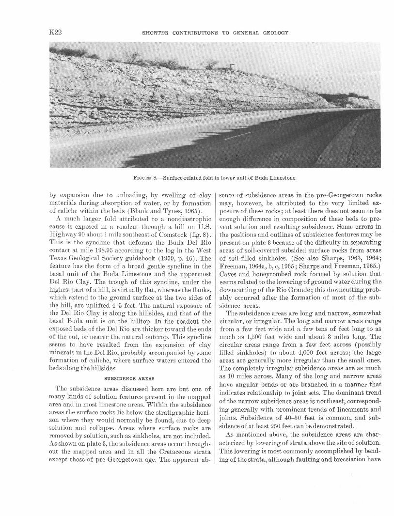
K22 SHORTE>R CONTRIBUTIONS TO GENERAL GEOLOGY
FIGURE 8.-Surface-related foid in lower unit of Buda Limestone.
by expansion due to unloading, by swelling of clay materials during absorption of water, or by formation of caliche within the beds (Blank and Tynes, 1965).
A much larger fold attributed to a nondiastrophic cause is exposed in a roadcut through a hill on U.S. Highway 90 about 1 mile southeast of Comstock (fig. 8). This is the syncline that deforms the Buda-Del Rio contact at mile 198.95 according to the log in the \Vest Texas Geological Society guidebook (1959, p. 46). The feature has the form of a broad gentle syncline in the basal unit of the Buda Limestone and the uppermost Del Rio Clay. The trough of this syncline, under the highest part of a hill, is virtually fiat, whereas the flanks, which extend to the ground surface at the two sides of the hill, are uplifted 4-5 feet. The natural exposure of the Del Rio Clay is along the hillsides, and that of the basal Buda unit is on the hilltop. In the roaclcut the exposed beds of the Del Rio are thicker toward the ends of the cut, or nearer the natural outcrop. This syncline seems to have resulted from the expansion of clay minerals in the Del Rio, probably accompanied by some formation of caliche, where surface waters entered the beds along the hillsides.
SUBSIDENCE AREAS
The subsidence areas discussed here are but one of many kinds of solution features present in the mapped area and in most limestone areas. \Vithin the subsidence areas the surface rocks lie below the stratigraphic horizon where they would normally be found, clue to deep solution and collapse. Areas where surface rocks are removed by solution, such as sinkholes, are not included. As shown on plate 3, the subsidence areas occur throughout the mapped area and in all the Cretaceous strata except those of pre-Georgetown age. The apparent ab-
sence of subsidence areas in the pre-Georgetown rocks may, however, be attributed to the very limited exposure of these rocks; at least there does not seem to be enough difference in composition of these beds to prevent solution and resulting subsidence. Some errors in the positions and outlines of subsidence features may be present on plate 3 because of the difficulty in separating areas of soil-covered subsided surface rocks from areas of soil-filled sinkholes. (See also Sharps, 1963, 1964; Freeman, 1964a, b, c, 1965; Sharp:;; and Freeman, 1965.) Caves and honeycombed rock formed by solution that seems related to the lowering of ground water during the clowncutting of the Rio Grande; this clowncutting probably occurred after the formation of most of the subsidence areas.
The subsidence areas are long and narrow, somewhat circular, or irregular. The long and narrow areas range from a few feet wide and a few tens of feet long to as much as 1,500 feet wide and about 3 miles long. The circular areas range from a few feet across (possibly filled sinkholes) to about 4,000 feet across; the large areas are generally more irregular than the small ones. The completely irregular subsidence areas are as much as 10 miles across. Many of the long and narrow areas have angular bends or are branched in a manner that indicates relationship to joint sets. The dominant trend of the narrow subsidence .areas is northeast, corresponding generally with prominent trends of lineaments and joints. Subsidence of 40-50 feet is common, and subsidence of at least 250 feet can be demonstrated.
As mentioned above, the subsidence areas are characterized by lowering of strata above the site of solution. This lo\vering is most commonly accomplished by bending of the strata, although faulting and brecciation have
COMSTOCK-INDIAN WELLS AREA, T.EXAS K23
occurred locally. Bending has taken place not only in the incompetent rocks of the Del Rio Clay and the thinbedded Boquillas Flags but also in the thick, competent beds of the Georgetown, Buda, and Austin Formations. In one well-exposed oval-shaped area about 1,000 by 400 feet, thick beds of Georgetown Limestone subsided about 55 feet, apparently without fracturing but with some opening of regional joints. Several s1nall subsidence areas were seen on topographic flats near the top of the Georgetown, and in these a central core of Buda Limestone is surrounded by a doughnut-shaped outcrop of considerably thinned Del Rio Clay. Whether the thinning was produced by annular faulting, sliding along bedding planes, or stretching of beds is not known. In a drill hole within one subsidence area near the south edge of the mapped area a completely doubled section of Del Rio was found (R. M. Price, oral commun. 1964).
Brecciation within subsidence areas is not common. The best exposed example is about 2 miles southeast of PumpviUe, where the uppermost Boquillas Flags and the basal Austin Chalk crop out in a railroad cut. There, a central breccia core about 65 feet across composed of fragments of Austin Chalk and recrystallized calcite is roughly centered in a 1nuch larger subsidence. The normally flat lying beds dip about 20° a.t the contact with the central breccia and gradually become flatter out from the breccia. In two large areas, one in the northeast corner of the Langtry quadrangle (Freeman, 1964b) and one in the south-central part of the Bakers Crossing quadrangle (Freeman, 1965), the rocks within larger subsidence areas are broken and altered enough so tJhat the original rock units are not recogniza:ble. The breccia in these areas is coarse, and large movements have occurred between some blocks. These areas apparently represent an intermediate situation between faulted and brecciated subsidence.
Faults along one or both sides of a subsidence area are not uncommon, especially bordering the long narrow areas. 'These faults appear to have resulted from movement along preexisting joints. The writer believes that the joint or joints may have served to localize the solution at depth, thus permitting the subsidence of higher rocks. Several very narrow subsidence areas are between parallel faults and have the appearance of grabens. Although the grabens in the northwest corner of the Indian Wells quadrangle (Freeman, 1964a) are not shown as subsidence areas, they may be. Many faults are also present within the large irregular subsidence areas in the Bakers Crossing quadrangle (Freeman, 1965). The larger of these faults are roughly parallel, and displacement along them approaches, and possibly exceeds,; 200 feet.
Although the type of subsidence, downwarping, faulting, or brecciation seen at the surface might be related to the depth to which erosion has exposed the original feature, direct evidence of vertical changes in the subsidence areas could not be obtained. The assumed ideal form of a subsidence area is as follows : ( 1) The floor and wrulls at the base indicate the extent of solution into bedrock (this is not to imply that a large cavern was formed prior to sudden collapse; rather, subsidence may have accompanied solution); (2) •a lower breccia fill composed of partly dissolved blocks from a higher level; and (3) near the top, down warped beds from an originally higher level; these beds may be brecciated in part. A small area in the Georgetown Limestone just north of the center of the north edge of the Indian Wells quadrangle might be interpreted as a poorly exposed floor of a former subsidence area. The surface appears to be sn1ooth but not flat, as if solution had left an uneven floor. No dripstone was noted, but a dark-reddish clay, probably a residue from solution of the limestone, was observed in small amounts. Although some bouldersized blocks are present, none could be identified as from a higher level. A vertical change might be demonstrated where the large irregular subsidence ·area along the boundary of the Bakers Crossing and Shumla quadrangles crosses Dead Mans Canyon. Near the canyon a considerable amount of reddish clay was noted in pockets in tlhe Georgetown Limestone. East of the canyon in a zone more than 2 miles wide, small-scale faults are extremely common in the subsidence area, although the rocks are not otherwise brecciated. Farther east, and higher topographically, the subsidence area consists of simply downwarped beds.
A discussion of the conditions in the mapped area during formation of the subsidence areas must be speculative. The age of formation of the subsidence areas indicates that the areas had little relief above base level at tJhe time of their formation, because, otherwise, erosive action comparable to the present rate would have destroyed most of them. In turn, the rather large vertical extent of some of the features suggests movement of the dissolving solutions to considerable depths below the surface. The failure to find or recognize dripstone associated with the subsidence features suggests that the solution took pla:ce beneath the water table. All these factors ~Suggest that the water table was near tJhe surface, that water was abundant (certainly more rubundant than now), and that solution activity occurred beneath the water table. (See discussion on solution by Bretz, 1942.)
The stratigraphic level at which solution occurred and caused subsidence seems to have been in the Georgetown Limestone throughout most of the area. However, tJhis
K24 SHORTE•R CONTRIBUTIONS TO GENERAL GEOLOGY
may be more a result of exposure than a lithologic requirement of the formation present. The solution level may have been more closely controlled by the water table and the structural features that controlled the 1novement of phreatic 'vater than by the particular formation. As an exception, the Del Rio Clay contains too few beds of limestone to permit a large degree of solution in it. Although distinctive lithology may not be the cause of the apparent concentration of subsidence features that probably formed above solution in the Georgetown, it does seem probable that the thick Georgetown Limestone was susceptible to the high degree of solution that must have taken place beneath the large subsidence areas.
Structural control of the movement of phreatic water must have been responsible for the solution beneath many subsidence areas, as many of these areas have shapes that suggest a relation to a set or sets of joints (pl. 3). Such a relation between joints and caverns in limestone is too well established to need elaboration.
The largest subsidence areas in the mapped area (pl. 3), however, are not obviously joint related. These large irregular subsidence areas lie in a slightly arcuate eastwest line from the east-central part of the Shumla quadrangle to near the southeast corner of the Bakers Crossing quadrangle and so have a distribution pattern coincident with a small structural terrace that interrupts the southwestward dip of the beds. This structural terrace probably had some effect on phreatic water movement that resulted in more solution. If the general :flow was downdip, perhaps upon reaching the structure the water was eli verted along the structure, so that the quantity of water :flowing there was greater than that :flowing through adjacent areas. Or, perhaps, the rocks along the structural terrace were more fractured than in adjacent areas and, thus, permitted more water movement and solution. However, such an increase in fracturing cannot presently be demonstrated as presubsidence.
The subsidence features are younger than the Austin Chalk, as that formation has been affected by subsidence, and older, in part at least, than the older gravel, as that unit has been affected in some subsidence areas but not in others. Movement of sur£,ace rocks within subsidence areas has continued to very recent time, but this is probably due to instability caused by surface erosion and by la·ter solution related to the present erosion cycle.
STRUCTURAL HISTORY
Structural events began to affect the rocks exposed in the mapped area as soon as the rocks were deposited. The sediments indicate that the depth of deposition changed frequently; unconformities suggest that the area was occasionally above or near sea level; the dis-
tribution of the Del Rio Clay shows that broad, gentle folding occurred before much of the Buda was deposited; and measurements of thicknesses indicate that the Agua Verde fold was active during deposition of the Del Rio, Buda, and Boquillas Formations. That movements occurred during later Cretaceous and almost all of Tertiary time is very probable, though not demonstrable. Regional stratigraphic evidence suggests that the Rio Grande embayment was a nearly constant negative area in contrast to the San Marcos arch to the east. The orogeny that produced the folds of the Mexican Highland in the western part of the area culminated after deposition of the Austin Chalk; however, the Agua Verde fold, an outlier of tlw Mexican Highland folds, had long been active. By the time of deposition of the older gravels, active folding seems to have decreased, although the gravels were probably derived from an uplifted area to the west. The present gradient of the older gravels to the east is uniform but is steeper than the gradient of the present Rio Grande, suggesting that tilting has characterized the area since deposition of the older gravels. That uplift, relative to sea level, has continued to the present is suggested by lack of lateral erosion by the narrowly entrenched Rio Grande. Terraces along the drainages suggest halts in the downcutting, but these halts have been of brief duration.
The uplift of the area since deposition of the older gravels probably has amounted to more than 400 feet in the southeastern part and to more than 800 feet in the western part. The total uplift of the area since the beginning of Austin time ranges from 2,300 feet in the southeast to 3,400 feet in the west, as indicated by the elevation of the projected base of the Austin in the synclines.
ECONOMIC GEOLOGY
The Comstock-Indian Wells area (pl. 1) cannot be considered a mineral-producing area, and there is little likelihood that it will be in the foreseeable future. Mineral products locally have been, and probably will be, used sporadically, and some ha.ve been shipped from the area. The available mineral products either require a large nearby market area or are too low grade or in deposits too small for economic operations. The a,rea contains tremendous quantities of rather pure limestone (table 1) of diverse textures, but no market is available. Soft material from the Del Rio Clay and the middle tmit of the Buda Limestone is often used as road material by the ranchers. Its value is its very softness in an area where a fill is needed for roads across hard, rough limestone outcrops. Such a road is usually adequate in this semiarid area, but it is inadequate during heavy rains. Limestone has been produced for ballast and
COMSTOCK-INDIAN WELLS AREA, TEXAS K25
crushed rock, but there is no steady producti~n for shipment outside the area.
Products that have been produced for shipment are building stone, bat guano, and manganese. The building stone has been produced in the western and central partJS of the area from the flagstone unit of the Boquillas Fla.gs, especially where the rock contains colorful alteration bands. There was no steady production during 1957-64, when the writer was in the area, but some rock was stockpiled for sale.
Bat guano has been gathered from a few of the caves in the area and from at least one abandoned railroad tunnel. Although no production figures are available, most of the guano probably was collected from Bat Cave in the northwest quarter of the Bakers Crossing quadrangle. The latest production known to the writer was from an abandoned railroad tunnel near the mouth of the Pecos River; this fertilizer was used locally.
The 1nanganese deposits in the area, although they received considerable attention frmn Roberts and Nash (1918) and Warren (1942), are small and low grade and show little prospect for any steady production. Indeed, the latest production, during the middle 1950's, consisted of about four truck-trailer loads with an average grade of 4 percent manganese that was used as a soil conditioner (Mr. Bob Williams, Comstock, Tex., oral commun., 1962). This material was probably from the No. 1 locality of Roberts (Roberts and Nash, 1918, fig. 2), about 2 miles southwest of Shumla.
Manganese occurs in the Buda Limestone as dendritic replacements along hairline crackts, and in the Georgetown Limestone as nodules along bedding planes. Manganese also is probably one of the elements coloring the altered zones in the Boguillas Flags and the weathered hard siltstones of the Del Rio Clay. The grewt:est concentrations of manganese minerals in the area are surficial deposits occurring as fillings in small caves (Roberts and Nash, 1918) and rus cementing material in the older gravels (Warren, 1942). In the smaH ca,ves the manganese minerals cement clay-to-boulder size debris that has entered the cave from ahove. They replace the wallrocks for a foot or so along the cave margins, but no evidence was found of other than supergene origin. The eaves have formed along joints but appear to be later features than the suhsidenee areas. Many of these joints are visible as lineaments on aerial photographs and are shown on the rna ps of the area (Freeman, 1964b, c). The manganese cementing minerals in the older gravel deposits along the Pecos River appe·a,r to be related to the gravels in time and origin ; the manganese was introduced into the area by an older Pecos River (Warren, 1942).
REFERENCES CITED
Adkins, W. s., 1927, The geology and mineral resources of the Fort Stockton quadrangle: Texas Univ. Bull. 2738, 166 p.
--1932, The Mesozoic systems in Tex,as, pt. 2 of The geology of Texas: Texas Univ. Bull, 3232, p. 239-518.
--1956, Cretaceous section, Medina County, Texas, to Val Verde County, Texas, in San Angelo Geol. Soc. Guidebook Four Provinces [Texas] Field Trip, 1956: p. 106-110.
Adkins, W. S., and Lozo, F. E., 1951, Stratigraphy of the Woodbine and Eagle Ford, Waco ·area, Texas, in Low, F. E., and Perkins, B. F., eds., The Woodbine and adjacent strata of the Waco ·area of central Texas--a symposium: Southern Methodist Univ. Press, Fondren Sci. Ser., no. 4, p. 101-164.
Bennett, R. R., and Sayre, A. N., 1962, Geology and groundwater resources of Kinney County, Texas: Texa•s Water Comm. Bull. 6216, 163 p.
Blank, H. R., and Tynes, F. W., 1965, Formation of caliche in situ: Geol. Soc. America Bull., 1. 76, no. 12, p. 1387-1392.
Bretz, J. H., 1942, Vadose and phreatic features of limestone caverns: Jour. Geology, v. 50, no. 6, pt. 2, p. 675-811.
Calvert, W. R., 1928, Geologic features of VaJ. Verde County, Tex·as, and adjacent area: Oil and Gas Jour., v. 26, no. 36, p. 81-82, 85.
Christner, D. D., and Wheeler, 0. C., 1918, The geology of Terrell Oounty: Texas Univ. Bull. 1819, p. 1-32.
Cragin, F. W., 1894, The Choctaw and Grayson terranes of the Arietina [Texas]: Colorado Coll. Studies, v. 5, p. 40-48.
Darton, N. H., 1933, Guidebook of the Western United States, Pt. F. The Southern Pacific lines, New Orleans to Los Angeles: U.S. Geol. Survey Bull. 845, 304 p.
Daugherty, F. W., and Powell, J. D., 1963, Late Cretaceous stratigraphy in Northern C<>ahuila, Mexico : Am. Assoc. Petroleum Geologists Bull., v. 47, no.12, p. 2059-2064.
Eifler, G. K., Jr., 1943, Geology of the Santiago Peak quadrangle, Texas: Geol. Soc. America Bull., v. 54, no. 10, p. 1613-1644.
Flawn, P. T., 1959, Devils River uplift, in West Texas Geol. Soc. Guidebook, 1959, Val Verde Basin: p. 74-78.
Freeman, V. L., 1961, Contact of Boquillas flags and Austin chalk in Val Verde ·and Terrell Counties, Texas: Am. Assoc. Petroleum Geologists Bull., v. 45, no. 1, p. 105-107.
--1964a, Geologic map of the Indian Wells quadrangle, Terrell and Brewster Counties, Texas: U.S. Geol. Survey Misc. Geol. Inv. Map I-395.
--1964b, Geologic map ·of the Langtry quadrangle, Val Verde County, Texas: U.S. Geol. Survey Misc. Geol. Inv. Map 1-422.
--1964c, Geologic map of the Shumla quadrangle, V1al Verde County, Texas: U.S. Geol. Survey Misc. Geol. Inv. Map 1-424.
--1005, Geologic map of the Bakers Crossings quadrangle, Val Verde County, Texas: U.S. Geol. Survey Misc. Geol. Inv. Map 1-434.
Ginsburg, R. N., and Lowenstam, H. A., 1958, The influence of marine bottmn oommuniti~s on the depositional environment of sediments : Jour. Geology, v. 66, no. 3, p. 310--318.
Greenwood, Robert, 1956, Submarine volcanic mudflows 'and limestone dikes in the Grayson formation (Cretaceous) of central Texas : Gulf Coast Assoc. Geol. Socs. Tram., v. 6, p. 167-177.
Hazzard, R. T., 1959, The ,age of the yellowish marl above the Georgetown in northwestern Va·l Verde County and southwestern Crockett County-a discussion, in West Texas Geol. Soc. Guidebook, 1959, Val Verde Basin: p. 60-63.

K26 SHORTEIR CONTRIBUTIONS TO GENERAL GEOLOGY
Hazzard, R. T., Sullins, M. J., Dodson, J. I., and Allor, R. H., 1956, Notes on stratigraphic sections of the Anacacho Mountains, in San Angelo Geol. Soe. Guidebook Four Provinces [Texa:s] Field Trip, 1956: p. 111-131.
Hill, R. T., and Vaughan, T. W., 1898, Description of the Nueces quadrangle, Texas: U.S. Geol. Survey Geol. Atlas, Folio 42.
Hixon, S. B., 1959, Facies and petrography of the Cretaceous Buda Limestone of Texas and Northern Mexico (Chihuahua, Coahuila) :Texas Univ. unpub. M.A. thesis.
Hughes, P. ,V., Bradley, ,V. F., and Gla:ss H. D., 1960, Mineralogical analysi·s of carbonate rocks by X-ray diffraction: Jour. Sed. Petrology, v. 30, no. 4, p. 619-622.
International Boundary and Water Oommission, 1950, 1951, Geologic strip maps, covering an area ~about 3 miles on each side of the Rio Grande from Lajitas, Brewster County, to Del Rio, Val Verde County, Texas: Tex·as Univ. Bur. Econ. Geology open-file report. Nine map.s, scale 1 : 50,000, plus: index [1955].
Lozo, F. E., and Smith, C. I., 1964, Revision of Comanche Cretaceous stratigraphic nomenclature, southern Ed:wards Plateau, 'southwest Texas, in Gulf Coast As'Soc. Geol. Socs. 14th Ann. Oonvention Trans.: p. 285-306.
Maxwell, R. A., Lonsdale, J. T., H&zzard, R. T., and Wilson, J. A., 1967, Geology of Big Bend National Park, Brewster County, Texas: Texas Univ. Pub. 6711,320 p.
Moon, C. G., 1953, Geology of Agua Fria quadrangle, Brewster County, Texas: Geol. Soc. America Bull., v. 64, no. 2, p. 151-196.
Reeside, J. B., Jr., 1957, Paleoecology of the Cretaceous seas of the westen1 interior of the United States, chap. 18, in La.dd, H. S., ed., P~aleoecology : Geol. Soc. America Mem. 67, v. 2, p. 505-542.
Roberts, J. R., and Nash, J. P., 1918, The geology of Val Verde County, Texas: Texas Univ. Bull. 1803, 51 p.
San Angelo Geological Society, 19';)6, Guidebook, Four Provinces field trip-Central Mineral Region, Kerr Basin, Balcones f)ault zone, Rio Grande Embayment [Texas], March 16-17, 1956: 152 p.
Sayre, A. N., 1936, Geology 'and ground-water resources of Uvalde and Medina Counties, Texas: U.S. Geol. Survey Water-Supply Paper 678, 146 p.
Sharps, J. A., 1963, Geologic map of the Malvado quadrangle, Terrell and Val Verde Counties, Texas: U.S. Geol. Survey Misc. Geol. Inv. Map I-382.
---1964, Geologic map of the Dryden Crossing quadrangle, Terrell County, Texas: U.S. ·Geol. Survey Misc. Geol. Inv. Map I-386.
Sharps, J. A., and Freeman, V. L., 1965, Geologic map of the Mouth of Pecos and Feely quadrangles, Val Verde County, Texas: U.S. Geol. Survey Misc. Geol. Inv. Map I-440.
Small, T. A., 1949, Cretaceous guide fossils of the Rio Grande valley, Big Bend district: Internat. Boundary and Water Comm., Upper Dams and Reservoir Inv., September 1949, mimeo. report.
Stephenson, L. W., King, P. B., Monroe, W. H., and Imlay, R. W., 1942. Correlation of the outcropping Cretaceous formations of the Atlantic and Gulf Coastal Plain and transPecos Texas: Geol. Soc. America Bull., v. 53, no. 3, p. 435-448.
Thorp, E. M., 1939, Florida and Bahama marine calcareous deposits, in Trask, P. D., ed., Recent marine sediments--a symposium : Am. Assoc. Petroleum Geologists, p. 283-297.
Tucker, D. R., 1962, Subsurface Lower Cretaceous stratigraphy, Central Texas, in Contributions to Geology of South Texas: South 'Texas Geol. 1Soc. Bull., p. 177-216.
'Varren, L. E., 1942, The occurrence of manganese on the Ingram-Howe ranch, with notes on other areas along Pecos River, Val Verde County, Texas: Texas Univ., Mineral Resources Survey Circ. 52, 8 p.
'Vest Texas Geological Society, 1955, Guidebook, spring field trip, Big Bend National Park, Texas, March 18-19, 1955: 142 p.
---1959, Geology of the Val Verde Basin, and field trip guidebook, November 5-8, 1959: 118 p.
Winter, J. A., 1961, Stratigraphy of the Lower Cretaceous (subsurface) of south Texas: Gulf Coast Assoc. Geol. Socs. Trans., v. 11, p. 15-24.
---1962, Fredericksburg and Washita strata (subsurface lower Cretaceous), southwest Texas, in Contributions to the Geology of South Texas: South Texas Geol. Soc. Bull., p. 81-115.
Young, Keith, 1963, Mesozoic history, Llano region, in Texas Univ. Bur. Econ. Geology Guidebook 5: p. 98-106.
U.S. GOVERNMENT PRINTING OFFICE: 1968 Q--315-284