Geology Discovery Trail - Crystal Cove State Park...Vaqueros Formation Monterey Formation Between 12...
11
Geology Discovery Trail Crystal Cove State Park
Transcript of Geology Discovery Trail - Crystal Cove State Park...Vaqueros Formation Monterey Formation Between 12...
Geology Discovery Trail
Crystal Cove State Park
Explore 25 million years of the earth’s
history at Crystal Cove State Park. Discover
the secrets of the rocks shaped by the sea, sand, magma, and
ancient life.
Hike through the backcountry and enjoy
the ever-changing landscape.
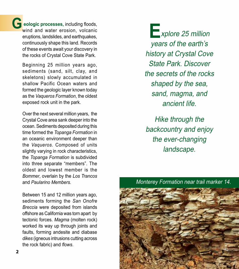
G eologic processes, including floods, wind and water erosion, volcanic eruptions, landslides, and earthquakes, continuously shape this land. Records of these events await your discovery in the rocks of Crystal Cove State Park.
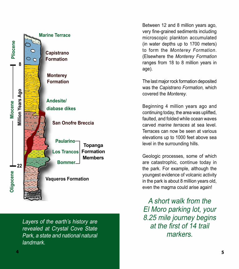
Beginning 25 million years ago, sediments (sand, silt, clay, and skeletons) slowly accumulated in shallow Pacific Ocean waters and formed the geologic layer known today as the Vaqueros Formation, the oldest exposed rock unit in the park.
Over the next several million years, the Crystal Cove area sank deeper into the ocean. Sediments deposited during this time formed the Topanga Formation in an oceanic environment deeper than the Vaqueros. Composed of units slightly varying in rock characteristics, the Topanga Formation is subdivided into three separate “members”. The oldest and lowest member is the Bommer, overlain by the Los Trancos and Paularino Members.
Between 15 and 12 million years ago, sediments forming the San Onofre Breccia were deposited from islands offshore as California was torn apart by tectonic forces. Magma (molten rock) worked its way up through joints and faults, forming andesite and diabase dikes (igneous intrusions cutting across the rock fabric) and flows.
Monterey Formation near trail marker 14.
2 3
Marine Terrace
Capistrano Formation
Andesite/diabase dikes
San Onofre Breccia
Paularino
Los Trancos
Bommer
8
22
Mill
ion
Year
s Ag
oO
ligoc
ene
Mio
cene
Plio
cene
Topanga Formation Members
Vaqueros Formation
Monterey Formation
Between 12 and 8 million years ago, very fine-grained sediments including microscopic plankton accumulated (in water depths up to 1700 meters) to form the Monterey Formation. (Elsewhere the Monterey Formation ranges from 18 to 8 million years in age).
The last major rock formation deposited was the Capistrano Formation, which covered the Monterey.
Beginning 4 million years ago and continuing today, the area was uplifted, faulted, and folded while ocean waves carved marine terraces at sea level. Terraces can now be seen at various elevations up to 1000 feet above sea level in the surrounding hills.
Geologic processes, some of which are catastrophic, continue today in the park. For example, although the youngest evidence of volcanic activity in the park is about 8 million years old, even the magma could arise again!
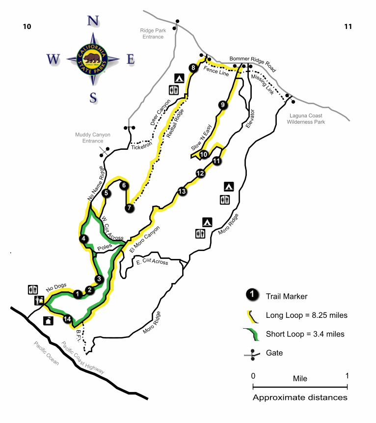
A short walk from the El Moro parking lot, your 8.25 mile journey begins
at the first of 14 trail markers.
Layers of the earth’s history are revealed at Crystal Cove State Park, a state and national natural landmark.
4 5
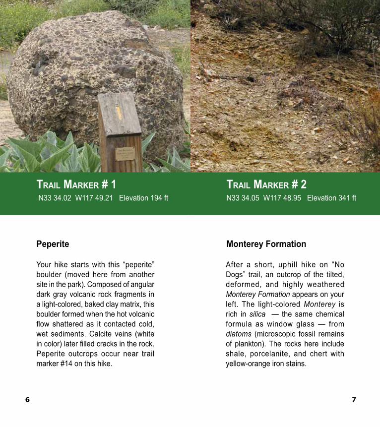
Your hike starts with this “peperite” boulder (moved here from another site in the park). Composed of angular dark gray volcanic rock fragments in a light-colored, baked clay matrix, this boulder formed when the hot volcanic flow shattered as it contacted cold, wet sediments. Calcite veins (white in color) later filled cracks in the rock. Peperite outcrops occur near trail marker #14 on this hike.
After a short, uphill hike on “No Dogs” trail, an outcrop of the tilted, deformed, and highly weathered Monterey Formation appears on your left. The light-colored Monterey is rich in silica — the same chemical formula as window glass — from diatoms (microscopic fossil remains of plankton). The rocks here include shale, porcelanite, and chert with yellow-orange iron stains.
Trail Marker # 1 N33 34.02 W117 49.21 Elevation 194 ft
Peperite
Trail Marker # 2 N33 34.05 W117 48.95 Elevation 341 ft
Monterey Formation
6 7
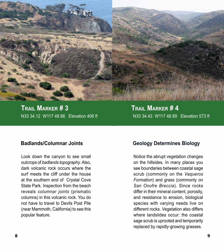
Look down the canyon to see small outcrops of badlands topography. Also, dark volcanic rock occurs where the surf meets the cliff under the house at the southern end of Crystal Cove State Park. Inspection from the beach reveals columnar joints (prismatic columns) in this volcanic rock. You do not have to travel to Devils Post Pile (near Mammoth, California) to see this popular feature.
Notice the abrupt vegetation changes on the hillsides. In many places you see boundaries between coastal sage scrub (commonly on the Vaqueros Formation) and grass (commonly on San Onofre Breccia). Since rocks differ in their mineral content, porosity, and resistance to erosion, biological species with varying needs live on different rocks. Vegetation also differs where landslides occur: the coastal sage scrub is uprooted and temporarily replaced by rapidly-growing grasses.
Trail Marker # 3 N33 34.12 W117 48.86 Elevation 406 ft
Badlands/Columnar Joints
Trail Marker # 4 N33 34.43 W117 48.89 Elevation 573 ft
Geology Determines Biology
8 9
Mile
Approximate distances
W. Cu
t Ac ross
No N
ame
Ri d
ge
No Dogs
Pacific Ocean
1
Trail Marker
Long Loop = 8.25 miles
Short Loop = 3.4 miles
Gate
10 11
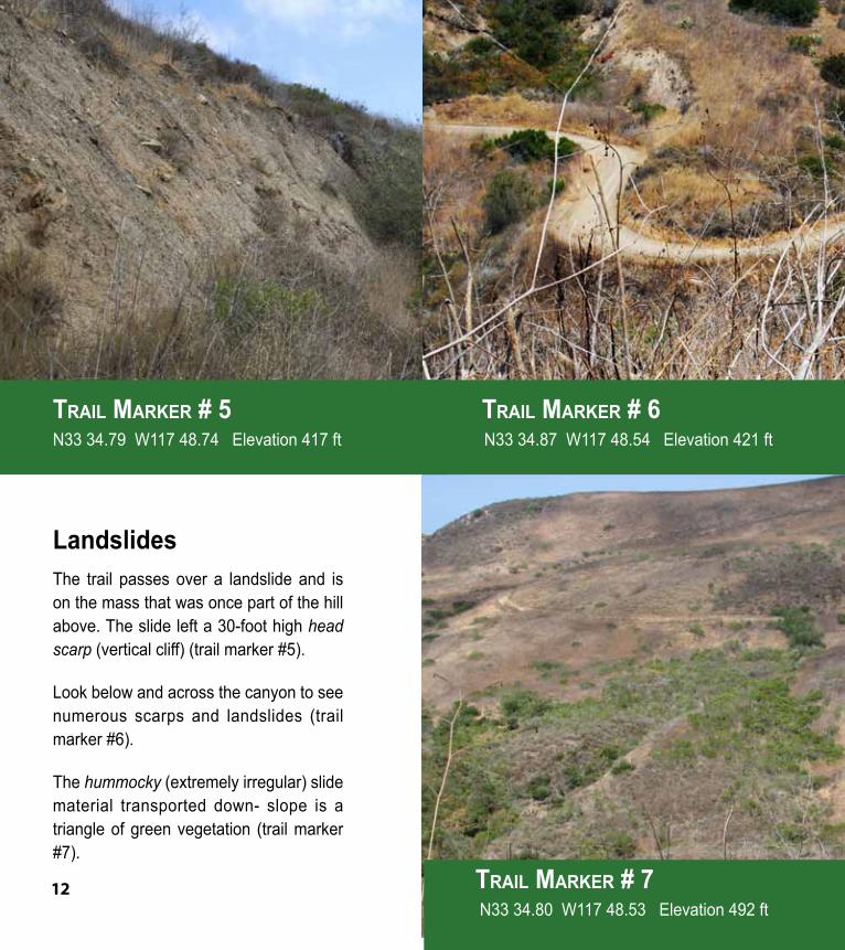
The trail passes over a landslide and is on the mass that was once part of the hill above. The slide left a 30-foot high head scarp (vertical cliff) (trail marker #5).
Look below and across the canyon to see numerous scarps and landslides (trail marker #6).
The hummocky (extremely irregular) slide material transported down- slope is a triangle of green vegetation (trail marker #7).
Trail Marker # 5 N33 34.79 W117 48.74 Elevation 417 ft
Landslides
Trail Marker # 6 N33 34.87 W117 48.54 Elevation 421 ft
Trail Marker # 7 N33 34.80 W117 48.53 Elevation 492 ft
12
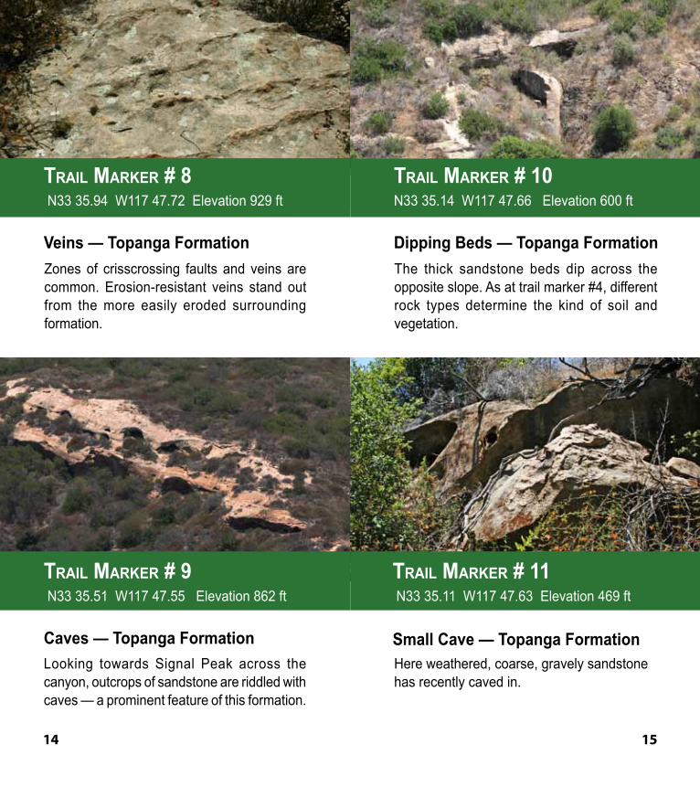
Zones of crisscrossing faults and veins are common. Erosion-resistant veins stand out from the more easily eroded surrounding formation.
Looking towards Signal Peak across the canyon, outcrops of sandstone are riddled with caves — a prominent feature of this formation.
The thick sandstone beds dip across the opposite slope. As at trail marker #4, different rock types determine the kind of soil and vegetation.
Here weathered, coarse, gravely sandstone has recently caved in.
Trail Marker # 8 N33 35.94 W117 47.72 Elevation 929 ft
Veins — Topanga Formation
Trail Marker # 10 N33 35.14 W117 47.66 Elevation 600 ft
Dipping Beds — Topanga Formation
Trail Marker # 9 N33 35.51 W117 47.55 Elevation 862 ft
Caves — Topanga Formation
Trail Marker # 11 N33 35.11 W117 47.63 Elevation 469 ft
Small Cave — Topanga Formation
14 15
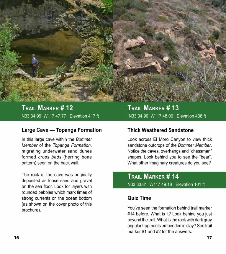
In this large cave within the Bommer Member of the Topanga Formation, migrating underwater sand dunes formed cross beds (herring bone pattern) seen on the back wall.
The rock of the cave was originally deposited as loose sand and gravel on the sea floor. Look for layers with rounded pebbles which mark times of strong currents on the ocean bottom (as shown on the cover photo of this brochure).
Look across El Moro Canyon to view thick sandstone outcrops of the Bommer Member. Notice the caves, overhangs and “chessman” shapes. Look behind you to see the “bear”. What other imaginary creatures do you see?
You’ve seen the formation behind trail marker #14 before. What is it? Look behind you just beyond the trail. What is the rock with dark gray angular fragments embedded in clay? See trail marker #1 and #2 for the answers.
Trail Marker # 12 N33 34.99 W117 47.77 Elevation 417 ft
Large Cave — Topanga Formation
Trail Marker # 13 N33 34.90 W117 48.00 Elevation 438 ft
Thick Weathered Sandstone
Trail Marker # 14N33 33.81 W117 49.18 Elevation 101 ft
Quiz Time
16 17
To further explore Orange County geology, visit:Crystal Cove State Park Calendar www.crystalcovestatepark.com
Merton Hill, PhD at Saddleback College www.saddleback.edu/faculty/mhill
Laguna Canyon Foundation www.lagunacanyon.org/events.html
Irvine Ranch Natural Landmarks www.irvineranchwildlands.org
Please remember• Be prepared. Pack plenty of water, snacks,
sunscreen, and other backcountry essentials.• Please protect your park. Enjoy only trails
designated by park maps and signs.• Camping reservations are required.
The following are prohibited:• collection of rocks, fossils, plants, seeds,
animals, or shells. • smoking or open fire pits in the El Moro
backcountry.• dogs on the beach or in the backcountry.
This guide was made possible by contributions from:Merton Hill, PhD, Saddleback College;
Rick Behl, PhD,California State University, Long Beach; and
Tod Brewster, Eagle Scout,Orange County Troop 567.
Images by:Annlia Hill, PhD; Merton Hill, PhD; and California State Parks.
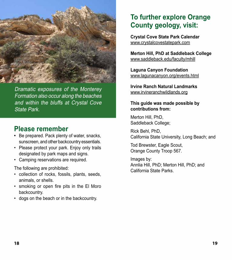
Dramatic exposures of the Monterey Formation also occur along the beaches and within the bluffs at Crystal Cove State Park.
18 19
Our MissionThe mission of California State Parks is to provide for the health, inspiration and education of the people of California by helping to preserve the state’s extraordinary biological diversity, protecting its most valued natural and cultural resources, and creating opportunities for high-quality outdoor recreation.
CRYSTAL COVE STATE PARk8471PacificCoastHwy
Laguna Beach, CA 92651(949) 494-3539
www.parks.ca.gov
California State Parks supports equal access. Prior to arrival, visitors with
disabilities who need assistance should contact Crystal Cove State
Park at (949) 494-3539,711, TTY Relay Service. This
publication is available in alternate formats by contacting:
CALIFORNIA STATE PARKSOrange Coast District
3030 Avenida del PresidenteSan Clemente, CA 92672
(949) 366-8503
© 2009 California State Parks