geology and mineral resources of rajasthan
140
Published by order of the Government of India 2011 Published by order of the Government of India 2011 GEOLOGICAL SURVEY OF INDIA GEOLOGICAL SURVEY OF INDIA Miscellanceous Publication Miscellanceous Publication No. 30 Part 12 • 3rd Revised Edition No. 30 Part 12 • 3rd Revised Edition • • YEARS YEARS in the service of the nation (1851-2011) in the service of the nation (1851-2011) ISSN 0579-4706 PGSI. 327 700-2010 (DSK-II) © Govt. of India Controller of Publication GEOLOGY MINERAL RESOURCES RAJASTHAN AND OF GEOLOGY AND MINERAL RESOURCES OF RAJASTHAN GEOLOGY MINERAL RESOURCES RAJASTHAN AND OF GEOLOGY AND MINERAL RESOURCES OF RAJASTHAN
Transcript of geology and mineral resources of rajasthan

Published by order of the Government of India
2011
Published by order of the Government of India
2011
GEOLOGICAL SURVEY OF INDIAGEOLOGICAL SURVEY OF INDIAMiscellanceous PublicationMiscellanceous Publication
No. 30 Part 12 • 3rd Revised Edition No. 30 Part 12 • 3rd Revised Edition
••YEARSYEARS
in the service of the nation(1851-2011)
in the service of the nation(1851-2011)
ISSN 0579-4706PGSI. 327
700-2010 (DSK-II)
© Govt. of IndiaController of Publication
GEOLOGY
MINERAL RESOURCES
RAJASTHAN
AND
OF
GEOLOGY AND
MINERAL RESOURCESOF
RAJASTHAN
GEOLOGY
MINERAL RESOURCES
RAJASTHAN
AND
OF
GEOLOGY AND
MINERAL RESOURCESOF
RAJASTHAN
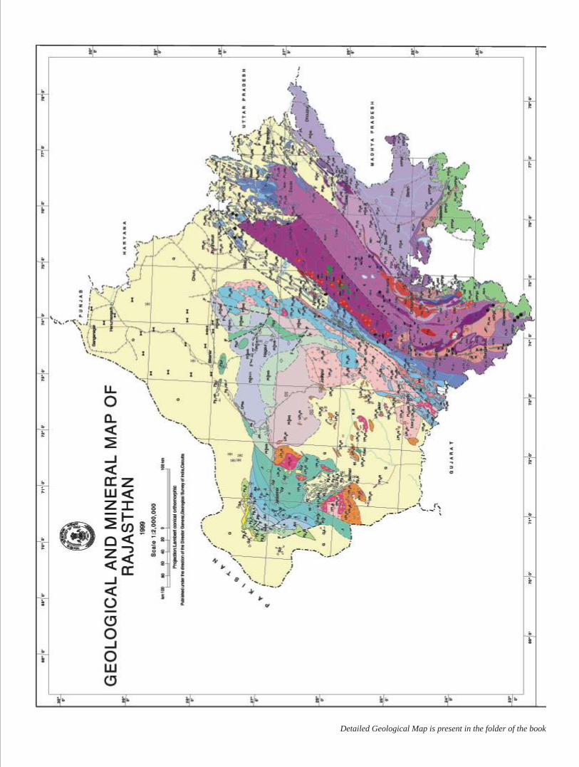
Detailed Geological Map is present in the folder of the book
ISSN 0579-4706
Published by order of the Government of India
2011
GEOLOGY AND
MINERAL RESOURCESOF
RAJASTHAN
GEOLOGICAL SURVEY OF INDIAMiscellaneous Publication
No. 30 Part 12 • 3rd Revised Edition
•YEARS
in the service of the nation(1851-2011)
PGSI. 327
700-2010 (DSK-II)
© Govt. of IndiaController of Publication
Inland : 265.00Foreign : 9.00, US $ 15.00, EURO € 10.00
ANIL KUMAR and P. RAKSHITDirectors
Printed in India at POPULAR PRINTERS, Fateh Tiba Marg, Moti Doongri Road, Jaipur
Published by the DIRECTOR GENERAL, Geological Survey of India,27, Jawaharlal Nehru Road, Kolkata 700016
RAJENDER K. AGGARWAL, ARCHANA SHARMA and SHABBIR HUSSAIN
Senior Geologists
(1998)
• First Published 1977• Second Edition 2001• Reprint (Second Edition) 2007• Third Edition 2011
2nd edition compiled by P. Shrivastava, Senior GeologistSubsequently revised by the Geologists of Western Region with
overall supervision of P. Gupta and G. Malhotra, Directors
GEOLOGICAL SURVEY OF INDIA
he state of Rajasthan is endowed with a storehouse of mineral deposits of copper, lead, zinc, gold, tungsten, potash, lignite, mica, graphite and many non-metallic Tminerals and dimensional stones. Concerted efforts of GSI over the last few decades
had resulted in augmenting the mineral resources position of Rajasthan to several folds. The knowledge on the Geology of the state of Rajasthan has undergone substantial upgradation as a result of recent works. GSI has been updating the knowledge through its publications viz. records, memoirs, bulletins and mineral atlases as well as in the form of unpublished reports. The third revised edition of Miscellaneous Publication Number 30, Part 12 covering Geology and Mineral resources of Rajasthan has been thoroughly revised incorporating the data gathered during the recent past.
The urgent need in Earth Sciences is to update the data in terms of tectono-magmatic evolution of the area. In this Publication a comprehensive evolution of the geological set up of Rajasthan has been made incorporating the latest knowledge on the tectonic and metallogenic set up of the various domains and the mineral deposits have been described.
I believe that this write up would be of much help to the scientists, students and researchers at large in the field of earth sciences.
iii
Foreword
KolkataDecember, 2010
(Jaswant Singh)Director General
Geological Survey of India
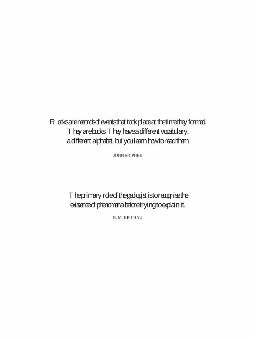
The primary role of the geologist is to recognise the
existence of phenomena before trying to explain it.
B. M. KEILHAU
Rocks are records of events that took place at the time they formed.
They are books. They have a different vocabulary,
a different alphabet, but you learn how to read them.
JOHN MCPHEE
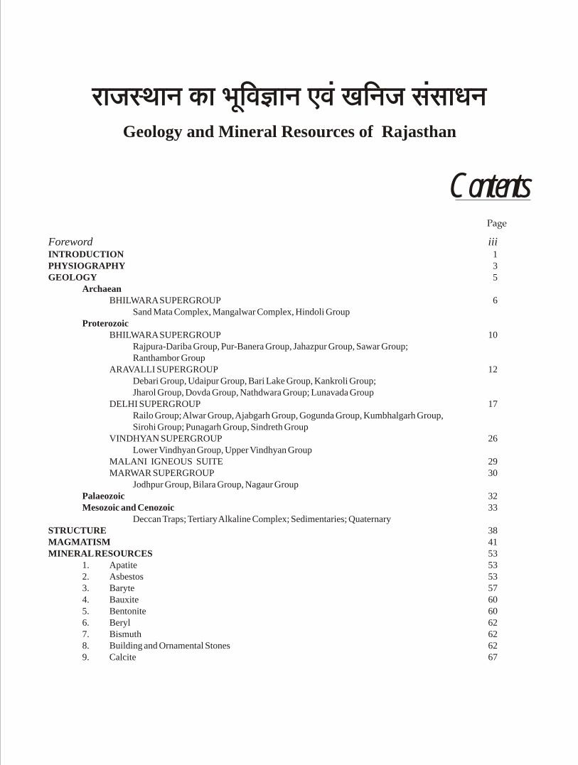
Contents
Foreword iiiINTRODUCTION 1PHYSIOGRAPHY 3GEOLOGY 5
ArchaeanBHILWARA SUPERGROUP 6
Sand Mata Complex, Mangalwar Complex, Hindoli GroupProterozoic
BHILWARA SUPERGROUP 10Rajpura-Dariba Group, Pur-Banera Group, Jahazpur Group, Sawar Group;Ranthambor Group
ARAVALLI SUPERGROUP 12Debari Group, Udaipur Group, Bari Lake Group, Kankroli Group;Jharol Group, Dovda Group, Nathdwara Group; Lunavada Group
DELHI SUPERGROUP 17Railo Group; Alwar Group, Ajabgarh Group, Gogunda Group, Kumbhalgarh Group,Sirohi Group; Punagarh Group, Sindreth Group
VINDHYAN SUPERGROUP 26Lower Vindhyan Group, Upper Vindhyan Group
MALANI IGNEOUS SUITE 29MARWAR SUPERGROUP 30
Jodhpur Group, Bilara Group, Nagaur GroupPalaeozoic 32Mesozoic and Cenozoic 33
Deccan Traps; Tertiary Alkaline Complex; Sedimentaries; QuaternarySTRUCTURE 38MAGMATISM 41MINERAL RESOURCES 53
1. Apatite 532. Asbestos 533. Baryte 574. Bauxite 605. Bentonite 606. Beryl 627. Bismuth 628. Building and Ornamental Stones 629. Calcite 67
Geology and Mineral Resources of Rajasthan
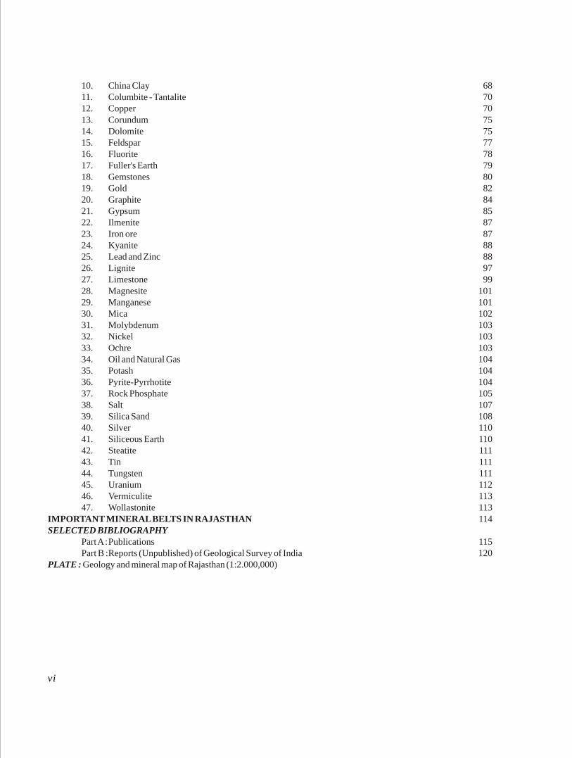
10. China Clay 6811. Columbite - Tantalite 7012. Copper 7013. Corundum 7514. Dolomite 7515. Feldspar 7716. Fluorite 7817. Fuller's Earth 7918. Gemstones 8019. Gold 8220. Graphite 8421. Gypsum 8522. Ilmenite 8723. Iron ore 8724. Kyanite 8825. Lead and Zinc 8826. Lignite 9727. Limestone 9928. Magnesite 10129. Manganese 10130. Mica 10231. Molybdenum 10332. Nickel 10333. Ochre 10334. Oil and Natural Gas 10435. Potash 10436. Pyrite-Pyrrhotite 10437. Rock Phosphate 10538. Salt 10739. Silica Sand 10840. Silver 11041. Siliceous Earth 11042. Steatite 11143. Tin 11144. Tungsten 11145. Uranium 11246. Vermiculite 11347. Wollastonite 113
IMPORTANT MINERAL BELTS IN RAJASTHAN 114SELECTED BIBLIOGRAPHY
Part A :Publications 115Part B :Reports (Unpublished) of Geological Survey of India 120
PLATE : Geology and mineral map of Rajasthan (1:2.000,000)
vi
The Rajasthan State, earlier known as Rajputana came into existence on March 30, 1949. It occupies 3,42,239 sq km area covering 10.74% of the Indian Territory and is the largest State of India. The State is
o o o olocated within 23 03'-30 12'N and 69 29'-78 17'E and bounded on the west and northwest by Pakistan, on the north and northeast by Haryana and Uttar Pradesh and on the south-southeast and southwest by Madhya Pradesh and Gujarat States respectively. The north-western part of the State is occupied by the Thar Desert covering 32% area of the total area. The Aravalli hill range extending from Delhi in the northeast to the plains of north Gujarat in the southwest, divides the State into two unequal parts. The area to the east of the hills is covered by the eastern plains and the Vindhyan plateau.
Rajasthan forms north-western part of the Indian Shield. The rock sequences of the region cover a time span of about 3500 to 0.5 Ma. The State exposes a variety of lithological and tectonic units ranging in age from Archaean to Recent times. The basement rocks - the Sandmata Complex, Mangalwar Complex and Hindoli Group of Bhilwara Supergroup - occupy central and south-eastern plains. They are Archaean in age and comprise in general, granulite-gneiss; amphibolite, metapelite, paragneiss, calc-silicate rocks and greywacke (the older granite-greenstone belt) and metavolcanic, metagreywacke (the younger granite-greenstone belt) respectively.
The Lower Proterozoic supracrustal rocks of the Jahazpur, Rajpura-Dariba, Pur-Banera and Sawar Groups of Bhilwara Supergroup rest on the basement rocks of the Mangalwar Complex and host a number of lead, zinc and copper deposits. The Bhilwara Supergroup of rocks is intruded by the Untala-Gingla Granite, Berach Granite, basic and ultramafic bodies.
The Proterozoic fold belts, viz., the Aravalli fold
belt (the Aravalli Supergroup) and the Delhi fold belt (the Delhi Supergroup) occupy the southern and south-eastern, and south-western and north-eastern Rajasthan respectively. The Aravalli Supergroup is represented by metamorphosed and complexly folded clastic sediments with minor chemogenic and organogenic assemblages with interlayered basic volcancics, whereas the Delhi Supergroup comprises mainly carbonates, metavolcanics, metasammites and metapelites, intruded by magmatic rock of Phulad Ophiolite Suite and syn-orogenic granites of Sendra-Ambaji, Bairath, Dadikar, Harsora, etc. A number of base metal deposits are located in these belts as also other minerals.
The isolated hillocks of western Rajasthan constitute the Upper Proterozoic Malani Igneous Suite and the Erinpura Granite pluton. Eastern Rajasthan is characterised by the vast sedimentary stretch constituting the Vindhyans, which is juxtaposed against the rocks of the Bhilwara Supergroup along the Great Boundary Fault.
The northern and north-western parts of the State exhibit Upper Proterozoic-Early Cambrian (?) rocks of the Marwar Supergroup which are overlain by sedimentary rocks of different ages of Palaeozoic and Mesozoic Era. Many industrial mineral deposits are found in these rocks. The Deccan Traps are restricted to the south-eastern part of the State in Chittaurgarh-Banswara area. The Cenozoic rocks are manifested in Barmer and Jaisalmer basins in the west and Ganganagar-Palana shelf in the north. The Quaternary sediments of aeolian and fluvial origin constitute the Thar Desert of Rajasthan.
The geological investigations have been continuingin the state for more than a century. However, there are some problems which need to be resolved. Scientific
Introduction
1
GEOL, SURV. IND.2
efforts are on to unravel such geological complexities.
Recent investigations have brought out important
mineral deposits in the State. To list, a few are : the lead-*zinc deposits of Agucha and Pur-Banera in Bhilwara
district, Kayar-Gugra deposit in Ajmer district, Dariba-
Rajpura-Bethumbi deposit in Rajsamand district; gold
in Jagpura-Bhukia belt in Banswara district; limestone
in Jaisalmer and Chittaurgarh districts; potash in Ganganagar-Nagaur basin etc.
The present write-up gives a succinct account of geology of Rajasthan and details of mineral repositories of the State. This document has been
†compiled from the work carried out by the officers of Geological Survey of India for over nine decades.
Chowdhury, A.K. Mathur, A.K. Sharma, M. Mohanty, G. Malhotra, L.S. Shekhawat, S.N. Bhattacharaya, S.K. Bohra, S.K. Wadhawan, B. Sural, R.M. Sundaram, N.K. Pal, A. Chaturvedi, K.C. Sahu, S.N. Patel, G.P. Gupta, S. Prasad, K.P. Varma, C.J. Kumanan and B.B. Sharma were engaged in mapping different parts of Rajasthan on modern toposheets and also took up revision mapping in some of mineralized belts. First generation mapping of Rajasthan was, thus, completed by 1989-90.
Workers who carried out detailed exploration for base metals in Rajasthan during 1952-90 includes Muktinath, C.S. Raja Rao, V.K.S. Varadan, M. Narasimhan, A.K. Banerjee, W.K. Natarajan, B.C. Poddar, R.K. Mathur, A.L. Mathur, B. Kakoti, V.D. Chande, M.K. Hore, K.R. Raghunandan, R.C. Jog, V.S. Bapna, A.S. Ramaiengar, G.H.S.V.P. Rao, G.V. Devapriyan, R.S. Jain, V. Venkatesh, K. Ganeshan; B. Koti Reddy C.L. Harpavat, S.K. Roy, R.S. Jamwal, U. Samaddar, Ram Chandra, M.S. Jairam, R.N. Singh, S.P. Misra, J.L. Narang, R.S. Goyal S.C. Kaura, S.P. Ghosh, J. Bhattacharjee, Eshwara, S.M. Saxena, G.K. Pancholi, T.K. Biswal, V.K. Khullar, Binod Kumar, D. Kothiyal, R.C. Tyagi, Kashi Ram, B. Chattopadhyay, A.K. Mukhopadhyay, R.K. Singhai and T.P. Upadhyay. The work on phosphorites was taken up by B. Srikantan, V.N. Sant, S.N. Tarafdar, S.L. Mehra and G.P. Deshmukh (1966-1970), and B. Dayal, V.K.K. Kalluraya, A.P. Sinha and A.K. Malhotra (1970-80).
Since 1990 the GSI has been carrying out second generation mapping, specialized thematic mapping, transect mapping and concept oriented mineral explorations covering some parts of the State. These studies have brought out new concepts which are yet to be established on a regional basis, and therefore have not been included in the present write-up though cited in the bibliography. The officers associated with mapping projects were: V. Aneel Kumar, A. Rai Chowdhary, B. Chakrabarti, Kakali Jana, T.K. Jana, V.K. Chittora, R.K. Sharma, S. Mukhopadhyaya, L.M.S. Maura, S. Sanyal, Ram Jivan Singh, J.C. Dutta, S. Dutta, S.S. Sivasankaran, V.P. Sharma, K.S. Raghav, C.K. Gautam and Suresh Pareek. The officers who carried out mineral investigations were : S.S. Ameta, Ramjee, L.D. Gaikwad, R.C. Mishra, P.K. Yadav, S. Das Gupta, P.N. Sharma, Chandra Madhav, R.P. Nagar, S.S. Garhia, D.K. Bhattacharya, P.S. Gill, L.N. Singh, S.K. Singh, S.L. Singh, S. Banerji, Brij Kumar, R.A. Sharma, P.R. Golani, Shyam Narain, C.R. Saha, R.S. Rajawat, N.K. Sood, N.K. Sahiwala, D.J. Das Gupta, Shabbir Hussain, K. Nagarajan, N.N. Chaudhuri, A.K. Grover, R.G. Verma, R.K. Vishnoi, I.J. Qureshi, R.S. Garkhal, Jaya Lal, R.L. Jat, A. Cheilletz, Krishan Dutt, S.S. Sarkar, A.B. Reddy and V.S. Murthy.
†The pioneering geological work in different parts of the State in the 19th century has been of W.D. Blanford, C.A. Hacket, T.H.D. La Touche, F.R. Mallet, C.A. Mc. Mahon, H.B. Medlicott, R.D. Oldham and H. Warth. Among the notable earlier workers who mapped almost the entire State, during the period from 1914 to 1933 were A.M. Heron, A.L. Coulson, B.C. Gupta, S.K. Chatterjee, J.B. Auden, P.K. Ghosh, P.N. Mukherjee and V.P. Sondhi. After Indian Independence, mapping and assessment of mineral resources of Ajmer district were carried out mainly by C. Karunakaran, T.K. Kurien, Kedar Narain and V.R. Venkoba Rao between 1948 and 55. The systematic mapping on modern lines and studies on tectonics and mineral resources including detailed exploration by drilling in different districts, were carried out by a number of geologists in different areas. B. Srikantan, V.N. Sant and S.B. Sharma (1952-1966) mapped a major part of Alwar and Jaipur districts. S.P. Das Gupta (1953-58) completed detailed mapping of the Khetri Copper Belt. The adjoining areas near Neem-ka-Thana were mapped by M.L. Jhanwar, O.P. Mathur and M.L. Bhat (1964-70). The mapping in Ajmer, Alwar, Bharatpur, Bundi, Bhilwara, Banswara, Chittaurgarh, Dungarpur, Jaipur, Jaisalmer, Kota, Pali, Sirohi, Tonk and Udaipur districts was carried out during 1958-81 by K.K. Basu, B.S. Manjrekar, S.N. Gupta, Y.K. Arora, R.P. Srivastava, B.D. Gupta, T.N. Sahai, R.K. Mathur, L.N. Dutta, V.D. Mahajan, Balmiki Prasad, Iqbaluddin, S.C. Kapoor, K.K. Mukherjee, S. Das Gupta, G.J. Chandak, N.B. Bhattacharayya, Shiv Poojan Misra, N.P. Chaudhury, A.M. Rakshit, S.M. Banerjee, N. Chattopadhyay, K.R. Ramachandran, B. Mukerji, N. Krishnamurthy, S.S. Jain, R.P.S. Pahuja, R.L Munshi, U.S.N. Reddy, C. Ram Mohana, S.R. Sengupta, B.J.C. Gupta, Ram Lal Garg, S.K. Sinha, S.K. Bhushan, M.R. Madhav Rao, P.C. Bakliwal, H.J. Maharaja Singh, V. Murlidharan, M.P. Muraleedharan, R. Ravindra, A.R. Das, S.P. Singh, P.K. Chaurasia, S.K. Basu, G. Ramalingam, A. Bandhopadhyay, T.K. Pyne, V.K.K. Kalluraya and B.L. Narsayya. P.C. Sogani and E.A. Khan during 1963-71 carried out the mapping of major part of the Marwar Supergroup (Trans-Aravalli Vindhyans) covering Pali, Jodhpur and Nagaur districts. Besides, a large number of geologists namely S. Adhikari, A.K. Chattopadhyay, M.P. Chawade, V.P. Laul, S.M. Ramasamy, Virendra Kumar, J.N. Ray, S. Adhikari, P. Gupta, Vikram Rai, Z. Iqbal, K.S. Mishra, K. Mazumdar, N.H. Faruqui, Fareeduddin, R. Shukla, S.V. Raghupathi Rao, S.S. Ghosh, R.C. Gathania, I.V. Reddy, P.S. Bhatnagar, V. Chandrasekaran, S.K. Mitra, D.K. Rai, R. Srivastava, L.N. Mathur, G.N. Pal, I.R. Kirmani, P. Sarkar, S.S. Shrivastava, S. Ghosh, R.K. Sinha, Vimal Kumar, B.D. Thapa, S.K. Jadia, B.V. R. Reddy, M.S. Reddy, R.L. Sahu, S. Chaudhary, S.K. Mishra, P. Shrivastava, A.K. Saxena, D. B. Guha, S.A. Chore, K. Mukhopadhyay, I.
* established by the DGM, Rajasthan
* * * *
Physiographically, Rajasthan is divided into four regions, bearing a close relationship with the geological history of the State, viz., (i) Western desert plains, (ii) Aravalli mountain range, (iii) Eastern plains and (iv) Vindhyan plateau.
The western desert plain is a sandy desolate expanse of dune fields and rocky pavements. The plain, lying to the west of Aravalli hills, covers 1,75,000 sq km area of the Rajasthan. It is affected by scanty rainfall. The Luni and Sukri rivers, ephemerally flowing in a southwesterly direction, form the main drainage of the area. A large part of western Rajasthan is characterised by its inland drainage and carries some of the largest salt-lakes, viz., the Sambhar, Didwana, Kuchaman and Talchapar lakes.
The Aravalli hills of Rajasthan traverse the State in a NNE-SSW direction almost from end to end dividing Rajasthan in two unequal parts, three-fifth of which constitutes the western Rajasthan, two-fifth constituting the eastern Rajasthan. The Aravalli mountain range which exposes principally rocks of the Delhi Supergroup comprises alternating hill ranges and valleys extending from Delhi on the NE to the plains of north Gujarat on the SW for a distance of about 650 km. The entire hill range can broadly be divided into : (i) The north-eastern hill range to the northwest of Jaipur district with an average height of 550-650 m (Alwar hills) and intermittent wide valleys; (ii) The central Aravalli hill range comprising hills of Shekhawati and Marwar region with an average height of 400 m (Shekhawati hills); (iii) The Mewar hills covering the area of Udaipur, Dungarpur and Sirohi districts with the relief varying from a plateau between
Kumbhalgarh and Gogunda to uniformly rolling country on the south-central part and (iv) The Mt. Abu hill range, with an average 1,200 m height, constituted by the Abu batholith of the Erinpura Granite. The highest peak called Guru Shikhar, 1,727 m above MSL, is situated on the Mount Abu. The Aravalli range partly forms one of the main watersheds of India, which divides drainage to the Bay of Bengal from the Arabian Sea. Ajmer city, lying almost at the centre of the range, is in fact on a tri-junction of the watershed. The watershed passes along the centre of the range from Ajmer to the southwest up to Kumbhalgarh where it swings to the southeast for some distance to pass ultimately through Udaipur. South of Udaipur, the drainage is to the south into the Gulf of Cambay through the Sabarmati river. The streams emanating from the north and northeast of Udaipur flow into the Banas river through its tributaries. The Sahibi river drains the northern parts of the State and ultimately disappears in the plains of Haryana State. The Banganga river drains the areas in Alwar and Jaipur districts and flows through a large part of Bharatpur district, before joining the Jamuna river.
The Eastern plains occur to the northeast, east and southeast of the Aravalli range. The plains cover about 23% area of the Rajasthan. Its northern boundary meets with the Gangetic plains in Bharatpur district; whereas the south-eastern boundary lies in contact with the Vindhyan Supergroup. Three major basins viz., the Chambal basin, Banas basin and Mahi basin comprise the plains. It constitutes a vast undulating, pediplained country occupied by the gneisses and schists of the Banded Gneissic Complex as well as the phyllites
Physiography
3
GEOL, SURV. IND.4
and other rocks of the Aravalli Supergroup. The terrain is covered by a thick mantle of alluvium and wind-blown sand.
The Vindhyan Supergroup in the southeast, is constituted by alternating sequences of sandstone, shale and limestone, forms the western extremity of the main Vindhyan basin. The Vindhyans in this area comprise three groups-the Bhander Group to the northeast, followed by the Rewa Group to the south and west, and the Kaimur Group encircling the Rewa and Bhander Group. The Deccan Traps plateau, further south, continues in Madhya Pradesh. The junction between the Vindhyan Supergroup and the Eastern plains of Rajasthan is marked by the Great Boundary Fault (GBF). The drainage in this part of Rajasthan is generally to the
north and northeast. The Berach river which drains the south-western parts of the Vindhyans, runs northwards, turns to the northeast and flows parallel to and on the northern side of the GBF The Berach river flows into the Banas river which joins the Chambal river in Dholpur area. Elsewhere the rivers and streams flow in different directions and join the Chambal river which flows in a northeasterly direction parallel to the GBF through Kota. The Chambal river draining into the Jamuna river in Uttar Pradesh is the only perennial river in the State.
The rainfall in the Aravalli hill range and further to the east is moderate (150 cm per year). But, to the west of the Aravalli range the rainfall is scanty and sporadic.
Indian Precambrian Shield is an assembly of more than one Archaean cratonic nuclei that amalgamated during late Archaean - early Proterozoic time. This amalgamated Indian Precambrian crust could be divided into geologically well defined geographical parts separated by some fundamental crustal dislocations and/or vast expanses of Phanerozoic rocks. One such part is the Western Indian Shield covering the states of Rajasthan and Gujarat. The Rajasthan state, encompassing an area of 3,42,239 sq km bounded by latitude 23º 03'N to 30º 12'N and longitude 69º 29'E to 78º 17'E, exposes rock sequences ranging in age from Archaean to Recent times. The Western Indian Shield can be conveniently sub-divided into Provinces on the basis of distinct lithological, structural, metamorphic, geochemical characteristics and geochronology. Shears/fault zones mark the boundaries and join the Provinces. The different provinces of the Western Indian Shield from east to west are the BGC Province, the Aravalli-Delhi Province and the Trans-Aravalli Province.
The oldest cratonic nucleus of the Western Indian Shield, familiarly known as the Banded Gneissic Complex (BGC), occupies a large tract in the Mewar plains of south and east Rajasthan and forms a major component of the BGC Province. It is skirted on the west and southwest by Proterozoic fold belts of the Aravalli and the Delhi Supergroups (forming the Aravalli-Delhi Province), and an arcuate belt of low grade metamorphosed volcano-sedimentaries (erstwhile Gwalior Series of Heron, 1953; Eastern Aravalli Belt of Gupta, 1934; and Hindoli-Jahazpur Groups of Gupta et al. 1980) and Vindhyan platformal sediments (Upper Proterozoic) demarcate the eastern boundary of this craton. Besides, a Deccan Trap cover delimits the southern boundary of its outcrop area. The BGC forms the basement for a number of synformal basins hosting metasedimentary/metavolcano-
sedimentary rock sequences of early Proterozoic age like those of Gangwara, Sawar, Bharak-Parasoli-Shriramnagar and Rajpura-Dariba.
The Aravalli-Delhi Province is composed of Proterozoic supracrustals sequences classified at the Aravalli Supergroups (early Proterozoic) and Delhi Supergroup (early to middle Proterozoic). Metamorphic and structural parameters backed up by geochronological data have clearly demonstrated that the BGC was a crystalline basement upon which the rocks of the Proterozoic Aravalli and Delhi Supergroups were deposited. Besides, evidences of an unconformity between the BGC and the overlying supracrustals suites have been widely proposed. The Delhi Supergroup occurs in the form of two distinct fold belts, i.e., the North Delhi Fold Belt (NDFB) in Alwar, Dausa, Jaipur, Bharatpur, Sikar and Jhunjhunu districts and the South Delhi Fold Belt (SDFB) in Ajmer, Pali, Rajsamand, Udaipur and Sirohi distrcits.
The Trans-Aravalli Province encompasses the area west of the Aravalli Mountains. Late Proterozoic igneous and sedimentary rock assemblages, grouped under the Malani Igneous Suite alongwith crystallines of Archaean age (equivalent of the BGC) and the Marwar Supergroup occupy a large part of the Trans-Aravalli Province. The Malani and the Marwar rocks are not deformed and, therefore, the episodes of the Precambrian magmatism/sedimentation in this part of the Western Indian shield are post-tectonic (anorogenic phenomenon).
The Late Proterozoic to Early Cambrain (?) Marwar Supergroup occupies the westernmost and northwestern parts of the State and comprises the Jodhpur Sandstone, Bilara dolomite-limestone, Hanseran evaporite sequence and the Nagaur sandstone, clay and Siltstone. These sequences overlie the basement constituted mainly by the Malani Igneous Suite. The rocks of the
Geology
5
Geology compiled by P. Gupta

GEOL, SURV. IND.6
Marwar Supergroup are unconformably overlain by the Bap Boulder Bed which forms the basement for the Badhaura Sandstone, the youngest Palaeozoic formation. The Mesozoic and the Cenozoic geological sequences are represented by sandstone, shale and limestone in Jaisalmer, Barmer and Palana basins and host Tertiary lignite, oil and natural gas.
The above rock sequences acted as repositories to several mineral deposits of economic importance, thereby, enlisting the state of Rajasthan as one of the leading mineral producing states in India (Table-8). Though mafic-ultamafic intrusives in shear zones or in zones of reactivation inevitably hold some promise, the high-grade rocks of the BGC are invariably devoid of important mineralisations. BGC contains vestiges of greenstone rocks engulfed in the succeeding granites and migmatites. These greenstone rocks contain copper and zinc and are bestowed with gold occurrences, the latter often in enriched forms in zones of high strain. The best known sulphide mineralisations, volcanogenic and sediment-hosted, are located in Proterozoic fold belts and in the intracratonic Proterozoic basins within the BGC and are related to extensional tectonics that led to the development of mostly abortive rift basins. Tin-tungsten mineralisations have been hosted by Proterozoic granites intruding the crystalline rocks of Archaean age (BGC equivalent rock) in the Trans-Aravalli Province and the Proterozoic SDFB. These alongwith the Proto-ophiolite associated basemetal sulphide deposits in the southwestern part of the SDFB reflect a process of convergent tectonics circumventing the oceanic crust.
BANDED GNEISSIC COMPLEX PROVINCE
The Precambrain rocks of Rajasthan were studied in the initial stages by Hacket (1881), Heron (1917, 1923, 1936 and 1953), Coulson (1927 and 1928) and Gupta (1934). Heron (1936, 1953) and Gupta (op.cit.) classified the Precambrain rocks of Rajasthan, “not counting the Bundelkhand Gneiss”, in the order of increasing antiquity as the Vindhyan 'System', Malani 'Series', Delhi 'System', Raialo 'Series', Aravalli 'System' and Banded Gneissic Complex (pre-Aravallies) “separated from one other by five clear erosional unconformities”.
Heron (1917, 1953) grouped the Aravalli 'System', the Banded Gneissic Complex and the Bundelkhand Gneiss with the Archaean. While geological information have firmly rooted the Aravalli Supergroup
in the early Proterozoic slot, the geochronological data moots that the Bundelkhand Gneiss in the Rajasthan part (renamed by Pascoe, 1950, as the Berach Granite) represents the terminal stage of magmatic activity of the Archaean orogeny in the late Archaean time.
Though controversy shrouds the BGC as a single Archaean unit, the antiquity of BGC gneisses is established beyond doubt. The Archaean basement status of the BGC is established from the existence of an unconformity between the BGC and the early Proterozoic Aravalli metasediments from southern Rajasthan, the presence of older crust in the provenance of the Aravalli metasediments (indicated from the Pb-Pb isochron age of ~3.5 ± 0.2 Ga of Zircon-rich schists from the Aravalli Supergroup), Sm-Nd isochron age of ~3.5 Ga for a composite suite of gneisses and amphibolites from the BGC near Udaipur, Sm-Nd isochrones equivalent to 3.31 ± 0.07 Ga and 2.89 ± 0.05 Ga respectively from tonalite to granodiorite and amphibolite from east of Udaipur and Nathdwara respectively and Rb-Sr isochron age of 2950 ± 150 Ma of Untala and Gingla Granites which intrude the biotite gneiss, amphibolites and paragneisses of the BGC. The BGC rocks underlying the Delhi metasediments in central and north-central Rajasthan have undergone polymetamorphism, a feature recognized as characteristic of BGC rocks. This is in sharp contrast to the low grade of metamorphism and intermediate pressure metamorphism inscribed in the Aravalli and Delhi rocks respectively.
BGC represents a cratonic nucleus made up of a heterogeneous assemblage of pre-Aravalli metasediments, migmatites, granites, metabasic rocks, pegmatites and aplite. The metasediments and the igneous rocks belong to multiple cycles and phases and are blended together into composite gneiss; the original precursor rock units, representing the plutonic, volcanic and sedimentary protoliths, are scarcely preserved as xenoliths, bands, streaks and patches. The BGC rocks are intruded by a number of generations of granitic plutons, the latter ranging in age from Archaean to middle Proterozoic. Broadly, in the BGC, the northern part is dominated by meta-sedimentary supracrustals with undifferentiated greenstone sequences and the southern part is prevailed over by distinct volcanic - dominated greenstone sequences within a milieu of granite gneisses with a supposed orthogenetic basement. Inadequacy of chronometric and other data is still a major hindrance to build a distinct stratigraphic framework of the BGC.
MISC. PUB. No. 30 (12) 7
However, a semblance of tectono-stratigraphic order was brought about in the BGC terrain of south Mewar among the different components of the BGC, which is chronometrically constrained to some extent by Sm-Nd and Rb-Sr dating. The chronology established is as follows: (1) tonalite gneiss and banded bimodal gneiss (3.3 Ga), (2) enclave suite of igneous (mafic, ultramafic and felsic ~ 2.83 Ga) and sedimentary protoliths forming greenstone-type sequences lodged as dismembered units in succeeding granites and migmatites, and (3) granites and related migmatites of Gingla and coeval rocks (2.8 to 2.9 Ga). The tonalite gneiss and the bimodal gneiss contain mafic enclaves which are apparently their protoliths.
Raja Rao (1967, 1976), Raja Rao et al. (1971) were the first ones to attempt a classification of BGC. They grouped the metasediments, migmatites and various gneisses of the BGC occupying an extensive tract falling east of Karera and west of the Great Boundary Fault along with the metavolcano-sedimentary sequence of the erstwhile Gwalior Series and calcareous rocks within the BGC (classified as Raialos by Heron,1953) into a major lithostratigraphic unit designated as the Bhilwara Group. Gupta et al. (1980 and 1997) elevated the Bhilwara Group to the rank of Supergroup. The calcareous rocks of Darauli, Sawar and the quartzite of Rajmahal area are also included in the Bhilwara Supergroup by Gupta et al. (1997).
In the terrain of the Bhilwara Supergroup, there is a general increase in the grade of metamorphism from east to west. The grade increases gradually from greenschist in the east to granulite facies in the west. Rocks of amphibolite facies occur in between zones of green schist and granulite facies rocks. The rock groups belonging to the greenschist, amphibolite and granulite facies have been designated by Gupta et al. (1980) as Hindoli Group, Mangalwar Complex and Sandmata Complex respectively. Each of these major lithostratigraphic units has been further subdivided into several formations by Gupta et al. (1980, 1997). This grouping of rocks under the newly suggested nomenclature has invited criticism from some school of thoughts who believe that it may not be correct to switch over to new nomenclature from the earlier ones unless there are valid justifications.
BHILWARA SUPERGROUP
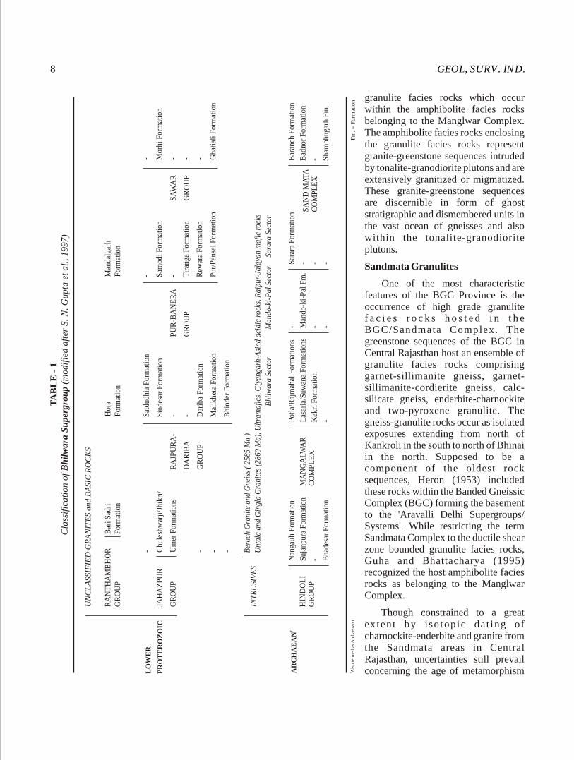
The stratigraphy of the Bhilwara Supergroup, as suggested by Gupta et al. (1997), is given in Table-1.
Metasediments included in the Bhilwara Supergroup consist of mica schist, quartzite, dolomite, marble, chert, fuchsite, quartzite and greywacke. Cross bedding, ripple marks and flute casts are occasionally present in the sediments. Composite gneiss/bimodal gneiss of igneous parentage, migmatite and hornblende and mica bearing schist represent a greater part of the Bhilwara Supergroup. Charnockite, granite, basic granulite and norite are also present.
Sandmata Complex
The Sandmata Complex is named by Gupta et al. (1980) after the Sandmata temple located south of Kekri. It forms a 200 km long and 50 km wide belt extending from Amet in the south to Kishangarh in the north. The western boundary is marked by the Delhi Supergroup which overlies the Sandmata Complex along tectonised unconformity. The eastern boundary with the Mangalwar Complex, lying to the east of Parbati and passing through Agucha and Jatan, described as a fault contact, has been rendered obscure by high-grade metamorphic effect and migmatization. The metamorphic-cum-migmatitic contact between the Sandmata Complex and the Mangalwar Complex practically coincides with the Delwara Lineament. On the southwest, the rocks of the Sandmata Complex are bounded by the rocks of the Aravalli Supergroup. The Sandmata Complex comprises migmatite, composite gneiss/bimodal gneiss, calc gneiss, garnet-sillimanite schist, biotite schist, garnet-staurolite-sillimanite schist, chlorite-biotite schist, mica schist, cordierite-garnet pelitic gneiss, enderbite-charnockite, pyroxene granulite, norite, hornblended schist, amphibolite, epidiorite, quartzite, fuschsite quartzite, conglomerate and dolomite marble. The complex is further characterized by preponderance of acid, mafic and ultramafic igneous suite. The Sandmata Complex is separated from the Mangalwar Complex on the basis that metamorphism in Sandmata Complex has reached upto the granulite facies as compared to the amphibolite facies metamorphism suffered by the Mangalwar Complex. The Sandmata Complex has been subdivided into three formations viz., the Baranch, Badnor and Shambhugarh Formations. The major intrusive phases include Giyangarh-Asind Charnockite-enderbite, Amet Granite, Anjana Granite etc.
According to a few researchers (Sinha Roy et al. 1992), the Sandmata Complex constitutes only the Ductile Shear Zone's (DSZ) bounded high pressure
GEOL, SURV. IND.8
granulite facies rocks which occur within the amphibolite facies rocks belonging to the Manglwar Complex. The amphibolite facies rocks enclosing the granulite facies rocks represent granite-greenstone sequences intruded by tonalite-granodiorite plutons and are extensively granitized or migmatized. These granite-greenstone sequences are discernible in form of ghost stratigraphic and dismembered units in the vast ocean of gneisses and also within the tonalite-granodiorite plutons.
Sandmata Granulites
One of the most characteristic features of the BGC Province is the occurrence of high grade granulite f a c i e s r o c k s h o s t e d i n t h e BGC/Sandmata Complex. The greenstone sequences of the BGC in Central Rajasthan host an ensemble of granulite facies rocks comprising garnet-sillimanite gneiss, garnet-sillimanite-cordierite gneiss, calc-silicate gneiss, enderbite-charnockite and two-pyroxene granulite. The gneiss-granulite rocks occur as isolated exposures extending from north of Kankroli in the south to north of Bhinai in the north. Supposed to be a component of the oldest rock sequences, Heron (1953) included these rocks within the Banded Gneissic Complex (BGC) forming the basement to the 'Aravalli Delhi Supergroups/ Systems'. While restricting the term Sandmata Complex to the ductile shear zone bounded granulite facies rocks, Guha and Bhattacharya (1995) recognized the host amphibolite facies rocks as belonging to the Manglwar Complex.
Though constrained to a great ex ten t by i so topic da t ing of charnockite-enderbite and granite from the Sandmata areas in Central Rajasthan, uncertainties still prevail concerning the age of metamorphism
TA
BL
E -
1C
lass
ific
atio
n of
Bh
ilw
ara
Su
perg
rou
p (m
odif
ied
afte
r S.
N. G
upta
et
al.,
1997
)
LO
WE
R
PR
OT
ER
OZ
OIC
UN
CL
ASS
IFIE
D G
RA
NIT
ES
and
BA
SIC
RO
CK
S
RA
NT
HA
MB
HO
RG
RO
UP
Bar
i Sad
riF
orm
atio
n H
ora
For
mat
ion
Man
dalg
arh
For
mat
ion
JAH
AZ
PU
R
GR
OU
P
Chu
lesh
war
ji/J
hikr
i/
Um
er F
orm
atio
ns
- - - -
RA
JPU
RA
-
DA
RIB
A
GR
OU
P
Sat
dudh
ia F
orm
atio
n
Sin
desa
r F
orm
atio
n
- - Dar
iba
For
mat
ion
Mal
ikhe
ra F
orm
atio
n
Bhi
nder
For
mat
ion
PU
R-B
AN
ER
A
GR
OU
P
- Sam
odi F
orm
atio
n
- Tir
anga
For
mat
ion
Rew
ara
For
mat
ion
Pur
/Pan
sal F
orm
atio
n
SA
WA
R
GR
OU
P
- Mor
hi F
orm
atio
n
- - - Gha
tial
i For
mat
ion
†A
RC
HA
EA
N
INT
RU
SIV
ES
HIN
DO
LI
GR
OU
P
Ber
ach
Gra
nite
and
Gne
iss
( 25
85 M
a )
Unt
ala
and
Gin
gla
Gra
nite
s (2
860
Ma)
, Ult
ram
afic
s, G
iyan
garh
-Asi
nd a
cidi
c ro
cks,
Rai
pur-
Jala
yan
maf
ic r
ocks
Bhi
lwar
a Se
ctor
M
ando
-ki-
Pal
Sec
tor
Sara
ra S
ecto
r
Nan
gaul
i For
mat
ion
Suj
anpu
ra F
orm
atio
n
- Bha
desa
r F
orm
atio
n
MA
NG
AL
WA
RC
OM
PL
EX
Pot
la/R
ajm
ahal
For
mat
ions
Las
aria
/Suw
ana
For
mat
ions
Kek
ri F
orm
atio
n
-
- Man
do-k
i-P
al F
m.
- -
Sar
ara
For
mat
ion
- - -
SA
ND
MA
TAC
OM
PL
EX
Bar
anch
For
mat
ion
Bad
nor
For
mat
ion
- Sha
mbh
ugar
h F
m.
† Als
o te
rmed
as
Arc
haeo
zoic
F
m. =
For
mat
ion
MISC. PUB. No. 30 (12) 9
and the process of exhumation of the granulite to the present level. Many of the workers believe that the granulite facies metamorphism is an Archaean event (Sinha Roy et al. 1992; Guha and Bhattacharya 1995), while others have assigned a late Palaeoproterozoic age to it. The only point of agreement, of course with a little departure, is the event of exhumation of the granulite to the present level as a Proterozoic one. Sinha Roy et al. 1992, Guha and Bhattacharya, 1995, considered the emplacement of the granulite facies rocks within the greenstone sequences by a process of thursting. While shear bounded (incidentally shearing is a very late phenomenon) granulites are noted within amphibolite facies rocks, but they are also found to overlie the amphibolite facies rocks along normal contacts (Gupta and Rai Chaudhri, 2002). The overfolding relationship is amply demonstrated by structural relationship between the cleavages related to the first two phases of deformation. It has been worked out that the event of exhumation of the granulite facies rocks is related to the second phase of deformation (producing overfolding; some workers invoking thrusting) which is a Palaeoproterozoic tectonic event.
Mangalwar Complex
The Mangalwar Complex is named after Mangalwar village which is located about 55 km southwest of Chittaurgarh. The complex occurs to the east of the Delwara Lineament in three main stretches, the first one extending from Pipalkhunt to Mangalwar for over 350 km and showing a width of 12 to 48 km, the second one from west of Amrite to Dadala for over a distance of 50 km (Sarara ki Pal inlier), and the third one from Kunda to Pratappur for over a distance of 30 km (Mando ki Pal inlier). In the Sarara ki Pal inlier area and also around Pipalkhunt and Gangapur, the Mangalwar Complex is overlain by the Aravalli Supergroup with an erosional unconformity. The eastern boundary of the complex is marked by the Hindoli Group of rocks with an uncertain stratigraphic relationship. In the southern part, the Deccan Traps overlie the Mangalwar rocks. The complex has been subdivided into the Lasaria, Kekri, Sarara, Mando Ki Pal, Suwana, Potla and Rajmahal Formations.
The Mangalwar Complex is considered presently as representing Archaean primary granite-greenstone belt. In the northern part, migmatitic gneiss-amphibolite association of the greenstone sequence is represented by banded gneiss, amphibolite, calc silicate rock and pelitic schist. In the sourthern part, mafic enclaves, represented
by amphibolite, migmatised gabbroic rock and chlorite schist, are by far the most prolific of the suite. High-magnesia mafic and ultramafic enclaves include tremolite-actinolite schist, magnetite and garnet bearing chlorite-actinolite schist, chlorite schist, talc-chlorite schist and talcose serpentinites with asbestos veins. Besides, long linear bodies of felsic volcanics in the form of quartzo-feldspathic rocks are also present. Sedimentary enclaves of varying dimensions comprise fuchsite quartizie, quartzite, garnetiferous mica schist, garnet-fibrolite bearing paragneiss, chert, carbonate and BIF. These rocks have been intruded by Untala-Gingla Granites, Berach Granite, Raipur-Jalayan mafic rocks and ultramafic rocks.
Hindoli Group
The Hindoli Group, named after Hindoli village, located 20 km northwest of Bundi, comprises a low-grade (greenschist) sequence predominated by turbidite and volcanics. The arcuate belt of the nearly continuous Hindoli Group, interrupted by Berach Granite, occurs along the eastern and southeastern flank of the BGC/Mangalwar Complex. The Hindoli Group is overlain unconformably by coarse clastics, carbonate, pelite and Fe formation of the Jahazpur Group. The 10 to 50 km wide arcuate belt of the Hindoli Group extends from Gyaspur in the south to Deyi in the north and further northeastward covering a strike length of about 400 km. The trend of the Hindoli belt is NNW-SSE in the southern part, which changes to ENE-WSW in the northern part. The southern part of the Hindoli Group is enclosed within the Berach Granite, while the ENE-WSW trending northern part is confined within two DSZ running sub-parallel to the regional axial trend of the Hindolis. While the northwestern shear separates the Hindoli metasediments from the Mangalwar Complex, the southeastern shear, familiarly known as the Great Boundary Fault (GBF), demarcates its boundary with the Vindhyan Supergroup. Towards south, the Hindoli Group is covered by the Deccan Traps. Gupta et al. (1980) interpreted the contact between the Hindoli Group and the Mangalwar Complex as a migmatitic front. Others (Sinha Roy and Malhotra, 1989; Sinha Roy et al. 1998; Malhotra and Pandit, 2000) on the other hand, believe that the contact is thrust along which the Mangalwar Complex has been uplifted and juxtaposed against the Hindoli Group. The major rock types of the Hindoli Group are metavolcanics with shale, slate, phyllite, mica schist quartzite, dolomite and limestone. Three lithofacies can be recognized in the Hindoli

GEOL, SURV. IND.10
Group, viz. turbidite facies comprising quartzwacke and slate with interstratified volcanoclastics, stable shelf facies of quartzarenite and carbonate, and mafic and felsic volcanics including acid tuffs (Bose and Sharma, 2000). Gupta et al. (1997), have subdivided the Hindoli Group into three lithostratigraphic units, viz., the Bhadesar Formation, the Sujanpura Formation and the Nangauli Formation. The rocks of the Hindoli Group are metamorphosed in the greenschist facies which grades to intermediate pressure amphibolite facies near the contact with the Mangalwar Complex.
The prevailing opinions regarding the contact relationship between the Berach Granite (2585 Ma; Crawford 1970) and the Hindoli Group are somewhat divided. Gupta (1934) and Sharma and Roy (1988) considered Berach Granite as forming the basement for the Hindoli volcano-sediments (Lower Proterozoic). On other hand, Raja Rao (1967, 1970), Gupta et al. (1980), Sinha Roy (1985) and Sinha Roy and Malhotra (1989) considered the Hindoli Group as of Late Archaean age being intruded by the Berach Granite.
Proterozoic rocks in the Bhilwara Province
Overlying the Hindoli Group of rocks and Manglwar Complex with an unconformity occur the next younger groups of rocks classified as the Rajpura-Dariba, Pur-Banera, Jahazpur and Sawar Groups which are exposed in a series of isolated linear belts. All these synformal metasedimentary basins/structures of Lower Proterozoic age occur in disjointed belts as outliers and they are mostly composed of dolomite, marble, calc-gneiss, calc-schist and calc-biotite schist; graphite-kyanite-staurolite schist, garnetiferous mica schist; banded chert, banded ferruginous chert and quartizite. These groups of rocks form important repositiories for deposits of copper, zinc, lead, silver, iron ore, marble, kyanite, steatite, quartz, corundum and garnet.
Rajpura-Dariba Group
A metavolcano-sedimentary sequence, named Rajpura-Dariba Group after the villages Rajpura and Dariba, in the Rajsamand district, overlies unconformably gneisses and schists belonging to the Mangalwar Complex in central Rajasthan and hosts exhaustive Pb-Zn deposits. The crescent-shaped NNE-SSW belt extends from Bharak in the north to Bhinder in the south. The group is made up of interbanded metachert, carbonaceous and argillaceous schist (tuffaceous containing ± graphite ± garnet ± staurolite ± kyanite), calcareous schist, calc silicate rock, dolomite,
marble with amphibolite bands, quartzite and conglomerate. The Rajpura-Dariba Group has been further subdivided into the Bhinder, Malikhera, Dariba, Sindesar and Satdudhia Formations. The sulphides of zinc, lead, copper and iron occur as thin bands and layers exhibiting characteristic syngenetic bedded geometry and show relict sedimentary structures. Silver mineralization has been reported from the dolomitic marble stratigraphically underlying the calc silicate rocks in the Bharak area (Goyal, 1991, 1992). However, the metasediments of Bharak, according to a few workers, belong to a separate belt, namely, Bharak-Satdudia belt, which contains metamorphosed basic and felsic volcanics.
Pur-Banera Group
The dominantly chemogenic sequence with bands of metaclastics occurs from south of Banera in the south to Samodi in the north, for over 80 km in a 3 km to 12 km wide belt. These rocks unconformably overlie the rocks of the Potla Formation of the Mangalwar Complex and have been included in the Pur-Banera Group. The unconformity is marked by a polymictic conglomerate coupled with structural break and secular change in the sedimentation pattern.
The sequence comprises conglomerate, garnetiferous mica schist, calc schist, calc silicate rock, calc silicate marble, amphibolite, dolomitic marble, magnetite quartzite (a persistent marker horizon) and banded magnetite chert. The rocks, exhibiting superposed deformation and regional metamorphism corresponding to amphibolite facies, have been classified into the Pur, Pansal, Rewara, Tiranga and Samodi Formations. The magnetite quartzite and the carbonates host strata bond zinc-lead-copper mineralization. The stratigraphic status of the metasediments of this belt is debatable. While some workers favour a Lower Proterozoic cover status, others have included it in the Archaean Bhilwara Supergroup.
Sawar Group
The chemogenic and clastic rocks exposed as isolated outcrops over 13 km long and 3 to 5 km wide area between Bajata in the north to Sawar in the south have been designated as the Sawar Group. It comprises mostly marble together with quartz-biotite schist, biotite-magnetite quartzite, amphibole quartzite and amphibolite surrounded by calc silicate rock, amphibolite, biotite gneiss and migmatites belong to the Kekri Formation of the Mangalwar Complex. The group
MISC. PUB. No. 30 (12) 11
has been divided into the Morhi and the Ghtiali Formations. Ray (1988) ascribed a gradational relationship between the Mangalwar Complex and the Sawar Group with the present contact marking an arrested granitic front. However, an unconformable relationship can be well worked out at places along the eastern margin of the Sawar belt where a gritty quartzite grading upward into a quartz-pebble conglomerate overlies the gneissic rocks (Das Gupta, 1995). Das Gupta (op. cit.) suggested that the grit-pebble conglomerate on the eastern fringe and the garnet-magnetite rock (intersected in the borehole) on the western fringe are contemporaneous and constitute the basal units of the Sawar Group. Chalcopyrite-pyrrhotite-galena mineralization is hosted in the dolomitic marble. The age of the mineralization has been determined at 2030 Ma with 1735 Ma as the age of remobilization (Deb and Thorpe, 2001)
Jahazpur Group
A low grade (greenschist facies) lithoassemblage comprising polymictic conglomerate, gritty quartzite, orthoquartzite, arkose mica schist, chert, breccia, dolomitic marble, carbonaceous phyllite and BIF, which unconformably overlies the Hindoli Group, occurs between southeast of Nandrai in Bhilwara district to Naenwa in Tonk district. The Jahazpur rocks are contained in two linear belts, each running for about 70 km and, at their widest part, measuring 3 km across. The eastern Jahazpur belt is encompassed within a sequence of turbidite-volcanic association of the Hindoli Group, while the western Jahazpur belt, extending from Jawal in the southwest to Dhanola in the northeast, unconformably overlies the Hindoli sequence. Along the thrust zone, delineating the western margin of the western Jahazpur belt, migmatites and gneiss of Mangalwar Complex have been juxtaposed on the Jahazpur belt. In the eastern Jahazpur belt, the base of the Jahazpur sequence overlying the Jahazpur Granite (correlated with the 2.5 Ga old Berach Granite) is marked by a pebbly quartzite and arkose bed and an overlapping Jahazpur dolomite. On the strength of the unconformable relationship with the Hindoli Group and the Berach Granite, Sinha Roy et al. (1998), considered the Jahazpur group as early Proterozoic, though Gupta et al. (1980, 1997) included it in the Bhilwara Supergroup.
Ranthambor Group
The molasses like sediments exhibiting very low grade metamorphism (some times in diagenetic state)
occurring as isolated outcrops over a distance of 200 km from southeast of Bari Sadri to north of Hora and Mandalgarh have been included in the Ranthambor Group. It comprises quartzite, slate and phyllite intruded by concordant dolerite sills and is considered to be the youngest member of the Bhilwara Supergroup (Gupta et al. 1980). The group has been classified into three coeval formations viz., the Bari Sadri, Hora and Mandalgarh Formations on the basis of their spatial disposition in isolated basins of deposition.
In a recent work from Sawai Madhopur area, Guha and Rai Chowdhury (1999) considered the Ranthambor Group as forming the basal part of the Vindhyan Supergroup. Here, the Ranthambor Group comprises dominantly an alternating sequence of sandstone, shale along with a minor carbonate and basal polymictic and lenticular conglomerate beds. Guha and Rai Chowdhury correlated the Ranthambor Group with the Satola Group (Balmiki Prasad, 1984) and also concluded that the sandstone member of the Ranthambor Group is akin to the Khardeola Sandstone of the Satola Group.
Metasediments of Agucha
At Agucha, in the eastern part of the central Aravalli range, an elliptical metasedimentary sequence comprising sillimanite-graphite-garnet bearing mica schist and gneiss (much in similarity with Khondalite of south India) with bands of calc silicate rock occurs within the Mangalwar Complex. The contact relationship of the metasedimentary rocks with the Mangalwar Complex is uncertain. The Agucha sequence is interpreted to represent vestiges of strongly tectonised early Proterozoic rift sequence raised to granulite facies (Ray, 1992). The rocks at Agucha form a southerly closing synform and a very high grade Pb-Zn deposit is hosted in sillimanite-kynaite-graphite-quartz-biotite schist
ARAVALLI - DELHI PROVINCE
The Aravalli-Delhi Province is occupied by rocks of the Proterozoic fold belts viz., the Aravalli Supergroup (Aravlli-Fold Belt) and the Delhi Supergroup (the Delhi-Fold Belt). The Aravalli Supergroup occupies mainly the southern and southeastern parts of Rajasthan, while an extensive tract in southwestern, central and northeastern Rajasthan is occupied by the Delhi Supergroup.

GEOL, SURV. IND.12
ARAVALLI SUPERGROUP
A thick pile, chiefly comprising metamorphosed and complexly folded Palaeoproterozoic clastogenic sediments with minor chemogenic and organogenic assemblages and interlayered basic volcanics, overlying the Manglwar Complex and the Sandmata Complex with an erosional unconformity, has been assigned to the Aravalli Supergroup. This assemblage of stratified metasediments and interlayered extrusives, together with synorogenic and late to post-orogenic acidic, basic and ultrabasic intrusives, covers a time span from 2500 Ma to 2000 Ma.
The rocks of the Supergroup show an inverted V-shaped map pattern with an arcuate disposition where the apex of the V is located near Nathdwara. The width of the belt in the north is about 40 km gradually fanning out to 150 km in the south. To the east, the Aravallis are bounded by the Bhilwara Supergroup and to the west these are overlain by the rocks of the Delhi Supergroup. Towards southeast, the Aravalli Supergroup is covered either by the Deccan Traps or alluvium. The average trend changes from NW-SE in the southern part to NE-SW in the northern part. Controversy exists about the nature of contact and the stratigraphic status of the rocks on the west of the Aravalli Supergroup. Gupta and Bose (2000) have indicated that the Aravalli and Delhi Supergroups are separated by the older basement rocks, which forms the southern extension of the greenstone sequence of the BGC/Bhilwara Supergroup. Dev and Sarkar (1990) considered the older basement rocks as an attenuated block of the separated BGC continent between the two supergroups. The western contact of the Aravalli Supergroup is envisaged as a tectonic contact. Similarly, though evidences of unconformity are present along the eastern contact of the Aravalli Supergroup, ductile shearing along the BGC/Bhilwara Supergroup-Aravalli contact has led to imbrication at places (Bhattacharya and Shekhawat, 1999). The rocks of the Aravalli Supergroup have undergone polyphase deformation and attained progressively higher grade of regional metamorphism reaching upto amphibolite facies. The rocks also show migmatization in the vicinity of the synorogenic plutonic activity.
The Aravalli Supergroup shows two distinct 'facies sequence' indicating deep-sea and near-shore shelf environments interpreted by many as eugeosynclinal-miogeosynclinal couple or as foreland-hinterland duplex. The eastern part of the supergroup is occupied by carbonate, conglomerate, quartzite, phyllite and proximal greywacke representing shelf facies, whereas
the western part of the supergroup has a totally carbonate free distal facies, with thin bands of arenite, representing deep water facies. Metabasic volcanics occur near the base of Aravalli Supergroup. The ultramafic rocks, represented mainly by serpentinite and its metasomatic alteration products, occur in the Aravalli Supergroup in the Rakhadev-Dungarpur area and in the area between Jharol and Gogunda. There is no unanimity on the tectonic significance and stratigraphic position of these ultramafic rocks. A number of granitic and gneissic bodies are enclosed by the Aravalli Supergroup. The unconformable relation between the gneisses of Sarara inlier and the Aravalli Supergroup is unequivocal. However, the relationships of the Aravalli rocks with other granitic bodies, namely, the Jaisamand Granite, Ahar River Granite, Udaisagar Granite, Lakapa Granite and Dudar Gneiss are debatable and are variously considered as 'basement inliers' (Roy et al. 1988), 'partly basement and partly remobilized part of the same' (Naha and Halyburton, 1977), 'partly basement and partly intrusive within the Aravalli Supergroup' (Sinha Roy et al. 1993), 'intrusive into the basal Delwara sequence, but forming the basement for the middle Debari sequence of the Aravalli Supergroup' (Shekhawat and Joshi, 1994) and 'intrusive within the Aravalli-Fold Belt' (Guha and Garkhal, 1993).
There is no unanimity in the stratigraphic classification of the Aravalli Supergroup. According to Gupta et al. (1997), the Debari Group forms the basement of the Aravalli Supergroup and comprises coarser clastics of the coast line environment, syn-sedimentary basic volcanics and associated pyroclastics and shallow marine carbonate and carbonaceous sediments with local development of phosphatic and non-phosphatic algal biostromes (Table-2). The Udaipur Group comprises coarse flysch-like sediments deposited in a proximal trough. The Bari Lake Group includes a volcano-sedimentary succession marking the second phase of volcanicity and upwarping, following the filling up of the proximal trough. The Jharol Group includes thick shaly flysch-like accumulation in a distal trough. The Kankroli and the Dovda Groups, extending across the Banas Lineament in the northern part, are composed of clastic and chemogenic sediments deposited under shallow marine conditions on topographic highs developed along the strike continuity of the Udaipur and Jharol troughs. The Nathdwara Group, exposed near Nathdwara, contains chemogenic rocks formed in a rectilinear shallow basin developed successor to the first phase of the Aravalli deformation.
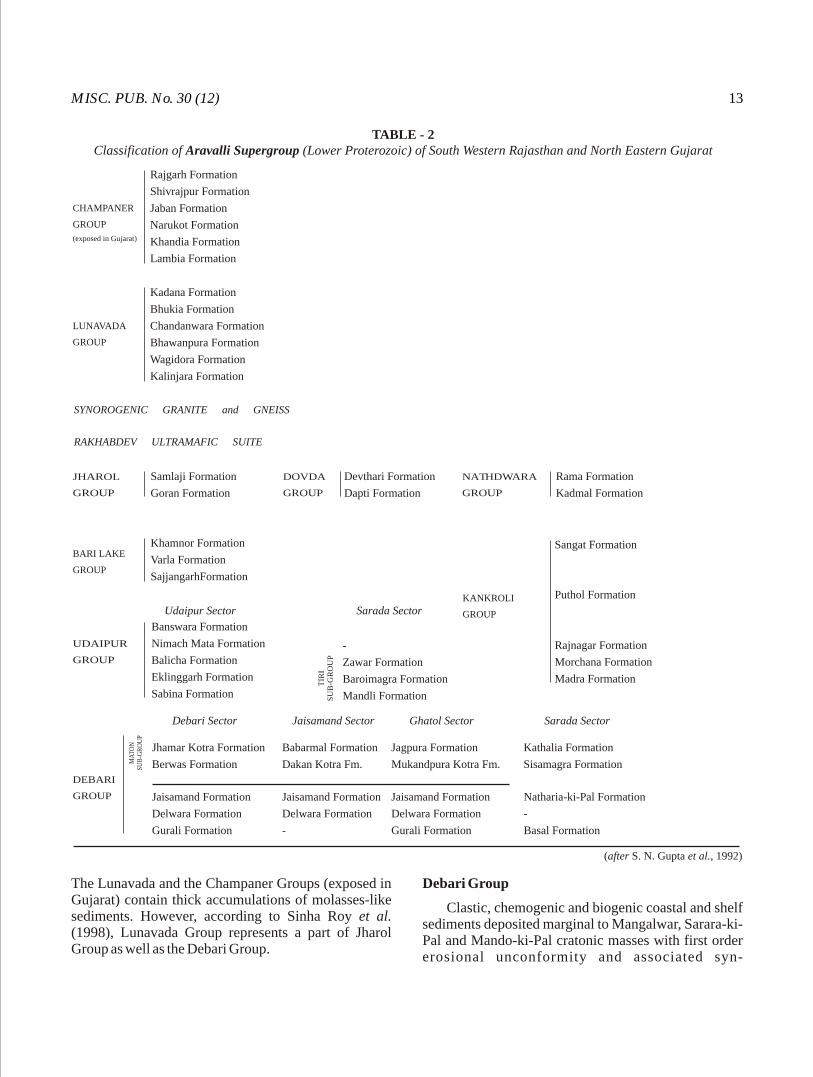
MISC. PUB. No. 30 (12) 13
The Lunavada and the Champaner Groups (exposed in Gujarat) contain thick accumulations of molasses-like sediments. However, according to Sinha Roy et al. (1998), Lunavada Group represents a part of Jharol Group as well as the Debari Group.
Debari Group
Clastic, chemogenic and biogenic coastal and shelf sediments deposited marginal to Mangalwar, Sarara-ki-Pal and Mando-ki-Pal cratonic masses with first order erosional unconformity and associated syn-
TABLE - 2Classification of Aravalli Supergroup (Lower Proterozoic) of South Western Rajasthan and North Eastern Gujarat
CHAMPANER
GROUP
(exposed in Gujarat)
Rajgarh Formation
Shivrajpur Formation
Jaban Formation
Narukot Formation
Khandia Formation
Lambia Formation
LUNAVADA
GROUP
Kadana Formation
Bhukia Formation
Chandanwara Formation
Bhawanpura Formation
Wagidora Formation
Kalinjara Formation
SYNOROGENIC GRANITE and GNEISS
RAKHABDEV ULTRAMAFIC SUITE
JHAROL
GROUP
Samlaji Formation
Goran Formation
DOVDA
GROUP
Devthari Formation
Dapti Formation
NATHDWARA
GROUP
Rama Formation
Kadmal Formation
BARI LAKE
GROUP
Khamnor Formation
Varla Formation
SajjangarhFormation
KANKROLI
GROUP
Sangat Formation
Puthol Formation
Rajnagar Formation
Morchana Formation
Madra Formation
UDAIPUR
GROUP
Banswara Formation
Nimach Mata Formation
Balicha Formation
Eklinggarh Formation
Sabina Formation
Udaipur Sector Sarada Sector
-
Zawar Formation
Baroimagra Formation
Mandli Formation
TIR
IS
UB
-GR
OU
P
Debari Sector Jaisamand Sector Ghatol Sector
DEBARI
GROUP
MA
TO
NSU
B-G
RO
UP
Jhamar Kotra Formation
Berwas Formation
Babarmal Formation
Dakan Kotra Fm.
Jagpura Formation
Mukandpura Kotra Fm.
Sarada Sector
Kathalia Formation
Sisamagra Formation
Jaisamand Formation
Delwara Formation
Gurali Formation
Jaisamand Formation
Delwara Formation
-
Jaisamand Formation
Delwara Formation
Gurali Formation
Natharia-ki-Pal Formation
-
Basal Formation
(after S. N. Gupta et al., 1992)
GEOL, SURV. IND.14
sedimentat ional shorel ine basic volcanics corresponding to an early depositional and volcanic episodes of the Aravalli geological cycle, have been included in the Debari Group (Gupta et al. 1980, 1997). It comprises a sequence of conglomerate, meta-arkose, quartzite, phyllite, mica-schist, basic metavolcanics with associated pyroclalstics, calcareous quartzite, dolomitic limestone, dolomite, calcitic marble, ferruginous chert, algal phosphatic dolomite and chert, and carbonaceous and manganiferous phyllite. The entire sequence has undergone polyphase deformation and regional metamorphism under greenschist facies.
The Debari Group forms high NW-SE trending hills west of the Mewar Plain and it can be traced between Pakhand in the north and Waori Khera in the south over a distance of 160 km. Beyond Waori Khera, the Debari Group is covered by the Deccan Traps. The Debari Group further occupies the fringes of the inliers of the BGC/Bhilwara Supergroup in Sarara-ki-Pal and Mando-ki-Pal areas. Lithostratigraphy of the Debari Group has been worked out separately in Debari, Jaisamand, Ghatol and Sarara sectors. Five formations, namely, the Gurali, the Delwara, the Jaisamand, the Berwas and the Jhamarkotra have been recognized in the Debari sector. Several other formations have been recognized in the Debari Group in the other sectors (Table-2). Sahu et al. (1991), have separated the Delwara Formation, comprising conglomerate, quartzite, carbonate, basic volcanics, chlorite phyllite and schist, from the rest of Debari Group and elevated status of the former to a Group. The polymictic conglomerate of the Debari Group unconformably overlies the Delwara metavolcanics. The presence of clasts of the Delwara metavolcanics within the polymictic conglomerate coupled with a structural hiatus between the Delwara Group and the Debari Group suggest the existence of a first order unconformity. The rocks of the Delwara Group occurs along the eastern margin of the Aravalli Supergroup discontinuously in an enechelon pattern between Nathdwara in the north to Phalet, Ora to Jaisamand, Salumbar to Ghatol and further beyond Talwara in the south.
Udaipur Group
A thick sequence of flysch-like, coarse to fine-grained rocks associated with minor bands of chemogenic/biogenic rocks representing the main depositional episode during the geosynclinal phase of the Aravalli geological cycle, has been included in the
Udaipur Group by Gupta et al. (1980, 1997).
Lithologically, the Udaipur Group comprises a thick pile of phyllite, metagreywacke, feldspathic mica schist and migmatite with intercalatory bands of greywacke, conglomeratic quartzite, dolomite, gritty dolomite, dolomitic marble, oligomictic conglomerate, phosphatic and stromatolitic dolomite, carbonaceous, manganiferous and ferruginous phyllite, chert and amphibole schists. The rocks show frequent interfingering and gradational relationships of different litho-units. The argillaceous metasediments constitute the bulk of the group. The rocks have undergone superimposed deformation and show a grade of metamorphism ranging from greenschist facies to amphibolite facies associated with syntectonic migmatisation. The Udaipur Group extends from northwest of Eklingjee in the north to Santrampur in the south for a distance of more than 180 km. The average trend of the group is NNW-SSE. Near Zawar, the belt of Udaipur Group bifurcates into two parts; the eastern one extends towards southeast through Padla, Salumbar, Ashpur, Sabla, Ganora and Banswara. The western one follows N-S trend and extends southwards through Paduna, Rakhabdev, Dungarpur and Satrampur. The eastern outcrop attains a maximum width of about 50 km near Sagwas. The western outcrop attains a maximum width of about 30 km, north of Dungarpur and thins out gradually to 5 km south of Dungarpur.
The rocks of the Udaipur Group have been divided into the Sabina Formation, Eklinggarh Formation, Balicha Formation, Neemach Mata Formation and Banswara Formation in the Debari sector while Mandli, Baroi Magra and Zawar Formations are recognized in the Sarada sector.
Bari Lake Group
The rocks of the Bari Lake Group occur between Kharpena in the south to Madar in the north through the Bari Lake covering a distance of 30 km. The width of the group varies from 3 km to 5 km. The rocks of the Bari Lake Group also occur between Kharpena and Iswal and occupy a roughly triangular area around Kadmas, Khamnor, Baita and Nathdwara.
The Bari Lake Group represents a volcano-sedimentary assemblage comprising coarse to fine-grained clastic sediments, syn-sedimentational basic volcanics, pyroclastic and volcaniclastic rocks overlying the Udaipur Group. This volcano-sedimentary association marks the local upwarping and
MISC. PUB. No. 30 (12) 15
shallowing of the trough and contemporaneous activation of a N-S trending deep seated fracture (Rakhadev Lineament) resulting in the outpouring of basic lavas. The Bari Lake group is principally composed of basic metavolcanics (actinolite-chlorite schist and chlorite schist), metamorphosed pyroclastics, quartz pebble-conglomerate, meta-arkose, quartzite, chlorite phyllite and metasiltstone with minor bands of dolomite, chert. The phyllite is, at places, carbonaceous.
The Bari Lake Group is further subdivided into several formations. The coarser clastic rocks have been included in the Sajjangarh Formation while the overlying volcano-sedimentary rocks are included in the Varla Formation. A thick sequence of phyllite and mica schist, around Khamnor, Batia, Kadmas and north of Iswal occuping area in continuity of the Bari Lake metavolcanics, and representing the metamorphosed products of fine grained pyroclastic and volcanic rocks, has been designated as the Khamnor Formation and is included in the Bari Lake Group. This formation is overlain by a persistent quartzite horizon considered to be the base of the overlying Jharol group. The rocks have undergone polyphase deformation and low grade regional metamorphism under greenschist facies condition.
Kankroli Group
The Kankroli Group occurs between Sangat in the west and Pipli in the east. It forms a hammer-head shaped arcuate outcrop. The main rock types of the Kankroli Group are garnetiferous muscovite-biotite schist, hornblende schist, hornblende biotite schist, hornblende gneiss and dolomitic marble with minor intercalations of quartzite. These rocks have undergone polyphase deformation and regional metamorphism under amphibolite facies condition.
Gupta et al. (1997) emphasized that the metamorphosed rocks at and around Kankroli belong to argillaceous facies and calcareous facies, which were deposited under shallow marine conditions. They classified the Kankroli Group into a number of formations, namely, Madra Formation, Morchana Formation, Rajnagar Formation, Puthol Formation and Sangat Formation. It is opined by Gupta et al. (op. cit.) that the Madra, Morchana and Rajnagar Formations are coeval with the Udaipur Group while the Puthol and the Sangat Formations are coeval with the Bari Lake Group. The rocks appear to have been deposited on a topographic high developed towards the northern extremity of the Udaipur-Zawar trench due to the reactivation of the Banas Lineament.
Jharol Group
The western part of the Aravalli Fold Belt comprises carbonate-free sequence of greywacke and phyllite with linear bands of quartz-arenite. This litho-sequence, which is exposed in a linear N-S trending belt, extending from Modasa in the south to Paroli in the north, over a distance of 190 kms, has been assigned as Jharol Group by Gupta et al. (1997). The lithosequence contains phyllite, chlorite schist, garnetiferous mica schist, quartzite, grit and conglomerate. According to Gupta et al. (op. cit.), the group unconformably overlies the Bari Lake Group towards east, while it is overlain by the Delhi Supergroup in the west with a plane of discontinuity in between. The Jharol Group has been subdivided into a lower Goran Formation, which is predominantly argillaceous in nature, and an upper Samlaji Formation comprising metapelites intercalated by quartzite and impure calcareous rocks. The rocks of the Jharol Group show a progressive increase in metamorphic grade from greenschist facies in the east to lower amphibolite facies in the west.
The stratigraphic position of the Jharol Group and its correlation with other groups of the Arvalli Supergroup is not convincingly established (Bose, 1989) and a part of the sequence in contact with the Delhi is construed to be southwest extension of BGC (Dev and Sarkar, 1990; Gupta et al. 1995; Gupta and Bose, 2000). According to Sinha Roy et al. (1993), the Jharol Group overlies the Debari Group in the northern part with an unconformity, the Iswal conglomerate representing the base of the Jharol Group. The Jharol Group, on this premise, represents the uppermost sequence of the Arvalli Supergroup. The western part of the Jharol Group contains conformable bands of mafic-ultramafic suite of rocks, sometimes intercalated with quartzite bands suggesting extrusive nature of the magmatic rocks. Bhattacharya and Shekhawat (1999) opined that the Jharol Group and the Debari Group were deposited in similar geological setting and hence are correlatable.
Dovda Group
The Dovda Group comprises chemogenic and clastic rocks belonging to a shelf-type sequence and is exposed from Masid in the southwest to the west of Kuanthal in the northeast and further towards east upto Khandel. It overlies the Kankroli Group in the central part and the Bari Lake Group in the southern part. At Paroti, the Dovda Group shows interfingering and
GEOL, SURV. IND.16
gradational relationship with the Jhalor Group. In the Richer and Kuanthal areas, the Dovda Group unconformably underlies the Delhi Supergroup. According to Gupta et al. (1997), the contact relationship of the Dovda Group with the BGC/Bhilwara Supergroup in Amet, Koshital, Kuraj-Salera area is not clear since the junction is blurred by migmatisation.
Gupta et al. (op. cit.) subdivided the Dovda Group into the Depti Formation and the Devthari Formation. The Depti Formation is made up of quartzite, hornblende schist, dolomitic-marble and calc-sillicate rocks. The assemblage of feldspathised hornblende schist, hornblendebiotite schist, biotite schist, ampbhibole gneiss and migmatite has been designated as the Devthari Formation
Heron (1953) included the migmatites, feldspathised schists and gneisses in the BGC, the dolomitic marbles and calc silicate rocks in the Raialo 'Series', the biotite schists and impure marbles in the Delhi 'System' and the quartzites, phyllites and schists in the Aravalli 'System'. Basu and Arora (1966) observed that near Sangat and Nathdwara, the quartzite and schists included in the Aravalli 'System' by Heron (op. cit.) show a gradational relationship with the gneisses and migmatites included under the BGC by Heron (op. cit.). A group of workers (Sharma 1983; Sinha Roy et al. 1993; Gupta et al. 1995) from their structural and metamorphic studies from the central Rajasthan, concluded that the pre-Delhi rocks underlying the Delhi metasediments in central and north-central Rajasthan, north of the Banas Dislocation zone, are not Aravallis or their granitized equivalents, and considered them as the BGC.
Nathdwara Group
Predominanatly chemogenic rocks associated with minor clastic sediments deposited in shallow-inland basins have been assigned to the Nathdwara Group. The group is temporally correlated with the Jharol and Dovda Groups and spatially succeeds the Bari Lake Group.
The rocks of the Nathdwara Group occur in two separate areas. The eastern tract lies between Rama in the south and Berach in the north while the western tract extends from Madar in the south to Kotharia in the northwest through Iswal and Nathdwara.
The bulk of Nathdwara Group in the eastern tract comprises phyllite and calcareous phyllite with
numerous intercalatory bands of dolomite and calcitic marble. Thick bands of quartzite occur towards the base. The western tract comprises dolomitic marble, chert, quartzite and mica schist. The Nathdwara sequence has undergone polyphase deformation and regional metamorphism under greenschist facies.
The Nathdwara Group has been subdivided by Gupta et al. (1997) into Kadmal Formation, Rama Formation and Haldighati Formation. The Kadmal Formation comprising calcareous and arkosic quartzite with intercalatory phyllite extends from east of Jindoli in the south to Berach in the north. The Rama Formation comprises phyllite and marble and is well exposed in the area northeast of Usar and southeast of Gurach. The Haldighati Formation is exposed between Madar in the south to Kotharia in the northeast and is made up of dolomitic marble, chert, quartzite, breccia and mica schist.
Lunavada Group
An assemblage of molasses-like sediments deposited in a widespread basin in the northern parts of Gujarat and southern Rajasthan has been designated as the Lunavada Group by Gupta et al. (1997). Structure of early deformation, present in the flysch-like and volcano-sedimentary assesmblages of the Udaipur, the Jharol and the Bari Lake Groups are absent in the Lunavada Group.
The Lunavada Group extends from Mahur in the north to Sejwada in the southeast and from Dharsua in the west to Kushagarh in the east. Towards southeast, the Lunavada Group is covered by the Deccan Traps. Towards northwest, it juxtaposes the Jharol Group. In the northeast, the rocks of the Lunavada Group are bounded by the Udaipur Group. Isolated outcrops of the Lunavada Group also occur in granitic terrain between Malu in the west and Tandwa in the east and also in the area north of Chota Udaipur.
Sinha Roy et al. (1998) have pointed out that the stratigraphic status of the Lunavada Group of Gupta et al. (1997) is not clear. As the Rakhavdeb ultramafic line in the type area separates the deep-sea Jharol facies in the west and the shelf facies Debari Group in the east, Sinha Roy et al. (op. cit.) opined that the Lunavada Group possibly represents a part of the Jharol as well as the Debari Group. Shekhawat and Joshi (1998), from their work in the Garhi-Partappur area, stated that the Lunavada Group of Gupta et al. (1997) has two distinct lithoassemblages separated by a prominent

MISC. PUB. No. 30 (12) 17
unconformity. Based on the observation made in the area, Shekhawat and Joshi (op. cit.) advocated for the untenability of a separate stratigraphic status of the Lunavada Group.
The predominant rock types of the Lunavada Group are phyllite, metasubgreywacke, quartz-chlorite schist and quartzite with subordinate dolomitic limestone, polymictic conglomerate, manganiferous phyllite and phosphatic algal dolomite. The rocks have been affected by at least two phases of deformation and were metamorphosed under greenschist facies condition.
The Lunavada Group has been subdivided by Gupta et al. (1997) into the Kalinjara, the Wagidora, the Bhawanpura, the Chandanwara, the Bhukia and the Kadana Formations.
DELHI SUPERGROUP
The Aravalli Mountain Range is mainly constituted by rocks of the Delhi Supergroup belonging to Proterozoic age. The rock sequences comprising the Delhi Fold Belt are sandwiched between the BGC/Bhilwara Group, the Aravalli Supergroup and the Palaeoproterozoic cover sequences in the east and the crystalline rocks of Archaean age (rocks equivalent to
TABLE - 3Classification of Delhi Supergroup (Lower to Middle Proterozoic)
INT
RU
SIV
ES
( P
ost
- D
elh
i )
South-western Rajasthan and North-eastern Gujarat Ajmer Sector North-eastern Rajasthan
MALANI IGNEOUS SUITE(Volcanic and plutonic)
ERINPURA GRANITE
GODHRA GRANITE(exposed in Gujarat)
DE
LH
I S
UP
ER
GR
OU
P
(modified after S. N. Gupta et al. 1992)
PUNAGARH
GROUP
Sojat, Bambolai,
Khambal and
Sowania
Formations
Jiyapura, Reodar, Ambeshwarand Khiwandi Fms.
SIROHI
GROUP
SENDRA-AMBAJI GRANITE and GNEISS
SINDRETH GROUP
(Angor and
Goyali
Formations)
DADIKAR, BAIRATH, AJITGARH
SIKAR and CHAPOLI GRANITES
KISHANGARH SYENITE
PHULAD OPHIOLITE SUITE
KUMBHALGARH
GROUP
GOGUNDA
GROUP
Todgarh, Beawar, Kotra,
Sendra, Ras, Barr, Basantgarh
and Kalakot Formations
Richer, Antalia and
Kelwara Formations
AJABGARH
GROUP
Ajmer
Formation
ALWAR
GROUP
Srinagar and
Naulakha
Formations
AJABGARH
GROUP
ALWAR
GROUP
RAIALO
GROUP
Kushalgarh, Sariska,
Thanagazi, Bhakrol and
Arauli Formation
Rajgarh, Kankwarhi,
Pratapgarh; Nithar,
Badalgarh and Bayana
Formations
Dogeta and Tehla
Formations
GEOL, SURV. IND.18
BGC of Heron, 1953), the Malani Iigneous Suite, the Marwar Supergroup (Neoproterozoic cover sequences) and Mesozoic-Cenozoic sediments in the west. The Delhi metasediments and related extrusive igneous rocks rest unconformably or with a structural discordance over the Bhilwara Supergroup in the northeastern and the central parts and the Aravalli metasediments (? BGC) in the southwestern part of Rajasthan and contiguous parts of Gujarat.
The Delhi Supergroup forming Aravalli (mountain) orographic axis extends over a strike distance of nearly 700 km from Idar in Gujarat in the southwest to Delhi in the northeast from where the Supergroup has derived its name. In central and southwestern Rajasthan, it is represented by a linear belt, which fans out from a narrow constricted part near Dewair towards northeast and southwest. According to Gupta et al. (1980, 1997), in the northeast, the rocks are deposited under fluvial conditions in a number of fault-bounded basins while in the central and southern parts; sedimentation is mostly under oceanic conditions.
Heron (1953) conceived the Delhi 'System' as occurring in two sectors, viz. in Alwar-Bayana-Khetri region and along a narrow linear belt (Main Delhi Synclinorium of Heron, 1953) forming the rib of the Aravalli Mountain range in Central and southwestern Rajasthan and northern Gujarat. Heron's (1917) initial concept of the Delhi stratigraphy was based on his works in the Alwar basin - a basal arenite-dominated Alwar 'Series', followed by the Kushalgarh Limestone and Hornstone Breccia, and mantled at the top by pelite-carbonate dominated Ajabgarh 'Series'. According to Heron (1917), the Alwar series rests unconformably over the limestone and quartzite of the Raialo 'Series', which was assigned a post-Aravalli and pre-Delhi status. Heron considered the Raialo 'Series' as spanning the Eparchaean unconformity between the Delhis and the Aravallis. Drawing an analogy with the stratigraphic order established in the Alwar basin, Heron, save for the Kushalgarh Limestone and Hornstone Breccia, extended the correlation and classification of the Delhi Supergroup (Delhi 'System' of Heron, op. cit.) to embrace the rocks of the Khetri and Bayana basins of northeastern Rajasthan and even to those of the Aravalli orographic axis in central and southern Rajasthan extending into Gujarat. Arora (1968) designated the Delhi System as the Delhi Group. Recognition of several groups has led subsequently to raise its stratigraphic rank to Delhi Supergroup Gupta et al. (1980) (Table-3).
Varied opinions exist regarding the physical subdivisions of the Delhi Fold Belt in different parts of Rajasthan. Heron (1917, 1953) believed a single evolution of the belt, which has subsequently been supported by Singh (1988). The Khetri sub-basin in the northern sector, according to Singh (op. cit.), continues southward to northern Gujarat and constitutes the Main Delhi Synclinorium of Heron, (1953). Gupta et al. (1980) and Sinha Roy et al. (1984), on the other hand, favour the idea of diachronous development of the Delhi sub-basins. Sinha Roy, (1988) recognized three sub-basins in the Delhi Belt in the northeastern sector, namely, the Bayana sub-basin, the Alwar sub-basin and the Khetri sub-basin. Gupta et al. (1998), Gupta and Bose (2000) have indicated the occurrence of rocks of migmatitic basement gneissic complex intervening between the two sectors and even in the interbasinal areas in the northern sector.
It has been suggested that the northeastern sector (Alwar-Bayana-Khetri region) of the Delhi Supergroup is older than Mesoproterozoic (Sastry et al. 1984). In this sector, several granite bodies (e.g. Dadikar, Bairat, Ajmer, Seoli and Harsora Granites) intrusive into the Delhi Supergroup have yielded Rb/Sr isochron ages older than 1600 Ma (Chaudhary et al. 1984). The age of the Bairat Granite as estimated by Crawford (1970) is 1600 Ma, while the isochron ages of the Udaipurwati and Saladipura Granites which intrude the Delhi Supergroup are estimated at 1480 Ma (Gopalan et al. 1979). Recently, zircons from the trondhjemite phase and the alkali granite phase of the Ajitgarh Granite have yielded 1.725 ± 0.013 Ga and 1.741 ± 0.015 Ga ages respectively (EPMA studies by Biju Sekhar et al. 2002). However, some workers consider the Seoli, the Udaipurwati, the Saladipura and the Ajmer Granite (Anasagar Granite) to be intrusive into the basement sequences (Gupta, 1989; Gupta et al. 1998; Gupta and Bose, 2000; Tobisch et al. 1994; Mukhopadhyay et al. 2000). On the other hand, granites intrusive into the Delhi Supergroup occurring along the linear belt (Main Delhi Synclinorium of Heron, 1953) have yielded a much younger age of 850 Ma (Sastry et al. 1984). The widely separated ages could be interpreted to represent two tectono-thermal episodes within apparently similar Delhi rocks, or that the development of the Delhi rock suite took place in two independent basins that were widely separated in space and time (Naqvi and Rogers, 1987). Thus, the geochronological data on granite plutons from the different parts of the Delhi Supergroup suggest a diachronous development of the Delhi Fold

MISC. PUB. No. 30 (12) 19
Belt, separated into the North Delhi Fold Belt (NDFB) in Alwar-Bayana-Khetri sector and the South Delhi Fold Belt (SDFB) in the areas near Ajmer and southward, the former predating the latter (Sinha Roy, 1984, 1988).
Although with many features remaining unresolved, the broad spatial division of the Delhis into two sectors, viz. the North Delhi Fold Belt (NDFB) of northeast Rajasthan and South Delhi Fold Belt (SDFB) of central and southern Rajasthan along the linear belt (Bose et al. 1990, Gupta et al. 1991a) conforms to differences between the two sectors in terms of lithofacies, structure, magmatism and metallogeny.
North Delhi Fold Belt
The North Delhi Fold Belt (NDFB) includes the Bayana-Lalsot, the Alwar-Jaipur and the Khetri basins. However, according to Gupta et al. (1998), Gupta and Bose, (2000), lithostratigraphy, magmatism and structural set-up of the Khetri Basin (Khetri Fold Belt - KFB) is proved to be an entity by itself.
The Bayana-Lalsot basin is located in the Bharatpur and Dausa districts of Rajasthan and falls 40 km southwest of Bharatpur. The basin constitutes the eastern-most part of the Delhi Supergroup. The Alwar-Jaipur basin extends from Jaipur in the south to beyond Rajasthan-Haryana border in the north. This basin occurs in between the Bayana-Lalsot basin in the east and the Khetri basin in the west. The Alwar-Jaipur basin is the widest amongst the three basins. In the Bayana-Lalsot and Alwar-Jaipur basins, the sedimentary sequences were deposited in fluvial and marginal marine environments and the volcanics show continental affinity (Singh, 1984). The major stratigraphic units of the Delhi Supergroup in the Bayana-Lalsot and the Alwar-Jaipur belts are the lower Raialos (mainly calcareous), the middle Alwar (mainly areanaceous) and the upper Ajabgarh (mainly argillaceous) Groups. The different groups of the Delhi Supergroup in these two belts do not show a complete development of their lithoformations throughout the fold belts. Often there is absence of formations as well as facies variations within the different groups.
The Khetri basin extends from Pacheri in the north to Sangrua in the south for a distance of about 100 km. The basin is also known as Khetri Copper Belt because of it hosting copper deposits in and around the Khetri town, situated 160 km SSW of Delhi. To the east, the basin is bounded by the BGC/rocks of the Delhi Supergroup in the Alwar-Jaipur Fold Belt, while sand
dunes occupy its western part.
Heron (1923) correlated the rocks of Khetri basin with the psammitic Alwar and pelitic Ajabgarh 'Series' of Alwar-Jaipur basin on the basis of lithological similarities. Heron (op. cit.) observed gradational contact relation between the two series. While retaining Heron's classification, Dasgupta (1968) noted the gradational nature between the Alwar and the Ajabgarh 'Series' and observed that at places the Ajabgarh 'Series' alternates with the Alwar 'Series'. Later workers followed Heron's classification while carrying out works on different aspects (Ray, 1974; Gangopadhay, 1987). Chakrabarti & Gupta (1990) considered the low to high grade migmatised rocks in the southern part of the KFB as the unclassified pre-Delhis. They also correlated the high grade migmatised rocks intervening between the Alwar-Jaipur belt and Khetri Fold Belt with the Manglwar Complex (Gupta et al. 1980) or BGC (Heron, 1953) occurring to the south of the Sambhar lake.
The correlation of the lithologies of Khetri basin with those of the Alwar and Ajabgarh sequences of the respective type areas is controversial. According to Sinha Roy et al. (1980), the so-called Ajabgarh and a part of the so-called Alwar of the Khetri area are in fact equivalent to the Raialo Group which in turn is a pre-Delhi sequence. Gupta et al. (1998) divided the Khetri Fold Belt into North Khetri Belt and South Khetri Belt, separated by the Kantli tranverse fault. According to them, the North Khetri Belt and South Khetri Belt evolved independently. In the North Khetri Belt, the basement-cover interface is represented by an unconformity, while that in the South Khetri Belt is marked by a detachment fault (Chapoli Fault). It has been further demonstrated that the cover sequences on either side of the Kantli Fault differ significantly from each other in lithocharacteristics, especially in the content of felsic volcanics (1832 ± 3 Ma) present in the South Khetri Belt.
South Delhi Fold Belt
The South Delhi Fold Belt (SDFB) of the Delhi Supergroup exposed in central and southern Rajasthan and in northeastern Gujarat forms the spine of the Aravalli mountain range. This fold belt extends from near Ajmer in the northeast to Himmatnagar in Gujarat with a NNE-SSW to NE-SW trend. Further southwest of Himmatnagar, the Delhi rocks are covered by large alluvium tract. The Delhi rocks in the South Delhi Fold Belt, according to Heron (1953) are disposed in a major
GEOL, SURV. IND.20
synclinorium (named as the Main Delhi Synclinorium). The Synclinorium in central Rajasthan consists of two synclines separated by a tongue of pre-Delhi rocks (Pre-Delhi inlier) which tapers at either end. Heron (op. cit.) classified the Delhi 'System' of the Main Delhi Synclinorium of central and southern Rajasthan into Alwar and Ajabgarh 'Series' without establishing the younging polarity. According to Heron, the basal conglomerates (the Barr conglomerate on the western flank and the Srinagar conglomerate on the eastern flank) on either flank of the Aravalli mountain range rests on porphyritic and foliated granite (pre-Delhi) with an erosional unconformity. Sen et al. (1964) remarked that the unconformity below the Delhi 'System' is not apparent, as the contact is sheared or conformable.
The stratigraphy of the SDFB cannot be correlated clearly with that of the NDFB. Gupta et al. (1980) partially retained the classification of Heron, but coined the terms Gogunda Group and Kumbhalgarh Group for central and southern Rajasthan and correlated them with the Alwar and Ajabgarh Groups NDFB respectively. Gupta et al. (1997) opined that in the southern Rajasthan and in the contiguous areas in the northern Gujarat, the Delhi sedimentation took place in geosynclinal regime in contrast to beach-type and shelf-type sedimentation in North Delhi Fold Belt. In SDFB, the deposition took place on shelf-margin to shelf-interior, main trough and in post-orogenic succession basins. The dominantly arenaceous and argillaceous facies, deposited on shelf-margin, have been referred to as the Gogunda Group. The mixed calcareous and argillaceous facies of the shelf-interior has been included Kumbhalgarh Group. In the west of the Aravalli mountain range, the clastic marine sediments deposited in a deeper trough have been included in the Sirohi group and the molasses-like sediments of shallow basins have been accommodated in the Punagarh and the Sindreth Groups.
Sen (1981 and 1983) identified five tectonic zones (zone 1 to zone 5 from west to east) in the SDFB, each with an independent structural grain and with mutual tectonic contacts which often exhibit discordance to litho-boundaries. Each of these exhibits east-west trending early major fold. Sen (1981, 1983) suggested that the Barr conglomerate occurring on the western flank lies over the Barotiya sequence and not at its base. He conceived the eastern boundary of zone 2 in the south/or the continuing eastern boundary of zone 3 in the north as the palaeosuture zone. With this conception, he considered the zones 1, 2 and 3 (Pindwara-Ajmer Fold Belt) west of the palaeosuture zone as the younger
units and these together constitute the Delhi Supergroup. The zones 4 (Sayara Linear Belt) and 5 (Antalia Linear Belt) in the Gogunda-Antalia area constituting the rock sequence named as the Gogunda Group by Gupta et al. (1997), according to him, are older sequences spanning the gap between the Aravallis and the Delhis. A pre-Delhi status has been assigned for the Gogunda Group in the Antalia-Richer area by Gupta et al. (1995).
Gupta et al. (1988, 1991a, 1995), Gupta and Bose (2000) proposed a new stratigraphic scheme for the SDFB. According to them, the axial region in central Rajasthan comprises multiple tectonic units (cf. Sen, 1980), which retain their individuality of lithocharacters, structure, magmatism and metamorphism. They delineated five lithotectionic units, namely, Basantgarh, Barotiya, Sendra, Rajgarh and Bhim, from west to east, all of them together forming the Delhi Supergroup. Tectonic discordance in the form of early ductile shear zones and superposed brittle ductile shear zones demarcate the boundary surfaces of each unit. This is in contrast to the synclinorial disposition of the lithounits as suggested by Heron (1953). A linear belt of the pre-Delhi rocks tapering at the southern end, west of Todgarh, subdivides the SDFB into two basins: western part Basantgarh-Barotiya-Sendra basin and the eastern part Bhim-Rajgarh basin, the two having no similarity in basinal deposits. Another group of rocks, namely, the Devgarh Group, occurring east of the Bhim Group, is tentatively included in the eastern basin. True stratigraphic status of the Devgarh group is uncertain. Gupta et al. (1995), Gupta and Bose (2000) have indicated a diachronous evolutionary history for the Delhi Supergroup of the South Delhi Fold Belt. They have indicated a time-equivalency for the Basantgarh, Barotiya, Sendra, Rajgarh and Devgarh groups and a younger status for the Bhim Group. It appears that zones 1, 2 and 3 of Sen (1980) correspond respectively to the Barotiya, Sendra and Rajgarh Groups. Zone 4 corresponds to the Bhim Group while zone 5 corresponds to part of the Aravalli Supergroup of Gupta et al. (1980). Also, according to Gupta et al. (1995), Gupta and Bose (2000), unconformity-cum-structural hiatus between the crystalline rocks of Archaean age (similar to BGC rocks) on the west of the Aravalli mountain range and the Ras Marble (Chowdhury et al. 1993) along with the involvement of the former in the folding of the Ras Marble gives a status of cover sequence for the latter.

MISC. PUB. No. 30 (12) 21
The pre-Delhi inlier separating the two basins of the Delhi Supergroup near Ajmer is represented by mica schist, granite gneiss, quartzite, migmatites, calc silicate rocks and marble (Gupta et al. 1995; Gupta and Bose 2000).
Raialo Group
According to Heron (1917, 1953), the Raialos occur as a basal constituent of the Delhi Supergroup or as an independent unit spanning the Eparchaean unconformity. Heron described the Raialos as predominantly composed of limestone with a thin impersistent band of quartzite, occasionally conglomerate, at its base. He recognized the basement rocks over which the Raialos rest at different places as the Aravallis, the Bundelkhand Gneiss or the Banded Gneissic Compless (BGC).
The small isolated outcrops of Raialos of Heron (1953) in the BGC terrain of Bhilwara Province outside NDFB were regarded by later workers (Naha et al. 1966a, 1966b, 1969, 1973; Naha & Mazumdar, 1971a, 1971b; Roy et al. 1984; Sen 1983) as parts of the gneissic rocks. According to these later workers, the marbles and the quartzites which were included in the ambit of the Railao Series outside the NDFB and presumably deposited during the Eparchaean interval, actually formed in different environments and belong to different stratigraphic horizons ranging from middle Archaean to Neoproterozoic.
It is now agreed to retain the term Raialos within the NDFB in the Alwar-Jaipur and Bayana-Lalsot belt only. Roy (1988) advocated renaming of Raialos in the NDFB as the Rayanhala Group (after the village name) to avoid confusion. The Raialo Group is best exposed around Dogeta, Gola-Ka-Bas, Raialo-Sankotra, Jhiri, Tilwarhi, Todi and kho-Dariba.
Mapping from Geological Survey of India over a period of two decades (Banerjee, 1980; Sant and Sharma, 1973; Singh, 1982; Singh and Sinha, 1983; Singh et al. 1985, 1986) suggested the following modifications of the stratigraphic succession as proposed by Heron (1917): (a) the entire Aravalli 'System' of Heron is missing from the Alwar area and re-designated the basement rocks as pre-Delhi (? Pre-Aravallis). (b) the Raialo 'Series' of Heron constitutes a part of the basal unit of the Delhis and is not a separate entity as suggested by Heron (1953), (c) the stratigraphic break between the Raialos and the overlying Alwar exist at a higher level than that
proposed by Heron including the volcanic sedimentary assemblage within the Raialos. The status of the Raialos has been raised to a group and is classified into lower Dogeta Formation (siliceous and dolomitic marble with subordinate conglomerate, quartzite and metasiltstone) and upper Tehla Formation (conglomerate, quartzite, metasiltstone and marble with mafic and felsic volcanics) in the Alwar-Jaipur basin, and into lower Nithar Formation (basal conglomerate and quartzite with interfingering lenses of conglomerate and pebbly quartzite) and an upper Jahaz-Govindpura Formation (basic and associated metasedimentary interbands) in the Lalsot-Bayana basin. Stromatolitic structures are present in the Tehla formation. The 'Serrate Quartzite' in the Alwar-Jaipur basin considered by Heron as the lowermost member of the Alwar sequence actually constitutes the basal member of the upper Raialos. However, Singh (1988) considered the Serrate Quartzite (conglomerate-sandstone, subordinate argillite) as a separate formation. According to Singh (op. cit.), the initiation of Delhi sedimentation was related to crustal downwarping producing isolated depo-centres. After the Dogeta sedimentation, downwarping of the existing basins and block faulting took place. This resulted in the formation of the Surer Graben in the Alwar-Jaipur basin in which the Serrate Quartzite was deposited. The end phase of the Raialo sedimentation was characterized by rejuvenation of the old faults and development of some intra basinal faults, which tapped basic to felsic volcanics of the Tehla Formation.
Alwar Group
The Alwar Group rests unconformably over the Raialos, in places, directly (overlapping) the Pre-Delhi rocks, and is predominantly composed of conglomerate and quartzite (subordinate siltstone and quartzose wacke). It is interesting to note that the unconformity between the Raialo Group and the Alwar Group represents a basin-wide break and is recognized in Alwar-Jaipur and Bayana-Lalsot basins (Gupta and Bose, 2000).
The Alwar Group is divided into Rajgarh, Kankwarhi and Pratapgarh Formations in the Alwar-Jaipur basin and Jogipura, Badalgarh, Bayana and Damdama Formations in the Bayana-Lalsot basin. At places, basic flows, meta-tuff and intercalated magnetitic quartzite are reported from the Alwar Group (Gupta, 1989).
The Rajgarh Formation is developed in the southern

GEOL, SURV. IND.22
part of the NDFB and contains a basal conglomerate followed upwards by feldspathic quartzite and grit. The Kankwarhi Formation is well developed in Raialo-Ajabgargh, Alwar, Lekri, Hamirpur and Bhindosi areas. The rock types in this formation are quartzite, schists, calcareous biotite quartzite and marble. The Pratapgarh Formation occurs in the southern part of the NDFB and comprises sericite quartzite and orthoquartzite. The quartzite is more mature than that in the Rajgarh Formation.
In the Lalsot-Bayana basin, the Jogipura Formation is best developed near Jogipura and Sita Kund. It comprises two members, namely, Sita conglomerate and quartzite. The Badalgarh Formation occupies the slope of hills from north of Sikandra in the east to west of Sita Kund in the west and from Bareja to south of Nagla Gothia. The formation is composed of an interlayered sequence of thinly bedded feldspathic quartizite, micaceous quartzite, shale and tuffaceous sandstone. The Bayana Formation is well exposed around the villagel Bayana, south of Damdama, north of Khereri, around Mahloni etc. Two members, namely, a lower Mor Talav quartzite and an upper Mahloni conglomerate have been recognized in this formation. The Damdama Formation has been classified into three members, namely, Umraind conglomerate, Kanawar quartzite and Lakhanpura sandstone in order of decreasing age (Singh, 1982). The main rock types of the Damdama Formation are conglomerate, quartzite, sandstone and shale.
The correlation of the lithologies of Khetri basin with those of the Alwar and Ajabgah sequences of the respective type areas is controversial. However, the lithologies included within the Alwar Group in the Khetri basin are pelites, quartzite-arkose and amphibole quartzite and marble, while those in the Ajabgah Group are pelites, marble calc gneiss and quartzite.
Ajabgah Group
In the Lalsot-Bayana basin, the Ajabgarh Group overlies the Alwar Group with a disconformity in between. It comprises a lower Kushalgarh Formation and an upper Weir Formation. The main litho-types of the Ajabgarh Group are carbonaceous shale, phyllite and quartzite.
The Kushalgarh Formation occupies the area around Sita, Khairora, north of Hathori and east of Karwan. The rock types of Kushalgarh Formation are carbonaceous shale, phyllite and minor quartzite. The Weir Formation is
made up of quartzire, which is cherty at places.
The baryte deposit of Hathori area, Bharatpur district have earlier been reported to occur as fracture fillings in quartzite, which are closely associated with post-Delhi intrusive dolerites (Heron, 1917; Mathur, 1945; Roy 1958; Jain, 1965; Bhattacharya, 1969). Later investigation in the area has revealed that the baryte mineralization is confirmed within the basic volcanics and associated shale and quartzites of the Delhi Supergroup. Baryte veins occur as fracture fillings along well defined shear zones trending NE-SW to NNE-SSW and along bedding joints.
In the Alwar-Jaipur basin, the Ajabgarh Group, overlying the Alwar Group conformably in the central part of the basin and disconformably along the flanks, consists of five formations- Kushalgarh, Seriska, Thana Gazi, Bharkol and Arauli-Mandan Formations. The lower one is stromatolitic with phosphatic carbonate in the west grading to quartzite-silitstone in the east with ubiquitous presence of basic flows and tuffs. The upper four formations are psammopelitic with subordinate chert-breccia, tuff, argillite and carbonate. Chakrabarti and Gupta (1990) included the Seriska Formation within the Thana Gazi Formation.
The Kushalgarh Formation or the Kushalgarh Limestone comprises alternating siliceous schistose marble band and dolomite-rich band with the black calc schist marking the base of the formation in the southern part of the North Delhi Fold Belt. The Seriska Formation exclusively comprises quartzite, ferruginous quartzite, phyllite (Hornstone Breccia of Heron, 1953), carbonaceous phyllite and marble. The Thana Gazi Formation comprises carbonaceous phyllite (meta-tuff), quartzite, feldspathic calc-arenite, marble and breccia. Felsic volcanic rocks are also identified within this unit (Gupta & Sharma 1998). Overlying the Thana Gazi Formation is the Bharkol Formation represented by an interlayered sequence of phyllite (dominantly carbonaceous) and quartzite (usually gritty). A sequence of garnet±andalusite-bearing chlorite schist and quartzose phyllite exposed at places has been tentatively bracketed within the Bharkol Formation because of its stratigraphic position below the overlying Arauli Formation. The youngest litho-unit, the Arauli Formation, in the Ajabgarh Group is represented by carbonaceous phyllite (meta-tuff), garnetiferous chlorite schist and garnet-staurolite schist.

MISC. PUB. No. 30 (12) 23
Heron (1953) considered the Kushalgarh Limestone as separate unit sandwiched between the Alwar and the Ajabgarh Groups in the Alwar-Jaipur basin. Later workers included Kushalgarh Limestone as the basal member of the Ajabgarh Group. It was also noted that Hornstone Breccia of Heron (op. cit.) does not form a definite time rock unit and occurs at different stratigraphic levels within the Ajabgarh Group in NDFB (Chakrabarti & Gupta, 1990). It occurs both as a clastic sedimentary breccia above the basal Ajabgarh and as brecciated quartzites in different rock units within Ajabgarh (Heron, 1953; Banerjee, 1980; Gupta and Sharma, 1998). Gupta and Sharma (op. cit.) favoured a volcanogenic origin of the breccia.
Gounda Group
In the South Delhi Fold Belt, the rocks, which were earlier mapped as Lower Delhi Group by Arora and Ramchandran (1971) together with the outliers of calc-schist of Ajabgarh (cf. Heron, 1953) have been grouped together under the Gounda Group by Gupta et al. (1980, 1997). The group comprises quartzite and interbedded schist with subordinate impure calcareous metasediments. The rocks of the Gounda Group are traceable from Kishangarh to Richer. These rocks take a sinistral shift near Antalia and then continue southwards (up to Himmatnagar) in Gujarat. The unit attains its maximum width around Gounda. The rocks of the Gounda Group have been separated into three depositionally related litho-associations which have been designated as the Richer, Antalia and Kelwara Formations in descending order.
According to Sen (1981, 1983), the rock sequences of the Gounda Group in the Antalia-Richer area spans the gap between the Aravallis and the Delhis. A pre-Delhi status has been assigned for the Gounda Group in the Antalia-Richer area by Gupta et al. (1995). Gupta et al. (1995), has renamed part of the Gounda Group extending from near Badnor in the north to Kitela in the south as the Devgarh Group and tentatively included it within the Delhi Supergroup.
Kumbhalgarh Group
The rock sequence occurring in the west of the Gounda Group in the South Delhi Fold Belt has been termed the Kumbhalgarh Group by Gupta et al. (1980, 1997) and is traceable as a broad, linear belt occupying the western part of almost the entire length of the main Aravalli Range. It runs NE-SW or NNE-SSW from
south of Rajgarh-Pisangan area in the north up to Khed Brahma in the south, over a distance of about 290 km. Lithologically, this group is represented by a sequence of calc-gneiss and calc-schist, pure and impure calcitic marble, muscovite-biotite schist, calc-biotite schist, migmatites and gneiss, quartzite, conglomerate and amphibolite. The sequence has a general sharp contact with the rocks of the underlying Gounda Group and at places with the overlying Sirohi Group. The rocks of the Kumbhalgarh Group have been regionally metamorphosed under amphibolite facies and the effects of contact metamorphism are well-marked towards the western side where they are intruded by acidic and basic rocks. The rocks of Kumbhalgarh Group have been dividied into the Todgarh, Sendra, Basantgarh, Beawar, Kotra, Barr, Ras and Kalakot Formations which do not always indicate the order of superposition. The rocks show a general younging towards west.
In a new stratigraphic scheme proposed by Gupta et al. (1988, 1991 and 1995), Gupta and Bose (2000) for the SDFB, the axial region in central Rajasthan comprises multiple tectonic units (cf. Sen, 1980) which retain their individuality of lithocharacters, structure, magmatism and metamorphism. The delineated five lithotectonic units, namely, Basantgarh, Barotiya, Sendra Rajgarh and Bhim Groups, from west to east, deposited in two basins, namely, the western Basantgarh-Barotiya-Sendra basin and the eastern Bhim-Rajgarh basin. Tectonic discordance in the form of early ductile shear zones and superposed brittle ductile shear zones demarcate the boundary surfaces of each unit.
TRANS-ARAVALLI-PROVINCE
Trans Aravalli Province in the western part of the Aravalli Range is constituted by rocks of Malani Igenous Suite along with crystalline rocks of the Archaean age (equivalent to BGC), the Marwar Supergroup and the Mesozoic-Cenozoic sedimentary sequences. Heron (1953) opined that the rocks to the west of the Aravalli Mountain Range are older than the Delhis and are possibly correlatable with the Banded Gneissic Complex (BGC). Heron described it as 'ancient' gneiss of grey, fine-grained rock of rather granitic composition and texture, generally ferruginous but sometimes porphyritic and foliated. To the southwest, it is profusely intruded by post-Delhi Erinpura Granite. Gupta et al. (1991, 1995) also
GEOL, SURV. IND.24
suggested the pre-Delhi status of the rocks. According to Gupta et al. (op. cit.), the early deformation in these gneisses and schists and polymetamorphism in them, are absent in the overlying Delhi rocks, the latter younging easterly. The rock components include pelitic schist, garnetiferous quartzo-feldspathic gneiss, quartzite, thin marble bands and suspected metabasic flows now occurring as amphibolites. The rocks have suffered metamorphism upto sillimanite I grade and a phase of migmatization prior to the earliest deformation of the Delhis. According to Gupta (2004), the pre-Delhi migmatites and gneisses in the Trans-Aravalli region are product of granitization of the volcano-sedimentary rocks of the Sirohi Group only.
Farther west in the Trans-Aravalli region, the gneissic rocks of the migmatized pre-Delhis (Sirohi Group) are succeeded by a slate, phyllite and metatuff succession of Sojat Formation metamorphosed in the granulite facies. The Sojat Formation occurs in scattered isolated outcrops and as enclaves within the Erinpura Granite and Jalor Granite; the latters are intrusive into the former. The stratigraphic status of the Sojat Formation remains uncertain because of lack of isotopic age data.
Sirohi Group
According to Gupta et al. (1980, 1997), the Sirohi Group in the west of the South Delhi Fold Belt, comprised flysch-like thick deposits of fine argillaceous sediments viz. phyllite, mica schist and biotite schist alongwith intercalactions of arenaceous and calcareous sediments (quartzite and marble) deposited during the peak or terminal orogenic phase of the Delhi geological cycle. The rocks occur in the form of a broad belt occupying the plains of Marwar lying to the southwest of Aravalli range. They have been traced as outcrops from Reodar-Chandrawati area in southwest to Gandoch and Kot in the northeast for a strike length of about 160 km over a width of about 30 km. The continuity of the belt is either lost under a thick soil/sand cover in the area or interrupted by the intrusive Erinpura Granite. The rocks have been deformed and have been regionally metamorphosed to greenschist facies. The metasediments of the Sirohi Group have been subdivided by Gupta et al. (1980, 1997), in order of antiquity, into the Jiyapura, Reodar, Ambeshwar and Khiwandi Formations. Gupta et al. (1997), considered the Sirohi Group and the Sindreth Group as belonging to the upper part of the Delhi
Supergroup in southern Rajasthan.
Although Gupta et al. (1997), considered the Sirohi Group and the Sindreth Group as belonging to upper parts of the Delhi Supergroup, mention may be made about the varied opinions existing regarding the sttratigaphic status of the Sirohi/Sindreth Group. While describing the geology of the Sirohi region, Hacket (1881) included the rocks of the area into the 'Aravalli Series'. Coulson (1933) considered the deformed metasedimentary rocks (Sirohi Group of Gupta et al. 1997), as well as the undeformed sedimentary-volcanic ensembles (Sindreth Group of Gupta et al. 1997) as belonging to the 'Aravalli System' of supposedly Archaean age.
According to Mukhopadhyay (1990), Gupta and Bose (2004), Gupta (2004), the Sirohi Group is represented by deep sea facies assemblage manifested by argillaceous metasediments and migmatities (generally augen gneiss and granite gneiss) associated with carbon phyllite-bedded chert-carbonate- ultramafic-acid tuff (Gupta et al. 1989; Mukhopadhay, 1989). The ultramafics are present as small lenses within bedded chert-carbonate rocks. These are intruded by a number of granitic bodies and quartz-felspar porphyry dykes. Of the granitic rocks occupying the western and eastern flanks of the Sirohi Group in the southwestern Rajasthan, considered earlier as post Delhi Erinpura Granites, a major part actually represents migmatized Sirohi sediments and volcanics while others belong to the intrusive phase (Mukhopadhay, 1990). According to Mukhopadhyay (1990), Gupta and Bose (2004), Gupta (2004), the migmatized sequence extends northeastward occupying the entire area earlier marked as BGC by Heron. The rocks have suffered metamorphism upto sillimanite-I grade and a phase of migmatization prior to the earliest deformation of the Delhis. Gupta et al. 1989; Mukhopadhyay, 1990; Fareeduddin et al. 1991 has drawn an analogy between the Sirohi Group and the mica schist-phyllite-ultramafic-fuchsite-chert-tuff association representing the greenstone sequences of the Mangalwar Complex present to the east of Gounda on the eastern flank of the Delhi Supergroup. According to them, similar analogy also exists in their deformational pattern.
Roy and Sharma (1999) observed that the rocks in the region belong to two distinct horizons separated by a prominent unconformity. Roy and Sharma (op. cit.) considered the deformed and metamorphosed sequence
MISC. PUB. No. 30 (12) 25
as the older succession of the Sirohi Group, being younger to the Delhi Supergroup. Roy and Kataria (1999) observed that the rocks in the region belong to distinct horizons separated by a prominent unconformity. According to Roy and Kataria (op. cit.), the field relationship in the neighbourhood of the Sirohi town suggests a transition from an orogenic succession, represented by the Sirohi Group, to stable cratonic condition leading to the development of shallow ephemeral basins and associated volcanicity represented by the Sindreth Group. The strict parallelism of the Sirohi rocks in relation to the Delhis suggests possibility of the Sirohi basin as a successor basin (Roy and Kataria, 1999).
Sindreth Group
Clastic sequence representing molasse-like sediments accompanied with basaltic volcanics, deposited in an isolated successor basin, developed during the late to post-orogenic phase of the Delhi Geological cycle in Sirohi district of Rajasthan, has been assigned into the Sindreth Group by Gupta et al. (1980, 1997). The rocks of the Sindreth Group are traceable on a roughly linear outcrop from northeast of Pandia in the northeast to north of Mirpur in the south and Gotali in east to Angor in the west over a distance of 20 km. The entire sequence of metasediments is enveloped by intrusive granite and migmatites. Lithologically, the group consists of sequence of conglomerate, gritty quartzite, micaceous quartzite, shale, phyllite and synsedimentational basic flows. The entire sequence appears to have been folded into a synform. The Angor and the Goyali Formations have been recognized within the group by Gupta et al. (1980 and 1997).
According to Chore (1990), the Sindreth Group, unconformably overlying the migmatites of the Sirohi Group and the porphyroblastic Erinpura granite gneiss, occurs in a N-S trending linear rift basin. Chore (op. cit.) divided the Sindreth Group into two formations. The lower Khambal Formation is dominated by pillowed basic flows with intertrappean volcaniclastics and polymictic conglomerate at the base. The overlying Angor Formation is represented by a repetitive sequence of volcanics and volcaniclastics with a polymictic conglomerate at the top. A westerly younging direction is indicated from the primary sedimentary structures, e.g. ripple marks, graded bedding and convolute laminations. The Sindreth rocks record the imprints of a single deformation and of
incipient metamorphism. Porphyry dykes of Malani affinity intrude into the Sindreth Group. It is suggested that the volcano-sedimentation of the Sindreth Group should represents a period in between the post-Delhi Erinpura Granite and the Malani Magmatic episode (Mukhopadhyay, 1990).
Punagarh Group
A thick clastic sequence, representing a mollasse like association accompanied with basaltic volcanics, occurring in the Pali district of Rajasthan has been assigned to the Punagarh Group by Gupta et al. (1980 and 1997). According to them, the volcano-sedimentary sequence of the Punagarh Group has been deposited in a continental basin and developed during the late to post-orogenic phase of the Delhi geological cycle. The rocks of the Punagarh Group occur in roughly oval-shaped outcrop from Sheopura in the northeast to Bhumadra in the southwest and from Jadan in the east to Nimal in the west. Lithologically, the group consists of a sequence of shale, slate, phyllite, mica schist and quartzite, with synsedimentational basic volcanics containing pillow lava, metatuff and bedded chert. The entire sequence is folded to form doubly plunging syncline. The Sojat, Bambholai, Khambal and Sowania Formations have been recognized in the Punagarh Group by by Gupta et al. (1980 and 1997).
In a significant departure from the earlier publication of Gupta et al. (1980), the Sojat Formation comprising the lower part of the Punagarh Group is separated out by Chore (1990) from the Punagarh Group on the strength of the unconformity present at the top of the Sojat Formation and also because of its lithological similarity with the Sirohi Group vis-à-vis its relation to Erinpura plutonism. According to Chore (op. cit.), the lowermost stratigraphic unit is the Bambholai Formation which shows a predominance of pillowed basic volcanics with at least three flows associated with pillow breccia, separated from one another by interflow sediments of jaspery quartzite and shale. Chemical analysis of basic volcanics indicates normal tholeitic basalt to alkaline olivine basalt composition. Overlying the Bambholai Formation is the Khambal Formation, dominated by a thick massive quartzite at the base followed upward by interbedded welded tuff/bedded chert and amygdaloidal and vesicular dacitic flow. Chemical analysis attests a dacite composition to the basic rock. The youngest Sowania Formation contains a repetitive sequence of synsedimentational bimodal volcanics

GEOL, SURV. IND.26
with gritty quartzite at the base and shale at the top.
The Punagarh rocks are deformed into an early regional NNE-SSW trending doubly plunging fold, affected by late cross folds, and have suffered only incipient metamorphism. The regional doubly plunging fold represents the first generation structure with its closure near Khambal in the north and near Punagarh in the south. The axial plane strikes N20ºE-S20ºW with the axis plunging inward at a moderate angle, towards NNE over the southern closure and SSW over the northern closure respectively.
According to Chore (op. cit.), the cross cutting granite porphyry dykes are of Malani affinity. Chore (op. cit.) opined that the volcano-sedimentary sequences of the Punagarh and the Sindreth Groups are correlatable and interpreted that these groups were deposited in rift basins formed during the intermediate phase spanning the granitic intrusion (Erinpura Granite) and the initiation of Malani volcanism.
VINDHYAN SUPERGROUP
The western segment of the Vindhyan basin occupies an area of about 26,000 sq km in the south-eastern Rajasthan. The Vindhyan sediments overlie the metamorphites of the Bhilwara Supergroup and the Berach Granite with a sharp, angular unconformity (Great Eparchaean Unconformity) defined by synsedimentary volcanics (The Khairmalia Andesite) and discontinuous bodies of conglomerate of the basal Khardeola Sandstone and Bhagwanpura Limestone Formations.
The Vindhyan Supergroup comprises an alternating sequence of sandstone, shale and limestone having a total thickness of about 3,200 m. They are divisible into two broad subdivisions, namely, the Lower and the Upper Vindhyans. The Lower Vindhyans are predominantly calc-argillaceous while the Upper Vindhyans are mainly arenaceous. The Vindhyan Sedimentation in Rajasthan took place in two different sub-basins, the Chittorgarh-Jhalawar sub-basin in the southwest having a full development of the Lower Vindhyan stratigraphy further classified, in an ascending order, into the Satola, Sand, Lasrawan and Khorip Groups and the Sapotra-Karauli sub-basin in the northeast, with only a partial representation of the lower horizons of the Lower Vindhyan sequence equivalent to the Satola and the Sand Groups of Chittorgarh area (Table-4). The two sub-basins which later came under one cover of the sediments were separated by a median
upland near Bundi where the Lower Vindhyans are absent.
LOWER VINDHYAN
Chittorgarh-Jhalawar sub-basin: The initial phase of the Satola Group sedimentation started with volcanic activity of andesitic affinity (Khairmalia andesite, pyroclastics and tuffs) followed by conglomerate, cross-bedded sandstone and shale of the basal Khardeola Sandstone overlying the metasediments of the Bhilwara Supergroup and the Berach Granite. This is followed by the tidal-flat deposits of the Bhagwanpura Limestone with thin, impersistant conglomerate beds at the base signifying deposition in the coastal regime. The prolific growth of stromatolites belonging to the genera Collenia, Cryptozoon, Oncolites, Conophyton and Indophyton in the Bhagwanpura Limestone indicate their deposition under stable platform condition. The succeeding Sand Group comprising the Sawa Sandstone and the Palri Shale with porcellanite was deposited in quiet water when there was an incursion of the sea causing overlaps.
The overlying Lasrawan Group of sediments comprising Kalmia Sandstone and Binota shale with glauconitic siltstone interbeds were deposited in deeper water under neritic conditions. The calc-argillaceous sediments of the overlying Khorip Group comprising Khori Malan Conglomerate (at the base) grading into Jiran Sandstone followed by Bari Shale, Nimbahera Limestone and Suket Shale with limestone were deposited in an unstable shelf.
Sapotra-Karauli sub-basin: Sedimentation, contemporaty to the Khardeola and Bhagwanpura Formations, also commenced in this sub-basin with the basal conglomerate, glauconitic sandstone and shale followed by Tirohan Limestone with prolific algal growth of genera Collenia, Conophyton and Cryptozoon. The Tirohan Breccia with chert and porcellanite, deposited conformably over the Tirohan Limestone, is equated with the Palri Shale of the Sand Group.
The bouldery nature of the Basal Conglomerate suggests proximity of the source area and the rate of sedimentation exceeding subsidence of the basin. The succeeding Tirohan Limestone containing algal structures is indicative of its deposition under littoral marine environment. The overlying Tirohan Breccia and porcellanite is Autoclastic in origin. The presence of Tirohan Breccia in the vicinity of the GBF zone has been

MISC. PUB. No. 30 (12) 27
TABLE - 4Intrabasinal correlation of the Vindhyan Supergroup of Rajasthan
Chittaurgarh-Jhalawar Area Bundi-Indargarh Area(Prasad, 1981) (Prasad, 1981)
Sapotra-Karauli Area(Banerjee and Singh, 1981)
UP
PE
R V
IND
HY
AN
BHANDER GROUP
REWA GROUP
KAIMUR GROUP
-
-
-
Sirbu Shale
Bundi Hill Sandstone
Samria Shale
Lakheri Limestone
Ganurgarh Shale
Dholpur Shale
Balwan Limestone
Maihar Sandstone
sirbu Shale
Bundi Hill Sandstone
Samria Shale
Lakheri Limestone
Ganurgarh Shale
-
-
Upper Bhander Sandstone
Sirbu Shale
Lower Bhander Sandstone
Samria Shale
-
Ganurgarh Shale
Taragarh Fort Sandstone
Jhiri Shale
Indargarh Sandstone
Panna Shale
Taragarh Fort Sandstone
Jhiri Shale
Indargarh Sandstone
Panna Shale
Upper Rewa Sandstone
Jhiri Shale
Lower Rewa Sandstone
Panna Shale
-
-
-
Chittaur Fort Sandstone
Akoda Mahadev Sandstone,
Badanpur Conglomerate(also extendable to Sapotra-Karauli area)
(Basement rocks)
-
-
-
-
Suket Shale
Nimbahera Limestone
Bari Shale
Jiran Sandstone (Khori-Malan ConglomerateMember at the base)
-
-
-
-
Binota Shale
Kalmia Sandstone
-
-
-
-
Palri Shale with porce-
llanite Sawa Sandstone
-
-
Tirohan Breccia with porcellanite
-
Bhagwanpura Limestone
Khardeola Sandstone
Khairmalia Andesite
-
-
-
Tirohan Limestone
Basal Conglomerate with glaucontic
sandstone and shale
-
LO
WE
R V
IND
HY
AN
KHORIP GROUP
LASRAWAN GROUP
SAND GROUP
SATOLA GROUP
Unconformity~~~~~~~~~~~~~~~~~~~~~~~~~~~~~~~~~~ ~~~~~~~~~~~~~~~~~~~~~~~~~~~~~
Pre-Aravalli metamorphites
and Berach Granite
Pre-Aravalli metamorphites

GEOL, SURV. IND.28
attributed to syn-sedimentational tectonism. Younger units of the Lower Vindhyans (the Lasrawan and the Khorip Groups) are missing in this sub-basin.
Sedimentological studies of the Lower Vindhyan sediments indicate beach to near shore conditions. Sub-rounded to poorly-sorted arkosic sediments of the Khardeola Sandstone, Bhagwanpura Limestone and Sawa Sandstone indicate little transportation compared to rounded and well-sorted sediments of the Jiran Sandstone. The paleocurrent direction during the Lower Vindhyan time indicates an easterly transport of sediments in the Chittorgarh sub-basin, and NE to ENE in the Saporta-Karauli sub-basin. The Bhilwara, Aravalli and Delhi Supergroups acted as provenance.
UPPER VINDHYAN
A well-marked change in the sedimentary environment from predominantly calc-argillaceous (littoral shallow-marine) to clastic (continental fluviatile) took place during the Upper Vindhyan time. During the Kaimur, Rewa and major part of Bhander time, the two sub-basins in Rajasthan remained unconnected. In the Saporta-Karauli sub-basin, the Tirohan Breccia is unconformably overlain by the Badanpur (Kaimur) Conglomerate and Akoda Mahadev Sandstone suggesting a sharp erosional hiatus between the Lower and the Upper Vindhyans. On the contrary, deposition continued uninterruptedly in the Chittorgarh-Jhalwar sub-basin where the Chittorgarh Fort Sandstone (Lower Kaimur Sandstone) conformably overlies the Suket Formation (Khorip Group). Some more part of the basement area came under sedimentation and the strand line shifted further to the north and the Akoda Mahadev Sandstone (Upper Kaimur Sandstone) was directly deposited over the older rocks northwest of the GBF, with a distinct basal conglomerate between Akoda and Indargarh. The absence of the Lower Vindhyans in Bundi- Indargarh area is considered to be due to the basement-high known as the Bundi Upland.
The Kaimur basin was not so deep initially and it gradually subsided with sedimentation. The orthoquartzitic nature, textural maturity, good sorting and prolific development of cross-beds and ripple marks at all levels in the Kaimur Sandstone are indicative of its deposition under shallow-marine shelf regime. The present of glauconite in the upper levels (around Rawatbhata) suggests its disposition under littoral marine condition. Restricted ferruginisation, presence
of sum cracks, rain prints and intra-formational conglomerate suggest development of local sub-aerial conditions towards the close of the Kaimur sedimentation.
The succeeding Rewa Group of sediments representing alternating argillaceous and arenaceous facies suggests periodic instability of the basin floor. The extremely fine-grained Panna shale with fine parallel laminations was locally deposited in a shore-lagoon environment. The presence of glauconitic siltstone beds at the base in Rawatbhata-Javda area indicates local reducing condition. The overlying Indargarh Sandstone (Lower Rewa Sandstone), having a restricted development, is orthoquartzitic, texturally matured, profusely cross-bedded and rippled, and was deposited in littoral to neritic zones under a shallow-marine environment. The Jhiri Shale, covering the older formations, was deposited when there was transgression of the sea. The dominant reddish, purplish colour, glauconitic siltstone intercalations and proliferation of stromatolitic colonies in the limestone member of the Jhiri Shale indicate that the depositional environments were dominated by warm-water conditions. The overlying orthoquartzitic, texturally-matured Taragarh Fort Sandstone (Upper Rewa Sandstone) showing prolific development of ripples and cross-beds, occurring in a blanket-type disposition was deposited under shallow-marine tidal-flat conditions. The presence of glauconite in sandstone and its ferruginous nature locally, suggest deposition under reducing environment. The presence of thin, discontinuous bodies of conglomerate in the upper parts indicates local high-energy conditions.
The orthoquartzite-carbonate-shale association of the Bhander Group of sediments is broadly attributed to stable shelf regime. The reddish-purplish ferruginous Ganurgarh Shale with frequent glauconitic siltstone beds showing ripples, cross-laminations, sun cracks and intraformational conglomerate at the base, suggest a shore-lagoon tidal flat deposition whereas the argillaceous limestone and intraformational conglomerate and breccia at the top indicate supratidal conditions. The intraformational conglomerate and breccia, sun cracks and ripples in the lower beds of the Lakheri Limestone suggest their deposition under sub-aerial conditions. The rest of the formation was deposited under more or less chemogenic environment as suggested by the chert and anhydrite intercalations and almost general absence of detritus. The
MISC. PUB. No. 30 (12) 29
corresponding limestone unit is missing in the Sapotra-Karauli sub-basin. This condition continued during the Samria Shale. The prolific growth of stromatolies in the limestone interbeds of the Samria Shale favours their deposition in open, intertidal mud flats, mainly in the protected lagoon. The orthoquartzitic nature, high maturity and good sorting together with profuse cross-beds, ripple marks and current lineations suggest deposition of the Bundi Hill Sandstone under shallow, stable shelf conditions. During the deposition of the Sirbu Shale, both the sub-basins got united into a single repository wherein the Sirbu Shale and other younger formations viz. the Maihar Sandstone, Balwan Limestone and Dholpura Shale in Bundi-Indargarh area and Upper Bhander Sandstone in Sapotra-Karauli area were deposited in shallow-marine conditions. The average palaeocurrent direction in the Maihar Sandstone in Sapotra-Karauli sub-basin is towards north. Uniformity and consistency of the direction of sediment transport signifies stable palaeoslope and general tectonic stability of the basin, especially during the Upper Bhander time. The Balwan Limestone, which is stromatolitic limestone, indicates shallow-marine condition of deposition. The youngest Dholpur shale indicates restricted condition.
Thus, it appears that throughout the Vindhyan sedimentation, the conditions of deposition were fluctuating due to subsidence and elevation of the basin and consequent transgressions and regressions of the sea. Several evidences of organic life in the form of stromatolites, trace, macro and micro fossils have been reported from the Vindhyans. The stromatolites preserved in the Vindhyans (similar to the Ripheans of the former USSR) indicate an age ranging from over 1,300 Ma to less than 600 Ma. Radiometric dating of basal Khairmalia Andesite (1,250 Ma) and the Kaimur glauconite (940-910 Ma) is in fair agreement with the results arrived at from the stromatolites.
MALANI IGNEOUS SUITE
The Malani Igneous Suite encompasses Late Proterozoic plutonic and volcanic rocks. The suite covers an area of about 51,000 sq km in parts of Jaisalmer, Jodhpur, Barmer, Churu, Pali, Sirohi and Jalor districts of Western Rajasthan and extends further in Sind province of Pakistan.
Malani magmatism, the largest anorogenic acid volcanism in India showing little metamorphic effect, is associated with post-Erinpura granitic activity and pre-Marwar sedimentation and covers a span of 850-550
Ma. Three phases of igneous activity have been identified viz. eruption of basic flows, followed by voluminous acid rhyolite flows culminating with ash-flow deposits (first phase); intrusion of subjacent discordant granites as plutons, ring dykes, bosses and plugs (second phase) and the indiscriminate intrusion of mafic and felsic, coarse to fine-grained dykeswarms (third phase).
Malani volcanics have erupted in three stages. The volcanism commenced with eruption of basalt with occasional andesite flows (first stage) followed and covered by the voluminous outpouring of peralkaline and peraluminous rhyolite, rhyodacite and trachyte flows (second stage) and ceased with the outburst of ash-flow deposit (third stage). The dominant felsic volcanics are rhyolites and rhyo-dacites having a spread of about 31,000 sq km. The other rock types associated with rhyolites are trachytes, dacites, pitchstone, welded-tuff, vitric, lithic and crystal-ash, ignimbrite, obsidian, pyroclastic slates, agglomerate, volcanic breccia and volcanic conglomerates. The cumulative thickness of felsic volcanics exceeds 3-5 km in 95 cumulative flows (Bhushan, 2001). The final eruptive stage witnessed ash-flow deposits near Pokaran. These ash beds, 50 m in thickness, are composed essentially of light yellow and light brown lithic-crystal-and vitric-ash having microscopic xenoliths of basalt and rhyolite embedded in it. The mafic-felsic volcanic suite (first phase) is intruded by post-tectonic, anorogenic Siwana and Jalor Granites during the second phase. The Siwana granite occurs as ring dykes while Jalor Granite attains batholithic dimension near Jalor and also occurs as small bosses near Salawas. The hornblende granite (Malani Granite) occurs as porphyry dykes in Barmer area. The third phase of igneous cycle experience intrusion of felsic and mafic dykes trending either NNW-SSE or NE-SW direction, the dolerite forming the predominant dyke phase. Five sub-phases in a dyke-swarm near Sankra have been recorded commencing with felsic intrusions and culminating with the basic intrusions.
The Jalor Granite plots in the granodiorite filed. The main difference between the Siwana and the Jalor Granites is the presence of normative acmite and absence of normative anorthite in the former. The Jalor Granite is metaluminous. It has higher SiO and Al O . 2 2 3
The Siwana Granite which is peralkaline has very high TiO , alkalies, REE and iron due to presence of alkali 2
pyroxene and alkali amphiboles. At Siwana, the alkali

GEOL, SURV. IND.30
granites as well the associated rhyolites (comendites and pantellerites) and trachytes are characterized by the presence of riebeckite, aegirine and arfvedsonite indicating a co-magmatic relationship. The Malani Volcanics occur towards the western side of tightly compressed Delhi-Aravalli Fold Belts. A possible sudden release of pressure, causing rifting may have triggered the eruption. NW-SE trending fissures and
several calderas and cones were the possible mode of eruptions.
MARWAR SUPERGROUP
The trans-Aravalli sediments, equivalent of Vindhyans deposited on the NW flank of the Aravalli hill range, occuring as numerous scattered flat-topped hills and covered under the sands of the Thar Desert
TABLE - 5Lithostratigraphy of Marwar Supergroup (Upper Proterozoic)
NAGAUR GROUP(75 - 500 m)
Tunklian Formation
Nagaur Formation
Sandstone, gritty sandstone and pebbly sandstone,
containing pebbles of Malani granite, rhyolite, Bilara chert,
dolomite and Delhi quartzite, specially near Gudarli.
Brick-red sandstone with greenish clayey blotches : siltstone,
shale, evaporite kick back sequences. Up to 500 m thick;
locally developed conglomerate at the base.
BILARA GROUP(100 - 300 m)
Pondlo Formation
Gotan Formation
Dolomite, dolomitic limestone, cherty dolomite, stromato-
litic limestone and dolomite; siliceous oolites and
pisolites.
Limestone with bands of chert and dolomite.
Stromatiolitic limestone dolomite, dolomitic limestone,
chert and cherty dolomite.
JODHPUR GROUP(125 - 240 m)
Girbhakar Formation
Sonia Formation
Pokaran Boulder Bed
Brick-red siltstone shale and sandstone, current bedded,
pisolitic with pallets.
Maroon siltstone and shale; creamish sandstone with
abundant sedimentary features and pisolitic; salt
pseudomorph shales; banded chert - jasper dolomite;
divisible into mappable units A-G.
Bed developed along the south-western periphery comprises
pebbles, cobbles, boulders and erratics of Malani granite,
rhyolite in maroon/red arenaceous silty/clayey matrix.
~~~~~~~~~~ Unconformity ~~~~~~~~~~
~~~~~~~~~~ Unconformity ~~~~~~~~~~
Basement rocks
(after Pareek, 1984)
MISC. PUB. No. 30 (12) 31
towards north, have been grouped under the Marwar Supergroup. The general resemblance to the Vindhyan sediments notwithstanding the Marwar beds having deposited in a separate basin, are considered correlatable to the Upper Bhander Group. Laid down in contenintental seas, upon the Malani volcanics, at a time just before the life forms appeared in abundance, the Marwars are of great interest. Apart from Chordophycesous tracks and fusiform bodies, bearing some relation to the Cruziana furcifera, no determinable organic remains have been found in the Marwar beds.
The rocks of the Marwar Supergroup, over 1,000 m thick, are divided into three groups, namely the Jodhpur, Bilara and Nagaur Groups (Table-5).
Jodhpur Group
The Pokaran Boulder Bed, Sonia and Girbhakar Formations consitutute the Jodhpur Group. The Pokaran Boulder Bed, about 3 m thick, extending southward from Pokaran in the north to Hariyoli Nadi in the south, over a distance of 42 km consists of pebbles and cobbles of granite, syenite, basic rock and quartzite in a red-brown sandy matrix (near Karewa). Cobbles of granite set in a red arenaceous matrix (near Barat-ka-Gaon.). The overlying Sonia Formation, horizontally disposed with rolling dips, commences with maroon shale with mega ripples which alternates with creamish-buff to reddish, fine to medium-grained sandstones interbedded with chert, cherty dolomite and jasper. The contact with the overlying Girbhakar Formation is marked by a short break in sedimentation indicated by the presence of pebbly horizon containing pebbles of the Sonia sandstibe and chert. The Girbhakar sandstone is reddish and consists of coarse to gritty micaceous sandstone alternating with red and light green shale with pebbly and gritty layers. The Jodhpur Group of rocks shows NW to W palaeocurrent direction. The well-sorted, mature sandstones were deposited in near-shore environment. Heavy mineral analysis suggests that the materials were received from acid plutonic volcanics and low-grade contact metamorphic rocks. The beds are, for most of the part, unfossiliferous.
Bilara Group
The calcareous Bilara Group which is 300 m thick comprises Dhanapa Formation - chert at the base, followed by well-bedded to laminated cherty dolomite, siliceous dolomitic limestone and stromatolitic limestone; Gotan Formation - dark grey laminated
limestone, containing bands of clay; and the Pondlo formation comprising dolomite, cherty dolomtie, claystone, siltstone and reddish sandstone. It is stromatolitic towards top near Shiv Sar and contains siliceous oolites grading into pisolites near Lordiyan. Weedia, Collenia, Cryptozooon, algal nodules, ill-preserved lamellibranches and brachiopod shells are reported from the Bilaras
Hanseran Evaporite Group
The Hanseran Evaporite Group (HEG) is the name given to the entire sub-surface sequence of halite bearing deposits found in the central and northern parts of Nagaur-Ganganagar basin. These dominantly halite rich deposits are time equivalent to carbonate rich sediments of Bilara Group and Birmania phosphorites. Cyclic deposits of halite containing potash minerals and separated by clay, dolomite and magnesite were noted. Potash minerals found in decreasing order of abundance are polyhalite, sylvinite, sylvite, langbeinite and carnallite. Thickness of HEG varies from 103.2m to >652.15m. Seven halite cycles have been identified (Table-5A).
Nagaur Group
The Nagaur Group unconformably overlying the pondlo dolomite (the Bilara Group) commences north of Khichan with a 5 m thick conglomerate bed, containing cobbles, pebbles fragments and pieces of dolomite, chert, cherty dolomite, feldspar, quartz and sandstone cemented in a pink-brown calcareous sandy matrix. These are overlain by red, mottled, claystone, siltstone and fine-grained friable sandstone. The Nagaur sandstones have been divided into two formations - the older unit, designated as the Nagaur Formation, comprises a sequence of brick-red to red claystone, siltstone and sandstone with bands of clay and blotches of green clay and the younger unit, designated as the Tunklian Formation, comprises brick-red claystone, siltstone, calcareous clay and gritty to pebbly sandstone containing pebbles of Malani rhyolite-granite, chert, dolomite and quartzite near Gudarli.
Birmania Basin
An isolated oval-shaped remnant of thick sedimentaries occupying about 100 sq km areas exists 125 km southwest of Pokaran. The rock formations are grouped as the Randha Formation and the Birmania Formation overlying the Malani Igenous Suite (basement rocks) and underlying Lathi sandstone. The
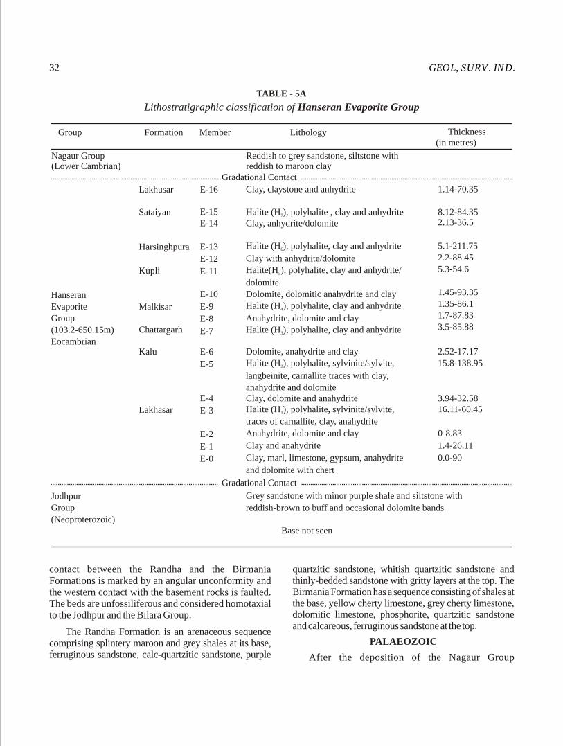
GEOL, SURV. IND.32
contact between the Randha and the Birmania Formations is marked by an angular unconformity and the western contact with the basement rocks is faulted. The beds are unfossiliferous and considered homotaxial to the Jodhpur and the Bilara Group.
The Randha Formation is an arenaceous sequence comprising splintery maroon and grey shales at its base, ferruginous sandstone, calc-quartzitic sandstone, purple
quartzitic sandstone, whitish quartzitic sandstone and thinly-bedded sandstone with gritty layers at the top. The Birmania Formation has a sequence consisting of shales at the base, yellow cherty limestone, grey cherty limestone, dolomitic limestone, phosphorite, quartzitic sandstone and calcareous, ferruginous sandstone at the top.
PALAEOZOIC
After the deposition of the Nagaur Group
TABLE - 5A
Lithostratigraphic classification of Hanseran Evaporite Group
Group Formation Member
Nagaur Group (Lower Cambrian)
Lithology Thickness(in metres)
Reddish to grey sandstone, siltstone withreddish to maroon clay
Gradational Contact
Lakhusar
Sataiyan
Harsinghpura
Kupli
Hanseran
Evaporite
Group
(103.2-650.15m)
Eocambrian
Malkisar
Chattargarh
Kalu
Lakhasar
Jodhpur
Group
(Neoproterozoic)
Gradational Contact
E-16
E-15E-14
E-13
E-12
E-11
E-10
E-9
E-8
E-7
E-6
E-5
E-4
E-3
E-2
E-1
E-0
Clay, claystone and anhydrite
Halite (H ), polyhalite , clay and anhydrite 7
Clay, anhydrite/dolomite
Halite (H ), polyhalite, clay and anhydrite 6
Clay with anhydrite/dolomite Halite(H ), polyhalite, clay and anhydrite/5
dolomiteDolomite, dolomitic anahydrite and clay Halite (H ), polyhalite, clay and anhydrite4
Anahydrite, dolomite and clayHalite (H ), polyhalite, clay and anhydrite3
Dolomite, anahydrite and clayHalite (H ), polyhalite, sylvinite/sylvite,2
langbeinite, carnallite traces with clay,anahydrite and dolomiteClay, dolomite and anahydriteHalite (H ), polyhalite, sylvinite/sylvite,1
traces of carnallite, clay, anahydrite
Anahydrite, dolomite and clay
Clay and anahydrite
Clay, marl, limestone, gypsum, anahydrite
and dolomite with chert
Grey sandstone with minor purple shale and siltstone with
reddish-brown to buff and occasional dolomite bands
Base not seen
1.14-70.35
8.12-84.352.13-36.5
5.1-211.752.2-88.455.3-54.6
1.45-93.351.35-86.11.7-87.833.5-85.88
2.52-17.1715.8-138.95
3.94-32.5816.11-60.45
0-8.83
1.4-26.11
0.0-90
MISC. PUB. No. 30 (12) 33
(Proterozoic), there was a break in sedimentation as a result of which sediments of most of Cambrian, Ordovician, Silurian, Devonian and Lower Carboniferous periods are not represented in Rajasthan.
Upper Carboniferous glaciation is represented in the Nagaur basin by the NE-SW trending remnants of the Bap Boulder Bed - an assortment of pebbles and cobbles with occasional boulders and a few erratics exhibiting well-marked glacial striations, spread over 68 sq km from Khirwa to Nokhra. The rock types include gravel/boulder (5 cm to 25 cm across in size) of rhyolite, tuff, granite, basalt and dolerite of the Malani Igneous Suite; granite, syenite, amphibolite and basic rocks, quartzite, phyllite and slate of pre-Delhi and Delhi age and limestone, dolomitic limestone and sandstone of the Marwar Group.
This is oveorlain by a very small remnant of the marine Badhaura sandstone of 30 m computed thickness. Extending from northwest of Badhaura upto Harbans, these marine sediments, designated as the Badhaura Formation, comprise medium to coarse-grained brownish-yellowish and ferruginous sandstone, clay, shale and siltstone containing Permian fauna and flora. The sub-surface continuation of the formation at Pugal between depths of 500 and 590m, and at Shumarwali Talai, has been established by drilling. The Permian sediments thus have thickened dipwards and represent the post-glacial sediments. The Badhaura sandstone which can be correlated with the sequence of the Indus Basin implies that the Indus Basin (Salt Range) was connected with the north and northwest Rajasthan.
MESOZOIC AND CENOZOIC
Deccan Traps
The Deccan Traps (Cretaceous to Eocene) covering an area of about 10,435 sq km in southeast Rajasthan have developed in two separate geographic sectors, namely, the Kota-Jhalawar sector in the southeast and the Chittorgarh-Banswara sector in the south- southeast.
Kota-Jhalawar sector: In this sector, the Deccan Traps overlying the Vindhyan sediments have attained a cumulative thickness of over 180 m. twelve flows, varying in thickness from 7 to 56 m are present between 280 and 481 m RL. Out of the 12 flows, five are Pahoehoe-type and the rest are Aa-type.
The individual flows are separated either by impersistent red bole bed or by Inter-trappean Beds comprising conglomerate, clay and chert. Both
fossiliferous and unfossiliferous clay/chert beds are present among the older flows. Physa prinsepii and ostracodes have been recorded near Parbati (24°23': 76° 31'), Sohankheri (24°30': 76°05') and Gadiyo (24°31': 76°03'). Around Dag (23°56': 75°50') and Chaumahala (23°57': 76° 36'), the flows have undergone widespread lateritisation. A gritty, sandy and cherty unfossiliferous friable Infra-trappean clay bed containing angular pieces of sandstone occurs widely in the area around Chippabarod (24°33': 76°43'), Chabra (24°40': 76°51') and Chandloi (24°30': 76°10').
Chittorgarh-Banswara Sector: The area is characterized by the N-S trending Deccan Traps plateau with prominent scarp on the west. The Deccan Traps overlie the Lower Vindhyan rocks in the north and northeast, but towards the west and south they rest over the rocks of the Mangalwar Complex and the Aravelli Supergroup. In all, sixteen flows varying in thickness from 11 to 55 m have been identified between 226 and 606 m RL. Out of these, four flows have Pahoehoe characters and the rest Aa-type characters.
Fairly widespread unfossiliferous clay bed, as Infratrappean, is present around Kushalgarh (23°12': 74°27') and Barodia whereas fossilliferous Physa (Bullinus) prinsepii Infra-trappean limestone bed is reported from Ram-ka-Munna in Banswara district. Unfossiliferous thin inter-trappean clay beds are noticed around Arnaud (23°53': 74°49') Dhamotar (24°06': 74°45') and Kulmipura (24°07': 74°45') whereas unfossiliferous chert bed, about 1 m in thickness is noticed near Acheri (24°26': 74°50') and Semara (24°26': 74°42').
The Deccan Traps do not show any sign of major deformation. However, columnar joints, sheet joints, pipe vesicles/amygdules are common. The flows in either sector have a gentle gradient and as such they occur at different levels. In Jhalawar-Kota sector, the contact gradient is 1:62 to 1:1050 towards NNW and NE and 1:250 to 1:500 towards NE and NW in Chittaurgarh-Banswara sector. Overlapping of flows is common in both the sectors.
From the correlation of flows in two sectors it appears that in all 19 flows are present in Rajasthan.
Tertiary Alkaline Complex
The Tertiary Magmatic event of the western Rajasthan is characterized by the midly alkaline and hyperalkaline plutonic-volcanic suites of Sarnu-Dandali, Karara-Tavidar and Mundwara areas. The

GEOL, SURV. IND.34
hyperalkaline suite of rocks clearly traverses the Malani rhyolites and Cretaceous clastics and, therefore represents a major Tertiary alkaline magmatic event. The Sarnu-Dandali suite is dominantly nephelinitic in composition, various members being mafic alkaline rocks, ijolites, foidal syenites, phonolites and carbonatites belongining to a carbonatite-nephelinite association. The Mundwara suite is mostly basic comprising picrites, foidal gabbros and foidal syenite with carbonatites which intrude the Erinpura Granite.
Sedimentaries
Triassic rocks do not outcrop anywhere in west and northwest Rajasthan but its subsurface presence, identified on pollen-spore assemblage, at Shumarwali Talai borehole, has been established. Land conditions existed during post-Permian to pre-Jurassic period and extensive erosional agencies reigned supreme leaving only traces of these Permian deposits. The Jurassic period commenced with a fluviatile environment which gave rise to the Lathi sandstone.
The area north, west and south of Lathi was filled up by the sediments of the Lathi Formation, the southern continuity being checked by the Jodhpur-Pokaran-Chotan-Malani ridge. The outcrops of the Lathi sandstone are seen intermittently, separated by the desert sands. The Lathi sandstone, 360 m thick, comprises a sequence of coarse-grained sandstone, gritty sandstone, pebbly sandstone, gritty and pebbly sandstone, conglomerate, arkose, lithic-arenite, siltstone, shale ferruginous shale, ferruginous sandstone and clay.
The Lathis overlie the Malani Igenous Suite of rocks, the Pondlo dolomite, the Nagaur sandstone, the Bap Boulder Bed and the Badhaura sandstone. The contact with the Malanis is marked by a conglomerate bed, grading into pebbly sandstone and grit. A friable, weathered, dirty-white to yellowish sandstone comes in contact with the other older underlying rocks.
The Lathi sandstone has been subdivided into lower and upper members. The lower member comprises a sequence of conglomerate, arkose, lithic-arenites and coarse-grained sandstone, indicative of terrestrial deposition under stable delta in fresh water conditions. The upper member comprises bands of sandstone and siltstone, grading into limestone, indicating shallow marine shelf-sedimentation.
The abundance of fossil wood logs is so conspicuous that an area near Akal has been converted
into a Fossil Wood Park. The fossil wood is of gymnospermous origin. The Lathi sandstone has leaf impressions of Pterophyllum sp. Pterophyllum acutifolium, Equisetites sp. and preserves silicified wood and gastropod shells. The Lathi sandstone contains thin bands of lignite as noted in dug wells near Devikot, Nar Singh-ki-Dhani, Jhinjhinyali and south of Unror.
The Mayakar Formation, which overlies the Badhaura Formation with an unconformity, has been equated with the Lower Lathis.
The deposition of Lathi/ Mayakar Formation culminated with the initiation of the marine transgressions in different basins. These include the Jaisalmer basin in the west, the Barmer basin in the south-central and the Palana-Ganganagar Shelf in the north and northwest of Rajasthan.
Jaisalmar Basin
The Jaisalmer basin deepened towards northwest extending into Pakistan. The Jaisalmer-Mari arch, the raised platform, exposes the entire sequence.
The Mesozoics are preserved in NE-SW trending strips with their northwesterly boundaries being located near Niba, Sam, Kanoi, Mahmud-ki-dhani, Jaidesar, Sanu and Lila; the Lower Tertiaries are exposed towards northwest of these localities. The Mesozoics are represented by the Lathi sandstone, Jaisalmer limestone, Baisakhi shale, Bedesar sandstone, Parihar (Pariwar) sandstone and Abur limestone, while the Lower Tertiary includes Sanu sandstone, Khuiala limestone and Bandah limestone. Pleistocene Shumar grits overlie the Lower Tertiary sequence as capping of ferruginous grit and laterites. All these units have been assigned formational status (Table-6).
The Jaisalmer limestone has intertonguing contact with the underlying Lathis and represents the first marine transgression of the Mesozoics in Rajasthan. Subsurface thickness of this formation is ~600 m in the Jaisalmer basin. The Baisakhi shale and the Bedesar sandstone occur as mappable rock formations of 165 m and 65 m thickness respectively, but in subsurface they occur as intergrading sequences. Each of these formations has been subdivided into units A, B and C. The overlying Pariwar sandstone which represents continental deposition contains angiospermic plant remains and is 300 m thick. The overlying Abur limestone marks the end of the Mesozoic Era in the
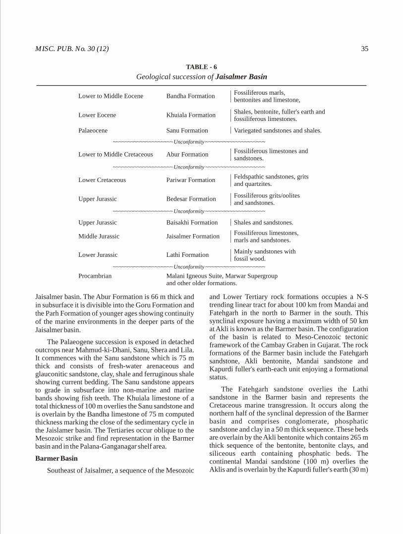
MISC. PUB. No. 30 (12) 35
Jaisalmer basin. The Abur Formation is 66 m thick and in subsurface it is divisible into the Goru Formation and the Parh Formation of younger ages showing continuity of the marine environments in the deeper parts of the Jaisalmer basin.
The Palaeogene succession is exposed in detached outcrops near Mahmud-ki-Dhani, Sanu, Shera and Lila. It commences with the Sanu sandstone which is 75 m thick and consists of fresh-water arenaceous and glauconitic sandstone, clay, shale and ferruginous shale showing current bedding. The Sanu sandstone appears to grade in subsurface into non-marine and marine bands showing fish teeth. The Khuiala limestone of a total thickness of 100 m overlies the Sanu sandstone and is overlain by the Bandha limestone of 75 m computed thickness marking the close of the sedimentary cycle in the Jaislamer basin. The Tertiaries occur oblique to the Mesozoic strike and find representation in the Barmer basin and in the Palana-Ganganagar shelf area.
Barmer Basin
Southeast of Jaisalmer, a sequence of the Mesozoic
and Lower Tertiary rock formations occupies a N-S trending linear tract for about 100 km from Mandai and Fatehgarh in the north to Barmer in the south. This synclinal exposure having a maximum width of 50 km at Akli is known as the Barmer basin. The configuration of the basin is related to Meso-Cenozoic tectonic framework of the Cambay Graben in Gujarat. The rock formations of the Barmer basin include the Fatehgarh sandstone, Akli bentonite, Mandai sandstone and Kapurdi fuller's earth-each unit enjoying a formational status.
The Fatehgarh sandstone overlies the Lathi sandstone in the Barmer basin and represents the Cretaceous marine transgression. It occurs along the northern half of the synclinal depression of the Barmer basin and comprises conglomerate, phosphatic sandstone and clay in a 50 m thick sequence. These beds are overlain by the Akli bentonite which contains 265 m thick sequence of the bentonite, bentonite clays, and siliceous earth containing phosphatic beds. The continental Mandai sandstone (100 m) overlies the Aklis and is overlain by the Kapurdi fuller's earth (30 m)
TABLE - 6
Geological succession of Jaisalmer Basin
Lower to Middle Eocene Bandha FormationFossiliferous marls,bentonites and limestone,
Lower Eocene Khuiala FormationShales, bentonite, fuller's earth andfossiliferous limestones.
Palaeocene Sanu Formation Variegated sandstones and shales.
Unconformity ~~~~~~~~~~~~~~~~~~~~ ~~~~~~~~~~~~~~~~~~~~
Unconformity ~~~~~~~~~~~~~~~~~~~~ ~~~~~~~~~~~~~~~~~~~~
Unconformity ~~~~~~~~~~~~~~~~~~~~ ~~~~~~~~~~~~~~~~~~~~
Lower to Middle Cretaceous Abur FormationFossiliferous limestones and sandstones.
Lower Cretaceous Pariwar FormationFeldspathic sandstones, gritsand quartzites.
Upper Jurassic Bedesar FormationFossiliferous grits/oolitesand sandstones.
Upper Jurassic Baisakhi Formation Shales and sandstones.
Middle Jurassic Jaisalmer Formation Fossiliferous limestones,marls and sandstones.
Lower Jurassic Lathi Formation Mainly sandstones withfossil wood.
Unconformity ~~~~~~~~~~~~~~~~~~~~ ~~~~~~~~~~~~~~~~~~~~
Procambrian Malani Igneous Suite, Marwar Supergroupand other older formations.
GEOL, SURV. IND.36
which marks the closure of Tertiary cycle in the Barmer basin.
Nagaur-Ganganagar Basin
Nagaur-Ganganagar Basin covers an area of 100,000 sq km in parts of Nagaur, Churu, Jaisalmer, Pali, Jodhpur, Bikaner, Hanumangarh and Ganganagar districts of Rajasthan and parts of Bhatinda, Faridkot districts in southern Punjab and parts of Sirsa district in Haryana.
The basin is delineated by Delhi-Lahore-Sargodha sub-surface ridge in the north and northeast, Aravalli Range in the east and southeast, Jodhpur-Pokaran-Chhotan-Malani ridge in the south and Devikot-Nachana sub-surface high in the west and southwest.
The oldest sedimentary rocks in Nagaur-Ganganagar Basin belong to the Marwar Supergroup (Neoproterozoic to Cambrian). The Marwar Supergroup consists of older arenaceous rocks of the Jodhpur Group overlain by the Hanseran Evaporite Group and its calcareous (Bilara Group) and phosphorite (Birmania Formation) facies variations and younger red argillaceous rocks of the Nagaur Group. It unconformably overlies basement rocks of the Malani Igneous Suite and / or the Delhi metamorphites and in turn is occasionally overlain by sediments of Permo-Carboniferous Bap-Badhaura Formations, lower Jurassic Lathi Formation, but mostly by Tertiary sediments associated with or without lignite and Quaternary sediments.
In west and northwest Rajasthan, the nearshore, lagoonal/estuarine deposits of Paleocene to lower Eocene age are important by virtue of the occurrences of lignite seams within them. These lignite bearing deposits are confined within the Palana Formation in Nagaur-Ganganagar basin, Akli Formation in Barmer basin and Sanu Formation in Jaisalmer basin. The detailed geological, geophysical studies of these Tertiary deposits are being carried out by various organizations due to the possible occurrences of oil, lignite, phosphate, bentonite and other varieties of clays.
Lignite occurrences are found associated with the lower Tertiary (Palaeocene to Eocene) Palana Shale Formation in Palana and Nagaur sub-basins of Nagaur-Ganganagar basin. The Palana Shale Formation comprises greenish grey variegated shales and clays associated with carbonaceous shale, shaly lignite and
lignite seams. At Palana, the Palana Shale Formation is represented by sandstone, clay, fuller's earth inter-bedded with limestone, lignite with partings of shale, mudstone and fine sandstone. At Gurha (40 km west of Palana), the sequence changes to coarse sandstone, fuller's earth, fine to medium grained sandstone, carbonaceous shale and lignite. At Barsinghsar (2 km away from Palana), thickness of lignite seam varies from 0.1m to 41.5m. Sedimentary facies change along with lignite seam thickness variation at different localities of Nagaur-Ganganagar basin shows that the types of sediments filling up the basin kept on changing, and this, along with availability of vegetation, palaeo-slope, palaeo-drainage etc. governed the thickness of the lignite seam in different parts of the basin.
Basement topography of Nagaur-Ganganagar basin reveals the presence of several basement highs and lows which are bounded and also dissected by N-S to NNE-SSW and E-W to ENE-WSW oriented faults. The N-S to NNE-SSW oriented faults gave rise to step grabens resulting deepening and more accretion of Tertiary sediments towards northwest and northern parts where lignite seams occur at deeper levels. These tectonic activities resulted in creation of isolated smaller sub-basins of Tertiary deposits with or without lignite seams.
The Tertiary sediments in Nagaur-Ganganagar basin successively overlap rocks of the lower Jurassic Lathi Formation, the Permo-Carboniferous Bap-Badhaura Formation and Neoproterozoic-Cambrian rocks of the Marwar Supergroup. They attain an average thickness of 150m in the Palana area. However, the cumulative thickness of sediments increases towards north and northwestern parts, particularly in Pugal-Karanpur sector where the sediment thickness is more than 420 m while in Lalgarh-Jattan-Maujgarh sector, the thickness is around 350 m. In the southern part of the basin, in Nagaur-Merta area, the average thickness of Tertiary sediments is 60 m.
The sub-surface data suggests that the Tertiary sea had transgressed the northwestern part of Nagaur-Ganganagar basin through two bays. The northern embayment extends in NNE direction along the Indo-Pak international border and adjoining the Nagaur basement high towards east. The southern embayment, coinciding with an E-W trending trough, which passes through Gurha, Sri Dungargarh and abuts against N-S trending Sardarshahar fault and swings southward and extends through the areas east of Nokha Mondi, west of

MISC. PUB. No. 30 (12) 37
Merta, near Matasukh and further south through the areas around Mugdasar, Phalki, Phalka and up to Jaitaran. The absence of Tertiary rocks and near surface occurrence of rocks of Marwar Supergroup at many places along the embayment is due to later tectonic activity.
Quaternary
The Quaternary sediments in Rajasthan are assorted deposits of aeolian, fluvial and lacustrine origin. They occur mostly in a large tract in western Rajasthan known as Thar Desert. The desert (area more than 2 lakh sq km) is delineated towards east by the NE-SW trending Aravalli Hills, towards north by the flood plains of the Ghaggar and Sutlej Rivers and in the south-west the Great Rann of Kachchh limits its further expansion. In the west comes the international India-Pakistan border, beyond which, the desert overlaps the older flood plains of the Indus River. Average elevation of the desert terrain varies from 150m to 300m MSL barring a few isolated hills rising 500 m above sea level. Outside the Thar Desert, the Quaternary sediments also occur in various fluvial basins.
The early Quaternary fluvial sediments in Thar Desert, found only at sub-surface levels, are deposited by organized drainage networks comprising major rivers of Himalayan origin (palaeo-Ghaggar-Saraswati) which were further strengthened by tributaries originating from Aravalli Uplands. These fluvial sediments were deposited initially, under high energy environment represented by polymictic conglomerates at the base, followed by repeated fining upward cycles of fluvial sediments interrupted by aeolian sediments and palaeosols. Successive onset of aridity resulted in the development of sag ponds mostly along the earlier fluvial channels and was also instrumental in subsidence of the fluvial topography and infilling by aeolian sediments.
The repeated phenomena of sand mobilization and accumulation under aeolian episodes with intermittent phases of dune stabilization were restricted to particular late Quaternary periods (Singhvi A.K. and Kar Amal, 2004). They were 200 Ka, 100-115 Ka, 75 Ka, 55 Ka and 25-30 Ka in late Pleistocene periods and 7-14 Ka, 3.5-5 Ka and 0.8-2 Ka in Holocene periods. Dune building activities had resulted in the formation of different dune forms controlled by the then prevalent wind intensity, direction, topography and vegetation. The study of dune
forms, their alignment bespeaks the control of SW monsoon wind in sand mobilization and accretion (Kar, 2004).
The onset of fluvial phase during the Holocene climatic optimum (6-7 Ka) had failed to develop drainage network in the heart of the Thar Desert, but nonetheless, the fluvial phase was responsible for the deposition of sediments along the Thar Desert fringe areas in the localized basins (graben like structures) within rocky uplands and also in areas of southern and south-eastern Rajasthan. They are Kantli-Ghaggar basin, Luni basin, Shergarh-Thob, Pokaran-Lawan, Kharotar-Kishangarh, Jaipur-Shapura areas, Banas and Chambal basins. The ubiquitous occurrences of older alluvium in the vast flood plain areas of these basins represent this second fluvial phase. The fluvial phase in Kantli-Ghaggar basin is represented by yellowish green, coarse to medium grained sand and sandy clay occurring below the calcrete/gypcrete pans. Similarly, the fluvial sediments are also occurring at the basal part of the Sambhar Lake.
During the third fluvial phase in Rajasthan, the earlier channel networks in localized basins were rejuvenated resulting deposition of younger alluvium along the river beds, banks etc. Successive remobilization of older stable dunes may be attributed to biotic interference.
Notable occurrences of minor minerals, construction materials within Quaternary deposits of Thar Desert are: fine to coarse fluvial sediments (Bajri), calcrete, gypsum and salts. Coarser fluvial sediments of grit, granule size admixed with finer fractions are used as construction material. Calcrete is used for road construction and also for lime washing village dwellings. Gypsum occurs at shallow depth, as cappings over Quaternary fluvial deposits spread over large areas in Barmer, Bikaner, Sri Ganganagar, Hanumangarh, Jaisalmer, Jalore and Nagaur districts of Rajasthan. Depending on the calcium sulphate content (CaSO .2H O %), gypsum is classified under four 4 2
grades, namely, i) above 90%, ii) 85-90%, iii) 80-85% and iv) less than 80%. High grade gypsum including selenite (crystalline variety) are sent to cement plants and also to units making plaster of Paris. Low grade gypsum is used for reclaiming alkaline soil. Different types of salts are extracted from saline lakes, particularly from Sambhar, Didwana and Pachpadra ,etc.

The regional strike of foliation in the BGC/Bhilwara and the Delhi Supergroups of rocks is dominantly NNE-SSW to NE-SW, while it is N-S and NW-SE in the Aravallis.
Large sca le reworking on account of polymetamorphism and migmatization (partial melting) has greatly obliterated the sedimentary and volcanic characers of the BGC. In addition, multiphase granitic activity and tectonic dislocations in the form of ductile and brittle shear zones trampled any semblance of stratigraphic order amongst the lithological units. Besides, hetereogenous deformation patterns in this vast expanse of BGC, a feature characteristic of large gneissic massifs, resulted in progressive deformation and deformation partitioning. Such heterogeneous deformation patterns have greatly impaired structural correlations of sampled areas, worked out by different workers, to a large extent. Most of the structural works are restricted to the western fringe of the BGC in the greenstone - granulite terrain because of higher density of outcrop population and metacratonic character of the terrain on account of its proximity to the Proterozoic Delhi - Aravalli Fold Belts.
The BGC terrain exhibits multiple deformation phases and superimposed folding. The BGC bears imprints of at least three phases of folding and associated shearing (Naha, 1983; Srivastava et al. 1995). In some sectors/areas, four phases of folding/deformations have been reported. Structural features and deformational history of the BGC often resemble with those in the Proterozoic cover sequences in the metacratonic parts. At places, however, an early folding episode (isoclines) and related planar and linear structures have been recorded in the BGC, which might represent deformational fabrics developed during the Archaean time. The regional foliation/schistosity is generally a transposed schistosity and appears as a composite foliation. The folds of the second phase are
isoclinal at many places. These folds are, in general, inclined to recline and are associated with axial plane crenulation cleavages, which in some sectors, have been transformed into schistosity in favorable rock types. The third phase of deformation has resulted in NNE-SSW trending folds with axial plane crenulation cleavages. The folds of the earlier phases and the planar and linear structures related to them are deformed by open cross folds of fourth and last phase of folding. These open folds and associated spaced cleavages are least pervasive. The regional amphibolite facies metamorphism and migmatization in the BGC is broadly coeval with the first phase of folding and deformation. Recrystallization is comparatively less intense during the second phase of folding whereas it is negligible during the latter phases of folding and deformation. In addition to the folding, the BGC terrain has been affected by multiple episodes of ductile and brittle shearing. As a result, occurrence of sheared-mylonitised rocks is a common feature in the BGC. In the BGC terrain, the rocks have undergone polymetamorphism, a feature recoganized as characteristic of the BGC rocks (Sharma, 1983; Sinha Roy et al. 1993; Gupta, 2004). This is in sharp contract to the Aravalli and Delhi Supergroup of rocks. Sharma (op. cit.) supposed that the BGC metasediments and metavolcanics have witnessed an orogeny prior to Delhi-Aravalli sedimentation. Sharma (op. cit.) and Gupta and Rai Chowdhuri (1996) also considered that the variation in the geochronological data vis-à-vis the temporal relationship between the structures and metamorphism is due to the progressive deformation and partitioning in the BGC rocks and is being explained as due to difference in tectonic levels of exposure at different places (Sharma op. cit.).
The structure of the Aravalli rocks was interpreted by Heron (1953) as controlled by upright folds on a NNE to NE trend. The Aravallis have undergone
Structure
38
Structure compiled by P. Gupta
MISC. PUB. No. 30 (12) 39
polyphase deformation resulting in complex fold interference pattern. It has been demonstrated that the Aravalli Supergroup has been deformed by four generations of folding. Out of these four generations, three fold generations (F to F ) represent the major 1 3
ones, which have affected the Aravalli rocks extending from Nathdwara in the north to Banswara in the south. In addition, Aravalli rocks also bear the imprints of a set of flat lying folds and crenulations and kinks at places. For the greater part of Aravalli Supergroup, the axial planes of the F and F folds are parallel or suparallel 1 2
indicating their co-planar geometry. F and F folds are 1 2
nearly co-axial and rarely Type 2 interference pattern (mirror image type) is observed, such as at Salumbar (Naha et al. 1988). Occasionally, the superposed folds have eyed geometry (Mukhopadhyay and Sengupta, 1979; Roy and Bejarniya, 1990). The second deformational structures indeed control the map pattern of the Aravlli-Fold Belt. Shallow dome and basin structures are formed by the interference of F and F 2 3
folds.
Roy and Nagori (1990) have suggested that much of the diversity in the structural pattern of the Aravallis is caused by shearing and heterogeneous reaction of the basement (BGC) and cover sequence (Aravallis) to the deforming forces.
The first deformational episode also produced a number of ductile shear zones. These shear zones are marked by razor-sharp contacts, displacement, truncation and asymmetric repetition of lithounits (Bhattacharya and Nagrajan, 1994), intense mylonitization (Paliwal, 1988) and development of S-C fabric and stretching lineation. Though some of these shear zones record strike-slip transposition, most of them are low angle reverse faults and indicate east to southeast direction of transportation. A prominent set of shear planes on regional scale developed during the second deformation event; their stretching lineation plunges at a low angle towards north suggesting a largely strike-slip movement. These shear planes can be recognized even in satellite imageries and aerial photographs accentuated by geomorphic features. The shear planes related to third deformation are widespread in space but regional in extent. Generally, the shear planes strike NE-SW and NW-SE with steep dip and overprint the earlier structures.
Mention may be made about the zone of parallel faults bounding isolated bodies of serpentinite. This fault zone is known as Rakhabdev Lineament which
represents a much younger deformation episode in the area (Barkatiya and Gupta, 1983). The Rakhabdev and Kaliguman lineatments, according to Sinha Roy (1998), represent zones of obduction of ophiolitic mélange within the Jharol turbidite sequence related to ensialic rifting and Aravalli trough opening which closed at Ca. 1.5 Ga.
Multiphase ductile shearing over the basement-cover interface between the BGC and the Aravalli rocks led to tectonic imbrication, e.g. near Delwara, in the Ora-Salumbar section and in the Dungarpur-Panuda section. Tectonic imbrication has caused interleaving of basement gneiss and cover sediments, close to the basement-cover interface.
The rocks of the Delhi Supergroup in the Alwar-Jaipur and Lalsot-Bayana basins exhibit folds of similar type and orientation. The regional folds are asymmetric, doubly plunging and show NE-SW striking axial planes. These doubly plunging folds have resulted in axial culminations and depressions. The earliest deformation has produced isoclines with NNE-SSW striking axial planes. Superposed on these first folds are sets of second generation folds, which are isoclinal, tight to open and have steep or vertical axial planes. These folds of the second generation control the map pattern. Folds of third generation are represented by cross folds producing culminations and depressions.
In the Khetri Fold Belt, Dasgupta (1968) recognized a number of longitudinal anticlines and synclines some of which show culminations and depressions. Gupta et al. (1998) have recognized two main phases of folding in the Proterozoic rocks in both the North Khetri and South Khetri Fold Belts. In the North Khetri Fold Belt, the earlier phase has produced isoclinal to tight folds with axes plunging gently towards SSE to SE with occasional reversal to NNW to NW. The later phase has produced upright to steeply inclined, close to open folds plunging gently towards SSW with occasional plunge reversal. In the South Khetri Belts, a series of steeply inclined antiforms and synforms plunging at a low to moderate angle towards NE or NNE and showing a dextral pattern belongs to the first phase. Due to the effects of ductile shearing, plunge and tightness of these folds increase as the shear zones are approached. During the second stage of deformation, open to close, upright folds have been produced showing moderate plunge towards NNE. These folds are associated with brittle shears, which run sub-parallel to their axial planes.

GEOL, SURV. IND.40
In the South Delhi Fold Belt, it has been opined by Gupta et al. (1991, 1995), Gupta and Bose (2000), Gupta (2004) and Mukhopadhyay and Bhattacharaya (2000) that SDFB is an ensemble of different tectono-stratigraphic units delimited by movement zones. These represent broadly coeval sub-basins, which were telescoped together during deformation. The dominant fold system throughout the belt has north-northwesterly striking axial planes and the plunge is in general low in the eastern segment but with gentle culminations and depressions; in the western segment the plunge is more variable. Multiple fold sets are present in both the segments.
Gupta et al. (1995), Gupta and Bose (2000) have recognized four phases of folding and associated shearing in the rocks of the Basantgarh, Barotiya, Sendra and Rajgarh Groups. The second and the third generation folds control the map pattern. In the Bhim Group, which lacks the earliest fold structure of Basantgarh, Barotiya, Sendra and Rajgarh Groups, the regional structure is an overturned F synform which 1
shows a sinuous outcrop pattern on account of superpositions of macroscopic dextral F folds.2
The Hindoli rocks are deformed in a series of ENE-WSW trending antiforms and synforms of isoclinal nature belonging to second phase of folding. Three phases of folding in the Jahazpur Group are correlatable across the folded unconformity with the last three phases of folding in the Hindolis; the earliest phase of folding in the Hindolis being absent in the Jahazpur Group. Though the first and second phases in the Hindolis are co-axial, the interference between the second and the third phases in the Hindolis produced crescent shaped Type-2 interference pattern of Ramsay (1967). This is in contrast to the co-axial pattern of deformation noted in the Delhis and the Aravallis. Metamorphism in the Hindoli Group has reached upto garnet-stauroltie grade (middle amphibolite facies). The developments of andalusite and anthophyllite are ascribed to the thermal event associated with subterranean granite plutonism.
The rocks of the Vindhyan Supergroup are very little disturbed and have gentle dips towards south and
south-southeast. The basement rocks beyond Chittorgarh in the west, Bundi-Indargarh in the northwest, and Shivpuri in the east acted as rigid block. The Ramgarh Dome acted as a centre from which the stresses were centrifugally radiated, resulting in the formation of Bundi-Indargarh and Phalodi anticlines in the northwest; causing a series of anticlines and synclines in Sawai Madhopur, Sapotra and Karauli areas in the north-northwest; generating open rolls in Shabad area in the east; forming Jhalawar anticline in the southeast and developing a series of anticlines and synclines in Chittorgarh in the west. The rejuvenation of adjoining Aravalli Delhi mobile fold-belt in the west resulted in the Great Boundary Fault (GBF) which trends roughly NE-SW for a distance of 400 km between Chittorgarh and Agra. It started as a gravity-fault along which gradual sinking of the basin floor took place. The present reverse geometry with low-angle thrusting has brought the older basement rocks in juxtaposition with the Vindhyan sequence. The GBF is not a single plane of disruption but it evolved in stages and represented a 10-20 km wide zone (Balmiki Prasad, 1984) comprising a number of parallel and oblique faults showing horst and graben features. Recent studies along the corridor of GBF carried out in Sawai Madhopur and Chittorgarh sectors suggest that it is not a marginal basin fault, but formed during syn to post deformation F folds. The 1
rocks under Marwar Supergroup of western Rajasthan are practically undisturbed except for the presence of north plunging main basinal synclinal axes trending N-S to NNW-SSE from Sojat to Bilara and Nagaur.
The Malanis were emplaced dominantly as fissure eruptions and accompanying sheet like intusions along NW-SE and N-S faults and fissures of post-Delhi age.
The rocks of the Mesozoic and Tertiary Era in the western Rejasthan are undeformed and constitute very low-dipping strata marked, at places, by gravity faults. The area being mostly covered by desert sand, the subsurface anomalies/discontinuities, revealed by geophysical and geological exploration by GSI, ONGC and other State agencies, indicate presence of a number of faults which have shaped the present disposition of the various lithounits in the area.
There is an established relationship between magmatism and orogenesis in the Earth's history. Each orogenic cycle has its own characteristic magmatic event also. In the geological record of Rajasthan, the following main magmatic events are recorded.
MAGMATISM IN BGC PROVINCE
Extrusives
In the south Mewar Plain, Bose et al. (1996) identified the following components in the BGC: (1) Tonalite gneiss and banded bimodal gneiss (3.3 Ga, Gopalan et al. 1990), (2) Enclave suite of igneous viz. mafic, ultramafic and felsic ( ~2.83 Ga, Gopalan et al. op. cit.) and sedimentary protoliths forming greenstone-type sequences lodged as dismembered units in succeeding granaites and migmatities, and (3) Granites and related migmatites of Gingla and coeval rocks (2.8 to 2.9 Ga; Choudhary et al. 1984). The tonalite gneiss and the bimodal gneiss are assigned the oldest status on the ground, that there is no reported presence of rock formations of the enclave suite (No.2) in these gneisses except the mafics which are apparently its protoliths (Bose et al. op. cit.). The banded bimodal gneiss and tonalite gneiss are exposed near Rajsamand (near Kankroli) in the central Rajasthan and occur as dismembered units in the latter granites and migmatites in the area south-southeast of Udaipur respectively. The banded bimodal gneiss is conspicuous by intercalations of two distinct modal units, basic and felsic and is considered to represent metamorphosed bimodal volcanic suite. Dark coloured layers rich in ferro-magnesian minerals alternating with light coloured quartz-feldspar layers have imparted the banded character to the gneisses.
The granite-greenstone sequences are generally intensely metamorphosed in the amphibolite facies and extensively granitized or migmatized in the sourthern and central Rajasthan. In central Rajasthan, the
greenstone sequences are divided into two stratigraphic groups (Mohanty and Guha, op. cit.): the older Sawadri Group and the younger Tanwan Group. The ultramafic rocks in the greenstone sequences are mainly represented by serpentinite, hornblendite, dunite, meta-peridotites, chlorite schist and talc-tremolite schist. Macro-spinifex texture is reported (Bhattacharya and Guha, 1988) from the ultramafic rocks where the mesostasis between the randomly oriented actinolite prisms (altered olivine?) is filled with glass. Spinifex texture is also identified in the ultramafics southeast of Udaipur (Bose et al. 1996). The basic volcanics represented by amphibolites contain vesicles, filled mainly with epidote and quartz, and rarely with calcite, and show sub-ophitic texture. The felsic volcanics occur as quartzo-feldspathic rocks and are conspicuous by the ubiquitos presence of pyrite in pockets and fractures.
The unaltered amphibolite samples contain 44.57 to 59.62% SiO and, in the silica-alkali diagram, the 2
majority plot in the subalkali basalt field, some in the andesite and the rest in the hawaiite field. Most of the samples contain less than 10% MgO and the rest contain 10.40 to 15% MgO. They are mostly olivine normative or are hypersthene and quartz normative. Chemical discriminants suggest them to be tholeiitic basalt. In FeO-MgO-Al O variation diagram (Pearce et al. 1977), 2 3
the amphibolites plot in ocean island field and close to the boundary of continental field. A few samples of amphibolites from the area near Nathdwara (Gopalan et al. 1990), which is the southern extension of the Sawadri Group, have low TiO and relatively high silica, 2
alumina, MgO, Ni and Cr contents. They are thus similar to basaltic andesites in many respects. The rare earth pattern suggests their derivation from basaltic parentage. The negative Eu anomaly is possibly a reflection of original source character. In the discriminant TiO -MnO-P O diagram, the amphibolites 2 2 5
plot in the transition zone of the IAT (Island Arc
Magmatism
41
Magmatism compiled by P. Gupta
GEOL, SURV. IND.42
Tholeiite) and CAB (Continental Alkaline Basalt) fields.
It has been observed that the older amphibolite (basic volcanics) occurring as restite in the gneisses of the Archaean crystallines have komatitic affinity. The granite gneisses show flat REE pattern and negative Sr and Eu anomalies similar to those of low alumina Archaean granites constituting a mature continental nucleus.
The Hindoli Group comprising an assemblage of mafic and felsic volcanics, altered tuffs with or without lapillis, forming in a repetitive sequence and interbanded with quartz arenite and chert, extends over a strike length of 30 km occupying low ridges from Kachola (25º 24' : 75º 07') in the southwest to Baripriyap (25º 46' : 75º 52') in the northeast; the thickness varies from 250 to 500m, the maximum being in the north of Ronija village (25º 42' : 75º 40'). At places, the volcanics are vesicular with infillings of quartz, calcite and pyrites. Presence of graded bedding and flute clasts in tuffaceous bands are indicative of its subaqueous condition of deposition.
The mafic volcanics, which are of basaltic andesite composition, include laths and rosettes of plagioclase (Ab -Ab ), clinopyroxene, quartz, glass, K-feldspar, 60 70
actinolite and zoisite. Ranging in composition from dacite to rhyodacite, the felsic volcanics contain long prismatic grains of sanidine and resorbed quartz embedded in an altered glassy groundmass. The glass is altered to quartz, sericite, chlorite etc. Flow bands swirl around the phenocrysts. Often lithic fragments, mostly of quartwacke, are aligned parallel to the flow bands. The fine to very fine-grained tuff contains glass fragments, plagioclase and ellipsoidal clasts of polycrystalline quartz, chlorite and a few grains of altered pyroxene. Sericite needles, likely to be an alteration product of glass, define the flow banding. The lapilli-bearing tuffs contain accretionary and armoured lappillis. The former types, 0.5 to 2 mm in diameter, are ellipsoidal or pancake-shaped, and are made up of altered glass. In the armoured lapillis, the kernels of the lithic fragments are rimmed by glass. These are of 2 to 10 mm in diameter.
Bose and Sharma (op. cit.), on the basis of the SiO 2
content and differentiation index (D.I.), categorized the volcanics into (1) basalts of 47-51.6 wt % SiO range 2
with 20-32 D.I. values, (2) Basaltic andesites of 53.68-55.53 wt % SiO range with 44-46 D.I. values (3) dacites 2
and rhyodacites of 61.2-67.15 wt % SiO range with 2
57.73 D.I. values. However, the overall SiO ranges of 2
47-55.53 wt % and 61.2-67.15 wt % ascribe a bimodal character to the Hindoli volcanics. Accordidng to Bose and Sharma (1992), high values of normative corundum in the felsic volcanics and the anomalous high values of Al O (upto 24%) and K O (6.2%) and low values of 2 3 2
CaO and Na O (20.1%) are due to subaqueous chemical 2
wathering.
Discriminant plotting in Al O vs. normative 2 3
plagioclase (Irvine and Baragar, 1971) and FeO vs. FeO/MgO diagrams (Miyashiro, 1974) suggests tholeitic nature to the mafic volcanics, which are largely quartz-normative with a few having olivine in the norm. A generally easterly increase in the content of SiO , 2
alkalis and TiO suggest a more differentiated nature of 2
the volcanics in the eastern part. MgO content varies erractically and is ascribed to crustal contamination of the ascending magma. In the TiO vs. FeO/MgO 2
(Glassley, 1974) and Ni vs. FeO/MgO (Miyashiro, 1974) tectonic discriminant diagrams, the samples plot in the Island Arc Tholeiite (IAT) field or island arc and continental margin field respectively, the samples with very high FeO/MgO ratio being exceptions.
Intrusives
During the tectonism in the BGC in Archaean period, a number of granite, granodiorite and tonalite plutons were emplaced. The granite bodies occurring at Untala, Gingla, Berach etc. represent such distinct granite plutons of Archaean age. Besides these Archaean granites, a number of granite bodies of younger age have been recorded viz. Anjana Granite, Gyangarh-Asind Charnockite-Enderbite, Banagarh Granite, Patan Granite, Jahazpur Granite, Garwar Granite, Dedulia Granite, Daulatgarh Granite, Ojagarh Granite, etc. Apart from the granites, the BGC terrain is also characterized by intrusives of carbonatites, acid granulites and mafic rocks belonging to different ages. In the following paragraphs, some of these major intrusives are described.
Untala and Gingla Granites
The Untala Granite is a lensoid body, which is about 30 km long and 10 km wide. It occurs between Wani in the north and Arinda in the south and is well exposed near Untala (renamed as Vallabhnagar) located 6 km north of Bhatewar on Udaipur-Chittaurgarh Highway, 35 km from Udaipur city. The granite shows a composite nature and consists of grey diorite-tonalite-trondhjemite gneiss and late pink/grey granite (Chattopadhyay et al.
MISC. PUB. No. 30 (12) 43
1987). The gneiss is medium to coarse grained, foliated and composed of quartz, plagioclase, K-feldspar and biotite with minor/accessory chlorite, sericite, muscovite, sphene, zircon, apatite, epidote, zoisite and opaques. It shows hypidiomorphic granular texture, whereas at places, it is geneissic. The K-feldspar is represented by microcline or string-type perthite and orthoclase. The plagioclase shows lamellar twining and is of oligoclase-andesine in composition. The late granite is medium grained, composed of quartz, plagioclase and K-feldspar with minor accessory biotite, muscovite, apatite, carbonates, sphene and opaques. It exhibits hypidiomorphic granular texture. The gneiss has low Rb and high Sr and low K/Rb ratio compared to late granite.
Crawford (1970) reported a Rb/Sr whole rock, muscovite and biotite isochron for the Untala Granite corresponding to an age of 955±50 Ma and an initial
87 86ratio Sr/ Sr of 0.7094 ±37. Choudhary et al. (1984) on the basis of whole rock Rb/Sr isochron of nine samples of Untala Granite, suggested the age to be 2920± 100 Ma. Gopalan (1986) suggested that there was an isotopic equilibrium around 900 Ma. According to Chattopadhyay et al. (1987), the grey gneiss represents the early Archaean tonalite-trondjhemite crust, i.e. the orthogenetic nuclei; and the younger phase has probably intruded around 2300 Ma and is correlatable with the Berach Granite (dated 2445±100 Ma; Choudhary, 1984). Roy and Kroner (1996) obtained an age of 2866 ± 6 Ma for trondhjemite gneiss, while Wiedenberk et al. (1996) obtained an age of 2025±5 Ma for the pink granite.
The Gingla Granite occurs around Jai Samand Lake (Dhebar Lake), which falls nearly 100 km southwest of Udaipur city. The Gingla Granite shows migmatitic and granitic components. The migmatite and granite components show gradational relationship. The luecosome in the migmatite consists of quartz and plagioclase with subordinate K-feldspar. Quartz, biotite, plagioclase and hornblende with accessory zircon, apatite and sphene constitute the melanosome. The component of granite in the Gingla body is mostly massive, hypidiomorphic granular. It shows phenocrysts of quartz and plagioclase set in a groundmass composed of quartz, plagioclase, biotite and hornblende with apatite, sphene and rutile as accessories. Bose et al. (1996) opined that the Gingla Granite is chemically comparable with orogenic granites.
Gyangarh-Asind Charnockite-Enderbite
The 1723+14/-7 Ma (Sarkar et al. 1989) old enderbite-charnockite forms a major pluton in the Sandmata area. Besides, it occurs in the Bhinai area and as centimeter to metrescale bands in leptynite in the Sandmata area. Enderbite and Charnockite are intermingled with each other. Massive Enderbite-Charnockite forms the major part of the pluton. At places, banded granodiorite is present as thin to thick bands within the pluton. A breakdown of charnockite to granodiorite is noted across the diffused and graded boundary and is amply demonstrated from the omnipresence of relict enderbite-charnockite within granodiorite. Enderbite is rarely foliated, and in the massive part, occasionally oriented prisms of pyroxene and feldspar define primary foliation of the igneous mass. Granodiorite is well banded and foliated, but its boundary with enderbite- charnockite part is not always parallel to the banding in granodiorite. The enderbite-charnockite contains quartz, plagioclase, K-feldspar, hypersthene, diopside, biotite garnet and hornblende. Apatite and tourmaline occur as accessories. The contact of enderbite-charnockite with different lithologies is marked by high strain zones. Still intrusive relationship is presered at several places. The field relationship has established that the enderbite-charnockite body has intruded the garnet-sillimanite gneiss as sheet-like body in the Sandmata area (Gupta and Rai Chowdhuri, 2002).
Raipur-Jalayan mafic rocks
Swarms of ortho-amphibolite, gabbro and norite with associated pyroxene-granulite intruding the rocks of the Sandmata Complex, and occurring in Akeran-Shokla Jalayan-Jodhwarpura, Karelia-Raipur-Rajgarh areas for over 136 km distance have been included in this suite.
In the Giyangarh, Rajgarh and Bhinai areas where these are associated with acid suite of rocks, they appear to be intimately related by virtue of common parentage. They have been grouped in the Sandmata Complex considering their relation with the syn to late tectonic activity (Gupta et al. 1980, 1999).
Berach Granite and Gneiss
The Late Archaean Berach Granite and Gneiss (2585 Ma, Crawford, 1970; 2445 ± 100Ma, Chaudhary et al. 1984), which has been referred as “Chittor Gneiss” by Crawford (1970), “Bundelkhand Gneiss” by Heron (1936) and Gupta (1934) and “Berach Granite” by
GEOL, SURV. IND.44
Pascoe (1968, 1973) and occurring from east of Pirana in the south to northeast of Kanti in the north, over a distance of 140 km with a maximum width of about 25 km in the middle, constitute the main outcrop of the Berach Granite and Gneiss. There are five more occurrences of these rocks in Achalpur-Nikum (22 km x 0.6 km); Bhaunja-Rajpura (10 km x 0.6 km); Chainpura-Karju (7 km x 0.4 km); west of Satola (0.6 km x 0.2 km) and Dholpuni-Nalwa (17 km x 9 km) areas. The best exposures of the Berach Granite are seen along the course of the Berach River.
Heron (1936) and Gupta (1934) correlated the Berach Granite with the BGC. The prevailing opinions regarding the contact relationship between the Berach Granite and the Hindoli Group (Gwalior Series of Heron, 1917) is somewhat divided. Heron (op. cit.), Gupta (1934), Sharma and Roy (1986) considered Berach Granite as forming the basement for the Hindoli Volcano-sediments. On the other hand, according to Balmiki Prasad (1987), the Berach Granite is a late tectonic, mesozonal emplacement into the adjoining meta-pelitic and associated semi-pelitic rocks of the BGC. Balmiki Prasad (op. cit.) has also identified syn-tectonic granite, named as Pipla-Jolar Granite, within the crescent-shaped outcrop, intruded during the regional metamorphism of the BGC rocks. Raja Rao (1967, 1970), Gupta et al. (1980), Sinha Roy (1985) and Sinha Roy and Malhotra (1989) also considered Hindoli Group as of Archaean age being intruded by the Berach Granite.
The western part of the granite in the main occurrence is gneissic. It is generally pink, non-foliated, medium-grained, and consists of opalescent quartz, potash feldspar, plagioclase and chlorite, exhibiting hypidiomorphic texture in thin sections. Berach Granite from north of Chittorgarh has been dated 2,585 Ma by Crawford (1970). It is now widely accepted that the Berach Granite represents the terminal stage of magmatic activity of the Archaean orogeny in the Late Archaean period. Sinha Roy (1985) opined that the Berach Granite belongs to the climactic phase of the processes of development of granite-greenstone sequence during the end of Archaean cratonisation event.
Balmiki Prasad (op. cit.) noted a compositional variation across the granite body, in which pink-coloured, non-foliated, medium-grained granite in the eastern part grades into gneissic granite towards the west. However, no such gradations are noted by Sharma
et al. (op. cit.) and instead have recognized two granite phases. The older foliated granodiorite is hypidiomorphic granular, medium to coarse grained and contains quartz (generally 15 to 20%), orthoclase (less than 10%), microcline, plagioclase (An -An , 37 to 50 60
60%), biotite, muscovite and occasionally hornblende as main mineral modes. Sphene, apatite, magnetite, zircon and epidote occur as accessories. On the quartz-alkali feldspar-plagioclase diagram, the samples plot in the garnodiorite, tonalite and sometimes quartz-monzo-granodiorite field.
The younger phase of the Berach Granite is sensu stricto, granitic in composition and occurs mostly on the eastern part of the massif. The younger phase is more alkali feldspar rich, medium to coarse grained, hypidiomorphic granular. Quartz (20-25%), K-feldspar (20-40%), plagioclase (An -An ) and biotite are the 20 30
chief constituents, while sphene and apatite are the accessories.
Jahazpur Granite
The Jahazpur Granite occurs between north of Tola and north of Umat over a length of about 22 km with width of about 3 km. The Jahazpur Granite is a composite granitoid body composed of older grey granite and younger pink granite. Quartz, soda feldspar and biotite together with varying amount of potash feldspar constitute the grey granite phase which has a distinct gneissic foliation. Hornblende, actinolite and opaque minerals along with zircon and apatite form the accessory constituents. The composition is close to tonalite with plagioclalse dominating over quartz. The younger pink granite, intrusive into the grey granite, is mineralogically of alkali granite composition and includes quartz, perthite and orthoclase, and minor biotite, apatite and opaques. The rock shows hypidiomorphic granular texture. According to Gupta et al. (1980, 1997), the Jahazpur Granite is intrusive into the rocks of the Umar Foramation of the Jahazpur Group. However, Sinha Roy (1984, 1985) considered the Jahazpur Granite as forming the basement over which the Jahazpur Group of rocks was deposited. Malhotra and Pandit (2000) correlated the pink granite phase of the Jahazpur Granite with the Berach Granite (~ 2.6 Ga).
Kishangarh Syenite
A unique occurrence of an interesting suite of nepheline syenite bearing alkaline suite, without any counterpart in the east of the Aravalli mountain range, is

MISC. PUB. No. 30 (12) 45
recorded in the area around Kishangarh-Patan-Harmara, ENE of Ajmer, close to the ductile shear zone marking the boundary of the BGC with the Delhi Supergroup of the South Delhi Fold Belt. The syenite suite consists of one large intrusion and seven small sill-like bodies. Kurien (1951) considered it post-Aravalli intrusive. Basu (1961) considered the Kishangarh syenites as post-Delhi intrusives. The syenite at Harmara consists of nepheline, K-feldspar, plagioclase and hornblende with a little sphene and apatite. The outcrops of syenite occurring north and south of Ajmer-Jaipur road show a central, massive body passing through banded-type to foliated variety near the margin of the body. The isolated hill, northwest of Tilonia, is made up of syenite consisting of garnet, biotite and hornblende in addition to other essential minerals. Near Mandoria, the rock suite also includes theralite and comptonite (Basu, op. cit.). The theralite occurs as xenoliths within the nepheline syenite whereas the comptonite occurs as dykes in the nepheline syenites. Theralite is composed of clinopyroxene, amphibole, biotite, K-feldspar, plagioclase and nepheline. Sphene occurs as accessory. The principal clinopyroxene is titaniferous augite.
The alkaline rocks at Kishangarh are generally associated with gabbro (Niyogi, 1965). In general, the syenites contain equal proportions of nepheline and plagioclase (andesine) with subordinate amount of magnesian amphibole (magnesio-riebeckite), biotite and sodic pyroxene. Niyogi (op. cit.) opined that syn to late tectonic alkali metasomatism of gabbro has generated the syenites of Kishangarh area.
Roy and Dutt (op. cit.) interpreted the nepheline syenite body as diapirically emplaced katazonal pluton. The emplacement presumably took place during the opening of the Delhi rift-basins in the west.
Crawford (1970) has given a three-point Rb/Sr isochrone age of nepheline syenite at 1490 ± 15 Ma, which is correlatable with the metamorphism of the nepheline syenite. The model age of 1910 Ma (Roy and Dutt, 1995) of single sample of nepheline syenite was interpreted as the emplacement of the nepheline syenite pluton (Roy and Dutt, op. cit.).
Newania Carbonatite
A large elliptical body of carbonatite (3 km in length and 50 m to 1.2 km width) along with a number of carbonate dykes and veins within Untala Granite occurs 1 km northeast of Newania, Udaiput district. It is light-
grey, medium to coarse-grained and consist predominatly of calcite and biotite with minor tremolite and actinolite. It varies in composition and is represented by rauhaugite, beforesite, minor sovite and lapilli carbonatite. Distinct zone of fenitisation has developed around the pluton. Chattopadhyay et al. (1988) considered it as a funnel shaped intrusion along E-W axial traces of low-plunging folds.
According to Golani and Pandit (1999), the ankeritic (1551 Ma Pb/Pb age; Schleicher et al. 1997) and veins of calcite carbonatites are hydrothermally emplaced into the magnesian carbonatite (2.27 Ga age: Schleicher et al. 1997) variety in an epithermal environment. These radiometric ages are in contradiction to the earlier determined age of 959 ± 24 Ma (Deans and Powell, 1968).
Rock similar to the carbonatite (5x2 m to 10x5 m) also occur 0.8 km west and 1.2 km N 35° W of Vallabhnagar railway station amidst the Untala Granite. It is dark-brown in colour, fine to medium-grained, laminated and consists of calcite, apatite, phlogopite and biotite with minor amounts of hornblende, muscovite, limonite, goethite and haematite.
Dolerites and Ultramafics
Dolerities occurring at several places as sills within the Bhadesar Formation and as dykes in the Hindoli Group of rocks are referred to as Hindoli Dolerites. These are melanocratic, medium-grained rocks. Xenoliths of these dolerites are reported from the Berach Granite and Gneiss.
Altered ultramafic intrusives occur as talc-chlorite schist in an isolated thin zone between northeast of Pipalkhunt and northwest of Jolar for over 28 km within the Manglwar Complex, besides small isolated outcrops near Barana, Nawalia within the Sand Mata Complex.
Dark-green, medium-grained, jointed dolerites exposed around Bari Sadri, Hora and Mandalgarh are younger than the Hindoli dolerites and occur as sills and dykes intruding the rocks of Ranthambhor Group. The stratigraphic position of these dolerites is uncertain.
MAGMATISM IN ARAVALLI-DELHI PROVINCE
Aravlli - Fold Belt
The Aravlli - Fold Belt witnessed three main events of magmatism. These were an extensive syn-sedimentational basic volcanism named as Delwara-
GEOL, SURV. IND.46
Siri Volcanics, emplacement of Rakhabdev Ultramafic Suite of rocks and emplacement/intrusion of Darwal, Udaipur (Ahar River), Titri, Udaisagar and Salumber granites.
Extrusives
Delwar-Siri Volcanics
These comprise a thick pile of synsedimentrary basic meta-volocanic flows of varying thickness with 1 m to 100 m thick inter-trappean beds of quartzite and ferruginous cherts. The volcanics are exposed from Untrol in the north to south of Phalet over a tract of 50 km in Debari sector between Umra and Chanda in Jaisamand sector and further south of Jaisamand lake area in the Boraj, Anjani, Gagari, siri, Parsola, Rohina Manik and Waori Khera areas over a distance of 70 km. These rocks have attained greenschist facies of regional metamorphism. The mineralogical assemblages noted are actinolite + plagioclase (oligoclase) + epidote, actinolite + oligoclase + epidote + chlorite + opaque ± sphene ± rutile, and hornblende + oligoclase + chlorite + biotite + opaques. The rock shows glomeroporphyritic and subophitic textures. Vesicles are filled with secondary cryptocrystalline silica, carbonate and epidote. In the chemical discriminant diagrams, the volcanics plot across basalt, basaltic andesite, andesite and trachyandesite fields, although they are mostly concentrated in the basalt field. According to Gupta et al. (1980), spatial distribution of these volcanics at the base of the Aravlli Supergroup (Delwara formation) along a NW-SE linear belt suggests that their eruption was controlled by a deep seated, mantle tapping and fundamental fracture now designated as the Delwara Lineament.
Rakhabdev Ultramafic Suite
The ultramafic rocks occur in Antaliya-Rakhabdev-Kherwara-Dehlana areas as large, irregular lensoid bodies of more than 5 km length within the Aravlli Supergroup of rocks in three different belts. The first belt extends from Dad in Dungarpur district in the southeast to Sero-ki-Pali in the north over a distance of 77 km, the second from Kanthria to Kaliguman over a distance of 115 km and the third from Kuanthal to Titri over a distance of 15 km. In the Antaliya area the ultramafic bodies are very small, lense or oval shaped.
The rocks are predominantly serpentinite and extensively altered by metamorphism to talc-carbonate rocks, talc and chlorite schists. According to Gupta et al. (1980, 1990), these are considered to have intruded
concordantly between the litho-contacts of the Jharol and the Dovda Groups, and the Lunawada Group, before and during the first phase of Aravalli folding. The occurrence of the ultramafic suite of rocks along the Rakhabdev and the Kaliguman Lineaments indicate that these deep-seated fractures might have tapped the mantle source. Patel and Mehr (1967) considered the ultramafics bodies to have been intruded during the terminal phase of the Aravalli sedimentation while Sychanthovang and Desai (1977), Sen (1981), Sinha Roy (1988) regarded these ultramafics bodies to represent obducted oceanic crust. Yet also, the ultramafics suite of rocks are considered 'cold emplacement' along a zone of rifting by Chattopadhyay and Gangopadhyay (1981) or as deeper cumulates of the basal Aravalli meta-volcanics by Srivastava (1988).
Intrusives
Darwal Granite
Darwal Granite, emplaced in a fold-closure of Aravalli rocks, occurs over a distance of 32 km from south of Darwal to northeast of Paroli. The width varies from 200 m to over 5 km. It is grey, coarse grained, biotite-rich granite showing hypidiomorphic granular texture in general but gneissic at places. The granite is composed chiefly of quartz, K-feldspar, plagioclase and biotite. Muscovite, chlorite, sphene, calcite and allanite occur as accessories.
The Darwal Granite has been dated at 1900±80 Ma (Choudhary et al. 1981) and is considered by Gupta et al. (1980, 1997) as Early Proterozoic, syn-kinematically intrusive into the rocks of Aravlli Supergroup.
Udaipur Granite
The Udaipur Granite (also known as the Ahar River Granite) is exposed in a roughly triangular area northwest of Udaipur and extends from Chota Hawla in the south to Barora in the north and from Madar in the west to Bhilara in the east. It is a medium to coarse grained, pinkish to greenish-grey, porphyritic (occasionally gneissic also) granite which grades into finer aplitic forms along margins. It is composed of quartz, plagioclase-feldspar, muscovite and sericite. Magnetite, pyrite, apatite, zoisite, calcite and epidote are accessories. According to Sahu et al. (1991), it is two phase granite, viz. grey granite (tonalite) and pink granite (granodiorite).
The Udaipur Granite has been dated at 2026 Ma (Sarkar et al. 1992). Wiedenbeck et al. (1996) obtained

MISC. PUB. No. 30 (12) 47
2566.2 Ma age of grey granite phase of the Udaipur Granite and interpreted this age to represent the time of crystallization of the granite.
Titri Granite
Titri Granite occurs in an area over 3.5 km in length from Eklingpura in the north to Phanda in the south and about 1.8 km in width from Titri in the west to Bhola in the east. Although the granite is massive in greater parts, it is foliated near the contact with meta-sediments and has caused feldspathisation. It consists of pink, grey and cream coloured feldspars, translucent quartz, biotite and chlorite.
Udaisagar and Dakan Granitoids
Udaisagar Granite occurs as isolated outcrops from north of Dakan Kotra to Udaipur and west of Jaisamand. The Udaisagar boss is about 8 km in length with an average width of about 2 km. It is white, aplitic, medium-grained and nonporphyritic granite. In the Udaisagar Granite, two phases have been identified. The pink granite represents the older phase, while the younger phase is represented by a leucocratic aplogranite. The pink granite is composed chiefly of oligoclase, K-feldspar, quartz, biotite and muscovite with sphene, apatite and opaques as accessories. The leucograntie consists of quartz, microcline and plagioclase with minor muscovite, epidote, sericite, apatite and opaques. In some outcrops, the Udaipur Granite is gneissic in nature.
Salumber Granite
Salumber Granite occurs intermittently between north of Sanjela and east of Balawa over a distance of 70 km. It is in general a leucocratic, medium-grained, non-porphyritic granite comprising translucent quartz, orthoclase, microcline, oligoclase and muscovite, and in some cases biotite or tourmaline.
North Delhi Fold Belt and South Delhi Fold Belt
Two main phases of magmatism are noted in the North Delhi Fold Belt and South Delhi Fold Belt. The first phase involved syn-sedimentational volcanism and second one relates to the granitic intrusions.
North Delhi Fold Belt
Extrusives
Volcanics within the Raialos have rift-related tholeitic to alkali olivine basalt affinity with signs of explosive volcanism (Banerjee & singh, 1977). Gupta
and Sharma (1998) noted evidences of volcanism in the Ajabgarh sequence. The volcanism, which is syn-sedimentary, started with the onset of deposition of the Kushalgarh sediments and continued intermittently throughout the duration of the Ajabgarh sedimentation. Except for the middle Ajabgarh, where it is bimodal, the volcanics are unimodal in character and increase in proportion towards the top.
The chemistry of basic volcanics at Jahaj-Govindpura area in the Bayana sub-basin (Singh, 1985) reveals large variation in SiO , MgO and K O. It is 2 2
suggested by Singh (op. cit.) that the flows are transitional between tholeiitic and alkali basalts. The basic rocks show a poorly defined differentiation trend. The volcanics resemble high K O continental tholeiites. 2
The tholeiites are characterized by enrichment of large ion lithophile elements (LILE) and light rare earth elements (LREE) and depletion of Nb, P and Sr (Raza et al. 2001). The values of TiO (1.06 to 2.31%), Zr (50 to 2
182 ppm), Ti/Y (286 to 521) and Zr/Y (2.63 to 5.70) are low, which suggest their close similarity with low-Ti continental flood basalts. Raza et al. (op. cit.) opined that the Bayana volcanics might have been derived from an enriched mantle source with no significant crustal contamination. It is also interpreted that the parental magma has been derived probably from a sub-continental lithospheric mafic source with Fe/Mg ratio exceeding that of model pyrolite. It is further suggested that the mantle source of these volcanics was enriched through metasomatism by progressive transport of mantle fluids and/or melts from deeper mantle. Olivine and clinopyroxene dominated the fractional crystallization and played a major role in the evolution of magma, following its derivation from shallow mantle source(s) where clinopyroxene occurred as a residual phase.
In the South Khetri Fold Belt, felsic volcanics with agglomerate, tuffs and volcanic breccias are present. Euhedral phenocrysts of plagioclase and quartz with or without orthoclase and muscovite, sometimes imparting a flow texture, are set in a fine grained matrix with glass material, biotite and muscovite. Phenocrysts of plagioclase, orthoclase and quartz show resorbed margins. The fine grained tuff is dark grey, finely laminated and often vesicular. The vesicles are 2 mm to 10 mm in diameter and are filled with soft friable or hard carbonaceous matter. In thin section, the rock is mainly composed of anhedral quartz set in a groundmass of quartz and sericite. The crystal tuff is also dark grey,

GEOL, SURV. IND.48
hard and porphyritic with 1-2 mm subhedral to euhedral white feldspars and cryptocrystalline quartz set against the dark grey groundmass with iron ore and possible manganese dust. Under the microscope, the rock has a well developed porphyritic texture defined by subhedral to anhedral quartz embedded in the medium grained devitrified groundmass with remnants of glass. Spherulitic texture is rarely seen (Gathania and Golani, 1988). The volcanic agglomerate and breccia are made up of lapilli and bombs of andesitic material, rectangular and squarish in shape, and welded by glassy matter with a biotite-rich groundmass. The volcanics plot in the rhyolite field in the discriminant diagrams.
Intrusives
Dadikar Granite
Dadikar Granite is exposed about 5 km northwest of Alwar town in a 4 km long and 2 km wide valley. The granite is leucocratic to mesocratic, medium to coarse grained and is two-feldspar (K-feldspar dominant) porphyroblalstic granite often showing augen texture. The mineral phases include quartz, microcline, plagioclase, biotite and muscovite. Plagioclase content generally increases towards the margin. The accessories include zoisite, apatite and zoned zircon. Two main types of granites have been recorded: (i) pink and foliated granite along the margins of the granite massif and (ii) grey or pink porphyritic type in the central portion (Banerjee, 1980). Apart from the presence of tongues and apophyses of the granite penetrating the Delhi metamorphites, the intrusive nature of the Dadikar Granite is manifested by the bulging of the strata on either side of the massif in the southern part. Occurring in the core of an antiform enveloped by the rocks of the Raialo Group, the relative status of the granite as an intrusive in the Delhis (Joshi, 1970, Gandhopadhyay, 1972) has been questioned by Chakraborti and Gupta (1990) who assigned a basement status to the Dadikar Granite. Crawford (1970) dated the age of one sample of Dadikar Granite to be 2100 Ma by whole rock isochrones. The rock has been also dated 1500-1700 Ma by Sastry (1992).
Ajitgarh Granite
It is an intrusive body emplaced in the core of Nayai syncline and is exposed for over 2 sq km area around Ajitgarh village, Sikar district. The emplacement of Ajitgarh Granite in the Alwar-Jaipur basin is said to be syn-kinematic with second phase of deformation (Roy and Das, 1985). The Ajitgarh Granite is a minor
composite granite pluton, which includes a predominant alkali granite (grey and pink varieties), and volumetrically subordinate leucocratic trondhjemitic granite (Pandit and Kataneh, 1998). Both the phases are medium to coarse-grained and show hypidiomorphic texture. The alkali granite has predominant alkali feldspar and quartz, with minor amounts of plagioclase, biotite, hornblende and titanite. The trondjemite granite contains predominantly quartz and plagioclase with minor amounts of alkali feldspar, amphibole and titanite. Zircon and magnetite form the accessory phases in both the granites. High abundance of SiO , alkalies, 2
high field strength elements (HFSE) and large ion lithophile elements (LILE) and low concentrations of MgO and CaO, high Fe/Mg and Ga/Al ratios (Pandit and Khataneh, 1998) indicate that the Ajitgarh Granite has A-type affinity. In the Ajitgarh Granite, analysis of euhedral zircons (by EPMA studies) from the trondjhemite phase yielded 1.725±0.013 Ga age and the zircons from the pink and grey alkali granite yielded closely comparable 1.719±0.013 Ga and 1.741±0.015 Ga ages respectively (Biju Sekhar et al. 2002).
Bairat Granite
The granite is exposed in a 4 km x 2.5 km area around Bairat village of Alwar district. The Granite has been dated 1500-1700 Ma. Occurring in the core of an antiform, the Bairat Granite is considered as intrusive and composite in nature (Heron, 1917; Sant and Sharma, 1973; Goswami and Ganopadhyay, 1971). Goswami and Ganopadhyay (op. cit.) delineated two types of granites: (i) foliated and lineated granite with mafic constituents and (ii) homophaneous pink granite with minor mafics. The foliated variety is white or pink, coarse to medium grained, inequigranular and porphyritic at places, consisting essentially of microcline, microcline-perthite, plagioclase (oligoclase), quartz with various proportions and combinations of biotite, hornblende, sphene, epidote, apatite, tourmaline and allanite. The non-foliated variety has similar mineralogy, but shows wide variation in texture and grain size. Goswami and Ganopadhyay, (op. cit.) grouped these granites as alkali granite and adamellite respectively. The foliated variety, according to them, is late syn-kinematic with the first phase of deformation of the Delhi rocks, while the non-foliated homophaneous pink variety is post-tectonic. One sample of the Bairat Granite has been dated at 1650 Ma by Rb/Sr whole rock isochrons (Crawford, 1970).

MISC. PUB. No. 30 (12) 49
Harsora granite
A cluster of granite bodies occupying 10 sq km area in and around Harsora village, Alwar district, is a syn to late kinematic emplacement of acid intrusion into the anticlinal fold closures formed by the Alwar-Raialo meta-sediments. Generally light coloured, medium to coarse grained; the hypidiomorphic Harsora granite contains large equi-dimensional grains of microcline, plates of lamellar-twined plagioclase and anhedral quartz with sutured boundary. Biotite, muscovite, zoisite, apatite and opaques form the accessories. Myrmekitic intergrowth between the plagioclase and uniformly arranged quartz grains are commonly present. Sastry (1992) has dated the granite to be of 1500-1700 Ma.
Barodia Granite
Exposed at the tip of a box-shaped synformal fold, the Barodia Granite Pluton (3 sq km) occurs near Barodia village, Shahpura town in Jaipur district. It is light-yellow to pinkish-grey and greenish grey in colour, fine to medium-grained; I type granite, composed of quartz, K-feldspar, plagioclase, hornblende, biotite and opaques. The accessories include sphene, magnetite, chalcopyrite and pyrite. The granite shows hypidiomorphic texture in the central part of the pluton and a strong development of granophyric texture near the border. Antirapakivi texture has been observed along the border of the pluton. Compositionally, it is classified in the field of granite both minerallogically and chemically. It shows oxygen fugacity controlled differentiation from border to centre. The granite is a minor intrusion within the metamorphites of the Alwar Group of the Delhi Supergroup.
Udaipurwati Granite
Udaipurwati Granite, the single largest massif of Khetri Copper Belt, measuring 6.5 km in length and 1.5 km in width occupies the core of the south-westerly plunging anticline southeast of Udaipurwati, north of Kandela village in Jhunjhunu district (Dasgupta 1968, and Ray 1974). The Udaipurwati Granite, besides occupying the core of the antiform as long elliptical pluton, also occurs along the Chapli Fault as small bodies. The main Udaipurwati Granite (phase-I) is a composite body whose dominant component is coarse-grained biotite augen gneiss; the augens are formed largely by K-feldspar and occasionally by plagioclase. Mineralogically, phase-I consist of biotite-orthoclase-
microcline- plagioclase-quartz as major minerals with sphene, iron ore, muscovite and zircon as accessories. A less dominant (unmappable, as veins and dykes) component of the Udaipurwati Granite (phase-II) is composed of quartz- plagioclase as major minerals with K-feldspar and biotite as minor constitutents. Intrusive bodies of amphibolite are present in the granite. The massif shows a prominent primary foliation, more intensely developed near the margin, and a moderate south-westerly plunging stretching lineation defined by stretched K-feldspar augen and quartz grains and parallel orientation of biotite. Mineralogically and chemically it is granite, peraluminous in nature and showing plumasitic evolution. It shows a mixed ilmenite-magnetite series character and is classified as S-type granite. The second phase of granite within the Udaipurwati Pluton (unmappable) is represented by mafic-poor leucogranite dykes intruding the main phase. Mineralogically and chemically, these are trondjhemite/tonalite character and are I-type.
According to Gupta and Guha (1998), the main phase of the Udaipurwati Granite intruded the basement rocks during the third deformation in an extensional ductile regime as an outward stretching diapir. A Rb-Sr whole rock isochron age of 1480±40 Ma for the Udaipurwati Granite has been reported by Gopalan et al. (1979).
Seoli Granite
The Seoli Granite, re-named as Gowariyan Granite is a narrow linear body of 5 km in length and 1.5 km width exposed between Saladipura and Seoli village, Sikar district. The poorly exposed Seoli Granite (1494±206 Ma whole rock Rb-Sr age, Choudhary, 1984; 1470±90 Ma, Sastry, 1992) is mafic-poor leucogranite containing phenocrysts of plagioclase and potash feldspar with occasional hornblende and rarely biotite. Acessories include apatite, tourmaline, magnetite and ilmenite. Chemically, these are weekly peraluminous and belong to the magnetite series. The trondjhemitic phase akin to the Udaipurwati phase-II is also present in the Seoli Granite massif, though in minor amount. Primary foliation defined by biotite flakes is occasionally observed. The granite is emplaced in the core of a moderately NE plunging antiform.
Chapoli Granite
Chapoli Granite is exposed for over 11 sq km area between northeast of Chapoli and northwest of Mandhaora villages, Sikar district. The ovel-shaped
GEOL, SURV. IND.50
Chapoli Granite is truncated in the south by the Chapoli Fault. The granite is white to grey in colour. This coarse-grained biotite granite is augen gneissic/mylonitic towards the periphery and become homophaneous towards the core. It consists of quartz, K-feldspar, plagioclase, biotite and muscovite with minor amount of zircon, epidote, sphene and opaques. It also contains small leucogranite dykes forming the Chapoli Granite (phase II) similar to the Udaipur Granite (phase II). Mineralogically and chemically the former is granite, strongly peraluminous belonging to the S-type, magnetite series and the latter is tonalite and trondhjemite, weakly peraluminous belonging to the I-type. The granite massif occupies core of NE-SW trending antiform and is considered to be late syn-kinematic emplacement during F folding event. A 2
radial expansion with tangential stretching is amply demonstrated by the stretching fabric within the granite. The whole rock age (Rb/Sr) of phase I granite is 1313±270 Ma (Choudhary et al. 1984).
South Delhi Fold Belt
Extrusives
Volcanic rocks occur along the western part of the SDFB from Khed Brahma and Kui in the wouthwest in Gujarat through Desuri and Phulad to Pisangan, southwest of Ajmer in the northeast over 500 km length and 40 km width. Gupta et al. (1980, 1997) termed the volcanic sequence as Phulad Ophiolite suite. It comprises epidiorite, hornblende schist, amphibolite, pyroxene granulite, gabbro and ultramafics. These rocks have attained amphiboli te grade of metamorphism and are considered by Gupta et al. (1980, 1997) as emplaced along Phuland Lineament perhaps representing the metamorphosed, thrusted wedges of oceanic crust. The ultramafic rocks of this suite occur as small thin lenses intermittently to the northeast and west-southwest of Kirana, south of Ramawas, northeast of Lakmipura and northwest of Singor.
Gupta et al. (1991), Gupta and Bose (2000) considered the volcanics as synsedimentary deposited in the western Basantgarh-Barotiya-Sendra basin. According to Sinha Roy and Mohanty (1988), the Basantgarh, containing two geotectonic domains, namely, the Basantgarh Formation (ophiolite melange) and the Silva Formation (rift-filled) are characterized by contrasting geochemical signatures of their metabasalts. Generally, the Silva metabasalts are quartz normative
low K-tholeiites and have Mid Oceanic Ridge Basalt (MORB) affinities.
Metavolcanics in the Barotiya and Sendra Groups show syn-sedimentary characteristics and are associated with shallow facies sediments Gupta et al. (1991). Volcanism in the Barotiya and Sendra Groups is characterized by the predominance of mafic metavolcanics, which represent more than 95% of the volcanic rocks. Most of the mafic volclanics have 47 to 50% SiO , a few have ultrabasic or basaltic andesite 2
compositions. Felsic volcanics with 76 to 80% SiO are 2
rarely present. Intermediate compositions are generally lacking except for the sole occourrence near Narpura (Bose et al. 1990). The metavolcanics of the Barotiya and the Sendra Groups show sub-alkalien tholeiitic nature. The sample plots in the oceanic tholeiite field with the exception of high MgO basalt samples, the latter fall close to the boundary between tholeiitic and komatitic basalts. Ganopadhyay and Lahiri (1984) observed that the magnesium numbers (Mg/Mg+Fe) of the metabasalts are fairly low, indicating that these are fractionated basalts and not primitive magma. The ultramafics (intrusive into the Barotiya Group during the third phase of deformation, Gupta et al. (1987) associated with the metabasalts in the Phulad area may represent cumulate phases emplaced at a later date (Srivastava, 1988).
Intrusives
Sendra-Ambaji Granite and Gneiss
These rocks extend for over 360 km length from Khed Brahma-Ubrecha in the southeast to Desurti to Bijathal in the northeast with a maximum width over 40 km in south. The type sections for the Sendra-Ambaji Granite and Gneiss are seen in Ambaji, Keshavganj, Galia Damborhi and Sendra areas. Granite massifs of varying dimension occur. At Sendra, Sei and Sadri-Rankpur along Aravalli mountain range have yielded 850 ± 50 Ma age (Sastry, 1992). Granite from sendra massif shows conspicuous gneiss foliation and hypidiomorphic texture, whereas granaites from Sei and Sadri-Rankpur area are pink and grey in colour generally porphyritic and foliated but sometimes show prominent gneissic foliation at places.
Several phases of granitic intrusion are present in the SDFB and are grouped in three categories depending upon their relation to the Delhi deformation phases (Gupta et al. 1995). The earliest phase of granites occurs as small and large intrusives mostly within the Barotiya
MISC. PUB. No. 30 (12) 51
and Sendra Groups and are Syn to post-early deformation. Petrographically and chemically, the category I granites belong to two types. The first type is represented by leucocratic coarse grained granites practically devoid of mafic minerals. The second type is represented by light grey mesocratic, coarse grained granodiorites with significant amount of biotite and occasionally muscovite.
Category II granities are pre to post-second deformation and are very common in the Barotiya-Sendra groups. The large plutons of Sendra Granite (late syn-tectonic-Gangopadhyay and Mukhopadhyay, 1987) of Heron (1953) belong to this category only. The composition ranges from granite to granodiorite and accoroding to Gangopadhyay and Lahirit (1984) have been derived through the partial melting of crustal material. The Sendra granitoid suite comprises granites, granodiorites and tonalities. At Chang, the pluton consists of granite sensu stricto while those at Borwar, Chita, Jaitpura and Seliberi expose dominantly granodiorite and sub-ordinate tonalite. Chemical data of granites reveal limited variation in chemistry. The granites have high silica (71 to 76%), moderate alumina (13.5 to 14.4%) and relatively high potash (4.0 to 5.12%). Their total iron is also on the higher side in relation to silica. The granites are peraluminous in nature and have higher Rb, Ba and Li and are lower in Sr in comparison to the granodiorites and tonalities. In comparison to the granites, the granodiorites have high silica, lower alumina, lower total iron and much higher soda and lower potash. The average K O/Na O is 0.85 in comparison to 1.76 for 2 2
the granites and is metaluminous to peraluminous. The Rb, Sr and Ba contents of the granodiorites are lower than that in the granites. The tonalities are characterized by low potash (below 2.0%), moderate calcium (average 2.35%) and relatively higher Sr and lower Rb, Ba and Li and are metaluminous to peraluminous. Accoroding to Aggarwal and Srivastava (1997), despite diversity in chemistry, cogenetic nature of the different plutons comprising the Sendra Granitoids is manifested from the close proximity of the plutons and similarities in their field relations, mineralogy and textural attributes; the Sendra granitoids are genetically linked to a single parental magma. Gangopadhyay and Mukhopadhyay (1987) suggested that the Chang and Borwar plutons of Sendra Group are diapirically emplaced. Roy (1988) considered these 830-730 Ma old (also 0.97 Ga Rb/Sr of Tobisch et al. 1994) granites to be a part of an
anorogenic magmatism post dating the Delhi orogeny and have resulted from abortive rifting 850 Ma ago. According to Tobisch et al. (1994) the granites in the
Sendra area are not juvenile melts as their initial87 86Sr/ Sr ratio lies above the mantle evolution vector. Neither is they solely crustal melts derived by anatexis of BGC protoliths. Tobisch et al. (op. cit.) opined that the source was low Rb/Sr Mesoproterozoic crust (Delhi Supergroup) as well as components of the BGC.
Category III granites usually occur as thin bodies and are generally leuocratic, fine grained aplite and fine to medium grained granite and rarely granodiorite in composition (Gupta et.al. 1995). They are ubiquitous in all the litho-units including the Bhim Group and are syn-tectonic with the third phase of deformation.
Ajmer Granite
Ajmer Granite (Anasagar Granite) dated 1600± 90 Ma by Sastry (1992) is located west of Ajmer in the core of an antiformal structure formed by quartzite ridges and exhibits porphyritic, coarse to medium-grained, biotite rich nature and gneissic texture. The granite body is located in the strike extension of the crystallines rocks of BGC of Central Inlier (Heron, 1953). Fareeduddin et al. (1995) described the Anasagar Gneiss as a migmatite unit in which biotite rich paragneiss forms a major part. These are extensively migmatised by polyphase potash feldspathic neosomes. Gupta (1989) and Fareeduddin et al. (op. cit.) have reported the presence of a late phase granite pluton exposed near Ajesar within the migamtitic unit. The Ajesar Granite, which is intrusive into the Anasagar Gneiss, is medium-grained porphyritic granite (Gupta 1989). Phenocrysts of feldspar in the Ajesar Granite are sometimes stretched into augen. In a recent study, Mukhopadhyay et al. (2000) have found several petrographic types within the Anasagar Gneiss and described the Anasagar Gneiss in totality as a plutonic body. They interpreted the Anasagar Gneiss as a sill-like body of concordant sheet intruding between an overlying psammitic and an underlying pelitic/semi pelitic unit during the late stage of the early deformation and prior to the second deformation. Fareeduddin et al. (op. cit.) considered the Anasagar Gneiss and itss enveloping quartzite-pelitic schist/gneiss-calc silicate rocks to be older than the tectonostratigraphic units of the Delhi Supergroup in the Central Rajasthan. Mukhopadhyay et al. (op. cit.) determined the crystallization age of the Anasagar

GEOL, SURV. IND.52
Gneiss as 1849 ± 8 Ma (U-Pb). Accordidng to them, the Anasagar Gneiss with its supracrustals envelope is likely to be a part of the pre-Delhi sequence.
MAGMATISM IN TRANS-ARAVALLI DELHI PROVINCE
Extrusives
Basic volcanics are noted in the Sirohi, Sindreth and Punagarh Groups. In the Sindreth Group the basic volcanics show intersertal texture, the interspaces between the plagioclase (andesine) laths being occupied by pale green chalcophaeite. Some chalcophaeite forms pseudomorphs with carbonate core after (?) olivine/pyroxene. The rock is dusted with numerous euhedral crystals of opaque oxides with glass shards. At places, flow texture is deciphered defined by plagioclase microlites arranged in a parallel fashion alongwith euhedral opaque oxides and elliptical masses of altered glass. Alteration of glass shards commonly results in the formation of biotite. Some of the basic volcanics contain perlitic cracks and carbonate amygdules.
In the Punagarh Group, basic volcanics are generally aphanitic to fine-grained with numerous hyaloclalstic bands. Pillows occur in isolation, usually enclosed in a breccia matrix. In this section, the basalt shows hyalo-ophitic, acicular to glomeropophritic textures. Large slender plagioclase laths, often imparting a flow texture, are embedded in an altered glassy matrix which, beside, also contains fine plagioclase microlites. Relict serpentinised olivine crystals are enclosed in a rim of red iddingsite. Underformed amygdules of calcite, quartz and suspected zeolite are also noted. Chemical analysis of basic volcanics indicates normal tholeiitic basalt to alkaline olivine basalt composition.
Intrusives
Erinpura Granite and Gneiss
The Erinpura Granite and Gneiss dated 830 ± 30 Ma by Choudhary et al. (1981) and Metamorphism. Abu Granite dated 735 ± 15 Ma by Crawford (1975)
represent the late to post-Delhi acid intrusives. The rocks occur between Rampur in the northeast to Iqbalgarh in the southeast over an area 325 km long and 3 km to 15 km wide.
The Erinpura Granite shows variation in texture and mineral composition. Ferromagnesian-rich, coarse-grained porphyritic variety is a dominant type. The fine to medium-grained, non-porphyritic granite occurring as dykes contains a higher proportion of potash-feldspar while the more leucocratic coarse-grained type contains more muscovite and potash-feldspar and less of ferromagnesian minerals. The Erinpura Granite shows rapakivi texture both pyterlitic and wibogritic type. Emplacement of these granites was perhaps accompanied by injection of aplitic and pegmatitic material as veins. The abu massif granite, coarse-grained, grey feldspar bearing biotite-rich granite is the result of more than one generation of Magmatic pulses involving an earlier anatectic facies and a later intrusive facies. The earlier phase granite is heterogenous in nature from fine-grained (aplitic) to coarse-grained sometimes even up to pegmatitic dimensions. The later phase granite is pink in colour and biotite rich comprising K and Na feldspar, plagioclase, hornblende, zircon and rutile.
Balda Granite
The Balda Granite occurs as phacolithic bodies, dykes and apophyses within the Erinpura Granite. It is medium to fine-grained, non-porphyritic leucogranite composed mainly of quartz, alkali feldspar, plagioclase and muscovite as essential mineals, and biotite, tourmaline, topaz, chlorite and ilmenite as accessories. Mineralogically, it falls in the field of granite to granodiorite with average compsotion in the filed of granite. Chemically, it is dominantly granitic, with a variation from tonalite-trondhjemite through granite to monzonite. Texturally, the rock is porphyritic and gneissic and shows intergrowth texture in the form of myrmekites. Quartz veins and pegmatites related to Balda Granite phase of Erinpura Granite hosts the tungsten mineralization as disseminated scheelite, wolframite, powellite and gadolinite.
Rajasthan, endowed with a rich mineral wealth, occupies a significant position on the mineral map of the country. In the area of metallic and non-metallic minerals, Rajasthan, by possessing 19% of working mines in the country, leads the country. It possesses a wide range of mineral resources and offers consi-derable potential for the future. The important metallic minerals with which the name of the State is intimately associated are: lead, zinc, copper and tungsten. It is also richly endowed with a variety of non-metallic minerals. Rajasthan has also enormous deposits of building stones like marble, granite, sandstone, limestone, slate etc. It is a leading producer of asbestos, soapstone/steatite, gypsum, rock phosphate, calcite, feldspar, clay etc. Presently, the State enjoys a monopoly in the production of wollastonite, emerald, jasper and semi-precious garnet. In addition, the State has good deposits of lignite in Bikaner, Nagaur and Barmer districts. The status of Rajasthan vis-a-vis India with regard to category-wise recoverable reserves of minerals and production of minerals is shown in Tables-7 and 8.
APATITE
Apatite occurs as a primary constituent of igneous rocks, but only as accessory mineral. It also occurs as a vein mineral. It is a natural phosphate-bearing mineral having a definite chemical composition. Apatite is mainly of two types. One is chlorapatite 3Ca (PO ) CaCl and the other is fluorapatite 3 4 2 2
3Ca (PO ) CaF . Its main use is as fertilizer. 3 4 2 2
In Rajasthan, occurrences of apatite have been reported from Sikar and Udaipur districts.
Sikar district
Salwari deposit: Apatite deposits are located in o oKarpura and Salwari areas (27 45': 75 50'). Apatite
occurs as pockets and thin veins varying in thickness
from a few cm to about 1 m. Near Kali Bankhari in Salwari area, the apatite veins extend over a strike length of 760 m. The samples analysed indicated 41% P O . Apatite content is reported to be meagre. 2 3
Udaipur district
Newania deposit: Apatite deposit has been located by the Department of Mines and Geology, Government
o oof Rajasthan (DMGR) near Newania (24 40': 74 05'), about 60 km east of Udaipur. The mineral occurs as thin veins and stringers criss-crossing a large mass of crystalline limestone overlying granitic rock with mineralization spread over an area of 1.5 sq km. The possible reserves of apatite up to a depth of 4 m have been estimated to be about 30,000 tonnes containing 32-35% P O . The low-grade material appears to continue 2 3
down to a depth of 27 m.
ASBESTOS
Rajasthan accounts for about 96% of the country's total production of asbestos, whereas Andhra Pradesh and Karnataka, the other producing States contribute the remaining 4%. The Table-9 shows production of asbestos in Rajasthan as well as in the country during 2004-05 and 2005-06.
The asbestos deposits are mainly located in the southern parts of the State, confined to the altered ultramafic intrusives within the rocks of the Bhilwara, Aravalli and Delhi Supergroups. Rajasthan possesses chrysotile and amphibole varieties of asbestos.
The deposits of amphibole variety (tremolite-anthophyllite) are more predominant with an estimated reserves of about 2,10,000 tonnes whereas the deposits of chrysotile variety have estimated reserves of only about 500 tonnes. The main deposits of asbestos are located in Ajmer, Alwar, Bhilwara, Dungarpur, Pali, Sirohi and Udaipur districts.
Mineral Resources
53
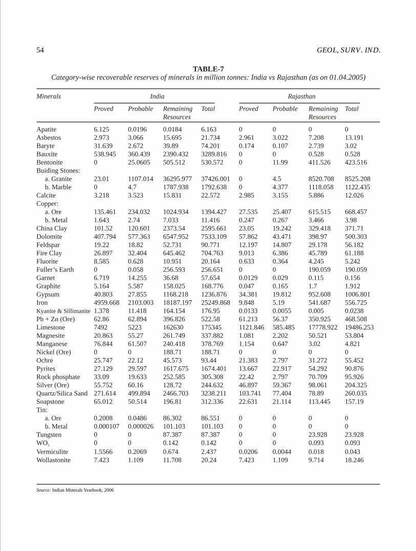
GEOL, SURV. IND.54
TABLE-7Category-wise recoverable reserves of minerals in million tonnes: India vs Rajasthan (as on 01.04.2005)
Source: Indian Minerals Yearbook, 2006
Minerals India Rajasthan
Proved Probable Remaining Total Proved Probable Remaining Total Resources Resources
Apatite 6.125 0.0196 0.0184 6.163 0 0 0 0Asbestos 2.973 3.066 15.695 21.734 2.961 3.022 7.208 13.191Baryte 31.639 2.672 39.89 74.201 0.174 0.107 2.739 3.02Bauxite 538.945 360.439 2390.432 3289.816 0 0 0.528 0.528Bentonite 0 25.0605 505.512 530.572 0 11.99 411.526 423.516Buiding Stones: a. Granite 23.01 1107.014 36295.977 37426.001 0 4.5 8520.708 8525.208 b. Marble 0 4.7 1787.938 1792.638 0 4.377 1118.058 1122.435Calcite 3.218 3.523 15.831 22.572 2.985 3.155 5.886 12.026Copper: a. Ore 135.461 234.032 1024.934 1394.427 27.535 25.407 615.515 668.457 b. Metal 1.643 2.74 7.033 11.416 0.247 0.267 3.466 3.98China Clay 101.52 120.601 2373.54 2595.661 23.05 19.242 329.418 371.71Dolomite 407.794 577.363 6547.952 7533.109 57.862 43.471 398.97 500.303Feldspar 19.22 18.82 52.731 90.771 12.197 14.807 29.178 56.182Fire Clay 26.897 32.404 645.462 704.763 9.013 6.386 45.789 61.188Fluorite 8.585 0.628 10.951 20.164 0.633 0.364 4.245 5.242Fuller’s Earth 0 0.058 256.593 256.651 0 0 190.059 190.059Garnet 6.719 14.255 36.68 57.654 0.0129 0.029 0.115 0.156Graphite 5.164 5.587 158.025 168.776 0.047 0.165 1.7 1.912Gypsum 40.803 27.855 1168.218 1236.876 34.381 19.812 952.608 1006.801Iron 4959.668 2103.003 18187.197 25249.868 9.848 5.19 541.687 556.725Kyanite & Sillimanite 1.378 11.418 164.154 176.95 0.0133 0.0055 0.005 0.0238Pb + Zn (Ore) 62.86 62.894 396.826 522.58 61.213 56.37 350.925 468.508Limestone 7492 5223 162630 175345 1121.846 585.485 17778.922 19486.253Magnesite 20.863 55.27 261.749 337.882 1.081 2.202 50.521 53.804Manganese 76.844 61.507 240.418 378.769 1.154 0.647 3.02 4.821Nickel (Ore) 0 0 188.71 188.71 0 0 0 0Ochre 25.747 22.12 45.573 93.44 21.383 2.797 31.272 55.452Pyrites 27.129 29.597 1617.675 1674.401 13.667 22.917 54.292 90.876Rock phosphate 33.09 19.633 252.585 305.308 22.42 2.797 70.709 95.926Silver (Ore) 55.752 60.16 128.72 244.632 46.897 59.367 98.061 204.325Quartz/Silica Sand 271.614 499.894 2466.703 3238.211 103.741 77.404 78.89 260.035Soapstone 65.012 50.514 196.81 312.336 22.631 21.114 113.445 157.19Tin: a. Ore 0.2008 0.0486 86.302 86.551 0 0 0 0 b. Metal 0.000107 0.000026 101.103 101.103 0 0 0 0Tungsten 0 0 87.387 87.387 0 0 23.928 23.928WO 0 0 0.142 0.142 0 0 0.093 0.0933
Vermiculite 1.5566 0.2069 0.674 2.437 0.0206 0.0044 0.018 0.043Wollastonite 7.423 1.109 11.708 20.24 7.423 1.109 9.714 18.246

MISC. PUB. No. 30 (12) 55
TABLE-8Mineral production in 2004-05 and 2005-06: India vs Rajasthan; (Value in Rs '000)
Source: Indian Minerals Yearbook, 2006
India Rajasthan
2004-05 2005-06 2004-05 2005-06
Minerals Unit Qty Value Qty Value Qty Value Qty Value
All Minerals - - 813757978 - 839386162 - 33375407 - 34210945Fuel Minerals - - 605115751 - 614847844 - - - -Natural Gas mcm 30820 89401200 31223 90407400 211 633000 238 714000Metallic Minerals - - 99403852 - 114860798 - - - -Copper Ore t 2929074 - 2642706 - 871632 - 931508 -
3Iron Ore (Total) X10 t 145942 74029029 154436 86905259 28 4839 18 1445Lead Concentrate t 81675 652733 97572 708169 81647 652698 97572 708169Silver Kg 10955 84311 27950 227870 10570 80289 24261 182808Zinc Concentrate t 666424 3998845 893287 4956091 666424 3998845 893287 4956091Non-Metallic Minerals - - 26844833 - 27283978 - - -Phosphorite t 1722983 2928350 1372951 2212353 1621020 2882893 1194013 2142227Asbestos t 6392 19022 2366 21830 5594 890 1726 300Ball Clay t 637022 117872 351049 49441 442196 63994 148547 12695Barytes t 1159031 505194 1189839 447658 3784 3526 6199 2458Calcite t 66984 21730 73332 21794 66294 21661 72892 21750Chalk t 129571 33274 146351 36992 - - - -Dolomite t 4339306 915714 4428119 1076320 108128 16351 153247 20256Feldspar t 379055 61032 322929 53329 84647 10005 63737 7443Fire Clay t 662633 90734 485755 76763 162657 26835 77760 3920Fluorite (Graded) t 6291 16360 1774 5470 1002 3029 665 2605Garnet (Abrasive) t 642329 153279 679700 195826 3 8 - -Garnet (Gem) kg 90 122 - - 90 122 - -Graphite (R.O.M) t 108150 39908 120322 43347 - - - -Gypsum t 3684758 502000 3137095 389709 3641136 478204 3104350 372698Jasper t 1265 386 580 174 1265 386 580 174Kaolin (Natural) t 933654 1091332 1096564 1341425 152699 15006 165214 17415Kyanite t 8208 6778 7341 6579 - - - -Sillimanite t 30711 115306 32278 170546 - - - -
3Limestone X10 165753 17942008 170378 19019764 25007 2971177 26666 3265553Magnesite t 383953 363971 351495 488552 342 529 - -Mica Crude t 1276 26104 1259 32248 154 1493 30 308Mica waste & Scrap t 2497 - 3384 - 476 - 518 -Ochre t 919018 56944 920600 59253 860672 50544 878956 54487Pyrophyllite t 271225 42376 181328 28958 - - - -Quartz t 319004 44349 250719 29511 53040 6686 46557 5179Quartzite t 97036 75939 107975 55273 7321 1098 7420 742Silica sand t 1962029 244699 2344793 269090 337762 51696 352610 50910Steatite t 684440 334961 627216 291057 496818 266537 441663 227231Vermiculite t 3377 5183 4774 4657 536 43 929 93Wollastonite t 170292 129097 128582 98740 170292 129097 128582 98740Laterite t 949973 90887 931297 97663 2200 57 - -
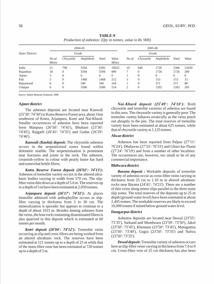
GEOL, SURV. IND.56
Ajmer district
The asbestos deposits are located near Kanwali o o(25 30': 74 30') in Kotra Reserve Forest area, about 3 km
southwest of Kotra, Arjanpura, Kotri and Nai-Khurd. Smaller occurrences of asbestos have been reported
o o oform Manpura (26 50': 74 45'), Bhubani (23 30': o o o o74 45'), Rajgarh (26 45': 74 35') and Gudas (26 29': o74 46').
Kanwali (Kaolai) deposit: The chrysotile asbestos occurs in the serpentinised zones found within dolomitic marble. The serpentinisation is prominent near fractures and joints in the rock. The asbestos, creamish-yellow in colour with pearly lustre has hard and somewhat brittle fibres.
o oKotra Reserve Forest deposit (26 02': 74 13'): Asbestos of tremolite variety occurs in the altered ultra-basic bodies varying in width from 570 cm. The slip-fibre veins thin down at a depth of 5.6 m. The reserves up to a depth of 5 m have been estimated at 2,050 tonnes.
o oArjanpura deposit (26 17': 74 32'): At places tremolite admixed with anthophyllite occurs as slip-fibre varying in thickness from 5 to 30 cm. The mineralization is sporadic but appears to continue to a depth of about 1015 m. Besides mining asbestos from the veins, the host rock containing disseminated fibres is also quarried in this deposit which is estimated at 60 tonnes per month.
o oKotri deposit (26 04': 74 12'): Tremolite veins occurring as slip and cross-fibres are being worked from an altered ultrabasic rock. The reserves have been estimated at 121 tonnes up to a depth of 25 m while that of the mass-fibre zone has been estimated at 720 tonnes up to a depth of 5 m.
o oNai-Khurd deposit (25 49': 74 10'): Both chrysotile and tremolite varieties of asbestos are found in this area. The chrysotile variety is generally poor. The tremolite variety behaves erratically as the veins pinch out abruptly in the pits. The total reserves of tremolite variety have been estimated at about 625 tonnes, while that of chrysotile variety at 1,125 tonnes.
Alwar districtoAsbestos has been reported from Palpur (27 11':
o o o76 24'), Dhalawas (27 33': 76 33') and Ghazi-ka-Thana o o(27 24': 76 19') and from a number of other localities.
The occurrences are, however, too small to be of any commercial importance.
Bhilwara district
Barana deposit : Workable deposits of tremolite variety of asbestos occur as cross-fibre veins varying in thickness from 25 cm to 1.10 m in altered ultrabasic
o orocks near Barana (24 41': 74 23'). There are a number of thin veins along minor slips parallel to the three main slip zones. The total reserves of the deposits up to 25 m depth (ground water level) have been estimated at about 2,405 tonnes. The workable reserves are likely to exceed 10,000 tonnes if mined below ground water level.
Dungarpur districtoAsbestos deposits are located near Dewal (23 55':
o o o73 35'), Sarkand and Mundwara (23 59': 73 50'), Jakol o o o o(23 50': 73 45'), Khemaru (23 50': 73 45'), Matugamra o o o o(23 50': 73 40'), Gugra (23 50': 73 35') and Nalwa o o(23 50': 73 35').
Dewal deposit: Tremolite variety of asbestos occurs here as slip-fibre veins varying in thickness from 7.6 to 9 cm. Cross-fibre vein of 25 cm thickness has also been
TABLE-9Production of asbestos: (Qty in tonnes, value in Rs '000)
Source: Indian Minerals Yearbook, 2006
2004-05 2005-06
State/ District Grade Grade
No of Chrysotile Amphibole Total Value No of Chrysotile Amphibole Total ValueMines Mines
India 21 798 5594 6392 19022 10 640 1726 2366 21830Rajasthan 18 0 5594 5594 890 7 0 1726 1726 300Ajmer 3 0 0 0 0 1 0 0 0 0Pali 3 0 1468 1468 212 3 0 153 153 15Rajsamand 6 0 540 540 164 1 0 371 371 80Udaipur 6 0 3586 3586 514 2 0 1202 1202 205
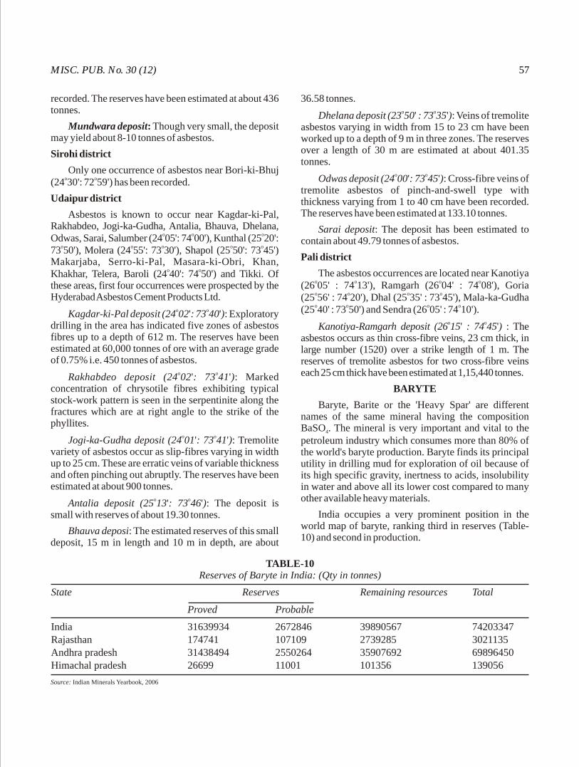
MISC. PUB. No. 30 (12) 57
recorded. The reserves have been estimated at about 436 tonnes.
Mundwara deposit: Though very small, the deposit may yield about 8-10 tonnes of asbestos.
Sirohi district
Only one occurrence of asbestos near Bori-ki-Bhuj o o(24 30': 72 59') has been recorded.
Udaipur district
Asbestos is known to occur near Kagdar-ki-Pal, Rakhabdeo, Jogi-ka-Gudha, Antalia, Bhauva, Dhelana,
o o oOdwas, Sarai, Salumber (24 05': 74 00'), Kunthal (25 20': o o o o o73 50'), Molera (24 55': 73 30'), Shapol (25 50': 73 45')
Makarjaba, Serro-ki-Pal, Masara-ki-Obri, Khan, o oKhakhar, Telera, Baroli (24 40': 74 50') and Tikki. Of
these areas, first four occurrences were prospected by the Hyderabad Asbestos Cement Products Ltd.
o oKagdar-ki-Pal deposit (24 02': 73 40'): Exploratory drilling in the area has indicated five zones of asbestos fibres up to a depth of 612 m. The reserves have been estimated at 60,000 tonnes of ore with an average grade of 0.75% i.e. 450 tonnes of asbestos.
o oRakhabdeo deposit (24 02': 73 41'): Marked concentration of chrysotile fibres exhibiting typical stock-work pattern is seen in the serpentinite along the fractures which are at right angle to the strike of the phyllites.
o oJogi-ka-Gudha deposit (24 01': 73 41'): Tremolite variety of asbestos occur as slip-fibres varying in width up to 25 cm. These are erratic veins of variable thickness and often pinching out abruptly. The reserves have been estimated at about 900 tonnes.
o oAntalia deposit (25 13': 73 46'): The deposit is small with reserves of about 19.30 tonnes.
Bhauva deposi: The estimated reserves of this small deposit, 15 m in length and 10 m in depth, are about
36.58 tonnes.o oDhelana deposit (23 50' : 73 35'): Veins of tremolite
asbestos varying in width from 15 to 23 cm have been worked up to a depth of 9 m in three zones. The reserves over a length of 30 m are estimated at about 401.35 tonnes.
o oOdwas deposit (24 00': 73 45'): Cross-fibre veins of tremolite asbestos of pinch-and-swell type with thickness varying from 1 to 40 cm have been recorded. The reserves have been estimated at 133.10 tonnes.
Sarai deposit: The deposit has been estimated to contain about 49.79 tonnes of asbestos.
Pali district
The asbestos occurrences are located near Kanotiya o o o o(26 05' : 74 13'), Ramgarh (26 04' : 74 08'), Goria o o o o(25 56' : 74 20'), Dhal (25 35' : 73 45'), Mala-ka-Gudha o o o o(25 40' : 73 50') and Sendra (26 05' : 74 10').
o oKanotiya-Ramgarh deposit (26 15' : 74 45') : The asbestos occurs as thin cross-fibre veins, 23 cm thick, in large number (1520) over a strike length of 1 m. The reserves of tremolite asbestos for two cross-fibre veins each 25 cm thick have been estimated at 1,15,440 tonnes.
BARYTE
Baryte, Barite or the 'Heavy Spar' are different names of the same mineral having the composition BaSO . The mineral is very important and vital to the 4
petroleum industry which consumes more than 80% of the world's baryte production. Baryte finds its principal utility in drilling mud for exploration of oil because of its high specific gravity, inertness to acids, insolubility in water and above all its lower cost compared to many other available heavy materials.
India occupies a very prominent position in the world map of baryte, ranking third in reserves (Table-10) and second in production.
TABLE-10Reserves of Baryte in India: (Qty in tonnes)
Source: Indian Minerals Yearbook, 2006
State Reserves Remaining resources Total
Proved Probable
India 31639934 2672846 39890567 74203347Rajasthan 174741 107109 2739285 3021135Andhra pradesh 31438494 2550264 35907692 69896450Himachal pradesh 26699 11001 101356 139056
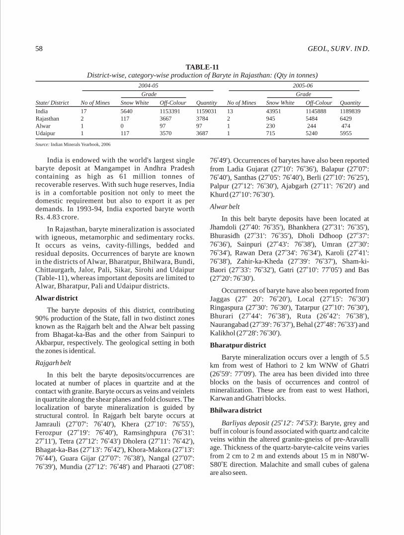
GEOL, SURV. IND.58
India is endowed with the world's largest single baryte deposit at Mangampet in Andhra Pradesh containing as high as 61 million tonnes of recoverable reserves. With such huge reserves, India is in a comfortable position not only to meet the domestic requirement but also to export it as per demands. In 1993-94, India exported baryte worth Rs. 4.83 crore.
In Rajasthan, baryte mineralization is associated with igneous, metamorphic and sedimentary rocks. It occurs as veins, cavity-fillings, bedded and residual deposits. Occurrences of baryte are known in the districts of Alwar, Bharatpur, Bhilwara, Bundi, Chittaurgarh, Jalor, Pali, Sikar, Sirohi and Udaipur (Table-11), whereas important deposits are limited to Alwar, Bharatpur, Pali and Udaipur districts.
Alwar district
The baryte deposits of this district, contributing 90% production of the State, fall in two distinct zones known as the Rajgarh belt and the Alwar belt passing from Bhagat-ka-Bas and the other from Sainpuri to Akbarpur, respectively. The geological setting in both the zones is identical.
Rajgarh belt
In this belt the baryte deposits/occurrences are located at number of places in quartzite and at the contact with granite. Baryte occurs as veins and veinlets in quartzite along the shear planes and fold closures. The localization of baryte mineralization is guided by structural control. In Rajgarh belt baryte occurs at
o o o oJamrauli (27 07': 76 40'), Khera (27 10': 76 55'), o o oFerozpur (27 19': 76 40'), Ramsinghpura (76 31':
o o o o o27 11'), Tetra (27 12': 76 43') Dholera (27 11': 76 42'), o o oBhagat-ka-Bas (27 13': 76 42'), Khora-Makora (27 13':
o o o o76 44'), Guara Gijar (27 07': 76 38'), Nangal (27 07': o o o o76 39'), Mundia (27 12': 76 48') and Pharaoti (27 08':
o76 49'). Occurrences of barytes have also been reported o o ofrom Ladia Gujarat (27 10': 76 36'), Balapur (27 07':
o o o o o76 40'), Santhas (27 05': 76 40'), Berli (27 10': 76 25'), o o o oPalpur (27 12': 76 30'), Ajabgarh (27 11': 76 20') and
o oKhurd (27 10': 76 30').
Alwar belt
In this belt baryte deposits have been located at o o o oJhamdoli (27 40: 76 35'), Bhankhera (27 31': 76 35'),
o o oBhurasidh (27 31': 76 35'), Dholi Ddhoop (27 37': o o o o76 36'), Sainpuri (27 43': 76 38'), Umran (27 30': o o o o76 34'), Rawan Dera (27 34': 76 34'), Karoli (27 41': o o o76 38'), Zahir-ka-Kheda (27 39': 76 37'), Sham-ki-
o o o oBaori (27 33': 76 32'), Gatri (27 10': 77 05') and Bas o o(27 20': 76 30').
Occurrences of baryte have also been reported from o o o oJaggas (27 20': 76 20'), Local (27 15': 76 30')
o o o oRingaspura (27 30': 76 30'), Tatarpur (27 10': 76 30'), o o o oBhurari (27 44': 76 38'), Ruta (26 42': 76 38'),
o o o oNaurangabad (27 39': 76 37'), Behal (27 48': 76 33') and o oKalikhol (27 28': 76 30').
Bharatpur district
Baryte mineralization occurs over a length of 5.5 km from west of Hathori to 2 km WNW of Ghatri
o o(26 59': 77 09'). The area has been divided into three blocks on the basis of occurrences and control of mineralization. These are from east to west Hathori, Karwan and Ghatri blocks.
Bhilwara districto oBarliyas deposit (25 12': 74 53'): Baryte, grey and
buff in colour is found associated with quartz and calcite veins within the altered granite-gneiss of pre-Aravalli age. Thickness of the quartz-baryte-calcite veins varies
ofrom 2 cm to 2 m and extends about 15 m in N80 W-oS80 E direction. Malachite and small cubes of galena
are also seen.
TABLE-11District-wise, category-wise production of Baryte in Rajasthan: (Qty in tonnes)
Source: Indian Minerals Yearbook, 2006
2004-05 2005-06
Grade Grade
State/ District No of Mines Snow White Off-Colour Quantity No of Mines Snow White Off-Colour Quantity
India 17 5640 1153391 1159031 13 43951 1145888 1189839Rajasthan 2 117 3667 3784 2 945 5484 6429Alwar 1 0 97 97 1 230 244 474Udaipur 1 117 3570 3687 1 715 5240 5955
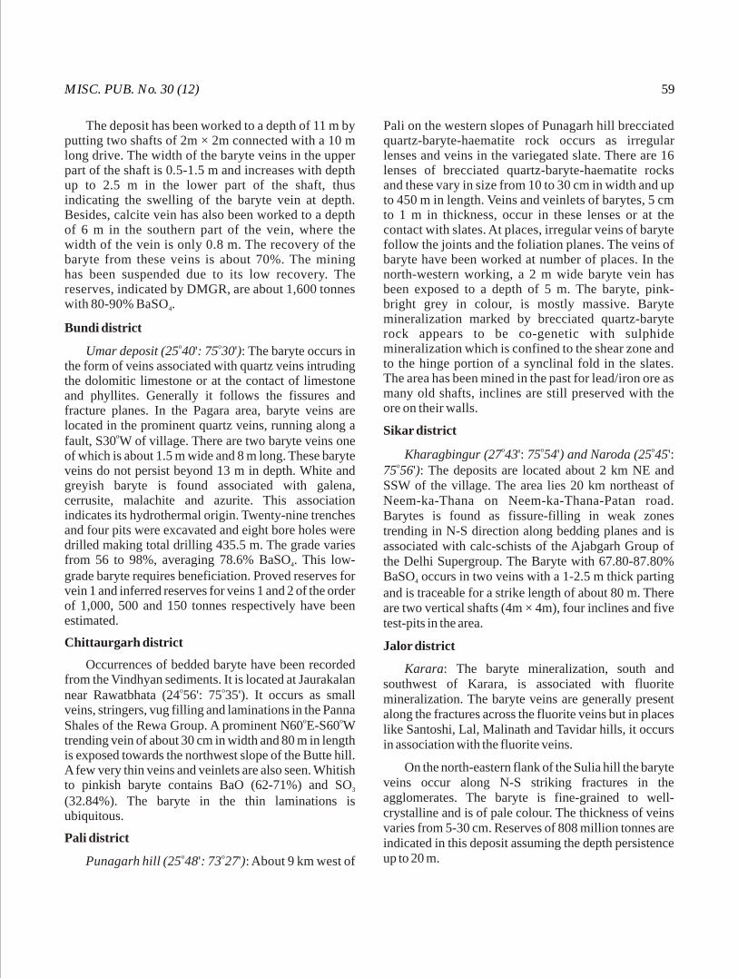
MISC. PUB. No. 30 (12) 59
The deposit has been worked to a depth of 11 m by putting two shafts of 2m × 2m connected with a 10 m long drive. The width of the baryte veins in the upper part of the shaft is 0.5-1.5 m and increases with depth up to 2.5 m in the lower part of the shaft, thus indicating the swelling of the baryte vein at depth. Besides, calcite vein has also been worked to a depth of 6 m in the southern part of the vein, where the width of the vein is only 0.8 m. The recovery of the baryte from these veins is about 70%. The mining has been suspended due to its low recovery. The reserves, indicated by DMGR, are about 1,600 tonnes with 80-90% BaSO .4
Bundi districto oUmar deposit (25 40': 75 30'): The baryte occurs in
the form of veins associated with quartz veins intruding the dolomitic limestone or at the contact of limestone and phyllites. Generally it follows the fissures and fracture planes. In the Pagara area, baryte veins are located in the prominent quartz veins, running along a
ofault, S30 W of village. There are two baryte veins one of which is about 1.5 m wide and 8 m long. These baryte veins do not persist beyond 13 m in depth. White and greyish baryte is found associated with galena, cerrusite, malachite and azurite. This association indicates its hydrothermal origin. Twenty-nine trenches and four pits were excavated and eight bore holes were drilled making total drilling 435.5 m. The grade varies from 56 to 98%, averaging 78.6% BaSO . This low-4
grade baryte requires beneficiation. Proved reserves for vein 1 and inferred reserves for veins 1 and 2 of the order of 1,000, 500 and 150 tonnes respectively have been estimated.
Chittaurgarh district
Occurrences of bedded baryte have been recorded from the Vindhyan sediments. It is located at Jaurakalan
o onear Rawatbhata (24 56': 75 35'). It occurs as small veins, stringers, vug filling and laminations in the Panna
o oShales of the Rewa Group. A prominent N60 E-S60 W trending vein of about 30 cm in width and 80 m in length is exposed towards the northwest slope of the Butte hill. A few very thin veins and veinlets are also seen. Whitish to pinkish baryte contains BaO (62-71%) and SO 3
(32.84%). The baryte in the thin laminations is ubiquitous.
Pali districto oPunagarh hill (25 48': 73 27'): About 9 km west of
Pali on the western slopes of Punagarh hill brecciated quartz-baryte-haematite rock occurs as irregular lenses and veins in the variegated slate. There are 16 lenses of brecciated quartz-baryte-haematite rocks and these vary in size from 10 to 30 cm in width and up to 450 m in length. Veins and veinlets of barytes, 5 cm to 1 m in thickness, occur in these lenses or at the contact with slates. At places, irregular veins of baryte follow the joints and the foliation planes. The veins of baryte have been worked at number of places. In the north-western working, a 2 m wide baryte vein has been exposed to a depth of 5 m. The baryte, pink-bright grey in colour, is mostly massive. Baryte mineralization marked by brecciated quartz-baryte rock appears to be co-genetic with sulphide mineralization which is confined to the shear zone and to the hinge portion of a synclinal fold in the slates. The area has been mined in the past for lead/iron ore as many old shafts, inclines are still preserved with the ore on their walls.
Sikar district
o o oKharagbingur (27 43': 75 54') and Naroda (25 45': o75 56'): The deposits are located about 2 km NE and
SSW of the village. The area lies 20 km northeast of Neem-ka-Thana on Neem-ka-Thana-Patan road. Barytes is found as fissure-filling in weak zones trending in N-S direction along bedding planes and is associated with calc-schists of the Ajabgarh Group of the Delhi Supergroup. The Baryte with 67.80-87.80% BaSO occurs in two veins with a 1-2.5 m thick parting 4
and is traceable for a strike length of about 80 m. There are two vertical shafts (4m × 4m), four inclines and five test-pits in the area.
Jalor district
Karara: The baryte mineralization, south and southwest of Karara, is associated with fluorite mineralization. The baryte veins are generally present along the fractures across the fluorite veins but in places like Santoshi, Lal, Malinath and Tavidar hills, it occurs in association with the fluorite veins.
On the north-eastern flank of the Sulia hill the baryte veins occur along N-S striking fractures in the agglomerates. The baryte is fine-grained to well-crystalline and is of pale colour. The thickness of veins varies from 5-30 cm. Reserves of 808 million tonnes are indicated in this deposit assuming the depth persistence up to 20 m.

GEOL, SURV. IND.60
The mode of occurrence of baryte in Tavidar hill area is similar to that in Sulia hill except that the E-W fractures are also mineralized here. The fractures striking N-S contain fluorite also. The vein striking E-W is devoid of fluorite and cuts across the N-S striking veins. Mineralizataion of baryte is later than that of fluorite. The thickness of veins varies from 10 cm to 35 cm. Total reserves of 3,000 million tonnes are indicated for this deposit assuming a depth persistence of 20 m for the veins.
Udaipur district
Thin streaks, lenticles, veins and bands of baryte, constituting two belts occur in association with quartz-carbonate veins within the biotite-chlorite schist, phyllite and dolomite at a number of places between
o o o oDelwara (24 45': 73 40') and Nathdwara (24 53': 73 50') oand in gneisses and schist near Relpataliya (24 24':
o73 51').
DelwaraNathdwara belt
In this belt baryte occurs mainly as fissures and breccia fillings or replacement in limestone. The mineralization is mostly confined to the chlorite schist and occurs as en echelon veins along foilation planes. The baryte deposits/occurrences of this belt are found in
o oGurli, Kioli, Junagarh (24 49' : 73 43'), Laxmi Guda o o o o(24 46' : 73 43'), Barwalia (24 48' : 73 43'), Pipalwas o o o o(24 49' : 73 44'), Nerach (24 48' : 73 42'), Khetrapal-ka-
o o o oGudah (20 48' : 73 42'), Kagmadar (24 50' : 73 43'), o o o oNagria (24 50' : 73 45'), Ramela (24 50' : 73 46'), Ghora
o o o oGhali (24 52' : 73 46'), Karowli (24 51' : 74 45'). The individual lenses however do not exceed for more than 5 m along strike. Hard, compact, and massive baryte is fine to medium-grained and milky-white to greyish-white in colour.
BAUXITE
Bauxite is used mainly for the extraction of aluminum metal, in the refractory and chemical industries, manufacture of emery powder, cement paint and in refining petroleum products. India is bestowed with large deposits of bauxite. The known bauxite reserves of the country are of the order of about 200 million tonnes, of which 140 million tonnes are of high-grade. Rajasthan, however, contributes very insignificant quantity of bauxite.
In Rajasthan bauxite occurrences near Baselio
o o o o(26 10': 77 19'), Majola (25 13': 77 23'), Mamoni o o o o(25 11': 76 06') and Sherol-Khera (25 09': 77 07') in
Kota district have been reported by the GSI. Bauxite in these areas occurs in the form of blanket capping as a product of in situ alteration of the Deccan Traps. The lengths and widths of such deposits, as revealed by surface and subsurface exploration, are 1,400 m and 450 m respectively, and the total extent is likely to be much more. The average thickness of the bauxite zones is 3 m but the maximum thickness at places is more than 15 m. Exploratory mining by the GSI has so far indicated probable reserves of 0.57 million tonnes containing on an average 49.54% Al O . The deposit was handed over 2 3
to the MECL for detailed exploration.
BENTONITE
Bentonite is one of the two naturally occurring clay minerals of montmorillonite group with decolourising and absorbing properties. Almost all bentonite assume a slightly darker shade due to absorption of moisture. Two types of bentonite viz., swelling and non-swelling type, are commonly known. Sodium-bentonite is of swelling type which swells up to 15 times while calcium-bentonite is of non-swelling type. Commercial importance of bentonite depends on its swelling index, base exchange properties and setting time. The bentonite is used as grouting material in engineering constructions, in drilling muds and as carrier in insecticides, paint and pharmaceutical industries. It is also used for bleaching vegetable oils and petroleum.
Rajasthan possesses inexhaustible reserves of both swelling and non-swelling types of bentonite. Deposits of bentonite are mostly located in Barmer and Jaisalmer districts.
Barmer districtoThe important localities are Harwecha (26 05':
o o o71 09'), Sheo (26 11': 71 15'), Hathi Singh-ki-Dhani o o o o(26 12': 71 15'), Akli (26 03': 71 13'), Thumbli o o o o o(26 03': 71 16') Giral (25 59': 71 18'), Sonri (25 59':
o o o o71 16') Bisala (25 54': 71 14'), Bhadres (25 42': o71 25') and Mahawar. A total of about 89.90 million
tonnes of bentonite of all categories are estimated from these localities. Additional reserves of 4.45 million tonnes have been proved by GSI in Bisukala area. Chemical analysis of Barmer bentonite is given in Table-12.

MISC. PUB. No. 30 (12) 61
HarwechaSheoHathi Singh-ki-Dhani areas: Bentonite beds associated with ferruginous sandstone are unconformably overlain by a conglomerate which is almost horizontal. The bentonite in most of the areas is covered by about 3050 cm of soil or loose sand. The bentonite is non-swelling type. Total probable reserves of 1.12 million tonnes have been estimated in these areas.
Akli-Thumbli-Grial: Bentonite occurrences are covered by aeolian sands in ThumbliGrial area where bentonite is associated with conglomerate and ferruginous shale. In Akli area bentonite is usually seen underlying conglomerate band which is overlain by a thick pile of sand. The bentonite beds grade from a swelling type (as seen around Akli in the northwest) to a non-swelling type or a low-swelling type (as seen in the Grial-Thumbli area towards southeast). It is chiefly composed of about 70% montmorillonite, the rest being kaolinite, attapulgite and illite. The total probable reserves have been worked out at about 55.83 million tonnes.
Sonri: A 0.6 m thick bentonite bed, unconformably overlying the Barmer sandstone (Cretaceous age), is exposed and worked. It is of high-gel and good swelling-type. The reserves are about 5.3 million tonnes.
Bisala: A 5-7 m thick bentonite bed, overlain by near-horizontal conglomerate bed containing pebble and boulders of rhyolite of the Malani Igneous Suite, is exposed in a rock cutting near Dodra Tank. It is of good swelling and high-gel type. The reserves are about 0.40 million tonnes.
Bhadres: Bentonite is associated with the Fatehgarh (Barmer) sandstone (Cretaceous) and the Kapurdi Formation (Eocene). Low-swelling, low-gel type bentonite is associated with streaks of gypsum and reddish clay in the southeast part of the deposit. The reserves are about 1.76 million tonnes.
Mahawar: Low-swelling and low-gel type bentonite beds are associated with the Barmer sandstone and the Malani volcanics. The reserves are about 0.011 million tonnes.
Devka-Rajral: The bentonite deposits occur in the the Akli Formation of Eocene age. The thickness of bentonite bed varies from 4 m to 5 m and has low-swelling index and the low-gel type has pH ranging from 7.6 to 8.4. The indicated reserves at Devka are about 9 million tonnes while at Rajral it is about 6 million tonnes. The quality of the bentonite generally compares favourably with the standard materials and may be suitable for use in oil drilling, oil refining, foundaries and as filter in paper, rubber and textile industries.
Jaisalmer district
Bentonite to sub-bentonitic clays associated with Upper Jurassic to Eocene formations occur at Khuiala, Tetakhan, Banda, Ganwarwali Talai, Khenya, Sam and at many other localities. The impersistent clay beds, varying in thickness from a few centimetre to 2.50 m, are interlayered with foraminiferal limestone or calcareous siltstone. These clays are non-swelling or poorly-swelling type and do not appear suitable for drilling muds or foundry sand. The tentative reserves of these sub-bentonitic clays from these areas are of the
TABLE-12Chemical analysis of Barmer bentonite
Source : GSI.
Hathi Singh ki-Dhani Akli Dodra Bisala Bhadres Barmer
SiO 51.4 54.9 51.4 52.4 45.232
Al O 21.4 19.4 24.7 24.1 25.482 3
Fe O & TiO 6.8 6.8 5.2 6.6 10.242 3 2
CaO 0.7 0.1 0.6 0.4 1.00MgO 1.9 – 1.5 0.4 –Na O 3.1 2.1 2.2 0.7 5.832
K O 8.7 10.9 7.4 8.1 12.222
Loss 6.0 5.8 7.0 8.3 –SiO /A1 O ratio 2.4 2.8 2.1 2.2 1.82 2 3
GEOL, SURV. IND.62
order of 6.25 million tonnes.
Besides, the sub-bentonitic clays associated with the Baisakhi shale and Bedesar calcareous claystone are also reported from Khuiala and Khudi. It is of medium-grade. Their reserves are estimated at 3 million tonnes.
BERYL
Beryl, a silicate of beryllium and aluminium, is the principal source of beryllium metal which is lighter than aluminium. When alloyed with copper and after suitable heat treatment the alloy develops high-tensile strength and ability to withstand repeated stress. Beryl has become very important in recent years because the metal is used as moderator in nuclear reactors. A small quantity of beryllium is used in the chemical industry in the manufacture of beryllium salts and in ceramic glaze. The green transparent variety of beryl is emerald which is a precious stone.
Rajasthan is the principal beryl producing State in India. Beryl occurs in association with mica pegmatites in the mica mines of Ajmer, Udaipur and Bhilwara districts.
Ajmer district
Some of the important beryl workings from o opegmatites are located near Lohagal (26 32' : 74 37') and
o oMakrera (26 15' : 74 30'). Occurrences have also been o oreported near Gujarwara (26 01' : 75 08'), Bisundani
o o o o o(25 43' : 75 10'), Barla (26 26' : 74 44'), Rajosi (26 19' : o o o o o74 39'), Kairia (26 02' : 74 54'), Tihasi (26 24' : 74 55')
o oand Dadia (26 25' : 74 59').
Udaipur district
Beryl occurrences have been recorded at Achieawas o o o o(25 20' : 73 51'), Deoru Guda (25 21' : 73 48'), Deopura o o o o(25 23' : 73 57'), Gadachat (25 18' : 73 50') and Jaolia o o(25 21' : 73 49').
Bhilwara districtoOccurrences have been recorded at Tiloi (25 17' :
o o o o74 23'), Bhunas (25 25' : 74 23'), Jhampura (25 17' : o o o74 18') and Deora (25 34' : 74 17').
BISMUTH
Bismuth is principally used in medical preparations. However, it has some other important uses for making fusible alloys in combination with tin, lead, mercury and cadmium, aluminium alloys (cerrobase alloys), production of atomic bomb, in radar equipment and in
nuclear energy projects.
Bismuth occurs in nature either in native form or as sulphide, bismuthinite Bi S . This mineral is generally 2 3
covered by thin film of the yellow oxide, bismuth ochre and is frequently associated with the ores of tin, tungsten and other base metal sulphides. Most of the bismuth metal is won as a by-product in the smelting of other ores.
In Rajasthan, a very localised and small lensoid occurrence of bismuth ore from an unzoned pegmatite at Narda, Neem-ka-Thana tahsil, Sikar district has been reported with anomalous bismuth (84.20%), arsenic (1.08%), gold (70 ppm with bismuthinite, 1.7 ppm in host rock), lead (0.17%) and copper (0.11%).
BUILDING AND ORNAMENTAL STONES
Rajasthan is famous for varieties of ornamental building and decorative stones such as marble, limestone, sandstone, granite, slate etc. The Taj Mahal, one of the wonders of the world, and the Victorial Memorial at Calcutta are made out of the white marble of Makrana area of Rajasthan, as also the famous mosques at Agra and Delhi and many buildings in Rajasthan, U.P. and Punjab. Black marble which receives good polish had been used in constructing some of the historical buildings and monuments of Delhi and Agra and is available in the mines in Jaipur district. The red and buff-coloured Bhander and Jodhpur sandstones have also yielded excellent stones for the monumental structures in Delhi, Agra and other cities of northern India. Yellow marble of Jaisalmer district is another ornamental stone used in many famous buildings of Rajasthan.
Basalt / Rhyolite
South-eastern parts of Rajasthan are partly occupied by the Deccan Traps which constitute the main building stone in this area. The rhyolite is mostly used for railway ballast and other construction purposes in western Rajasthan.
Flaggy Stone (Kotah Stone)
Upper Vindhyan limestone, quarried in Kota and Chittaurgarh districts, occurs in shades of yellow, green and blue. The quarries are located at Ramganj Mandi, Chechat, Suket, Manpura, Morak and Mur- ka-Kheri in Kota district. Flaggy limestone also occurs near Aroutiya, Paroliya and Kishanpura in the Jhalawar district.
MISC. PUB. No. 30 (12) 63
Granite
Granite and associated rocks form excellent dimensional and decorative stones. Durability, hardness, capability of taking mirror polish and fascinating colours makes the granite most distinctive stone among marble, limestone and sandstone. It is widely used as polished tiles, slabs and monumental stone all over the world.
Rajasthan has inexhaustible resources of granite, occurring within the rocks of the Precambrian age ranging from Archaean (>2,500 Ma) to Neoproterozoic (1000-570 Ma) The granites, in commercial parlance, include wide range of igneous and metamorphic rocks comprising granite, granodiorite, gneiss, enderbite-charnockite, basalt, rhyolite, dolerite, gabbro, norite etc. These rocks occur as stocks, bosses, batholiths, dykes and/or sills.
The granite occurrences in Rajasthan are distri-buted over wide areas in Ajmer, Alwar, Banswara, Barmer, Bhilwara, Chittaurgarh, Dungarpur, Jaipur, Jaisalmer, Jalor, Jhunjhunun, Jodhpur, Nagaur, Pali, Rajsamand, Sawai Madhopur, Sikar, Sirohi, Tonk and Udaipur districts. A district-wise brief account of important localities along with nature, colour and commercial names of the granite is given below:
Ajmer district
In Ajmer district the important localities are Dang, Patan, Paranga, Masuda, Jiwana, Ramgarh, Bhinai, Dantol, Chawndiya, HarmaraBuharu, Bandanwara, F a t e h g a r h , D e v p u r a , D e v m a l i , K a n p u r a , Udaigarkhera, Gujarwara, Ramaliya and Sikharani. Granite occurrences are also reported from Ana Sagar, Naikalan-Nai Khurd, Rail-ka-Barie, Daulatpura, Dedpura, Morazari, Sendra, Gordhanpura and Bandra-Sindri. The outcrops are widespread and occur as low to high ridges and rounded rocky hummock in an otherwise peneplained terrain. The commercial granites include mostly various types of gneisses and migmatites in this district. Dolerite dykes also occur, at a few places, as rocky boulders in the alluvium covered areas as in Kanpura. The gneisses and migmatites mostly pink and grey in colour exhibit banded, streaky or wavy pattern. Streaky gneisses, banded gneisses and augen gneisses are some of the important commercial granite varieties noticed in these areas which have been given different commercial names as Pink-Tiger Skin Granite, Pink-Zuberine Granite etc.
Alwar district
The granites occur around Harsora, Khatoli, Pahari, Deosan, Samda, Lialanwas, Jaisinghpur Khera and Gowara villages. Outcrops are distributed over a large area as isolated low to high mounds separated by alluvium and blown sand. Alwar Red and Alwar Grey are the commercially known varieties.
Banswara district
Occurrences of granites are reported from Narwali, Ganoda, Jupel, Mayara, MungthaliSageta, Modasel, Panthal, Piplakhunt and Thikariya villages. The granites are mostly gneisses, migmatites and amphibolites and occur as low to high ridges and boulders scattered over a small area. The colour of these commercial granites is pink and black.
Barmer district
Barmer district is very rich in good quality granites. The important occurrences are Harsani, Redana, Tribniyar, Bachabhar, Chohatan, Dhorimanna, Mangata, Meli, Ludrara, Devra, Mokalsar, Siwana, Suwala, Mungeriya, Rakhi, Phulan, Piplawa, Bachharan, Viratra, Dhok etc. In general, the granites are medium-grained and uniform in texture, and have bright colours though xenoliths of mafic rocks do occur at some places. The Barmer district has contributed to some of the famous varieties of granites viz., Mokalsar-Green, Nagina-Pink, Merrigold, Barmer-Red, Desert-Classic, Mungeriya-Amethyst, Desert-Pink etc.
Bhilwara district
The high-grade granitoids and gneisses and associated mafic rocks of Bhilwara Supergroup have given some very good varieties of dimensional stone. The important localities are Amet, Giyangarh, Nareli, Rampura, Kirimal, Katar, Boriya-ka-Buria, Phakoliya, Dhuala, Barjat, Patan, Daulatgarh, Janada, Pithas, Naugauwa (black), Udairamji-ka-Guda (black), Thane, Dhikola, Charan-ka-Bariya, Dori-Somani, Sabadare etc. Most of the granites include various types of gneisses, granodiorites, charnockites, pyroxene-granulites, enderbites and migmatites. Of this charnockite-enderbite of the Nareli-Giyangarh areas are very distinctive. These rocks occur as scattered large sized boulders, small mounds and sheets and are dark-brown to bronze-black in colour with blue opalescent quartz blebs. Cobra Black, Pink-Cobra, Black-Pearl, Black-Fantasy and Black-Panther are the known commercial varieties from this area.
GEOL, SURV. IND.64
Chittaurgarh district
The improtant localities in the district include Golia, Didiya, Gangrar, Soniana, Khuntia, Ganeshpura, Nimbahera and Chhoti Sadri. Most of these granites are the Berach Granites. A greenish-pink variety of Golie-Didiya area deserves attention.
Dungarpur district
The important granite occurrences in the district are Jallara, Ramgarh and Punawali-Bokarsal. At Jallara, the granite is pinkish-brown in colour and exhibits porphyritic texture. Overall the quality of granite is not very good.
Jaipur district
In Jaipur district granite occurrences are confined to southern part of the district. The granites are mostly granodiorite and various types of gneisses. The important localities are Sakun-Hatipura, Mal-ki-Dhani near Dudu, Mengi, Degotha, Dantri-Ladera and Bassi-ka-Bas. At Mal-ki-Dhani it is pink porphyritic granite exposed at ground level and at Bassi-ka-Bas it is highly porphyritic grey granite. In general, the outcrop density is very low. It is exposed as discontinuous low to high ridges and segregated irregular boulders in an otherwise peneplained soil covered areas. Black-Rose, Fantasia-Nero, Mid-Night Sun are some of the known commercial varieties of this area.
Jaisalmer district
Granites and rhyolites of Malani Igneous Suite and pre-Malani granites occurring at Randha, Lakha, Bhadli, Sankara, Sanwara, Khavario-ki-Dhani, Chandani, Luna etc. are considered to have commercial significance. The granites are medium to coarse-grained while rhyolites are porphyritic in nature. A wide range of beautiful colour shades of pink, purple, red, grey and off-white are available. Besides, basic dykes forming the black granites are also present in the area.
Jalor district
In Jalor district most of the area is occupied by granites and rhyolites of the Malani Igneous Suite and Erinpura Granite which occur as isolated low to high hummocks, ridges and as segregated irregular boulders with intervening soil cover and blown sand. The Jalor district has some of the very well-known granites and highly potential prospects. In general, the granites of this district are very bright in colour and are available in different shades of pink, red, orange, yellow, grey and
white. These are mostly equigranular having uniform texture. Porphyritic varieties also occur at some places. The important localities are Sanphar, Pizopura, Keshwana, Kalaghatta, Kalkaji, Tarwa, Deru, Mur, Leta Dhawla, Bhatela, Maylawas, Sakarna, Bicchawari, Khambi, Nosra, Bagra, Nann, Korana Kot, Tabab, Sangaliya Jodha, Sangaliya Sindlan, Bibalsar, Ranwara, Talwara, Kaston, Dhola, Bala, Borta etc. JalorPink, Sindoor-Red, China-Pink, Anglo-Grey, Ash-Grey, Rosy-Pink, Jalor-Red, Rani-Yellow, Imperial-Pink and Royal-Touch are some of the well-known varieties in the granite market.
Jhunjhunun district
The important localities in Jhunjhunun district are Nand, Lal Pahari, Rizani-Rasoda-Nand-Bakara, Makhar, Karpura, Hukampura, Guda, Bagora, Banglawas, Dosi, Bibasar, Kherpura, Bassi, Gumansar, Gogaji-ka-Pahar, Khetri etc. Here the granite is mostly porphyritic and is associated with rhyolites and occur as bouldery hillocks and mounds. The granite is mostly pink and grey in colour. The well-known commercial varieties of these are Steel-Grey, Jhunjhunun-Red and Grey and Makhar-Red.
Jodhpur district
Isolated outcrops of Erinpura Granite and Malani rhyolites form small hillocks or occur as ground level exposures. The important granite localities include Desuriya, Bishunaya, Jasai, Bisala, Taralana, Nangris, Jodha-Mali, Ransigaon, Khari yona, Ramaniyana, Madlia, Pipar, Khejaralo etc.
Nagaur district
The granite occurs near Morad and Kinsariya village. It is mostly pink in colour and exposed as segregated boulders in an otherwise soil covered areas.
Pali district
In Pali district off-white, bluish-grey, pink, orange and red varieties of granites mostly belonging to the Erinpura Granite are exposed as sheets and mounds, hillocks and scattered boulders. The granite, medium to coarse-grained in general, is of gneissic variety. Porphyritic varieties also occur at a few places. The important localities are Chotila, Kerla, Khardo-ki-Dhani, Kaliwara, JakhodaMetra, Chilai, Bar, Sendra (Jhala-ki-Chowki), ManihariBala, Paldi Sumerpur, Erinpura, Nana-Beda, Saithur, Rani Nadol-Narai-Veerpura, Kota, Samariya, Kherda, Kerale, Kothar,
MISC. PUB. No. 30 (12) 65
Javaria, Netra, Jhakh, Khindra, DaniDantiwara, Ranchalwara, Satpalia, Sadri, Desuri etc. China-Blue, Silver-Grey and Imperial-Pink, Lovely-Orange and Tomato-Red are some of the well-known established varieties of this area.
Rajsamand district
Pink granite gneisses of Lasoni, Sonora-ka-Bariya and Kalaon-ki-Anty; brownish-black, pinkish-black, varieties of Kakrod, Isarmand and Malkot and white variety of Amet are important granites and their localities in Rajsamand district. The granite forms mostly bouldery country over a peneplained terrain.
Sawai Madhopur district
The important granite localities are Bauli, Baragaon, Sarwar, Khajana Dunger, Nagal Pahar and Karwaripal. Most of the granites are gneissic granites.
Sikar district
In Sikar district granite occurrences are reported from Dabla, Jeetala, Kharbipura, Ajitgarh, Jatpura, SeoliGowarian, Siroli, Saladipura, Chapoli, and Bagora. The granite occurs as high hillocks and isolated bouldary outcrops. Most of the granite is earthy to pinkish to grey in colour with red garnet spots. The granites of Sikar district in general are not of very good quality. Ajitgarh-Grey and Ajitgarh-White are famous varieties.
Sirohi district
Erinpura Granites are spread over a large part of the district and occur in the form of isolated outcrops, low lying hummocks and ground level exposures. These are mostly biotite-bearing greyish-white granites. At some places pinkish and red varieties belonging to Jalor Granite of Malani Igneous Suite are also exposed. The important localities are Sanpur, Mirpur, Jeerawal, Sivera, Viroli, Nandia, Birwara, Idarla-Karja, TawriJaila, Jivana, Sankara, Rampura, Van, Padiv, Kesarpura, Telpura, Abu, Veerwade-Arasanaji, Mermundwara, Koleshwara, PadruKhera, Shivganj, Anapura, Jhar, Amlari etc. Platinum-White variety is well-known in commercial market.
Tonk district
The granites, granodiorites, granitic gneisses, migmatite and associated mafic rocks of the Bhilwara Supergroup occupy most of the area in Tonk district. These rocks occur as sheets, scattered boulders, small mounds and hillocks. The important localities are
Deval, Ganwar, Rajpura, Lamba, Malare, Kadila, Hata-ki-Bagri-Rupawati, Phulmaliya, Hisampura, Malpura, Govardhanpura etc. The granitic gneisses, granites and migmatites are mostly pink to grey in colour with alternate bands of light and dark coloured minerals. Deval-Multi-colour and GreyTiger Skin are some well-known varieties from this area.
Udaipur district
The important granite occurrences in Udaipur district include Gingla, Untala, Udaisagar, Udaipur (Ahar river), Dakan Kotra, Jaisamand, Salumber, Jhalara, SairaPadrada, Kagwas, Moanda, Modi-Bathera-Kanor, Bari Sadri etc. In general, the granites of Udaipur district are not suitable for dimensional stone purposes. However, Akola-Khurd-Gyaspur area in Bari Sadri and Makreda Magra of Udaipur granite deserve attention.
Marble
In Rajasthan, marble and marble based industries are very well developed. The marble and marble products are used in house construction, statues, marble chips, marble/dolomite powder and plaster making; as tyre detergent; and in gur, sugar, and paper industries.
The marble is won from the Precambrians of Rajasthan mainly from rocks of the Delhi Supergroup. However, marble is also reported from the rocks of B.G.C. and pre-Aravallis at places. Marble is mainly mined from Makrana, Rajnagar, Rikhabdev, Ajmer, Andhi and Bhaislana areas. Abur limestone and Jaisalmer limestone take good polish and are used as decorative stones. These are marked as 'Suparistone' and 'Yellow-marble' respectively.
Morwar in Rajsamand district has a single mine (out of numerous mines) which produces 300,000 metric tonnes of blocks-slabs of white marble per year creating a world record which find a place in the Guinness Book of World Records.
The enormity of the Morwar mines can be gauged 2by the fact that it has a spread of about 71,000 m . Sky-
Line, Silver-Line, Emerald-Line, Green-Line, Grey-Line etc. are commercial names given to the other special varieties of marble products of the area. Production of blocks and slabs increased to 0.30 and
20.436 million m respectively during 1996-97.
Rajasthan possesses the largest reserves exceeding 1,100 million tonnes accounting for about 95% of the total production of marble in India. The chief deposits of marble are as follows:

GEOL, SURV. IND.66
Nagaur district
At Makrana, the marble is fine-grained crystalline and calcareous in nature containing more than 98% CaCO . Chemically it has higher contents of silica, 3
alumina and magnesia as compared to that of marble from Italy and Greece. Thus it has more abrasive resistance and is easy to process. Being fine-grained and comparatively free of impurities, it takes good polish and has great demand in market.
Jaipur district
At Bhainsalana the marble is fine-grained, dark, greyish-black, hard, compact, massive while the marble at Raisala and Andhi is dolomitic in nature, off-white and fine-grained. The Pista-marble of Andhi has comparatively better aesthetic value due to presence of uniformly scattered greenish minerals.
Ajmer district
Sursuri, Narawar, Tokra, Kishangarh, Umaria, Kharwa, Daulatpur, Baktawarpura, Shyopura, Bijapur, Sardhana, Kyampura, Magra etc. are the important localities of marble occurrences in the district.
Udaipur district
The marble of the Rajnagar-Agsia-Amet belt of Udaipur district is white to off-white in colour and contains comparatively more MgO content, as a result of which it turns yellowish after sometime. Similar marble deposits occur at Mandaria, Maharaj-ki-Khedi, Hairo etc. At Babarmal, pink, fine-grained, hard and compact marble occurs. It contains comparatively high silica. At Keshariaji (Rikhabdev), Prasad and Kalyanpura green serpentinite is mined and marketed as green marble.
Sirohi district
Ghoratankri, Perwa-Serwa, Murthala, Ajari, Bhala, Bhatan, Selwara, Deri, Indli, Badechi and Khandra are important localities of marble deposits. At Selwara, the large blocks of medium to coarse- grained marble could easily be excavated.
Banswara district
The marble occurring in this district is dolomitic, mostly fine-grained, white, light golden-yellowish, pink and green in colour. The important localities include Vithaldev, Tripura Sundri, Khema-Talai, Bhanwaria-Talai (white), Bhim-Kund, Oda-Bassi, Chinch (pink) etc.
Bundi district
Marble occurring at Bundi is commercially marketed as Umar marble. It is fine-grained, greyish to white with shades of green and pink. The marble is dolomitic in nature.
Bhilwara district
The marble occurring in this district is black, dark, green and greyish white in colour. Important localities include Manohargarh (Jahajpur), Boleta, Goga-ki-Khera etc. The marble is dolomitic in nature.
Dungarpur district
In this district fine to medium-grained, off-white, pink and green marble deposits are located. Important localities include Rohanwada, Mal-Surata, Antri-Peeth (green), Sabla, Nandli, Dad (pink) etc.
Sikar, Pali and Chittaurgarh districts
Maonda is an important locality for marble in Sikar district, while Bar and Sendra; and Mandaleh in Pali and Chittaurgarh districts respectively are known for marble occurrences.
Alwar district
In this district dolomitic marble deposits occur at Jhiri, Rajgarh, Kho, Sarer and Gordhanpur.
Jaisalmer district
Calcilutite and calcarenite varieties of fine-grained golden yellow limestone occurring near Moolsagar.
Amarsagar, Jethwai, Pithala, Chundi, Manpra, Bhagata etc. are commercially being exploited and marketed as yellow marble.
Sandstone
Sandstone is mainly found in the Vindhyan and the Marwar Supergroup sequences of Bharatpur, Tonk, Sawai Madhopur, Bundi, Chittaurgarh districts and Jodhpur, Bikaner, Pali, Jaisalmer districts respectively. Rajasthan has been the main centre of export of sandstone to other parts of the country. The important occurrences of sandstone are found in Bharatpur (Bansi-
o o oPaharpur 27 00' : 77 10'), Bikaner (Dumera 28 24' : o o73 35'), Bundi (Umarthuna), Jaipur (Kotri 27 30' : o75 35', Juger and Radhonathgarh), Jodhpur (near
o oJodhpur city, Sojat 25 55' : 73 40' and Khatu), Kota (Mokundwara, Kanawas), Tonk (Amli), Sawai
o oMadhopur (Karauli 26 25' : 76 55', Hindaun) districts.
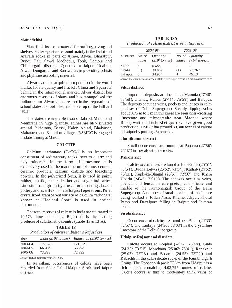
MISC. PUB. No. 30 (12) 67
Slate / Schist
Slate finds its use as material for roofing, paving and shelves. Slate deposits are found mainly in the Delhi and Aravalli rocks in parts of Ajmer, Alwar, Bharatpur, Bundi, Pali, Sawai Madhopur, Tonk, Udaipur and Chittaurgarh districts. Quarries in Jaipur, Udaipur, Alwar, Dungarpur and Banswara are providing schists and phyllities as roofing material.
Alwar slate has acquired a reputation in the world market for its quality and has left China and Spain far behind in the international market. Alwar district has enormous reserves of slates and has monopolised the Indian export. Alwar slates are used in the preparation of school slates, as roof tiles, and table top of the Billiard table.
The slates are available around Bahrod, Maton and Neemrana in huge quantity. Mines are also situated around Jakharana, Bassai, Kalor, Adind, Bhaiyasar, Mahatavas and Khundrot villages. RSMDC is engaged in slate mining at Maton.
CALCITE
Calcium carbonate (CaCO ) is an important 3
constituent of sedimentary rocks, next to quartz and clay minerals. In the form of limestone it is extensively used in the manufacture of lime, cement, ceramic products, calcium carbide and bleaching powder. In the pulverized form, it is used in paint, rubber, textile, paper, leather and sugar industries. Limestone of high-purity is used for imparting glaze in pottery and as a flux in metallurgical operations. Pure, crystallized, transparent variety of calcium carbonate, known as “Iceland Spar” is used in optical instruments.
The total reserves of calcite in India are estimated at 10,573 thousand tonnes. Rajasthan is the leading producer of calcite in the country (Table-13 & 13-A).
In Rajasthan, occurrences of calcite have been recorded from Sikar, Pali, Udaipur, Sirohi and Jaipur districts.
Sikar districtoImportant deposits are located at Maonda (27 48':
o o o75 58'), Jhamas, Raipur (27 44': 75 58') and Balupur. The deposits occur as veins, pockets and lenses in calc-gneisses of Delhi Supergroup. Steeply dipping veins about 0.75 m to 1 m in thickness are seen criss-crossing limestone and microgranite near Maonda where Bhikajiwali and Bada Khet quarries have given good production. DMGR has proved 39,300 tonnes of calcite at Raipur by putting 25 trenches.
Jhunjhunun districtoSmall occurrences are found near Paparna (27 56':
o75 47') in the calc-silicate rocks.
Pali districtoCalcite occurrences are found at Bara Guda (25 51':
o o o o73 54'), Budha Lelwa (25 52': 73 54'), Kalhab (24 52': o o o73 11'), Kapli-ka-Bhagal (25 57': 72 58') and Khera
o oUparla (24 45': 73 10'). The deposits occur as veins, pockets and lenses in calc-gneiss, calc-silicate and marble of the Kumbhalgarh Group of the Delhi Supergroup. A number of small pockets of calcite are being worked at Pitlan Nana, Khemel Alipur, Khoral Patan and Dayalpura falling in Raipur and Jaitaran tehsils.
Sirohi districtoOccurrences of calcite are found near Bhula (24 33':
o o o72 57'), and Tankiya (24 50': 73 03') in the crystalline limestone of the Delhi Supergroup.
Udaipur-Rajsamand districtso oCalcite occurs at Goiphal (24 47': 73 48'), Guda
o o o o(24 35': 73 51'), Morchana (25 06': 73 41'), Ranakpur o o o o(25 07': 73 28') and Sadarla (24 55': 73 22') and
Rabachh in the calc-silicate rocks of the Kumbhalgarh Group. The Rabachh deposit 73 km from Udaipur is a rich deposit containing 4,03,795 tonnes of calcite. Calcite occurs as thin to moderately thick veins of
TABLE-13Production of calcite in India vs Rajasthan
Source: Indian minerals yearbook, 2006.
TABLE-13AProduction of calcite district wise in Rajasthan
Source: Indian minerals yearbook, 2006; figure in parenthesis indicates associated mine
Year India (x103 tonnes) Rajasthan (x103 tonnes)
2003-04 122.329 121.3292004-05 66.984 66.2942005-06 73.332 72.892
2004-05 2005-06
Districts No. of Quantity No. of Quantity3 3mines (x10 tonnes) mines (x10 tonnes)
Sikar 3 0.488 - -Sirohi (1) 30.852 (1) 23.762Udaipur 6 34.954 4 49.13

GEOL, SURV. IND.68
variable length in zones of decomposed limestone. Other deposits are known to occur at Siyawa, Kheterla, Binsa Singh, Sanwara and many other places. Good deposit of calcite is located in Khila and Khera about 35 km northeast of Pindwara. Calcite occurs as oval to crescent-shaped capping over the wollastonite hill. Snow-white to white, off-brown and pale-white in colour, the calcite is invariably associated with skarn, cavities filled with mud and decomposed limestone patches. The DMGR has proved 8,78,330 tonnes of calcite at Khila and 8,618 tonnes towards at Khera where six pockets of white to off-white crystalline calcite occurs close to quartz and/or pegmatite veins.
CHINA CLAY
Extensive deposits of china clay are found in India. With the increasing demand from industries like ceramic, refractory, textile, paper, rubber and pesticides, the production of the mineral has increased to a very large extent. Almost the entire production of china clay is consumed indigenously. A small quantity of superfine variety is also imported for specialized uses.
Rajasthan contributes about 50% production of china clay, 40% of ball clay and 10% of fire clay in the country. China clay is found to occur in Bhilwara, Bundi, Chittaurgarh, Jaipur, Jhalawar, Sawai Madhopur, Sikar, Pali districts etc. Ball clay occurs in Alwar, Bikaner and Bundi districts. Chemical analysis of important clay deposits of Rajasthan is given in Table-14.
Bikaner district
Clay deposits have been reported from Mudh o o o o o(27 52' : 72 54'), Chandi (24 53' : 73 00'), Kotri (27 50' :
o o o72 59') and Palana (27 51' : 73 18').
Mudh : The clay is greyish-white in colour and free from grit. It is fine-grained and consists mainly of kaolinite. The clay has good plasticity, the water of plasticity being 27.6%. It fires to cream colour. Colour of the clay is not improved by washing. The estimated reserves are about 302 million tonnnes.
Chandi : The clay deposit is found near the surface, overlain by 1 m thick bed of kankar. The thickness of the deposit varies from 0.12 m to 20 m. The clay has a good degree of plasticity, the water of plasticity being 27.6%. It fires to cream colour. The estimated reserves are about 3.05 million tonnes.
Kotri-Marh-Gura area : The extensive clay odeposits around Kotri, Marh and Gura (27 50'20" :
o72 57'30") area form a continuous horizon for about 15 km in strike length and extend beyond Gura. There are at least three clay horizons within the Palaeocene rocks. The middle clay horizon is the richest one having at least five separate clay bands alternating with ferruginous sandstone, grit and white siltstone. The individual clay beds are 13 m in thickness. The lower horizon contains two clay bands of 1.52.5 m thickness, while the upper horizon has only one bed which varies in thickness from 3 to 7 m. The clay devoid of grit is white, creamy or
TABLE-14Chemical analysis of important clay deposits in Rajasthan
Source : GSI.
(District) Bikaner Nagaur Sawai Madhopur Sikar Bhilwara Sikar(Village) Marh Gura Khajwana Raesena Basu Torda Mangrop BacharaKotri
SiO 59.8 1 56.90 57.02 61.41 40.28 46.28 45.86 47.1763.582
Al O 26.16 24.17 27.73 23.36 34.44 38.50 37.42 33.63 25.832 3
Fe O 1.10 2.50 < 1 1.76 0.30 0.13 1.31 1.17 0.962 3
TiO 2.91 0.63 1.73 – 1.66 1.58 0.12 2.50 –2
CaO Trace Trace – 2.43 0.25 0.18 1.12 0.12 –MgO Trace 0.90 < 1 1.70 0.36 – 0.15 0.92 –K O 0.98 – – – – – – 3.06 –2
Na O 0.51 – – – – – – 0.24 –2
(KNa) O – 2.90 < 1 – 0.14 0.46 0.35 – –2
LOI 8.56 6.00 10.64 7.46 12.37 12.18 13.6 10.65 9.63P.C.E. 1,380°F

MISC. PUB. No. 30 (12) 69
brownish-white, often interlayered with impure clays, sometimes with ferruginous stains. It is highly plastic and fine-grained, and composed mainly of kaolinite. The water of plasticity is about 27.6%.
The reserves of clay are expected to be about 43.67 million tonnes. The clay is being used in ceremic industry and as filter in paper and textile industries.
Barmer districto oClay deposits occur in Bolia (25 59' : 71 22'),
o o o oBhadras (25 83' : 71 19'), Gunga (26 48' : 73 30') o o o oNagurda (26 10' : 71 23') Nimla (26 03' : 71 20') and
o oSonri (25 59' : 71 10').
Bolia : The clay occurs in six beds, interstratified with sandstone, varying in thickness from 0.75 m to 3 m. Based on an average total thickness of 7.6 m, 1,01,000 tonnes of reserves have been estimated for the deposit. The water of plasticity (25.1%) and vitrification
otemperature (1,450 C) make the clay suitable for pottery earthenware, paper and rubber industries.
Gunga : A creamish-white plastic clay bed of about o2.4 m thickness is present. The clay vitrifies at 1,320 C
and is suitable for low-grade pottery. Similar type of clay also occurs at Nimla, Bhopa etc.
Bundi district
A two-metre thick kaolin band occurs along a ridge o osouth of Manak Chowk (25 33': 75 54'). The reserves
were estimated approximately 1,01,600 tonnes. This clay is white in colour which on firing changes to cream and grey colour. Other parameters are water of plasticity (23.428.4%), air shrinkage (2.392.87%) and moderate vitrification.
Pali district
Greyish-white clay with an average thickness of 2 m occurs in Literia. Upper part of the deposit is slightly iron stained. It possesses a fair degree of plasticity (25.01%). The estimated reserves of the deposit are about 2.53 million tonnes.
Nagaur districto oKhajwana (26 55': 73 53'): A 1.5 m thick non-
plastic clay bed within the Nagaur sandstone is exposed in a quarry. It is reported to be useful in earthenware paper and rubber industries.
Clay pockets are also reported to occur at Kuladah, Indawar, Mundwa, Nimri, Chandawatan, Saradana and Haldah.
Sawai Madhopur districtoClay has been reported from Raesena (26 41':
o o o o76 36'), Basu (26 06': 76 36') and Phalodi (20 51': o76 26').
Raesena: The clay is whitish in colour and has fairly good plasticity. It fires to white colour. The reserves estimated are about 3.05 million tonnes.
Basu: The clay associated with feldspathic quart-zite is white in colour and free from grit. The reserves estimated of the deposit are about 1.12 million tonnes.
Phalodi: The 1.52.4 m thick clay located in Phalodi, is plastic, slightly gritty, white to pale-yellow in colour.
oit vitrifies fairly at 1,450 C and fires to pale-grey with dark spots. The reserves estimated vary between 20,300 tonnes to 38,600 tonnes. Other clay occurrences are at
o o o oNaurali (26 16': 76 53') and Talwara (26 20': 76 38').
Sikar districtoThe clay deposits are found near Buchara (27 30' :
o o o o75 55'), Torda (27 26' : 76 01'), Fatehpura (27 34' : o o o o76 03'), Khelna (27 32' : 75 09'), Sonpura (27 30' : o o o o76 03'), Gol (26 37' : 76 23') and Purshotampur (27 43' : o75 52').
Buchara : The clay bed, about 5 m thick, derived from the kaolinised feldspar of pegmatite is located east of Buchara. The reserves estimated are about 1,12,000 tonnes. The clay is generally white in colour, fairly plastic, the water of plasticity being 33.32%. The chemical analysis of the clay is : SiO 63.58%, Al O 2 2 3
25.83%, Fe O 0.96% and L.O.I. 9.63%. Blended with 2 3
high-grade clay, this clay can be used in the manu-facture of stoneware, chinaware etc.
Torda : The average thickness of the clay band at Torda is about 5 m and the reserves estimated for the deposit are about 60,000 tonnes. The clay is white with occasional limonitic stains. The water of plasticity is 33.44% and sp.gravity is 2.5.
Alwar districto oClay is reported near Rajgarh (27 09' : 76 35'),
o o o oPhargoli (27 09'30" : 76 49'), Mudali (27 19' : 76 38') o oand Kalgaon (27 42'30" : 76 46'). It is greyish-white in
colour and slightly iron stained. The clay is moderately plastic with the water of plasticity 15.99%.
Bhilwara district
o oClay deposit occurs near Mangrop (25 40': 74 40').
- -- -
GEOL, SURV. IND.70
The average thickness of the deposit is 2.5 m. The clay, soft and white in colour, is very plastic and fires to cream colour. The estimated reserves are about 1.01 million tonnes.
Chittaurgarh district
Good clay deposits are reported to occur near Eral o o o o(24 31': 74 40') and Sawa (24 45': 74 30').
Eral: Clay is greyish-white in colour, very fine-grained and fairly plastic. The estimated reserves of the deposit are about 6.1 million tonnes.
Sawa : The Sawa clay is generally greyish-white in colour and fires to buff colour. It is moderately plastic, the water of plasticity being 18.04%.
Udaipur district
The clay deposit is located about 7 km ESE of o oUdaipur near Kharbaria-ka-Gurha (24 33': 73 43'). The
thickness of the clay band is likely to exceed 17 m. The inferred reserves of this deposit are about 3.99 million tonnes. The clay is fairly plastic, the water of plasticity varying between 31.24% and 44.70%. It is non-fusible
owhen fired to 1,400 C and has a low-dry shrinkage.
Jaisalmer district
Pockets and bands of clay interstratified with the Lathi sandstone occur at Chhor, Keta and Duskot and within the Mandai sandstone at Mandai. The clay bands are 12 m in thickness. The clays have low-shrinkage and have restricted use in pottery as they develop cracks on firing.
Jodhpur district
Clay bands ranging in thickness from 3 m to 6 m occur on the Masuria hill near Jodhpur. Low-grade variety occurs at Kharadia within limestone of the Bilara Group.
COLUMBITE TANTALITE(Niobium - Tantalum)
Columbite and tantalite, the niobates and tantalates of iron and manganese, are the most important ores of niobium and tantalum. The nearly-pure niobate is called columbite and the nearly-pure tantalate is tantalite.
Ajmer district
Columbite and tantalite are reported to occur in pegmatites at Ugai mine, Lohagal and Makerwali,
o oDazipura and Nimrikhera (25 59' : 74 10').
Udaipur districto oAt Lakola (25 10' : 74 18') large irregular crystals
weighing up to 15 lbs. containing over 30% Ta O and 2 5
45% Nb O are reported to occur in pegmatites.2 5
Chittaurgarh distirct
Columbite-tantalite mineral is reported to occur at Soniana where coarse-grained mineral is associated with veins of quartz and aplite with 35% Ta O and over 2 5
41% Nb O .2 5
Bhilwara district
The columbite-tantalite ores containing about 15% Ta O and 60% Nb O are reported to occur at Sangua. 2 5 2 5
The presence of columbite and tantalite has also been recorded from the pegmatite bodies at Danta mines,
o oLaxmi mines and Bhunas (25 13' : 74 23').
COPPER
Copper is the most essential metal used by the man since the 'Bronze age'. Inspite of its part substitution by aluminium, the demand of copper is ever increasing. At present the production of copper metal in the country is only 15,000 tonnes as against the annual demand of about 0.5 million tonnes. A major part of the demand for this metal is, therefore, met by imports causing heavy drain on our foreign exchange.
Substantial reserves of copper ore have been established in Rajasthan, which now hold a significant place in the country in this important base metal resource. The main occurrences of copper ore are located along the prominent mineralizsed belts viz., Khetri Copper Belt and Alwar Copper Belt in the northeast part of the State. Besides, a number of small copper deposits associated with other base metal occurrences, which are under various stages of exploration, have been brought to light in other parts of the State.
Jhunjhunu district
Khetri Copper Belt
The Khetri Copper Belt extends over a strike length of about 80 km from Singhana in the north to Raghunathgarh in the south. The important deposits are
o olocated at Madhan Kudhan (28 05' : 75 48'), Kolihan o o o o o(28 02' : 75 47'), Akwali (27 56' : 75 48'), Satkui (27 49'
o o o: 75 33') and Dhanota (27 45' : 75 36'). In addition a number of branching and parallel zones have also been
o ofound along the belt at Deoru (28 03' : 75 48'), Banwas o o o o(28 05' : 75 48'), Dholamala (27 59' : 75 48'), Rajotha
-
MISC. PUB. No. 30 (12) 71
o o o o o(28 01' : 75 49'), Usri (27 49' : 75 48'), Ajitsagar (28 03' : o o o o75 52'), Taonda (27 58' : 75 53'), Malwali (27 57' : o o o75 50'), Chinchorli (27 50' : 75 45'), Bokri, Naori
o o o o o(27 50' : 75 38'), Ponk (27 48' : 75 38'), Goria (27 45' : o75 51') and other places.
Madhan-Kudhan deposit : The deposit is situated towards the northern extremity of the Khetri Copper Belt and is 30 km by road from Nizampur railway station on Rewari Reengus section of the Western Railway. The Cu mineralization in this area is found in the Ajabgarh and the Alwar Groups of rocks belonging to the Delhi Supergroup. The principal host rocks for mineralization are the garnetiferous chlorite-quartz-amphibole schist and quartzite. The Cu mineralization is mainly in the form of irregular net-work of impersistent stringers, disseminations, blebs and patches of metallic sulphides, mostly chalcopyrite, pyrrhotite and pyrite. Pyrrhotite is about three times as abundant as chalcopyrite. Pyrite is present in negligible quantity or may represent 5 10% of the total sulphides.
This deposit was investigated and proved by GSI/IBM during the period from March, 1957 to November, 1964. The block was handed over to the Hindustan Copper Ltd. (HCL) in 1964 for exploitation. However, further drilling in this area is being continued by the GSI/MECL on behalf of HCL in the extention areas. The total drill-indicated reserves are of the order of 92.8 million tonnes comprising 46.2 million tonnes of proved category and 46.6 million tonnes of probable category having an average grade of 1.0% Cu. The underground exploratation by HCL for detailed proving has indicated so far 43.92 million tonnes of proved category of 0.91% Cu at 0.5% cutoff, most of which is localised in the Central Block.
Kolihan deposit : The Kolihan deposit is situated 6.5 km to the south of the Madhan Kudhan deposit and 3 km from Khetri. The Kolihan deposit has been divided into seven blocks viz., South Block, South-Central Block, Central Block, North-Central Block, North Block, Kalapahar Block and Intervening Block. The Central Block constituting the main Kolihan deposit and the South Block, called Chandmari deposit, have been proved and recommended for production by the GSI. The distinct lodes were delineated in the Central Block (main Kolihan deposit) with copper content up to 2.5% in the mineralized lodes. Small amount of Ni, As and Ag are also found. The reserves estimated in this block are of the order of 24.43 million tonnes of ore containing an average grade of 1.4% Cu. In the South Block (Chandmari deposit), reserves of 3.50 million tonnes of
-
-
-
copper ore with an average grade of 0.88% Cu have been established by the GSI. Drilling in the North Block has indicated reserves of about 1.34 million tonnes of ore containing 1% Cu.
Akwali deposit: Akwali deposit lies in the middle of the Khetri Copper Belt and is about 6 km south of Khetri. Cu mineralization has been traced by GSI during 1962 1970 over a strike length of 1,000 m in Akwali North Block of which about 700 m is more promising. The estimated reserves are about 1.65 million tonnes of ore containing an average grade of 1.5% Cu. Some of the copper ores from Akwali area also contain rich pockets of Cu mineralization.
Satkui deposit: The deposit is situated at about 20 km east of Neem-ka-Thana railway station. The minearlized zone at Satkui constitutes a part of GoriaSatkui Dhanota section of the Khetri Copper Belt. A number of old workings and shafts spread over a strike length of 700 m are present in the western flank of the Satkui hill. Besides these, mine debris and slag dumps lie scattered over the sand dunes near the old workings. The mineralized zones are found to be localized along a major strike-slip fault developed at the contact of the massive hard quartzite and soft phyllitic quartzite of the Ajabgarh Group. Copper mineralization has been traced over a strike length of 1,000 m. The drill-indicated reserves are of the order of 3.88 million tonnes of ore containing an average grade of 1.19% Cu at 0.5% cutoff.
o oBanwas (28 05': 75 48'): The deposit is situated north of Madankeda deposit. The area is largely under a cover of alluvium except in the southeastern part where lenticular bands of marble occur in the chlorite schist. The sulphides comprising pyrrhotite, chalcopyrite and pyrite occur as fine disseminations, stringers and veinlets along bedding, foliations and fractures in siliceous dolomite, schist and in footwall quartzite. The reserves estimated over 800 m strike length in the area are of the order of 2.64 million tonnes of ore containing an average grade of 1.9% Cu.
o oDholamala (27 59': 75 48'): This deposit occurs as a parallel zone about 1.5 km to the east of Khetri Copper Belt. The sulphide mineralization is mainly of massive and disseminated type. Mineralization is restricted to the sheared and silicified zone occurring at the contact of garnetiferous chlorite schist and amphibolite. The ore reserves estimated by the MECL are of the order of 1.5 million tonnes of 0.91% Cu.
Other smaller deposits of copper ore along the belt, where the ore has been proved to some extent are mainly
-
--
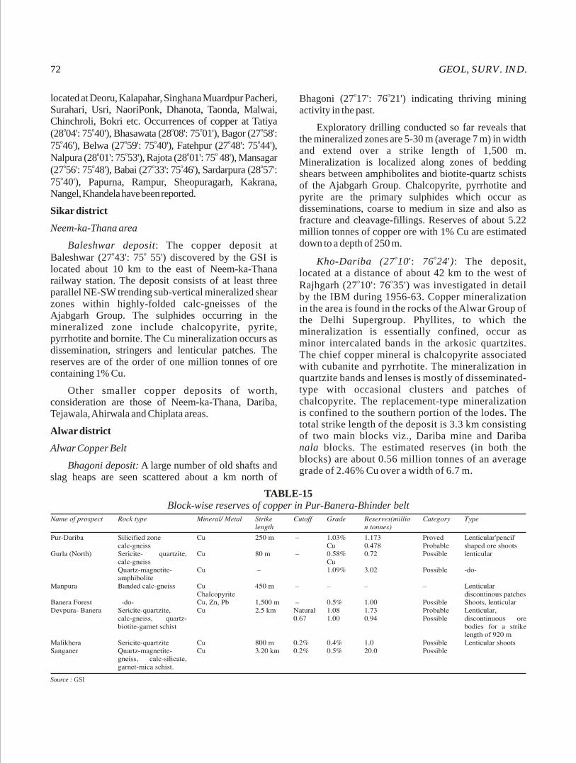
GEOL, SURV. IND.72
located at Deoru, Kalapahar, Singhana Muardpur Pacheri, Surahari, Usri, NaoriPonk, Dhanota, Taonda, Malwai, Chinchroli, Bokri etc. Occurrences of copper at Tatiya
o o o o o(28 04': 75 40'), Bhasawata (28 08': 75 01'), Bagor (27 58': o o o o o75 46'), Belwa (27 59': 75 40'), Fatehpur (27 48': 75 44'),
o o o oNalpura (28 01': 75 53'), Rajota (28 01': 75 48'), Mansagar o o o o o(27 56': 75 48'), Babai (27 33': 75 46'), Sardarpura (28 57':
o75 40'), Papurna, Rampur, Sheopuragarh, Kakrana, Nangel, Khandela have been reported.
Sikar district
Neem-ka-Thana area
Baleshwar deposit: The copper deposit at o oBaleshwar (27 43': 75 55') discovered by the GSI is
located about 10 km to the east of Neem-ka-Thana railway station. The deposit consists of at least three parallel NE-SW trending sub-vertical mineralized shear zones within highly-folded calc-gneisses of the Ajabgarh Group. The sulphides occurring in the mineralized zone include chalcopyrite, pyrite, pyrrhotite and bornite. The Cu mineralization occurs as dissemination, stringers and lenticular patches. The reserves are of the order of one million tonnes of ore containing 1% Cu.
Other smaller copper deposits of worth, consideration are those of Neem-ka-Thana, Dariba, Tejawala, Ahirwala and Chiplata areas.
Alwar district
Alwar Copper Belt
Bhagoni deposit: A large number of old shafts and slag heaps are seen scattered about a km north of
o oBhagoni (27 17': 76 21') indicating thriving mining activity in the past.
Exploratory drilling conducted so far reveals that the mineralized zones are 5-30 m (average 7 m) in width and extend over a strike length of 1,500 m. Mineralization is localized along zones of bedding shears between amphibolites and biotite-quartz schists of the Ajabgarh Group. Chalcopyrite, pyrrhotite and pyrite are the primary sulphides which occur as disseminations, coarse to medium in size and also as fracture and cleavage-fillings. Reserves of about 5.22 million tonnes of copper ore with 1% Cu are estimated down to a depth of 250 m.
o oKho-Dariba (27 10': 76 24'): The deposit, located at a distance of about 42 km to the west of
o oRajhgarh (27 10': 76 35') was investigated in detail by the IBM during 1956-63. Copper mineralization in the area is found in the rocks of the Alwar Group of the Delhi Supergroup. Phyllites, to which the mineralization is essentially confined, occur as minor intercalated bands in the arkosic quartzites. The chief copper mineral is chalcopyrite associated with cubanite and pyrrhotite. The mineralization in quartzite bands and lenses is mostly of disseminated-type with occasional clusters and patches of chalcopyrite. The replacement-type mineralization is confined to the southern portion of the lodes. The total strike length of the deposit is 3.3 km consisting of two main blocks viz., Dariba mine and Dariba nala blocks. The estimated reserves (in both the blocks) are about 0.56 million tonnes of an average grade of 2.46% Cu over a width of 6.7 m.
TABLE-15Block-wise reserves of copper in Pur-Banera-Bhinder belt
Source : GSI

MISC. PUB. No. 30 (12) 73
Other smaller deposits of copper in Alwar and
Jaipur districts, where copper ore with average grade of o0.5% have been reported, are at Baldeogarh (27 08':
o o o o76 23'), Kalighati (27 19': 76 25'), Nalladeshwar (27 o o o25': 76 27'), Kalajoda (27 26': 76 11'), Pratapgarh
o o o o(27 15': 76 09'), Matasula (27 09': 76 05'), Gol-o o o oBadshapur (27 16': 76 05'), Dhanta (27 13': 76 04'),
o oTodi-ka-Bas and Achrol (27 08': 75 59'). Copper ooccurrences have also been reported from Agar (27 19':
o o o o o76 12'), Deota (27 49': 76 45'), Tatarpur (27 45': 76 35'), o o o oPiplai (27 13': 76 15'), Angari (27 21': 76 35'), Sainpuri
o o o o(27 44': 76 38'), Baraud (27 54': 76 23'), Jodhwas o o(27 20': 76 18'), Dhaula and Khan Khera.
Bhilwara district
Pur-Banera-Bhinder belt: The Pur-Banera belt o o o o(25 18': 74 33' to 25 30': 74 41') extends over a length of
34 km having a width of about 5 km. The belt is
subdivided into a prominently Pb-Zn rich eastern zone
and a Cu-rich western zone in which the mineralization
is associated with quartz-biotite-muscovite-garnet
schist, quartz-amphibole-magnetite gneiss, sericite
quartzite and calc-gneiss.
Old workings, gossans and slag heaps indicating
favourable locales for Cu, Pb and Zn mineralization are
scattered over a strike length of 25 km. This area has
been under exploration by the GSI from time to time.
Copper deposits/occurrences of significance are
located at Pur-Dariba, Gurla, Manpura, Banera forest,
DevpuraBanera, Malikhera, Sanganer, Rajpura,
Dhulikhera and Gadan-ka-Khera (Table- 15).
Devpura-Banera block : The main rock types are
calc-gneiss with magnetite-rich bands, sericite quartzite
and quartz-biotite-muscovite-garnet schist. The rocks o o o o otrend N50 -70 E - S50 -70 W dipping 45 due SE. Cu
mineralization is mainly found in sericite quartzite and
its contact with calc-gneiss. The mineralized zone is
traced over a strike length of about 2.5 km (the main
concentration being confined to one km length) with a
width of 25-140 m. The main sulphide minerals are
chalcopyrite and pyrite with minor cubanite, covellite
and bornite. In total, 16 lodes have been delineated
within the mineralized zone. The main load extends
over a strike length of 920 m with a width of 1-6.5 m
containing 0.8% copper.
Kaladhunda-Lakhola-Surawas belt
The Kaladhunda-Lakhola-Surawas belt has been
considered as the northeastern extension of Bethumbi-
Rajpura-Dariba synform. It is a narrow belt over 25 km
long and 1 to 1.75 km wide extending from Kaladhunda
in the northeast to Surawas in the southwest. The
Bethumbi-Dariba-Rajpura belt occurs in south-western
extension of this belt.
Evidences of base metal mineralization in the belt
are seen in occasional development of gossans, profuse
development of malachite stains particularly in calc-
silicate rocks and the presence of a few old workings.
The rock types exposed in the belt are medium-grade
garnetiferous mica schist, quartzite, quartz schist,
amphibolite, calc-silicate rock often interbanded with
dolomite and marble, marble with lenses of calc-silicate
rock and carbon phyllite.
Geochemical bedrock sampling of the belt indicates
higher concentration of Cu in amphibole and calc-
silicate rocks while zinc shows preferential enrichment
in marble and carbon phyllite. A strong Cu anomaly
zone, extending over 2,000 m strike length, is located
between Kaladhunda and Satdudhia. Another 1,000 m
long Pb and Zn anomaly zone, near Bharak, partly
coincides with high-Cu zones.
o oIn Satdudhia (24 14' : 74 17') area which is the
north-eastern continutaion of Rajpura-Dariba belt, two
ore bodies of 500 m and 100 m strike length, having
more than 1.5% Cu have been delineated within a 1,400
m long mineralized zone. Mineralization is stratabound
within garnet and staurolite bearing mica schist close to
its contact with calc-silicate rock. Total reserves of 0.95
million tonnes of ore with 1.34% Cu have been
estimated.
Chittaurgarh district
Small copper deposits of importance are also
established in Wari-Akola-Bhinder segment i.e., the
southern half of the Rajpura-Dariba-Bhinder Belt.

GEOL, SURV. IND.74
Wari-Akola-Bhinder segment
In the Wari Akola Bhinder segment carbonaceous
sch is t , soda- rhyol i te , garne t -mica sch is t ,
staurolite/kyanite schist, amphibolite and quartzite are
tightly folded into isoclinal folds with fold axes
trending NS. The host rocks for Cu mineralization are
metasoda- rhyolite, garnet-mica schist and quartz
amphibolite. Mainly copper mineralization has been
encountered in this segment. Chalcopyrite, pyrite and
pyrrhotite are the main ore minerals occurring as
disseminations, stringers and veins. Mineralization is
often fault/shear controlled. A list of the blocks in
which reserves have been estimated is given in Table-
16.
o oWari (24 53': 74 32'): This deposit is located a km
west of Wari and 5 km south-southeast of Dariba-
Rajpura Pb-Zn deposit. The ground is mostly covered
with scanty exposures. Garnetiferous mica schist and
amphibolite with bands of calc-silicate rock are the
main rock types which are intruded by quartz vein and
dolerite. Cu mineralization occurs in lenticular bands
showing pinch-and-swelling structures in the
amphibolite-rich rock. The sulphides are chalcopyrite,
pyrite and pyrrhotite. Reserves of about 1.89 million
tonnes of 1.07% Cu have been estimated.
Sirohi district
Pipela-Ajari area: Evidences of Cu mineralization o oat Pipela (24 38': 72 56') about 30 km north-northeast of
o o o oDeri (24 23': 72 50') and Ajari (24 48': 73 03') have been
reported. The mineralized zone varies in width from
0.20 m to 12 m with 0.52.74% Cu and 0.50.72% Zn in
Pipela while at Ajari the zone varies in width from 0.5 m
to 12 m with 0.241.89% Cu and 0.573.32% Zn. The
geological set-up is similar to Basantgarh and Golia
deposits. The rocks belong to the Kumbhalgarh Group
of the Delhi Supergroup.
Deri area: The DMGR has proved Cu minerali-
zation in association with Pb-Zn mineralization near o oDeri (24 23': 72 50'). The presence of six parallel bands
of mineralization over a total strike length of one km has
been proved. The estimation of reserves indicates the
presence of more than one million tonnes of ores
containing Cu (1.87%), Zn (7.32%) and Pb (5.49%). In
the East Block a 3 m wide zone with Cu (0.98%), Zn
(12.01%) and Pb (2.64%) has also been intersected
while drilling.
Golia: The DMGR has also proved Cu o omineralization with zinc near Golia (24 41': 72 58').
Exploratory work in this area indicated reserves of
about one million tonnes containing 0.8% Cu.
Basantgarh: This deposit, located at a distance of 10
km from Sirohi-Road railway station, lies in the Deri
belt. The rock formations are limestone, garnetiferous
chlorite-biotite schist, calc-gneiss, amphibolite and
quartzite belonging to the Kumbhalgarh Group of the
Delhi Supergroup. A prominent gossan zone is exposed
in the calcareous formation on the western bank of
Dharwet rivulet.
TABLE-16Block-wise reserves of copper in Wari-Akola-Bhinder segment of the Pur-Banera belt
Source : GSI
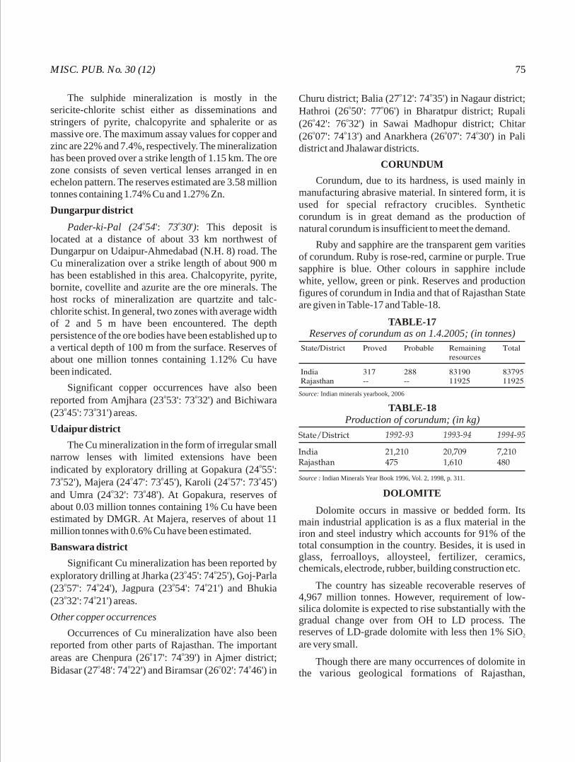
MISC. PUB. No. 30 (12) 75
The sulphide mineralization is mostly in the sericite-chlorite schist either as disseminations and stringers of pyrite, chalcopyrite and sphalerite or as massive ore. The maximum assay values for copper and zinc are 22% and 7.4%, respectively. The mineralization has been proved over a strike length of 1.15 km. The ore zone consists of seven vertical lenses arranged in en echelon pattern. The reserves estimated are 3.58 million tonnes containing 1.74% Cu and 1.27% Zn.
Dungarpur districto oPader-ki-Pal (24 54': 73 30'): This deposit is
located at a distance of about 33 km northwest of Dungarpur on Udaipur-Ahmedabad (N.H. 8) road. The Cu mineralization over a strike length of about 900 m has been established in this area. Chalcopyrite, pyrite, bornite, covellite and azurite are the ore minerals. The host rocks of mineralization are quartzite and talc-chlorite schist. In general, two zones with average width of 2 and 5 m have been encountered. The depth persistence of the ore bodies have been established up to a vertical depth of 100 m from the surface. Reserves of about one million tonnes containing 1.12% Cu have been indicated.
Significant copper occurrences have also been o oreported from Amjhara (23 53': 73 32') and Bichiwara
o o(23 45': 73 31') areas.
Udaipur district
The Cu mineralization in the form of irregular small narrow lenses with limited extensions have been
oindicated by exploratory drilling at Gopakura (24 55': o o o o o73 52'), Majera (24 47': 73 45'), Karoli (24 57': 73 45')
o oand Umra (24 32': 73 48'). At Gopakura, reserves of about 0.03 million tonnes containing 1% Cu have been estimated by DMGR. At Majera, reserves of about 11 million tonnes with 0.6% Cu have been estimated.
Banswara district
Significant Cu mineralization has been reported by o oexploratory drilling at Jharka (23 45': 74 25'), Goj-Parla
o o o o(23 57': 74 24'), Jagpura (23 54': 74 21') and Bhukia o o(23 32': 74 21') areas.
Other copper occurrences
Occurrences of Cu mineralization have also been reported from other parts of Rajasthan. The important
o oareas are Chenpura (26 17': 74 39') in Ajmer district; o o o oBidasar (27 48': 74 22') and Biramsar (26 02': 74 46') in
o oChuru district; Balia (27 12': 74 35') in Nagaur district; o oHathroi (26 50': 77 06') in Bharatpur district; Rupali
o o(26 42': 76 32') in Sawai Madhopur district; Chitar o o o o(26 07': 74 13') and Anarkhera (26 07': 74 30') in Pali
district and Jhalawar districts.
CORUNDUM
Corundum, due to its hardness, is used mainly in manufacturing abrasive material. In sintered form, it is used for special refractory crucibles. Synthetic corundum is in great demand as the production of natural corundum is insufficient to meet the demand.
Ruby and sapphire are the transparent gem varities of corundum. Ruby is rose-red, carmine or purple. True sapphire is blue. Other colours in sapphire include white, yellow, green or pink. Reserves and production figures of corundum in India and that of Rajasthan State are given in Table-17 and Table-18.
TABLE-17Reserves of corundum as on 1.4.2005; (in tonnes)
Source: Indian minerals yearbook, 2006
TABLE-18Production of corundum; (in kg)
Source : Indian Minerals Year Book 1996, Vol. 2, 1998, p. 311.
DOLOMITE
Dolomite occurs in massive or bedded form. Its main industrial application is as a flux material in the iron and steel industry which accounts for 91% of the total consumption in the country. Besides, it is used in glass, ferroalloys, alloysteel, fertilizer, ceramics, chemicals, electrode, rubber, building construction etc.
The country has sizeable recoverable reserves of 4,967 million tonnes. However, requirement of low-silica dolomite is expected to rise substantially with the gradual change over from OH to LD process. The reserves of LD-grade dolomite with less then 1% SiO 2
are very small.
Though there are many occurrences of dolomite in the various geological formations of Rajasthan,
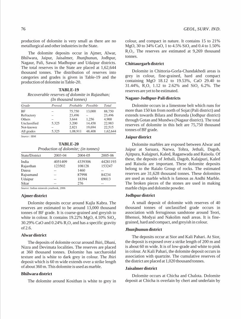
GEOL, SURV. IND.76
production of dolomite is very small as there are no metallurgical and other industries in the State.
The dolomite deposits occur in Ajmer, Alwar, Bhilwara, Jaipur, Jaisalmer, Jhunjhunun, Jodhpur, Nagaur, Pali, Sawai Madhopur and Udaipur districts. The total reserves in the State are placed at 1,62,644 thousand tonnes. The distribution of reserves into categories and grades is given in Table-19 and the production of dolomite in Table-20.
colour, and compact in nature. It contains 15 to 21% MgO, 30 to 34% CaO, 1 to 4.5% SiO and 0.4 to 1.50% 2
R O . The reserves are estimated at 9,269 thousand 2 3
tonnes.
Chittaurgarh district
Dolomite in Chittoria-Gorla-Chandakhedi areas is grey in colour, fine-grained, hard and compact containing MgO 18.12 to 19.53%, CaO 29.40 to 31.44%, R O 1.12 to 2.62% and SiO 6.2%. The 2 3 2
reserves are yet to be estimated.
Nagaur-Jodhpur-Pali districts
Dolomite occurs in a limestone belt which runs for more than 150 km from north of Sojat (Pali district) and extends towards Bilara and Borunda (Jodhpur district) through Gotan and Mundwa (Nagaur district). The total reserves of dolomite in this belt are 75,750 thousand tonnes of BF grade.
Jaipur district
Dolomite marbles are exposed between Alwar and Jaipur at Saruara, Narwa, Tohra, Jethali, Dagob, Ajitpura, Kalajpuri, Kaled, Raganwada and Raisola. Of these, the deposits of Jethali, Dagob, Kalajpuri, Kaled and Raisola are important. These dolomite deposits belong to the Raialo Group of rocks. The estimated reserves are 31,628 thousand tonnes. These dolomites are used as marble which is famous as Andhi Marble. The broken pieces of the stones are used in making marble chips and dolomite powder.
Jodhpur district
A small deposit of dolomite with reserves of 40 thousand tonnes of unclassified grade occurs in association with ferruginous sandstone around Teori, Bhensoi, Modyai and Nakolim nadi areas. It is fine-grained, hard and compact, and greyish in colour.
Jhunjhunun district
The deposits occur at Sior and Kali Pahari. At Sior, the deposit is exposed over a strike length of 200 m and is about 60 m wide. It is of low-grade and white to pink in colour. At Kali Pahari, the dolomite deposit occurs in association with quartzite. The cumulative reserves of the district are placed at 1,020 thousand tonnes.
Jaisalmer district
Dolomite occurs at Chicha and Chalota. Dolomite deposit at Chicha is overlain by chert and underlain by
TABLE-19Recoverable reserves of dolomite in Rajasthan;
(In thousand tonnes)
Source : IBM
TABLE-20Production of dolomite; (in tonnes)
Source: Indian minerals yearbook, 2006
Ajmer district
Dolomite deposits occur around Kajla Kabra. The reserves are estimated to be around 13,000 thousand tonnes of BF grade. It is coarse-grained and greyish to white in colour. It contains 19.22% MgO, 4.10% SiO , 2
30.29% CaO and 0.24% R O and has a specific gravity 2 3
of 2.6.
Alwar district
The deposits of dolomite occur around Jhiri, Dhani, Nizra and Devimata localities. The reserves are placed at 360 thousand tonnes. Dolomite has saccharoidal texture and is white to dark grey in colour. The Jhiri deposit which is 60 m wide extends over a strike length of about 360 m. This dolomite is used as marble.
Bhilwara district
The dolomite around Kosithan is white to grey in

MISC. PUB. No. 30 (12) 77
buff-coloured crystalline dolomite. It is white, soft and fine-grained. The reserves in the district are estimated at 3,150 thousand tonnes.
Sikar district
Dolomite deposits occur around Makri, Machwa, Maonda and Kali Dungri. The reserves in the district are 1,951 thousand tonnes.
Makri area: The dolomite is white in colour, thick-bedded, crystalline and massive in nature and occurs in association with bands of calc-gneisses. In Machwa area, dolomite occurs in association with calc-gneisses.
Maonda area: Hard and compact dolomite of SMS and low-grade analyses CaO 31.23%, MgO 21.14%, SiO 3.92%, Fe O 0.38%, Al O 0.12% and LOI 2 2 3 2 3
42.25%.
Sawai Madhopur district
The reserves of dolomite in the district are 23,500 thousand tonnes.
Udaipur district
Siliceous dolomitic limestone white in colour and saccharoidal in nature containing 2-5% SiO and 18-2
20% MgO occurs extensively in the district. The reserves in the district have been estimated around 2,550 thousand tonnes.
FELDSPAR
Feldspar is an alumino-silicate mineral of potassium, sodium and/or calcium. Though feldspar is among the most widely distributed rock-forming minerals and occurs as a constituent of most of the rocks, its commercial deposits are mainly confined to pegmatites. Feldspar is either quarried from the
pegmatite veins or is recovered as by-product to the mining of mica and beryl from the pegmatites. Feldspar is chiefly used in the ceramic and glass industries and in insulator making. Rajasthan is the principal feldspar producing State in the country and its reserves are about 10.13 million tonnes which constitute 72% of the total Indian reserves. Out of the total reserves of the State 2,30,827 tonnes are in proved category, 2,74,949 tonnes in probable category and the remaining 9.6 million tonnes in possible category. Out of these reserves 1.63 million tonnes are of pottery ceramic grade and rest of unclassified grade.
Rajasthan contributed 59% of the total production of feldspar in the country during the period from 2004 to 2006 (Table-21).
In Rajasthan, feldspar occurrences have been reported from Ajmer, Alwar, Jaipur, Pali and Sikar districts.
Alwar district
The reserves of the district are placed at 9.50 million tonnes. Out of these 1.52 million tonnes are of pottery grade, 7.96 million tonnes are of unclassified grade and 18,225 tonnes fall under not-known category. The prominent deposits are located around Mindani Tilana Sokalia; Jalia Pithawas Dhuni Kala-Khera Thuni thakiJawaja; Chawandiya; Sindari-Sandolia; Dantli Deranthu Dhal Loharwara Gangapur; Samod Usmadhal; Kabri; Dabrelia Piproli Mundot.
Ajmer district
Pink variety of feldspar is reported from Tatarpur o o(27 45': 76 35') and Khairthal. At present feldspar is
mined at Tatarpur and the total reserves in the possible category are 44,603 tonnes.
TABLE-21Production of feldspar; (Qty. in tones; value in Rs '000)
Source: Indian minerals yearbook, 2006; figures in parentheses indicate number of associated mines.
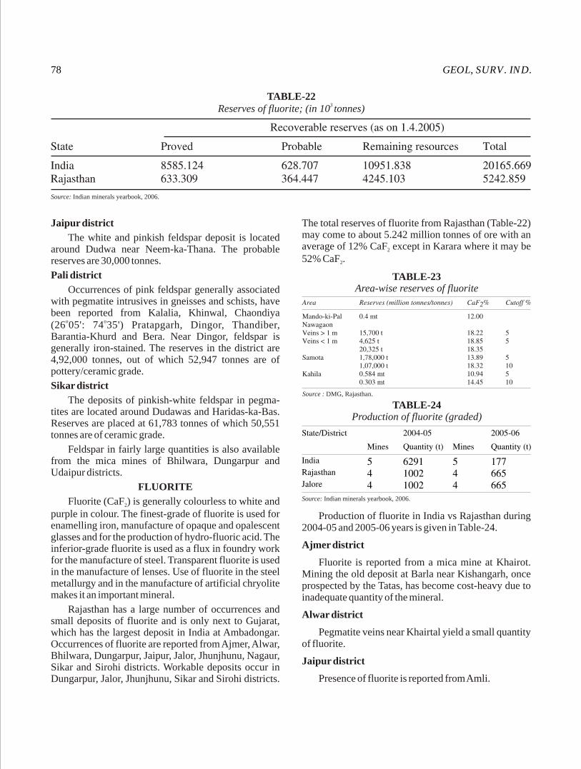
GEOL, SURV. IND.78
Jaipur district
The white and pinkish feldspar deposit is located around Dudwa near Neem-ka-Thana. The probable reserves are 30,000 tonnes.
Pali district
Occurrences of pink feldspar generally associated with pegmatite intrusives in gneisses and schists, have been reported from Kalalia, Khinwal, Chaondiya
o o(26 05': 74 35') Pratapgarh, Dingor, Thandiber, Barantia-Khurd and Bera. Near Dingor, feldspar is generally iron-stained. The reserves in the district are 4,92,000 tonnes, out of which 52,947 tonnes are of pottery/ceramic grade.
Sikar district
The deposits of pinkish-white feldspar in pegma-tites are located around Dudawas and Haridas-ka-Bas. Reserves are placed at 61,783 tonnes of which 50,551 tonnes are of ceramic grade.
Feldspar in fairly large quantities is also available from the mica mines of Bhilwara, Dungarpur and Udaipur districts.
FLUORITE
Fluorite (CaF ) is generally colourless to white and 2
purple in colour. The finest-grade of fluorite is used for enamelling iron, manufacture of opaque and opalescent glasses and for the production of hydro-fluoric acid. The inferior-grade fluorite is used as a flux in foundry work for the manufacture of steel. Transparent fluorite is used in the manufacture of lenses. Use of fluorite in the steel metallurgy and in the manufacture of artificial chryolite makes it an important mineral.
Rajasthan has a large number of occurrences and small deposits of fluorite and is only next to Gujarat, which has the largest deposit in India at Ambadongar. Occurrences of fluorite are reported from Ajmer, Alwar, Bhilwara, Dungarpur, Jaipur, Jalor, Jhunjhunu, Nagaur, Sikar and Sirohi districts. Workable deposits occur in Dungarpur, Jalor, Jhunjhunu, Sikar and Sirohi districts.
TABLE-223 Reserves of fluorite; (in 10 tonnes)
Source: Indian minerals yearbook, 2006.
TABLE-23Area-wise reserves of fluorite
Source : DMG, Rajasthan.
TABLE-24Production of fluorite (graded)
Source: Indian minerals yearbook, 2006.
Production of fluorite in India vs Rajasthan during 2004-05 and 2005-06 years is given in Table-24.
Ajmer district
Fluorite is reported from a mica mine at Khairot. Mining the old deposit at Barla near Kishangarh, once prospected by the Tatas, has become cost-heavy due to inadequate quantity of the mineral.
Alwar district
Pegmatite veins near Khairtal yield a small quantity of fluorite.
Jaipur district
Presence of fluorite is reported from Amli.
The total reserves of fluorite from Rajasthan (Table-22) may come to about 5.242 million tonnes of ore with an average of 12% CaF except in Karara where it may be 2
52% CaF .2
MISC. PUB. No. 30 (12) 79
Bhilwara district
Occurrences of fluorite are reported from Udaipur o o o o(25 44' : 74 16'), Bara Khera (25 43' : 74 19'), Baretpura o o o o(25 41' : 74 17') and Dantra (23 42' : 74 17'). Fluorite
occurs as stringers and impersistent veins, 1-5 cm in width, along joints and fractures in biotite gneiss. The mineral is translucent and violet in colour.
Dungarpur district
The fluorite mineralization is associated with the rocks of Mangalwar Complex of the Bhilwara Super-group which has been intruded by granites and pegmatites. The mineralization is controlled by structure. The ore bodies, lenticular in shape, consist of coarse fluorite with calcite, quartz and chert.
Mando-ki-Pal-Kahila belto oMando-ki-Pal (23 47': 73 52') - Kahila: The deposits
extending from Hathai in the north to Kahila in the south, covering a distance of 15 km to 20 km are by far the largest in Rajasthan. The northern half of the belt covers the deposits of Hathai, Nawagaon, Matatiba and Samota where stringers and veins of fluorite occur as fracture fillings in the granites or in the rafts of metasediments found within the gneiss. At Bhowria-ka-Naka and Kahila which form the southern part of the belt, the fluorite veins occur along bedding planes or fractures in the Aravalli quartzites and quartz-mica schists.
In the Hathai-Nawagaon-Matatiba areas, the veins run NNE-SSW or NE-SW, whereas in the Samota area, they run in WNW to ESE direction. In Bhowria-ka-Naka area, the veins follow and occupy a NNW-SSE trending fault zone running parallel to the strike of the country rocks. In the Kahila area, the veins strike NW-SE at the NNW end of the block and have WNW-ESE trend in the central Kahila block, veering almost to EW at the eastern extremity of the vein. Area wise reserves are given in Table-23.
Jalor district
Karara (Karda): The fluorite mineralization, confined to the joints, is found in the volcanic agglomerate, trachyte and basalt assemblage. The grade is very good compared to that of Dungarpur. The reserves are placed at 0.17 million tonnes with 52% CaF .2
Jhunjhunu district
Chokri Chapoli: Fluorspar veins are found in feldspathic quartzite, and the reserves are 1.13 million tonnes with 12% CaF . 2
Nagaur district
A specimen of fluorite was found at Rewat hill near Degana railway station having presence of tungsten, bismuth and uranium, the later two probably forming uranosphaerite.
Sikar district
Veins of fluorite occur as fracture-fillings at o oSalwarai (27 40': 75 37') and reserves of 0.35 million
tonnes with 12% CaF have been estimated. 2
Sirohi district
Good-grade fluorite has been recently located by GSI at Balda where veins and pockets of fluorite occur as fracture and cavity-fillings in the brecciated and silicified zones and quartz veins. The mineralization is associated with the late volatile-rich magmatic phase of the Erinpura Granite. Four fluorite-bearing veins/zones ranging in length from 25 m to 350 m with widths ranging from 0.50 m to 40 m have been delineated in the area. The best vein is 150 m long and 2 m wide. The fluorite is grey to violet in colour with more than 90% CaF . Reserves are tentatively 2
estimated at 50,000 tonnes. Fluorite minerlization occurs with or without wolframite. However, when wolframite is present it is very sparse and sporadic in the fluorite zones.
FULLER'S EARTH
Fuller's earth, also known as Multani Mitti is clay of sedimentary origin composed essentially of attapulgite, montmorillonite and kaolinite. It is used as cosmetic and for cleaning woolen clothes. It has absorbent properties which enable it to remove greasy and oily matter. It is also used in refining oils and animal fats.
Major production of fuller's earth in India comes from Rajasthan. Annual production is about 5,000-6,000 tonnes. Barmer is the main producing district contributing about 77% of total production of the State. The rest of the production comes from Bikaner (18%) and Jaisalmer (5%) districts. With the increase in the output of mineral oil and vegetable oil products in India, a progressive increase in demand for fuller's earth is apprehended.
Barmer district
The important deposits of fuller's earth are found o o onear Kapurdi (25 54': 71 22') and Alamsaria (25 42':
o71 27'). Other occurrences are near Joranda, Sheo, Rodhi and Bharka. At Bharka, a 3 m thick fuller's earth bed is being worked at about 15 m depth.
GEOL, SURV. IND.80
Bikaner districto oFuller's earth occurs at Palana (27 51': 73 92'),
o o oKesardasar (27 50': 73 25') and Marh (27 52': o73 53'). At Marh, it occurs in two beds which are 14
m and 1 m thick. Reserves estimated by GSI are 4.33 million tonnes of high-grade and 2.77 million tonnes of low-grade, besides inferred reserves of about 12 million tonnes. In Palana area, 1.8-2.4 m thick beds of fuller's earth occur above lignite horizon. The estimated reserves are of the order of 13 million tonnes.
Jaisalmer districto oFuller's earth occurs at Manda (27 20': 70 50') and
o oMandai (26 22': 71 08'). At Manda, fuller's earth is exposed with a thickness ranging from 0.60-2.75 m and has reserves of about 30,000 tonnes. Fuller's earth is also reported from Dholi-ki-Dungri, Khumsar, Pangli, Khuiala and Bandha.
Nagaur district
Fuller's earth, about 10 m thick, associated with ferruginous grits, gritty feldspathic sandstone, black shale and lignite has been located by GSI in a well section north of Igair. Good quality fuller's earth exposed in well sections near Arisar, Deswal and Chhappri occurs as small pockets and lenses and it is generally mixed with angular quartz grains.
GEMSTONES
Since time immemorial gemstones, because of their unique characterstics such as colour, transparency, lustre, hardness etc., have remained an attraction for mankind. Diamond, emerald, ruby, sapphire, topaz etc. are known as precious stones, while beryl, garnet, tourmaline, zircon and other minerals come under semi-precious stone category. The raw-gemstones attain their value only after cutting and polishing. The gemstones were being mined in India even during ancient times. The famous diamonds of the world are the gift of India. Rajasthan has the main deposits of emerald and garnet in the country.
Aquamarine
Aquamarine, a beryllium aluminium silicate, is a transparent variety of beryl. Aquamarine is mainly recorded from Toda Raising and Hanotia in the Tonk district. It occurs in association with mica and pegmatite. Aquamarine is usually cut in pendant form.
Amethyst
Amethyst, a purple to violet-coloured transparent variety of quartz, occurs in well-crystallized form. When heated strongly it looses its colour. Under moderate heating it turns yellow and is sold as citrine. Though faceted, the steep brilliant cuts are common. It is also carved into attractive forms and shapes. Amethyst is reported to occur near the Kishangarh railway station in Ajmer distrct and from Bidera, Girota, Didwana and Choup in Jaipur district.
Chrysoberyl
Chrysoberyl (oxide of beryllium and aluminium) is green in colour and differs from beryl in its composition. Chrysoberyl occurs in association with mica and aquamarine-bearing pegmatites of Ajmer and Bhilwara districts.
Dumortierite-quartz (blue aventurine)
A massive opaque blue variety of crystalline quartz of semi-precious quality is reported to occur at Dewal near Shahpura, Jaipur distrct. The intergrown crystals of dumortierite impart blue colour to quartz.
Emerald
Transparent variety of beryl possesses attractive colours and lustre. The colour varies from colourless to green, blue and yellow. Green coloured stones are known as emerald (Panna), while aquamarine has yellow colour. Emerald is a very highly-priced precious stone. In India emeralds are available mostly in Ajmer and Udaipur districts of Rajasthan. They are being
o o omined near Rajgarh (26 15': 74 35'), Gudas (26 29': o o o
76 46') and Bubani (26 31': 74 49') in Ajmer district and Kaliguman and Tekhi in Udaipur district.
In Ajmer and Udaipur districts, emerald-bearing zones run intermittently along a 195 km long ultramafic rock belt. Striking NNE-SSW the altered ultrabasics, which, at places are talcose, traverse phyllite, biotite schist, actinolite schist and talc schist. At Rajgarh, emerald occurs sporadically in biotite schist associated with pegmatite. At Kaliguman, emerald as sporadic crystals of varying sizes occurs with the biotite and actinolite schist. At Tekhi, good quality emerald is found sporadically in talc schist but the semi-transparent variety is commonly associated with actinolite schist. Poor quality emerald is also reported from the pegmatites in this area. At Gamgurha, good quality emerald has been reported from the talcose biotite schist.
MISC. PUB. No. 30 (12) 81
Emerald from Ajmer-Udaipur belt is characterized by hexagonal prismatic habit. It is somewhat fragile and commonly flawed. Emerald as aggregates is also seen. The colour, except in pale and poor-grade varieties, is velvety emerald-green. The crystals are transparent to translucent. They are usually of small size but large crystal measuring a few cm in length is also known to have been found. Emerald is mined both by open-cast and underground mining methods. The main Kaliguman mine is now being worked in a series of benches.
Fuchsite quartzite (green aventurine)
Fuchsite quartzite is reported from Bhinder area Bhilwara district. It occurs in high-grade psammites of the Pur-Bunera Group. It is used in statue building.
Garnet
Garnet is used in the manufacture of coated abrasive like paper, cloth and discs for grinding and finishing glass, wood, hard rubber etc. In powder form, it is used for making lapping and buffing compounds. Garnet is generally obtained from small pits and shallow underground mines. It is also recovered as co-product in processing of beach sands. Rajasthan is the only State producing gem variety.
Total of all India recoverable reserves of garnet, as on 1.4.90 are placed at 39.5 million tonnes.
The production of garnet in India vs Rajasthan is given below in Table-25.
The garnet occurrences in Rajasthan are recorded from Ajmer, Bhilwara and Tonk districts.
Tonk district
Occurrences of garnet have been recorded near o o o oRajmahal (25 54': 75 28'), Gaonri (25 50': 75 26') and
o oSaroi (25 49': 75 28') from the rocks of the Aravalli and the Delhi Supergroups along pegmatites and basic dykes.
Rajmahal: Well-developed garnets are found to be confined to two bands about 15 cm and 1 m thick respectively. At places, small cracked pieces fit for cutting and polishing are also found.
Gaonri: Trapezohedral crystals or broken fragments of garnet, lilac to pink in colour, are found at Gaonri.
Saroi: Garnet, lilac to deep red in colour, is obtained as rounded or well-developed trapezohedral crystal but generally broken fragments of varying dimensions are common.
Ajmer district
Garnet deposits have been reported to occur o onear Sarwar (26 04': 75 01'). The garnet found in
schist yield small transparent gem quality fragments and is generally lilac to pink in colour while those found in the vicinity of basic dykes have a deep-blue colour.
Bhilwara district
Garnet occurrences have been reported near Agucha o o(25 49': 74 44'). Rounded and fractured garnets varying
in size from 1 mm to about 5 cm are found associated with hornblende-garnet rock.
Rock Crystal
Transparent crystal of quartz is used for necklaces and other ornaments. Associated with pegmatite it is available in Ajmer and Tonk districts.
Ruby / Corundum
Pegmatites intruding ultrabasic rocks give rise to devlopment of corundum by desilication of feldspars. A small deposit of corundum/ruby at Jual in Tonk district and an occurrence associated with muscovite at Galwa in Bhilwara district are reported. The corundum is mainly used for manufacture of emery cloth.
TABLE-25Production of garnet; (value in Rs '000)
Source: Indian minerals yearbook, 2006.
GEOL, SURV. IND.82
GOLD
Gold, the 'king of metals', has always attracted mankind for its untarnishable yellow glitter for making the brilliant ornament par excellence and its relative scarcity and physical properties render it to this day the acknowledged international measure of material values. The usages of gold are as the standard for monetary system in the form of coinage or as bullion, for ornamentation especially in jewellery, in making gold leaf, gold lace and various fabrics, gold plating and in some chemical and photographic preparations. It also has some medicinal values.
Incidences of gold in multiple environments in several part of Rajasthan are well known. The occurrences are found in the Bhilwara, Aravalli and Delhi Supergroups of rocks of Archaean to Proterozoic age. Gold mineralization is hosted by a variety of rocks types. It is invariably associated with massive to semi-massive, disseminated sulphides comprising pyrrho-tite, pyrite, chalcopyrite, arsenopyrite, sphalerite, bismuthinite etc. Total reserves of gold are given in Table-26. District-wise occurrences of gold in Rajasthan are as follows:
Banswara district
Jagpura-Bhukia belt
Numerous old workings forming parallel to sub-parallel zones occur in Jagpura-Bhukia area (3 km x 1.5 km). The area exposes amphibolite, calc-silicate marble, dolomitic marble, quartzite and keratophyre rocks. This sequence constitutes a part of regional fold closure with a prominent NNW-SSE trending shear zone. Gossans and silicified rocks with stains of malachite and azurite are seen in the old workings. The zone of old workings was earlier investigated by GSI for base metal mineralization during 1971-74.
Fine disseminations of native gold were observed within gossans occurring along the Jagpura-Bhukia old
2workings. Regional samples from an area over 400 km around Jagpura and Narwali in Banswara district have shown 10 ppb to 70.2 ppm gold in gossan samples, 10 ppb to 5.2 ppm gold in quartzite samples and 10 ppb to 9 ppm gold in calc-silicate marble and amphibolite. Besides, gold values have also been recorded in BIF, sulphide-bearing chert and quartz veins. Based on the above observations four blocks, namely Bhukia-Khundli, Tartai-Jarkha, Bhuwar-Kanpura and Parsola-Mokanpura have been identified for detailed investigations.
In Jagpura-Bhukia block five parallel zones extending over a strike length of 2 km have been delineated. Groove samples taken from hanging wall as well as footwall sides have also analysed gold values from 0.76 to 1.99 ppm. The work in the area is in progress to assess the gold potential.
Bhilwara district
o oDevtalai area (25 28': 75 02'): The area lies in the southwest part of the Jahazpur belt. It comprises greenschist to amphibolite facies of metamorphites of the Hindoli supracrustals profusely intruded by quartz reefs and forms a promising Cu-Au prospect. The reefs, varying between 2 m and 5 m in width, extend up to 500 m in length and appear to reflect a gash vein-type pattern. The reef quartz showing pyrite/pyrrhotite disseminations is generally white and greyish in colour and is often stained by iron oxides. Old workings exist in the quartz reefs.
Drilling by GSI has indicated copper and gold mineralization in the quartz reefs. A composite core sample of quartz reef over a 3 m zone between 52 m and 55 m depth, collected from Devtalai has assayed 0.2 g Au/tonne (analysis-BGML). A surface grab sample from the quartz reef about 500 m northeast along the same zone assayed 0.4 g Au/tonne (analysis-BGML). Copper investigation in the area has confirmed the incidence of gold in the area. Ore reserves of 0.83 million ton containing 0.87 ppm gold, 1.48% copper and bismuth as high as 1,000 ppm have been estimated.
o oJhikri area (25 27': 75 11'): A fairly prominent zone of ferruginous cherty-breccia in the Banded Iron Formation (BIF) of the Jahazpur sequences is dotted with extensive old workings over a length of about a km. Bedrock sampling in the area had indicated Pb up to 1.4% and Zn up to 0.37%. Galena is also reported from the mine dumps. Huge amount of mine debris indicates considerable mining activity in the past. Slag in the area is negligible. It is very likely that BIF in Jhikri with subordinate sulphides is auriferous like the BIF in the Kolar schist belt, Karnataka.
o oMohanpura (25 15': 75 00'): A highly-brecciated and sheared zone in the BIF in the western limb of the Jahazpur sequence, folded into a synform, in particular, has extensive old workings. The geological set-up of the area with old workings/mine debris is similar to that of the Jhikri area. The BIF is likely to be auriferous and needs to be examined.
MISC. PUB. No. 30 (12) 83
Dungarpur district
In Hinglaz Mata native gold was observed in gossans. Recent investigations by detailed mapping and drilling done by GSI indicated highly anomalous values of gold in jasperoid and at the contact between jasperoid and dolomite associated with disseminations of pyrite and chalcophyrite. The Hinglaz Mata-Bharkundi belt spanning over 14 km strike length has indicated incidence of gold in both the areas.
Jaipur district
Ladera gneisses of the Bhilwara Supergroup assayed 0.1-2.6 ppm of gold. Low cupriferous horizons are found to be auriferous in this part of the district.
Jalor district
Gold dust in the sands of the Khari river is reported from near Sangramgarh.
Jhunjhunu district
In Khetri copper mines, gold is recovered along with copper in Kolihan and Satkui mines. Quartz-mica schist/quartzite of Delhi Supergroup hosting copper mineralization in these mines assayed 0.41.5 g/t gold and 200-300 ppm cobalt.
Occurrences of washings for gold in the nalas between Khetri and Singhana have been reported. Probably the quartz reef in the granite south of Singhana could be the source of this gold.
Several cupriferous areas, which are also argenti-ferous and auriferous, occurring within the rocks of the Ajabgarh and the Alwar Groups, contain old workings and gossans. These areas need further investigations.
gold is seen but the assay values of 1.55 g of gold/ton are reported.
Birantia-Khurad: Volcanogenic massive sulphide deposit in Birantia-Khurad area recorded 0.2 ppm to 2.0 ppm gold.
Kalabar: In Kalabar sulphidic quartz-mica schist 0.06-0.12 ppm gold is recorded.
Rajsamand district
Marble and amphibolites of the older supracrustals of Rajpura-Dariba Group assayed 0.5 ppm gold besides analysing high values of arsenic, antimony, mercury constituting path finders elements for gold in Rajpura-Dariba area. Impure dolomite of Rajpura, in the north-eastern continuity of Ghagri-Bedwal tract assayed 0.05 to 0.3 ppm gold.
Presence of arsenopyrite associated with sphalerite, galena, chalcopyrite, pyrrhotite hosted by calc-silicates, marbles and mica schist was observed in Bamnia area.
Sirohi district
Pindwara-Watera belt
Pindwara-Watera belt which is 20 km long, hosts several metallogenetically similar copper-zinc prospects of Danva, Basantgarh, Goliya, Pipela and Watera. Anomalous gold values varying from 80 ppb to 3,500 ppb obtained during earlier investigation of Danva massive sulphide prompted detailed investigation for gold evaluation in this area. The area exposes rocks of the Kumbhalgarh Group comprising amphibolite (metabasic volcanics), amphibole quartz rock, layered gabbro, metapyroxenite, actinolite-chlorite schist, chlorite schist, calc-silicate rock and banded ferruginous chert intruded by granite, gabbro and lamprophyre dykes. The regional foliation trends NNE-SSW with steep dip due SE. The exploration work is in progress in three blocks mainly Pipela, Ajari and Danva blocks.
Pipela block: A total of 1,357.75 m drilling has been completed which has helped in establishing 450 m strike length of the ore zone. Gold content in the ore zone is estimated to range from 0.04 ppm to 0.90 ppm. The width of ore zone varies from 1.13 m to 3.60 m.
Ajari block: A total of 687.2 m drilling has indicated 150 m length of mineralized zone with the width ranging from 2.60 m to 3.77 m. Au content varies from 0.58 ppm to 1.37 ppm.
TABLE-263Reserve of gold as on 01.04. 2005; (in 10 tonnes )
Source: Indian minerals yearbook, 2006.
Pali district
Raipur: Alluvial gold in the Luni alluvium has been reported.
Phulad: Cherty quartzite or silicified rhyolite covering over 2,601 sq m area around Phulad show some pyrite, and small cavities which resemble the gold bearing rocks of Nawanagar in Saurashtra. No visible
GEOL, SURV. IND.84
Danva block: 350 m strike length of the ore zone with an average thickness of 6.41 m has been established with a total of 1,911.8 m of drilling. Au values range from 0.18 ppm to 2.57 ppm.
GRAPHITE
Graphite, also known as 'black lead', is a soft crystalline form of naturally occurring carbon. Graphite crucible industry and foundry units are the major consumers of natural graphite. Refractory industries consume graphite for manufacturing magnesium-carbon bricks for use in steel making in basic oxygen and electric arc furnaces.
There are numerous reported occurrences of graphite deposits in the country. The graphite mined is not of high-grade. About 50% of our requirement is met by import. Domestic graphite is mostly used in the metallurgical industry for steel foundry and graphite crucibles. The mineral occurs in lump, flaky or powdery forms which together with the total fixed carbon (F.C.) content determines the uses.
Total reserves of graphite as on April 1, 1990 are placed at 3.10 million tonnes with 0.54, 0.83 and 1.73 million tonnes falling under proved, probable and possible category (Table-27).
Ajmer district
A thin band of graphite mixed up with clayey matter ooccurs in limestone/calc-gneiss near Rajori (26 00':
o73 25'). A graphite band in carbonaceous schist occurs o onear Ajitgarh (25 47': 74 17'). A 3 m thick band of
ographite/graphite schist occurs near Lotiana (25 54': o73 13') in the rocks of the Delhi Supergroup. Besides,
ographite has also been reported from Amba (26 24': o o o74 32') and near Banota (26 22': 74 30'). The mineral is
of poor quality and is associated with biotite schist interbedded with quartzite, the chief impurities being biotite and clay.
Alwar district
A thin band of graphite with steatite occurs near Jaloli, 6-8 km southeast of Rajgarh.
Banswara district
The graphite belt extends over a strike length of o oabout 17 km from Khander (23 28': 74 35') in the south
o oto Ghatol (23 45': 74 25') in the north. Occurrences of graphite were recorded at several places, mainly confined to actinolite-graphite schist. Rich concentrations are found in zones profusely traversed by pegmatite and also along shear zones. The entire belt has been subdivided into nine blocks viz., Ghatol, Bhungra, Runjari, Mahi Dam, Imlipara, Bagra, Sasakota-Kesarpura, Kotra and Khandra blocks.
Mahi dam block: Two bands of graphitic schist viz., Main Band 1 and 2 with strike length of 1,050 and 880 m respectively were delineated in this block. The thickness of graphite-bearing zone varies from 4 to 9 m. The reserves tentatively estimated for the Main Band 1 are of the order of 0.85 million tonnes and that of the Main Band 2 are 0.27 million tonnes. Fixed carbon content is generally poor. In the southern block of Main Band 1 the fixed carbon ranges from 10.2-18%, averaging 14.1%.
Sasakota-Kesarpura block: The graphite band near Sasakota extends over a strike length of one km with width varying from 0.68 to 2.74 m. The graphite band near Kesarpura extends over a strike length of about 1.5 km with thickness varying from 1 to 15 m. The ash content ranges from 69.20 to 85.14% and the fixed carbon varies from 12.41 to 18.77%.
Khandra block: Two bands of graphite were demarcated, the strike length of which are 350 and 650 m respectively.
Kotra block: Three bands of graphite extending
TABLE-273Reserve of graphite as on 01-04-2005; (Qty in 10 tonnes)
Source: Indian minerals yearbook, 2006.
Orissa is the leading producer with 77% share while Rajasthan produces about 1%. Run of mine (r.o.m.) ranges between 10% and 60% F.C. and has to be invariably beneficiated before marketing. Production of graphite in recent years in India and also separately in Rajasthan are given below in Table-27A
TABLE-27AProduction of graphite; (in tonnes)
Source : Indian Minerals Year Book 1996, Vol. 2, 1998, p. 377.
In Rajasthan, graphite occurrences have been located in Ajmer, Alwar, Banswara and Jodhpur districts.

MISC. PUB. No. 30 (12) 85
over strike length of 1 km, 450 m and 600 m respectively were demarcated. The thickness of the bands ranges from 3 to 16 m. Graphite in these bands is of flaky variety and the graphite content ranges from 10-20%.
Imlipara block: Occurrences of graphite were recorded at several places from Imlipara to Singapura, about 5 km SSE of Banswara. A band of graphite with an average thickness of 3.50 m was traced over a strike length of 800 m. In addition, two minor bands with average thickness of 4.5 m and 2.5 m were traced over strike length of 250 m and 800 m respectively.
Jodhpur district
An irregular band of graphite occurs in association with biotite schist near Bar railway station. It has an average thickness of 50 cm.
GYPSUM
Gypsum, a hydrous calcium sulphate containing 79% CaSO and 21% water, is a widely distributed 4
mineral and is generally transparent or white in colour. It occurs either as massive type or as fibrous lumps and
transparent plates. The varieties of gypsum are selenite (finely crystalline), stainspar (fibrous with silky lustre), alabastar (fine-grained, massive and compact) and gypsite-porous gypsum of inferior quality mined with sand and grit.
Gypsum is mainly used in portland cement to retard and control the time of setting and is also used in the manufacture of ammonium sulphate for artificial fertilizer, plaster of Paris, distemper, 'burtonizing' water for beer making, potteries and as a flux in smelting nickel ores. Its uses in paper industry and as filler in insecticides are also important. Selenite is used for making gypsum plates for petrological microscopes. Alabaster is used for ornamental purpose.
Rajasthan accounts for about 90% of total production of gypsum in the country having a total reserves of 1,013.70 million tonnes as estimated by GSI. This constitutes a lions share of the total proven reserves of 1,150 million tonnes of gypsum in the country. Production of gypsum in Rajasthan during 2004-05 is given in Table-28.
TABLE-283Production of gypsum in Rajasthan; (Qty in 10 tonnes, value in Rs '000)
Source: Indian minerals yearbook, 2006.
Reserves of gypsum have been located mainly in Bikaner, Nagaur, Barmer, Jaisalmer, Pali and Ganganagar districts (Table-29). The most important deposits occur in Nagaur district.
TABLE-293District-wise, category-wise reserves of gypsum in Rajasthan as on 01.01.85 (Qty in 10 tonnes)
Source : IBM 1990 GYPSUM : A Market Survey Series MS 15 : 171.
GEOL, SURV. IND.86
Based on the mode of occurrence, there are two main types of gypsum deposits in Rajasthan : (1) Surficial evaporite deposits of massive gypsite of Quaternary-Recent age, occurring as tabular sheets up to a few metres in thickness below an overburden (13 m) of sand, constitute the main gypsum deposits of northern and western Rajasthan and which are being mined for the past many decades and supplied all over India and (2) Associated with the carbonates and argillites of the Bilara Group of the Marwar Supergroup, synsedimentary beds of gypsum, representing an older evaporite sequence, occurs at a depth range of 30-115 m or more. In addition, large quantities of anhydrite occur within the Hanseran Evaporite Group at depths between 270 and 1,000 m in Bikaner, Ganganagar and Churu districts.
Nagaur district
Gypsum was located by GSI (1959-61) in two separate areas. The larger deposit covering about 58.31
2 o okm area beetween Bhadwasi (27 14': 73 40') and o oDhakoria (27 19': 73 44') occurs in the north where the
gypsum beds occur at a depth ranging from 35.50 to 106.86 m with thickness varying from 4.70 to 13.86 m.
2The smaller deposit covering about 18.29 km area o ooccurs between Nagaur (27 52': 73 44') and Bhadwasi
in the south where gypsum occurs at a deeper level between 109.72 and 115.52 m and varies in thickness from 6.85 to 9.14 m. The total reserves of gypsum from both the areas have been estimated at 953 million tonnes containing gypsum of 81% and above purity. Out of these, 227.5 million tonnes contain 81-85% gypsum and 725.5 million tonnes more than 85% gypsum.
Barmer district
Large deposits of gypsum have been reported from o o o oUtarlai (25 45': 71 25') and Kavas (25 50': 71 30'). The
CaSO .2H O content of gypsum varies from 60% to 4 2
80% in these deposits. Most of the gypsum produced is used by cement factories. Selenite occurrences have
obeen reported from Chittar-Ka-Par and Thob (26 05': o72 23'). The thickness of layers varies from 10 to 40 cm.
It is used for manufacturing plaster of Paris.
Bikaner district
Good, workable, surficial gypsum (gypsite) deposits of Quaternary age are located at a number of places.
o oJamsar (28 16': 73 13'): This is the largest and most extensively worked deposit in the State. It occupies an
2area of about 4 km (4 km × 1 km). There are three main
gypsite beds varying in thickness from 2.4 to 3.7 m with 85-98% gypsum. The deposit is being worked by RSMML in 13 quarries. The bulk of the reserves, however, have already been mined out.
o oDhirera (28 27': 73 38'): A gypsite bed, 2.7 m thick, 2occurs in an area of 0.83 km . The deposit has a reserves
of approximately 0.7 million tonnes containing 85% CaSO .2H O.4 2
o oKaoni (28 09': 73 06'): the deposit occurs in an area 2of about 3 km with an average thickness of 0.6 m
(gypsite). Estimated reserves are one million tonnes with 70-85% CaSO .2H O.4 2
o oBharru (28 12': 73 13'): The deposit covers an area 2of 3-4 km where the gypsite bed has an average
thickness of 0.18-1.0 m. About 3-4 million tonnes of reserves containing 70-80% CaSO .2H O are estimated.4 2
Minor occurrences of gypsite are also reported from Dholera, Dhirava, Akasar Dher, Juna, Akhusar, Jagdeowala, Dandla, Neushera, Seasar, Sammuwala, Dandalwala Dher, Islamwala Dher and Karamwala Dher. The reserves estimated from all these deposits are 56.89 million tonnes.
Selenite crystals varying in size from a few centimetres to 10 cm occurs near Lunkaransar. About 6% of the crystals are recoverable by washing and screening.
Bharatpur district
Occurrences of gypsite have been reported from o onear Kathumari (27 15': 77 05') and Ghuriakhera
o o(27 00': 77 25').
Jaisalmer district
Gypsite deposits are located at Sri Mohangarh o o o o(27 17': 71 04'), Hamirwali Wadi (27 19': 71 18') Lakha o o o o(26 05': 70 55'), Nachna (27 30': 71 40'), Bhaddara o o o o(25 53': 71 18'), Phalsund (26 20': 76 25') Satta Sunde
o oand Nokh (27 30': 72 15'). Reserves of 12.4 million tonnes are estimated in the district 50% of which contain 80% or more CaSO .2H O, while the rest are of lower 4 2
grade.
Sri Ganganagar district
Vast reserves of gypsite occur at Siramsar, Mahala, Pallu, Borasar, Malkasar, Karnisar, Raghunathpura, Desli, Suratgarh, Hanumangarh, Faridsar, Dhardov etc. Total reserves are about 4 million tonnes.
MISC. PUB. No. 30 (12) 87
Churu district
Gypsite occurs at a number of places, of which deposits near Bhallan, Bharin, Deogarh and Shethon are quite promising. These occurrences lie below the surface at depths ranging from 0.30 to 1.50 m.
ILMENITE
Ilmenite is an ore from which titanium metal is derived. It is used in the manufacture of pigments. India possesses rich deposits of beach sands of ilmenite mainly along the coast of Kerala and at a few places along the east coast of India.
In Rajasthan, ilmenite is found to occur as scattered disseminations in the country rocks in various parts of Ajmer, Nagaur, Pali, Jodhpur and Sikar districts but these are of only academic importance.
Ajmer districto oKancharia (26 32': 74 56'): A wide vein of ilmenite
traversing gneiss is recorded near Kancharia. The mineral occurs as large crystals associated with quartz and calcite. The mineral is reported to have been smelted locally, However, prospecting up to a depth of 9 m did not succeed.
Nagaur district
Presence of small quantities of ilmenite is also recorded from the wolfram mines of Degana.
IRON ORE
Iron is extracted from its oxide ores such as haematite and magnetite which when smelted with coke and limestone yield metallic iron. Iron ores are needed to meet the demands of modern iron and steel industry. Iron deposits of Rajasthan are of minor importance to meet the demands of any large-scale iron and steel industry within the State (Table-30 & 30A). The iron ore deposits are located mainly at Morija, Rampura, Neemla-Raialo, Kotputli and Dabla in Jaipur district ; at Tonda, Sior, Zamalpur and Kali Pahari in Jhunjhunu district and at Narda, Manowas, Bagoli and Sarai in Sikar district. These occurrences are found associated with the Delhi Supergroup of rocks.
JaipurDausa districtso oMorija area (27 10': 75 49'): The iron ore deposits
investigated by GSI extends over a strike length of 4.5 km. Bands of massive haematite occur intercalated with coarse ferruginous grits belonging to the Alwar Group of the Delhi Supergroup. The iron ore bands are intermittently exposed in soil-covered terrain at Banol, Chorgat, Banheria, Kankoria, Morija and Mayurbhunj. One to six bands with average thickness of 4 m are found exposed in these areas along 301,800 m long impersistent bands.
o oRampura area (27 06': 75 45'): The iron ores associated with the mica schist occur as lenses, patches and thin bands. Several bands of micaceous haematite, varying in thickness from 0.6 to 2.5 m have been reported.
o o o oNeemla (27 04': 76 19')-Raialo (27 05': 76 16') area : The iron ore deposit comprising iron-stained marble to almost pure haematite is located within the crystalline limestone as irregular lenticular masses, measuring at times 2.12.4 m in width. The most important and extensively worked deposit about 0.6 km east of Neemla occurs as a 1.5 km long ridge. Most of the ore body is in forest area and is yet untouched.
Kotputli area: Iron ore is found scattered around o o o oBagawas (27 25': 76 05'), Tateri (27 29': 75 1') and
o oBania-ka-Bas (27 31': 76 10') in Kotputli area. o oDabla (27 54': 75 56') area: Several scattered
segregations of iron ore are located west of the Dabla railway station. Large but irregular lenticular masses and pockets of haematite and magnetite ore are found in the country rocks. A NE-SW trending hillock about 3 km west of Nizampur railway station, exposes two bands of haematite of about 3 m to 4 m in width, separated by 8 m thick band of quartzite. Other occurrences are located near Piao-ki-Khan.
Jhunjhunun district
Tonda area: About 800 m east of Tonda, seven lenses of iron ore a mixture of haematite and magnetite ore being extensively quarried. Fine-grained and massive haematite is also worked near Sior and Zamalpur. Micaceous haematite is also noticed. Occurrences of iron ore are also reported between
o o o oRaipur (27 44': 76 01') and Jainthpura (27 39': 76 00').
TABLE-303Reserve of iron ore as on 01-04- 2005; (in 10 tonnes)
Source: Indian minerals yearbook, 2006.
TABLE-30AReserves of iron ore in Rajasthan
Source: 1-3 by GSI; 4 by DMGR.

GEOL, SURV. IND.88
Sawai Madhopur district
A number of minor iron ore occurrences are o oreported from Toda Bhim (26 55': 76 52'),
o oRaghunathgarh (27 40': 75 24'), Jaisinghpura near o oBaswa (27 09': 76 38') and Karwari, about 6.5 km east
o oof Hindaun (26 44': 77 06').
Other iron occrrences
A large tonnage of low-grade ore will also be available from all these deposits and also from Khetri Copper Belt area. The deposits located at Natharia-ki-
o oPal (24 14': 73 47') in Udaipur district where DMGR has estimated reserves at about 11 million tonnes with iron content ranging from 48 to 52%. The iron content of the magnetite ridge in Banera-Bhinder belt of Bhilwara-Udaipur districts ranges from 39 to 50%.
KYANITE
Kyanite is an important high-alumina refractory mineral. Kyanite, sillimanite and andalusite are a closely related trio of aluminium silicate (Al O SiO ) 2 3, 2
minerals having the same chemical composition but differing slightly in physical properties.
India has been one of the world's leading producers and exporter of high-grade kyanite for many years. Production has declined in recent years due to depletion of high-grade reserves in the Lapsoburu deposit in Bihar. India is the largest producer of sillimanite in the world. The production of kyanite and sillimanite in the year 1999 was 6,068 and 12,458 tonnes, respectively.
In Rajasthan, occurrence of coarse-bladed crystals of kyanite and sillimanite in small veins and lenses are reported from Ajmer, Bhilwara, Dungarpur, Jaipur, Pali and Udaipur districts.
Dungarpur district
Occurrences of blue-coloured kyanite have been recorded in the intensely folded biotite-garnet-kyanite schist, graphite and biotite-garnet-staurolite schists of
othe Aravalli Supergroup near Chhoti Padri (23 40': o o o74 04') and Sagwada (23 40': 74 01') near Dewal,
o oWarela and Badia (23 42': 74 03'). The sporadic segregations (30 cm to 1 m in size) of quartz and kyanite occur along the contact of the schist.
Ajmer district
Occurrences of kyanite have been reported to occur o o oat Chainpura (26 35': 74 53') and Mandaoria (26 36':
o74 54'). Blades of bluish-white kyanite with occasional greenish-type, associated with quartz veins, occur in
staurolite-biotite schist. The average size of the blades is about 5 cm in length and 2.5 cm in breadth.
Pali district
Kyanite has been reported in the biotite-garnet-kyanite schist of the Delhi Supergroup near Asan
o o(25 35': 73 35'). Where it occurs as small thin blades and lenses with quartz veins and sporadically in garnetiferous mica schist. The kyanite blades are 210 cm long.
Jaipur district
The kyanite blades, 515 cm long, associated with quartz veins in garnetiferous mica schist of the Delhi Supergroup, have been reported to occur near Tunga
o o(26 44': 76 09'). The segregations are sporadic in nature.
Bhilwara district
Small occurrences of kyanite have been recorded at o o o oPur (25 17': 74 32') and Bari Harnoi (25 19' : 74 : 39').
The kyanite blades of 0.510 cm length occur as small lenses within quartz-veins and at times in garnetiferous mica schist.
Udaipur district
Kyanite occurrences near Kishangarh and Sansera are known.
LEAD and ZINC
In India, Rajasthan and Gujarat have been the centres for Pb and Zn mining since centuries. At Zawar, Udaipur many mines bear ancient workings. Zawar is the place recognised as first ancient zinc smelting site in the world.
India, in recent years, has achieved near self-sufficiency in Zn, but production lags behind consumption of Pb. Identified Pb and Zn resources in the country are estimated at 416 million tonnes with 4.78% Zn and 1.47% Pb. Out of this, the economically viable category of ore reserves stands at 137 million tonnes having 2.2% Pb and 8.5% Zn. Besides, 50 million tonnes of possible resources are in the producing/developing mines and the deposits under detailed exploration. The per capita consumption in India is 138 gm of Zn and 83 gm of Pb which is among the lowest in the developing countries. Total reserves & production of Pb-Zn are given in Table-32 A & 32B.
In south-eastern Rajasthan Pb-Zn deposits occur within the Bhilwara Supergroup of Archaean to Lower Proterozoic age (e.g. Agucha, Dariba-Rajpura, Pur-Banera), Lower Proterozoic Aravalli Supergroup (e.g. Zawar) and Lower to Upper Proterozoic Delhi
MISC. PUB. No. 30 (12) 89
TABLE-31District and category-wise, recoverable reserves of Pb-Zn in leasehold and freehold areas of Rajasthan
A = Leasehold mines B = Freehold minesSource : IBM, 1995. Lead and Zinc mining in Rajasthan. Bull. No. 29, p. 41-45.
Supergroup (e.g. Kayar-Ghugra). In terms of tonnage and grade the deposits occurring within the Archaean basement rocks far exceed those occurring in the main Aravalli and Delhi basins.
Rajasthan has the unique distinction of having the largest Pb-Zn deposits in the country (Table-31). With the total reserves of 416 million tonnes of Pb-Zn, the State, is likely to meet the country's demand. However, keeping in view the increase in consumption and consequent depletion of the known reserves, the search for more prospects is on. Efforts are being made to locate more prospects in the extensions of the known potential mineral belts in Rajasthan.
Udaipur districto oZawar deposit: The Zawar (24 17': 73 41') Pb-Zn
deposit is situated 40 km to the south of Udaipur. The slag heaps near the old workings in the area give a clear evidence of the ancient mining activities and used retorts of smelting that thrived in the past as far back as 14th to 18th century. Before the Zawar mines were
nationalised in 1965 and the Hindustan Zinc Ltd. was formed, the mines were worked by the Metal Corporation of India (P) Ltd.
The Zawar Pb-Zn belt extends for a distance of about 20 km from Hameta Magra to Parsad. The Pb-Zn mineralized zone extends for about 16 km from south to north before it swerves to the east. The fine-grained dolomite and gritty conglomeratic quartzite with subordinate interbedded phyllite are by far the most favourable host rocks. The sulphide mineralization in these rocks is mainly controlled by fractures and fissures. The ore is mainly stratabound and also occurs as veins, stringers and disseminations forming lenticular bodies arranged in en echelon pattern. There are five blocks in the belt, namely (from south to north)
o oParsad, Bara, Paduna (24 17': 73 41'), Zawar and o oHameta Magra (24 22': 73 40'). Hameta Magra and
Zawar blocks comprise Mochia Magra, Bawa, Balaria, Baroi Magra and Zawar Mala is the main ore-bearing hills. The estimated reserves in these blocks are shown in Table-32. Mining activity is confined to Mochia Magra, Balaria and Zawar Mala hills.
TABLE-32The estimated reserves in the blocks under mining and exploration by HZL (as on 01.04-1994)
Source : IBM, 1995. Lead and Zinc mining in Rajasthan. Bull. No. 29, p. 46.
(in thousand tonnes)

GEOL, SURV. IND.90
So far, investigation carried out was mainly confined to proving, in detail, the ore reserves in the selected blocks. Most of the Zawar Pb-Zn belt which extends for a total strike length of 27 km remains unexplored in detail.
Rajsamand district
Dariba-Rajpura-Bethumbi belto oDariba-Rajpura-Bethumbi Belt (24 57': 74 08':
o o25 04': 74 11') is an important source of Pb-Zn ore in the country. This multi-metal deposit is located about 16 km NNE of the Fatehnagar railway station on the Chittaurgarh-Udaipur section of the Western Railway. It is about 125 km from the Zawar mine and 88 km from Udaipur. The existence of gossan and old mines indicated the possibility of Zn-Pb mineralization extending from Dariba in the south through Rajpura and Sindesar Kalan up to Bethumbi in the north over a distance of nearly 17 km. The deposit, located in the year 1963, has since been extensively explored by the GSI. The Dariba-Rajpura mine is producing 3,000 tonnes per day (TPD) ore for the Hindustan Zinc Ltd. (HZL). Another block, Bamnia, is under development for production. North Sindesar Ridge (South) block has recently been handed over to the HZL for development.
The metasedimentary rocks of the belt occur within a narrow linear belt developed within a basement of garnet-staurolite-mica shist, feldspathic schist and gneisses (Mangalwar Complex) of Archaean age.
The principal Pb-Zn sulphide ore zone is confined to outer mica schist, metachert with lenses of dolomitic marble and outer carbonaceous schist (+staurolite, kyanite). A diagnostic gossan is developed over the ore body, particularly between Dariba and Rajpura. Old workings like pits, shafts, inclines and large slag heaps all along the gossan zones indicated widespread mining activity in the past.
The blocks investigated so far are : Dariba A and B blocks, Rajpura A, B, and C blocks, Bethumbi block, Sindesar Kalan East block, Mokanpura North and South blocks, Bamnia block and North Sindesar Ridge (South) block. The exploration in Sindesar West block and Latio-ka-Khera block is in progress. The block-wise reserves of Dariba-Rajpura-Bethumbi belt are shown in Table-33.
Dariba-Rajpura block (Dariba A and B; Rajpura A, B and C blocks): Extensive old workings, mine dumps, slag heap and gossan are found along a fault zone
between Dariba and Rajpura. Near Dariba, two sub-parallel ore bodies occur in graphitic mica schist and calc-silicate rock. The ore body corresponding to the gossan at the crest of Dariba hill in Dariba 'A' block is called the Dariba main lode. It is 1-47 m wide, extends for 550 m and has been proved to a depth of 380 m from the surface. The lode then pinches out and is absent for about 300 m further north when it reappears in Dariba 'B' block. The Dariba main lode extends in Dariba 'B' and Rajpura 'A', 'B' and 'C' blocks over a strike length of 3,700 m. Sulphide mineralization is seen along the contact of the calc-silicate-bearing dolomite and hanging wall graphite schist. The chief sulphide minerals are sphalerite, galena, pyrite, pyrrhotite with subordinate minerals like chalcopyrite, tetrahedrite, tennantite, geochronite and arsenopyrite.
TABLE-32AReserves of lead and zinc ores as on 01.04. 2005;
3(in 10 tonnes )
Source: Indian minerals yearbook, 2006.
TABLE-32BProduction of lead and zinc ores in Rajasthan;
3(Qty in 10 tonnes)
Source: Indian minerals yearbook, 2006.
Chalcopyrite, tetrahedrite, tennantite with galena and minor sphalerite occur in the cherty, highly quartz veined, calc-silicate-bearing dolomite towards the footwall side as lenticular body. In the Rajpura 'A', 'B' and 'C' blocks, graphitic mica schist forms the hanging wall as well as the footwall of the lode. The mineralization is confined to the silicified calc-silicate-bearing dolomite.
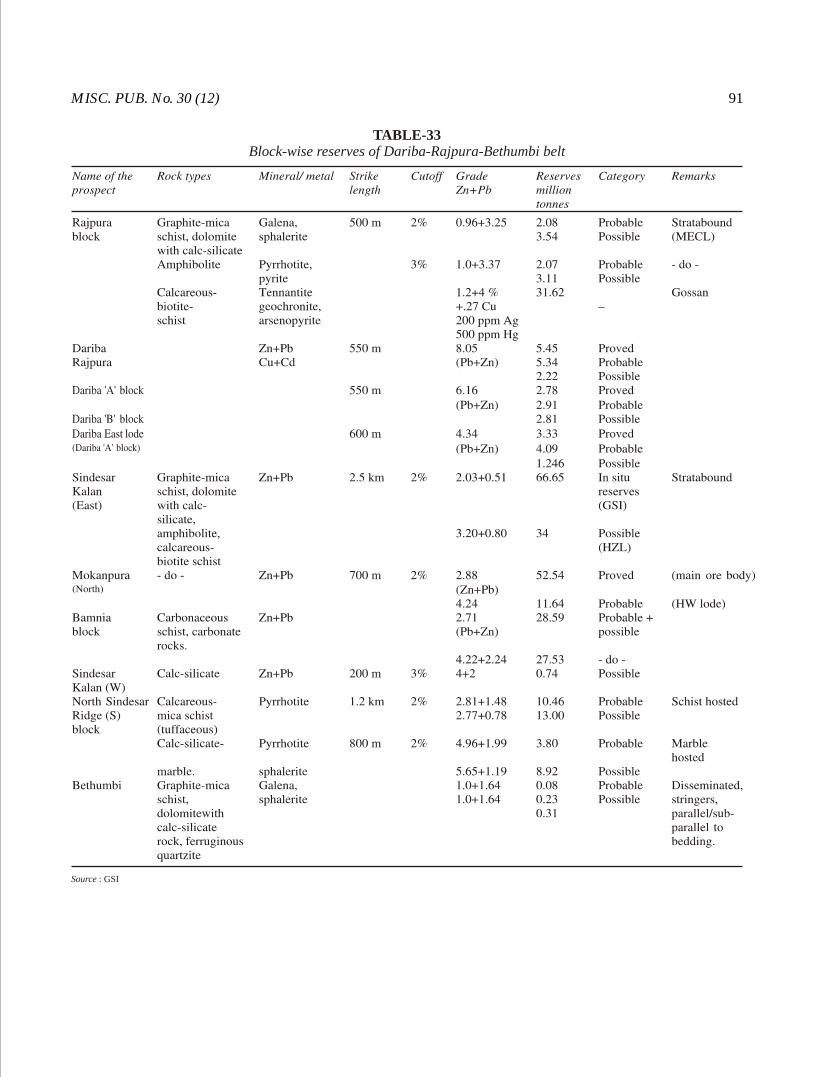
MISC. PUB. No. 30 (12) 91
TABLE-33Block-wise reserves of Dariba-Rajpura-Bethumbi belt
Source : GSI
GEOL, SURV. IND.92
The Dariba East lode occurring below the large water filled pond, east of Dariba hill, has been proved over a strike length of 600 m and up to a depth of 280 m. It is 2-35 m in width. The sulphide mineralization is mainly confined to graphitic mica schist.
Sindesar Kalan (East) block: The host rock is graphite mica schist. Pyrrhotite is the dominant sulphide with subordinate sphalerite, galena and pyrite. Rhythmic layering of sulphide is very characteristic. The ore zone was explored over 1.9 km strike length between 470 and 176 m RL. The average thickness of the ore zone is 86 m.
Mokanpura (North) block: Altogether five ore bodies have been delineated in Mokanpura (North) block. Of these, four bodies are hosted in the carbonaceous schist, namely main ore body 'A', HW lode, ore bodies 'B' and 'C'. The ore body 'A' is hosted in dolomitic chert. The main ore minerals are pyrrhotite, sphalerite and galena with subordinate pyrite, arsenopyrite, chalcopyrite and greenockite. Main ore body is correlatable with the Sindesar Kalan (East) main lode. It is 850 m in strike length and 102.87 m thick in northern section.
Bamnia block : In the Bamnia block, boreholes intersected carbonaceous schist and interbanded mica schist and metachert with calc-magnetite-silicate-bearing dolomitic marble lenses. The rocks strike
o o o oN30 E-S30 W and dip 70 -75 due E.
Carbonaceous schist, at places, is kyanite - staurolite and garnet-bearing and shows devitrified glass, sanidine etc. indicating felsic tuffaceous nature. Dolomitic marble lenses within the schist show Pb-Zn mineralization. Interbanded mica schist-metachert with lenses of calc-magnetite silicate-bearing dolomitic marble is the principal host rock to sulphide mineralization.
Pb-Zn ores are hosted by both carbonates (dolomitic marble lenses) and carbonaceous schist, but the former contains richer mineralization. Sulphide lodes are mostly concentrated along the hinges of F 2
folds. Sphalerite, galena and pyrrhotite are the principal sulphide minerals.
Three major ore bodies have been delineated within the marble in mica schist-metachert. They are BM-1, BMF-1 and BMF-2. Sulphides are present as bands, stringers, fracture-fillings and as replacement bodies. The marble is highly brecciated where the mineralization is of massive type. The carbonaceous
schist hosts lode CSL-2 and 3 and the marble hosts HWM-1. Of these, the most important is BM-1 (Bamnia Main lode-1) which has a strike length of 1,300 m with average width of 12.56 m. The lode has been investigated between 200 and 450 m RL.
North Sindesar Ridge (South) block: In the North Sindesar Ridge (South) block, Pb and Zn ores are hosted by schist (tuffaceous) and calc-silicate marble, mostly close to their interface. The ore bodies are discontinuous, arcuate, lense-shaped in plan and the ores are better concentrated along the crests of F folds. 2
Mineralization is also present along bedding and foliation. Though the richer lodes are hosted by marble and mica schist, the felsic volcanics also contain appreciable Zn and Pb sulphides. In the schist, the dominant sulphide is pyrrhotite with a little galena and sphalerite, whereas in the marble, the major sulphide minerals are pyrrhotite, sphalerite and galena with minor pyrite and arsenopyrite.
In the calc-silicate marble, the lode L-1 has a strike length of 800 m while there are two schist-hosted lodes, one each in the hanging wall and footwall of the marble-hosted lode L-1.
The lode L-1 has reserves of 7.94 million tonnes with 2.83% Pb, 7.77% Zn and 159 ppm Ag.
Bhilwara district
Agucha deposit
The Agucha Zn-Pb deposit discovered by the DGM, Rajasthan in 1977, is the single most important deposit of its kind in the country. The deposit is located near
o oAgucha (25 49': 74 44'). It is presently being worked as a 3,000 TPD opencast mine.
The Zn-Pb mineralization in Agucha occurs within an enclave of graphite-mica-sillimanite gneiss/schist within garnet-biotite-sillimanite gneiss containing bands of amphibolite, calc-silicate rock, intruded by aplite and pegmatite. The mineralised enclave forms doubly plunging synformal structure trending NE-SW
o owith steep dip (60 -70 ) to the southeast. The ore and host rocks of Agucha deposit have been subjected to higher amphibolite to granulite facies metamorphism. The deposit lies close to the ductile shear zone (DSZ) separating the high-grade granulitic rocks of the Sand Mata Complex on the west and gneiss and migmatites of the Mangalwar Complex in the east. The ore is completely recrystallised comprising coarse grains of sphalerite and some pyrite, pyrrhotite and galena.
MISC. PUB. No. 30 (12) 93
The deposit is stratabound and appears to be of sedimentary exhalative origin. Hindustan Zinc Ltd. (HZL) has estimated its ore reserves at 61.10 million tonnes over a strike length of 104 m with 13.48% Zn, 1.93% Pb and 54 ppm Ag.
Pur-Banera-Bhinder belt
The belt is a NE-SW to N-S trending, stretching for about 130 km from Banera in the north to Bhinder in the south. The metasedimentary rocks of the belt form linear enclave within a basement of feldspathic schist, garnet-staurolite schist and gneiss (Mangalwar Complex). The presence of old workings and slag dumps throughout the belt bear testimony to widespread mining and smelting activities during ancient times. The Pur-Banera-Sankli segment of the belt, in the north, differs markedly from Wari-Akola-Bhinder segment in the south in lithology and mineralization. In the northern part, BIF is associated with the Pb-Zn-Cu mineralization. It is absent in the south where only Cu mineralization is recorded.
Pur-Banera-Sankli segment: In the 50 km long Pur-Banera-Sankli segment, BIF represented by magnetite quartzite, magnetite-quartz-amphibole and magnetite-carbonate are the principal host rock for base metal mineralization. Garnet-rich magnetite-bearing calc-gneiss, calc-silicate rocks are also favoured host rock for sulphides. Two parallel zones of sulphide mineralization have been recognised in this segment. The eastern zone extends from Malikhera in the north to Tiranga in the south, over 34 km strike length, through Samodi-Dedwas, east of Dhulkhera-Ranningpura-Jaliya. The western zone extends for 40 km from Manpur in the north to south of Gurla in the south through Salampura, Dariba-Suras, west of Dhulkhera and east of Devpura. In both the zones, the Pb-Zn mineralization has been observed in the upper level and copper in the lower level. The mineralization exhibits stratiform nature. The main sulphide minerals are sphalerite, galena, chalcopyrite, pyrite and pyrrhotite. The sulphides occurs as bands alternating with the host rocks parallel to the bedding, as disseminations and stringers along fractures and cleavages and fillings along slip-planes and minor fold hinges. Of the different blocks explored in this segment, reserves have been proved in Banera RF (Pb-Zn) block, Malikhera (Pb-Zn) block, Mahua Khurd East (Pb-Zn) block, Mahua Khurd West (Pb-Zn) block, Devpura (Pb-Zn) block, North Dedwas (Pb-Zn) block, South Dedwas (Pb-Zn) block, Samodi (Pb-Zn)
block, Tiranga Hill (Pb-Zn) block, Rewara (Cu-Pb-Zn) block and Bhadali Khera (Pb-Zn) block, the details of which are summarised in Table-34.
(a) Samodi block (Pb-Zn): The rock unit includes calc-gneiss with calc-schist and quartz-biotite schist on the eastern flank of a ridge, a magnetite formation (magnetitic calc-gneiss, magnetite quartzite, magnetite- bearing schist) along the crest of the ridge and quartzite and garnetiferous mica schist in western part of the area.
The sulphide mineralization is localised in the magnetite formation and is traced over the entire strike length of 2 km. The width of the zone ranges from 64-140 m, averaging 120 m. The ore minerals are sphalerite, galena, pyrrhotite, pyrite, arsenopyrite, chalcopyrite and marcasite. There are two to six 'shoots' of richer zones within the wide mineralized zone.
(b) South Dedwas block (Pb-Zn): Garnetiferous mica schist is found in the western part of the block, calc-gneisses in the eastern part while the host quartz-amphibole-magnetite rock is found in between. The
o orock units trend N30 E-S30 W with steep westerly dip o oof 70 -80 .
The ore bodies are mainly stratiform but at places branching and interlinking. There are 34 lodes of which one lode, designated Lode M, shows remarkable persistence along both the strike and dip. In a strike length of 1.7 km, the lodes have been tested at three levels at 50, 100 and 150 m depth below the surface.
Sirohi district
Deri deposit: A small Pb-Zn-Cu deposit in the Deri o oarea (24 23': 72 50') has been discovered by the GSI.
Four mineralized zones have been delineated which extend over a total strike length of 660 m. Mineralization, generally restricted to the quartz-chlorite-amphibolite schist and talc-chlorite schist, is controlled by prominent shear zones and strike faults. Exploration carried out have indicated the inferred reserves of 0.80 million tonnes containing 17.13% total metal content (Zn 9.12%, Pb 6.87% and Cu 1.14%).
Ajmer district
Ajmer lead-zinc belt
The Ajmer Pb-Zn belt extends over a strike length of 60 km from Kharwa (37 km southwest of Ajmer) in the southwest to Hoshiara in the northeast (13 km northwest of Kishangarh). Apart from the ancient mine working recorded at Taragarh (Shishakhan), Lohakhan and
- -

GEOL, SURV. IND.94
TABLE-34Pur Banera-Bhinder belt (Pb-Zn-Cu)
Source : GSI.(*total reserves)
MISC. PUB. No. 30 (12) 95
Ghugra, a few doubtful old pits are observed at Kayar while oxidised zones/gossans are scarce and only a few scattered exposures are observed at Kayar, Madarpura and Ghugra. At Mata Dongri, slightly oxidised lead zinc ores occur in a quarry section within impure marble and calc-silicate rock. Large part of the area to the northeast of Lohakhan and Ghugra is a covered flat terrain. The ground follow up surveys to check airborne EM anomalies associated with magnetic features led to the discovery of deposits at Ghugra (Pb-Zn), Kayar (Pb-Zn)
2and Madarpura (Zn) in an area for about 20 km .
Ghugra lead-zinc deposit: The sulphide minerali-zation is mostly hosted by calc-silicate rocks while mineralization is also noticed in metapsammopelites and footwall quartzites. The main sulphide ores are sphalerite, galena with subordinate pyrrhotite and chalcopyrite. The ore body is emplaced within a northerly plunging synformal closure. Geophysical surveys led to the delineation of the target over a strike length of 2.0 km. Exploration by drilling resulted in delineating sulphide mineralization over a strike length of 1.10 km and down to a vertical depth of 200 m.
Mineral reserves (probable and possible) of 9.0 million tonnes with average grade of 5.7% (Pb 2.56% + Zn 3.22%) at 4% cutoff have been estimated. The associated metals include Cu, Ni, Co, Ag, Cd and Hg.
Kayar zinc-lead deposit: Ground evaluation of significant zones of AEM anomalies found in association with a circular magnetic signature around Kayar by GSI helped in indentifing a zone of Zn Pb mineralization for a cumulative strike length of 1.06 km within the metasediments of the Ajmer Formation (Ajabgarh Group of the Delhi Supergroup).
Exploration has established mineral reserves (probable and possible) of 9.2 million tonnes with 12% Zn and 1.2% Pb and minor amount of copper. The associated metals include silver, cadmium and mercury. Tin and tungsten are also recorded.
The sulphide mineralization is mainly associated with graphitic quartz-mica schist, although it also occurs in quartzite and calc-silicate rock. These rocks are profusely invaded by pegmatite and quartz veins. The calc-silicate rocks show typical contact metamorphic skarn assemblages, characterised by the presence of diopside, subordinate clinozoisite and occasional wollastonite, forsterite and chondrodite. Sulphides occur as fracture-fillings along fissures, veins, cleavages and foliation planes. The dominant
-
sulphide ore is sphalerite with galena in subordinate amounts. Other sulphides include chalcopyrite, pyrite, pyrrhotite, cubanite and pentlandite.
Madarpura deposit: Exploration was carried out on an antiform complementary to the Ghugra synform. The host rock is calc-silicate rock (wollastonite-diopside-tremolite-bearing) and dolomitic limestone profusely intruded by pegmatite and quartz veins. Sulphide mineralogy is dominated by sphalerite with chalcopyrite and pyrrhotite in subordinate amounts. Other constituents in minor amounts include pyrite, marcasite, galena and molybdenite. Ore zones are confined to schistosity planes and minor fold crests.
Exploration by drilling indicated significant zones of zinc minearlization over a strike length of 1 km. Zinc content is found ranging from 0.91 to 5.51% over varying widths of 1.30-19.27 m; maximum value of lead recorded is 1.40% over a width of 1.27 m and copper content is generally low (less than 0.22%). Other associated metals include Cd, Hg and Mo. The deposit is considered to be of low-grade (2-3% Zn) and a few million tonnes of reserves have been identified.
East Lohakhan: On the northern outskirts of Ajmer city, this Pb-Zn prospect is located on a magnetic high and is associated with six-channel EM anomalies. The mineralization is hosted by calc-silicate rock, co-folded with quartzite and mica schist in the form of an asymmetrical southerly plunging fold. There are a number of old workings within the calc-silicate band along the axis and the limbs close to the fold closure. The available subsurface data indicates shallow ore body (40-60 m below the surface) with Pb dominating over Zn, i.e. around 2 : 1 metal ratio.
Mata Dongri block: Ground evaluation of aero EM anomalies associated with magnetic signature led to a find of Pb-Zn mineralization hosted within carbonate rocks, marble and calc-silicate rocks. In a quarry section, pockets of sulphide ore (slightly oxidised) containing sphalerite with galena were observed.
Bhimyo block: The metasedimentary rocks comprising quartzite, calc-silicate and mica schists are characterised by a distinct magnetic signature. Geochemical sampling of bed rock (oxidised zone over the calc-silicate rock) indicated Pb values up to 9,800 ppm and Zn 13,500 ppm. Soil sampling also indicated zinc anomaly over a strike length of 750 m. The prospect is under exploration.
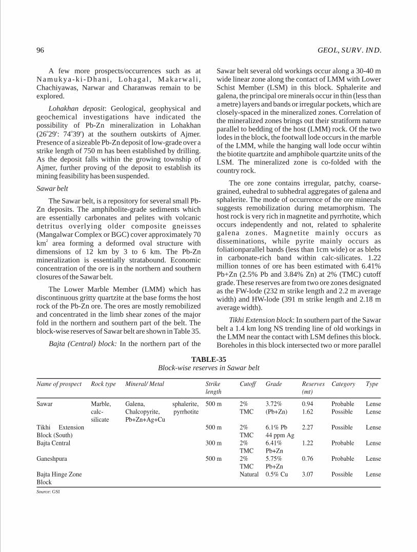
GEOL, SURV. IND.96
A few more prospects/occurrences such as at N amuky a -k i -D h an i , Lohaga l , M aka rw a l i , Chachiyawas, Narwar and Charanwas remain to be explored.
Lohakhan deposit: Geological, geophysical and geochemical investigations have indicated the possibility of Pb-Zn mineralization in Lohakhan
o o(26 29': 74 39') at the southern outskirts of Ajmer. Presence of a sizeable Pb-Zn deposit of low-grade over a strike length of 750 m has been established by drilling. As the deposit falls within the growing township of Ajmer, further proving of the deposit to establish its mining feasibility has been suspended.
Sawar belt
The Sawar belt, is a repository for several small PbZn deposits. The amphibolite-grade sediments which are essentially carbonates and pelites with volcanic detritus overlying older composite gneisses (Mangalwar Complex or BGC) cover approximately 70
2km area forming a deformed oval structure with dimensions of 12 km by 3 to 6 km. The Pb Zn mineralization is essentially stratabound. Economic concentration of the ore is in the northern and southern closures of the Sawar belt.
The Lower Marble Member (LMM) which has discontinuous gritty quartzite at the base forms the host rock of the Pb Zn ore. The ores are mostly remobilized and concentrated in the limb shear zones of the major fold in the northern and southern part of the belt. The block-wise reserves of Sawar belt are shown in Table 35.
Bajta (Central) block: In the northern part of the
-
-
-
Sawar belt several old workings occur along a 30 40 m wide linear zone along the contact of LMM with Lower Schist Member (LSM) in this block. Sphalerite and galena, the principal ore minerals occur in thin (less than a metre) layers and bands or irregular pockets, which are closely-spaced in the mineralized zones. Correlation of the mineralized zones brings out their stratiform nature parallel to bedding of the host (LMM) rock. Of the two lodes in the block, the footwall lode occurs in the marble of the LMM, while the hanging wall lode occur wihtin the biotite quartzite and amphibole quartzite units of the LSM. The mineralized zone is co-folded with the country rock.
The ore zone contains irregular, patchy, coarse-grained, euhedral to subhedral aggregates of galena and sphalerite. The mode of occurrence of the ore minerals suggests remobilization during metamorphism. The host rock is very rich in magnetite and pyrrhotite, which occurs independently and not, related to sphalerite galena zones. Magnetite mainly occurs as disseminations, while pyrite mainly occurs as foliationparallel bands (less than 1cm wide) or as blebs in carbonate-rich band within calc-silicates. 1.22 million tonnes of ore has been estimated with 6.41% Pb+Zn (2.5% Pb and 3.84% Zn) at 2% (TMC) cutoff grade. These reserves are from two ore zones designated as the FW-lode (232 m strike length and 2.2 m average width) and HW-lode (391 m strike length and 2.18 m average width).
Tikhi Extension block: In southern part of the Sawar belt a 1.4 km long NS trending line of old workings in the LMM near the contact with LSM defines this block. Boreholes in this block intersected two or more parallel
-
TABLE-35Block-wise reserves in Sawar belt
Source: GSI
MISC. PUB. No. 30 (12) 97
lodes with coarse-grained galena, pyrrhotite, occasional chalcopyrite and sphalerite. The grade and width of the ore zone is better in the southern 500 m part of this block.
In the Tikhi Extension block, the host rock LMM is intensely silicified in the mineralized zone. A steeply dipping straight line disposition of the zones is suggested. The sulphide lodes occur as lenses 150 m to 200 m long and have wide variation of grade and width. In the southern part of Tikhi Extension block the grade varies from 2.52% to 17.71% Pb and width from 1.31 m to 8.77 m.
The southern 500 m part of the Tikhi Extension block has indicated a metal zonation with concentration of lead in the hanging wall side and zinc in the footwall side. There is a separation of 50-80 m between the two types of lode. Total reserves of lead-rich ore in this sector of the Tikhi Extension block is estimated at 2.27 million tonnes of 6.15% Pb and 44 ppm Ag at 2% cutoff.
Sawai Madhopur district
Chauth-ka-Barwara deposit: The Banjari mine at o oChauth-ka-Barwara (26 03': 76 00') is a well-known old
working for lead. Pb mineralization, associated with a fault zone, is exposed along an old opencast working measuring 100 m long and about 8 m (average) deep. The surface exposures are of limited extent due to covered terrain. The rock types in the area include shale, slate, quartzite and impure limestone belonging to the Hindoli Group of the Bhilwara Supergroup. The mineralization is highly-lenticular, patchy and impersistent along strike and dip and occurs as disseminations, stringers and veinlets of galena with minor pyrite and chalcopyrite. The drilling in the area has established presence of a Pb-body over a strike length of 240 m.
Chittaurgarh district
Pur-Banera belt
Pb-Zn mineralization with Cu is reported to occur at o o oRewara (25 06': 74 22') and Karjia Khera (25 07' :
o74 23').
Rewara block (Pb-Zn-Cu): The area is mostly soil covered with scanty exposures. The rock units are mica schist, staurolite-garnet-mica shist, and andalusite-bearing mica schist, magnetite quartzite, quartzite, calc-gneiss, calc-schist, dolomite and calc-silicate rocks. They are folded into a northerly plunging synform.
Drilling has established Cu-Pb-Zn mineralization
on both limbs of the synform over a strike length of 1.6 km. Eight lodes on the eastern limb and four on the western limb have been defined.
Mineralization is stratabound and occurs interbanded with amphibole-quartz-carbonate gneiss and quartz-amphibole-garnet gneiss. Quartz-sericite-biotite schist carries the Pb-Zn mineralization. There is a distinct zoning with Zn-rich portions at the core, Cu-Pb-Zn in the middle and Cu towards the footwall. The sulphides present are galena, chalcopyrite, sphalerite and pyrite. Reserves of 1.2 million tonnes of possible and probable category with 0.7% Cu, 5.4% Pb and 0.4% Zn have been estimated.
Karjia Khera: The mineralization is recorded in the eastern limb of a syncline which is the northern continuation of the Rewara syncline. The mineralization, encountered in the boreholes over a strike length of 800 m, is poor. Sulphide disseminations include galena, sphalerite, pyrite, pyrrhotite and chalcopyrite.
Indication of galena in the form of finely crystalline disseminations is present in Bamov. Specks and stringers of galena are also noticed near Pandoli and Sopura.
LIGNITE
Lignite, a low-grade fossil fuel, represents an intermediate stage in the alteration of wood into coal. It is dark-brown to blackish-brown in colour, carries a good amount of moisture and often crumbles into powder on drying. In Rajasthan, large deposits of lignite occur in Tertiary formations of Middle Eocene age in the Barmer, Jaisalmer and Nagaur basins falling in Barmer, Jaisalmer and Bikaner-Nagaur districts, respectively. Total reserves of lignite in India and Rajasthan is given in Table-36.
Bikaner-Nagaur districts
Lignite-bearing two sub-basins are recognised, namely, the Palana-Kolayat embayment and Merta Road sub-basin.
Palana-Kolayat sub-basin: The lignite is associated with the Palana Formation (Middle Eocene). The lignite occurrences are disposed along this belt for about 70 km long and 30 km wide stretch. The belt is generally thicker to the south and thins out to the north. The thickness of the lignite along the axis of the fold is 7-12 m. At Palana, a seam having an average thickness of about 6.5 m has been worked till the year 1968. DMGR estimated the total reserves of
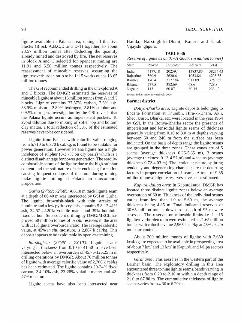
GEOL, SURV. IND.98
lignite available in Palana area, taking all the five blocks (Block A,B,C,D and D-1) together, to about 23.57 million tonnes after deducting the quantity already mined and destroyed by fire. The net reserves in block A and C selected for opencast mining are 11.91 and 5.56 million tonnes respectively. The reassessment of mineable reserves, assuming the lignite/overburden ratio to be 1: 15 works out as 13.65 million tonnes.
The GSI recommended drilling in the unexplored A and C blocks. The DMGR estimated the reserves of mineable lignite at about 16 million tonnes from A and C blocks. Lignite contains 37.57% carbon, 7.3% ash, 38.9% moisture, 2.89% hydrogen, 2.81% sulphur and 0.92% nitrogen. Investigation by the GSI reveals that the Palana lignite occurs as impersistent pockets. To avoid dilution due to mixing of softer top and bottom clay matter, a total reduction of 30% of the estimated reserves have to be considered.
Lignite from Palana, with calorific value ranging from 5,710 to 6,370 k cal/kg, is found to be suitable for power generation. However Palana lignite has a high-incidence of sulphur (3-3.7% on dry basis) which is a distinct disadvantage for power generation. The readily-combustible nature of the lignite due to the high-sulphur content and the soft nature of the enclosing formation causing frequent collapse of the roof during mining make lignite mining at Palana an uneconomic proposition.
o oGurha (27 55': 72 58'): A 6.10 m thick lignite seam at a depth of 86.40 m was intersected by GSI at Gurha. The lignite, brownish-black with thin streaks of huminite and a few pyrite crystals, contains 5.8-12.41% ash, 34.67-42.20% volatile mater and 39% huminite fixed carbon. Subsequent drilling by DMG/MECL has proved 50 million tonnes of in situ reserves in the area with 1:15 lignite/overburden ratio. The average calorific value, at 45% in situ moisture, is 2,867 k cal/kg. This deposit appears to be exploitable by open-cast mining.
o oBarsinghsar (27 45' : 73 10'): Lignite seams varying in thickness from 0.10 to 41.50 m have been intersected below an overburden of 45.75-125.25 m in drilling operations by DMGR. About 70 million tonnes of lignite with average calorific value of 2,700 k cal/kg has been estimated. The lignite contains 20-24% fixed carbon, 2.4-10% ash, 23-28% volatile matter and 42-47% mositure.
Lignite seams have also been intersected near
Hadda, Narsingh-ki-Dhani, Raneri and Chak-Vijayshinghpura.
TABLE-36Reserve of lignite as on 01-01-2006; (in million tonnes)
Source: Indian minerals yearbook, 2006.
Barmer district
Botiya-Bharka area: Lignite deposits belonging to Eocene Formation at Thumbli, Hira-ki-Dhani, Akli, Sheo, Unror, Bharka, etc. were located in the year 1964 by GSI. In the Botiya-Bharka sector the presence of impersistent and lensoidal lignite seams of thickness generally varing from 0.10 to 3.0 m at depths varying between 60 and 240 m from the surface has been indicated. On the basis of depth range the lignite seams are grouped in the three zones. These zones are of 5 seams (average thickness 0.26-5.85 m), 3 seams (average thickness 0.13-4.57 m) and 4 seams (average thickness 0.72-4.03 m). The lenticular nature, splitting tendency and degenerating character are the deterring factors in proper correlation of seams. A total of 9.35 million tonnes of lignite reserves have been estimated.
Kapurdi-Jalipa area: In Kapurdi area, DMGR has located three distinct lignite zones below an average overburden of 60 m. Thickness of the individual seams varies from less than 1.0 to 5.60 m, the average thickness being 4.85 m. Total indicated reserves of 30.65 million tonnes down to a depth of 95 m were assessed. The reserves on mineable limits i.e. 1 : 15 lignite/overburden ratio were estimated at 21.65 million tonnes with calorific value 2,965 k cal/kg at 45% in situ moisture content.
About 200 million tonnes of lignite with 2,650 kcal/kg are expected to be available in prospecting area
2 2of about 7 km and 13 km in Kapurdi and Jalipa sectors respectively.
Giral area: This area lies in the western part of the Barmer basin. The exploratory drilling in this area encountered three to nine lignite seams/bands varying in thickness from 0.20 to 2.10 m within a depth range of 21.0 to 67.80 m. The cummulative thickness of lignite seams varies from 4.30 to 6.29 m.

MISC. PUB. No. 30 (12) 99
Nagaur district
In the Merta Road sub-basin lignite seams have been reported at an average depth of 100-120 m. The thickness of these seams varies from 0.55 to 6.05 m. The in situ reserves would be of the order of 11 million tonnes as postulated.
Merta Road block: Drilling operations by DMGR have intersected 3.19 m thick lignite seam. Total reserves are of the order of 24 million tonnes. The lignite with 45% in situ moisture has claorific value of 2,650 kcal/kg, 12.42% ash, 24% volatile matter and 18.25% with fixed carbon.
Mokala-Indawar block: Lignite seams intersected by drilling, near Mokala and Indawar are estimated to yield another 27 million tonnes. The calorific value of the lignite is 2,760 k cal/kg. The average quality of lignite (at 17.08% in situ moisture) is 17.63% ash, 37.65% volatile matter, 27.52% fixed carbon with 4,139 k cal/kg calorific values.
Igair-Chhappra area: In a dug well a lignite seam, about 5-6 m thick was observed lying at a depth of about 47 m. Drilling by DMGR has confirmed the presence of 4.30-6.00 m thick lignite seam in the area.
Kuchera-Igair area: Drilling in the area has indicated lignite seam of about 0.30-3.80 m in thickness under 56.70-64.75 m thick overburden. The average quality of lignite (at 45% in situ moisture) is 11.23% ash, 23.89% volatile matter, 19.87% fixed carbon and 2,824 k cal/kg calorific values.
LIMESTONE
Limestone is one of the most important industrial mineral required in the manufacture of lime, cement, chemicals (soda-ash, caustic-soda, bleaching powder,
calcium carbide etc.), fertilizer (ammonium nitrate etc.) and as a flux in iron and steel, ferro-alloy and other metallurgical industries.
Limestone occurs in almost all the districts of the State, but important deposits are located in Ajmer, Bundi, Chittaurgarh, Jodhpur, Nagaur, Pali, Sirohi and Jaisalmer districts. Total production of limestone in India during 2005-06 and Rajasthan's contribution in it is given in Table-37A. Total reserve is given in Table-37.
Ajmer districtoLimestone deposits are found at Sheopura (26 01':
o o o o74 23'), Lulwa (26 04': 74 24') and Kesarpura (26 09': o74 27'). The limestone bands within calc-schists of the
Delhi Supergroup extend for 13 km length with an average width of 1.5 km. The samples analyse 40.4-50.8% CaO, up to 2.3% MgO and less than 4% insolubles. Indicated and inferred reserves of 424 and 254 million tonnes respectively have been estimated with average 40% CaO content. The limestone is considered suitable for cement manufacture. Isolated occurrences of limestone have been reported from
o o o oTilona (26 39': 74 57'), Hatondi (26 16': 74 39'), o o oGaneshpura (25 48': 75 14'), Govindpura (25 48':
o o o o75 13'), Jaswantapura (25 47': 75 15'), Sawar (25 45': o o o o75 13'), Ghorarel (25 51': 74 08') and Bilwas (25 53': o74 14').
TABLE-373Reserve of limestone as on 01-04-2005; (in 10 tonnes )
Source: Indian minerals yearbook, 2006.
TABLE-37A3Production of limestone (2005-06); (in 10 tonnes)
Source: Indian minerals yearbook, 2006
GEOL, SURV. IND.100
Bundi district
Limestone deposits have been reported from Bundi o o o o(25 27': 75 38'), Lakheri (25 40': 76 11') and Satur o o(25 28': 75 33'). Limestone bands occur enveloped
between the Ganurgarh Shales and the Lower Bhander Sandstone of the Vindhyan Supergroup. The limestone is commonly massive, very fine-grained and breaks with conchoidal fracture. On an average, the limestone analyses 47.76% CaO, 1.5% MgO, 2.8% SiO , 1.1% 2
Al O and 0.7% Fe O . A total reserve of 850 million 2 3 2 3
tonnes with 42.73% CaO has been estimated. The limestone is considered suitable for cement manufacture.
Chittaurgarh district
Limestone deposits are found near Chittaurgarh o o o o(24 50': 74 35'), Nimbahera (24 35': 74 40'), Sirohi o o(25 55': 74 40') and Parsoli. The limestone horizon
belongs to the Nimbahera Formation of Lower Vindhyan and is mostly of cement-grade.
Nimbahera Limestone with 42-49% CaO and low MgO content is mined at Nimbahera-Phalwa and at Bhenra-Dallakhera-Damdama to feed the cement factories at Nimbahera and Chanderi. Reserves of over 300 million tonnes have been estimated in the Bhenra-Dallakhera-Damdama areas. Total reserves of this limestone are put at 624.35 million tonnes, by IBM.
Jodhpur-Nagaur-Pali districts
Limestone deposits are scattered over a 100 km belt o obetween Sojat (25 55': 73 44') in Pali district, Bilara
o o o o(26 11': 73 41') and Basa (26 00': 73 40') in Jodhpur o o o
district and Mundwa (27 03': 73 50') and Gotan (26 39': o73 45') in Nagaur district. The deposits include
chemical and flux-grade limestone in the calcareous horizons of the Gotan Formation of the Bilara Group belonging to the Marwar Supergroup. The limestone, massive to thinnly-bedded and laminated at places, is grey, dark-grey, white or pale white and light pink in colour. Fine- to medium-grained and, at places very coarsely crystalline, the limestone is associated with dolomite, cherty limestone and chert. There are more than 160 prospects in this belt, some of which are producing several thousand tonnes of chemical and flux-grade limestone. The analysis of the samples has indicated 49.38-54.02% CaO, 0.03-0.59% MgO and 2.03-7.66% insolubles. The total reserves have been estimated to the order of 54 million tonnes, of which about 29 million tonnes are of chemical grade (25 million tonnes in Bilara-Mundwa belt in Jodhpur and
Nagaur districts, 4 million tonnes in Gotan area, Nagaur district) and the remaining 25 million tonnes in BilaraMundwa belt is of flux-grade.
oLimestone band found near Deoli Hulan (25 55': o73 54') in Pali district extends over a strike length of 9
km. The chemical analysis of the samples has indicated 45.63% CaO, 0.16% MgO and 10.56% insolubles. Reserves of 12 and 23 million tonnes with 42.03% CaO of possible and probable categories respectively have been estimated. The limestone is considered suitable for
ocement manufacture. The limestone near Ras (26 15': o74 10') is generally crystalline and greyish-white to
blackish-grey in colour. Proved reserves of 45.37 million tonnes and possible reserves of 37.82 million tonnes in the area have been indicated by the DMGR.
Sawai Madhopur district
An estimated reserves of 100 million tonnes have been indicated from the limestone deposits at Naraoli
o o o o(26 15': 76 15'), Jhirota (25 05': 76 21') and Phalodi. The limestone horizon is of Lower Bhander Limestone Formation of the Vindhyan Supergroup.
Jaipur districtoLimestone deposits occur near Kotputli (27 12':
o76 12'). The limestone is grey to white in colour. The DMGR has estimated reserves of 586 million tonnes. In
o oMaonda (27 49': 75 50') crystalline and grey limestone has been explored by DMGR and reserves of 101 million tonnes have been indicated. Impure limestone
o odeposits are also found near Raori (26 57': 75 59'), Naila o o o o o(26 52': 75 54'), Bandhia (26 55': 75 59'), Siroi (26 48':
o o o o o75 54'), Harori (26 53': 75 58'), Raialo (27 05': 76 16'), o o o oNimla (27 04': 76 10') and Dabla (27 54': 75 56'). The
Dabla occurrence is being worked.
Sikar district
The crystalline greyish-white limestone with osiliceous and dolomitic bands near Patan (27 25':
o74 30') has been investigated by the DMGR. Estimated reserves of 6.98 million tonnes with 46-54% CaO and 0.2-3.5% MgO and 2.22 million tonnes of possible category have been estimated. Other occurrences are
o oalso reported from Raipur (27 44': 75 58'), Jhingar o o o o(27 38': 76 01') and Saladipura (27 38': 75 31').
Sirohi district
Occurrences of limestone are found at Abu Road o o o o(24 28': 72 47'), Dhanwan (24 31': 72 47'), Akhra o o o o(24 30': 72 50'), Pindwara (24 32': 72 52'), Murthala
MISC. PUB. No. 30 (12) 101
o o o o(24 31': 72 49'), Kirathi (24 32': 72 50') and Mawal o o(24 26': 72 45'). Possible reserves of 2,036 million
tonnes have been indicated for the limestone deposits at Pindwara-Abu Road belt.
Dungarpur district
The compact limestone near Sabla and Loharia with shades of pink, grey and white colour have been investigated by DMGR and reserves of 30 million tonnes with 45% CaO and low-magnesia have been proved.
Banswara district
At Talwara, the DMGR has proved 25 million tonnes of reserves with 46.28% CaO, 0.30% MgO and 24.34% SiO .2
Bikaner district
A small occurrence of impure limestone has been o orecorded at Srikolayatji (27 50': 72 57').
Jaisalmer district
Khuiala and Bandha limestone deposits (Lower to Middle Eocene) fall in a 100 km long curvilinear belt, from south of Sam to Bandha. The limestone beds are horizontal to sub-horizontal with low-rolling dips and are practically devoid of overburden except at a few places, where the Quaternary sedimentary cover is up to 2.0 m thick. The limestone is fine-grained, hard and compact with fossils, casts and moulds. Free quartz grains and secondary silica are noted only at a few places. Small orthoquartzite lenses are occasionally present.
Discovered and investigated by GSI, the reserves are estimated at about 560 million tonnes down to 1 m (pit depth) and an additional reserve of about 2,500 million tonnes further below. Out of 560 million tonnes, 300 million tonnes are of chemical-grade and 260 million tonnes of the rest is of flux-grade. Detailed investigations by DMGR and RSMDC have revealed the thickness of the limestone to be 4-6 m. The reserves estimated by them are 272 million tonnes with 52-54% CaO and 1.34% SiO and 185 million tonnes with 52-2
54% CaO and 1.8% SiO in Sanu block and 108.6 2
million tonnes with 53.4% CaO and 1.54% SiO in 2
Habur block.
Limestone from Sanu mine (RSMDC) and Habur mine is hard and remains compact after calcination at
o950 C for two hours, and develops no cracks. This limestone analyses 54.20% CaO, 0.54% SiO and 54.40% 2
CaO, 0.72% SiO respectively and is of SMS grade. 2
MAGNESITE
Magnesite, a hard white mineral, is the chief source of magnesium. Its importance lies in its property to withstand high temperature. It is extensively used in the manufacture of refractory bricks used in steel-making furnaces, in the manufacture of some special types of cement (sorel cement) and in glass and rayon industry.
Magnesite deposit near Sarupa-Chhaja in Ajmer district is known to have reserves of about 1.5 million tonnes of magnesite with an average grade of 50% MgCO (24%MgO). Occurrences have also been reported 3
o ofrom Bhimana (24 50': 73 13') in Pali district and Lewa-o oka-Gurha (25 09': 73 44') area in Udaipur district.
MANGANESE
Manganese finds its main use in the manufacture of pig-iron and steel, ferro-manganese (a chief ingredient for production of manganese-steel), chemicals and in dry battery cells. India possesses vast resources of manganese ores and is ranked third in the world in the production of manganese. It is second to iron ore in terms of export. In Rajasthan manganese ore deposits of significance occur in Banswara district.
Banswara district
Manganese ore deposit are confined to a belt o oextending from Gararia (23 19': 74 17') to Ratimauri
o o(23 10': 74 20') for a distance of 20 km. The main deposits associated with the Aravalli phyllites are
o o olocated at Sivnia (23 20': 74 16'), Khunta (23 19': o o o o o74 17'), Ghatia (23 19': 74 18'), Itala (23 30': 74 19'),
o o o oTameshra (23 18': 74 19') and Kheria (23 15': 74 21'). All along the belt manganese is exposed in numerous workings and prospecting pits. The deposits hold a possible reserves of about 3,30,000 tonnes of low-grade ore and about 32,900 tonnes of high-grade ore within a depth of 9.14 m from bottom of the existing open pits.
Manganese, in the low-grade ores, varies from 27.29 to 35.45% with Mn/Fe ratio varying between 6 and 12.2. The high-grade ores contain 46.72-52.22% Mn with a very high Mn/Fe ratio. The only promising part of the deposit appears to be the Tamesra-Kheria section which contains 97% of the reserves of high-grade ore, in addition to the reserves of the low-grade ores.
Manganese ores of Banswara district have been intermittently mined since 1945. The mining activity has been suspended due to its low-grade. The main problem for utilising the Banswara ore is its low-grade
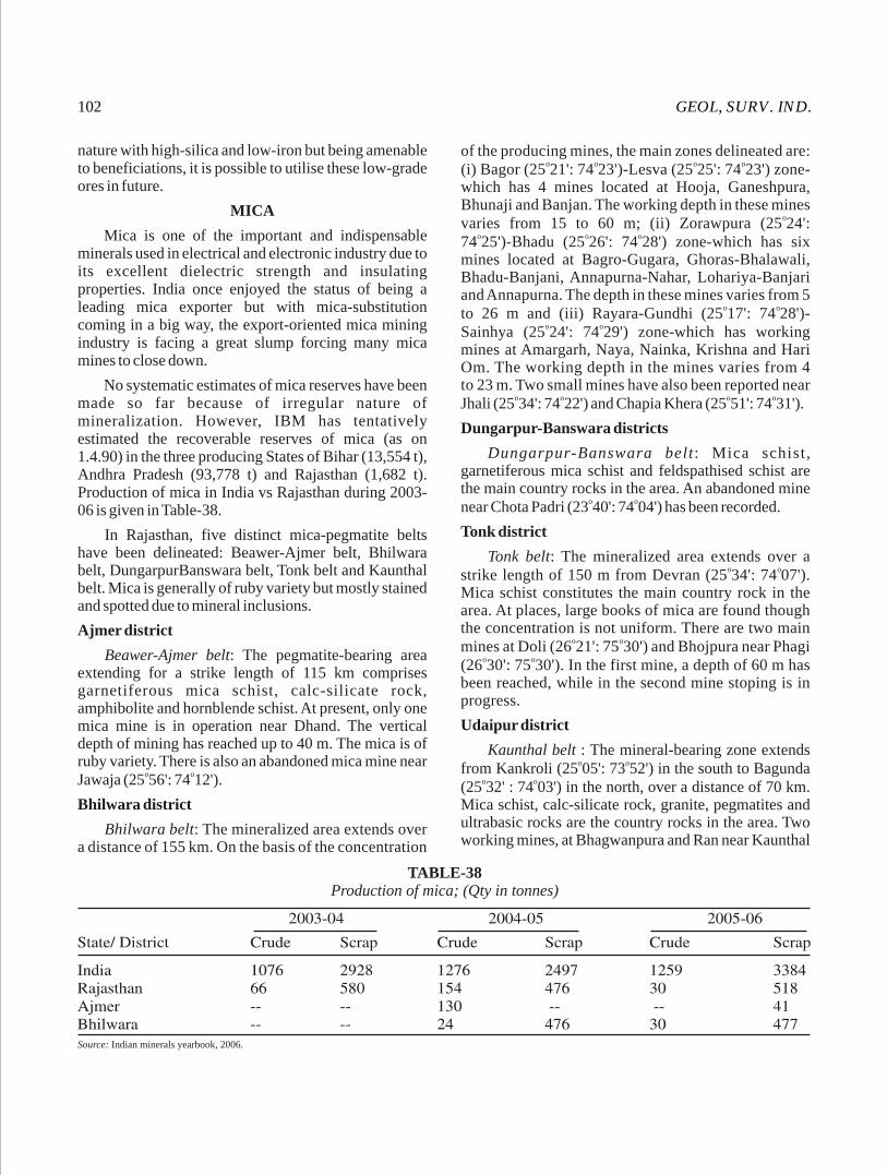
GEOL, SURV. IND.102
nature with high-silica and low-iron but being amenable to beneficiations, it is possible to utilise these low-grade ores in future.
MICA
Mica is one of the important and indispensable minerals used in electrical and electronic industry due to its excellent dielectric strength and insulating properties. India once enjoyed the status of being a leading mica exporter but with mica-substitution coming in a big way, the export-oriented mica mining industry is facing a great slump forcing many mica mines to close down.
No systematic estimates of mica reserves have been made so far because of irregular nature of mineralization. However, IBM has tentatively estimated the recoverable reserves of mica (as on 1.4.90) in the three producing States of Bihar (13,554 t), Andhra Pradesh (93,778 t) and Rajasthan (1,682 t). Production of mica in India vs Rajasthan during 2003-06 is given in Table-38.
In Rajasthan, five distinct mica-pegmatite belts have been delineated: Beawer-Ajmer belt, Bhilwara belt, DungarpurBanswara belt, Tonk belt and Kaunthal belt. Mica is generally of ruby variety but mostly stained and spotted due to mineral inclusions.
Ajmer district
Beawer-Ajmer belt: The pegmatite-bearing area extending for a strike length of 115 km comprises garnetiferous mica schist, calc-silicate rock, amphibolite and hornblende schist. At present, only one mica mine is in operation near Dhand. The vertical depth of mining has reached up to 40 m. The mica is of ruby variety. There is also an abandoned mica mine near
o oJawaja (25 56': 74 12').
Bhilwara district
Bhilwara belt: The mineralized area extends over a distance of 155 km. On the basis of the concentration
of the producing mines, the main zones delineated are: o o o o(i) Bagor (25 21': 74 23')-Lesva (25 25': 74 23') zone-
which has 4 mines located at Hooja, Ganeshpura, Bhunaji and Banjan. The working depth in these mines
ovaries from 15 to 60 m; (ii) Zorawpura (25 24': o o o74 25')-Bhadu (25 26': 74 28') zone-which has six
mines located at Bagro-Gugara, Ghoras-Bhalawali, Bhadu-Banjani, Annapurna-Nahar, Lohariya-Banjari and Annapurna. The depth in these mines varies from 5
o oto 26 m and (iii) Rayara-Gundhi (25 17': 74 28')-o oSainhya (25 24': 74 29') zone-which has working
mines at Amargarh, Naya, Nainka, Krishna and Hari Om. The working depth in the mines varies from 4 to 23 m. Two small mines have also been reported near
o o o oJhali (25 34': 74 22') and Chapia Khera (25 51': 74 31').
Dungarpur-Banswara districts
Dungarpur-Banswara belt: Mica schist, garnetiferous mica schist and feldspathised schist are the main country rocks in the area. An abandoned mine
o onear Chota Padri (23 40': 74 04') has been recorded.
Tonk district
Tonk belt: The mineralized area extends over a o ostrike length of 150 m from Devran (25 34': 74 07').
Mica schist constitutes the main country rock in the area. At places, large books of mica are found though the concentration is not uniform. There are two main
o omines at Doli (26 21': 75 30') and Bhojpura near Phagi o o(26 30': 75 30'). In the first mine, a depth of 60 m has
been reached, while in the second mine stoping is in progress.
Udaipur district
Kaunthal belt : The mineral-bearing zone extends o ofrom Kankroli (25 05': 73 52') in the south to Bagunda
o o(25 32' : 74 03') in the north, over a distance of 70 km. Mica schist, calc-silicate rock, granite, pegmatites and ultrabasic rocks are the country rocks in the area. Two working mines, at Bhagwanpura and Ran near Kaunthal
TABLE-38Production of mica; (Qty in tonnes)
Source: Indian minerals yearbook, 2006.

MISC. PUB. No. 30 (12) 103
o orailway station and two near Sardargarh (25 14': 73 58'), are present in the area. Besides these, a number of prospecting pits are also seen. The depth attained in these mines varies from 10 to 75 m.
MOLYBDENUM
Molybdenum is mainy used as an alloying constituent in steel industry for imparting strength, elasticity and resistance to shock and fatigue. Metal molybdenum finds application in electrical industry where it is used for contact points, thermocouples and electrodes. Molybdenum-tungsten alloy is used as filament support, in incandescent electric lamps, wireless-receivers and transmitter valves. In India the entire requirement of this metal is met by imports.
Molybdenum does not occur in nature in its free or native state. In India molybdenum is generally found associated with Pb, Zn and Cu ores and is recovered as by product concentrates. All India recoverable reserves (as on 1.4.93) are placed at 8.4 million tonnes of ore.
In Rajasthan molybdenite (the sulphide of molybdenum) is found in the sodalite-cancrinite pegmatite traversing the nepheline syenites at Manderia
o o(26 20': 74 55') near Kishangarh in Ajmer district. Minor occurrences of academic interests are also
o oreported from Khandela (27 35': 75 30') area of Sikar district. Molybdenum associated with the copper sulphide ores is also reported from the Khetri Copper Belt of Jhunjhunun district.
NICKEL
Nickel is an important ingredient in the production of stainless steel. It is also used as a catalyst in making alloys and coins and in the storage of batteries.
Nickel-compounds are widely used in electroplating, chemical and ceramic industry. The requirement of the country in respect of nickel is met solely by imports.
Nickel is recovered as a by-product. Conditional-resources of about 183.5 million tonnes of nickel ore containing 0.5-0.9% Ni have been estimated by IBM.
Udaipur districtoThe serpentinite rocks at Rakhabdev (24 05':
o o o73 41')-Kherwara (23 59': 73 36') area south of Udaipur indicate the possibility of getting low-grade nickel ore. Nickel is associated both with silicate structures and in the magnetic-mineral fraction of the serpentinite, but is more concentrated in the latter. Fairly good concentration of magnetic minerals are found in pale green serpentinite bands up to 10 m in width and 1 km in strike length. The magnetic minerals occur as thin veins, lenticular aggregates and patches, streaks and stringers, and as granular disseminations. Some of the bands have shown nickel concentraction over 300 ppm.
Nickel-rich pyrrhotite has been found along with the copper ores in the Khetri Copper Belt in Jhunjhunu district.
OCHRE
Ochres are mineral-pigments with iron as the colouring material either in the form of haematite or limonite or both. These earth pigments are insoluble and are used directly as paint material or to give colour, body and opacity to paint, cement, linoleum, rubber, glasses, enamels, plastics etc.
In Rajasthan, occurrences of ochres are found at various places in Bikaner, Chittaurgarh, Jaisalmer, Jhunjhunun, Jodhpur, Nagaur and Udaipur districts Table-39A. The reserves of ochre in India vs Rajasthan are shown in Table-39.
TABLE-393Reserve of ochre as on 01.04. 2005; (in 10 tonnes )
Source: Indian minerals yearbook, 2006
TABLE-39AProduction of ochre in Rajasthan; (Qty in tonnes, value in Rs '000)
Source: Indian minerals yearbook, 2006; figures in parentheses indicate nos. of associated mines.
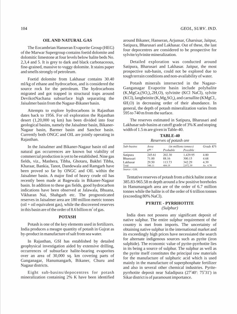
GEOL, SURV. IND.104
OIL AND NATURAL GAS
The Eocambrian Hanseran Evaporite Group (HEG) of the Marwar Supergroup contains foetid dolomite and dolomitic limestone at four levels below halite beds No. 2,3,4 and 5. It is grey to dark and black carbonaceous, fine-grained, massive to vuggy dolomite. It stains paper and smells strongly of petroleum.
Foetid dolomite from Lakhasar contains 30.40 ml/kg of ethane and hydrocarbon, and is considered the source rock for the petroleum. The hydrocarbons migrated and got trapped in structural traps around DevikotNachana subsurface high separating the Jaisalmer basin from the Nagaur-Bikaner basin.
Attempts to explore hydrocarbons in Rajasthan dates back to 1956. For oil exploration the Rajasthan desert (1,20,000 sq km) has been divided into four geological basins, namely the Jaisalmer basin, Bikaner-Nagaur basin, Barmer basin and Sanchor basin. Currently both ONGC and OIL are jointly operating in Rajasthan.
In the Jaisalmer and Bikaner-Nagaur basin oil and natural gas occurrences are known but viability of commercial production is yet to be established. Nine gas fields, viz., Manhera, Tibba, Ghotaru, Bakhri Tibba, Kharaar, Bankia, Tanot, Dandewala and Ramgarh have been proved so far by ONGC and OIL within the Jaisalmer basin. A major find of heavy crude oil has recently been made at Bagewala in Bikaner-Nagaur basin. In addition to these gas fields, good hydrocarbon indications have been observed at Jalawala, Bhuana, Vikharan Nai, Shahgarh etc. The prognosticated reserves in Jaisalmer area are 180 million metric tonnes (oil + oil equivalent gas), while the discovered reserves
3in this basin are of the order of 8.6 billion m of gas.
POTASH
Potash is one of the key elements used in fertilizers. India produces a meagre quantity of potash in Gujrat as by-product in manufacture of salt from sea water.
In Rajasthan, GSI has established by detailed geophysical investigation aided by extensive drilling, occurrences of subsurface halite-bearing evaporites over an area of 30,000 sq. km covering parts of Ganganagar, Hanumangarh, Bikaner, Churu and Nagaur districts.
Eight sub-basins/depocentres for potash mineralization containing 2% K have been identified
around Bikaner, Hanseran, Arjunsar, Gharsisar, Jaitpur, Satipura, Bharusari and Lakhasar. Out of these, the last four depocentres are considered to be prospective for sylvite/sylvinite mineralization.
Detailed exploration was conducted around Satipura, Bharusari and Lakhasar. Jaitpur, the most prospective sub-basin, could not be explored due to tough terrain conditions and non-availability of water.
Potash minerals intersected in the Nagaur-Ganganagar Evaporite basin include polyhalite (K MgCa (SO ) .2H O), sylvinite (KCl NaCl), sylvite 2 2 4 4 2
(KCl), langbeinite (K Mg SO ) and carnallite (KMgCl . 2 2 4 3 3
6H O) in decreasing order of their abundance. In 2
general, the depth of potash mineralization varies from 595 to 740 m from the surface.
The reserves estimated in Satipura, Bharusari and Lakhasar sub-basins at cutoff grade of 3% K and stoping width of 1.5 m are given in Table-40.
TABLE-40Reserves of potash ore
Source : GSI.
Tentative reserves of potash from a thick halite zone at 385.83-965.58 m depth around a few positive boreholes in Hanumangarh area are of the order of 6.7 million tonnes while the halite is of the order of 6 trillion tonnes (exceeding 80% NaCl).
PYRITE - PYRRHOTITE (Sulphur)
India does not possess any significant deposit of native sulphur. The entire sulphur requirement of the country is met from imports. The uncertainty of obtaining native sulphur in the international market and its exceedingly high prices have necessiated the search for alternate indigenous sources such as pyrite (iron sulphide). The economic value of pyrite-pyrrhotite lies in its being a source of sulphur. The sulphur as well as the pyrite itself constitutes the principal raw materials for the manufacture of sulphuric acid which is used mainly in the manufacture of superphosphate fertilizer and also in several other chemical industries. Pyrite-
o opyrrhotite deposit near Saladipura (27 40': 75 31') in Sikar district is of paramount importance.
MISC. PUB. No. 30 (12) 105
Sikar district
Saladipura pyrite-pyrrhotite deposit: The deposit, located about 1.5 km northwest of Saladipura, is approachable by a 30 km road from Kanwat railway station.
The deposit occurs along two shear zones in the rocks of the Ajabgarh Group of the Delhi Supergroup. It extends for a strike length of 7 km with thickness varying from 5 to 100 m, the average thickness being about 25 m. The deposit occurs 36-47 m below the surface and extends for more than 350 m in depth without any sign of bottoming. Within the main ore body, there are 2-3 subzones from 1 to 20 m, separated by leaner zones.
The main minerals in the ore body are pyrite and pyrrhotite with a minor amount of sphalerite, rare galena and chalcopyrite. The source for the sulphides appears to be the basic rocks occurring in the vicinity of the ore body. While the shear zones have served as channel-ways for the influx of the mineralizing solution. The sulphur content of the richer zones is 30-40%, while that of the leaner zones is 10-20%. The weighted average for the entire deposit has been worked out at 22.5% S. Besides sulphur, the ore also contains about 1% Zn. The total reserves of pyrite-pyrrhotite ore in this area have been estimated at 111.62 million tonnes containing, on an average, 21.63% S.
The ore at Saladipura is amenable to beneficiation so as to obtain the required concentrates having 35-40% S with good recovery of S. This deposit will provide the pyrite concentrates needed for manufacturing sulphuric acid in the fertilizer complex being set up in Rajasthan. The area has been handed over to Messrs Pyrites, Phosphates and Chemicals Ltd., a Government of India undertaking, for exploration.
ROCK PHOSPHATE
Rock phosphate, popularly known as phosphorite, is an essential ingredient in the manufacture of superphosphate, a fertilizer, whose paramount importance in boosting the green revolution in our country needs no emphasis.
The total reserves of rock phosphate known so far in India are about 175 million tonnes out of which 122 million tonnes are of low-grade containing 10-20% P O . Rajasthan contributes a major share in the 2 5
production of rock phosphate in India (Table -41).
In Rajasthan, phosphorites occur in diverse lithological formations ranging in age from Lower Proterozoic to Tertiary. Of these, the discovery of the Precambrian phosphorite in the Aravalli rocks of Udaipur district, in particular, has opened up new vistas in the sphere of exploration of rock phosphate in similar metasediments in India.
The phosphorite deposits in Udaipur and Banswara districts in Rajasthan are located within the rocks of the Aravalli Supergroup of Lower Proterozoic age while those of Alwar and Jaipur districts occur in the rocks of Delhi Supergroup of Lower to Middle Proterozoic age and that of the Chittaurgarh district occur in the rocks of the Lower Vindhyans of Middle Proterozoic age. Phosphorite occurrences are also reported from the Mesozoic Formations of Jaisalmer.
Udaipur district
The important phosphorite deposits located by the GSI are those of Maton, Kanpur, Karbaria-ka-Gurha and Dakan Kotra, all of which are located within a radius of 10-25 km from Udaipur. The largest deposit at Jhamar- Kotra discovered by DMGR is now being mined.
o oJhamar Kotra (24 40': 75 52') deposit: This is the largest and richest phosphorite deposit proved so far in the country. The Jhamar Kotra deposit is located about 26 km southeast of Udaipur. The phosphorite horizon extends over a strike length of about 12-15 km with thickness varying from 5 to 30 m. The phosphorite is associated with algal limestone and chetry quartzite. The reserves in the entire area down to a depth of 30 m, according to the DMGR, are of the order of 40 million tonnes, of which about 10.5 million tonnes contain phosphorite having 30-37% P O . The rest of 2 5
phosphorite contain about 20-30% P O . The deposit is 2 5
under exploitation by the DMGR.o oMaton deposit: The Maton (24 33': 73 47') deposit
is located about 13 km east of Udaipur. The bluish grey, phosphorite horizon 0.5-20 m thick in this area,
TABLE-41Production of rock phosphate in India vs Rajasthan
Source : DMGR, 1997. Bull. 18, Vol. 1
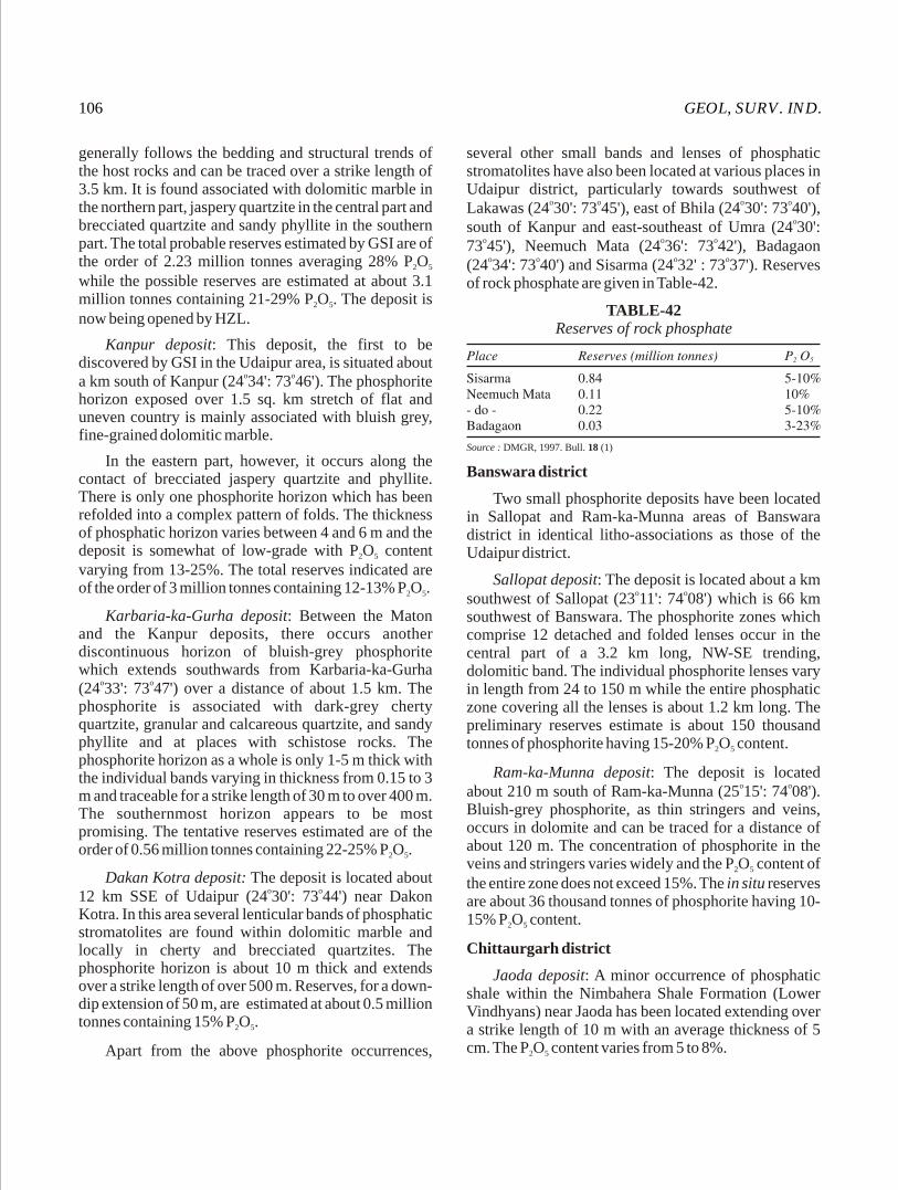
GEOL, SURV. IND.106
generally follows the bedding and structural trends of the host rocks and can be traced over a strike length of 3.5 km. It is found associated with dolomitic marble in the northern part, jaspery quartzite in the central part and brecciated quartzite and sandy phyllite in the southern part. The total probable reserves estimated by GSI are of the order of 2.23 million tonnes averaging 28% P O 2 5
while the possible reserves are estimated at about 3.1 million tonnes containing 21-29% P O . The deposit is 2 5
now being opened by HZL.
Kanpur deposit: This deposit, the first to be discovered by GSI in the Udaipur area, is situated about
o oa km south of Kanpur (24 34': 73 46'). The phosphorite horizon exposed over 1.5 sq. km stretch of flat and uneven country is mainly associated with bluish grey, fine-grained dolomitic marble.
In the eastern part, however, it occurs along the contact of brecciated jaspery quartzite and phyllite. There is only one phosphorite horizon which has been refolded into a complex pattern of folds. The thickness of phosphatic horizon varies between 4 and 6 m and the deposit is somewhat of low-grade with P O content 2 5
varying from 13-25%. The total reserves indicated are of the order of 3 million tonnes containing 12-13% P O .2 5
Karbaria-ka-Gurha deposit: Between the Maton and the Kanpur deposits, there occurs another discontinuous horizon of bluish-grey phosphorite which extends southwards from Karbaria-ka-Gurha
o o(24 33': 73 47') over a distance of about 1.5 km. The phosphorite is associated with dark-grey cherty quartzite, granular and calcareous quartzite, and sandy phyllite and at places with schistose rocks. The phosphorite horizon as a whole is only 1-5 m thick with the individual bands varying in thickness from 0.15 to 3 m and traceable for a strike length of 30 m to over 400 m. The southernmost horizon appears to be most promising. The tentative reserves estimated are of the order of 0.56 million tonnes containing 22-25% P O .2 5
Dakan Kotra deposit: The deposit is located about o o12 km SSE of Udaipur (24 30': 73 44') near Dakon
Kotra. In this area several lenticular bands of phosphatic stromatolites are found within dolomitic marble and locally in cherty and brecciated quartzites. The phosphorite horizon is about 10 m thick and extends over a strike length of over 500 m. Reserves, for a down-dip extension of 50 m, are estimated at about 0.5 million tonnes containing 15% P O .2 5
Apart from the above phosphorite occurrences,
several other small bands and lenses of phosphatic stromatolites have also been located at various places in Udaipur district, particularly towards southwest of
o o o oLakawas (24 30': 73 45'), east of Bhila (24 30': 73 40'), osouth of Kanpur and east-southeast of Umra (24 30':
o o o73 45'), Neemuch Mata (24 36': 73 42'), Badagaon o o o o(24 34': 73 40') and Sisarma (24 32' : 73 37'). Reserves
of rock phosphate are given in Table-42.
TABLE-42Reserves of rock phosphate
Source : DMGR, 1997. Bull. 18 (1)
Banswara district
Two small phosphorite deposits have been located in Sallopat and Ram-ka-Munna areas of Banswara district in identical litho-associations as those of the Udaipur district.
Sallopat deposit: The deposit is located about a km o osouthwest of Sallopat (23 11': 74 08') which is 66 km
southwest of Banswara. The phosphorite zones which comprise 12 detached and folded lenses occur in the central part of a 3.2 km long, NW-SE trending, dolomitic band. The individual phosphorite lenses vary in length from 24 to 150 m while the entire phosphatic zone covering all the lenses is about 1.2 km long. The preliminary reserves estimate is about 150 thousand tonnes of phosphorite having 15-20% P O content.2 5
Ram-ka-Munna deposit: The deposit is located o oabout 210 m south of Ram-ka-Munna (25 15': 74 08').
Bluish-grey phosphorite, as thin stringers and veins, occurs in dolomite and can be traced for a distance of about 120 m. The concentration of phosphorite in the veins and stringers varies widely and the P O content of 2 5
the entire zone does not exceed 15%. The in situ reserves are about 36 thousand tonnes of phosphorite having 10-15% P O content.2 5
Chittaurgarh district
Jaoda deposit: A minor occurrence of phosphatic shale within the Nimbahera Shale Formation (Lower Vindhyans) near Jaoda has been located extending over a strike length of 10 m with an average thickness of 5 cm. The P O content varies from 5 to 8%.2 5
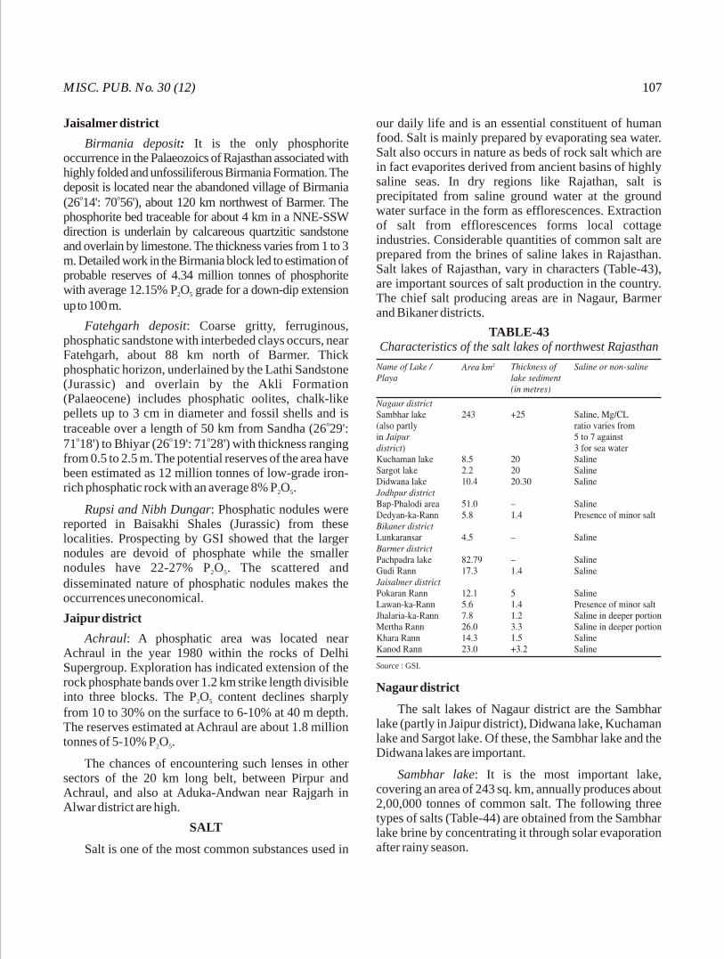
MISC. PUB. No. 30 (12) 107
Jaisalmer district
Birmania deposit: It is the only phosphorite occurrence in the Palaeozoics of Rajasthan associated with highly folded and unfossiliferous Birmania Formation. The deposit is located near the abandoned village of Birmania
o o(26 14': 70 56'), about 120 km northwest of Barmer. The phosphorite bed traceable for about 4 km in a NNE-SSW direction is underlain by calcareous quartzitic sandstone and overlain by limestone. The thickness varies from 1 to 3 m. Detailed work in the Birmania block led to estimation of probable reserves of 4.34 million tonnes of phosphorite with average 12.15% P O grade for a down-dip extension 2 5
up to 100 m.
Fatehgarh deposit: Coarse gritty, ferruginous, phosphatic sandstone with interbeded clays occurs, near Fatehgarh, about 88 km north of Barmer. Thick phosphatic horizon, underlained by the Lathi Sandstone (Jurassic) and overlain by the Akli Formation (Palaeocene) includes phosphatic oolites, chalk-like pellets up to 3 cm in diameter and fossil shells and is
otraceable over a length of 50 km from Sandha (26 29': o o o71 18') to Bhiyar (26 19': 71 28') with thickness ranging
from 0.5 to 2.5 m. The potential reserves of the area have been estimated as 12 million tonnes of low-grade iron-rich phosphatic rock with an average 8% P O .2 5
Rupsi and Nibh Dungar: Phosphatic nodules were reported in Baisakhi Shales (Jurassic) from these localities. Prospecting by GSI showed that the larger nodules are devoid of phosphate while the smaller nodules have 22-27% P O . The scattered and 2 5
disseminated nature of phosphatic nodules makes the occurrences uneconomical.
Jaipur district
Achraul: A phosphatic area was located near Achraul in the year 1980 within the rocks of Delhi Supergroup. Exploration has indicated extension of the rock phosphate bands over 1.2 km strike length divisible into three blocks. The P O content declines sharply 2 5
from 10 to 30% on the surface to 6-10% at 40 m depth. The reserves estimated at Achraul are about 1.8 million tonnes of 5-10% P O .2 5
The chances of encountering such lenses in other sectors of the 20 km long belt, between Pirpur and Achraul, and also at Aduka-Andwan near Rajgarh in Alwar district are high.
SALT
Salt is one of the most common substances used in
our daily life and is an essential constituent of human food. Salt is mainly prepared by evaporating sea water. Salt also occurs in nature as beds of rock salt which are in fact evaporites derived from ancient basins of highly saline seas. In dry regions like Rajathan, salt is precipitated from saline ground water at the ground water surface in the form as efflorescences. Extraction of salt from efflorescences forms local cottage industries. Considerable quantities of common salt are prepared from the brines of saline lakes in Rajasthan. Salt lakes of Rajasthan, vary in characters (Table-43), are important sources of salt production in the country. The chief salt producing areas are in Nagaur, Barmer and Bikaner districts.
Source : GSI.
TABLE-43Characteristics of the salt lakes of northwest Rajasthan
Nagaur district
The salt lakes of Nagaur district are the Sambhar lake (partly in Jaipur district), Didwana lake, Kuchaman lake and Sargot lake. Of these, the Sambhar lake and the Didwana lakes are important.
Sambhar lake: It is the most important lake, covering an area of 243 sq. km, annually produces about 2,00,000 tonnes of common salt. The following three types of salts (Table-44) are obtained from the Sambhar lake brine by concentrating it through solar evaporation after rainy season.
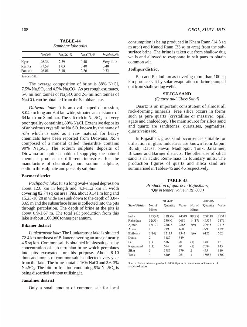
GEOL, SURV. IND.108
consumption is being produced in Khara Rann (14.3 sq m area) and Kanod Rann (23 sq m area) from the sub-
surface brine. The brine is taken out from shallow dug wells and allowed to evaporate in salt pans to obtain common salt.
Jodhpur district
Bap and Phalodi areas covering more than 100 sq km produce salt by solar evaporation of brine pumped out from shallow dug wells.
SILICA SAND(Quartz and Glass Sand)
Quartz is an important constitutent of almost all rock-forming minerals. Free silica occurs in forms such as pure quartz (crystalline or massive), opal, agate and chalcedony. The main source for silica sand and quartz are sandstones, quartzites, pegmatites, quartz veins etc.
In Rajasthan, glass sand occurrences suitable for utilisation in glass industries are known from Jaipur, Bundi, Dausa, Sawai Madhopur, Tonk, Jaisalmer, Bikaner and Barmer districts. The other use of silica sand is in acidic Remi-mass in foundary units. The production figures of quartz and silica sand are summarised in Tables-45 and 46 respectively.
TABLE-44Sambhar lake salts
Source : GSI.
The average composition of brine is 88% NaCl, 7.5% Na SO and 4.5% Na CO . As per rough estimates, 2 4 2 3
5-6 million tonnes of Na SO and 2-3 million tonnes of 2 4
Na CO can be obtained from the Sambhar lake.2 3
Didwana lake: It is an oval-shaped depression, 8.04 km long and 6.4 km wide, situated at a distance of 64 km from Sambhar. The salt rich in Na SO is of very 2 4
poor quality containing 80% NaCl. Extensive deposits of anhydrous crystalline Na SO known by the name of 2 4
rohi which is used as a raw material for heavy chemicals have been reported from Didwana. Rohi composed of a mineral called 'thenardite' contains 90% Na SO . The sodium sulphate deposits of 2 4
Didwana are quite capable of supplying the natural chemical product to different industries for the manufacture of chemically pure sodium sulphate, sodium thiosulphate and possibly sulphur.
Barmer district
Pachpadra lake: It is a long oval-shaped depression about 12.8 km in length and 4.3-11.2 km in width covering 82.74 sq km area. Pits, about 91.41 m long and 15.23-18.28 m wide are sunk down to the depth of 3.04-3.65 m and the subsurface brine is collected into the pits through percolation. The depth of brine at the pits is about 0.9-1.67 m. The total salt production from this lake is about 1,00,000 tonnes per annum.
Bikaner district
Lunkaransar lake: The Lunkaransar lake is situated 72.4 km northeast of Bikaner covering an area of nearly 4.5 sq km. Common salt is obtained in pits/salt pans by concentration of sub-terranian brine which percolates into pits excavated for this purpose. About 8-10 thousand tonnes of common salt is collected every year from this lake. The brine contains 16% NaCl and 2.6-3% Na SO . The bittern fraction containing 9% Na SO is 2 4 2 4
being discarded without utilising it.
Jaisalmer district
Only a small amount of common salt for local
TABLE-45Production of quartz in Rajasthan;
(Qty in tonnes, value in Rs '000 )
Source: Indian minerals yearbook, 2006; figures in parentheses indicate nos. of associated mines.
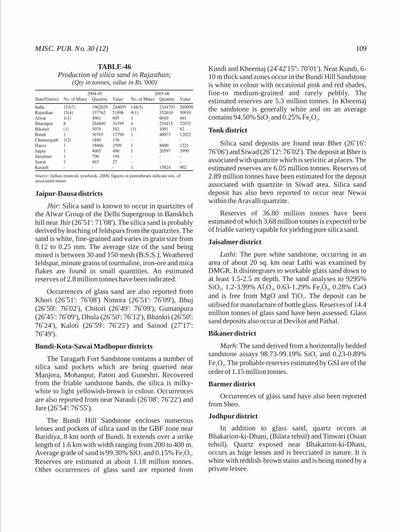
MISC. PUB. No. 30 (12) 109
Jaipur-Dausa districts
Jhir: Silica sand is known to occur in quartzites of the Alwar Group of the Delhi Supergroup in Banskhch
o ohill near Jhir (26 51': 71 08'). The silica sand is probably derived by leaching of feldspars from the quartzites. The sand is white, fine-grained and varies in grain size from 0.12 to 0.25 mm. The average size of the sand being mined is between 30 and 150 mesh (B.S.S.). Weathered feldspar, minute grains of tourmaline, iron-ore and mica flakes are found in small quantities. An estimated reserves of 2.8 million tonnes have been indicated.
Occurrences of glass sand are also reported from o o o oKhori (26 51': 76 08') Nimora (26 51': 76 09'), Bhuj
o o o o(26 59': 76 02'), Chitori (26 49': 76 09'), Gumanpura o o o o o(26 45': 76 09'), Dhula (26 50': 76 12'), Bhankri (26 50':
o o o o76 24'), Kaloti (26 59': 76 25') and Sainod (27 17': o76 49').
Bundi-Kota-Sawai Madhopur districts
The Taragarh Fort Sandstone contains a number of silica sand pockets which are being quarried near Manjora, Mohanpur, Patori and Guneshri. Recovered from the friable sandstone bands, the silica is milky-white to light yellowish-brown in colour. Occurrences
o oare also reported from near Narauli (26 08': 76 22') and o oJare (26 54': 76 55').
The Bundi Hill Sandstone encloses numerous lenses and pockets of silica sand in the GBF zone near Baridiya, 8 km north of Bundi. It extends over a strike length of 1.6 km with width ranging from 200 to 400 m. Average grade of sand is 99.30% SiO and 0.15% Fe O . 2 2 3
Reserves are estimated at about 1.18 million tonnes. Other occurrences of glass sand are reported from
o oKundi and Kheemaj (24 42'15'': 70 01'). Near Kundi, 6-10 m thick sand zones occur in the Bundi Hill Sandstone is white in colour with occasional pink and red shades, fine-to medium-grained and rarely pebbly. The estimated reserves are 5.3 million tonnes. In Kheemaj the sandstone is generally white and on an average contains 94.50% SiO and 0.25% Fe O . 2 2 3
Tonk district
oSilica sand deposits are found near Bher (26 16': o o o76 06') and Siwad (26 12': 76 02'). The deposit at Bher is
associated with quartzite which is sericitic at places. The estimated reserves are 6.05 million tonnes. Reserves of 2.89 million tonnes have been estimated for the deposit associated with quartzite in Siwad area. Silica sand deposit has also been reported to occur near Newai within the Aravalli quartzite.
Reserves of 36.80 million tonnes have been estimated of which 3.68 million tonnes is expected to be of friable variety capable for yielding pure silica sand.
Jaisalmer district
Lathi: The pure white sandstone, occurring in an area of about 20 sq. km near Lathi was examined by DMGR. It disintegrates to workable glass sand down to at least 1.5-2.5 m depth. The sand analyses to 9295% SiO , 1.2-3.99% Al O , 0.63-1.29% Fe O , 0.28% CaO 2 2 3 2 3
and is free from MgO and TiO . The deposit can be 2
utilised for manufacture of bottle glass. Reserves of 14.4 million tonnes of glass sand have been assessed. Glass sand deposits also occur at Devikot and Pathal.
Bikaner district
Marh: The sand derived from a horizontally bedded sandstone assays 98.73-99.19% SiO and 0.23-0.89% 2
Fe O . The probable reserves estimated by GSI are of the 2 3
order of 1.15 million tonnes.
Barmer district
Occurrences of glass sand have also been reported from Sheo.
Jodhpur district
In addition to glass sand, quartz occurs at Bhakarion-ki-Dhani, (Bilara tehsil) and Tinwari (Osian tehsil). Quartz exposed near Bhakarion-ki-Dhani, occurs as huge lenses and is brecciated in nature. It is white with reddish-brown stains and is being mined by a private lessee.
TABLE-46Production of silica sand in Rajasthan;
(Qty in tonnes, value in Rs '000)
Source: Indian minerals yearbook, 2006; figures in parentheses indicate nos. of associated mines.

GEOL, SURV. IND.110
SILVER
Silver is valued as a medium of exchange and also for its use in jewellery. In recent years, its application in industry has increased rapidly. In India, silver is obtained as by-product of Pb-Zn and Au mining. Reserves of silver as on 01.04.2005 and production of silver during 2003-04, 2004-05 and 2005-06 years are given in Table-47A & 48 respectively. Recoverable reserve of silver is shown in Table-47.
tetrahedrite, tennantite and pyrargyrite in the Dariba Main and Dariba East lodes in the Rajpura-Dariba base metal area prospect. Borehole samples from this area have analysed 100-2,000 ppm of Ag. Further, the Pb-Cu concentrates containing 24.6% Cu and 63.49% Pb (with recoveries of 70.5% Cu and 92.2% Pb) were assayed and found that Cu concentrates assayed 766 gm of Ag per tonne. This indicates that silver could be recovered from the base metal ores as an important and valuable by-product. Even assuming 90 gm per tonne as the average Ag content of the ores, the Rajpura-Dariba deposit is likely to yield about 2,250 tonnes of Ag in the proved and probable reserves and additional 2,430 tonnes in the possible reserves.
Bhilwara district
Small reserves of silver have been established at o oSouth Dedwas and Bharak (25 08': 74 16'). At Bharak,
22,579 tonnes of possible reserves of Ag, of 670 ppm grade with 150 ppm Ag cutoff, over a strike length of 200 m within siliceous dolomite, marble and metamarl have been estimated.
SILICEOUS EARTH
Siliceous earth composed mainly of colloidal silica and other siliceous matters contains chiefly 69-81% SiO and 4-12% Al O with very little CaO, MgO and 2 2 3
iron oxides. It is homogeneous, porous, easily breakable and light in weight. It has high absorption power. Its main use is as filters and refractory silica-bricks. Siliceous earth occurrences are known from Barmer and Jaisalmer districts.
Barmer-Jaisalmer districts
Siliceous earth occurs as two thin beds, grading laterally and vertically into bentonite at Dharivi Khurd, Mandai, Akli and Sajeet Nimla. These beds vary in thickness from 0.15 to 1.45 m. The siliceous earth contains silica (up to 80%) and is suitable for filters and manufacture of refractory silica bricks. The total estimated reserves of siliceous earth in the area, falling partly in Jaisalmer district and partly in Barmer district, are about 10 million tonnes of which 1.2 million tonnes have been assessed in Jaisalmer area.
Siliceous earth deposits are also known from Matti-ka-Gol (0.33 million tonnes with 74.32% SiO ), 2
Bhorasar (0.66 million tonnes with 74.40% SiO ), Jatto-2
ki-Dhani (0.35 million tonnes with 72.0% SiO ) and 2
Bariyara (0.10 million tonnes with 76.28% SiO ).2
In Rajasthan silver is associated with the Pb-Zn ores of Zawar, Rajpura-Dariba and Bharak areas of Udaipur, Rajsamand and Bhilwara districts respectively and is extracted during the smelting of Pb from the Pb concentrates.
Udaipur districto oZawar area (24 17': 73 41'): The ore reserves
estimated so far in the Mochia, Balaria and Zawarmala sections of the Zawar Pb-Zn belt are of the order of 27 million tonnes containing on an average 4% Zn and 1.5% Pb. Thus the Zawar deposit is likely to yield 4,05,000 tonnes of Pb. The average silver recovery being about 1 kg per tonne of Pb concentrate; a total of 405 tonnes of Ag is expected from the Zawar area, as per the estimates of the HZL.
Rajsamand districto o o oRajpura-Dariba area (24 57': 74 08'24 58': 74 08')
: Silver is often found to be associated with galena,
TABLE-47Recoverable reserves of silver
Source : Indian Minerals Year Book 1996 Vol. 2, 1998, p. 580.
TABLE-47AReserve of silver as on 01-04-2005; (Ores in million tonnes)
Source: Indian minerals yearbook, 2006
TABLE-48Production of silver; (Qty in kg; value in Rs '000)
Source: Indian minerals yearbook, 2006

MISC. PUB. No. 30 (12) 111
STEATITE
Steatite, talc and soapstone are the three terms used in trade for a hydrous silicate of magnesium. A purer variety of compact and massive talc is steatite.
Rajasthan is the prime producer of soapstone in India. Rajasthan with 6.3 million tonnes of reserves accounts for about 41% of the all India total reserves of all categories. It produces about 86% of the national output. Occurrences of soapstone have been reported from Jaipur, Bhilwara, Dausa, Sawai Madhopur, Udaipur, Dungarpur and Banswara districts.
Jaipur-Dausa districts
Prominent deposits are located at Dogetha-Jharna o o o o(27 07': 76 16') and Geejgarh (26 50': 76 35'). The
Dogetha-Jharara deposit is associated with dolomites and basic intrusives of the Raialo Group of the Delhi Supergroup. The talc occurs as veins with concentrated pockets of massive variety in three-paralled zones and varies in thickness from 1 to 6 m. Inferred reserves of 0.25 million tonnes have been indicated in the area.
Bhilwara districtoProminent deposits are located at Geuria (26 26':
o o o75 03') and Chainpura (25 28': 75 06'). Occurrences are o oalso reported from Bhanai Khera (25 26': 75 04').
In Geuria and Chainpura, talc is confined to the dolomite of the Jahajpur Group of the Bhilwara Supergroup. The talc lenses vary in thickness from 1 to 21 m and are generaly white in colour. The inferred reserves of the deposits are 0.42 million tonnes.
Sawai Madhopur district
Talc deposits have been reported from Dhaota o o o o(26 48': 76 44'), Dwain (26 48': 76 45'), Kamalpura o o o o o(26 48' : 76 46'), Rajauli (26 48': 76 48'), Garhi (26 48':
o o o o o76 47'), Pura (26 48': 76 48') and Morra (26 48': 76 48'). Talc in these deposits occurs in quartzite as veins and lenses varying in thickness from 0.5 to 20 m. Talc, cleaved and foliated, is generally pale green to greenish-white in colour. Reserves of 0.01 million tonnes have been estimated from these deposits.
Udaipur-Dungarpur districts
Talc deposits/occurrences are associated with the Rakhabdev ultrabasic belt. The important deposits/
o ooccurrences of talc are from Undithal (24 35': 73 29'), o o oRathor-ka-Gurha (24 43': 73 34'), Bansra (24 44' :
o o o o o73 35'), Ord (24 22': 73 47'), Deopura (24 18': 73 47'), o o o oPadla (24 19': 73 46'), Parsola (23 57': 74 23'),
o o oBhungapat (23 56': 74 21'), Bharkhundi (23 58': o o o o o78 19'), Gurali (24 38': 73 48'), Negria (24 43': 73 48')
o oand Nathanwas (24 55': 73 50'). Pyrophyllite is o oavailable at Naya Garhu (24 34': 73 37'), Gorach
o o o o o(24 48': 73 40'), Sonairo (24 44': 73 41'), Bari (24 36': o o o73 38'), Brahman-ka-Varla (24 39': 73 37') and Rama
o o(24 44': 73 41').
Talc and pyrophyllite are generally pale green to greenish-white, cleaved and foliated. An indicated reserves of 0.05 million tonnes of talc have been esti-mated from these deposits. The reserves of pyrophyllite deposits are estimated at 0.22 million tonnes.
TIN
Tin is recovered from its oxide cassiterite. Metal tin is widely used in alloys and in the chemical industry. Tin oxide is used as polishing material for marble and granite. India does not possess workable deposits of tin and the entire requirement is met by imports. In Rajasthan, Bhilwara district holds some promise of holding a deposit.
Bhilwara district
oTin ores are known to occur in Paroli (25 15': o74 55') area which has been examined by the IBM, and
found to be fairly promising.
In Johna Sili area, tin-bearing lodes have been proved over a distance of 1.6 km along the strike and for 12-19 m in depth along the dip direction. The lodes, irregular in shape and size, have assayed on an average 0.25% tin metal.
TUNGSTEN
Tungsten is a metal of strategic importance. It is used in the manufacture of high-speed alloy and special steels, and is essential for machine tools, armour plates and other military equipment. It is also used in various electrical appliances. Tungsten carbide, much harder than the hardest steel, is used in making drill bits, cutting tools etc.
In India the occurrences of tungsten ore (wolframite) are few. The best known deposit of the
o ocountry is that of Degana (26 50': 74 20') in Rajasthan. The total reserves vis-a-vis production of tugnsten in India and Rajasthan in recent years are summarised in Tables-49 and 50.
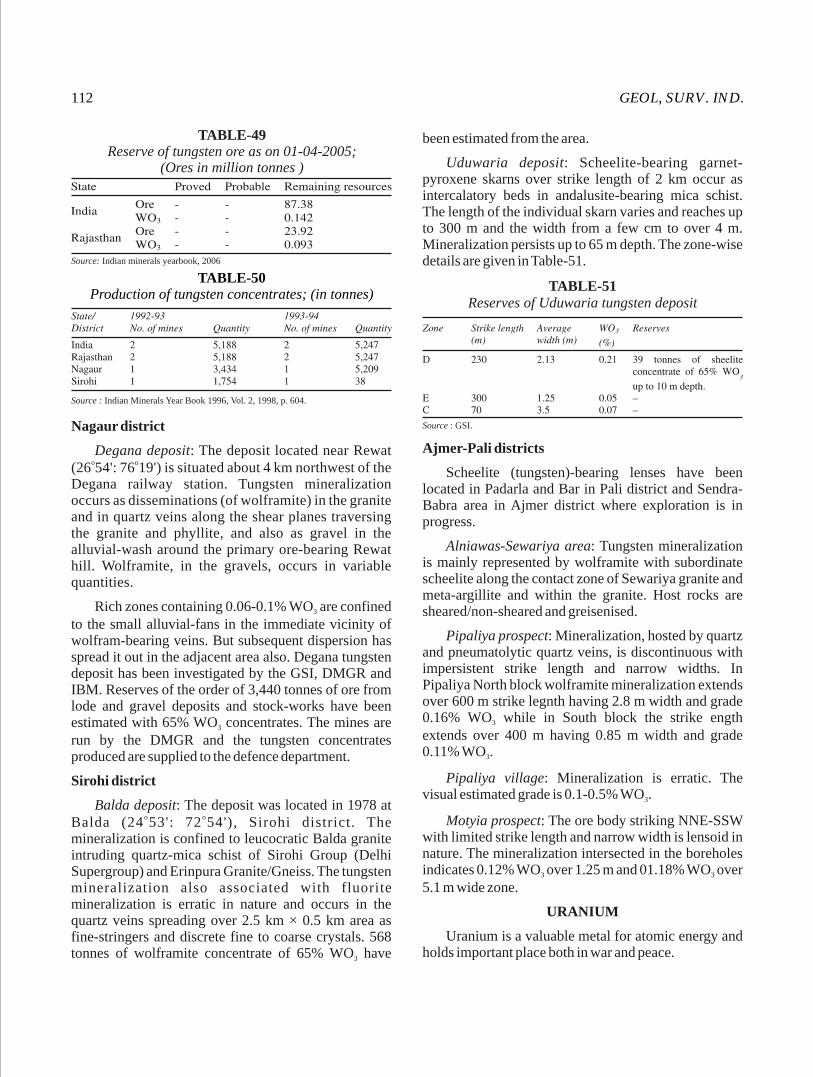
GEOL, SURV. IND.112
Nagaur district
Degana deposit: The deposit located near Rewat o o(26 54': 76 19') is situated about 4 km northwest of the
Degana railway station. Tungsten mineralization occurs as disseminations (of wolframite) in the granite and in quartz veins along the shear planes traversing the granite and phyllite, and also as gravel in the alluvial-wash around the primary ore-bearing Rewat hill. Wolframite, in the gravels, occurs in variable quantities.
Rich zones containing 0.06-0.1% WO are confined 3
to the small alluvial-fans in the immediate vicinity of wolfram-bearing veins. But subsequent dispersion has spread it out in the adjacent area also. Degana tungsten deposit has been investigated by the GSI, DMGR and IBM. Reserves of the order of 3,440 tonnes of ore from lode and gravel deposits and stock-works have been estimated with 65% WO concentrates. The mines are 3
run by the DMGR and the tungsten concentrates produced are supplied to the defence department.
Sirohi district
Balda deposit: The deposit was located in 1978 at o oBalda (24 53': 72 54'), Sirohi district. The
mineralization is confined to leucocratic Balda granite intruding quartz-mica schist of Sirohi Group (Delhi Supergroup) and Erinpura Granite/Gneiss. The tungsten mineralization also associated with fluorite mineralization is erratic in nature and occurs in the quartz veins spreading over 2.5 km × 0.5 km area as fine-stringers and discrete fine to coarse crystals. 568 tonnes of wolframite concentrate of 65% WO have 3
been estimated from the area.
Uduwaria deposit: Scheelite-bearing garnet-pyroxene skarns over strike length of 2 km occur as intercalatory beds in andalusite-bearing mica schist. The length of the individual skarn varies and reaches up to 300 m and the width from a few cm to over 4 m. Mineralization persists up to 65 m depth. The zone-wise details are given in Table-51.
TABLE-49Reserve of tungsten ore as on 01-04-2005;
(Ores in million tonnes )
Source: Indian minerals yearbook, 2006
TABLE-50Production of tungsten concentrates; (in tonnes)
Source : Indian Minerals Year Book 1996, Vol. 2, 1998, p. 604.
TABLE-51Reserves of Uduwaria tungsten deposit
Source : GSI.
Ajmer-Pali districts
Scheelite (tungsten)-bearing lenses have been located in Padarla and Bar in Pali district and Sendra-Babra area in Ajmer district where exploration is in progress.
Alniawas-Sewariya area: Tungsten mineralization is mainly represented by wolframite with subordinate scheelite along the contact zone of Sewariya granite and meta-argillite and within the granite. Host rocks are sheared/non-sheared and greisenised.
Pipaliya prospect: Mineralization, hosted by quartz and pneumatolytic quartz veins, is discontinuous with impersistent strike length and narrow widths. In Pipaliya North block wolframite mineralization extends over 600 m strike legnth having 2.8 m width and grade 0.16% WO while in South block the strike ength 3
extends over 400 m having 0.85 m width and grade 0.11% WO . 3
Pipaliya village: Mineralization is erratic. The visual estimated grade is 0.1-0.5% WO . 3
Motyia prospect: The ore body striking NNE-SSW with limited strike length and narrow width is lensoid in nature. The mineralization intersected in the boreholes indicates 0.12% WO over 1.25 m and 01.18% WO over 3 3
5.1 m wide zone.
URANIUM
Uranium is a valuable metal for atomic energy and holds important place both in war and peace.
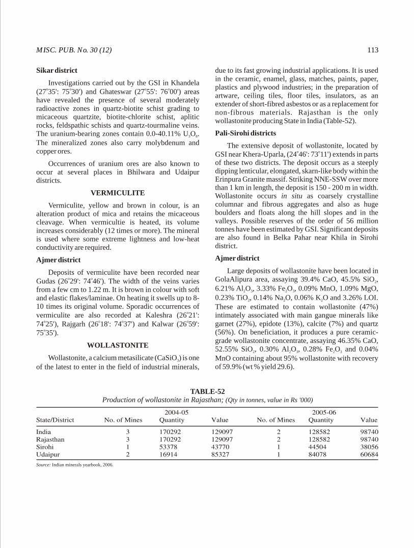
MISC. PUB. No. 30 (12) 113
Sikar district
Investigations carried out by the GSI in Khandela o o o o(27 35': 75 30') and Ghateswar (27 55': 76 00') areas
have revealed the presence of several moderately radioactive zones in quartz-biotite schist grading to micaceous quartzite, biotite-chlorite schist, aplitic rocks, feldspathic schists and quartz-tourmaline veins. The uranium-bearing zones contain 0.0-40.11% U O . 3 8
The mineralized zones also carry molybdenum and copper ores.
Occurrences of uranium ores are also known to occur at several places in Bhilwara and Udaipur districts.
VERMICULITE
Vermiculite, yellow and brown in colour, is an alteration product of mica and retains the micaceous cleavage. When vermicultie is heated, its volume increases considerably (12 times or more). The mineral is used where some extreme lightness and low-heat conductivity are required.
Ajmer district
Deposits of vermiculite have been recorded near o oGudas (26 29': 74 46'). The width of the veins varies
from a few cm to 1.22 m. It is brown in colour with soft and elastic flakes/laminae. On heating it swells up to 8-10 times its original volume. Sporadic occurrences of
overmiculite are also recorded at Kaleshra (26 21': o o o o74 25'), Rajgarh (26 18': 74 37') and Kalwar (26 59': o75 35').
WOLLASTONITE
Wollastonite, a calcium metasilicate (CaSiO ) is one 3
of the latest to enter in the field of industrial minerals,
due to its fast growing industrial applications. It is used in the ceramic, enamel, glass, matches, paints, paper, plastics and plywood industries; in the preparation of artware, ceiling tiles, floor tiles, insulators, as an extender of short-fibred asbestos or as a replacement for non-fibrous materials. Rajasthan is the only wollastonite producing State in India (Table-52).
Pali-Sirohi districts
The extensive deposit of wollastonite, located by o oGSI near Khera-Uparla, (24 46': 73 11') extends in parts
of these two districts. The deposit occurs as a steeply dipping lenticular, elongated, skarn-like body within the Erinpura Granite massif. Striking NNE-SSW over more than 1 km in length, the deposit is 150 - 200 m in width. Wollastonite occurs in situ as coarsely crystalline columnar and fibrous aggregates and also as huge boulders and floats along the hill slopes and in the valleys. Possible reserves of the order of 56 million tonnes have been estimated by GSI. Significant deposits are also found in Belka Pahar near Khila in Sirohi district.
Ajmer district
Large deposits of wollastonite have been located in GolaAlipura area, assaying 39.4% CaO, 45.5% SiO , 2
6.21% Al O , 3.33% Fe O , 0.09% MnO, 1.09% MgO, 2 3 2 3
0.23% TiO , 0.14% Na O, 0.06% K O and 3.26% LOI. 2 2 2
These are estimated to contain wollastonite (47%) intimately associated with main gangue minerals like garnet (27%), epidote (13%), calcite (7%) and quartz (56%). On beneficiation, it produces a pure ceramic-grade wollastonite concentrate, assaying 46.35% CaO, 52.55% SiO , 0.30% Al O , 0.28% Fe O and 0.04% 2 2 3 2 3
MnO containing about 95% wollastonite with recovery of 59.9% (wt % yield 29.6).
TABLE-52Production of wollastonite in Rajasthan; (Qty in tonnes, value in Rs '000)
Source: Indian minerals yearbook, 2006.

GEOL, SURV. IND.114
Nim ka Thana Copper Belt
Copper mineralisation in Nim ka Thana belt is mainly located in Baniwal ki Dhani and Dokan areas of Sikar district, Rajasthan. Nim ka Thana copper belt is about 20 km long starting from Nimod in the south to Mina ka Nangal in the north and further extending upto Gangutana in Haryana.
The Alwar and Ajabgarh Group of rocks belonging to the Delhi Supergroup of palaeo to meso-Proterozoic age represent the mineral belt. Quartzite, mica schist and quartz mica schist constitute the Alwar Group. The Ajabgarh Group is represented by the Kushalgarh Formation consisting of mica +/- garnet schist and quartzite. These rocks are intruded by pegmatite, quartz vein, albitite, amphibolite and granite.
The host rock for copper mineralisation is amphibole/impure marble and calcareous biotite amphibole schist of Kushalgarh Formation. The mineralisation occurs as lensoid bodies with varying width. Copper ore minerals are bornite, covellite, chalcopyrite and chalcocite occurring as fine disseminated specks, stringers and veins along foliation and fracture planes.
Total ore reserves estimated so far in this belt is about 85.26 MT containing an average grade of 0.3% Cu with minor amount of Ag.
Dariba-Bethumbi-Surawas lead-zinc Belt
Dariba- Bethumbi-Surawas lead-zinc belt is located in Rajsamand district, Rajasthan. It contains most potential lead-zinc deposits in India. The belt is 19 km long extending from Dariba in the south to Surawas in the north where it is dislocated by a ENE-WSW cross fault and further continue in a narrow strip up to Bharak river (Bhilwara District). Famous Rajpura gossan is located in the southern part of this belt.
The area comprises cover rock sequences consisting of meta-volcano-sedimentary rocks of Rajpura-Dariba Group occurring in the gneisses of the Mangalwar Complex, a part of the Bhilwara Supergroup of Archean-PalaeoProterozoic age. The cover rocks are represented by carbonaceous schist, interbanded schist and cherty quartzite, tuffaceous schist with or without garnet, staurolite and kyanite, calcareous schist, calc silicate marble /dolomite, laminated bands of marble and schist (meta-marl), meta-psammites with quartzite and amphibolite and conglomerate. The lithounits show lateral facies variation and are intruded by quartz veins and dolerite dykes. The Mangalwar rocks comprise psammitic gneisses and quartzo-feldspathic rock. The basement of cover rock sequence is uneven showing basement highs and lows.
The area exhibits three phases of deformation. The folds of first two generation are coaxially folded with NNE-SSW fold axis. The third phase has given rise cross folds with WNW-ESE axis forming culmination and depression structures over earlier folds and produce arcuate shaped outcrop pattern of the belt. Carbonaceous schist, calcareous schist and marble/dolomite are the best rocks for lead-zinc mineralisation. Calc silicate marble/dolomite contains high grade ores. The primary host rock appears to be schist where lead-zinc ores occur as fine grained specks and thin layers and in calc silicate marble they occur as coarse grained specks, stringers, veins and pseudo-breccia. It appears that the fine grained ores were remobilized during deformation and metamorphism. The remobilized ores were concentrated at favorable locales and replaced the carbonates constituting ore zones. The main lead-zinc minerals are galena and sphalerite. Other sulphides are pyrite and pyrrhotite. Besides these, other ore minerals are tennantite, tetrahedrite, chalcopyrite and geochronite.
A total of 320 MT ore reserve has been estimated in Dariba-Bethumbi-Surawas belt containing average grade 2% to 8% Pb + Zn associated with Cd and Ag. Out of this, about 70 MT of ore reserve is established within calc silicate marble/dolomite with an average grade 6% to 8% Pb + Zn.
Bhukia Gold Belt
Bhuikia gold belt, Banswara district, Rajasthan, is located northeast of Banswara in southeastern Rajasthan. It forms a part of Proterozoic supracrustals of the Aravalli Supergroup representing a metamorphosed volcano-sedimentary sequence within the northwestern Precambrian craton and occupies an area of about 5.5 sq. km.
Muscovite-biotite-quartz schist, dolomitic marble, keratophyre, actinolite-quartzite and amphibolite/meta-pyroxenite are the major lithounits exposed in the area and together constitute a separate lithopackage which rests over the older metamorphite. These rocks have suffered three phases of deformation.
The auriferous, massive, semi-massive to disseminated sulphides present in the mineralized zones are concentrated parallel to the axial plane shears cutting through the major overturned synformal structures developed during the second phase of deformation. Auriferous sulphide mineral assemblage is represented by pyrrhotite, arsenopyrite, pyrite, chalcopyrite and lollingite. Gold is present in the native form as well as with lollingite associated with arsenopyrite.
A sizeable quantity of ore reserve is estimated containing medium grade gold.
IMPORTANT MINERAL BELTS IN RAJASTHAN
geochemistry of acid magmatic events of western Indian craton, Rajasthan. Mem. Geol. Soc. Ind. 34, pp. 339-355.
Bhushan, S.K, 2001. Geology and geochemistry of the magmatic rocks of the Malani Igneous Suite and Tertiary alkaline province of western Rajasthan. Mem. Geol. Surv. Ind. 126.
Biju Sekhar, et al. 2002. Electron microprobe dating of Ajitgarh and Barodiya Granitoids, NW India: Implications on the evolution of Delhi Fold Belt; Jou. Ggsci., Osaka City University, 45, pp. 13-27.
Blanford, W.D., 1877. Geological notes on the Great Indian Desert between Sind and Rajputana. Rec. Geol. Surv. Ind. 10(1).
Bose, U., 1982. Mode of emplacement of pegmatites in the Buchara area of north-eastern Rajasthan. Rec. Geol. Surv. Ind. 112 (7), pp. 72-82.
Bose, U and Sharma, A.K., 1992. The volcano-sedimentary association of the Precambrian Hindoli supracrustals in south-eastern Rajasthan. J. Geol. Soc. Ind. 40, pp. 359-369
Chandak, G.J. and Sarkar, S.K., 1980. Base metal mineralization in the Precambrian rocks of Rajasthan and Gujarat States, India Environmental concepts and resource appraisal. Indian Minerals. Geol. Surv. Ind. 34 (3), pp. 12-27.
Chandrasekaran, V., Srivastava, R.K. and Chawade, M.P., 1990. Geochemistry of the alkaline rocks of Sarnu-Dandali area, district Barmer, Rajasthan. J. Geol. Soc. Ind. 36, pp. 365-382.
Chattopadhyay, B., Chattopadhyay, S. and Bapna V.S., 1987. The Untala Granite of Rajasthan an overview. Indian Minerals. Geol. Surv. Ind. 41, pp. 9-18.
Chattopadhyay, B., Chattopadhyay, S. and Bapna V.S, 1988. The Newania pluton, a Proterozoic carbonatite in an Archaean envelope A preliminary study. In : A.B. Roy (Ed.) Precambrian of the Aravalli mountain range, Rajasthan. Mem. Geol. Soc. Ind. 7, pp. 341-350.
Chattopadhyay, G.S., 1982. Sediments of River Mendha - an admixture of humid and arid epoch. Rec. Geol. Surv. Ind. 112(7), pp. 11-14.
Chattopadhyay, G.S, 1984. Human influence on climatic environment and hydrological regime of Mendha catchment area, Rajasthan. Indian Minerals. Geol. Surv. Ind. 38(3), pp. 54-58.
Chaudhury, A.K., Gopalan, K. and Sastry, C.A., 1984. Present status of geochronology of the Precambrian rocks of Rajasthan. Tectonophysics. 105, pp. 131-140.
Christie, W.A.K.,1914. A carbonaceous aerolite from Rajputana. Rec. Geol. Surv. Ind. 44(1).
Coulson, A.L., 1928. The geology of Bundi State, Rajputana. Rec. Geol. Surv. Ind. 60(2).
Coulson, A.L, 1930. On a titaniferous augite from Chandrawati, Sirohi State, Rajputana. Rec. Geol. Surv. Ind. 63(4).
Coulson, A.L, 1932. On the zoning and difference in composition of twinned plagioclase feldspars in certain rocks from Sirohi State, Rajputana. Rec. Geol. Surv. Ind. 65(1).
Coulson, A.L, 1932. The albite - a la 'B' twinning of plagioclase feldspar in certain acidic rocks from Sirohi State, Rajputana. Rec. Geol. Surv. Ind. 65(1).
Coulson, A.L, 1933. The geology of Sirohi State, Rajputana. Mem. Geol. Surv. Ind. 63(1), pp. 1-166.
Crawford, A.R., 1970. The Precambrian geochronology of Rajasthan and
Agarwal, S. & Srivastava, R.K. 1997. Geochemistry of Late Proterozoic Sendra Granitoid suite, Central Rajasthan, India : Role of magma mixing/hybridisation process in their genesis; Jou. Geol. Soc. Ind., 50(5), pp. 607-618
Ahmad, T. And Tarney, J., 1994. Geochemistry and petrogenesis of late Archaean Aravalli volcanics, basement enclaves and granitoids, Rajasthan. J. Precambrian Res., 65, pp. 1-23.
Anon, 1982. Problems of the desert in India. Proceedings of the workshop (Jaipur, September 16-18, 1975). Misc. Publication. Geol. Surv. In., 49, pp. 402
Anon , 1982. Exploration of potash in Rajasthan. Indian Minerals. Geol. Surv. Ind. 36(4), pp. 1-5.
Anon , 1984. The fourth international field workshop and seminar on phosphorite (I.G.C.P - Project 156, Udaipur, November 25-27, 1981 Rajasthan, India) Special Publication. Geol. Surv. Ind., 17, pp. 210.
Auden, J.B., 1950. Introductory report on the ground water resources of western Rajasthan. Bull. Geol. Surv. Ind. Ser. B., 1, pp. 1-59.
Bahl, D.P. And Siddiquie, H.N., 1961. Bentonite deposits in the Akli - Thumbli - Giral area, Sheo tehsil, Barmer district, Rajasthan. Indian Minerals. Geol. Surv. Ind., 15(3).
Bakliwal, P.C. And Ravindra, R., 1982. Tectonic style of Alwar Group of rocks in PehalMandawar area, Alwar district, Rajasthan. Rec. Geol. Surv. Ind., 112(7), pp. 83-88.
Bakliwal, P.C, 1987. Eparchaean unconformity in Lalsot hills, Jaipur district, Rajasthan-A discussion. Rec. Geol. Surv. Ind., 113 (7), pp. 3-6.
Bakliwal, P.C and Ramasamy, SM., 1987. Lineament fabric of Rajasthan and Gujarat, India. Rec. Geol. Surv. Ind., 113(7), pp. 54-64.
Balmiki Prasad, 1975. Lower Vindhyan formations of Rajasthan. Rec. Geol. Surv. Ind., 106 (1), pp. 31-53.
Balmiki Prasad, 1982. Geology of pre-Aravalli formations, Chittaurgarh district, Rajasthan. Rec. Geol. Surv. Ind. 112(7), pp. 26-45.
Balmiki Prasad, 1984. Geology, sedimentation and palaeogeography of the Vindhyan Supergroup, south-eastern Rajasthan. Mem. Geol. Surv. Ind. 116(1).
Banerjee, A.K., 1975. Tectonics and ore localisation in northe-astern Rajasthan, India. Indian Minerals. Geol. Surv. Ind. 29(4).
Banerjee, A.K (Ed.), 1980. Geology and mineral resources of Alwar district, Rajasthan. Mem. Geol. Surv. Ind. 110, pp. 137.
Bhattacharjee, J., Golani, P.R. and Reddy, A.B., 1993. Rift-related bimodal volcanism and metallogeny in the Delhi fold belt, Rajasthan and Gujarat. Ind. Jou. Earth Sci. 60, pp. 191-199.
Bhushan, S.K., 1984. Classification of the Malani Igneous Suite. Symposium on three decades of developments in petrology, mineralogy and petrochemistry in India. Special Publication. Geol. Surv. Ind. 12, pp. 199-205.
Bhushan, S.K, 1987. Statistical comparison between Malani Rhyolite and Jalor Granite of the Malani Igneous Suite, western Rajasthan. Rec. Geol. Surv. Ind. 113(7), pp. 33-40.
Bhushan, S.K, 1991. Granitoids of Malani Igneous Complex, western Rajasthan. Ind. J. Earth Sci. 18 (3-4), pp. 184-194.
Bhushan, S.K, 1995. Late Proterozoic continental growth : implication from
SELECTED BIBLIOGRAPHYPART A
PUBLICATIONS
115
GEOL, SURV. IND.116
Bundelkhand, Northern India. Canadian J. Earth Sci. 125, pp. 91-110.
Crookshank, H., 1938. The western margin of the eastern ghats in southern Jeypore. Rec. Geol. Surv. Ind. 73(3).
Crookshank, H, 1947. Emeralds in Mewar. Indian Minerals. Geol. Surv. Ind. 1(1)
Crookshank, H, 1947. Zawar silver-lead-zinc mines. Indian Minerals. Geol. Surv. Ind. 1(1).
Das Gupta, S.K., 1975. A revision of the MesozoicTertiary stratigraphy of the Jaisalmer basin, Rajasthan. Ind. J. Earth Sci. 2(1), pp. 77-94.
Das Gupta, S.P., 1968. The structural history of the Khetri Copper Belt, Jhunjhunun and Sikar districts, Rajasthan. Mem. Geol. Surv. Ind. 98, pp. 1-170.
Das Sarma, D.C., 1988. Post-orogenic deformation of the Precambrian crust in northeast Rajasthan. In : A.B. Roy (Ed.). Precambrian of Aravalli mountain range, Rajathan, India. Mem. Geol. Soc. Ind. 7, pp. 109-120.
Das Sarma, D.C , Das Gupta, A.K., Sural, B. and Siddiqi, M.A., 1982. Sus. Sp. the first report of a Quaternary vertebrate fossil from the older alluvium of eastern Rajasthan. Rec. Geol. Surv. Ind. 112(7), pp. 106-109.
Deb, M., 1992. Lithogeochemistry of rocks around RampuraAgucha massive sulphide ore-body, NW India : Implications for the evolution of a Proterozoic 'Aulocogen'. In: S.C. Sarkar (Ed.) Metallogeny related to tectonics of the Proterozoic mobile belts. Oxford. pp. 1-35.
Deb, M. and Thorpe, R.I. 2001. Geochronological constraints in the Precambrian Geology of Northwestern India and their metallogenic implications; In IUGS-UNSECO, Deposit Modelling Programme (Dec. 10-17, 2001, Delhi-Udaipur), sediment hosted lead-zinc sulphide deposits in northwestern shield.
Dutta, A.K., 1973. Internal structure, petrology and mineralogy of calc-alkaline pegmatites in parts of Rajasthan. Mem. Geol. Surv. Ind. 102, pp. 1-112.
Eby, G.N. and Kochhar, N., 1990. Geochemistry and petrogenesis of the Malani Igneous Suite, north Peninsular India. J. Geol. Soc. Ind. 36(2), pp. 109-130.
Fermor, L.L., 1905. An unusal form of selenite from the Pachpadra salt source, Jodhpur, Rajputana. Rec. Geol. Surv. Ind. 32(3).
Fermor, L.L , 1908. A bituminous limestone from the Vindhyan Series, Jodhpur State. Rec. Geol. Surv. Ind. 36(2).
Fermor, L.L, 1924. Note on the fall of three meteroic irons in Rajputana on the 20th May, 1921. Rec. Geol. Surv. Ind. 55(4).
Fermor, L.L , 1930. On the age of the Aravalli range. Rec. Geol. Surv. Ind. 62(4).
Gandhi, S.M., Paliwal, H.B. and Bhatnagar, S.N., 1984. Geology and ore reserve estimates of RampuraAgucha zinc-lead deposit, Bhilwara district, Rajasthan. J. Geol. Soc. Ind. 25, pp. 689-705.
Gangopadhyay, P.K. and Lahiri, A., 1984. Earth's crust and the evolution of the Delhi Supergroup in central Rajasthan. Proc. Seminar on crustal evolution of the Indian Shield and its bearing on metallogeny. Ind. J. Earth Sci. pp. 92-112.
Gangopadhyay, S., 1980. A note on the structural history on Rampura marble and associated rocks, southern part of Khetri belt, Sikar district, Rajasthan Indian Mineral. Geol. Surv. Ind. 34(2), pp. 62-66.
Gangopadhyay, S, 1987. Note on the petrology and geological setting of the Saladipura granite in the southern part of the Khetri Copper Belt, Sikar district, Rajasthan. Rec. Geol. Surv. Ind. 113(7), pp. 33-40.
Gathania, R.C., Chattopadhyay, A.K., Sharma, B., Ameta, S.S. and Ghosal, A.K., 1995. Occurrence of ultramafics of komatiitic affinity in the Rakhabdev-Dungarpur belt, Udaipur and Dungarpur districts, Rajasthan. J. Geol. Soc. Ind. 46, pp. 585-594.
Ghosh, P.K., 1932. Olivine-basalt and basic tuffs in the Malani series at Jodhpur. Rec. Geol. Surv. Ind. 65(4).
Ghosh, P.K, 1933. The talc-serpentine-chlorite rocks of southern Mewar and Dungarpur. Rec. Geol. Surv. Ind. 66(4).
Ghosh, P.K, 1935. The potash content of Reshta, Sambhar salt lake, Rajasthan. Rec. Geol. Surv. Ind. 68(2).
Ghosh, P.K., 1941. Charnokite series, Bastar State and western Jeypore. Rec. Geol. Surv. Ind. 75.(Professional papers 15, pp. 1-55.)
Ghosh, R.N., 1983. Tertiary clays deposits of Kalayal and adjacent areas in Bikaner district, Rajasthan. Indian Minerals. Geol. Surv. Ind. 34(4), pp. 56-68.
Glaessner, M.F. and Raghavendra Rao, V., 1960. A new species of crab from the early Tertiary fuller's earth deposits of Kapurdi, Rajasthan, Western India. Rec. Geol. Surv. Ind. 86(4).
Golani, P.R. & Pandit, M.K., 1999. Evidence of Epithermal activity and gold mineralisation in Newania Carbonatite, Udaipur district, Rajasthan; Jou. Geol. Soc. Ind., 54, pp. 251-257.
Gopalan, K., 1986. Geochronology of Precambrian rocks of Rajasthan: Problems and prospects. In : Abstract Proc. Seminar on evolution of the Precambrian crust in the Aravalli mountain belt (Udaipur University Rajasthan).
Gopalan, K, Macdougall, J.D., Roy A.B. and Murli, A.V., 1990. Sm-Nd evidence for 3.3. Ga old rocks in Rajasthan, NW India. J. Precambrian Res. 48, pp. 287-297.
Grover, A.K. and Verma, R.G., 1993. Gold mineralisation in the Precambrian (Bhukia area) of south-eastern Rajasthan A new discovery. J. Geol. Soc. Ind. 42(3), pp. 281-288.
GSI., 1999. Extended abstracts of progress reports (FS 1994-95). Rec. Geol. Surv. Ind. 129(7).
GSI., 1999. Rec. Geol. Surv. Ind. 130(7). FS: 1995-96.
GSI., 1999. Rec. Geol. Surv. Ind. 131(7). FS: 1996-97.
GSI., 1999. Rec. Geol. Surv. Ind. 132(7). FS: 1997-98.
GSI , 1999. GSI. W.R. News 1619.
GSI , 1999. GSI W.R. News 20(1).
GSI., 2000. Rec. Geol. Surv. Ind. 133(7). FS: 1998-99.
GSI , 2000. GSI W.R. News 20(2).
GSI , 2000. GSI W.R. News 21(1).
GSI , 2001. GSI W.R. News 21(2).
GSI., 2001. Rec. Geol. Surv. Ind. 134(7). FS: 1999-2000.
Gupta, B.C., 1934. The geology of central Mewar. Mem. Geol. Surv. Ind. 65(2), pp. 107-169.
Gupta, B.C and Mukherjee, P.N., 1938. The geology of Gujarat and southern Rajputana. Rec. Geol. Surv. Ind. 73(2).
Gupta, G.P. and Sharma, R.K., 1998. The volcano-sediments of the Raialo Group in the Bairath area and status of the Bairath Granite; In: M.S. Krishnan Cent. Com. Nat. Sem., G.S.I., Calcutta, Abst.
Gupta, P. and Bose, U., 2000. An update on the geology of the Delhi Supergroup in Rajasthan; In: Proc. Dr. M.S. Krishnan Birth Cent. Sem., G.S.I. Spl. Pub., 55, pp. 208-306.
Gupta, P and Guha, D.B., 1998. Stratigraphy, structure and basement-cover relationship in the South Khetri Belt, Rajasthan; Ind. Jou. Geol., 70, pp. 91-106.
Gupta, P. and Roychowdhury, A., 2002. Tectono-metamorphic evolution of amphibolite and granulite facies rocks of the Sandmata Complex, central Rajasthan; Ind. Min., 56 (1 & 2), pp. 137-160.
Gupta, P., Mukhopadhyay, K., Fareeduddin and Reddy, M.S., 1991. Tectonostratigraphic framework and volcanic geology of South Delhi Fold Belt in south-central Rajasthan. J. Geol. Soc. Ind. 37, pp. 431-441.

MISC. PUB. No. 30 (12) 117
Gupta, P., Guha, D.B. and Chattopadhyay, B., 1998. Basement-cover relationship in the Khetri Copper Belt and the emplacement mechanism of the granite massifs, Rajasthan, India; Jou. Geol. Soc. Ind. 52, pp. 417-432
Gupta, S.N., 1967. Iron ore deposits at Morija, Jaipur district. Indian Minerals. Geol. Surv. Ind. 21(4).
Gupta, S.N. Arora, Y.K., Mathur, R.K., Iqballuddin, Prasad, B., Sahai, T.N. and Sharma, S.B., 1981. Lithostratigraphic map of Aravalli region, south-eastern Rajasthan and northern Gujarat, Geol. Surv. Ind. Publication, Hyderabad.
Gupta, S.N. Arora, Y.K., Mathur, R.K., Iqballuddin, Prasad, B., Sahai, T.N. and Sharma, S.B., 1997. The Precambrian geology of the Aravalli region, southern Rajasthan and north-eastern Gujarat. Mem. Geol. Surv. Ind. 123, pp. 1-262.
Gupta, S.N., Mathur, R.K. and Arora, Y.K., 1992. Lithostratigraphy of Proterozoic rocks of Rajasthan and Gujrat A review. Rec. Geol. Surv. Ind. 117(7&8), pp. 63-84.
Hacket, C.A., 1877. Note on Aravalli series in north-eastern Rajputana. Rec. Geol. Surv. Ind. 10(2).
Hacket, C.A, 1880. Salt in Rajputana. Rec. Geol. Surv. Ind. 13(3).
Hacket, C.A, 1880. Useful minerals of Aravalli region. Rec. Geol. Surv. Ind. 13(4).
Hacket, C.A, 1881. On the geology of the Aravalli region, central and eastern. Rec. Geol. Surv. Ind. 14(4).
Heron, A.M., 1915. Gypsum in Dholpur State. Rec. Geol. Surv. Ind. 45(1).
Heron, A.M, 1917. The geology of north-eastern Rajputana and adjacent district. Mem. Geol. Surv. Ind. 45(1), pp. 1-128.
Heron, A.M, 1917. The Gwalior and Vindhyan Systems in south-eastern Rajputana. Mem. Geol. Surv. Ind. 45(2), pp. 129-189.
Heron, A.M, 1919. Biana-Lalsot hills in eastern Rajputana. Rec. Geol. Surv. Ind. 48(4).
Heron, A.M, 1922. The geology of the western Jaipur. Rec. Geol. Surv. Ind. 54(4).
Heron, A.M, 1925. The soda-bearing rocks of Kishangarh, Rajputana. Rec. Geol. Surv. Ind. 65(4).
Heron, A.M, 1936. The geology of south-eastern Mewar, Rajputana. Mem. Geol. Surv. Ind. 68 (1): 1-120.
Heron, A.M, 1937. General Report of the Geological Survey of India for the year 1936. Rec. Geol. Surv. Ind. 72(1).
Heron, A.M, 1937. The mineral production of India during 1936. Rec. Geol. Surv. Ind. 72(3).
Heron, A.M, 1953. The geology of central Rajputana. Mem. Geol. Surv. Ind. 79, pp. 1-389.
Holland, T.H., 1905. Review of mineral production of India during 1898-1903. Rec. Geol. Surv. Ind. 32(1).
Holland, T.H and Christie, W.A.K., 1910. The origin of the salt deposits of Rajputana. Rec. Geol. Surv. Ind. 38(1).
Hore, M.K. and Harpavat, C.L., 1975. Application of statistical analysis in exploration for copper in Satkui, Khetri Copper Belt. Indian Minerals. Geol. Surv. Ind. 29(3).
Hore, M.K. and Harpavat, C.L, 1976. Exploration for copper at Satkui, Khetri Copper Belt, Jhunjhunun district, Rajasthan. Indian Minerals. Geol. Surv. Ind. 30(2).
IBM, 1990. Gypsum - A market survey. Market Survey Series. 15, pp. 1-171.
IBM , 1991. Kyanite and sillimanite - A market survey. Market Survey Series 17 (revision): 1-100.
IBM , 1992. Monograph on bauxite. (revised edition). Mineral facts and problems. 14, pp. 1-461
IBM , 1995. Lead and zinc mining in Rajasthan. Bull. 29, pp. 1-136.
IBM , 1995. Manganse ore - A market survey. Market Survey Series. 22, pp. 1-116.
IBM , 1995. Monograph on barytes. Mineral facts and problem 15, pp. 1
IBM , 1996. Statistical profiles of minerals 1995-96. pp. 1-114.
IBM, Indian Minerals Year Book, 1996-2006.
IBM, 1999. Monthly statistics of mineral production. 31(1-3).
Jain, R.S., 1987. Gold incidence in Rajasthan. Rec. Geol. Surv. Ind. 113(7), pp. 99-103.
Jhanwar, M.L., 1966. Nature of mineralization at the Bubani - Muhamai emerald mines near Kishangarh, Rajasthan. Indian Minerals. Geol. Surv. Ind. 20(4).
Jhanwar, M.L and Mathur, O.P., 1968. Iron ore deposits in parts of Sikar and Jhunjhunu districts of Rajasthan. Indian Minerals. Geol. Surv. Ind. 22(3).
Kallurayya, V.K.K. and Munshi, R.L., 1987. Geology and structure of Aravalli rocks in parts of Dungarpur district, Rajasthan. Rec. Geol. Surv. Ind. 113(7), pp. 7-12.
Kar, A. 2004. Advanced planning for desertification: Need for a monitoring and warning system. In: K.S. Valdiya (ed.), Coping with Natural Disaster: Indian Context. Universities Press.
Karanth, K.R., 1966. Geology and ground water conditions in part of Alwar valley, Rajasthan. Rec. Geol. Surv. Ind. 97(2), pp. 147-167.
Karanth, K.R, 1977. Geology and ground water resources of upper Luni basin, Ajmer district, Rajasthan. Bull. Geol. Surv. Ind. (Series B-Engineering geology and ground water). pp. 32.
King, W., 1890. Provisional index of the local distribution of important minerals, miscellaneous minerals, gemstones and quarry stones in the Indian empire. Rec. Geol. Surv. Ind. 23(3).
Kochhar, N., 1984. Malani Igneous Suite : Hot spot magmatism and cratonisation of the northern part of the Indian Shield. J. Geol. Soc. Ind. 25, pp. 155-161.
Krishnan, M.S., 1936. Gypsum in the Upper Vindhyans of Rajputana. Rec. Geol. Surv. Ind. 69(2).
Kumar, V. and Laul, V.P., 1984. Mashuriyan glauconite, district Jaisalmer, Rajasthan. Indian Minerals. Geol. Surv. Ind. 38(4) , pp. 78.
La Touche, T.H.D., 1897. Report on the occurrence of coal at Palna village in Bikaner State. Rec. Geol. Surv. Ind. 30(2).
La Touche, T.H.D, 1902. Geology of western Rajputana. Mem. Geol. Surv. Ind. 35(1), pp. 1-116.
Laul, V.P., 1979. Prospects of industrial grade limestone in Khuiala Formation (Lower Eocene) Jaisalmer district, Rajasthan. Indian Minerals. Geol. Surv. Ind. 33(3), pp. 34-37.
Mahajan, V.D., 1968. A note on the Bundelkhand Gneiss of Rajasthan, exposed in the Bagan river, Chittorgarh district. Indian Minerals. Geol. Surv. Ind. 22(2).
Malhotra, G. and Pandit, M.K., 2000. Geology & mineralisation of the Jahazpur Belt, Southern Rajasthan, In: Crustal evolution and metallogny in the northwestern Indian Shield, M. Deb(Ed.), Narosa Publishing House, New Delhi, pp. 115-125.
Mallet, F.R., 1881. On cobaltite and danaite from the Khetri mines. Rajputana with some remarks on Jaipurite (syoporite). Rec. Geol. Surv. Ind. 14(2).
Mamgain, V.D. and Chatterjee, B.P., 1977. Eocene ostracoda from Kolayatji area, Rajasthan. Rec. Geol. Surv. Ind. 108(2), pp. 42-50.
McMahon, C.A., 1884. On the microscopic structure of some Aravalli rocks. Rec. Geol. Surv. Ind. 17(3).
McMahon, C.A, 1886. Microscopic structure of Malani rocks of Aravalli region. Rec. Geol. Surv. Ind. 19(3).
GEOL, SURV. IND.118
McMahon, C.A, 1887. Indian image-stones. Rec. Geol. Surv. Ind. 20(1).
Medlicott, H.B., 1868. The boundary of Vindhyan Series in Rajputana. Rec. Geol. Surv. Ind. 1(3).
Mohanty, M. and Guha, D.B., 1995. Lithotectonostratigraphy of the dismembered greenstone sequences of the Mangalwar Complex around Lawa-Sardargarh and Parasali areas, Rajsamand district, Rajasthan. In : S.Sinha-Roy and K.R. Gupta (Eds.) Continental crust of north-western and central India. Mem. Geol. Soc. Ind. 31, pp. 141-162.
Muktinath, 1965. Possibility of development of cement industry in Rajasthan. Indian Minerals. Geol. Surv. Ind. 19(3).
Muktinath, 1969. Phosphate deposits in Rajasthan. Indian Minerals. Geol. Surv. Ind. 23(3).
Mukhopadhyay, D. et al. 2000. Anasagar Gneiss: A folded Granitoid in the Proterozoic South Delhi Fold Belt, central Rajasthan; Proc. Ind. Acad. Sci., (Earth Planet. Sci.), 109, pp. 21-37.
Mukhopadhyay, D. and Bhattacharya, T., 2000: Tectono-stratigraphic framework of the South Delhi Fold Belt in the Ajmer-Beawar region, central Rajasthan, India: A critical review. In: Crustal evolution and metallogeny in the northwestern Indian shield, M. Deb (Ed.); Narosa Publishisng House, pp. 126-137.
Munshi, R.L., 1978. Bentonite deposit near Bisu Kalan, Barmer district, Rajasthan. Indian Minerals. Geol. Surv. Ind. 32(2).
Munshi, R.L, 1987. Stratigraphic position of Datunda Quartzite exposed in the vicinity of the Great Boundary Fault, Rajasthan. Rec. Geol. Surv. Ind. 113(7), pp. 1-2.
Naha K. and Halyburton, R.V., 1974 a. Early Precambrian stratigraphy of central and southern Rajasthan, India. J. Precambrian Res. 1, pp. 55-73.
Negi, R.S., 1980. A note on the base metal mineralization near Narai, Sikar district, Rajasthan. Indian Minerals. Geol. Surv. Ind. 34(4), pp. 15-18.
Negi, R.S, 1984. Copper mineralization in Gol-Badshahpur area, Jaipur district, Rajasthan. Indian Minerals. Geol. Surv. Ind. 38(4), pp. 1-7.
Oldham, R.D., 1886. Prospects of finding coal in Western India. Rec. Geol. Surv. Ind. 19(2).
Oldham, R.D, 1886. Geology of northern Jaisalmer. Rec. Geol. Surv. Ind. 19(3).
Oldham, R.D, 1888. Memorandum on the result of an exploration of Jaisalmer with a view to discovery of coal. Rec. Geol. Surv. Ind. 21(1).
Pandit, M.K. and Kataneh, M.K. 1998. Geochemical constraints on anorogenic felsic plutonism in North Delhi Fold Belt, western India; Gond. Res., 2, pp. 247-255.
Pareek, H.S., 1977. Limestone deposits of north-western Rajasthan. Indian Minerals. Geol. Surv. Ind. 31(4).
Pareek, H.S, 1978. Geology through pictures - National geological monuments of north-western Rajasthan. Indian Minerals. Geol. Surv. Ind. 32(1).
Pareek, H.S , 1979. Geology through pictures. Geology of north-western Rajasthan. Indian Minerals. Geol. Surv. Ind. 33(3), pp. 60-65.
Pareek, H.S , 1980. Mineral resources of north-western Rajasthan Indian Minerals. Geol. Surv. Ind. 34(2), pp. 41-58.
Pareek, H.S , 1982. Siliceous oolites in the Pondlo Formation, Marwar Supergroup, Nagaur basin, Rajasthan. Rec. Geol. Surv. Ind. 112(7), pp. 15-19.
Pareek, H.S , 1984. Pre-Quaternary geology and mineral resources of north-western Rajasthan. Mem. Geol. Surv. Ind. 115, pp. 1-99.
Prasad, K.K., 1978. Ground water resources of the Negria well field, Tonk district, Rajasthan. Bull. Geol. Surv. Ind. (Series B- Engineering geology and ground water). 35, pp. 1-64.
Prasad, K.N., 1962. Decapod crustacea from the fuller's earth deposits of Kapurdi, Rajasthan. Rec. Geol. Surv. Ind. 94(2).
Pascoe, E.H., 1926. General Report for the year 1924. Rec. Geol. Surv. Ind. 58(1).
Pascoe, E.H , 1926. General Report for the year 1925. Rec. Geol. Surv. Ind. 59(1).
Pascoe, E.H, 1926. Mineral production of India during 1925. Rec. Geol. Surv. Ind. 59(3).
Pascoe, E.H, 1928. General Report for the year 1926. Rec. Geol. Surv. Ind. 60(1).
Pyne, T.K., and Mukerji, B., 1987. Observation on Malani Igneous Suite at and around Siwana, Barmer district, Rajasthan. Rec. Geol. Surv. Ind. 113(7), pp. 23-27.
Radhakrishna, B.P. and Naqvi, S.M., 1986. Precambrian continental crust of India and its evolution. J. Geol. 96, pp. 145-166.
Raja Rao, C.S. and Gupta, B.D., 1970. Sequence, structure and correlation of the metasediments and gneisses of the Banded Gneissic Complex of Rajasthan. Rec. Geol. Surv. Ind. 98(2), pp. 122-131.
Raja Rao, C.S. and Gupta, B.D, 1971. Geology around Jaipur, Rajasthan. Rec. Geol. Surv. Ind. 98(2), pp. 122-131.
Raja Rao, C.S., Gupta, B.D and Iqbaluddin, 1972. A note on the repetitive sequence of intraformational conglomerate and mudstone in Vindhyan rocks near Anandapur, Chittaurgarh district, Rajasthan. Rec. Geol. Surv. Ind., 99(2), pp. 195-196.
Raja Rao, C.S., Gupta, B.D and Iqbaluddin, Poddar, B.C., Basu, K.K. and Dutta, A.K., 1971. Precambrian stratigraphy of Rajasthan - A review. Rec. Geol. Surv. Ind. 101(2) , pp. 60-79.
Rakshit, A.M., 1977. Occurrence of talc in the Rakhabdev - Dungarpur serpentinite belt, Rajasthan. Indian Minerals. Geol. Surv. Ind. 31(2).
Ramasamy, SM., 1987. Evolution of Ramgarh dome, Rajasthan, India. Rec. Geol. Surv. Ind. 113(7), pp. 13-22.
Ramasamy, SM, 1981. A note on the occurrence of whirl balls in the Vindhyans of Rajasthan. Indian Minerals. Geol. Surv. Ind. 35(1), pp. 39-40.
Ramasamy, SM, 1982. The occurrence and significance of seismite in Vindhyan Supergroup of Rajasthan. Indian Minerals. Geol. Surv. Ind. 36(3).
Rao, S.K.L., 1969. Mineragraphic study of the zinc-copper mineralization at Akwali, Khetri belt, Jhunjhunu district. Indian Minerals. Geol. Surv. Ind. 23(4).
Rao, S.K.L 1971. Mineragraphic study of the pyrite-pyrrhotite occurrences, Saladipura, Sikar district, Rajasthan. Indian Minerals. Geol. Surv. Ind. 25(4).
Ray, S.K., 1990. The albitite line of northern Rajasthan a fossil intracontinental rift zone. J. Geol. Soc. Ind. 36(4), pp. 413-423.
Raza, M. and Khan, M.S., 1993 b. Basal Aravalli volcanism : Evidence for an abortive attempt to form Proterozoic ensialic greenstone belt in north-western part of Indian Shield. J. Geol. Soc. Ind. 42(5), pp. 493-512.
Roy, A.B., Paliwal, B.S., Shekhawat, S.S., Nagori, D.K., Golani, P.R. and Bejarniya, B.R., 1988. Stratigraphy of the Aravalli Supergroup in the type area. Mem. Geol. Soc. Ind., 7, pp. 121-138.
Roy, B.C., 1952. A note on the talc deposits at Dogetha, near Dausa, Rajasthan. Indian Minerals. Geol. Surv. Ind. 6(3).
Roy, B.C , 1955. Emerald deposits in Mewar and Ajmer - Merwara. Rec. Geol. Surv. Ind. 86(2)
Roy, B.C, 1957. The manganese ore deposits in Udaipur and Banswara districts. Bull. Geol. Surv. Ind. (Series A-Economic geology). 14, pp. 1-31.
Roy, B.C , 1957. The Limestone deposits in Ajmer State. Indian Minerals. Geol. Surv. Ind. 11(2).
Roy, B.C , 1958. Wolfram deposits near Degana, Jodhpur, Rajasthan Rec. Geol. Surv. Ind. 87(2).
Roy, A.B. and Kataria, P., 1999. Precambrian geology of the Aravalli Mountains and neighborhood : Analytical update of recent studies. In: Proc.

MISC. PUB. No. 30 (12) 119
Seminar on geology of Rajasthan-status & perspective, P. Kataria (Ed.); Geology Deptt., MLSU, Udaipur, 250 p.
Roy, A.B. and Sharma, K.K. 1998. Geology of the region around Sirohi Town, western Rajasthan A story of Neoproterozoic evolution of the Aravalli crust. In: Evolution of northwestern India, B.S. Paliwal (Ed.); Scientific Publishers, Jodhpur, pp. 19-33
Roy Chowdhury, M.K. et al., 1962. Mineralised quartz veins of Goj and the neighbouring areas, Banswara district, Rajasthan. Indian Minerals. Geol. Surv. Ind. 16(2).
Roy Chowdhury, M.K , Sogani, P.C., Chandak, G.J. and Mehra, S.L., 1965. Nagaur gypsum. Bull. Geol. Surv. Ind. (Series A Economic geology) 24, pp. 1-158.
Roy, Sri Kumar, 1922. Barytes in Alwar. Rec. Geol. Surv. Ind. 54(2).
Sahai, T.N., 1978. A note on geochemical survey in search of tungsten mineralization in Rajkot - Sujanpura area, Tonk district, Rajasthan. Indian Minerals. Geol. Surv. Ind. 32(2).
Sahni, M.R., 1936. Fermoria minima. A revised classification of the organic remains from the Vindhyans of India. Rec. Geol. Surv. Ind. 69(4).
Sahni, M.R , 1962. The Vindhyan System of India. Rec. Geol. Surv. Ind. 91(2).
Sahni, M.R and Bhatnagar, N.C., 1958. New fossils from the Jurassic rocks of Jaisalmer, Rajasthan. Rec. Geol. Surv. Ind. 87(2).
Samaddar, U., 1987. Search for hidden ore zones in the covered terrain - A case history of Bamnia area, Udaipur district. Rec. Geol. Surv. Ind. 113(7), pp. 65-72.
Sarkar, G., Ray Barman, T. and Corfu, F., 1989. Timing of continental arc-type magmatism in northwest India : evidence from U-Pb zircon geochronology. J. Geol. Soc. Ind. 97, pp. 607-612.
Sastri, G.G.K., 1962. Origin of the desert gypsum in Rajasthan. Rec. Geol. Surv. Ind. 87(4).
Sastry, C.A., 1992. Geochronology of the Precambrian rocks from Rajasthan and north-eastern Gujarat. Special Publication. Geol. Surv. Ind., 25, pp. 96.
Schleicher et al., 1997. Pb/Pb age determination in Newania and Sevathor carbonates of India: evidence for multi stage histories, Chemical Geology, 1997, 40, pp. 261-273
Sen, T.K. and Hore, M.K., 1976. Investigation for base metals in Pratapgarh anticline, Alwar and Jaipur districts, Rajasthan. Indian Minerals. Geol. Surv. Ind. 30(4).
Sen, T.K. and Hore, M.K, 1981. A note on geology and sulphide mineraliza-tion in Matasula area, Jaipur district. Indian Minerals. Geol. Surv. Ind. 35(1), pp. 1-18.
Sengupta, Kalpana., 1981. Petrological and geochemical studies on the gossan rocks from Saladipura and other parts of Rajasthan. Indian Minerals. Geol. Surv. Ind.. 35(1), pp. 41-42.
Setti, D.N., 1958. A study of ground water in the city of Bikaner, Rajasthan. Bull. Geol. Surv. Ind. (Series B-Engineering geology and ground water) 10, pp. 1-21.
Shrivastava, P. and Gupta, S.N., 1989. A short note on the statigraphy of Rajasthan. J. Mines & Mineral World. 2 (1).
Siddiqui, H.N. and Bahl, D.P., 1965. Geology of the bentonite deposits of Barmer district, Rajasthan. Mem. Geol. Surv. Ind. 96, pp. 1-96.
Singh, R.N., 1987. Geochemical exploration for base metals in Precambrian terrain around Kanti, Bhilwara district, Rajasthan. Rec. Geol. Surv. Ind. 113(7), pp. 73-78.
Singh, S.P., 1979. Barytes mineralization in Hathori - Ghatri area, Bharatpur district, Rajasthan. Indian Minerals. Geol. Surv. Ind. 33(2).
Singh, S.P , 1982. Stratigraphy of the Delhi Supergroup in Bayana sub-basin, north-eastern Rajathan. Rec. Geol. Surv. Ind. 112(7), pp. 46-62.
Singh, S.P , 1988. Stratigraphy and sedimentation pattern in the Proterozoic Delhi Supergroup, north-western India. In : A.B. ROY (Ed.) Precambrians of Aravalli mountain, Rajasthan, India. Mem. Geol. Soc. Ind. 7, pp. 193-206.
Singh, S.R., 1978. Geophysical ore find in Banwas area, Khetri Copper Belt, Rajasthan. Indian Minerals. Geol. Surv. Ind. 32(4).
Singhvi, A.K. and Kar, A. 2004. The Aeolian Sedimentation record of the Thar Desert. Proc. Ind. Acad, Sci., Earth and Planetary Sciences, 113, pp. 371- 403.
Sinha-Roy, S., 1985. Granite-greenstone sequence and geotectonic development of SE Rajasthan, In : Proc. symposium on megastructures and plate tectonics and their role as a guide to ore mineralisation. Bull. Geol. Min. Metall. Soc. Ind. 53, pp. 115-123.
Sinha-Roy, S. and Malhotra, G., 1989. Structural relations of the cover and its basement: an example from Jahazpur belt, Rajasthan. J. Geol. Soc. Ind. 34 : 233-244.
Sinha-Roy, S. and Malhotra, G and Guha, D.B., 1995. A transect across Rajasthan Precambrian terrain in relation to geology, tectonics and crustal evolution of south-central Rajasthan. In : S. Sinha-Roy and K.R. Gupta (Eds.). Continental crust of NW and central India. Mem. Geol. Soc. Ind. 31, pp. 63-90.
Sinha-Roy, S. and Malhotra, G and Mohanty, M., 1998. Geology of Rajasthan. Geol. Soc. Ind. Bangalore, 278 pp.
Sogani, P.C. and Khan, E.A., 1974. A note on high - grade limestone in Sojat - Gotan - Mundwa limestone belt in Rajasthan. Indian Minerals. Geol. Surv. Ind. 28(4).
Sogani, P.C, Mathur, R.K. and Balmiki Prasad, 1978. Mineralised belts in Precambrians of south-eastern Rajasthan. Indian Minerals. Geol. Surv. Ind. 32(4).
Srivastava, H.B. and Gyan Chand, 1985. Geological and sedimentological studies of the rocks, south of Chittaurgarh, Rajasthan. Rec. Geol. Surv. Ind. 114(2).
Taylor, G.C., Roy, A.K., Setti, D.N. and Sen, B.N., 1955. Ground water geology of Pali region, Jodhpur division, western Rajasthan. Bull. Geol. Surv. Ind. (Series B-Engineering geology and ground water) 6, pp. 1-121.
Upadhyay, R., Sharma, B.L., Sharma, B.L. (Jr) and Roy, A.B., 1992, Remnants of greenstone sequence from the Archaean rocks of Rajasthan. Current Science. 63(2), pp. 87-92.
Venkatesh, V. 1951. A note on the testing of some steatite specimens from Rajasthan and Madhya Pradesh. Indian Minerals. Geol. Surv. Ind. 5(3).
Vredenburg, E., 1904. Elaeolite and sodalite - syenites in Kishangarh State. Rec. Geol. Surv. Ind. 31(1).
Vredenburg, E , 1904. Discovery of Thenardite at Didwana, Rajputana. Rec. Geol. Surv. Ind. 31(2).
Vredenburg, E , 1904. Discovery of cancrinite in Kishangarh. Rec. Geol. Surv. Ind. 31(2).
Vredenburg, E, 1908. Geological age of coal at Palana in Bikaner, Rajputana. Rec. Geol. Surv. Ind. 36(4).
Warth, H., 1889. Assays from the Sambhar salt lake in Rajputana. Rec. Geol. Surv. Ind. 22(4).
Warth, H , 1891. The salts of the Sambhar lake in Rajputana and of the saline efflorescence called “Reh” from Aligarh in the north-west provinces. Rec. Geol. Surv. Ind. 24(1).
Yadav, P.K., 1981. Scheelite bearing skarn rocks near Luharcha, Udaipur district, Rajasthan. Indian Minerals. Geol. Surv. Ind. 35(2) , pp. 40.
* Accession No. of WR Reports
GEOL, SURV. IND.
Adhikari, S. and Pyne, T.K., 1984. A report on the systematic geological mapping in parts of Tonk and Ajmer districts, Rajasthan (F.S. 1980-81).
Adhikari, S, 1984. A report on investigation for copper at Kotri prospect, district Udaipur, Rajasthan. (F.S. 1982-83).
Adhikari, S , 1985. Exploration for copper in Kotri area Udaipur district, Rajasthan (F.S. 1983-84).
Agarwal, V.K., 1967. Base metal investigation in Seoli area, Sikar district, Rajasthan (F.S. 1965-66).
Arora, Y.K., 1969. Report on systematic geological mapping in parts of Udaipur district, Rajasthan (F.S. 1967-68).
Arora, Y.K , 1969. Systematic geological mapping in parts of Udaipur district, Rajasthan (F.S. 1968-69).
Arora, Y.K, 1971. Report on systematic geological mapping around Gunjal Sangat and Gamgurha area in parts of Udaipur district, Rajasthan (F.S. 1969-70).
Arora, Y.K , 1976. Report on systematic geological mapping in JharolKolyari Bichhiwara area, Udaipur district, Rajasthan (F.S. 1975-76).
Arora, Y.K and Ramchandran, K.D., 1971. Report on systematic geological mapping in the Richer-Kelwara area, Udaipur district, Rajasthan (F.S. 1970-71).
Arora, Y.K and Jain, S.S., 1975. Report on systematic geological mapping in Sayra-Jaswantgarh area, Udaipur district, Rajasthan (F.S. 1973-74).
Ashok Kumar, 1973. Report on exploration for lead-zinc ores in Mochia East Block, Zawar belt, Udaipur district, Rajasthan (F.S. 1969-71).
Bakliwal, P.C., 1975. Geology of BandawaiMandawarMahwah area, districts Alwar, Jaipur and Sawai Madhopur, Rajasthan (F.S. 1973-74).
Bakliwal, P.C, 1977. Geology of Talakpur Dungri, Lalsot area, Jaipur district, Rajatshan (F.S. 1975-76).
Bakliwal, P.C, 1984. Geology of Ramgarh-Pachwara-Khatunar area, district Jaipur, Rajasthan (F.S. 1976-77).
Bakliwal, P.C and Maharaja Singh, H.J., 1974. Investigation for copper near Tatarpur, district Alwar, Rajasthan (F.S. 1972-73).
Bakliwal, P.C and Maharaja Singh, H.J, 1974. Investigation for lead mineralization near Jotri, Bharatpur district, Rajasthan (F.S. 1972-73).
Bakliwal, P.C and Rasik Ravindra, 1975. Geology of Tijara, Lachmangarh and Alipur area, Alwar, Bharatpur and Sawai Madhopur districts, Rajasthan (F.S. 1974-75).
Bakliwal, P.C and Ramasamy, Sm., 1986. Study of Bhilwara minearlized belt through remote sensing joint experiment programme GSI-ISRO collaboration programme (F.S. 1982-85).
Balmiki Prasad., 1966. Systematic geological mapping in parts of Chittorgarh district, Rajasthan (F.S. 1965-66).
Balmiki Prasad, 1968. Geological mapping in parts of Chittorgarh district, Rajasthan (F.S. 1966-67).
Balmiki Prasad, 1969. Systematic geological mapping in parts of Chittorgarh district, Rajasthan (F.S. 1967-68).
Balmiki Prasad, 1969. Systematic geological mapping in parts of Chittorgarh and Udaipur districts, Rajasthan (F.S. 1968-69).
Balmiki Prasad, 1971. Systematic geological mapping in parts of Chittorgarh district, Rajasthan (F.S. 1969-70).
Balmiki Prasad et al., 1973. Systematic geological mapping and limestone in parts of Bundi district, Rajasthan (F.S. 1972-73).
Balmiki Prasad, 1974. Systematic geological mapping in parts of Chittorgarh and Udaipur districts, Rajasthan (F.S. 1970-71).
Balmiki Prasad , 1976. Geological mapping in Mandalgarh, Dabi, Kota area Bhilwara, Chittorgarh, Bundi and Kota districts, Rajasthan (F.S.1974-75).
Bandopadhyay, A. and Mukhopadhyay, A.K., 1974. Report on systematic geoloical mapping of granites and gneisses in parts of Sirohi district, Rajasthan (F.S. 1971-72).
Bandopadhyay, A and Muralidharan, V., 1976. Report on systematic geological mapping of Erinpura Granite and Malani Igneous Suite of rocks in Sirohi district, Rajasthan (F.S. 1974-75).
Bandopadhyay, A and Muralidharan, V, 1975. Report on systematic geological mapping of Erinpura Granite and Malani Igneous Suite of rocks in Jalor district, Rajasthan (F.S. 1973-74).
Bandopadhyay, A , 1978. A note on systematic geological mapping in parts of 45 H/7 and 45 H/16 in Udaipur district, Rajasthan (F.S. 1976-77).
Bandopadhyay, A , Report on the systematic geological mapping of Erinpura Granite in parts of Pali district, Rajasthan (F.S. 1977-78).
Bandopadhyay, A and Reddy, I.V., 1980. Systematic geological mappnig in parts of Udaipur district, Rajasthan (F.S. 1978-79).
Bandopadhyay, A and Pyne, T.K., 1980. A report on systematic geological mapping in parts of Udaipur district, Rajasthan (F.S. 1979-80).
Bapna, V.S., Mahadava Rao, A., Haque, M.N. and Srivastava, S.C., 1973. Final report on the exploration for copper ores in the Akwali section, Khetri Copper Belt, district Jhunjhunu, Rajasthan (F.S. 1972-73).
Bapna, V.S., 1984. A note on the investigation for base metal in the gossanised zone of Kalabar, district Pali, Rajasthan (F.S. 1974-75).
Barman, G., 1972. Report on the study of stromatolites from Precambrain and Cambrain rocks of Udaipur, Chittorgarh, Bundi and Kota districts, Rajasthan (F.S. 1971-72).
Barman, G, 1973. Report on the study of stromatolites from the Aravalli rocks of Udaipur district, Rajasthan (F.S. 1972-73).
Basu, K.K., 1961. Report on systematic geological mapping around Kishangarh, Ajmer district, Rajasthan (F.S. 1959-60).
Basu, K.K, 1962. Progress report on systematic geological mapping in parts of Ajmer district, Rajasthan (F.S. 1960-61).
Basu, K.K , 1963. Systematic geological mapping in parts of Bhilwara district, Rajasthan (F.S. 1961-62).
Basu, K.K, 1965. Report on systematic geological mapping around Bhilwara, Bhilwara district, Rajasthan (F.S. 1963-64).
Basu, K.K, 1966. Systematic geological mapping in Bhilwara district, Rajasthan (F.S. 1964-65).
Basu, K.K, 1967. Systematic geological mapping in Bhilwara district, Rajasthan (F.S. 1965-66).
Basu, K.K and Arora, Y.K., 1968. Systematic geological mapping in parts of Udaipur district, Rajasthan included in T.S. No. 45 G/16 and 45 H/13 (F.S. 1966-67).
120
PART B
REPORTS (UNPUBLISHED) OF GEOLOGICAL SURVEY OF INDIA
MISC. PUB. No. 30 (12) 121
Basu, K.K and Arora, Y.K, 1968. Systematic geological mapping in the parts of Udaipur district, Rajasthan (F.S. 1967-68).
Basu, S.K., 1976. A report on the investigation for copper mineralization in Kalajoda (Bairat) area, Jaipur district, Rajasthan (F.S. 1972-73).
Basu, S.K , 1975. A report on investigation for copper mineralization in Nalladeshwar area, Alwar district, Rajasthan (F.S. 1972-73).
Bhat, M.L., 1970. A report on the geological mapping of the Raipur-Toda area, Sikar and Jaipur districts, Rajasthan (F.S. 1968-69).
Bhat, M.L and Joshi, S.M., 1971. Geological mapping of Hazipur-Sampura area in Sikar, Jaipur and Alwar districts of Rajasthan (F.S. 1969-70).
Bhatnagar, P.S., 1986. Quaternary geological and geomorphological studies in parts of the lower Luni basin, Barmer and Jalor districts, Rajasthan. (F.S. 1984-85
Bhatnagar, P.S, 1984. Report on the geological mapping in parts of Jodhpur and Jaisalmer districts, Rajasthan (F.S. 1980-81).
Bhattacharya, A.C., and Rakshit, A.M., 1980. Investigation for graphite in Imlipura block near Banswara town, district Banswara, Rajasthan (F.S. 1973-74).
Bhattacharya, A.C , 1977. Report on detailed investigation of graphite in parts of Banswara district, Rajasthan (Hatkhera and Pancalwasa blocks) (F.S.1975-76).
Bhattacharya, A.C , Munshi, R.L, Gadhadharan, A., Vimal Kumar and Ghevariya Z.G., 1984. Report on exploration for base metal in northern and southern blocks of Jharka prospect, Banswara district, Rajasthan (F.S. 1975-76).
Bhattacharya, A.C , 1979. Report on test drilling in Goj-Parla area, Banswara district, Rajasthan (F.S. 1976-78).
Bhattacharya, A.K. and Shekhawat, L.S., 1997. Final report on specialised thematic mapping in parts of Aravalli fold belt, Rajasthan (F.S. 1990-96).
Bhattacharya, J., Mukhopadhyay, A.K. and Singhai, R.K., 1981. Interim report on the investigation for tungsten near Balda village, Sirohi district, Rajasthan (F.S. 1978-80).
Bhattacharya, N.B., 1970. Preliminary investigation for talc deposit in parts of district Udaipur, Rajasthan (F.S. 1967-68).
Bhattacharya, S., 1995. Geological studies of parts of Mangalwar Complex, Rajasthan Final report on STM Programme (F.S. 1990-94).
Bhushan, S.K. and Sengupta, S.R., 1976. Report on geological mapping in parts of Jaisalmer, Barmer and Jodhpur districts with special reference to Malani Igneous Suite (F.S. 1975-76).
Bhushan, S.K, 1979. Geology of parts of districts Barmer, Jalor and Sirohi with special reference of Malani Igneous Suite (F.S. 1978-79).
Bhushan, S.K, 1984. A report on systematic geological mapping of the Malani Igneous Suite in parts of Barmer, Jalor and Sirohi districts, Rajasthan (F.S. 1980-81).
Biswas, C. and Tarafdar, S.N., 1971. Systematic geological mapping in parts of Sikar district, Rajasthan (F.S. 1970-71).
Biswas, R.K., 1972. Report on the investigation of Baroi Magra lead-zinc deposit, Zawar area, Udaipur district, Rajasthan (F.S. 1968-71).
Bose, U., 1984. Report on the investigation for molybdenum, uranium and associated minerals in Ghateswar area, Khandela, Sikar district, Rajasthan (F.S. 1976-78).
Bose, U , 1984. Geology of the post-Delhi granite massifs in Alwar basin, Jaipur and Alwar districts, Rajasthan (F.S. 1979-80).
Chandak, G.J., 1962. Report on the investigation of talc deposit near Dogetha and Gijgarh, district Jaipur, Rajasthan (F.S. 1961-62).
Chandak, G.J, 1963. Investigation of the Bagwasa talc deposits, district Bhilwara, Rajasthan (F.S. 1962-63)
Chandak, G.J, 1965. Investigation of the Gouria and Khawa talc deposits,
Bhilwara and Jaipur districts, Rajasthan (F.S. 1963-64).
Chandak, G.J, 1966. Investigation of the talc deposits in Morra-Ka-Dungar ridge, Sawai Madhopur district, Rajasthan (F.S. 1964-65).
Chandak, G.J, 1966. A note on the Karewai iron ore deposit near Hindaun, district Sawai Madhopur, Rajasthan (F.S. 1964-65).
Chandak, G.J and Gupta, C.L., 1967. Investigation of the Lakhauli talc deposits, district Udaipur, Rajasthan (F.S. 1965-66).
Chandak, G.J and Bhattacharya, N.B., 1971, A report on the investigation of the Nagria and Gagla talc deposits, district Udaipur, Rajasthan (F.S. 1966-67).
Chandak, G.J and Chaudhuri, P.N., 1971. A report on the investigation for base metals in the Gumti Nala area near Achraul, district Jaipur, Rajasthan (F.S. 1969-70).
Chande, V.D., 1984. Regional integrated survey for search of tungsten, tin and associated minerals in Abu-Sirohi-Pali-Jalor sector district Udaipur, Rajasthan (F.S. 1982-83).
Chattopadhyay, A.K., Gill, P.S. and Bhatnagar, P.S., 1995. Final report on exploration for tungsten and lithium associated with Sewaria granite pluton, Nagaur, Pali and Ajmer districts, Rajasthan (F.S. 1990-94).
Chattopadhyay, B., Mukhopadhyay, A.K. and Singhai, R.K., 1984. Second interim report on the investigation for tungsten near Balda village, Sirohi district, Rajasthan (F.S. 1981-82).
Chattopadhyay, B and Bhattacharjee, J, 1986. Fifth interim report on the investigation for tungsten near Balda village, Sirohi district, Rajasthan (F.S. 1982-83).
Chattopadhyay, B and Chattopadhyay, S., 1987. Petrology of the Barodia pluton, Rajasthan (F.s. 1985-86).
Chattopadhyay, B and Chattopadhyay, S, 1989. Report on the petrology of post-Delhi acid magmatism in Rajasthan (F.S. 1984-88).
Chattopadhyay, B and Chattopadhyay, S, 1995. Petrology of rapakivi granites around Balram-Abu Road, Tiranga hill area, southeast Rajasthan and north Gujarat (F.S. 1992-94).
Chattopadhyay, N. and Banerjee, S.N., 1969. Report on the occurrences of gypsite in parts of Jaisalmer district, Rajasthan (F.S. 1966-67).
Chattopadhyay, N. and Banerjee, S.N, 1968. Report on occurrences of bantonite in parts of Barmer district, Rajasthan (F.S. 1966-67).
Chattopadhyay, N. and Banerjee, S.N, 1969. Report on the investigation of the ultrabasic rocks with special reference to the emerald mineralization of the pegmatites in Hatondi, Rajgarh and Beawar area, Ajmer district, Rajasthan (F.S. 1967-68).
Chattopadhyay, N , 1969. Geological mapping in parts of Pali and Ajmer districts, Rajasthan (F.S. 1968-69).
Chattopadhyay, N, 1971. Report on the investigation of the emerald mineralization in Ajmer and Udaipur districts, Rajasthan (F.S. 1969-70).
Chattopadhyay, N , 1971. Geological mapping in parts of Pali district, Rajasthan (F.S. 1969-70).
Chattopadhyay, N , 1974. Geological mapping in parts of Alwar district, Rajasthan (F.S. 1970-71).
Chattopadhyay, N and Gangopadhyay S., 1975. Report on the investigation of the ultramafic rocks in parts of Ajmer, Pali, Udaipur and Bhilwara districts, Rajasthan (F.S. 1973-74).
Chattopadhyay, N , 1977. Investigation of ultramafic rocks in Parts of Udaipur and Dungarpur districts, Rajasthan (F.S. 1974-75).
Chaturvedi, A., 1984. A study of the carbonate bodies and associated rocks within the instrusive Berach Granite in parts of Chittorgarh and Udaipur districts, Rajasthan (F.S. 1983-84).
Chaudhuri, P.N., 1973. A report on the preliminary investigation for base metals in parts of Jaipur disctrict, Rajasthan (F.S. 1971-72).

GEOL, SURV. IND.122
Chaudhuri, P.N, 1974. A report on the investigation in Badshahpur area, district Jaipur, Rajasthan (F.S. 1972-73).
Chaudhuri, P.N, 1975. A report on the investigation for copper mineralization in Dhaula area, district Jaipur, Rajasthan (F.S. 1973-74).
Chaudhuri, P.N and Negi, R.S., 1983. Final report on test drilling for copper in Dhula area, Jaipur district, Rajasthan (F.S. 1974-79).
Chaudhury, N.P., 1967. Preliminary report on investigation of pegmatites in parts of Bhilwara district, Rajasthan (F.S. 1965-66).
Chaudhury, N.P, 1970. Report on the preliminary investigation of pegmatites of Tonk, Ajmer, Udaipur, Dungarpur and Banswara districts, Rajasthan (F.S. 1969-70).
Chaudhury, N.P and Garg, R.L., 1977. Report on graphite investigation in Khandu block, Banswara district, Rajasthan (F.S. 1972-73).
Chaudhury, N.P and Mathur, R.K., 1974. Report on exploration for zinc and lead ores and gossans in Rajpura 'B' and 'C', Malikhera and Sindesar-Kalan blocks, Rajpura-Dariba belt, Udaipur district, Rajasthan (F.S. 1970-73).
Chaurasia, P.K., 1983. Geological report on part of Dago Khatumar, Khawa and Lewali hills of Jaipur and Sawai Madhopur districts, Rajasthan (F.S. 1977-78).
Chaurasia, P.K, 1984. Report on systematic geological mapping of Malani Igneous Suite of rocks around Jhunjhunun and Pilani, Jhunjhunun and Churu districts, Rajasthan (F.S. 1978-80).
Chawade, M.P. and Chandrasekaran, V., 1984. Report on syste-matic geological mapping in part of Barmer district, Rajasthan (F.S. 1982-83).
Chawade, M.P. and Chandrasekaran, V, 1985. Geology and structure of the area around Barmer with special reference to Malani Igneous Suite (F.S. 1983-84).
Chawade, M.P. and Chandrasekaran, V, Sharan, R.R., 1986. Systematic geological mapping in parts of Barmer and Jalor districts, Rajasthan (F.S. 1984-85).
Chittora, V.K. and Bhushan, S.K., 1995. Final report on the flow stratigraphy, geochemistry and petrogenesis of Malani Igneous Suite around Kankani, Siwana and Bhadrajan western Rajasthan (F.S. 1990-94).
Choudhury, S., 1986. Systematic geological mapping of Delhi Supergroup of rocks around Panarwa-Som-Tindori and Torna areas, Udaipur district, Rajasthan (F.S. 1984-85).
Das, A.R., 1973. A report on systematic geological mapping in Jalapur - Jotri - Gangora area, Alwar and Bharatpur districts, Rajasthan (F.S. 1971-72).
Das, A.R , 1974. Report on systematic geological mapping in Bhabru, Almoda and Col areas, Jaipur district, Rajasthan (F.S. 1972-73).
Das, A.R , 1975. A report on systematic geological mapping in Dhaula- Bilod-Jamwa Ramgarh area, district Jaipur, Rajasthan (F.S. 1973-74).
Das, A.R and Jain, R.K., 1977. A report on the systematic geological mapping in Pawata-Ajitgarh-Shahpura, districts Sikar and Jaipur, Rajasthan (F.S. 1975-77).
Das, A.R and Sharan, R.R., 1985. An interim report on the investigation of copper occurrence in the Pratapgarh-Raisar area of Alwar and Jaipur districts, Rajasthan (F.S. 1983-84).
Das, A.R and Sinha, V.P., 1977. A report on the systematic geological mapping in Naila-Bendara-Kawa area, district Jaipur, Rajasthan (F.S. 1974-75).
Das Gupta, D.J., 1997. A report on the synthesis of data on Pur-Banera metasedimentary belt, Bhilwara and chittaurgarh districts, Rajasthan (F.S. 1995-96).
Datta, A.K. and Singh S.P., 1976. Report on systematic geological mapping in Garh-Ajan-Agroli and Hayatpur area, Bharatpur district, Rajathan (F.S. 1972-73).
Datta, A.K, Maharaja Singh, A.K. and Sinha, P.N., 1976. Geology of Moroli-Karauli-Hindaun-Masalpur area of Bharatpur and Sawai Madhopur districts,
Rajasthan (F.S. 1974-75).
Datta, A.K and Basu, S.K., 1977. A report on the systematic geological mapping around Mandhan, Kayasa, Kutina, Tapukrah and Andur areas, Alwar district, Rajasthan (F.S. 1974-75).
Datta, L.N., 1967. Systematic geological mapping in parts of Bhilwara and Chittorgarh districts, Rajasthan (F.S. 1965-66).
Datta, L.N, 1968. Systematic geological mapping in parts of Chittorgarh, Bhilwara and Udaipur districts, Rajasthan, included in T.S. 45 K/8 and 45 L/5 (F.S. 1966-67).
Datta, L.N, 1969. Systematic geological mapping in parts of Chittorgarh and Udaipur districts, Rajasthan (F.S. 1967-68).
Datta, L.N , 1970. Systematic geological mapping in parts of Chittorgarh and Udaipur district, Rajasthan (F.S. 1968-69).
Datta, L.N, 1971. Systematic geological mapping in parts of Udaipur and Chittorgarh districts, Rajasthan (F.S. 1969-70).
Datta, L.N and Garg, R.L., 1975. A Report on investigation of graphite deposit, Banswara district, Rajasthan (F.S. 1971-73).
Datta, L.N and Garg, R.L, 1977. Report on investigation for graphite in SasakotaKeserpura block, Banswara district, Rajasthan (F.S. 1972-73).
Dayal, B. and Sinha, A.P., 1982. Report on the reconnoitory traverses in Rajgarh-Ramgarh area, district Alwar, Rajasthan for search of phosphorite in Siriska and Kushalgarh Formation of Ajabgarh Group of Delhi Supergroup (F.S. 1980-81).
Dayal, B. and Sinha, A.P, 1984. Reconnaissance surveys for search for phosphorite in Aravalli and Delhi Supergroups of rocks in parts of southern Rajasthan and in selected areas in Alwar and Jaipur districts, Rajasthan (F.S. 1982-83).
Department of Mines and Geology, Udaipur, 1963. Report on investigation for vermiculite in Ajmer district Rajasthan (F.S. 1958-59, 60-61 and 61-62).
Department of Mines and Geology, Udaipur , 1964. Report on barytes investigation Ramsingpura area, district Alwar, Rajasthan (F.S. 1961-63).
Department of Mines and Geology, Udaipur , 1972. A report on the wollastonite and calcite deposit of Balka Magra, Sirohi district, Rajasthan.
Department of Mines and Geology, Udaipur , 1974. A report on pyrites investigation in Kharwa-Goria (Gwaria) area district Ajmer, Rajasthan.
Deshmukh, G.P. and Bhushan, B., 1968. Report on the traverses taken in search of phosphorite in the western part of Jodhpur district, Rajasthan (F.S. 1966-67).
Deshmukh, G.P. and Bhushan, B, 1968. A preliminary report on the phosphorite deposit near Fategarh, district Jaisalmer, Rajasthan (F.S. 1966-67).
Deshmukh, G.P , Mishra, S.P. and Biswas, C., 1969. Report on the investigation of phosphorite in Bundi district, Rajasthan. (F.S. 1967-68).
Deshmukh, G.P and Mishra Shiv Poojan., 1969. Report on the geological mapping of the Lathi Formation in Barmer and Jaisalmer districts, Rajasthan (F.S. 1967-68).
Deshmukh, G.P and Mishra Shiv Poojan, 1969. Report on the geological mapping in parts of Barmer and Jaisalmer districts, Rajasthan (F.S. 1968-69).
Deshmukh, G.P and Mishra Shiv Poojan, 1973. Geological mapping in parts of Barmer district, Rajasthan (F.S. 1970-71).
Devapriyan, G.V., 1964. Progress report on the lead-copper investigation in Lohakhan and Taragarh areas, Ajmer district Rajasthan (F.S. 1962-63).
Devapriyan, G.V, 1969. Report on the geological mapping in parts of Ajmer and Nagaur districts, Rajasthan, on T.S. 45 J/10; 45 J/NE and 45 I/SE with special reference to base metal occurrences (F.S. 1966-67).
Devapriyan, G.V, 1972. Report on the assessment of lead-zinc deposits in Sawar area, Ajmer district, Rajasthan (F.S. 1966-67 and 1970-71).
Devapriyan, G.V and Mishra, S.P., 1969. A note on the traverses for

MISC. PUB. No. 30 (12) 123
phosphate in parts of Ajmer, Bhilwara, Bundi and Tonk districts, Rajasthan. (F.S. 1967-68).
Devapriyan, G.V , 1970. Report on the investigation of asbestos deposit near Kanwalai, Ajmer district, Rajasthan (F.S. 1967-68).
Dewan, H.R., 1942. A short report on Dariba copper mines, Alwar State (F.S. 1940-41).
Dhara, M.K., 1971. Report on regional exploration of lead-zinc-copper deposits in the Pur-Banera belt, Bhilwara district, Rajasthan (F.S. 1969-70).
Dhara, M.K, 1978. Report on exploration for copper in the Banera reserve forest block Pur-Banera belt, Bhilwara district, Rajasthan (F.S. 1973-75).
Dhara, M.K, 1978. A report on exploration for base metals in Sindesar Khurd area of Rajpura-Dariba Bethumni belt, Udaipur district, Rajasthan (F.S. 1974-75).
Dhara, M.K, 1978. Report on exploration of lead-zinc deposit in the Tiranga hill block, Pur-Banera belt, Bhilwara district, Rajasthan (F.S. 1974-76).
Dhara, M.K, 1982. A report on exploration for lead-zinc-copper mineralization in the Dariba-Suras block of Pur-Banera belt, Bhilwara district, Rajasthan (F.S. 1973-74).
Eshwara, 1985. Report on the investigation for copper-lead-zinc in Baranthia Khurd area, Pali district, Rajatshan (F.S. 1983-84).
Fareeduddin and Reddy, M.S. 1988. Structure, stratigraphy, geochemistry, petrogenesis and metallogeny of Phulad Ophiolite Suite of the Delhi Supergroup in central RajasthanThe Sewaria-Moyana transect (F.S. 1986-87).
Faruqi, N.H., 1978. A preliminary report on assessment of the wolframite zones in the Alluvial deposits Rewat hills, near Degana, district Nagaur, Rajasthan (F.S. 1975-76).
Faruqi, N.H and Eshwara, 1980. Report on the pre-Quaternary solid geology in parts of Ganganagar district, Rajasthan (F.S. 1979-80).
Faruqi, N.H and Eshwara, 1984. Report on the geological mapping in parts of Bikaner and Ganganagar districts, Rajasthan (F.S. 1981-82).
Faruqi, N.H and Eshwara, 1984. Report on the geological maping of pre-Quaternaries in part of Bikaner and Jaisalmer districts, Rajasthan (F.S. 1982-83).
Gaikwad, L.D., 1980. Skarn-type occurrences of tungsten mineralization in parts of Pindwara and Nana, districts Sirohi, Pali and Udaipur, Rajasthan T.S. 45 I/1 and G/4, (F.S. 1979-80).
Gaikwad, L.D, Parihar, C.P.S. and Shukla, Rajendra, 1984. Geology of parts of Chipa-Barod and Chhabra tehsils, Kota and Jhalawar districts, Rajasthan (F.S. 1980-81).
Gaikwad, L.D , 1985. Report on exploration for scheelite mineralization association with skarn rocks, Padarla-Bijapur area, Pali district, Rajasthan (F.S. 1983-84).
Gangopadhyay, S., 1976. Report on the investigation for molybedenum-uranium and associated minerals in the Ghateswar area, Khandela, Sikar district, Rajasthan (F.S. 1975-76).
Garg, R.L., 1974. Report on systematic geological mapping around Banswara, Banswara district, Rajasthan (F.S. 1973-74).
Gathania, R.C., Chawade, M.P., Ghosh, S.P. and Chandra-Sekaran V., 1984. A report on systematic geological mapping of the Malani Igneous Suite in parts of Barmer, Jodhpur, Jalor and Pali districts, Rajasthan (F.S. 1981-82).
Gathania, R.C, Sood, N.K., Gupta, P., Gupta, G.P. and Guha, D.B., 1995. Report on multi-disciplinary investigation for base metal in Khetri belt, Sikar and Jhunjhunun districts, Rajasthan (F.S. 1993-94).
Ghosh, R.N., 1971. Geological mapping and traverses with special references to the economic mineral resources of the area around Kolayat, Bikaner district, Rajasthan (F.S. 1969-70).
Ghosh S.K. et al., 1983. Report on drilling investigation for copper at Sardarpura block, Jhunjhunun district, Rajasthan (F.S. 1976-79).
Ghosh S.K, et al., 1984. Drilling investigation for sulphide mineralization at Makri block, Sikar district, Rajasthan (F.S. 1979-80).
Ghosh S.K, 1981. Report on test drilling for copper at Rampura, Naila-ki-Dhani and Karmari blocks, Jhunjhunu districts, Rajasthan (F.S. 1980-81).
Ghosh S.K, 1984. Drilling investigation for lead and zinc in Ghugra block, Ajmer district, Rajasthan (F.S. 1979-80 to 1983-84).
Ghosh, S.P., 1984. Report on the Quaternary geological studies in Banganga basin, districts Bharatpur and Alwar, Rajasthan (F.S. 1982-83).
Ghosh S.S. et al., 1982. A report on systematic geological mapping in parts of Ajmer district, Rajasthan (F.S. 1981-82).
Ghosh S.S, 1984. A report on systematic geological mapping in parts of Ajmer district, Rajasthan (F.S. 1982-83).
Grover, A.K., 1986. Photogeological study for locating promising skarn zones for search of tin-tungsten mineralization in Ajmer and Pali districts, Rajasthan (F.S. 1984-85).
Grover, A.K and Verma, R.G., 1994. Report on exploration of Bhukia gold prospect, Banswara district, Rajasthan (1992-93).
Grover, A.K , Verma, R.G , Gariha, S.S., Golani, P.R., Prabhakar, K., Satish Kumar and Jat, R.L., 1997. Final report on exploration of west block Bhukia (Jagpura) gold prospect, Banswara district, Rajasthan (F.S. 1992-96).
Guha, D.B. and Rai Choudhary, A., 1996. Report on the detailed study along Great Boundary Fault in Sawai Madhopur sector, Sawai Madhopur, Tonk and Kota districts, Rajasthan (F.S. 1994-95).
Gupta, B.J.C., 1977. Systematic geological mapping of Mahi-Bajaj sagar reservoir area, Banswara district, Rajasthan (F.S. 1975-76).
Gupta, B.J.C, 1981. Systematic geological mapping in parts of Banswara and Chittorgarh districts, Rajasthan (F.S. 1976-77).
Gupta, B.J.C, 1984. A note on the preliminary investigation of dolomite and limestone in parts of Banswara district, Rajasthan (F.S. 1978-79).
Gupta, C.L., 1970. Systematic geological mapping in parts of Bhilwara district, Rajasthan (F.S. 1969-70).
Gupta, P. and Mukhopadhyay, K., 1988. Report on structures, stratigraphy, geochemistry and petrogenesis of the Delhi Supergroup in south-central Rajasthan (F.S. 1986-87).
Gupta, P et al., 1987. Structure, stratigraphy, geochemistry petrogenesis and metallogeny of the Phulad Ophiolite Suite of the Delhi Supergroup in central Rajasthan (F.S. 1985-86).
Gupta, S.N., 1961. Progress report on geological mapping in parts of (T.S. 45 M/16) Jaipur district, Rajasthan (F.S.1959-60).
Gupta, S.N, 1961. A note on the preliminary investigation of cassiterite deposit at Paroli, Bhilwara district, Rajasthan (F.S. 1960-61).
Gupta, S.N, 1962. Geological mapping in parts of the Jaipur district, Rajasthan (F.S. 1960-61).
Gupta, S.N, 1962. A report on the investigation of the iron-ore deposits near Morija and Rampura, Jaipur district, Rajasthan (F.S. 1960-62).
Gupta, S.N, 1962. Report on systematic geological mapping in parts of Jaipur district, Rajasthan (F.S. 1961-62).
Gupta, S.N, 1963. Systematic geological mapping in parts of Pali district, Rajasthan (F.S. 1962-63).
Gupta, S.N, 1965. Systematic geological mapping in parts of Pali district, Rajasthan (F.S. 1963-64).
Gupta, S.N, 1965. Preliminary investigation of the iron-ore deposits near Bagoli-Sarai, Gaonli, Naidhani, Piao-ki-khan, Narda-Nanowas and Papra, Sikar district, Rajasthan (F.S. 1963-64).
Gupta, S.N, 1966. Report on preliminary investigation of the silica sand

GEOL, SURV. IND.124
deposits near Jhir, Jaipur district, Rajashan (F.S. 1964-65).
Gupta, S.N, 1966. Systematic geological mapping in parts of Pali and Ajmer district, Rajasthan (F.S. 1964-65).
Gupta, S.N, 1966. Systematic geological mapping in parts of the Ajmer and Udaipur districts, Rajasthan (F.S. 1965-66).
Gupta, S.N, 1968. Systematic geological mapping in parts of Udaipur district, (T.S. 45 G/15), Rajasthan (F.S. 1966-67).
Gupta, S.N, 1969. A report on the preliminary investigation for limestone near Deoli Hulan, Pali district, Rajasthan (F.S. 1966-67).
Gupta, S.N, 1969. Investigation of the asbestos deposit in Ajmer, Pali and Sirohi districts, Rajasthan (F.S. 1967-68).
Gupta, S.N, 1971. Investigation for building and ornamental stones of Kotah, Pali and Jaipur districts, Rajasthan (F.S. 1969-70).
Gupta, S.N and Zutshi, Y., 1973. Report on the geological mapping with reference to the investigation for limestone in Bundi district, Rajasthan (F.S. 1971-72).
Harpavat, C.L. and Ghosh, J.K., 1977. Progress report on test drilling in Mansagar block, Khetri Copper Belt, Jhunjhunu district, Rajasthan (F.S. 1976-77).
Hore, M.K. and Harpavat, C.L., 1972. Interim report on exploration for copper in Satkui-Dhakota section, Khetri Copper Belt, district Jhunjhunu, Rajasthan (F.S. 1969-72).
Iqbaluddin., 1965. Systematic geological mapping in parts of Bhilwara and Chittorgarh districts, Rajasthan (F.S. 1963-64).
Iqbaluddin, 1966. Systematic geological mapping in parts of Bhilwara and Chittorgarh districts, Rajasthan (F.S. 1964-65).
Iqbaluddin and MATHUR, R.K., 1967. Systematic geological mapping in parts of lead-zinc belt of Zawar, Udaipur district, Rajasthan (F.S. 1965-66).
Iqbaluddin, 1970. Systematic geological mapping in parts of lead-zinc belt of Zawar district Udaipur, Rajasthan (F.S. 1967-68).
Iqbaluddin , 1970. Systematic geological mapping in parts of lead-zinc belt of Zawar, district Udaipur, Rajasthan (F.S. 1968-69).
Iqbaluddin et al., 1971. Systematic geological mapping in parts of Salumber-Banswara belt, Udaipur and Banswara districts, Rajasthan (F.S. 1969-70).
Iqbaluddin et al., 1983. Systematic geological mapping in parts of Banswara and Udaipur districts, Rajasthan (F.S. 1971-72).
Jadia, S.K., 1981. A report on the preliminary investigation for emerald in Tokki-Kaliguman area, district Udaipur, Rajasthan (T.S. 45 G/14 and 15; F.S. 1978-79 and 79-80).
Jadia, S.K , 1985. A report on the detailed geological mapping in Parasoli area near Dudu, district Jaipur, Rajasthan (F.S. 1983-84).
Jain, R.S. and Devapriyan, G.V., 1965. Progress report on the investigation of lead occurrence in Sawar, Ajmer district, Rajasthan (F.S. 1963-64).
Jain, R.S. , 1965. Report on the preliminary examination of the copper occurrences in Bharatpur district, Rajasthan (F.S. 1963-64).
Jain, R.S., 1967. Progress report on the investigation of copper occurrence in the Hathori area, Bharatpur district, Rajasthan (F.S. 1964-65).
Jain, R.S. and devapriyan, g.v., 1967. Progress report on the investiga-tion of lead occurrence in Sawar, district Ajmer, Rajasthan (F.S. 1965-66).
Jain, S.S., 1974. Report on systematic geological mapping in Kuncholi-Gogunda area, Udaipur district, Rajasthan (F.S. 1972-73).
Jain, S.S and Gill, P.S., 1996. Tungsten mineral commodity surveys in Rajasthan (F.S. 1994-95).
Jain, S.S, 1975. Report on systematic geological mapping around Sivdiya-Ogna area, Udaipur district, Rajasthan (F.S. 1974-75).
Jamwal, R.S., 1983. Report on Baraud base metal prospect, Alwar district,
Rajasthan (F.S. 1980-81).
Jamwal, R.S , 1983. Investigation for copper in Ghati-Godiyana area, Jaipur district, Rajasthan (F.S. 1981-83).
Jamwal, R.S , 1985. Base metal investigation in Narai area, Sikar district, Rajasthan (F.S. 1983-84).
Jamwal, R.S , 1986. Base metal investigation in Narai area, Sikar district Rajasthan (F.S. 1981-85).
Jhanwar, M.L., 1965. Investigation of the mica-belt of Ajmer-Merwara, Ajmer district, Rajasthan (F.S. 1963-64).
Jhanwar, M.L and Mathur, O.P., 1968. Investigation of iron-ore deposits in parts of Sikar and Jhunjhunu districts, Rajasthan by geological mapping on air photographs and plane table mapping (F.S. 1965-66).
Jhanwar, M.L, 1969. Geology of the area between Khandela, Kotri and Bhadwari, Sikar district, Rajasthan (F.S. 1967-68).
Jhanwar, M.L, Mathur, O.P. and Agarwal, V.K., 1970. Geological mapping southeast of Nim-ka-Thana, district Sikar, Rajasthan with reference to iron ores (F.S. 1967-68).
Jog, R.G., Khare, J.C., Wanchoo, M.K. and Hore, M.K., 1972. Consolidated report on exploration for copper in Bhagoni area, district Alwar, Rajasthan (F.S. 1963-72).
Joshi, S.M. and Misra, Shiv Poojan., 1967. Geological mapping in parts of Jaipur district, Rajasthan (F.S. 1965-66).
Joshi, S.M, 1969. Geology of the Manawas-Kushalgarh-Kalikhol area, Alwar district, Rajasthan (F.S. 1967-68).
Joshi, S.M, 1970. A report on the systematic geological mapping in parts of Alwar district, Rajasthan (F.S. 1968-69).
Joshi, S.M, 1973. A report on the investigation of Kuhara gossan zone, Jaipur district, Rajasthan (F.S. 1970-71).
Kalluraya, V.K.K., 1978. On polymetallic mineralization of Balia, Deval and Gagan belt, Dungarpur district, Rajasthan (F.S. 1976-77).
Kalluraya, V.K.K, 1980. On the geological mapping in parts of Dungarpur district, Rajasthan (F.S. 1978-79).
Kapoor, S.C., 1962. Systematic geological mapping in parts of the Bhilwara district, Rajasthan (T.S. 45 K/4; F.S. 1961-62).
Karunakaran, C., 1950. Progress report on geological mapping in parts of Beawar, Ajmer-Merwara (F.S. 1948-50).
Karunakaran, C, 1954. Progress report on geological mapping in parts of T.S. 45 K/1, Ajmer-Merwara, Rajasthan (F.S. 1949-51).
Karunakaran, C, 1952. Progress report on geological mapping in parts of Beawar, district Ajmer Rajasthan (F.S. 1951-52).
Karunakaran, C, 1954. Report on prospecting for asbestos in the Kotra Reserved Forest, Ajmer-Merwara (F.S. 1953-54).
Kashi Ram, 1982. Report on the investigation for copper in Gurla (North) block-Bhilwara area, Rajasthan (F.S. 1973-79).
Kashi Ram, 1983. Base metal investigation in Rewara area, district Bhilwara, Rajasthan (F.S. 1973-79).
Kaura, S.C., 1984. Investigation for base metal in extension of Goj-Parla and Matia areas, Banswara district, Rajasthan (F.S. 1982-83).
Kaura, S.C, 1985. Investigation for base metal in the extension of Goj-Parla and Matia areas, Banswara district, Rajasthan (F.S. 1983-84).
Kaura, S.C, Investigation for base metal sulphides in the Chari-Manpura belt, Udaipur district, Rajasthan (F.S. 1984-85).
Kedar Narain, 1952. Progress report on systematic geological mapping in parts of Beawar, district Ajmer. (F.S. 1951-52).
Keshwani, K.B. and Rajesh Chandra., Report on the marble deposits of Kishangarh area, district Ajmer, Rajasthan (F.S. 1963-64).
Khan, E.A. and Tarafdar, S.N., 1969. Progress report on the geological
MISC. PUB. No. 30 (12) 125
mapping and preliminary investigation of limestone in parts of Nagaur and Jodhpur districts, Rajasthan (F.S. 1967-68).
Khan, E.A, 1969. Report on geological mapping in parts of Jodhpur district, Rajasthan (F.S. 1968-69).
Khan, E.A, 1971. Geological mapping in parts of Jodhpur and Nagaur districts, Rajasthan (F.S. 1969-70).
Khan, E.A, 1973. Report on geological mapping in Jodhpur-Pipar Road area, district Jodhpur, Rajasthan (F.S. 1970-71).
Khan, E.A and Lal, A.K., 1973. Geological mapping in parts of Jodhpur and Pali districts, Rajasthan (F.S. 1971-72).
Khan, E.A and Laul, V.P., 1974. A report on investigation for possible tungsten mineralization around the Degana deposit, district Nagaur, Rajasthan (F.S. 1971-72).
Khan, E.A and Sengupta, S.R., 1979. A report on the investigation for assessment of bentonite and siliceous earth in Bisu kalan-Pusad-Dharvi khurd area, district Barmer, Rajasthan (F.S. 1973-74).
Khullar, V.K. and Bhushan, S.K., 1986. A report on base metal investigation in Malani Igneous Suite around Sankara, district Jaisalmer, Rajasthan (F.S. 1984-85).
Kirmani, I.R., 1997. Final report on investigation for gold in mafic-ultramafic rocks related to ophiolites of the South Delhi Fold Belt in DanvaAjariPipela and adjoining areas PindwaraWatera sector, Sirohi district, Rajasthan (F.S. 1990-96).
Kirmani, I.R, Reddy, B.V.R., Sahu, R.L. and Patel, S.N., 1984. Report on systematic geological mapping of the Vindhyans in parts of Chittorgarh district, Rajasthan (F.S. 1982-83).
Kirmani, I.R and Patel, S.N., 1984. Report on systematic geological mapping of the Vindhyans in parts of Kota and Jhalawar districts, Rajasthan (F.S. 1982-83).
Koti Reddy, B.B., 1975. Report on detailed mapping in Kho area, Jhunjhunu district, Rajasthan (F.S. 1973-74).
Koti Reddy, B.B , 1983. Report on Tejwala copper investigation Sikar district, Rajasthan (F.S. 1976-77 to 1979-80).
Koti Reddy, B.B and Negi, R.S., 1984. Investigation for copper and molybdenum mineralization in the intervening (Ola-ki-Dhani) block, Tejwala-Chiplata area, Sikar district, Rajasthan (F.S. 1978-81).
Krishnamurthi, N., 1970. Systematic geological mapping in parts of Sawai Madhopur district, Rajasthan (F.S. 1969-70).
Krishnamurthi, N, 1973. Systematic geological mapping in the area near Sirohi, Rajasthan (F.S. 1970-71).
Kurien, T.K., 1949. Report on geological mapping in parts of T.S. 45 J/16, 45 K/9 and 13, in Ajmer-Merwara (F.S. 1948-49).
Kurien, T.K, 1950. Report on the geological mapping in parts of T.S. 45 N/4 and 8, 45 O/1, 2 and 5, in Ajmer-Merwara, (F.S. 1949-50).
Kurien, T.K, 1951. Progress report on geological mapping in parts of T.S. 45 J/10 and 14, in Ajmer-Merwara, (F.S. 1950-51).
Kurien, T.K , 1952. Progress report on geological mapping in parts of T.S. 45 J/7 and 11, in Ajmer-Merwara, (F.S. 1951-52).
Kurien, T.K , 1953. Progress report on geological mapping in parts of T.S. 45 J/10 and 11, in Ajmer-Merwara and Rajasthan (F.S. 1952-53).
Laul, V.P., 1984. Report on the systematic geological mapping of Mokal-Kandiyala area, Jaisalmer district, Rajasthan (F.S. 1977-78).
Laul, V.P, Sen, A.K. and Virendra Kumar, 1984. A report on systematic geological mapping of Hamira-Kanod-Shri Mohangarh area district Jaisalmer, Rajasthan (F.S. 1979-80).
Laul, V.P et al., 1984. Report on the geological mapping in parts of Jaisalmer and Barmer districts, Rajasthan (F.S. 1981-82).
Madhava Rao, M.R., 1975. Report on geological mapping in parts of
Jaisalmer district, Rajasthan (F.S. 1972-73).
Madhava Rao, M.R , 1976. Report on geological mapping in parts of Jaisalmer district, Rajasthan (F.S. 1973-74).
Madhava Rao, M.R and Laul, V.P., 1977. Report on geological mapping in parts of Barmer and Jaisalmer districts, Rajasthan (F.S. 1974-75).
Madhava Rao, M.R and Laul, V.P, 1977. Report on geological mapping in parts of Jaisalmer district, Rajasthan (F.S. 1975-76).
Madhava Rao, M.R , 1978. Report on geological mapping in parts of Jaisalmer district, Rajasthan (F.S. 1976-77).
Madhava Rao, M.R, 1984. A report on the bentonite deposits near Davka and Rajral, Barmer district, Rajasthan (F.S. 1978-79).
Mahajan, V.D., 1963. Report on the investigation of copper deposits near Kotri Vilota and Kerowli, Nathdwara tehsil, Udaipur district, Rajasthan (F.S. 1961-62).
Mahajan, V.D., 1965. Interim report on the investigation of copper-lead deposits of the Pur-Banera belt, Bhilwara district, Rajasthan (F.S. 1963-64)
Mahajan, V.D, 1966. A note on the preliminary investigation of copper occurrences near Chainpura, district Bhilwara, Rajasthan (F.S. 1964-65).
Mahajan, V.D, 1966. A note on the occurrence of kyanite near Padri chhoti, Dungarpur district, Rajasthan (F.S. 1964-65).
Mahajan, V.D, 1966. China clay deposit near Karabaria-ka-Gurha, district Udaipur, Rajasthan (F.S. 1964-65).
Mahajan, V.D, 1970. Systematic geological mapping in parts of district Chittorgarh, Rajasthan (F.S. 1965-66).
Maharaja Singh, H.J. and Datta, A.K., 1975. Report on the systematic geological mappping in Raisa-Balderbas, Deeg and Kumher areas, Bharatpur district, Rajasthan (F.S. 1973-74).
Maharaja Singh, H.J and Singh, S.P., 1976. Report on systematic mapping in Biwan-Ghata, Shamsabad, Jaitalka area, Bharatpur district, Rajasthan (F.S. 1973-74).
Majumdar, K., 1985. A report on investigation for copper mineralization around Bidsar-Dariba area, Churu district, Rajasthan (F.S. 1983-84).
Majumdar, K et al., 1985. Report on the systematic geological mapping in parts of Nagaur, Pali, Bikaner, Jaisalmer, Jodhpur and Churu districts, Rajasthan (F.S. 1983-84).
Majumdar, K, Thappa, B.D., Fareeduddin and Kamal, P., Systematic geological mapping in parts of Nagaur, Bikaner and Churu districts, Rajasthan (F.S. 1984-85).
Malhotra, A.K. and Bhattacharjee, J., 1985. Integrated survey for exploration of mica-pegmatites in Bhilwara mica belt, Rajasthan (F.S. 1983-84).
Malhotra, G., 1990. Metamorphic transect studies on the Mangalwar and the Hindoli rock sequences in parts of Tonk and Bundi districts, Rajasthan (F.S. 1988-89).
Manjrekar, B.S., 1961. Progress report on the geological mapping in parts of Ajmer district, Rajasthan (F.S. 1959-60).
Manjrekar, B.S , 1962. A preliminary report on the investigation of the asbestos deposits in Ajmer, Bhilwara, Dungarpur, Pali, Sirohi and Udaipur districts, Rajasthan (F.S. 1960-61).
Manjrekar, B.S, 1962. A report on the preliminary investigation of the garnet deposits, near Rajmahal (Tonk district) and Sawar (Ajmer district) Rajasthan (F.S. 1961-62).
Manjrekar, B.S, 1962. Report on the geological mapping in parts of the Tonk district, Rajasthan (F.S. 1961-62).
Manjrekar, B.S, 1963. Systematic geological mapping in parts of Bhilwara district, Rajasthan (F.S. 1962-63).
Manjrekar, B.S, 1964. Geological mapping in parts of Bhilwara and Chittorgarh districts, Rajasthan (F.S. 1963-64).
GEOL, SURV. IND.126
Manjrekar, B.S, 1966. Report on the systematic geological mapping in parts of the Bhilwara and Udaipur districts, Rajasthan (F.S.1964-65).
Manjrekar, B.S, 1966. Report on investigation of asbestos deposits near Jogy-ka-Gudha, Udaipur district, Rajasthan (F.S. 1965-66).
Manjrekar, B.S, 1968. Report on asbestos near Barana (Bhilwara district), Kanotiya -Manpura (Pali district) and Naikhurd (Ajmer district), Rajasthan (F.S. 1966-67).
Mathur, A.K., Virendra Kumar, Rai, D.K., Maura, L.M.S., Sharma, V.P., Gill, P.S., Sivasankaran, S.S. and Sanyal, S., 1998. Regional assessment of granites as dimensional and decorative stones in Rajasthan, India (F.S. 1995-97).
Mathur, A.L. and Ray, S.K., 1972. Report on investigation for pyrite pyrrhotite in blocks D, E and A-1, Seoli, Saladipura area, Sikar district, Rajasthan (F.S. 1963-70).
Mathur, A.L and MISHRA, SATYA PRAKASH, 1968. Preliminary report on the investigation of gossan zones near Kakrana, Jhunjhunu district, Rajasthan (F.S. 1966-67).
Mathur, A.L, 1974. An interim report on the test drilling for copper in Ponk-Naori-Kakrana area, Jhunjhunu district, Rajasthan (F.S. 1970-71).
Mathur, A.L, 1974. Report on test drilling for copper in Ponk-Naori-Kakrana area, Jhunjhunu district, Rajasthan (F.S. 1968-69 to 1972-73).
Mathur, A.L, 1974. Report on preliminary appraisal for copper in some of the reported occurrences in Jhunjhunu district, Rajasthan (F.S. 1972-73).
Mathur, A.L and Koti Reddy, B.B., 1975. An interim report on test drilling for copper in Baleshwar, Sikar district, Rajasthan (F.S. 1973-74).
Mathur, A.L and Singh, R.N., 1984. Report on the investigation for base metals in Hajiwas-Kanti-Paroli area, Jahazpur belt, Bhilwara district, Rajasthan (F.S. 1983-84).
Mathur, L.N., 1984. Quaternary geological and geomorphological studies in the lower reaches of Luni basin, Barmer district, Rajasthan (F.S. 1981-82).
Mathur, L.N , 1986. Quaternary geological and geomorphological studies in parts of upper Luni basin, Jodhpur, Pali and Jalor districts, Rajasthan (F.S. 1984-85).
Mathur, R.K., 1963. Systematic geological mapping in parts of the Udaipur district, Rajasthan (F.S. 1962-63).
Mathur, R.K, 1963. Systematic geological mapping in parts of the Udaipur and Bhilwara districts, Rajasthan (F.S. 1962-63).
Mathur, R.K, 1966. Systematic geological mapping in parts of Udaipur district, Rajasthan (F.S. 1964-65).
Mathur, R.K , 1984. A note on bauxite occurrence in Jhalawar district, Rajasthan. (F.S. 1973-74).
Mathur, R.K , 1984. A note on the investigation for base metal sulphides in the Jahazpur belt, Bhilwara district, Rajasthan (F.S. 1974-75).
Mehra, S.L., 1965. Report on the investigation for gypsite in Bikaner district, Rajasthan (F.S. 1963-64).
Mehra, S.L , 1966. Report on the investigation for gypsite in Bikaner district, Rajasthan (F.S. 1964-65).
Mehra, S.L, Tiwari, R.K. and Joshi, S.M., 1969. Report on the investigation for phosphorite in parts of Pali, Jodhpur, Nagaur and Bikaner districts, Rajasthan (F.S. 1966-67).
Mehra, S.L and Biswas, C., 1969. Report on the investigation for phosphorite in parts of Udaipur, Dungarpur and Banswara districts, Rajasthan (F.S. 1968-69).
Mehta, D.K.S., 1949. Report on the glass sand deposit near Barodhia, Bundi district, Rajasthan (F.S. 1948-49).
Misra, A.K., 1984. Drilling investigtion for copper in Hanotia block, district Ajmer, Rajasthan (F.S. 1979-80 and 80-81).
Misra, K.S., 1985. Integrated remote sensing of the mineralized areas of the Jahazpur belt in Bhilwara district, Rajasthan (F.S. 1984-85).
Misra, S.K., Choudhury, S. and Choudhury, I., 1985. A report on systematic geological mapping of the Delhi Supergroup of rocks in Thepora-Bokara area, Udaipur district, Rajasthan (F.S. 1983-84).
Mishra, Satya Prakash, 1967. Progress report on systematic geological mapping in parts of Ajmer and Jaipur districts, Rajasthan (F.S. 1965-66).
Mishra, Satya Prakash , 1974. A report on preliminary appraisal of base metal occurrences in Jaipur, Sikar and Bharatpur districts Rajasthan (F.S. 1972-73).
Misra, S.P. and Joshi, S.M., 1967. Geological maping in parts of Jaipur district, Rajasthan (F.S. 1965-66).
Mishra, Shiv Poojan., 1974. Investigation of gossanised zone near Chenpura, Ajmer district, Rajasthan (F.S. 1972-73).
Mishra, Shiv Poojan, 1974. Preliminary appraisal of graphite occurrence near Amba and Bhaonta areas, Ajmer district, Rajasthan (F.S. 1972-73).
Mitra, S.K., 1970. A note on the occurrence of wollastonite near Khera-Uparla, Pali district, Rajasthan (F.S. 1969-70).
Mitra, S.K, Ramalingam, G. and Yadav, M.L., 1984. Systematic geological mapping of the Delhi Supergroup of rocks between Pisangan and Beawar, Ajmer and Pali districts, Rajasthan (F.S. 1981-82).
Mitra, S.K, and Chowdhury, S., 1984. A report on systematic geological mapping of the Delhi Supergroup of rocks in parts of Udaipur and Sirohi districts, Rajasthan (F.S. 1982-83).
Mohanty, M. and Bhushan, S.K., 1985. Interim report on the investigation for tin-tungsten and molybdenum in granites of Malani Igenous Suite (F.S. 1983-84).
Mukherjee, A.K., Sinha, R.K., Narendra Singh and Om Prakash, 1997. An interim report on the regional gravity and magnetic survey in the gap area between North Delhi Fold Belt and South Delhi Fold Belt, Sikar district, Rajasthan (F.S. 1995-96).
Mukherjee, B. et al., 1977. Report on systematic geological mapping of Erinpura Granites and Malani suite of igneous rocks, in parts of Jalor district, Rajasthan (F.S. 1975-76).
Mukherjee, B and Muralidharan, V., 1978. A note on systematic geological mapping of Erinpura Granite and Malani suite of igneous rocks in Sirohi and Jalor districts, Rajasthan (F.S. 1976-77).
Mukherjee, B and Pyne, T.K., 1979. Report on systematic geological mapping of the Malani suite of igneous rocks, in parts of Jalor district, Rajasthan (F.S. 1978-79).
Mukherjee, B and Pyne, T.K, 1981. Report on the systematic geological mapping of Malani Igneous Suite in Barmer district, Rajasthan (F.S. 1977-78).
Mukherjee, K.K. and Kapoor, S.C., 1961. Progress report on the detailed geological mapping of the Banswara manganese ore belt, Banswara district, Rajasthan (F.S. 1956-60).
Mukherjee, K.K. and Kapoor, S.C., 1962. Report on the geological mapping in parts of the Banswara district, Rajasthan with a note on the quality and reserves of manganese ore (F.S. 1960-61).
Mukherjee, K.K, 1963. Report on systematic mapping in north-western parts of Pali district, Rajasthan (F.S. 1961-62).
Mukhopadhyay, A.K. et al., 1975. A report on the geological mapping in parts of Jodhpur and Barmer districts, Rajasthan (F.S. 1973-74).
Mukhopadhyay, A.K , 1976. Elucidation of the solid geology of the sand and alluvium covered areas in parts of Churu and Bikaner districts, Rajasthan (F.S. 1974-75).
Mukhopadhyay, A.K , 1976. A report on the preliminary appraisal of base metal mineralization in hills west of Marwar Balia, district Nagaur, Rajasthan (F.S. 1974-75).
MISC. PUB. No. 30 (12) 127
Muktinath, Natarajan, W.K. and Mathur, A.L., 1969. Report on the investigation for pyrite-pyrrhotite in block A, Saladipura area, Sikar district, Rajasthan (F.S.1968-69).
Mukul, S.S. and Vimal Kumar, 1984. Detailed geological mapping and exploration for base metals in Udaipur district, Rajathan (F.S. 1979-80).
Munshi, R.L., 1982. Geology of parts of Bundi and Bhilwara districts, Rajasthan (F.S. 1973-74).
Munshi, R.L , 1976. An interim report on the drilling investigation for bentonite in Bisu Kalan area, Barmer district, Rajasthan (F.S. 1975-76).
Munshi, R.L , 1977. Report on the elucidation of solid geology of alluvium covered area in parts of Bikaner and Ganganagar districts, Rajasthan (F.S. 1976-77).
Muraleedharan, M.P., 1977. Polymetalic mineralization in Deri-Ambaji extension zone Sirohi district Rajasthan (F.S. 1975-76).
Nair, S.B., 1977 Report on the preliminary appraisal of the base metal mineralization in the hill range west of Mewar Balia, district Nagaur, Rajasthan (F.S. 1975-76).
Narasayya, B.L., 1977. Report on investigation on fluorite deposits of Dungarpur and Udaipur districts, Rajasthan (F.S. 1972-73).
Narasayya, B.L. , 1977. Report on investigation on fluorite deposit of Dungarpur and Udaipur, Rajasthan (F.S. 1973-74).
Narasayya, B.L., 1977. Report on investigation on fluorite deposits of Dungarpur and Udaipur districts, Rajasthan (F.S. 1974-75).
Natarajan, W.K. and Mathur, A.L., 1964. Report on the investigation for copper in Dhanaota-Udaipur, Shekhawati tehsil, Jhunjhunu district, Rajasthan.
Natarajan, W.K. and Mathur, A.L., 1967. An interim report on the mapping and exploratory drilling for pyrite-pyrrhotite in Saladipura area, Sikar district, Rajasthan (F.S. 1964-65).
Negi, R.S., 1976. A report on the investigation for copper mineralization in Ghati-Godyana area, district Jaipur, Rajasthan (F.S. 1974-75).
Negi, R.S, 1981 A report on base metal investigation in GolpahariPirakha area, Bharatpur district, Rajasthan (F.S. 1975-76).
Negi, R.S , 1983. A report on the base metal investigation in Narai area, Sikar district, Rajasthan (F.S. 1976-77).
Negi, R.S and Gathania, R.C., 1984. Final report on the investigation for copper in the Gol-Badshahpur area, Jaipur district, Rajasthan (F.S. 1973-74 to 1982-83).
Padmanabhan, V., Samaddar U. and Tyagi, R.K., 1984. Report on the exploration for zinc-lead in Sindesar-Kalan (East) Block, RajpuraDaribaBethumni belt, Udaipur district, Rajasthan (F.S. 1976-79).
Pahuja, R.P.S., 1975. A report on the systematic geological mapping of area between Degana, Harsor and Alniwas, Nagaur district, Rajasthan (F.S. 1973-74).
Pahuja, R.P.S and Ramalingam, G., 1978. Report on the systematic geological mapping of area between Fatehpur, Salasar and Mitri, districts Sikar, Churu and Nagaur, Rajasthan (F.S. 1976-77).
Pal, G.N. and Das, B., 1984. Report on the systematic geological mapping in parts of Udaipur district, Rajasthan, T.S. No. 45 H/12 (F.S. 1981-82).
Pal, G.N , 1984. Report on the systematic geological mapping in parts of Banswara district, Rajasthan (F.S. 1982-83).
Pal, G.N and Guha, D.B., Quaternary geological and geomorphological mapping in the lower Luni basin, Jalor and Barmer districts, Rajasthan (F.S. 1984-85).
Parihar, C.P.S., 1975. Report on the assessment of fuller's earth in Kolayat area, district Bikaner, Rajasthan (F.S. 1973-74).
Parihar, C.P.S and Ram Chandra, 1977. Investigation for potash in Churu and Bikaner districts, Rajasthan (F.S. 1974-76).
Parihar, C.P.S and Seth, B.K., 1984. Report on exploration of lead-zinc deposit in the Malikhera block, Pur-Banera belt, Bhilwara district, Rajasthan (F.S. 1975-76 to 1978-79).
Parihar, C.P.S and Shukla, Rajendra, 1984. A report on the systematic geological mapping in Deccan Traps in Aklera-Harnawada- Manoharthana area, Jhalawar and Kota districts, Rajasthan (F.S. 1979-80).
Poddar, B.C. and Chatterjee, A.K., 1996. Report on investigation of Dariba-Rajpura mineralized zone, Udaipur district, Rajasthan (F.S. 1964-65).
Prasad, B., 1982. Geological mapping in parts of Kota and Sawai Madhopur district, Rajasthan (F.S. 1976-77).
Prasad, K.K., 1967. Report on ground water conditions in the lower catchment of Banas river between Tonk and Sawai Madhopur, Rajasthan (F.S. 1965-66).
Pyne, T.K., 1984. A report on the systematic geological mapping in parts of Sawai Madhopur and Jaipur districts, Rajasthan (F.S. 1982-83).
Raghunandan, K.R., 1970. A preliminary report on geology and copper mineralization in Dholamala block, Khetri Copper Belt, district Jhunjhunu, Rajasthan (F.S. 1968-69).
Raghunandan, K.R and Nandi, H., 1974. A report on the exploration for copper ore in Deora block, Kolihan section, Khetri Copper Belt, Rajasthan (F.S. 1968-69 and 69-70).
Raghunandan, K.R , Parthasarathy, K. and Wanchoo, M.K., 1974. Exploration for copper in Usri central block and geological mapping and geochemical sampling in Usri north and south blocks, Khetri Copper Belt, district Jhunjhunu, Rajasthan (F.S. 1973-74).
Raghupathi Rao, S.V., 1977. Report on the geological mapping in parts of Jodhpur district, Rajasthan (F.S. 1976-77).
Raghupathi Rao, S.V and Bhatnagar, P.S., 1980. Report on the geological mapping in parts of Bikaner, Churu and Nagaur districts of Rajasthan (F.S. 1979-80).
Raghupathi Rao, S.V, Bhatnagar, P.S. and Mazumdar, K., 1984. Report on the geological mapping in parts of Churu and Nagaur districts of Rajasthan (F.S. 1981-82).
Raghupathi Rao, S.V and Mazumdar, K., 1984. Report on systematic geological mapping in parts of Bikaner, Nagaur, Jaisalmer and Jodhpur districts, Rajasthan (F.S. 1982-83).
Rai, D.K. and Srivastava, S.S., 1984. Systematic geological mapping in parts of Banswara and Dungarpur districts, Rajasthan (F.S. 1981-82).
Rai, D.K, 1985. Exploration for copper in Phalet area, Udaipur district, Rajasthan (F.S. 1983-84).
Raja Rao, C.S., Poddar, B.C. and Mathur, R.K., 1969. Interim report on the exploration for zinc-lead deposit at Rajpura-Dariba, Udaipur district, Rajasthan (F.S. 1966-68).
Rakshit, A.M., 1968. Preliminary report on investigation of ultra basic rocks for nickel, chromium and platinum in Rakhabdev-Kherwara areas, Udaipur and Dungarpur districts, Rajasthan (F.S. 1966-67).
Ramachandran, K.R. and Bandopadhyay, A., 1975. Report on the systematic geological mapping of the granite of Sirohi and Jalor districts, Rajasthan (F.S. 1972-73).
Ramalingam, G., 1978. Report on the systematic geological mapping of area between Parbatsar, Rupnagar and Khakarti in parts of Nagaur, Ajmer and Jaipur districts, Rajasthan (F.S. 1977-78).
Ramalingam, G, 1982. Systematic geological mappng of the Khatu-Kothoti-Ralan-Kotla area in Nagaur district, Rajasthan (F.S. 1978-79).
Rama Mohana, C., 1974. Systematic geological mapping in parts of Bhilwara and Bundi districts, Rajasthan (F.S. 1972-73).
Rama Mohana, C , 1974. Geology in parts of Bhilwara and Bundi districts, Rajasthan (F.S. 1973-74).
GEOL, SURV. IND.128
Rama Mohana, C , A report on systematic geological mapping in parts of Bhilwara and Bundi districts, Rajasthan (F.S. 1974-75).
Ramasamy, SM., 1983. Report on geological mapping in parts of Kota district, Rajasthan (F.S. 1977-78).
Ramasamy, SM , 1983. Geological mapping in parts of Khatoli-Itawas-Siowali area, Kota district, Rajasthan (F.S. 1978-79).
Ramasamy, SM , Vimal Kumar, Kirmani, I.R. and Bohra, S.K., 1983. Geo-logical mapping in Sir-Muttra-Dholpur area, Bharatpur and Sawai Madhopur districts, Rajasthan (F.S. 1981-82).
Rath, P.C., Razdan, R.K., Mahawal, M.S. and Jog, R.G., 1977. Report on investigation of wollastonite deposits near Khera- Uparla and Khera -Tarala, Sirohi and Udaipur district, Rajasthan (F.S. 1974-75).
Ravindra, R. et al., 1974. A report on the geological mapping around BamkoraZahi-ka-Khera area, Alwar district, Rajasthan (F.S. 1972-73).
Ravindra, R and Basu, S.K., A report on the systematic geological mapping around Alwar, Behror, Tasinu and Nimarana areas, Alwar district, Rajasthan (F.S. 1973-74).
Ravindra, R, Pahuja, R.P.S. and Das, A.R., 1984. Report on the copper investigation in Todi-ka-Bas mineralized zone, Alwar district, Rajasthan (F.S. 1978-79 and 79-80).
Rawat, U.S., 1977. Report on the geological investigation of Mundwara igneous complex, Sirohi district, Rajasthan (F.S. 1972-76).
Rawat, U.S and Narasaya, B.L., 1981. Interim report on the study of intrusive granites and their ore-element linkage in Rajasthan (F.S. 1978-79 and 1979-80).
Ray, I. and Ojha, B.K., 1980. Report on clay project Preliminary investigation of bentonites in Khuiala-Bandha area of Jaisalmer district, Rajasthan (F.S. 1979-80).
Ray, J.N., 1982. Systematic geological mapping in parts of Ajmer and Bhilwara districts, Rajasthan (F.S. 1977-78).
Ray, J.N , 1983. Systematic geological mapping in parts of Tonk and Bundi districts, Rajasthan (F.S. 1978-79).
Ray, J.N et al., 1980. Systematic geological mapping in Udaipur district, Rajasthan (F.S. 1979-80).
Ray, J.N and Kumanan, C.J., 1983. Report on the Deri-Nana base metal belt, Sirohi and Pali districts, Rajasthan (F.S. 1982-83).
Ray, S., 1984. Drilling investigation in Dariba(S) and Dariba(Akola) blocks and evaluation of Ladana, Bhagol, Pari, Wari(S) and Jasma copper prospects, Chittorgarh and Udaipur districts, Rajasthan (F.S. 1979-80).
Ray, S.K., 1971. Tectonic history and controls of sulphide mineralization at Saladipura-Seoli mineralized zone, Khetri Copper Belt, Jhunjhunu district, Rajasthan (F.S. 1969-70).
Ray, S.K and Maharaja Singh, H.J., 1973. Report on the preliminary appraisal of base metal mineralization at Rohil area, Sikar district, Rajasthan (F.S. 1971-72). 2038
Ray, S.K , 1975. Report on the investigation for molybdenum, uranium and associated minerals in the Ghateshwar area, Khandela, Sikar district, Rajasthan (F.S. 1973-74).
Ray, S.K , 1975. Report on the studies of the post-Delhi granitic intrusives in the Khetri Copper Belt with special reference to their bearing on sulphide mineralization. Jhunjhunun and Sikar districts, Rajasthan (F.S. 1973-74).
Ray, S.K , 1984. Interim report on the investigation for lead-zinc in the Bajta-Maharani, Mata-Ghatialia belt, Ajmer district, Rajasthan (F.S. 1982-83)
Ray, S.K and Chore, S.A., 1985. Interim report on the investigation for lead-zinc-copper in the Bajta-Maharani, Mata-Ghatiali sector at the northern part of the Sawar-Bajta belt, Ajmer district, Rajasthan (F.S. 1983-84).
Razdan, R.K., 1974. Report on the investigation of wollastonite occurrences in Bhimanasea area, Pali, Sirohi and Udaipur districts, Rajasthan (F.S. 1972-73).
Razdan, R.K and Rath, P.C., 1975. Report on the systematic geological mapping in parts of Udaipur district, Rajasthan (F.S. 1973-74).
Reddy, B.V.R. and Sahu, R.L., 1986. Systematic geological mapping of the Vindhyans in parts of Kota and Jhalawar districts, Rajasthan (F.S. 1984-85).
Reddy, I.V., 1984. A report on the systematic geological mapping around Chitri-Kuan-Bavdi area, Dungarpur district, Rajasthan (F.S. 1980-81).
Reddy, U.S.N., 1984. Systematic geological mapping in parts of Bundi district, Rajasthan (F.S. 1979-80).
Roy, B.C., 1950. A note on vermiculite deposits near Gudas in Ajmer-Merwara (F.S. 1949-50).
Roy, S. et al., 1986. Report on geological and geochemical evaluation of Saran gossan zone, Pali district, Rajasthan (F.S. 1984-85).
Sahai, T.N., 1968. A report on the systematic geological mapping in part of Bhilwara district, Rajasthan (F.S. 1966-67).
Sahai, T.N, 1968. A report on the systematic geological mapping in parts of Bhilwara district, Rajasthan (F.S. 1967-68).
Sahai, T.N , 1969. A report on the systematic geological mapping in parts of Bhilwara district, Rajasthan (F.S. 1968-69).
Sahai, T.N , 1970. A report on the systematic geological mapping in parts of Tonk and Bundi district, Rajasthan (F.S. 1967-68).
Sahai, T.N and Krishnamoorthy, N., 1969. Systematic geological mapping in parts of Sawai Madhopur district, Rajasthan (F.S. 1968-69).
Sahai, T.N and Krishnamoorthy, N, 1971. A report on the systematic geological mapping and geochemical sampling in parts of Tonk and Bundi district, Rajasthan (F.S. 1969-70).
Sahai, T.N , 1977. Systematic geological mapping and geochemical sampling in parts of Tonk and Bhilwara districts, Rajasthan (F.S. 1970-71).
Sahai, T.N and Rama Mohan, C., 1974. A report on the exploration for lead-zinc mineralization in Jhikri, area Bhilwara distrct, Rajasthan (F.S. 1971-72).
Sahiwala, N.K., Joshi, D.W. and Sharma, V.P., 1997. Search for lignite in Lower Tertiary basin of Barmer district, Rajasthan (F.S. 1995-96).
Sahu, R.L. and Chore, S.A., 1984. Systematic geological mapping in parts of Kota district, Rajasthan (F.S. 1981-82).
Sahu, R.L. , 1995. Final report on the geology of Vindhyan Supergroup of south-eastern Rajasthan (Dec. 1994).
Samaddar, U., 1984. Report on base metal investigation in Chuleshwarjee-Chainpur area, Bhilwara district, Rajasthan (F.S. 1975-76 to 77-78).
Samaddar, U, 1984. A note on the investigation for copper and nickel in Pagundar, Hazibas and Deori areas, Bhilwara district, Rajasthan (F.S. 1977-78).
Samaddar, U , Singh, R.N., Patel, S.N., Eshwara and Sahu, R.L., 1984. Report on the exploration for zinc-lead in the Mokanpura North and South blocks, Rajpura-Dariba-Bethunmi belt, Udaipur district, Rajasthan (F.S. 1977-78 to 1980-81).
Sant, V.N., Sharma, S.B. and Siddiqui, M.A., 1965. Geology of the Raialo-Ajabgarh tehla area, Alwar and Jaipur districts, Rajasthan (F.S. 1963-64).
Sant, V.N, 1965. A preliminary report on the investigation of some barytes deposits in Alwar and Bharatpur districts, Rajasthan (FS 1963-64).
Sant, V.N and Sharma, B., 1967. Geology of the Siliberi and Merh-Ramgarh areas, Alwar and Jaipur districts, Rajasthan (F.S. 1965-66).
Sarkar, P. and Chaturvedi, Arun, 1984. Systematic geological mapping of the Deccan Traps in an area around Pratapgarh and Chooti Sadri, Chittaurgarh district, and around Jhalarapatan, Jhalawar district, Rajasthan
MISC. PUB. No. 30 (12) 129
(F.S. 1981-82).
Sarkar, P , 1984. Systematic geological mapping of the area around Dalot, Chittaurgarh district, Rajasthan (F.S. 1982-83).
Sen, A.K. and Ramalingam, G., 1976. A report on the systematic o ogeological mapping of area between latitude 27 0' and logitude 74 30' to
o75 in parts of Nagaur and Sikar districts, Rajasthan (F.S. 1975-76).
Sen, A.K , 1978. A report on systematic geological mapping in parts of Jaisalmer district, Rajasthan (F.S. 1976-77).
Sen, A.K , 1982. Report on geological mapping in parts of Jaisalmer district, Rajasthan (F.S. 1977-78).
Sen, T.K. and Hore, H.K., 1974. A consolidated report on reappraisal and drilling in Madhupura, Darolac and Nagel blocks, Pratapgarh mine area, district Alwar and Jaipur, Rajasthan (F.S. 1969-73).
Sen Gupta, N.R., 1984. A report on the systematic geological mapping of Malani Igneous Suite of rocks in parts of Pali and Jodhpur districts, Rajasthan (F.S. 1978-79).
Sen Gupta, S., 1975. Systematic geological mapping in parts of the Banswara district, Rajasthan (F.S. 1972-73).
Sen Gupta, S and Gadhadharan, A., 1976. Report on the systematic mapping in parts of Udaipur and Dungarpur districts, Rajasthan (F.S. 1973-74).
Shabbir Hussain, 1995. Final report on the investigation for base metal in Chitar-Kalab Kalan area, Pali district, Rajasthan (F.S. 1990-94).
Sharma, A.K. and Surendra Singh, 1994. Report on the geology of the Hindoli Group in BhadesarNikumbBadi Sadari areas of Chittorgarh district of Rajasthan with special reference to its stratigraphy volcano-sedimentary association and metallogeny (F.S. 1992-93).
Sharma, B., 1981. A report on exploration for copper in Surahari area, Jhunjhunun district, Rajasthan (F.S. 1972-73).
Sharma, B , 1983. Report on Banwas copper prospect, Jhunjhunun district, Rajasthan (F.S. 1975-76).
Sharma, B , Mukul, S.S. and Misra, A.K., 1983. Detailed geological mapping and geochemical survey of Surahari-Babai-Chinchroli blocks, Khetri Copper Belt, Jhujhunun district, Rajasthan (F.S. 1976-77).
Sharma, B, 1964. Geology of Narayanpur area, Alwar and Jaipur district, Rajasthan (F.S. 1962-63).
Sharma, B , 1968. A report on the traverses taken in search of phosphorite in Alwar district, Rajasthan (F.S. 1966-67).
Sharma, V.K., 1981. Reconnaissance for base metals in Sanganer area, Bhilwara district, Rajasthan (F.S. 1979-80).
Shekhawat, L.S. and Joshi, D.W., 1994. Report on the specialised thematic mapping of the JaisamandSalumberBedwalJhalara area, Udaipur district, Rajasthan (F.S. 1992-93).
Shukla, R., 1984. A report on the systematic geological mapping of the Deccan Traps in Arnaud area, Pratapgarh tehsil, chittorgarh distict, Rajasthan (F.S. 1981-82).
Shukla, R , 1984. Report on the systematic geological mapping of the Deccan Traps around Ramganjmandi, Thana Kasba, Sarra Chauki, Amlauda, districts Kota and Jhalawar, Rajasthan. (F.S. 1982-83).
Shukla, R and Sarkar, P., 1984. Report on the systematic geological mapping of the Deccan Traps area around Surwania, Banswara district, Rajasthan (F.S. 1982-83).
Siddiqui, H.N. and Bahl, D.P. 1964. Geology of the bentonite deposits of Barmer district, Rajasthan (F.S. 1960-61).
Siddiqui, M.A., 1967. Geology of the area around Kishori and Digaora, Alwar district, Rajasthan (F.S. 1964-65).
Siddiqui, M.A, 1968. Systematic geological mapping in north-eastern part of Alwar district, Rajasthan (F.S. 1966-67).
Singh, M.P., 1984. Interim report on drilling exploration for base metals in Sanganer area, Bhilwara district, Rajasthan (F.S. 1982-83).
Singh, M.P and Sisodia, C.P., 1984. Exploration for copper in Ladana block, Udaipur district, Rajasthan (F.S. 1982-83 and 83-84).
Singh, P.N. and Razdan, R.K., 1974. Investigation of base metal occurrences of Boar-Madera-Har and Limboda areas, Udaipur district, Rajasthan (F.S. 1971-72).
Singh, P.N, 1978. Reappraisal of lead-zinc mineralization in Hameta Magra area, Zawar belt, Udaipur district, Rajasthan (F.S. 1976-77).
Singh, P.N, 1979. Report on investigation for base metal mineralization in Nana-Sakroda-Kotri area, Udaipur district, Rajasthan (F.S. 1977-78).
Singh, R.N. and Sharma, I.K., 1984. Report on the investigation for base metal in Hajiwas-Kanti-Paroli area, Jahazpur belt, Bhilwara district, Rajasthan (F.S. 1982-83).
Singh , S.P., 1984. An interim report on studies of Delhi basin analysis in northeastern Rajasthan (F.S. 1975-76 and 76-77).
Singh , S.P, 1984. Report on deposition of the Precambrian diamictites in and around Dausa, districts of Jaipur, Sawai Madhopur and Alwar, northeastern Rajasthan (F.S. 1977-78).
Singh , S.P , 1984. Interim report on the studies of the Delhi volcanics (F.S. 1977-79).
Singh , S.P, Ramalingam, G., Yadav, M.L. and Bose, U., 1982. Geological mapping of the Delhi Supergroup of rocks in and around Ajmer, district Ajmer, Rajasthan (F.S. 1980-81).
Sinha, A.A.K., A report on the geological mapping in parts of Jodhpur district, Rajasthan (F.S. 1974-75).
Sinha, A.A.K and Singh, A.P., 1982. Report on manganese investigation (Garariya, Ratimaori manganese belt) Banswara district, Rajasthan (F.S. 1980-81).
Sinha, A.A.K and 1983. Report on the investigation of rock phosphate in the area near Achrol, district Jaipur, Rajasthan (F.S. 1981-82).
Sinha, P.N., 1983. A report on systematic geological mapping in Bharatpur Kherli-Rupabas area, Bharatpur and Alwar districts, Rajasthan (F.S. 1973-74).
Sinha, P.N , Sinha, R.K. and Vimal Kumar, 1986. Report on the identifi-cation of silcrete occurrences in Aravalli Supergroup of rocks, district Udaipur and Dungarpur, Rajasthan (F.S. 1984-85).
Sinha, P.N , Sinha, S.K., 1966. Systematic geological mapping in parts of Pali, Udaipur and Ajmer districts, Rajasthan (F.S. 1964-65).
Sinha, P.N , 1967. Systematic geological mapping in parts of Pali, Udaipur and Ajmer district, Rajasthan (F.S. 1965-66).
Sinha, P.N , 1969. systematic geological mapping in parts of Pali and Udaipur districts, Rajasthan (F.S. 1966-67).
Sinha, V.P., 1984. A report on the regional assessment of barytes deposits in parts of Sikar and Alwar districts, Rajasthan (F.S. 1978-79).
Sinha-Roy, S., Banglani, S., Chattopadhyay, A.K. and Goyal, R.S., 1997. Final report on geomodelling of sulphide mineralized zones in RajpuraDaribaBhinder belt, Rajasthan through integration of multi-level data (F.S. 1993-96).
Sisodia, C.P., 1994. Final report on drilling investigation for tin and lead in Kayar area, Ajmer district, Rajasthan (F.S. 1987-88, 1992-93).
Sogani, P.C. and Khan, E.A., 1965. Systematic mapping in parts of Pali and Jodhpur district and preliminary investigation for limestone (F.S. 1963-64).
Sogani, P.C. and Khan, E.A, 1966. Geological mapping and preliminary investi-gation for limestone in parts of Pali, Jodhpur and Nagaur districts, Rajasthan (F.S. 1964-65).
Srikantan, B. and Adyalkar, P.G., 1955. Geology of the copper deposits of

GEOL, SURV. IND.130
the Khoh-Dariba area, Rajgarh tehsil, Alwar district, Rajasthan. (A preliminary report with recommendation for prospecting) (F.S. 1953-54 and 54-55).
Srivastava, B.L. and Mukhopadhyay, Abhijit, 1984. Report on studies of the carbonatite-ultramafic association with metasomatic rocks of Khetri Copper Belt, districts Jhunjhunun and Sikar, Rajasthan (F.S. 1981-82 and 82-83).
Srivastava, P. and Saxena, A.K., 1986. Systematic geological mapping around Salumber, Udaipur district, Rajasthan. (F.S. 1984-85).
Srivastava, R., 1984. Part-I, Systematic geological mapping in part of Udaipur district (T.S. 45 H/8) ; Part-II, A preliminary note on copper mineralization at Vasu, Udaipur. 12989
Srivastava, R.P., 1967. Systematic geological mapping in part of Ajmer, Udaipur and Bhilwara districts, Rajasthan. (F.S. 1965-66).
Srivastava, R.P, 1968. Systematic geological mapping in parts of Ajmer, Bhilwara and Udaipur districts, Rajasthan included in T.S. 45K/1 and 5 (F.S. 1966-67).
Srivastava, R.P, 1969. Systematic geological mapping in parts of Ajmer and Pali districts, Rajasthan (F.S. 1967-68).
Srivastava, R.P, 1969. Systematic geological mapping in parts of Ajmer, Bhilwara and Pali districts, Rajasthan (F.S. 1968-69).
Srivastava, R.P, Ramchandran, K.R. and Dhara, M.K., 1971. Report on the preliminary investigation of magnetite quartzite of Pur-Baner belt, district Bhilwara, Rajasthan (F.S. 1969-70).
Srivastava, R.P and Faruqui, S.A., 1973. Report on preliminary investigation of bauxite deposit near Mamoni in Kota district, Rajasthan (F.S. 1970-71).
Srivastava, R.P and Faruqui, S.A, 1984. Final report on the detailed exploration of the Mamoni bauxite deposit, Kota district, Rajasthan (F.S. 1971-72 and 72-73).
Srivastava, S.S., 1984. Systematic geological mapping in parts of Tonk, Sawai Madhopur and Jaipur districts, Rajasthan (F.S. 1982-83).
Srivastava, S.S, 1985. Systematic geological mapping in parts of Tonk and Jaipur districts, Rajasthan (T.S. 45 N/15 ; F.S. 1983-84).
Srivastava, S.S et al., 1986. Systematic geological mapping of the pre-Aravalli Supergroup in parts of Tonk, Jaipur and Sawai Madhopur districts, Rajasthan (F.S. 1984-85).
Sundaram, S.M. and Wanchoo, M.K., 1983, A report on the geological mapping and geochemical sampling in Dholagarh extension areas and exploration for copper in Usri block, Khetri Copper Belt, Jhunjhunun district Rajasthan, (F.S. 1974-75).
Tarafdar, S.N., 1970. An interim report on the investigation of gypsum by drilling near Badwasi, Nagaur district, Rajasthan (F.S. 1967-68).
Tarafdar, S.N and Banerjee, S.N., 1969. A note on investigation for phosphorite in parts of Udaipur and Chittorgarh districts, Rajasthan (F.S. 1968-69).
Upadhyay, T.P., 1981. Report on exploration of zinc-lead deposit in the SalampuraKochriya block, Pun-Banera belt, Bhilwara district, Rajasthan (F.S. 1978-79 and 79-80).
Upadhyay, T.P, 1981. A report on exploration for base metals in Dariba-Suras sector, Pur-Banera belt, Bhilwara district, Rajasthan. (F.S. 1979-80).
Upadhyay, T.P, 1984. A report on exploration for base metals in Urja-ka-Khera, district Bhilwara, Rajasthan (F.S. 1981-82).
Upadhyay, T.P , 1984. A report on base metal exploration in Kalyanpura area (Agucha extension), district Bhilwara, Rajasthan (F.S. 1981-82 and 82-83).
Verma, R.G., 1997. Report on gold exploration in parts of south, central and east block, Bhukia (Jagpura) gold prospect, Banswara district, Rajasthan (F.S. 1995-96).
Vimal Kumar, 1984. Report on the investigation of clay deposits, Bundi and Kota districts, Rajasthan (F.S. 1977-78).
Vimal Kumar , 1984. Report on the investigation on limestone near Mandalgarh, Bhilwara and Chittaurgarh districts, Rajasthan (F.S. 1978-79).
Vimal Kumar , 1984. Geological mapping in Garara-Kakoni area, Kota distrct, Rajasthan (F.S. 1981-82).
Virendra Kumar, Saha, C.R. and Rajawat, R.S., 1992. Report on potash investigation in north-western Rajasthan (F.S. 1974-91).
Virendra Kumar , Sahiwala, N.K. and Thappa, B.D., 1984. Report on the geological mapping in parts of Jaisalmer and Barmer districts, Rajasthan (F.S. 1982-83).
Virendra Kumar , Report on the investigation of limestone deposit around Sambar Talai, Alamwali Dhani, Khuiala, Hingola and Bandha areas, district Jaisalmer (F.S. 1979-80).
Virendra Kumar , 1981. A report on the limestone investigation in Sanu-Ramgarh (T.S. 40 I/11) and Tulsi Ram-ki-Dhani, Khinsar-Mandha (T.S. 40 I/15) area, district Jaisalmer, Rajasthan (F.S. 1980-81).
Virendra Kumar and Sahiwala, N.K., 1983. A report on the evaluation of limestone resources in Adamka, Pursam, Gojerira, Chaunrabhaiyan-ka-Chaunra-Biprasar (T.S. 40 J/5,6,9, 40 I/7 and parts of 40 I /11) area, district, Jaisalmer, Rajasthan (F.S. 1981-82).
Virendra Kumar and Sahiwala, N.K, 1984. A report on limestone investigation with special reference to Khuiala limestone in Jaisalmer district, Rajasthan (F.S. 1982-83).
Wadhawan, S.K., Sareen, B.K., Pal, N.K., Raghav, K.S., 1997. Final report on geological and environmental evaluation of Thar desert, Rajasthan and Gujarat (F.S. 1994-96).
Wakhaloo, R.K. and Shanmugam, M., 1973. A report on the exploration for copper ore in Deora block, Kolihan section, Khetri Copper Belt, district Jhunjhunu, Rajasthan (F.S. 1970-70 and 71-72).
Wakhaloo, R.K, 1976. A report on exploration for copper ore in Dholamala section, Khetri Copper Belt, district Jhunjhunu, Rajasthan (F.S. 1972-73).
Yadav, P.K. and Ray, J.N., 1978. Systematic geological mapping in parts of Ajmer and Bhilwara districts, Rajasthan (F.S. 1977-78)
Yadav, P.K , 1982. Preliminary investigation for dolomite and limestone near Khamera, Amarpura and Nathaji-ka-Gara, Banswara district, Rajasthan (F.S. 1977-78).
Yadav, P.K , 1982. A report on detailed exploration for scheelite in Belka block, KheraUparla, Sirohi district, Rajasthan (F.S. 1980-81).
Yadav, P.K , 1983. Interim report on exploration for copper in Phalet area, Udaipur district, Rajasthan (F.S. 1980-82).
This Publication is available for sale from the office of the
Director, Publication and Information Divison,
Geological Survey of India, 27, Jawahar Lal Nehru Road, Kolkata-700 016
and also from the following Regional Offices of the Geological Survey of India
Khanij Bhawan, 15-16, Jhalana Dungri,
Jaipur-302 004
Vasundhara, GSI Complex, Sector-E, Aliganj,
Lucknow-226 024
P.O. GSI Complex, Bandlaguda, Ranga Reddy District,
Hyderabad-500 068
G.S.I. Kerala Unit, Nettayam, Manikanteswaram P.O.
Thiruvananthapuram -695013
Block-A, Ist Floor, New Office Complex, Seminary Hills,
Nagpur-400 006
Kumud Villa, Nongrim Hills,
Shillong-793 003
Pushpa Bhawan, 2nd Floor, Madangir Road,
New Delhi-110 062
The Publication is also available for sale from the
Govt. of India, Civil Lines, New Delhi-110 054
Western Region
Northern Region
Southern Region
Central Region
Northeastern Region
Delhi Office
Office of the Controller of Publications
Front Cover : Panoramic view of quartzite hills near Shyamgarh, Sikar District, Rajasthan.Back Cover : Marble mining, South of Tehla, Alwar District, Rajasthan.Photos : A. K. Grover, Director