Short Papers in Geology Hydrology, and. Topography Articles 120-179

Environmental Statement
Brims Tidal Array
Page 144 of 231
Geology and Hydrology
Chapter 8

Environmental Statement
Brims Tidal Array
Page 145 of 231
8 GEOLOGY AND HYDROLOGY
8.1 INTRODUCTION
This chapter of the Environmental Statement (ES) describes the aspects of the geology, soils and hydrology in the vicinity
of the landfall areas of search and the potential impacts on these receptors as a result of bringing the export cables ashore
within one of three possible landfall areas of search. This assessment covers the landfall construction, operation and
decommissioning up to the Mean High Water Spring (MHWS) for the Brims Tidal Array Project (the ‘Project’). The area
required for onshore access, equipment laydown, working areas and construction compounds will be provided as part of
the description of the onshore components in a separate future application and screened for EIA.
This chapter is supported by a desk based Geological and Hydrological Baseline Desk Study undertaken by Dr John Flett
Brown (Supporting Document: Flett Brown, 2015). Where detailed baseline information is not available, other relevant
information has been used.
Related chapters include Chapter 9 Physical Processes, which describes offshore aspects of the Project including the
export cables areas of search and which also covers the coastal environment.
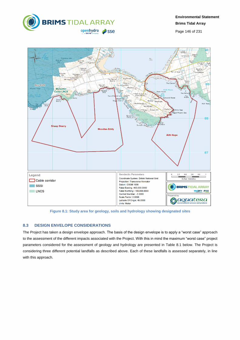
8.2 STUDY AREA
The geographical area for this assessment includes the three areas under consideration for the export cable to be brought
to shore, up to MHWS. The export cables will be brought to shore at one of three possible landfall locations (Sheep Skerry,
Moodies Eddy or Aith Hope) as shown on Figure 8.1.
Environmental Statement
Brims Tidal Array
Page 146 of 231
Figure 8.1: Study area for geology, soils and hydrology showing designated sites
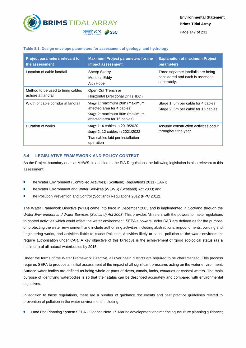
8.3 DESIGN ENVELOPE CONSIDERATIONS
The Project has taken a design envelope approach. The basis of the design envelope is to apply a “worst case” approach
to the assessment of the different impacts associated with the Project. With this in mind the maximum “worst case” project
parameters considered for the assessment of geology and hydrology are presented in Table 8.1 below. The Project is
considering three different potential landfalls as described above. Each of these landfalls is assessed separately, in line
with this approach.
Environmental Statement
Brims Tidal Array
Page 147 of 231
Table 8.1: Design envelope parameters for assessment of geology, and hydrology
Project parameters relevant to
the assessment
Maximum Project parameters for the
impact assessment
Explanation of maximum Project
parameters
Location of cable landfall Sheep Skerry
Moodies Eddy
Aith Hope
Three separate landfalls are being
considered and each is assessed
separately.
Method to be used to bring cables
ashore at landfall
Open Cut Trench or
Horizontal Directional Drill (HDD)
Width of cable corridor at landfall Stage 1: maximum 20m (maximum
affected area for 4 cables)
Stage 2: maximum 80m (maximum
affected area for 16 cables)
Stage 1: 5m per cable for 4 cables
Stage 2: 5m per cable for 16 cables
Duration of works Stage 1: 4 cables in 2019/2020
Stage 2: 12 cables in 2021/2022
Two cables laid per installation
operation
Assume construction activities occur
throughout the year
8.4 LEGISLATIVE FRAMEWORK AND POLICY CONTEXT
As the Project boundary ends at MHWS, in addition to the EIA Regulations the following legislation is also relevant to this
assessment:
The Water Environment (Controlled Activities) (Scotland) Regulations 2011 (CAR);
The Water Environment and Water Services (WEWS) (Scotland) Act 2003; and
The Pollution Prevention and Control (Scotland) Regulations 2012 (PPC 2012).
The Water Framework Directive (WFD) came into force in December 2003 and is implemented in Scotland through the
Water Environment and Water Services (Scotland) Act 2003. This provides Ministers with the powers to make regulations
to control activities which could affect the water environment. SEPA’s powers under CAR are defined as for the purpose
of ‘protecting the water environment’ and include authorising activities including abstractions, impoundments, building and
engineering works, and activities liable to cause Pollution. Activities likely to cause pollution to the water environment
require authorisation under CAR. A key objective of this Directive is the achievement of ‘good ecological status (as a
minimum) of all natural waterbodies by 2015.
Under the terms of the Water Framework Directive, all river basin districts are required to be characterised. This process
requires SEPA to produce an initial assessment of the impact of all significant pressures acting on the water environment.
Surface water bodies are defined as being whole or parts of rivers, canals, lochs, estuaries or coastal waters. The main
purpose of identifying waterbodies is so that their status can be described accurately and compared with environmental
objectives.
In addition to these regulations, there are a number of guidance documents and best practice guidelines related to
prevention of pollution in the water environment, including:
Land Use Planning System SEPA Guidance Note 17. Marine development and marine aquaculture planning guidance;
Environmental Statement
Brims Tidal Array
Page 148 of 231
The guidance advises that water quality and potential pollution risks should be reported in the ES and that the
principles included in the Pollution Prevention Guidelines and CIRIA C584 should be considered;
CIRIA (Construction Industry Research and Information Association) Report C532, Control of water,
pollution from construction sites: Guidance for consultants and contractors;
CIRIA Report C584D, Coastal and marine environmental site guide (C584D); and
SEPA pollution prevention guidance: Available at: http://www.sepa.org.uk/regulations/water/guidance/.
8.5 SUPPORTING SURVEYS AND STUDIES
The geological information is summarised from the desk based Geological and Hydrological Baseline Study
(Supporting Document: Flett Brown, 2015) undertaken by Dr John Flett Brown. The report examines the topography,
potential flooding, regional geology, structural geology, hydrology and groundwater flow with statutory hazard
evaluation for an area including south Hoy and a region of the Pentland Firth centred on the peninsula of Brims
stretching to about 4km south.
Technical data used within these reports include multibeam echo-sounder (MBES) survey data, sidescan sonar survey
data, geological maps, surface water flow maps and water table maps.
8.6 DATA GAPS AND UNCERTAINTIES
Given the extensive publicly available datasets for the Pentland Firth and Orkney Waters strategic development area and
site-specific survey work undertaken for the Project no significant data gaps or uncertainties related to the Geology and
Hydrology assessment have been identified.
The Sheep Skerry corridor was included as an additional cable route corridor and landfall option after extensive geophysical
surveys were carried out for the original Project Area of Search. A multi-beam echo-sounder (Supporting Document:
Aquatera, 2015c) and benthic ROV survey have since been carried out within the Sheep Skerry corridor and provide good
coverage of the seabed. However, no sidescan sonar survey work was carried out which would supplement the MBES to
provide additional baseline information on seabed texture and features on the seabed. Nevertheless, the information
available is deemed sufficient to carry out an appropriate assessment of the conditions of the seabed and its suitability as
a potential cable route corridor.
The landfall Area of Search (AoS) in the Sheep Skerry corridor was assessed during the previous site walkover and an
initial assessment of landfall suitability (subsequently leading to its identification as a potential option) was made. This
assessment is further augmented with information from the Sheep Skerry Phase 1 Habitat and Intertidal surveys
(Supporting Document: Aquatera, 2015a) carried out to inform the baseline of the Coastal and Terrestrial Ecology Chapter.
Therefore sufficient information is available to carry out an appropriate assessment of the Sheep Skerry landfall AoS.
A minor uncertainty lies around the design envelope for the landfall cable as the location and installation method has not
been finalised. As a result the impacts assessed assume a worst case scenario for the three landfall options rather than
specific impacts relating to one particular site. This approach allows for in a robust assessment which ensures that the
worst case impact is considered.

Environmental Statement
Brims Tidal Array
Page 149 of 231
8.7 CONSULTATIONS
Feedback from consultations are summarised in Chapter 6 Consultation Process. The key points raised by stakeholders
regarding geology, soils and hydrology are presented in Table 8.2. These comments were raised during the Scoping
consultation. At the time of Scoping, some onshore infrastructure around and beyond MHWS was being considered.
However, the current application does not include any infrastructure beyond the export cables up to MHWS.
Table 8.2: Key issues raised by stakeholder during consultation
Topic Stakeholder Comment Response/Action taken Section cross-
reference
Drainage
systems
SEPA Pollution from site activities Follow SEPA Controlled
Activities Regulations
(CAR)
See Section 8.9.4
Drainage
systems
SEPA Sustainable drainage systems Ensure all developments
treated by Sustainable
Drainage Systems are in
line with Scottish Planning
Policy
The Offshore Project
does not involve
infrastructure in the
onshore area.
Flooding SEPA Risk of flooding to site Assess SEPA Flood Maps See Section 8.9.4
Geology OIC A draft geological Local Nature
Conservation Site, known as
Melsetter Coast, is located on the
South Hoy coast, to the west of the
Area of Search for the cable landfall
area. The site extends between
Sheep Skerry and Sands Geo and
consists of a restricted outcrop of
the Hoy Lavas. The lava forms a
distinctive coastal platform in front of
a small dune system at Melberry.
Considered in assessment
of potential landfall corridor
at Sheep Skerry.
See Section 8.9.7
8.8 ASSESSMENT METHODOLOGY
8.8.1 Assessment Criteria
The general methodology used for this assessment is described in Chapter 7 EIA Scope and Methodology.
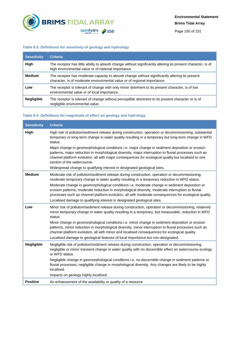
Table 8.3 defines the sensitivity for the various environmental receptors considered in this chapter.
Table 8.4 provides examples of the criteria that were used to classify the potential magnitude of impacts on different
components of the physical environment. Table 8.5 provides the impact significance considering the sensitivity of the
receptor and the magnitude of the impact.
A matrix approach has been used in combination with expert judgement and experience from other development projects
concerning the geological and hydrological environment to determine impact significance to the geological, hydrological
and soil receptors.
Environmental Statement
Brims Tidal Array
Page 150 of 231
Table 8.3: Definitions for sensitivity of geology and hydrology
Sensitivity Criteria
High The receptor has little ability to absorb change without significantly altering its present character, is of
high environmental value or of national importance.
Medium The receptor has moderate capacity to absorb change without significantly altering its present
character, is of moderate environmental value or of regional importance.
Low The receptor is tolerant of change with only minor detriment to its present character, is of low
environmental value or of local importance.
Negligible The receptor is tolerant of change without perceptible detriment to its present character or is of
negligible environmental value.
Table 8.4: Definitions for magnitude of effect on geology and hydrology
Sensitivity Criteria
High High risk of pollution/sediment release during construction, operation or decommissioning, substantial
temporary or long-term change in water quality resulting in a temporary but long-term change in WFD
status.
Major change in geomorphological conditions i.e. major change in sediment deposition or erosion
patterns, major reduction in morphological diversity, major interruption to fluvial processes such as
channel platform evolution, all with major consequences for ecological quality but localised to one
section of the watercourse.
Widespread change to qualifying interest in designated geological sites.
Medium Moderate risk of pollution/sediment release during construction, operation or decommissioning,
moderate temporary change in water quality resulting in a temporary reduction in WFD status.
Moderate change in geomorphological conditions i.e. moderate change in sediment deposition or
erosion patterns, moderate reduction in morphological diversity, moderate interruption to fluvial
processes such as channel platform evolution, all with moderate consequences for ecological quality.
Localised damage to qualifying interest in designated geological sites.
Low Minor risk of pollution/sediment release during construction, operation or decommissioning, relatively
minor temporary change in water quality resulting in a temporary, but measurable, reduction in WFD
status.
Minor change in geomorphological conditions i.e. minor change in sediment deposition or erosion
patterns, minor reduction in morphological diversity, minor interruption to fluvial processes such as
channel platform evolution, all with minor and localised consequences for ecological quality.
Localised damage to geological features of local importance but non-designated.
Negligible Negligible risk of pollution/sediment release during construction, operation or decommissioning,
negligible or minor transient change in water quality with no discernible effect on watercourse ecology
or WFD status.
Negligible change in geomorphological conditions i.e. no discernible change in sediment patterns or
fluvial processes, negligible change in morphological diversity. Any changes are likely to be highly
localised.
Impacts on geology highly localised
Positive An enhancement of the availability or quality of a resource
Environmental Statement
Brims Tidal Array
Page 151 of 231
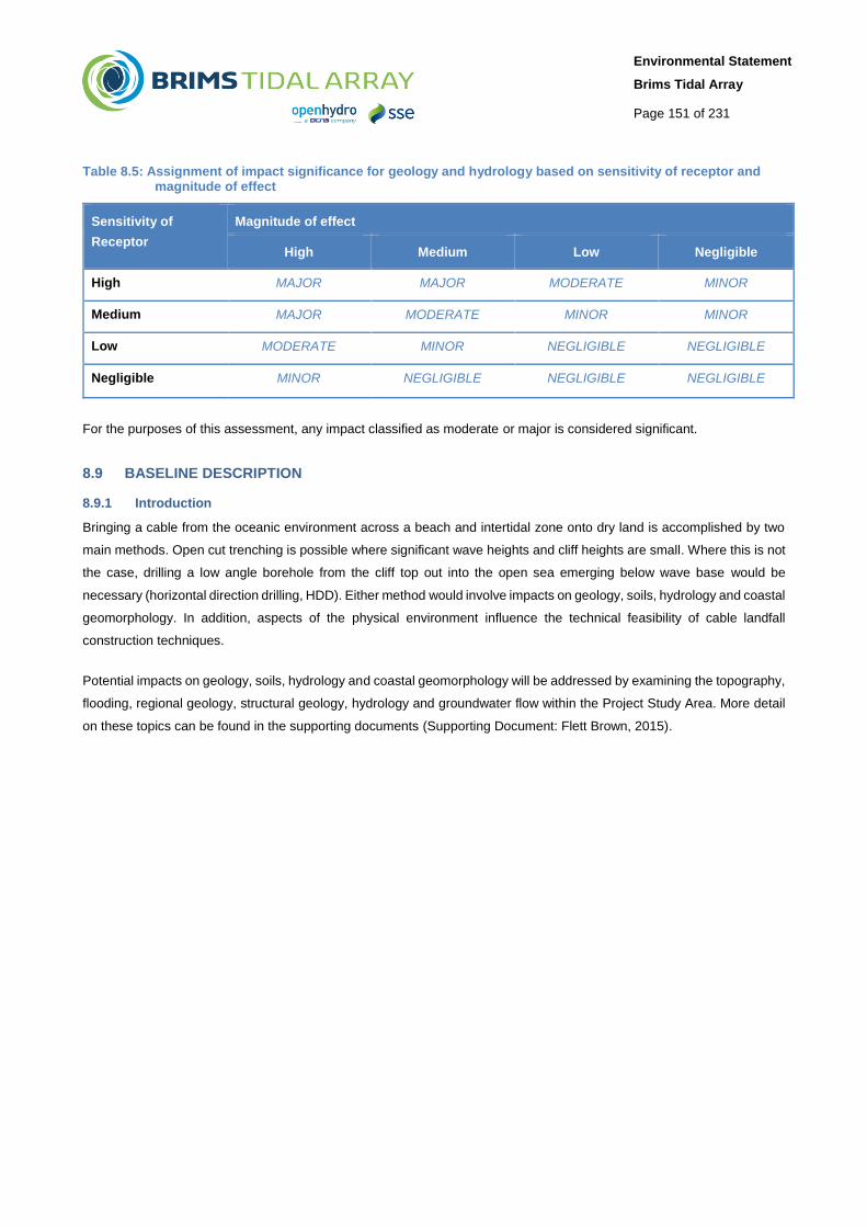
Table 8.5: Assignment of impact significance for geology and hydrology based on sensitivity of receptor and magnitude of effect
Sensitivity of
Receptor
Magnitude of effect
High Medium Low Negligible
High MAJOR MAJOR MODERATE MINOR
Medium MAJOR MODERATE MINOR MINOR
Low MODERATE MINOR NEGLIGIBLE NEGLIGIBLE
Negligible MINOR NEGLIGIBLE NEGLIGIBLE NEGLIGIBLE
For the purposes of this assessment, any impact classified as moderate or major is considered significant.
8.9 BASELINE DESCRIPTION
8.9.1 Introduction
Bringing a cable from the oceanic environment across a beach and intertidal zone onto dry land is accomplished by two
main methods. Open cut trenching is possible where significant wave heights and cliff heights are small. Where this is not
the case, drilling a low angle borehole from the cliff top out into the open sea emerging below wave base would be
necessary (horizontal direction drilling, HDD). Either method would involve impacts on geology, soils, hydrology and coastal
geomorphology. In addition, aspects of the physical environment influence the technical feasibility of cable landfall
construction techniques.
Potential impacts on geology, soils, hydrology and coastal geomorphology will be addressed by examining the topography,
flooding, regional geology, structural geology, hydrology and groundwater flow within the Project Study Area. More detail
on these topics can be found in the supporting documents (Supporting Document: Flett Brown, 2015).

Environmental Statement
Brims Tidal Array
Page 152 of 231
Figure 8.2: Geology of the study area
8.9.2 Onshore Geology
In the study area of Melsetter, Brims and Longhope comprising the Area for Lease (AfL) area and potential cable landfalls
the geology consists of Middle Devonian flagstones and sandstones (See Figure 8.2). This area is bisected by the
approximately north-south Brims – Risa Fault zone, a high angle reversed fault extending from Houton, through Hoy across
the Pentland Firth to Brough and on to central Caithness. The older upper Stromness and Rousay Flagstone Formations
are found mainly on the eastern side of the Brims – Risa Fault. The lower Eday Sandstone and the Hoy volcanics lie close
to the eastern side of the fault and are caught in the bifurcation of the fault system. Hoy sandstones are located on the
west side of the fault.
This Brims–Risa Fault throws down to the west, ± 200m, putting younger rocks of the Hoy Sandstone Group against older
rocks of Rousay and Lower Eday age on the east. On the south coast of Hoy near Witter Hill the Brims–Risa Fault is clearly
a reversed fault which heads east at 60°. These flagstones are deformed for about 12m within a fault crush zone. The style
of deformation adjacent to and within the fault zones indicates that they are sinistral strike-slip faults, with a reverse
displacement.
Environmental Statement
Brims Tidal Array
Page 153 of 231
The major reverse faults dip east, between 50° and 85° and include the Brough, Brims–Risa and East Scapa faults.
Early extensional tectonics during the Middle Devonian probably initiated the major fracture systems which were then
reactivated as thrusts faults during the Permian inversion of this area. These faults are probably related to the “Great Glen”
left-lateral transcurrent fault which passes close to the eastern side of Orkney. Although small-scale movements still occur
on the “Great Glen” at the present time fault movement and seismic events are not considered as major hazards over the
AFL.
The upper Stromness and Rousay Flagstone formation consist of cycles of lacustrine sediments including siltstones and
mudstones interbedded with sandstones. These cycles follow the 100,000 year Milankovitch eccentricity cycle which
controlled the climate during the wet periods of the Lake Orcadie sedimentary system. During the maximum wet periods
permanent Lake conditions existed over the area for about 10,000 years during which fish remains were preserved on the
lake bed. There is a basal fish bed within the Rousay Formation containing fossil fish (Osteolepis panderi) and
stromatolites. About 210m of Rousay Formation is estimated on the Brims Peninsula.
Lower Eday Sandstone is exposed in the west of South Walls. It joins the Brims–Risa Fault east of Binga Fea. At the
exposure on the shore of Aith Hope it is with a wide zone of crushed and crumpled beds. The formation consists of a lower
unit of mixed sandstones and mudstones, with the proportion of sand increasing upwards. This passes into an upper,
thicker sandstone unit incorporating fluvial, aeolian and beach deposits. At Brims site the upper porous aeolian facies is ±
50m thick in a total section of ± 130m.
The Hoy Volcanic Formation is of variable thickness throughout Orkney reaching its largest extant in Rackwick and North
Hoy. The lower member is a relatively thick tuff or tuffaceous sandstone up to 15m thick. This is overlain by alkali basalt,
20m thick.
The Hoy Sandstone Formation found on the western side of the fault system is a monotonous succession of braided fluvial
sandstones of Givetian age — Frasnian Age consisting of red, pink, and yellow sandstones with subordinate bands of marl.
Many exhibit current bedding and trace fossils. These rocks were deposited as the Orcadian Basins evolved to a system
of “through drainage”.
8.9.3 Topography
Orkney's topography is generally low lying with smooth relief. The highest areas reach over 200m, but the majority of the
archipelago is below 100m, with significant areas below 30m. This topography was formed by ice sheets and glaciers
passing over the islands during the last Ice Age. Hoy has higher and more dramatic topography than the rest of Orkney,
with heights in the north of the island frequently over 300 or 400m. The highest point is the Ward Hill of Hoy, which at 479m
is also the highest point in Orkney. Central and southern Hoy are slightly lower and more undulating than the north, although
much land remains over 200m. Along the west coast this height is expressed in Hoy’s cliffs which reach over 300m high in
the north, reducing gradually towards the south.

Environmental Statement
Brims Tidal Array
Page 154 of 231
High cliff coastlines are a feature of the south west tip of the island of Hoy. The rich variety of cliff and cliff-related forms
along this coast include steep and overhung profiles; sea-stacks; arches; caves; and shore platforms, all reflecting the
dominant geological control of horizontally bedded, fractured and faulted Devonian Sandstone. Near to the study area,
high cliff coastlines are a prominent feature. Exposed abrasion surfaces slope at a gentle angle towards the sea where the
coastline is more dominated by shingle and boulder beaches. The effect of high energy wave action on the gently inclined
sedimentary rocks has been to produce a
series of constantly eroding and evolving near-
vertical cliffs.
The littoral zone of the study area is
characterised by mixed boulder and cobble
beaches and wave cut platform slabs, backed
by cliffs. The majority of the study area has
foreshore backed by wave eroded rocky cliffs
from 6m to 38m high. Only 1.9km of the study
area, principally within the inner part of Aith
Hope, has low sloping beaches with very low,
1 – 2m, and erosional soil and boulder clay cliff
lines behind the beach.
8.9.3.1 Sheep Skerry
The Melsetter Links have been a working source of constructional sand in Hoy. The excavation of sand lies behind around
10m high dunes. These dunes separate it from the shore. On the west side there is a stream that cuts through the dune
complex on to the beach with about a 2° access slope over some 200m. On the west side of the links is the volcanic plug
outcrop of Melberry. The land behind this potential landing spot is low lying rising slowly to about 17m before decreasing
down to sea level near the Lodge of Melness and into North Bay.
8.9.3.2 Moodies Eddy
This section of coast consists of large boulders on top of bedrock backed by a 6m to 10m cliff with bare bedrock extending
about 500m to 800m from the shoreline. As such it is unsuitable for an open cut trench cable landing solution; therefore
HDD would be likely in this location.
8.9.3.3 Aith Hope
To the west of this AoS is bare rock rising to 6m in the western part with cliffs of 16m height in the eastern part. This
coastline is not conducive for a trenched cable landfall. The underlying rock is Rousay Flagstone and it likely would be
necessary to drill across fault zones.
This coastal section which includes Brims Village lies north west/south east under the ridge of Brims Peninsula rising
steeply behind the village to about 35m. This geography shelters this whole coastline from the prevailing west and south
west winds. South of the lifeboat station the land is low for about 200m. It then rises to the headland of Brims Ness at 15m.
Figure 8.3 Melsetter (JF Brown, 2015)
Environmental Statement
Brims Tidal Array
Page 155 of 231
North Aith Hope has a gradient of about 1.5° from the sea up to the 2m contour this makes for an easy trench access.
The Clevies extend from the low lying shore of Aith Hope north to shoreline with a backing cliff of 4m which rises to 15m.
Behind the shoreline these the small cliffs are in Lower Eday Sandstone's which are quite homogeneous and very suitable
for horizontal drilling solutions. The presence of the major faults system about 150m behind the cliff may put constraints
on such horizontal drilling solutions.
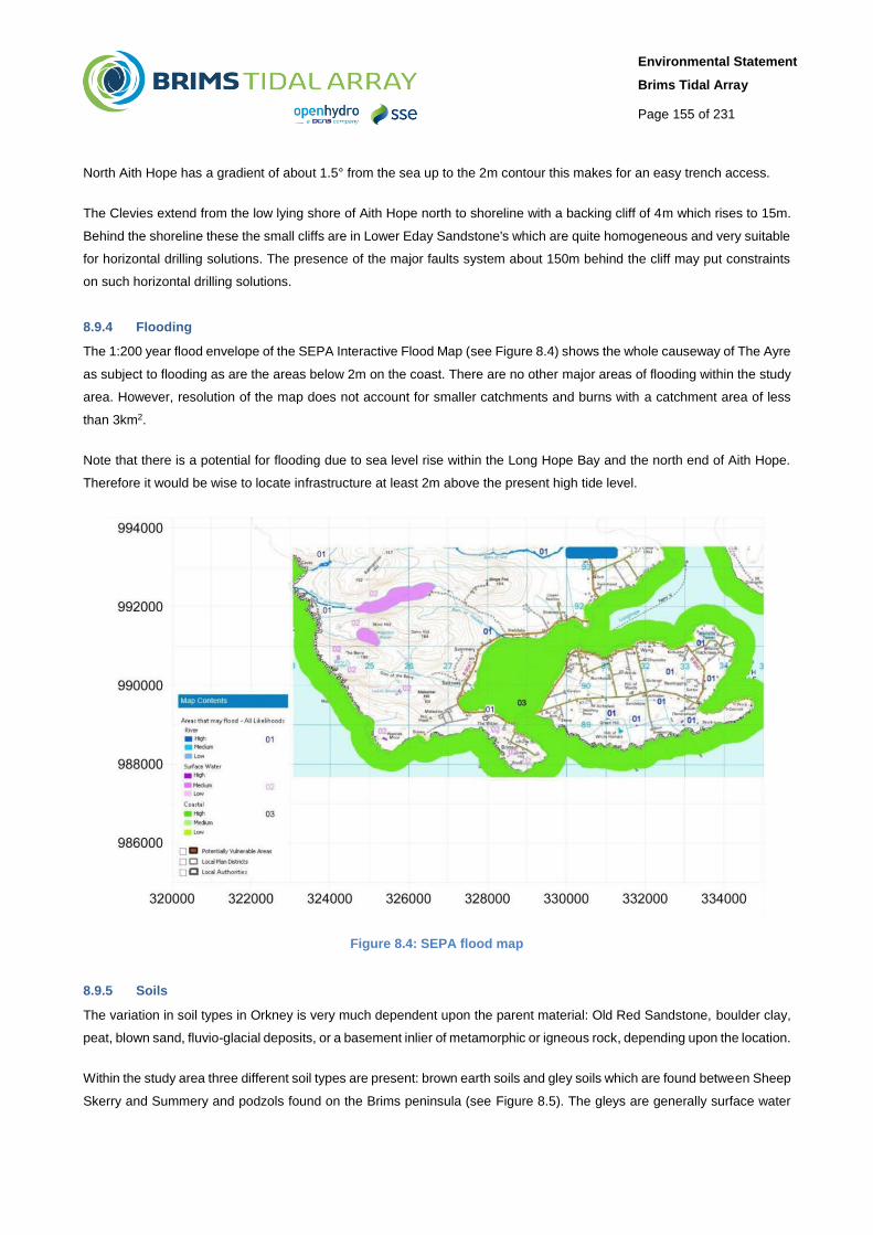
8.9.4 Flooding
The 1:200 year flood envelope of the SEPA Interactive Flood Map (see Figure 8.4) shows the whole causeway of The Ayre
as subject to flooding as are the areas below 2m on the coast. There are no other major areas of flooding within the study
area. However, resolution of the map does not account for smaller catchments and burns with a catchment area of less
than 3km2.
Note that there is a potential for flooding due to sea level rise within the Long Hope Bay and the north end of Aith Hope.
Therefore it would be wise to locate infrastructure at least 2m above the present high tide level.
Figure 8.4: SEPA flood map
8.9.5 Soils
The variation in soil types in Orkney is very much dependent upon the parent material: Old Red Sandstone, boulder clay,
peat, blown sand, fluvio-glacial deposits, or a basement inlier of metamorphic or igneous rock, depending upon the location.
Within the study area three different soil types are present: brown earth soils and gley soils which are found between Sheep
Skerry and Summery and podzols found on the Brims peninsula (see Figure 8.5). The gleys are generally surface water

Environmental Statement
Brims Tidal Array
Page 156 of 231
gleys in which the downward movement of water is hindered. The brown soils develop on the more strongly sloping land
and are often characterised by hardened horizons. The brown soils and non-calcareous gleys are capable of supporting
arable crops and permanent grass, and peaty gleys can support some grassland.
Figure 8.5: Soil types within the study area
8.9.6 Hydrology and Hydrogeology and Groundwater Flow
There are no watercourses flowing into the sea within the study area. The water table in the study area is almost the same
as surface elevation at the coast. Surface flow of precipitation and groundwater flow within the aquifers are very similar as
a result of this. The direction of water flow within the water table in the study area is towards to coast. As a result of this if
any pollution event does occur, it is unlikely to affect the ground water but flow into the sea instead.
The Old Head to Tor Ness water body (WB ID 200222) has been identified as overlapping with the BTAL AfL and has been
classified by SEPA as having an overall status of Good with High confidence in 2013 with overall ecological status of Good
and overall chemical status of Pass. SEPA set environmental objectives for this water body over future river basin planning
cycles in order that sustainable improvements to its status can be made over time, or alternatively that no deterioration in
Environmental Statement
Brims Tidal Array
Page 157 of 231
status occurs, unless caused by a new activity providing significant specified benefits to society or the wider environment
(SEPA 2016).
8.9.7 Designated Sites
The only designated site with geological interest within the study area is the Melsetter Coast Local Nature Conservation
Site (LNCS). This is a 6.0 hectare area that was designated due to the Hoy Lava outcrop which is found between Sheep
Skerry and Sands Geo. The lava forms a distinctive coastal platform in front of a small dune system at Mulberry. On the
west, north and east the lava is bounded by Monchique dykes and only the top of the flow is visible. To the west the lava
is overlain by channelled and cross-bedded Hoy Sandstone which is well exposed as far as Ha Wick. Further to the north,
the cliffs rise sharply to over 180m and the exposure becomes inaccessible. The Sheep Skerry landfall area of search is
located within this site (Figure 8.1).
8.9.8 Summary
The underlying geology of the study area is middle Devonian sediments consisting of the Caithness Flagstone group and
the overlying Eday Sandstone group. These are characterised by fine to medium grained sandstones, siltstones and
mudstones. There is also a section of Hoy Lava which is designated as a Local Nature Conservation Site at Melsetter
Coast. The Sheep Skerry landfall AoS is located within this designated site. The littoral zone is characterised by mixed
boulder and cobble beaches and wave cut platform slabs, backed by cliffs. Soils are brown earth, gley soils and podzols.
There are no watercourses flowing into the sea within the study area. The study area is also outside the 1:200 year flood
envelope.
Open cut trenching could be undertaken at Sheep Skerry or North Aith Hope. Other potential landfalls would necessarily
involve HDD. There are no watercourses flowing into the sea within the study area, and no private water supplies, so no
direct or indirect impacts on watercourses or private water supplies are anticipated.
8.10 POTENTIAL IMPACTS
8.10.1 Construction and Installation
Contamination of soils, surface water or groundwater from spills; and
Disturbance or loss of features of geological interest.
8.10.2 Operation and Maintenance
Disturbance of loss of features of geological interest.
8.10.3 Decommissioning
Contamination of soils, surface water or groundwater from spills; and
Disturbance or loss of features of geological interest.
Environmental Statement
Brims Tidal Array
Page 158 of 231
8.11 MITIGATION MEASURES
8.11.1 Project Design Mitigation and General Mitigation
All Project Design and General Mitigation measures are set out in Chapter 5 Project Description, Table 5.15 and Table
5.16 respectively. These are standard practice measures based on specific legislation, regulations, standards, guidance
and recognised industry good practice that are put in place to ensure significant impacts do not occur.
8.11.2 Specific Mitigation
The assessment of the potential effects on the baseline physical processes environment has revealed that no potentially
significant impacts will arise to the identified shoreline geological, hydrological and soil receptors following implementation
of best practice guidance as outlined in general mitigation measures. Due to this, no specific mitigation measures have
been identified for these receptors.
8.12 RESIDUAL EFFECTS
8.12.1 Construction and Installation
8.12.1.1 Contamination of Soils, Surface Water or Groundwater from Spills
The effects of contamination would be the same for each landfall AoS.
During construction activity, potential pollutants will be present in the site area. These will include fuel, lubrication oils,
chemicals, unset concrete, grout and drilling fluid as well as waste water from staff facilities. Any pollution incident occurring
on site may adversely affect the quality of nearby surface waters, groundwater or site soils. Through implementation of the
mitigation measures listed in Section 8.11 any residual impacts on WFD objectives, will be not significant.
The length of the cable to be trenched will be short (i.e. across the intertidal and possibly the shallow near-shore zones
only) as a result any spills or pollution around this area would run directly into the sea and not surface waters, ground
waters or site soils. Spills or pollution events further inland relating to machinery and staff facilities would be very localised.
The soils in the area are poorly drained so spills and pollution would take a long time to permeate into the soils, resulting
in the pollution having likely been contained before any impact could occur. The ground and surface waters in the study
area all run towards the sea so any spills would be unlikely to accumulate in the surface and ground waters but run into
the Pentland Firth which would have an impact on the local marine ecology (see Chapter 14 Ornithology, Chapter 13
Marine Mammals, Chapter 12 Fish Ecology and Chapter 11 Benthic Ecology).
For HDD there will be more lubrication oils and drilling fluid present. As a result a pollution event would have a higher
likelihood of occurring. The drilling locations for HDD would mean that due to the ground and surface waters run into the
sea any spills would be unlikely to accumulate in the ground or surface water but run into the Pentland Firth which would
impact on the local marine ecology.
Any contamination of soils, surface water or ground water from spills would therefore be low in magnitude, temporary in
duration, caused by infrequent activities and reversible within a very short period of time.

Environmental Statement
Brims Tidal Array
Page 159 of 231
Table 8.6: Summary of residual effects soils and water during construction and installation
Technology
Option
Receptor Sensitivity Mitigation Residual
Magnitude
Summary Residual
Significance
Contamination of
Soils, Surface
Water or
Groundwater
from Spills
Soils, surface
water and ground
water within the
Melsetter, Brims
and Longhope
area and
potential cable
landfalls, Old
Head to Tor Ness
Waterbody
Low N/A Minor Contamination
would be low in
magnitude,
temporary and
reversible within a
very short period
of time
Minor
8.12.1.2 Disturbance or Loss of Features of Geological Interest
Sheep Skerry
During construction activity some of the bedrock will have to be removed for the landfall cables using either HDD or open
cut trench techniques. The landfall at Sheep Skerry is a designated LNCS for the outcrop of Hoy Lava that is present here
making this site the worst case site.
For trenching this could cause localised damage to the bedrock and superficial geology and may result in fracturing within
nearby sections of the bedrock due to the trenching occurring at the surface. The length of the cable to be trenched will be
relatively short. The back fill of the trenches will likely use the rock that was excavated. If fracturing of the nearby sections
occurs it will be very localised and unlikely to cause noticeable damage to features of geological interest, such as the Hoy
Lavas which are a LNCS. Therefore disturbances or loss of geological interest will be low in magnitude, localised but
permanent.
However, if the Sheep Skerry corridor is to be utilised as a landfall corridor, the laval outcrop would be avoided as it would
be impractical to bring export cables to shore at this location, and a median path is likely to be selected which follows a
relatively gentle path through the rippled sand avoiding rocky outcrops.
The Sheep Skerry corridor is potentially of medium sensitivity, however as this area is likely to be avoided, the magnitude
of impacts is likely to be low and impact significance is assessed as minor.
Table 8.7: Summary of residual impacts on features of geological interest during construction and installation
Technology
Option
Receptor Sensitivity Mitigation Residual
Magnitude
Summary Residual
Significance
Disturbance or
loss of
features of
geological
interest
Melsetter
Coast LNCS
Medium N/A Low Localised
removal and
fracturing of
bedrock
should be
avoided at
Sheep Skerry
Minor

Environmental Statement
Brims Tidal Array
Page 160 of 231
8.12.2 Operation and Maintenance
The only impact with any probability of occurring during the Operational Phase is the result of contamination during
maintenance activity. There is no scheduled maintenance for the landfalls and export cables, therefore any maintenance
activity would be limited to rare occurrences where a cable had to be dug up and reburied. These impacts are expected to
be very similar in nature to construction impacts and would be avoided through the implementation of best practice
measures for pollution prevention.
Table 8.8: Summary of residual effects of the on geology, soils and hydrology
Technology
Option
Receptor Sensitivity Mitigation Residual
Magnitude
Summary Residual
Significance
Disturbance or
loss of features
of geological
interest
Melsetter
Coast LNCS
Medium N/A Low Localised removal and
fracturing of bedrock
should be avoided at
Sheep Skerry
Minor
8.12.3 Decommissioning
The intended Project lifetime is 25 years, and after such time, the Project will either be decommissioned, involving the full
or partial removal of onshore elements, or repowered. Any decommissioning or repowering programme will cause effects
that are similar in type but lower magnitude than during the construction phase; refer to
Environmental Statement
Brims Tidal Array
Page 161 of 231
Table 8.6 8.6 and Table 8.7.
8.13 SUMMARY
Open cut trenching and horizontal directional drilling (HDD) for the landfall will involve impacts on geology, soils,
hydrology and coastal geomorphology within the study area.
The Sheep Skerry and North Aith Hope areas are most likely to involve open cut trenching, while other landfalls would
necessarily involve HDD.
The Melsetter Coast LNCS is designated for geological interest. The Sheep Skerry landfall is within this designated
site. However, impacts on this site due to trenching are not expected to be significant as there would be only localised
damage to the bedrock and superficial geology and if fracturing of the nearby sections occurs it will be very localised
and unlikely to cause noticeable damage to features of geological interest, such as the Hoy Lavas.
There is the potential for contamination of soils, surface water or groundwater from spills. However, general mitigation
measures to implement best practice measures for pollution control and prevention will keep these impacts from
becoming significant.
There are no watercourses flowing into the sea within the study area and as the study area ends at MHWS, no impacts
associated with groundwater flow are anticipated.
The 1:200 year flood envelope of the SEPA Interactive Flood Map shows the whole causeway of The Ayre as subject
to flooding as are the areas below 2m on the coast. There are no other major areas of flooding within the study area
and no permanent above ground infrastructure is included in this Project.
Maintenance activities needed for the export cables are anticipated to infrequent, and impacts would be similar to
those for construction.
Decommissioning, or repowerment, will occur after the 25 year intended lifespan. In the case of decommission, full or
partial removal of onshore elements will occur. Decommissioning or repowerment will involve similar, but reduced,
impact seen during construction.
8.14 REFERENCES
Orkney Islands Council, Natural Heritage Annex 1: Local Nature Conservation Sites, June 2012.
SEPA Water body information sheet for water body 200222 in Orkney and Shetland (Accessed via
http://www.environment.scotland.gov.uk/get-interactive/data/water-body-classification/ February 2016)