
Geological Society of America Bulletinsmalley/CERI7280F2016/Geol Soc America... · Andean tectonics...
22
Geological Society of America Bulletin doi: 10.1130/0016-7606(1983)94<341:ATRTGO>2.0.CO;2 1983;94, no. 3;341-361 Geological Society of America Bulletin A. RAMOS and CLIFFORD J. ANDO TERESA E. JORDAN, BRYAN L. ISACKS, RICHARD W. ALLMENDINGER, JON A. BREWER, VICTOR Andean tectonics related to geometry of subducted Nazca plate Email alerting services cite this article to receive free e-mail alerts when new articles www.gsapubs.org/cgi/alerts click Subscribe America Bulletin to subscribe to Geological Society of www.gsapubs.org/subscriptions/ click Permission request to contact GSA http://www.geosociety.org/pubs/copyrt.htm#gsa click viewpoint. Opinions presented in this publication do not reflect official positions of the Society. positions by scientists worldwide, regardless of their race, citizenship, gender, religion, or political article's full citation. GSA provides this and other forums for the presentation of diverse opinions and articles on their own or their organization's Web site providing the posting includes a reference to the science. This file may not be posted to any Web site, but authors may post the abstracts only of their unlimited copies of items in GSA's journals for noncommercial use in classrooms to further education and to use a single figure, a single table, and/or a brief paragraph of text in subsequent works and to make employment. Individual scientists are hereby granted permission, without fees or further requests to GSA, Copyright not claimed on content prepared wholly by U.S. government employees within scope of their Notes Geological Society of America on June 3, 2012 gsabulletin.gsapubs.org Downloaded from
Transcript of Geological Society of America Bulletinsmalley/CERI7280F2016/Geol Soc America... · Andean tectonics...

Geological Society of America Bulletin
doi: 10.1130/0016-7606(1983)94<341:ATRTGO>2.0.CO;2 1983;94, no. 3;341-361Geological Society of America Bulletin
A. RAMOS and CLIFFORD J. ANDOTERESA E. JORDAN, BRYAN L. ISACKS, RICHARD W. ALLMENDINGER, JON A. BREWER, VICTOR Andean tectonics related to geometry of subducted Nazca plate
Email alerting servicescite this article
to receive free e-mail alerts when new articleswww.gsapubs.org/cgi/alertsclick
SubscribeAmerica Bulletin
to subscribe to Geological Society ofwww.gsapubs.org/subscriptions/click
Permission request to contact GSAhttp://www.geosociety.org/pubs/copyrt.htm#gsaclick
viewpoint. Opinions presented in this publication do not reflect official positions of the Society.positions by scientists worldwide, regardless of their race, citizenship, gender, religion, or political article's full citation. GSA provides this and other forums for the presentation of diverse opinions andarticles on their own or their organization's Web site providing the posting includes a reference to the science. This file may not be posted to any Web site, but authors may post the abstracts only of theirunlimited copies of items in GSA's journals for noncommercial use in classrooms to further education and to use a single figure, a single table, and/or a brief paragraph of text in subsequent works and to makeemployment. Individual scientists are hereby granted permission, without fees or further requests to GSA, Copyright not claimed on content prepared wholly by U.S. government employees within scope of their
Notes
Geological Society of America
on June 3, 2012gsabulletin.gsapubs.orgDownloaded from
Andean tectonics related to geometry of subducted Nazca plate
Department of Geological Sciences, Cornell University, Ithaca, New York 14853
TERESA E. J O R D A N BRYAN L. ISACKS R I C H A R D W. A L L M E N D I N G E R JON A. BREWER* VICTOR A. R A M O S Servicio Geologico Nacional, Buenos Aires, Argentina C L I F F O R D J. ANDO* Department of Geological Sciences, Cornell University, Ithaca, New York 14853
ABSTRACT
Seismological and geological data show that tectonic segmen-tation of the Andes coincides with segmentation of the subducted Nazca plate, which has nearly horizontal segments and 30° east-dipping segments. Andean tectonics above a flat-subducting seg-ment between 28° S to 33° S are characterized by (from west to east): (1) a steady topographic rise f rom the coast to the crest of the Andes; (2) no significant Quaternary, and possibly Neogene, mag-matism; (3) a narrow belt of eastward-migrating, apparently thin-skinned, Neogene to Quaternary shortening of the Andes; and (4) Plio-Pleistocene uplift of the crystalline basement on reverse faults in the Pampeanas Ranges. From about 15°S to 24°S, over a 30°-dipping subducted plate, a west to east Andes cross section includes: (1) a longitudinal valley east of coastal mountains; (2) an active Neogene and Holocene andesitic volcanic axis; (3) the Altiplano-Puna high plateau; (4) a high Neogene but inactive thrust belt (Eastern Cordillera); and (5) an active eastward-migrating Subandean thin-skinned thrust belt. Tectonics above a steeply sub-ducting segment south of 33° S are similar west of the volcanic axis, but quite different to the east.
Early Cenozoic tectonics of western North America were quite similar to the Neogene Andes. However, duration of segmentation was longer and the width of deformation was greater in the western United States.
Patterns of crustal seismicity are systematically related to Plio-Quaternary structural provinces, implying that current deforma-tional processes have persisted since at least the Pliocene. Horizontal compression parallel to the plate convergence direction is indicated to a distance of 800 km f rom the trench. Above flat-subducting segments, crustal seismicity occurs over a broad region, whereas over steep segments, it is confined to the narrow thrust belt. Strain patterns in the forearc region are complex and perhaps extensional, and a broad region of the Altiplano-Puna and Eastern Cordillera appears to be aseismic.
INTRODUCTION
The Andes mountain system is commonly used as an illustra-tion of a "simple" orogen formed by subduction of an oceanic plate
' P r e sen t addresses: (Brewer) Department of Earth Sciences. Madding-ley Road, Cambridge CB3 OEZ. England; (Ando) Shell Development Company, P.O. Box 481. Houston, Texas 77001.
Geological Study of America Bulletin, v. 94, p. 341-361. 11 figs., March 1983.
beneath a continental margin (Dewey and Bird, 1970; James, 1971). Over much of its length, the Andes consist of a magmatic arc, flanked on the west by a trench and on the east by a foreland thrust belt and basin (Fig. 1). These characteristics of an "Andean-type margin" are recognized in the geological record of various conver-gent margins.
The Neogene Andes afford the outstanding opportunity to understand the coupling of subduction and continental orogenesis. They are primarily a noncollisional mountain belt formed along a long-lived, currently active subduction system. The Andes are an important exploration model for the generation of economic resources, both metals and hydrocarbons, in relation to plate inter-actions and paleogeographic controls.
Although the Andes are morphologically continuous along strike for more than 4,000 km (from about 5°S to 45°S), distinct broad-scale tectonic segments can be identified (Figs. 1 and 2). These tectonic segments are located above segments of similar scale in the subducted Nazca plate, defined by major along-strike varia-tions in the dip of the Benioff zone. The coincidence of lateral variations in the geometry of the descending Nazca plate and in Andean physiography and geology is remarkable. In addition, the eastern limit of Benioff zone seismicity coincides with the eastern deformation limit of the overriding South American plate.
There must be two significant controls on lateral tectonic seg-mentation: modern plate interactions and pre-existing inhomoge-neities in the South American plate. The western margin of the South American continent was intensely deformed during the Paleozoic and early Mesozoic, prior to the Andean Orogeny (Jurassic-Holocene). Apparent coincidences of ancient crustal boundaries with Neogene tectonic boundaries raise the possibility that features in the descending plate interact with pre-existing struc-ture of the upper plate, in combination producing the segmentation of Andean tectonics and of subducted plate geometry.
The role of Nazca plate segmentation as a control on upper-plate segmentation is perhaps best studied between 18°S to 40° S (Fig. 2), in Chile, Argentina, and Bolivia, where the Andes are straight, and convergence directions of the Nazca and South American plates are at a high angle to the plate margin (Chase, 1978; Minster and Jordan, 1978), and an arid climate produces good exposure. Farther north, segment transitions in southern Peru and Ecuador coincide with major changes in the trend of the Andes and the continental margin, adding possible complications result-ing f rom the shape of the plate margin. This paper will briefly sum-marize the seismological data and part of the extensive literature
341
on June 3, 2012gsabulletin.gsapubs.orgDownloaded from
342 JORDAN AND OTHERS
0 °
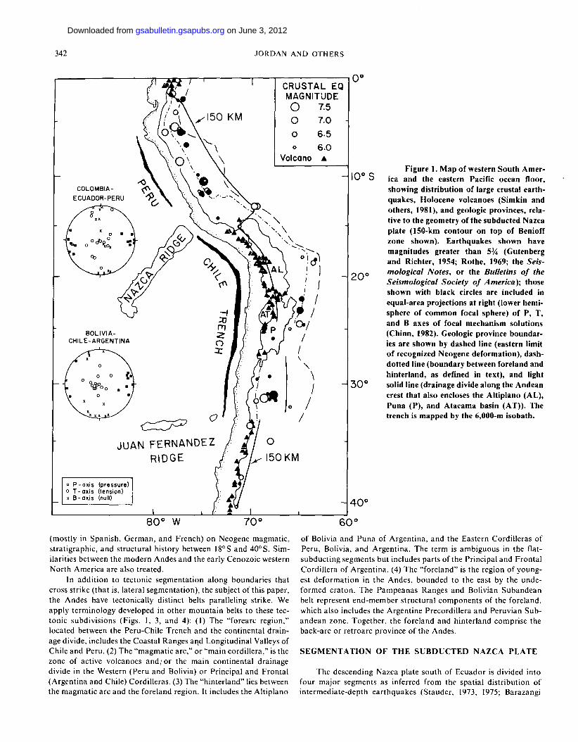
Figure 1. Map of western South Amer-i n ° c ivj o i c a and the eastern Pacific ocean floor,
showing distribution of large crustal earth-quakes, Holocene volcanoes (Simkin and others, 1981), and geologic provinces, rela-tive to the geometry of the subducted Nazca plate (lSO-km contour on top of Benioff zone shown). Earthquakes shown have magnitudes greater than 5% (Gutenberg and Richter, 1954; Rothe, 1969; the Seis-
2q0 mological Notes, or the Bulletins of the Seismological Society of America)-, those shown with black circles are included in equal-area projections at right (lower hemi-sphere of common focal sphere) of P, T, and B axes of focal mechanism solutions (Chinn, 1982). Geologic province boundar-ies are shown by dashed line (eastern limit of recognized Neogene deformation), dash-dotted line (boundary between foreland and hinterland, as defined in text), and light
3 0 0 solid line (drainage divide along the Andean crest that also encloses the Altiplano (AL), Puna (P), and Atacama basin (AT)). The trench is mapped by the 6,000-m isobath.
8 0 ° W 7 0 °
(mostly in Spanish, German , and French) on Neogene magmatic , s t rat igraphic, and structural history between 18°S and 40° S. Sim-ilarities between the m o d e r n Andes and the early Cenozoic western Nor th America are also treated.
In addi t ion to tectonic segmentat ion a long boundar ies that cross strike ( that is, lateral segmentat ion) , the subject of this paper , the Andes have tectonically distinct belts paralleling strike. We apply terminology developed in other mounta in belts to these tec-tonic subdivis ions (Figs. 1, 3, and 4): (1) The " forearc region," located between the Peru-Chile Trench and the continental drain-age divide, includes the Coastal Ranges and Longitudinal Valleys of Chile and Peru. (2) The "magmat ic arc ," or "main cordil lera," is the zone of active volcanoes a n d / o r the main cont inental drainage divide in the Western (Peru and Bolivia) or Principal and Fronta l (Argent ina and Chile) Cordil leras. (3) The "hinter land" lies between the magmat i c arc and the fore land region. It includes the Al t ip lano
4 0 °
60° of Bolivia and Puna of Argent ina , and the Eastern Cordil leras of Peru, Bolivia, and Argent ina . The term is ambiguous in the flat-subduct ing segments but includes parts of the Principal and Fronta l Cordil lera of Argent ina . (4) The " fo re land" is the region of young-est d e f o r m a t i o n in the Andes, bounded to the east by the unde-fo rmed cra ton . The P a m p e a n a s Ranges and Bolivian Subandean belt represent end-member s t ructural componen ts of the fore land, which also includes the Argent ine Precordillera and Peruvian Sub-a n d e a n zone. Together , the fore land and hinter land comprise the back-arc or re t roarc province of the Andes.
S E G M E N T A T I O N OF THE S U B D U C T E D N A Z C A PLATE
The descending Nazca plate south of Ecuador is divided into four m a j o r segments as inferred f r o m the spatial dis tr ibut ion of in termediate-depth ea r thquakes (Stauder , 1973, 1975; Barazangi
on June 3, 2012gsabulletin.gsapubs.orgDownloaded from

ANDEAN TECTONICS AND NAZCA PLATE 343
8 0 ° W 6 0 ° 4 0 °
Figure 2. Map of South America, showing locations of sub-horizontal segments of subducted Nazca plate ("flat-slab regions") relative to political boundaries. E, Ecuador; L, Lima; LP, La Paz; T, Tucuman; S, Santiago; BA, Buenos Aires.
and Isacks, 1976, 1979; Isacks and Barazangi, 1977). F rom abou t 2°S to 15°S and 27°S to 33°S, the Benioff zone dips only abou t 5° to 10° east, whereas f rom 15°S to 24° S and south of 33° S, the zone is inclined abou t 30° east (Figs. 1 and 2). The relatively abrup t transit ion between steep and flat parts of the subducting plate near I5°S was interpreted as a tear between the two segments by Bara-zangi and Isacks (1979), but Hasegawa and Sacks (1981) found evidence that it is instead a very sharp contor t ion of the plate. The geometry of the transit ion near 33° S is not as well known.
At the nor th end of the Chile-Argentina flat-subducted slab, there is a gap along strike (between 24°S-27°S) in the distr ibution of intermediate-depth (125-300 km) ear thquakes (indicated by the break along strike of the 150-km contour of hypocentral depth in Figs. 1 and 4b). The mant le in this area appears to be virtually aseismic, based on a careful search for well-located events for the period 1950-1979. Continui ty of forearc features and magmatic-arc features suggests that the major change f rom steep to flat subduc-tion occurs near 27° S. Above the aseismic region, there is an area of complex transit ional tectonics in the upper plate (see below).
The down-dip lengths of the two nearly flat segments of the subducted plate are similar, abou t 750 km measured f rom the axis
of the trench to a dep th of a b o u t 160 km (Fig. 3). The intervening more steeply dipping segment is slightly shorter , abou t 650 to 700 km to a dep th of abou t 300 km. With a convergence rate near 10 c m / y r (Mins ter and others, 1974), these three segments would have been subducted since the late Miocene. Deep ear thquakes beneath western Brazil and Bolivia may be within a piece of l i thosphere detached f rom the shallower segments. These events, as well as the deep ear thquakes beneath Argentina, are probably within l i thosphere that left the surface in the middle Miocene (Wor-tel and Vlaar, 1978).
The segment south of 33° S is significantly shorter , less than 500 km measured downdip f r o m the trench axis to 160-km depth. The length east of the magmat ic axis is even shorter relative to the other three segments, since the forearc region of the southern seg-ment is 100 to 200 km broader than the forearc segments to the nor th (Fig. 2). Vlaar and Wortel (1976) and Wortel and Vlaar (1978) a t t r ibuted the decrease in slab length to a decrease in sub-ducted plate age (and hence decreased resorpt ion time) toward the south, approach ing the Chile Rise. South of 42° S, the Benioff zone becomes even shorter, as the age of the plate decreases southward across the Medana f rac ture zone (Vlaar and Wortel , 1976). How-ever, intersections between discontinuit ies in subducted plate age ( f racture zones) and the trench do not coincide with the segment boundar ies near 27° S and 33° S. Rather , the abrup t change in downd ip length near 33°S may indicate that resorpt ion is depen-dent upon the depth reached (and thus on the angle of subduct ion) as well as upon the time involved.
Of several coincidences between Nazca plate features and sub-ducted plate segmentat ion, the most str iking is the al ignment of the east- trending J u a n Fernandez ridge and the segment boundary near 33°S (Fig. 1). In contrast , Nazca plate f rac ture zones are oblique to the plate margin. The Nazca Ridge intersects the subduct ion zone significantly nor th of the t ransi t ion between the Peru flat-slab and the more steeply d ipping slab to the south, and its subducted exten-sion trends northeast beneath Peru (Pilger, 1981). On the other hand, the f lexure or tear in the plate beneath southern Peru coin-cides closely with the inflection in the large-scale shape of the trench axis (in map view) f rom a westward-convex curvature in the nor th to eastward-convex curvature in the south. This major change in curvature may strongly influence the geometry of the descending plate (Rodr iguez and others, 1976). Small-scale segmentat ion of the subducted Nazca plate has been proposed (Rodr iquez and others, 1976; Swift and Carr , 1975), but in our opinion it is beyond the resolution achievable with presently available ea r thquake locations.
SEGMENTATION OF UPPER-PLATE GEOLOGY IN ARGENTINA-CHILE-BOLIVIA
The regional geologic f r amework of the Andes in southern Peru, Bolivia, Chile, and Argent ina has been extensively described (see reviews in Harr ington , 1956; Her re ro-Ducloux , 1963; Aubouin and others, 1973; Laubacher , 1978; Mart inez and Tomasi , 1978; Zeil, 1979; Da lmayrac and others, 1980a and 1980b). Precambrian and presumed Precambrian basement occurs widely east of the magmat ic arc and in a thin strip (the "Arequ ipa Mass i f" ) a long the Pacific coast (Fuller, 1968; Cobbing and others, 1977). Several late Precambr ian and Paleozoic tectonic cycles of laterally variable character and the Jurassic to Qua te rna ry Andean orogeny are super imposed. The older structures, partly striking across Andean trends, may have strongly influenced later structures (Cobbing, 1972; Turne r and Mon, 1979; Rolleri and Fernandez Garras ino ,
on June 3, 2012gsabulletin.gsapubs.orgDownloaded from

344 JORDAN AND OTHERS
SW DRAINAGE
D IV IDE
N60E-trending profile intersects coast at IO°S
Peruvian flat-subducting segment
30°-subducting segment
W
8 4 0
- 4
- • Precordillera j - * -— P a m p e a n Ranges—
— , — 1 — 31° S
Chile-Argentina flat-subducting
(S) eastern limit Benioff Zone-
segment
W
8 4 -
0 - 4 - 8
®
Central Valley
Quaternary Volcanics
eastern limit of Benioff Zone-
Foreland-
Quaternary Basalts
O 50 100 150 Km horizontal scale
36-S
30°-subducting segment
Figure 3. Topographic profiles (about 25 times vertical exaggeration) drawn across Andes perpendicular to tectonic strike, contrasting two regions with nearly horizontal Benioff zone (A, C) with two regions where Benioff zone dips more steeply (B, D). Geometry of Pliocene or Quaternary faults shown schematically. Eastern limit of intermediate depth events of Benioff zone indicated. Compiled from Carte Ceologique de I'Amerique du Sud (1964), Operational Navigation Charts (1973), Schweller and others (1981), and references in text.
1979; Allmendinger and others, 1981). However, space limitations permit only a description of the Neogene tectonics.
The t iming of m a j o r uplift of the Andes is uncertain, but uplift dur ing and af ter the Miocene is commonly postulated (Holling-worth and Rut land , 1968; Mor t imer , 1973; Paskoff , 1977; Zeil, 1979; Na ran jo and Paskoff , 1980). In cross section for areas above the 30°-dipping Benioff zone, the outer trench slope has normal faults , a m a j o r valley divides coastal mounta ins f rom the Andes range with its active volcanoes, and the foreland is primarily de forming by thin-skinned shortening. In contrast , cross sections over a f la t -subduct ing Nazca plate include less fault ing in the outer trench slope, no longitudinal valley, no active volcanoes, and fore-land de fo rma t ion by a combina t ion of thin-skinned thrust ing and shortening of the basement . Boundaries between lateral tectonic
segments of the forearc and magmat ic arc coincide more closely with boundar ies of the subducted plate than do lateral hinterland and foreland boundar ies .
Chile Trench and Forearc
The Chile t rench, outer- t rench slope, and cont inental slope are abrupt ly segmented a long strike (Scholl and others, 1970; Schweller and Kulm, 1978; Schweller and others, 1981). F rom 22°S to 27°S, the Chile t rench is 7,000 to 8,000 m deep and conta ins only isolated pockets of sediment. Its outer trench slope is broken by horsts and grabens paralleling the t rench axis with 500 to 1,000 m of offset (Fig. 3B). The cont inental slope has a constant gradient , with little or no sediment cover. F rom 27° S to 33° S, the na r row trench axis is
on June 3, 2012gsabulletin.gsapubs.orgDownloaded from

ANDEAN TECTONICS AND NAZCA PLATE 345
66° W
Figure 4. (a) Tectonic provinces and young volcanic cover of the central Andes in Chile, Bolivia, and Argentina. Primary Pacific drainage divide (heavy line) marks Andean crest and forms western boundary of Altiplano-Puna. Eastern boundary of Altiplano-Puna here defined by the divide between the Atlantic Ocean and internal Puna-Altiplano drainage. Trench identified by 6000 m isobath. (From Operational Navigation Charts, 1973; Tectonic Map of South America, 1978; Carte Geologique de I'Amerique du Sud, 1964.) (b) Equal area projections of focal mechanisms for well-determined shallow earthquakes for same area as "a." Numerals beside focal mechanism solutions identify earthquakes listed in Chinn (1982). Flat-slab area between about 28° S and 33° S indicated by eastward shift of 150-km contour on the top of the Benioff zone.
abou t 6,400 m deep, with up to abou t 350 m of sediment smooth ing over s t ructural irregularities. There are only minor block faults on the outer t rench slope, and the cont inenta l slope is gentler than in the nor thern segment and is interrupted by a major longitudinally con t inuous bench (Fig. 3C). Sou th of 33°S, the Chile trench is a
b road , flat basin abou t 5,000 m below sea level, with an addi t ional ki lometre or more of sediment fill (Fig. 3D). As in the nor thernmost segment , the outer t rench slope is highly faul ted , but , unlike the nor the rn segment, the cont inenta l slope is b road and benched by large sediment-fil led basins. Changes of dep th of the t rench axis
on June 3, 2012gsabulletin.gsapubs.orgDownloaded from
346 JORDAN AND OTHERS
correlate with changes of the degree of curvature and fault ing of the seaward trench slope, and lateral t ransi t ions in seaward trench slope curva ture correlate with boundar ies of the segmented sub-ducting Nazca plate (Schweller and others, 1981).
The m a p view (Fig. 4) of the shape of the trench and the leading edge of the upper plate clearly reflects the major segmenta-tion. F rom 1 8 ° S t o 27°S, the trench and coastline are quite straight. Between 27°S and 33°S, the trench and coastline (and the trend of the Andean Cordil leras) are distinctly convex toward the west. South of 33° S, the distance between the trench and the drainage divide increases. This seaward or westward projection of the leading edge of the plate is reflected by the increased widths of the forearc (Fig. 3) and the interplate boundary , which dips more gently south of 33°S than nor th of 33°S (Chinn, 1982).
In the forearc region, Qua te rna ry l andforms are commonly thought to express extensional s tructures (Katz, 1971; Paskoff , 1977), a l though T h o m a s N. (1970) and Rut land (1971) interpreted present morpho logy to be on compress ional s tructures. Paskoff (1977) suggested notable neotectonic uplift and subsidence f rom 18°S to 26° S and f r o m 33° S to 46° S but Qua te rna ry stability f r o m abou t 26° S to 33° S, cor responding closely to the f lat-subducting segment. The Coastal Cordil lera is separated f rom the Principal Cordil lera by a na r row elongate depression called the "Central (Longi tudinal ) Valley," except between 26°S and 33°S (Fig. 4) (D 'Ange lo and Aguirre, 1969; Kausel and Lomnitz , 1969; T h o m a s N., 1970; Paskof f , 1977). Mor t imer and Saric Rendic (1975) pro-posed tha t the Centra l Valley acts as a neutral zone between an extensional tectonic regime to the west and a compress ional regime to the east.
Magmatic Arcs
In Chile, f r o m at least 20° S to 35° S, the calc-alkaline volcanic axis migrated steadily eastward f r o m the Jurassic into the Tert iary, accompan ied by an eastward increase in K2O content in plutonic rocks (Aguirre and others , 1974; Clark and others, 1976; Roobol and others , 1976; Coira and others, 1982). Back-arc spreading and volcanism were apparent ly widespread in the Cretaceous (Dalziel and others , 1974; R a m o s and others, 1982; Coira and others, 1982).
Volcanism over 30° -dipping Benioff Zones and Transition Zone. Dur ing the Qua te rnary , andesit ic s t ra tovolcanoes were active a long the Bolivia-Chile-Argentina borders between 17°30'S and 28° S, where elevations reach 5,500 to 7,000 m. Quate rnary basaltic andesite s t ra tovolcanoes were active between 33° 15'S and 52°20'S, where peak elevations diminish southward f r o m over 6,000 m to below 4,000 m south of 36°S (Lopez-Escobar and others, 1976; Lowrie and Hey, 1981). Sou th of 35°S, a Miocene to Holocene basalt province east of the andesit ic axis reaches nearly to the Atlant ic coast (Fig. 4) (Yrigoyen, 1950; Gonzalez Diaz, 1978; Lili-ana , 1978).
Oligocene and a b u n d a n t Miocene volcanism was active nor th of 28°S and south of 33°S (Aguirre and others, 1974; Clark and others , 1976; Vergara, 1978; Charr ie r and Munizaga, 1979; Coira and others, 1982). The Neogene volcanic history is best illustrated f r o m 22° S to 26° S (Coira and others, 1982), but studies to the nor th and south suggest similar t rends (Clark and others, 1976; Kussmaul and others , 1977; Baker and Francis, 1978; Zeil, 1979). F rom the Oligocene th rough most of the Miocene, intermediate composi t ion magmat i sm was prolific f rom the Longi tudinal Valley of Chile to the eastern Puna-Al t ip lano, comprising both s t ratovolcanoes and
ash-f low tuff fields, in ter rupted by de fo rmat ion phases in the late Oligocene and middle to late Miocene. By the latest Miocene (about 5 to 6 m.y. B.P.), the andesitic to dacitic volcanic belt had narrowed to approx imate ly the present magmat ic axis. C o m m o n late Plio-cene and Qua te rna ry basalts and ash-f low tuffs east of the andesit ic axis reflect renewed widening of the volcanic belt (Aguirre and others , 1974; Clark and others, 1976; Kussmaul and others, 1977; Chong D „ 1977; Paskoff , 1977; Coira and others, 1982).
Volcanism over the Flat Benioff Zone. A distinct Qua te rnary volcanic gap exists between a b o u t 28°S and 33°15 'S (Fig. 1) (Aguirre and others, 1974; Paskoff , 1977). Compara t ive ly minor quant i t ies of incompletely dated and described Neogene volcanics occur between 28° S to 33° S, dated locally in the Precordillera as mid-Miocene (Aparicio, 1975; Leveratto, 1976). In the volcanic gap, Paleozoic s t ra ta , Mesozoic s t ra ta and volcanic units, and Cretaceous and lower Ter t iary granit ic p lu tons reach typical crest elevations of 5,000 to more than 6,000 m, including Cer ro Aconcagua (7,021 m).
Hinterland and Foreland: The Andes of Argentina-Bolivia
In the eastern Andes and fore land regions, four distinct cross-sectional segments can be recognized ( f rom nor th to south): (1) the Bolivian Al t ip lano, the Eastern Cordi l lera , and the S u b a n d e a n zone, between abou t 15°S and 23° S (see Figs. 3 and 4); (2) a "transi-t ion zone" compris ing the Argent ine Puna , Eastern Cordi l lera , and San ta Barbara system between 23° S and 27° S; (3) the Fron ta l Cor -dillera, the Precordil lera, and Pampeanas Ranges between 27° S and 33° S; and (4) the eastern par ts of the Cordil lera Principal and areas of widespread basalt ic volcanism south of 33°S (to 46°S) . Segment 3 coincides with the nearly flat segment of the subducted Nazca plate, whereas segments 1, 4, and probably 2 coincide with 30°-dipping segments of the subducted plate.
Tectonics over 30°-dipping Subducted Slab: Subandean Belt, Eastern Cordillera, and Altiplano (15° S - 2 3 ° S ) . The 100- to 200-km-wide S u b a n d e a n thin-skinned thrust belt fo rms low mounta ins on the eastern f lank of the Andes of Bolivia and nor thernmos t Argen-tina (Figs. 1, 2, 3, and 4). Upper Paleozoic to Tert iary s trata domi-nate, with exposure to lower Paleozoic. Structures trend northwest in central Bolivia, but change abrupt ly at 18°S to a nor th-nor theas t t rend that continues into nor thern Argent ina. Asymmetr ic , east-ward-verging folds and west-dipping thrust faults are characteristic, a c c o m m o d a t i n g at least 30 to 80 km of hor izonta l shor tening (Fig. 5a) (Mar t inez and others , 1972; M i n g r a m m a n d Russo, 1972; Mar -tinez and Tomas i , 1978; M i n g r a m m and others , 1979). Folding and thrus t ing of former ly undefo rmed rocks in the Subandean zone apparen t ly did not begin until the end of the Miocene and con-tinued at least into the Pleistocene (Mar t inez and Tomas i , 1978; M i n g r a m m and others, 1979). Ea r thquakes indicate ongoing shor ten ing (see below), and there are a few repor ts of folds or thrusts involving Holocene strata ( L o h m a n n , 1970).
Where well documen ted near 22° S, the western bounda ry of the S u b a n d e a n belt is a west-dipping, high-angle reverse fault (Fig. 5a) ( M a r t i n e z a n d others , 1972; M i n g r a m m a n d others, 1979). T o the west, the high Eastern Cordil lera exposes chiefly Ordovic ian and Devonian s t ra ta in Bolivia, and weakly m e t a m o r p h o s e d Pre-cambr ian strata and intrusives, Ordovician strata, and upper Mesozoic cont inental deposits in Argent ina (Turner and Mon, 1979). These are cut by thrusts and high-angle reverse faults whose t rends also change abrupt ly f rom northwest nor th of 18°S to nor th -
on June 3, 2012gsabulletin.gsapubs.orgDownloaded from

ANDEAN TECTONICS AND NAZCA PLATE 347
w Eastern Cordi l lera _
Frontal Faul t /
-rr^T^r'-' - ' > T 0 _ ^ ^ ^ r T T T v r r T ^ ^ J r ^ , T ' - I ~ ' O I - ' - x
10 2 0 KM
6 9
Figure 5. Geologic cross sections in Andean foreland of northwest Argentina, located in Figure 7, after Mingramm and others (1979). Section A shows thin-skinned Subandean thrust belt east of Eastern Cordillera. Section B slows transition from Subandean to Santa Barbara system. Section C shows structural style of Santa Barbara system, transitional between those of Subandean belt and Pampeanas Ranges. Earthquake nodal plane solution options are shown for earthquakes 70, 75, and 69, which occur in or close to plane of sections, with arrows indicating the solution that is more consistent with geological data. Vertical and horizontal scales are equal.
nor theas t to the south (Turner , 1972; Mart inez and Tomasi , 1978; T u r n e r a n d Mon, 1979). Mingramm and others (1979) inferred that the subhor izonta l de tachments of the Subandean zone deepen westward and cut into basement below the Eastern Cordil lera (Fig. 5a). Miocene de fo rmat ion was apparent ly most impor tan t (Turner and Mon, 1979; Russo and Serraiot to, 1979), a l though poor age control on Neogene strata limits the resolution of de format ion age.
The Alt iplano and Puna, discussed more extensively below, fo rm a distinctive high-elevation plateau with basins enclosed within an internal dra inage system outlined by the ma jo r dra inage divides shown in Figures 1, 4, 7, and 8. The basin elevations range f rom 3.7 to 4.4 km. The Miocene and Pliocene volcanic histories of the Alt iplano and Puna were apparent ly similar, but the Puna is distinguished by its morphology and trend.
» a Eocene-Pl iocene
I K I Cretaceous-Paleocene
[•"•••I Devonian -Tr iass ic
Silurian black shales
I 0 I Cambrian - Ordovician
E*Z1 Precambrian low grade Metamorphics
Fault
Earthquake hypocenter
The Al t ip lano-Puna became a ma jo r cont inental basin in the Paleogene and was first gently folded in the Oligocene (Zeil, 1979). M a j o r folds and high-angle reverse faults are inferred to be of Mio-cene age with local Pliocene deformat ion (Schwab, 1972; Laub-acher, 1978; Mar t inez and Tomasi , 1978; Zeil, 1979; Coira and others, 1982). Large volumes of Miocene and younger ash-flow tuffs and andesit ic volcanic rocks characterize the Alt iplano and Puna . Final uplift in the Plio-Pleistocene has been inferred, and Qua te rna ry normal faul ts are reported at the nor thern end of the Alt iplano (Laubacher , 1978; Mart inez and Tomasi , 1978).
on June 3, 2012gsabulletin.gsapubs.orgDownloaded from

w
0 1 '
km 10-
20 -
W
BERMEJO VALLEY SIERRA DEL VALLE FERTIL SIERRA DE CORDOBA
® E 3 Tertiary
o - - • ' " C - : - -K. •NLO • • • • • • • ! \ 7
km I 0 J ^ ? L | 0
km
Mesozoic a Paleozoic
Metamorphic basement
Phanerozoic sediments
[.•':":':! Metamorphic basement
5 0 km
I ; j Tertiary
Cretaceous
I I Paleozoic (exc. Id-Wy. Thrust Belt)
[ •..•] Metamorphic basement
Figure 6. Comparison of structural geometry of uplifts in (A) western and (B) eastern Pampeanas Ranges (located in Fig. 4) to (C) Wind River Mountains in Lara-mide province of North America (located in Fig. 10). A is from Vasquez and Gorrono (1980), B is from Gordillo and Lencinas (1979), and C is compiled from Royse and others (1975), Case and Keefer (1966), Brewer and others (1980), and Lynn (1980).
on June 3, 2012gsabulletin.gsapubs.orgDownloaded from

ANDEAN TECTONICS AND NAZCA PLATE 349
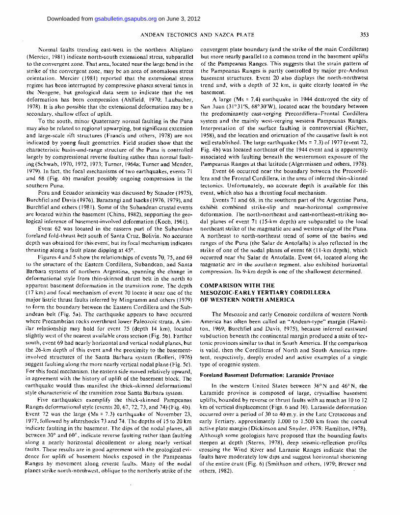
Tectonics over the Flat-subducted Slab: Pampeanas Ranges, Precordillera and Frontal Cordillera (28°S-33°S) . In sharp con-trast to thin-skinned thrust ing to the north and west, the foreland f rom 28° S to 33° S is domina ted by a broad region of crystalline basement uplifts in the Pampeanas Ranges (Fig. 4). These massive mounta in blocks commonly reach 2 to 4 km and locally 6 km elevation, with intervening broad , flat plains at less than 1 km elevation. The ranges, often 75 to 100 km long and 25 to 75 km wide, are uplifted on nor th- to nor th -nor thwes t - t r end ing reverse faults that dip abou t 60° beneath the uplifts (Gordillo and Lenci-nas, 1979; Caminos , 1979b; Lucero M „ 1979; Flores, 1979; Criado Roque and others, 1981). Vertical throws of at least 6 km separate the mounta in blocks f rom the intervening broad basins. The faults place Precambr ian and Paleozoic crystalline basement rocks over upper Cenozoic strata, with associated d rag folds (Fig. 6) (Gordil lo and Lencinas, 1979). Principal deformat ion of the Pampeanas Ranges is poorly dated, but it is thought to be Pliocene and Pleisto-cene in age (Gordil lo and Lencinas, 1979; Lucero M., 1979; Cami-nos, 1979b; Flores, 1979). Ear thquake focal mechanisms indicate active compression in the region, with fault planes apparent ly dip-ping 40° to 60°.
To the west, the Precordillera and Frontal Cordillera (Fig. 4) appear to be a nar row Neogene to Quate rnary thin-skinned thrust belt. The complex pre-Andean structural history is recorded in a Paleozoic sequence, including oceanic slices and late Paleozoic bathol i ths (Fu rque and Cuerda , 1979; Caminos , 1979a). The Prin-cipal Cordillera, in the southwest part of this segment, is dominated by Mesozoic volcanic and sedimentary sequences (Yrigoyen, 1979). West-dipping reverse faults , locally observed to be low angle, were active in the mid-late Miocene along the boundary between the Principal Cordil lera and Frontal Cordillera. A set of imbricate west-dipping reverse faults separat ing the Fronta l Cordil lera and Precordillera developed dur ing the late Pliocene to early Pleisto-cene, indicating eastward-migrat ing thrust ing (Gonzalez Bonorino, 1950; Caminos , 1979a). In the Precordillera, lower Paleozoic rocks locally overlie Ter t iary on 40° to 50° west-dipping reverse faults, and Holocene uplift cont inues (Furque and Cuerda , 1979). In the eas ternmost Precordil lera, reverse faults verge to the west (Ortiz and Zambrano , 1981).
Transition Zone Overlying Inferred 30°-dipping Slab (23° S -28° S). The foreland of the t ransi t ion zone is deformed by large, broad, p redominant ly west-verging folds cored by lower Paleozoic rocks and bounded by reverse faul ts on one or both sides (Santa Barbara system) (Fig. 7). The Eastern Cordil lera of the transit ion zone conta ins thick deposi ts of Cretaceous red beds lying uncon-formably on low-grade metasediments of the Precambr ian-Cam-brian Puncoviscana Basin. A nor thern wedge of Sierras Pampeanas crystalline basement uplifts consti tutes a third part of the transit ion zone ( M o n , 1972, 1976a; Mon and Urdaneta , 1972; Turner and Mon, 1979; Reyes and Salfity, 1973; Rolleri, 1976; Allmendinger and others, 1981). In all of these regions, a significant component of strike-slip faul t ing is evident, with left-lateral sense on northwest-t rending faults and right-lateral sense on eas t -nor theas t - t rending faults (Baldis and others, 1976; Ramos , 1977; Salfity, 1979). In the Puna , Miocene to Quate rnary volcanic rocks coincide with several of these transverse structural zones.
The s tructural style of the transit ion zone, with characteristics of the thrus t belt to the nor th and of the basement uplifts to the south, is partly controlled by the local paleogeography. Well-defined areas of thrust ing are localized in Cretaceous basin fill, whereas steeper reverse faul t ing coincides with relative sedimentary thins. The t ransi t ion f r o m deepest exposures in the nor th of Pre-cambr ian greenschist-facies flysch to a southern , mechanically stiff
basement of gneisses and intrusives corresponds to a transit ion f rom generally low-angle to high-angle reverse faults (Mon , 1972; Allmendinger and others, 1981).
The transi t ional region terminates southward in a diffuse, nor theas t - t rending zone known as the T u c u m a n , Hualf in, and Aconqui ja l ineaments ( M o n , 1976a, 1976b; Ramos , 1977; Salfity, 1979; Turne r and Mon, 1979). This zone appears to be one of distributed right-lateral shearing rather than strike-slip fault ing a long a single faul t . Ordovician l i tho-tectonic assemblages are dis-placed across this zone, but the age and significance of the apparen t offset is not yet known. The zone also coincides with the southern boundary of the Puna (Fig. 4).
The high basins of the Puna are located between the active volcanic axis and the transi t ional foreland province just described (Fig. 1 and 4). At the western edgeof the Puna , the main volcanic axis changes t rend sharply at 23.5°S. To the nor th the axis t rends nor th-nor thwes t , but to the south, it t rends nor th-nor theas t . Far ther south, the axis changes to nor th-south (Fig. 4). This jog fo rms the eastern bounda ry of the lower (2.3 km) Atacama basin of Chile. The Alt iplano and Puna "bounda ry" lies east of this jog. A part icularly extensive east-west zone of Miocene-Quaternary vol-canics and a pronounced westward encroachment of Atlantic Ocean drainage occur at the Al t ip lano-Puna boundary .
Unlike the Alt iplano, the Puna is characterized by many small in te rmontane basins and mounta in blocks with nor th-south to nor th -nor theas t - sou th - sou thwes t t rends and 1 to 2 km relief. Ranges are probably bounded by high-angle reverse faults that were active in the Neogene, de fo rming units as young as abou t 9 to 10 m.y. old (Schwab, 1970, 1972, 1973; Turner and Mendez, 1979; Coira and others, 1982).
Sou the rn Region over 30° -d ipping Subduc ted Segment (33°S-38°S) . Whereas a main subducted plate segment boundary is at 33° S, the pronounced change in foreland geology occurs at abou t 34°30'S (Fig. 4). Between 33° S and 34°30'S, deformat ion pat terns are typical of, but less developed than , the Precordillera and the Pampeanas Ranges to the nor th . The large morphos t ruc -tural blocks of the Pampeanas Ranges cease at 33°S, but minor exposures of similar crystalline basement persist to the south (Cr iado Roque and Ibanez, 1979). Active gentle folding of Neogene strata is reported a long strike of the Precordil lera (Regairaz and Videla Leanie, 1968) and seismic-reflection da ta reveal west-dipping thrusts and eastward-vergent folds (Bettini, 1980). The Frontal Cordil lera Neogene s tructural province cont inues to abou t 34°30'S. Early Miocene volcanism occurred in the western Andes, and Mid-dle to late Miocene magmat i sm and Qua te rnary volcanics are c o m m o n in the Principal Cordil lera.
In contras t , south of 34°30'S, there are voluminous Quater -nary volcanics extending f rom the Principal Cordil lera to more than 100 km east of the Andes foothills (Fig. 4). Little is known abou t the chemistry or tectonic affinity of these basalts and ande-sites, which fo rm several p rominen t volcanic centers with as much as 3 km relief above the sur rounding plains. Mid-Tert iary folding and faul t ing and Miocene folding accompanied by significant salt tectonics are reported in the Principal Cordillera, and younger fold-ing and thrus t ing are likely. In the broad volcanic fore land, there is little reported evidence of pos t -Miocene compression; minor fault-ing and gentle arching of s trata are suggested ( M o m b r u and Uliana, 1978), The c o m m o n southeast- to-east or ientat ion of these struc-tures suggests control by older basement trends.
The significant s t ructural break at 34°30'S apparent ly coin-cides with the nor thern limit of the impor tan t Mesozoic Neuquen basin. Late Paleozoic-ear ly Mesozoic mounta in building may also have created a prominent nor thwest- t rending structural grain that
on June 3, 2012gsabulletin.gsapubs.orgDownloaded from

350 JORDAN AND OTHERS
KEY
t ^ * " Reverse or thrust f au l t u-n—rf" Steep fau l t o
An t i c l i ne w / plunge + vergence
Syncl ine w / plunge
E boundary of Puna
|v vv| Neogene volcanics
Kv 'Cr Crysta l l ine basement
^ Earthquake epicenter
100 KM
Figure 7. Generalized tectonic map of transition zone and adjacent regions of northwest Argentina. Crystalline basement exposures indicate the northern Pampeanas Ranges. The Aconquija/Tucuman lineaments, shown by heavy arrows, are interpreted as a broad zone of right-lateral shearing. Unpatterned areas are metamorphics, Phanerozoic sedimentary rocks, and intrusives. The Puna has extensive volcanic cover, west of dashed drainage divide. Structures not shown in Puna except for prominent west-verging folds in Tertiary strata. EC, Eastern Cordillera; SA, Subandean belt; SB, Santa Barbara system; J, Jujuy; S, Salta; T, Tucuman. Section lines a, b, and c refer to Figure 5. Focal mechanisms are referred to in text by number, with epicenters shown by nearby filled circles. The Argentina-Bolivia international boundary is shown at the top of the figure. Data from analysis of L A N D S A T imagery, field observations by the authors, and maps by Gonzales Bonorino (1972), Maisonave (1979), Ruiz Huidobro (1968,1972, and 1975), Turner (1964a and 1964b, 1967, 1971, and 1973), and Vilela and Garcia (1978).
intersects the modern Andes near 34°30'S (Dalziel and Elliott, 1982).
Comparison to Peru
The tectonic f r amework of both Andean and older orogenic phases in Peru and Bolivia is described in numerous recent geologi-
cal studies (Audebaud and others , 1973; Megard , 1978; Marocco , 1978; Laubacher , 1978; Da lmayrac , 1978; Mart inez and Tornasi , 1978; Da lmayrac and others, 1980a). Above ano ther nearly hori-zontal segment of the Benioff zone in central Peru ( Fig. 1, 2, and 3), Neogene de fo rma t ion in the hinter land and foreland is character -ized by open cylindrical and locally asymmetr ic folding, monocl inal
on June 3, 2012gsabulletin.gsapubs.orgDownloaded from
ANDEAN TECTONICS AND NAZCA PLATE 351
flexuring, and northeast-vergent reverse faults (reported dips between 50° and 80°). Locally, basement-cored uplifts are bounded on the southwest side by west-verging reverse faults ( H a m and Her-rera, 1963; Megard, 1978). Basement involvement in foreland deformat ion in Peru appears most pronounced between about 7°S and 13°S ( H a m and Herrera, 1963; Bellido and others, 1972; Mar-tinez and Tomasi , 1978).
However, foreland basement deformat ion above the Peruvian f lat-subducted slab is probably not as extreme as over the Chile-Argentina flat-slab ( H a m and Herrera, 1963; Megard , 1978; Gor-dillo and Lencinas, 1979; Caminos, 1979b). This difference may be due to subtle differences in subduct ion geometry, or may imply that the hor izonta l -subduct ion geometry in Chile-Argentina is older than in Peru. Perhaps, if present' subduct ion geometries continue, Peruvian foreland uplifts will become similar to the present Pam-peanas Ranges. Alternatively, the differences in the two foreland provinces may partly or largely reflect differences in the thickness or character of the South American crust, rather than differences in subduct ion history.
Indirect evidence for the history of the flat subduct ion comes f rom the volcanic age sequence in the magmat ic arc. In Peru, intense volcanic and plutonic activity f r o m 8 to 11 m.y. B.P. was followed by waning but still significant activity until 5 m.y. B.P. (Noble and McKee, 1977). Therefore, the Peruvian flat-slab geome-try was probably fully developed by abou t 5 m.y. B.P. Over the Chile-Argentina flat-slab, the young volcanic history is less con-strained. In Chile, only minor amount s of Miocene and Pliocene volcanics have been mapped between 28°S and 33°S (Fuller, 1968). In Argent ina, volumetrically minor volcanics, locally with 16- to 20-m.y. K-Ar dates and elsewhere assigned Pliocene and Pleisto-cene ages, are scattered across the f lat-subducting region (Aparicio, 1975; Leveratto, 1976).
CRUSTAL E A R T H Q U A K E S A N D ACTIVE TECTONICS OF THE UPPER PLATE
Shallow ear thquakes in the continental crust of western South America manifest ongoing tectonic activity. Chinn (1982) and Chinn and Isacks (unpub. da ta) determined new focal mechanism solutions for shallow ear thquakes in the Andean crust, updat ing the work of S tauder (1973, 1975). They also report accurate focal depths for many of the ear thquakes large enough to obtain focal-mechanism solutions. In this paper, their da ta and published ear th-quake locations are integrated with Neogene tectonic informat ion.
Areal Distribution
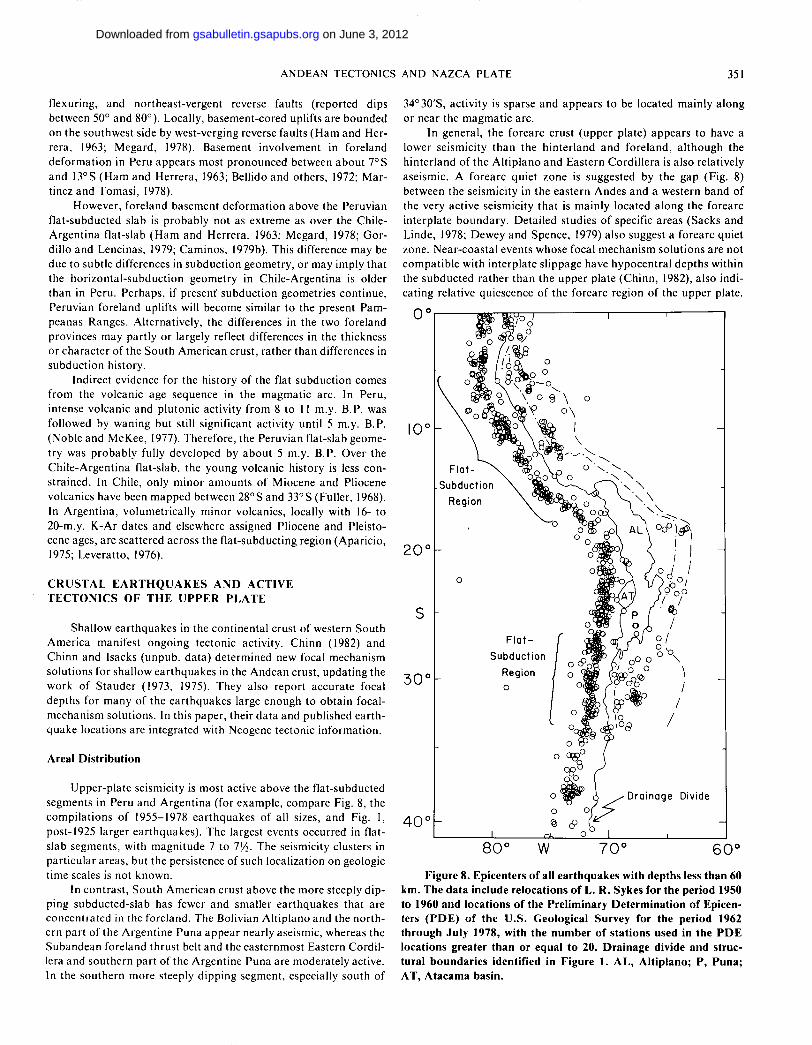
Upper-plate seismicity is most active above the f lat-subducted segments in Peru and Argent ina (for example, compare Fig. 8, the compi la t ions of 1955-1978 ear thquakes of all sizes, and Fig. 1, post-1925 larger ear thquakes) . The largest events occurred in flat-slab segments, with magni tude 7 to IVi- The seismicity clusters in part icular areas, but the persistence of such localization on geologic time scales is not known.
In cont ras t , South American crust above the more steeply dip-ping subducted-slab has fewer and smaller ear thquakes that are concentrated in the foreland. The Bolivian Alt iplano and the nor th-ern part of the Argent ine Puna appear nearly aseismic, whereas the Subandean foreland thrust belt and the easternmost Eastern Cordil-lera and southern part of the Argentine Puna are moderately active. In the southern more steeply dipping segment, especially south of
34°30'S, activity is sparse and appears to be located mainly a long or near the magmat ic arc.
In general, the forearc crust (upper plate) appears to have a lower seismicity than the hinter land and fore land, a l though the hinter land of the Al t ip lano and Eastern Cordil lera is also relatively aseismic. A forearc quiet zone is suggested by the gap (Fig. 8) between the seismicity in the eastern Andes and a western band of the very active seismicity that is mainly located a long the forearc interplate boundary . Detailed studies of specific areas (Sacks and Linde, 1978; Dewey and Spence, 1979) also suggest a forearc quiet zone. Near-coastal events whose focal mechanism solut ions are not compat ible with interplate slippage have hypocentral depths within the subducted rather than the upper plate (Chinn, 1982), also indi-cating relative quiescence of the forearc region of the upper plate.
Figure 8. Epicenters of all earthquakes with depths less than 60 km. The data include relocations of L. R. Sykes for the period 1950 to 1960 and locations of the Preliminary Determination of Epicen-ters (PDE) of the U.S. Geological Survey for the period 1962 through July 1978, with the number of stations used in the P D E locations greater than or equal to 20. Drainage divide and struc-tural boundaries identified in Figure 1. AL, Altiplano; P, Puna; AT, Atacama basin.
on June 3, 2012gsabulletin.gsapubs.orgDownloaded from

352 JORDAN AND OTHERS
SOUTH AMERICA
NUMBER
FORE-ARC DESCENDING
P L A T E
I N T E R P L A T E THRUST
I N T R A P L A T E BACK-ARC NON-THRUST OVERRIDING
P L A T E
Figure 9. Distribution of well-determined focal depths of shal-low earthquakes in western South America. Depths determined by comparisons of synthetic and observed P-wave forms recorded by long-period seismographs of the W W S S N . Solid bars are in-plate compression; open bars are in-plate extension; diagonal lines are interplate thrust; and X, none of the preceding. These interpreta-tions are based on the orientation of focal mechanism solutions. The four plots represent tectonic groupings according to location. The "forearc" include events mainly near the trench, while the "intraplate non-thrust" include events located near the interplate boundary (from Chinn, 1982).
Yamashina and others (1978) present evidence that a quiescent forearc zone is a general feature of upper-plate seismicity in subduc-tion zones.
Focal-Mechanism Solutions: Predominance of Horizontal Compression
A s t rong hor izonta l east-west g rouping of the " P " or compres-sional axes of the focal-mechanism solutions exists for the upper-plate ea r thquakes within the entire region f rom Ecuador to Argent ina (Fig. 1) and in the foreland and Eastern Cordil lera of Colombia (Pennington , 1981). Al though dip-slip solutions predom-inate, strike-slip or ientat ions are found in parts of Peru, Ecuador , and Colombia where the trend of the Andes is most transverse to the regional stress or ientat ion. The average stress direction (obta ined f r o m the focal -mechanism da ta ) and the inferred direc-tion of relative mot ion across the N a z c a - S o u t h American plate b o u n d a r y are subparal le l (Chase, 1978; Minster and J o r d a n , 1978). This coincidence suggests that the over-all convergence of the two plates is an impor tan t de te rminant of the stress within the upper plate in cont ras t to more localized and variable effects of uplift , magmat ic intrusion, or other upper-plate processes.
Focal-mechanism solutions of several ea r thquakes located a long the magmat i c arc of Chi le-Argent ina reflect the over-all east-west compressive stress (Fig. 4b, events 64 and 71). The one ear th-quake studied by Chinn (1982) that was possibly located in the forearc upper plate (event 63, Fig. 4b) had a combined thrust and strike-slip solut ion with a compressive axis oriented obliquely (nor thwest -southeas t ) to the trend of the subduct ion zone. How-ever, the 30-km depth places it ambiguously close to the plate boundary . It was also located directly below the surface trace of the
A t a c a m a faul t (Arabasz , 1971), but neither of the two nodal planes can be easily associated with this fault .
Depths
Defo rma t ion at middle- and upper-crusta l dep ths is d e m o n -strated by reliable de te rmina t ions of depths of crustal ea r thquakes by analyses of long period P, pP, and sP phases (Chinn, 1982; Fig. 9). Most depths are between 10 and 25 km, but a significant minori ty occur at depths of 25 to 35 km; the deepest de terminat ion is 36 km for an event in the Ecuador ian Subandean zone. Depths of many of the events are clearly below the sedimentary section and indicate compressional de format ion of the basement . Specific examples , especially for Bolivia and Argent ina , are discussed below.
Relationships of Seismicity to Late Cenozoic Deformation of the Upper Plate
Compar i son of the dis t r ibut ions of seismicity and of late Neo-gene crustal de fo rma t ion indicates a correlat ion between the two phenomena . In the areas of significant seismicity characterized by focal mechanism solut ions with hor izontal compressive axes, the latest Neogene s tructures are domina ted by reverse faul t ing and fo ld ing indicative of impor t an t crustal shor tening. In cont ras t , the relatively aseismic areas, including the forearc zone, the Alt iplano, and par ts of the Bolivian Eastern Cordil lera and the Argent ine Puna , are character ized by a relatively stable neotectonic regime or by one that appears to be domina ted by relative vertical move-ments . As noted above, the fo rearc regions in the flat-slab areas in Peru and Chile appea r to be relatively stable, a l though vertical movements and tilting of blocks may occur. In the forearc zones above the more steeply d ipping subduct ing slabs, the Longi tudinal or Cent ra l Valley and associated coastal ranges exhibit different ial vertical movements , but the type and extent (or even the existence) of Neogene horizontal de fo rma t ion are not well established.
Evidence for extensional stress is reported for the Peruvian Cordil lera Blanca (Dalmayrac , 1974; Yonekura and others, 1979; D a l m a y r a c and Molnar , 1981), for the nor the rn Al t ip lano and par t of the Eastern Cordil lera of nor the rn Bolivia and southern Peru (Megard and Philip, 1976; Mercier, 1981), and for the southern b o u n d a r y of the Puna (Turner , 1967). However , in none of these cases is there clear evidence for large a m o u n t s of crustal extension, and in each case there is an ambiguous but close relat ionship to crustal compression.
The spectacular no rmal faul t ing west of the Cordil lera Blanca (Fig. 3a) is apparen t ly related to the uplift of the very young ba tho -lith fo rming the Cordil lera (ages as young as 2.7 m.y.; Stewart and others , 1974). One of the largest known crustal ea r thquakes , the Ancash ea r thquake of 1946, was located east of the Cordil lera Blanca. It p roduced one of the few published cases of possible surface fau l t ing in the Andes and was interpreted as no rma l faul t -ing by Silgado (1951) and Richter (1958). However, Megard and Philip (1976) emphasize evidence found within the bathol i th itself for compressive de fo rmat ion . Dalmayrac and Molnar (1981) emphasize the extensional stress implied by the normal fault ing, but they consider the extension to be an effect of uplift and crustal thickening caused by the more pervasive and impor tan t crustal shor tening manifested in the Eastern Cordil lera and S u b a n d e a n zone.
on June 3, 2012gsabulletin.gsapubs.orgDownloaded from
ANDEAN TECTONICS AND NAZCA PLATE 353
Normal faults t rending east-west in the nor thern Altiplano (Mercier, 1981) indicate nor th-south extensional stress, subparallel to the convergent zone. That area, located near the large bend in the strike of the convergent zone, may be an area of anomalous stress or ienta t ion. Mercier (1981) reported that the extensional stress regime has been interrupted by compressive phases several times in the Neogene, but geological da ta seem to indicate that the net de format ion has been compression (Ahlfield, 1970; Laubacher , 1978). It is also possible that the extensional deformat ion may be a secondary, shallow effect of uplift .
To the south, minor Quaternary normal fault ing in the Puna may also be related to regional upwarping, but significant extension and large-scale rift s t ructures (Francis and others, 1978) are not indicated by young fault geometries. Field studies show that the characteristic basin-and-range structure of the Puna is controlled largely by compressional reverse fault ing rather than normal fault-ing (Schwab, 1970, 1972, 1973; Turner , 1964a; Turner and Mendez, 1979). In fact , the focal mechanisms of two ear thquakes , events 71 and 68 (Fig. 4b) manifest possibly ongoing compression in the southern Puna.
Peru and Ecuador seismicity was discussed by Stauder (1975), Burchf ie land Davis(1976), Barazangi and Isacks(1976, 1979), and Burchfiel and others (1981). Some of the Subandean crustal events are located within the basement (Chinn, 1982), support ing the geo-logical inference of basement-involved deformat ion (Koch, 1961).
Event 62 was located in the eastern part of the Subandean foreland fold- thrust belt south of Santa Cruz, Bolivia. No accurate depth was obtained for this event, but its focal mechanism indicates thrust ing a long a fault plane dipping at 45°.
Figures 4 and 5 show the relat ionships of events 70, 75, and 69 to the s t ructure of the Eastern Cordil lera, Subandean , and Santa Barbara systems of nor thern Argentina, spanning the change in deformat iona l style f rom thin-skinned thrust belt in the nor th to appa ren t basement de format ion in the transit ion zone. The depth (17 km) and focal mechanism of event 70 locate it near one of the ma jo r listric thrust faults inferred by Mingramm and others (1979) to fo rm the boundary between the Eastern Cordillera and the Sub-andean belt (Fig. 5a). The ea r thquake appears to have occurred where Precambr ian rocks overthrust lower Paleozoic strata. A sim-ilar relat ionship may hold for event 75 (depth 14 km), located slightly west of the nearest available cross section (Fig. 5b). Far ther south, event 69 had nearly horizontal and vertical nodal planes, but the 26-km depth of this event and the proximity to the basement-involved structures of the Santa Barbara system (Rolleri , 1976) suggest fault ing along the more nearly vertical nodal plane (Fig. 5c). For this focal mechanism, the eastern side moved relatively upward, in agreement with the history of uplift of the basement block. The ea r thquake would thus manifest the thick-skinned deformat iona l style characteristic of the transit ion zone Santa Barbara system.
Five ear thquakes exemplify the thick-skinned Pampeanas Ranges deformat iona l style (events 20, 67, 72, 73, and 74) (Fig. 4b). Event 72 was the large (Ms = 7.3) ea r thquake of November 23, 1977, followed by af te rshocks 73 and 74. The depths of 15 to 20 km indicate faul t ing in the basement . The dips of the nodal planes, all between 30° and 60°, indicate reverse faul t ing rather than fault ing a long a nearly horizontal décollement or along nearly vertical faults. These results are in good agreement with the geological evi-dence for uplift of basement blocks exposed in the Pampeanas Ranges by movement a long reverse faults. Many of the nodal planes strike nor th-nor thwest , oblique to the northerly strike of the
convergent plate bounda ry (and the strike of the main Cordil leras) but more nearly parallel to a c o m m o n trend in the basement uplifts of the Pampeanas Ranges. This suggests that the strain pattern of the P a m p e a n a s Ranges is partly control led by m a j o r pre-Andean basement structures. Event 20 also displays the nor th-nor thwest trend and , with a depth of 32 km, is quite clearly located in the basement.
A large (Ms = 7.4) ea r thquake in 1944 destroyed the city of San J u a n (31°31'S, 68°30'W), located near the boundary between the predominant ly east-verging Precord i l le ra-Fronta l Cordillera system and the mainly west-verging western Pampeanas Ranges. In terpre ta t ion of the surface faul t ing is controversial (Richter , 1958), and the location and orientat ion of the causative fault is not well established. The large ea r thquake (Ms = 7.3) of 1977 (event 72, Fig. 4b) was located nor theas t of the 1944 event and is apparent ly associated with faul t ing beneath the westernmost exposure of the Pampeanas Ranges at that lat i tude (Algermissen and others, 1978).
Event 66 occurred near the bounda ry between the Precordil-lera and the Fronta l Cordil lera, in the area of inferred thin-skinned tectonics. Unfor tunate ly , no accura te depth is available for this event, which also has a thrust ing focal mechanism.
Events 71 and 68, in the southern part of the Argent ine Puna , exhibit combined strike-slip and near-horizontal compressive de fo rmat ion . The nor th-nor theas t and eas t -nor theas t -s t r ik ing no-dal planes of event 71 (15-km depth) are subparallel to the local nor theas t strike of the magmat ic arc and western edge of the Puna . A northeast to nor th-nor theas t trend of some of the basins and ranges of the Puna (the Salar de Antofa l la ) is also reflected in the strike of one of the nodal planes of event 68 (11-km depth) , which occurred near the Salar de Antofal la . Event 64, located a long the magmat ic arc in the southern segment, also exhibited hor izontal compression. Its 9-km depth is one of the shallowest determined.
C O M P A R I S O N WITH THE MESOZOIC-EARLY TERTIARY CORDILLERA OF WESTERN NORTH AMERICA
The Mesozoic and early Cenozoic cordillera of western Nor th America has of ten been called an "Andean- type" margin (Hamil -ton , 1969; Burchfiel and Davis, 1975), because inferred eastward subduct ion beneath the cont inental margin produced a suite of tec-tonic provinces similar to tha t in South America. If the compar i son is valid, then the Cordi l leras of Nor th and South America repre-sent, respectively, deeply eroded and active examples of a single type of orogenic system.
Foreland Basement Deformation: Laramide Province
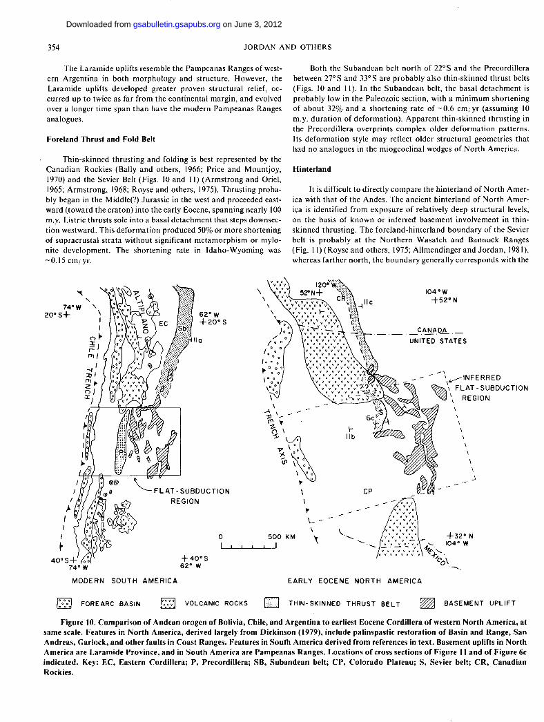
In the western United States between 36° N and 46° N, the Laramide province is composed of large, crystalline basement uplifts, bounded by reverse or thrust faults with as much as 10 to 12 km of vertical displacement (Figs. 6 and 10). Laramide deformat ion occurred over a period of 30 to 40 m.y. in the Late Cretaceous and early Tert iary, approximate ly 1,000 to 1,500 km f rom the coeval active plate margin (Dickinson and Snyder , 1978; Hamil ton , 1978). Al though some geologists have proposed that the bounding faults steepen at depth (Sterns, 1978), deep seismic-reflection profiles crossing the Wind River and Laramie Ranges indicate that the faults have moderate ly low dips and suggest hor izontal shortening of the entire crust (Fig. 6) (Smi thson and others, 1979; Brewer and others, 1982).
on June 3, 2012gsabulletin.gsapubs.orgDownloaded from
354 JORDAN AND OTHERS
The Laramide uplifts resemble the Pampeanas Ranges of west-ern Argent ina in both morphology and structure. However, the Laramide uplifts developed greater proven s tructural relief, oc-curred up to twice as far f rom the cont inental margin, and evolved over a longer t ime span than have the modern Pampeanas Ranges analogues.
Foreland Thrust and Fold Belt
Thin-skinned thrust ing and folding is best represented by the Canad ian Rockies (Bally and others , 1966; Price and Mount joy , 1970) and the Sevier Belt (Figs. 10 and 11) (Armst rong and Oriel, 1965; Armst rong , 1968; Royse and others, 1975). Thrust ing proba-bly began in the Middle(?) Jurassic in the west and proceeded east-ward ( toward the cra ton) into the early Eocene, spanning nearly 100 m.y. Listric thrusts sole into a basal de tachment that steps downsec-tion westward. This de fo rmat ion produced 50% or more shortening of supracrusta l strata wi thout significant me tamorph i sm or mylo-nite development . The shor tening rate in Idaho-Wyoming was ~0.15 cm/ yr.
Both the Subandean belt nor th of 22° S and the Precordillera between 27° S and 33° S are p robab ly also thin-skinned thrust belts (Figs. 10 and 11). In the S u b a n d e a n belt, the basal de tachment is probably low in the Paleozoic section, with a min imum shor tening of abou t 32% and a shor tening rate of ~0 .6 c m / y r (assuming 10 m.y. du ra t ion of de format ion) . Apparen t thin-skinned thrust ing in the Precordil lera overprints complex older de fo rmat ion pat terns . Its de fo rma t ion style may reflect older s t ructural geometries that had no analogues in the miogeoclinal wedges of Nor th America.
Hinterland
It is difficult to directly compare the hinterland of Nor th Amer-ica with tha t of the Andes. The ancient hinterland of Nor th Amer-ica is identified f r o m exposure of relatively deep s t ructural levels, on the basis of known or inferred basement involvement in thin-skinned thrust ing. The fore land-hin ter land bounda ry of the Sevier belt is p robably at the Nor the rn Wasatch and Bannock Ranges (Fig. l l ) ( R o y s e a n d others, 1975; Allmendinger and J o r d a n , 1981), whereas fa r ther nor th , the bounda ry generally corresponds with the
l l y j FOREARC BASIN [Y.Yj VOLCANIC ROCKS j | THIN-SKINNED THRUST B E L T BASEMENT U P L I F T
Figure 10. Comparison of Andean orogen of Bolivia, Chile, and Argentina to earliest Eocene Cordillera of western North America, at same scale. Features in North America, derived largely from Dickinson (1979), include palinspastic restoration of Basin and Range, San Andreas, Garlock, and other faults in Coast Ranges. Features in South America derived from references in text. Basement uplifts in North America are Laramide Province, and in South America are Pampeanas Ranges. Locations of cross sections of Figure 11 and of Figure 6c indicated. Key: EC, Eastern Cordillera; P, Precordillera; SB, Subandean belt; CP, Colorado Plateau; S, Sevier belt; CR, Canadian Rockies.
on June 3, 2012gsabulletin.gsapubs.orgDownloaded from

ANDEAN TECTONICS AND NAZCA PLATE 355
Rocky Mounta in Trench (Price and Moun t joy , 1970; Brown, 1978; Harrison and others, 1980).
The modern Andean hinterland was deformed a few million years ago by an orogenic event that migrated toward the craton, but the hinterland is now inactive, with deep structure neither exposed nor revealed by ear thquakes . The sole fault of the Subandean belt is believed to step downward to the west at the Eastern Cord i l l e ra -Subandean belt boundary , suggesting that the Eastern Cordillera and Al t ip lano-Puna are "hinter land."
In western North America nor th of 39° N, a linear belt of dynamically metamorphosed greenschist- to amphiboli te-facies rocks is widely developed in the hinterland at the eastern fringes of the Mesozoic magmat ic arc. The belt was probably first deformed dur ing or just prior to Mesozoic de format ion in the foreland (Fig. 11) (DeWit t , 1980; Allmendinger and J o r d a n , 1981). In South America, no linear me tamorph ic belt related to Neogene deforma-tion is known. However, one would expect to find such a belt at depth under the eastern Al t ip lano-Puna.
Magmatic Arc
The Jurass ic and Cretaceous magmat ic arc was well developed a long the entire length of the Nor th American Cordil lera and is presently expressed as a suite of calc-alkaline intrusives (Davis and others , 1978; Miller and Bradfish, 1980). However, in the Late Cre-taceous and early Tert iary (80 to 40 m.y. B.P.), magmat ism ceased in the region west of the concurrent ly forming Laramide uplifts (Fig. 10), and , nor th and south of that cor r idor , the axis of igneous activity swept f r o m west to east, and then returned west (Dickinson and Snyder, 1978; Cross and Pilger, 1978). This magmat ic trend has been explained as a result of shal lowing in the d ip of the eastward subducted slab, perhaps triggering the t ransi t ion f rom thin-skinned to thick-skinned foreland de fo rmat ion far ther east (Lipman and others, 1971; Burchfiel and Davis, 1975; Coney, 1976; Dickinson and Snyder, 1978).
In Chile and Argent ina , south of 33°S and nor th of 28°S, the volcanic zone became anomalous ly wide in the Miocene. In the
ANDES 2 2 ° 4 5 ' S
PUNA - ALTIPLANO EASTERN CORDILLERA SUBANDEAN BELT
S E V I E R B E L T
EASTERN MARGIN ALBION Ji PLUTONIC BELT META. COMPLEX WASATCH RA. IDAHO - WYOMING THRUST BELT
CANADIAN ROCKIES
SHUSWAP META. COMPLEX
ROCKY MT.
SELKIRK FAN TRENCH MAIN RA. FOOTHILLS
0 5 0 K M 1 1 j 1 i i
Figure 11. Comparison, at same scale, of cross sections of (a) eastern Andes in northernmost Argentina, (b) Sevier belt of Utah-Idaho-Wyoming, and (c) Canadian Rocky Mountains thrust belt. Section locations shown in Figure 10. Note similarities in width of foreland thrust belt, distance between magmatic arc and foreland, positions of metamorphic complexes, and implications for position of possible metamorphic complexes in the Andes. Compiled and simplified from Mingramm and others (1979), Turner and Mendez (1979), Turner and Mon (1979), Royse and others (1975), Allmendinger and Jordan (1981), Price and Mountjoy (1970), and Brown (1981).
on June 3, 2012gsabulletin.gsapubs.orgDownloaded from

356 JORDAN AND OTHERS
intervening region, there was little volcanism dur ing the Plio-Qua te rnary uplift of the Pampeanas basement blocks. The modern spatial gap in volcanism correlates with the extent of the nearly hor izonta l Benioff zone. Thus in the Andes and the Nor th Ameri-can Cordil lera, thick-skinned foreland deformat ion and magmat ic gaps are coincident and are inferred to be related to nearly horizon-tal subduct ion .
Forearc Region
Forearc basins in western Nor th America, generally repre-sented by the Great Valley of Cal i fornia and related basins fa r ther nor th , were best developed in the Cretaceous but persisted through the Eocene (Fig. 10) (Dickinson, 1979). The nor th- t rending forearc basins, with volcaniclastic sediment fill, were separated f rom the Franciscan subduct ion complex to the west by an east-dipping ma jo r thrus t fault (Ingersoll, 1978). Par ts of the forearc region in western Nor th America dur ing the Mesozoic and Cenozoic were the sites of extensive accret ion of island-arc f ragments and exotic ter-ranes with dis tant affinit ies (Davis and others, 1978; Coney and others, 1980).
In Chile, na r row linear basins of fshore may represent poorly defined forearc basins (Schweller and Kulm, 1978). The Central (Longi tudinal ) Valley of Chile might also be interpreted as an incompletely filled forearc basin, a l though it seems to occur within cont inental crust ("intra-massif forearc basin" of Dickinson and Seely, 1979). In the Andes , Paleozoic accret ion may have been extensive, but, in contras t with Nor th America, there is little if any f irm geologic evidence for plate-margin accret ion of exotic terranes dur ing the Mesozoic-Cenozoic Andean orogeny.
Transition along Strike
Foreland s t ructure in western Nor th America changes mark -edly a long str ike between 44° N and 47° N, between the Sevier and Laramide belts to the south and the Mon tana Disturbed Belt and Canad i an Rockies to the nor th (King, 1969) (Fig. 10). Transverse-t rending strike-slip and oblique-slip faults occur in a region of com-plex s t ructural geometry. Some details of the southern part of the t ransi t ion are obscured by younger volcanic materials. Similarly, in the Andean t ransi t ion zone, Pampeanas and Subandean structures apparen t ly converge, strike-slip faul t ing and oroclinal f lexuring may be impor tan t , and basement rock types change. Yet, Quater-nary volcanoes suggest that the subducted plate dips steeply, with a geometry similar to areas nor th of the transit ion zone.
The nor thern por t ion of the Nor th American transit ional area coincides approx imate ly with the nor thwest - t rending dextral Lewis and Clark l ineament, which apparent ly originated as an impor tan t bounda ry of the Proterozoic Belt basin and has been subsequently reactivated (Har r i son and others, 1974). The southern limit of this t ransi t ional area is roughly coincident with the Cenozoic Snake River Plain volcanic belt. It is also the sou thern limit of a region of significant Jurassic and younger "suspect terrane" accretion (Davis and others , 1978; Coney and others , 1980). Thus, in the t ransi t ion zones of both Nor th America and the Andes, there are histories of significant cross-strike tectonism. These transit ion zones may pri-marily reflect segmentat ion of the upper l i thospheric plate due to its pre-existing geometry , ra ther than the geometry of the subducted plate.
In summary , the Neogene s t ructure of the central Andes and the Mesozoic-ear ly Cenozoic s t ructure of western Nor th America
are remarkab ly similar in scale and geometry. Fu r the rmore , both orogens exhibit s tructural contro l by varying basin geometry a long strike and s t ructural boundar ies across strike. Some of those paleo-geographic elements coincide with boundar ies of segments of the subducted plates. However, there are impor tan t differences in dura -tion of tectonic events and their strain rates, as well as in accret ion-ary histories a long the two plate margins.
D I S C U S S I O N
Tectonic Characteristics of Major Segments
F o u r cross sections summar ize the tectonic compar i sons and cont ras ts of the ma jo r segments of the Andes in relation to subducted-s lab geometry (Fig. 3). The most consistent correlat ions between s lab-dip and sur face geology are (1) the corre la t ion of f la t -subduct ion with magmat ic nulls and basement-involved fore-land de fo rma t ion (Figs. 3A and 3C), and (2) the associat ion of s teep-subduct ion with active volcanic arc segments and forearc con-tinental basins (Figs. 3B and 3D). Other pat terns of crustal defor -ma t ion are of regional tectonic impor tance but are not equally well developed in all segments with equal slab-dip. In all four segments, the eas tward extent of the Benioff zone is approx imate ly coincident with the eastern limits of p robab le basement de fo rma t ion of the upper plate (Fig. 3); the thin-skinned foreland fold- thrust belt of Bolivia is located well eastward of the inclined seismic zone.
Al though both the Peru and Chile-Argent ina flat-slabs have basement- involved de fo rma t ion in the fore land, the degree of struc-tural relief is drastically di f ferent and may depend on the dura t ion of f la t -subduct ion. Noble and McKee (1977) related the Pliocene expi ra t ion of the magmat ic arc in Peru to the development of flat-subduc t ion there. Available radiometr ic da t ing between 27°S and 33°S (Leverat to , 1976) indicates tha t the flat-slab conf igura t ion existed for 10 to 15 m.y., much longer than in Peru (and led to more extensive thick-skinned de fo rma t ion of the Pampeanas Ranges). The actual magmat i c history in the sou thern volcanic gap is a key problem for fu ture research.
Back-arc s t ructural dist inctions between two steeply subduct -ing segments are especially striking. Between 15°S and 23° S, the broad A l t i p l ano -Eas t e rn Cordil lera uplift and the S u b a n d e a n thin-skinned thrus t belt are m a j o r features of the Andes. Sou th of 34°30'S, over a similarly d ipping subducted slab, a b u n d a n t basalt at low elevat ions extends f a r east of the volcanic axis, and there is no equivalent of the Al t ip lano-Eas te rn Cordillera uplifts. Al though pa leogeographic differences may cont r ibute to these striking tec-tonic dist inctions, the marked difference in the downdip length of the Benioff zones in the two s teep-subduct ing segments may play a key role. The Neogene volcanic fields south of 34°30'S lie fa r east of the Benioff zone. Whether this magmat ic province is directly related to the subduc t ion process and is ana logous to the widespread magmat i sm of the Alt iplano, or whether it is a regional intra-plate or mant le p h e n o m e n o n only indirectly related to the subduct ion process, is unknown . An int imate relat ionship qf the Al t ip lano to the subduc t ion process is presumed because of the close cor respon-dence of its geomorph ic boundar ies to the magmat ic arc and to the geometry of the descending slab.
A late Cenozoic shallowing of the angle of subduct ion of all the segments beneath western South America might explain why the eastward limits of foreland de fo rmat ion and the intermediate-depth Benioff zone correlate, and why foreland de fo rmat ion is apparen t ly a lmost completely Neogene in age. In fact, the 30° dip of the "steep"
on June 3, 2012gsabulletin.gsapubs.orgDownloaded from
ANDEAN TECTONICS AND NAZCA PLATE 357
segments is quite gentle compared to most subduct ion zones (Isacks and Barazangi, 1977). Foreland de fo rmat ion 700 to 800 km f rom the trench is associated with both flat- and steep-dipping segments of the Nazca plate, except south of 33° S. The large-scale shallowing of the subducted plate might be related to the app roach of the East Pacific spreading center and the decreasing age of the subducted plate (Vlaar and Wortel , 1976; Molnar and Atwater , 1978). How-ever, the segment with the youngest l i thosphere, south of 33°S, is neither the flattest nor does it have significant foreland deforma-tion. Subduc t ion beneath western Nor th America may have also shoaled dur ing the late Mesozoic and early Cenozoic as the Pacific-Faral lon spreading center approached California, thereby account-ing for the analogies between the Andes and western Nor th America.
Coincidence of Subducted and Overriding Plate Segments
There is a clear correspondence between seismologically defined lateral segments in the subducted plate and tectonic seg-ments in the Andes. However, not all shallow crustal segments correlate to separate Benioff zone segments. Between abou t 15°S and 24° S, there is one steeply dipping segment of the subducted Nazca plate, a l though continui ty of the volcanic axis and forearc structures suggests that it cont inues to 27°S or 28°S. However, east of the magmat ic axis, f r om 15°S to 27°S, the geology defines three discrete segments. At 18°S, the coastline and s tructural t rends change abrupt ly , but there is no similarly sharp coincident bend in either the Benioff zone or magmat ic axis (Fig. 1). At about 23°S, the Alt iplano and classical foreland thin-skinned structures on the nor th change to the Puna and variable foreland structures to the south in the t ransi t ion zone. Yet, as is especially clear in a compar i -son of the Puna and Altiplano, the Neogene history of the region f r o m 15°S to 27° S is quite un i form, and it is primarily fault geome-tries that differ . Therefore , the three subsegments expressed in the hinter land and foreland geology f rom 15°S to 27°S are probably inherited f r o m heterogeneities of the cont inental plate, not f rom present plate interactions.
Essentially, more than one type of tectonic segmentat ion may opera te s imultaneously in a Cordi l leran-type mounta in belt. Fore-arc s t ructures and the magmat ic arc may have a s t rong tendency to truly reflect subducted-plate geometry, but foreland structures are probably strongly influenced by both pre-existing crustal geometry and subducted-plate geometry. To identify ancient slab segmenta-tion and dip in an inactive orogen, one must examine the coeval transverse and longitudinal tectonic variations, rather than using one or two of the characteristic features of Figure 3, particularly if only the hinterland and foreland are preserved.
Upper-Plate Stress Distribution
The modern crustal ea r thquake pat terns are sufficiently similar to Plio-Pleistocene deformat ion trends to suggest that existing stress condit ions are a cont inuat ion of those which built the modern Andes. In general, the Andean foreland and locally the magmat ic arc are under east-west hor izontal compression (Fig. 1). Over the s teep-subduct ing slab f rom 15°S to 23°S, the 500-km-wide hinter-land is aseismic, and active brittle deformat ion is mainly expressed as horizontal shortening in the foreland. In contrast , above the nearly horizontal-subducted Nazca plate, ear thquakes indicate east-west horizontal shortening over a wide area east of the forearc region. Stress pat terns in the forearc regions are more complex and possibly extensional at shallow crustal levels. In the wedge-shaped
upper-pla te forearc , the stresses may be substantial ly modif ied, especially at very shallow depths, by geometric effects of convergent plate coupl ing a long the megathrus t plate boundary , such as bend-ing of the plate (Sacks and Linde, 1978; Yamashina and others, 1978). Isostatic and topograph ic effects of crustal thickening or mounta in-bui ld ing processes may also be impor tan t (Dalmayrac and Molnar , 1981).
Models of the driving forces of de fo rmat ion over a steeply subduct ing plate must relate foreland thrust ing and Al t ip lano-Puna uplif t . The history of prolific volcanism suggests that heating and magmat i sm played impor tan t roles in the Al t ip lano-Puna evolu-tion. Model opt ions include (1) crustal volume increase in the Al t ip lano-Puna due to extensive magmat ism that drove shortening at a similar hor izon elsewhere (Hami l ton , 1978; Smith , 1981), and (2) under thrus t ing of the foreland beneath a thin, upper-crustal A l t ip l ano-Puna-Eas te rn Cordil lera plate. To discriminate between these and other al ternative models of Al t ip lano-Puna evolution, quant i f icat ion of the variat ion of total upper-pla te shortening along strike and across the main segment boundar ies is critical. Such a model must also explain the Neogene change f rom compression to a neutral or slightly extensional de format ion regime in the Alti-p lano-Puna .
Segment Boundaries and Paleogeography
We have already emphasized that the geologic history of a region may be a p ro found control on its response to the modern plate geometries. But ancestral controls may also influence the geometry of the subducted plate, if rheology or l i thospheric thick-ness of the upper plate varies along strike. Such a possibility is suggested by the coincidence of ma jo r paleogeographic boundar ies in the South American plate with modern boundar ies of the sub-ducted plate. For example , the nor thern limit of the Pampeanas Ranges province seems to be a ma jo r transit ion in basement charac-ter and thickness of overlying strata (Salfi ty, 1980). Also, Laub-acher (1978) found that the nor th end of the Alt iplano coincides with a significant boundary in a late Paleozoic phase of de fo rma-tion. In general, locating Paleozoic tectonic boundaries is hampered by inadequate compila t ion and unders tanding of complex Paleo-zoic geology. However, in that Paleozoic tectonic t rends are somewhat oblique to the Andean trends, modern tectonic province boundaries must crosscut ancient boundaries .
Features in the subduct ing plate must be weighed against pre-existing discontinuities in the overriding plate as causes of segmen-tat ion of the subducted plate. The possible role of buoyancy variat ions in the oceanic plate in producing segmentat ion has been discussed by others (Pilger, 1981; Kelleher and McCann , 1976; Vlaar and Wortel , 1976). Yet the coincidence of a bounda ry of a f lat-slab with an ancestral upper-pla te discontinuity may not be strictly fo r tu i tous . In some cases, ma jo r changes in the map-view shape of the South American plate may be the pr imary cause of segmentat ion, as, for example, where the Nazca plate subducts a round the curved margin of the cont inenta l l i thosphere at 15°S, forcing a geometry that favors tearing the Nazca plate. However, in other cases, the present segmentat ion of the Nazca plate may be the product of favorable condit ions in both lithospheric plates.
In the present Andes and , by analogy, the Mesozoic and early Cenozoic western Nor th America, the inherited three-dimensional shape and s t ructure of the cont inental plate apparen t ly played a p ro found role in lateral segmentat ion. Inherited features may have helped determine where segment boundaries in the subducted plate
on June 3, 2012gsabulletin.gsapubs.orgDownloaded from

358 J O R D A N AND O T H E R S
f o r m e d , a n d q u i t e ce r t a in ly c rea t ed s u b s e g m e n t s t ha t d e f o r m e d in
va ry ing ways a b o v e longer s e g m e n t s of t he Benioff zone . A t t e m p t s
t o re la te t he m o d e r n s ta te of s tress to the d r iv ing fo rces gene ra t ed
by p la te i n t e r a c t i o n s m u s t f i rs t f i l ter o u t t he in f luence of these inher -
ited c o n t r o l s .
A C K N O W L E D G M E N T S
W e t h a n k D r s . O . J . R u i z H u i d o b r o , R. C a m i n o s , M . P a l m a ,
a n d B. C o i r a of A r g e n t i n a ' s Serv ic io G e o l o g i c o N a c i o n a l ; Drs . C.
M o m b r u , N. Zilli, E. Frey tes , J . R o b b i a n o , a n d J . C e r d a n of Yaci-
m i e n t o s P e t r o l í f e r o s Fiscales ; D r s . J . C a s t a ñ o a n d H. Bas t ias of
A r g e n t i n a ' s I n s t i t u t o N a c i o n a l de P r e v e n c i ó n S í smica ; P ro f . F.
V o l p o n i of the I n s t i t u t o Z o n d a ( U n i v e r s i d a d N a c i o n a l d e San
J u a n ) ; D r . A . R . G . M i n g r a m m of Shel l I n t e r n a t i o n a l P e t r o l e u m
M a a t s c h a p p i j ; a n d M . Bevis, D . C h i n n , a n d D. S a r e w i t z of C o r n e l l
f o r p r o v i d i n g us wi th p u b l i s h e d a n d u n p u b l i s h e d d a t a . W e espe-
cially t h a n k Drs . M. B a r a z a n g i , S. M . Kay, A. L. B l o o m , a n d D . R.
Seely f o r v a l u a b l e review a n d d i scuss ions , a n d P. Bu lack a n d E.
F a r k a s f o r p r e p a r i n g the m a n u s c r i p t . S u p p o r t e d by Corne l l P r o -
g r a m f o r S t u d y of the C o n t i n e n t s ( C O P S T O C ) , N a t i o n a l Sc ience
F o u n d a t i o n G r a n t s E A R - 7 9 1 1 8 7 6 a n d E A R - 8 0 2 5 8 9 0 , a n d the Pe-
t r o l e u m R e s e a r c h f u n d of the A m e r i c a n C h e m i c a l Socie ty .
B I B L I O G R A P H Y
Aguirre, L., Charrier. R.. Davidson, J., Mpodozis, A., Rivano. S., Thiele. R.. Tidy, E., Vergara, M.. and Vincente, J. C., 1974, Andean magma-tism: Its paleogeographic and structural setting in the central part (30-35°S) of the southern Andes: Pacific Geology, v. 8, p. 1-38.
Ahlfeld. F., 1970. Zur tektonik des andinen Bolivien: Geologische Rund-schau, v. 59, p. 1124-1140.
Algermissen, S., Castaño. J . . Langer, C., Harding, S.. Bucknam, R., and Uliarte, E., 1978. A preliminary report on the western Argentina earth-quake of November 23. 1977: Earthquake Notes, v. 49, p. 40.
Allmendinger. R. W., and Jordan. T. E., 1981, Mesozoic evolution, hinter-land of the Sevier orogenic belt: Geology, v. 9, p. 308-313.
Allmendinger. R. W„ Ramos. V. A., and Jordan, T. E., 1981, Paleogeo-graphic control on the geometry of Andean foreland deformation (abs.): Geological Society of America Abstracts with Programs, v. 13, p. 395.
Aparicio. E. P.. 1975. Mapa geologico de la Provincia de San Juan, escala 1:750.000 (with explanation): University of San Juan, Argentina. 39 p.
Arabasz, W. J., 1971. Geological and Geophysical Studies of the Atacama Fault Zone in Northern Chile [Ph.D. thesis]: Pasadena, California, California Institute of Technology, 275 p.
Armstrong, F. C.. and Oriel. S. S., 1965, Tectonic development of Idaho-Wyoming thrust belt: American Association of Petroleum Geologists Bulletin, v. 49. p. 1847-1866.
Armstrong. R. L.. 1968, Sevier orogenic belt in Nevada and Utah: Geologi-cal Society of America Bulletin, v. 79, p. 429-458.
Aubouin, J.. Borrello, A. V., Cecioni, G., Charrier, R.. Chotin, P., Frutos, J., Thiele. R.. and Vicente, J.-C., 1973. Esquisse paleogeographique et structurale des Andes meridionales: Revue de Geographie Physique et de Geologie Dynamique, v. 15, no. 1-2, p. 11-72.
Audebaud, E., Capdevila, R., Dalmayrac, B., Debelmas, J., Laubacher, G.. Lefevre, C., Maroeco. R., Martinez. C.. Mattauer, M.. Megard, F., Paredes. J., and Tomasi. P., 1973, Les traits geologiques essentiels des Andes Centrales (Perou-Bolivie): Revue de Geographie Physique et de Geologie Dynamique (2), v. 15, p. 73-114.
Baker. M.C.W., and Francis. P. W., 1978, Upper Cenozoic volcanism in the central Andes- ages and volumes: Earth and Planetary Science Letters, v. 41, p. 175-187.
Baldis. B.A.J., Gorrono, A., Ploszkiewicz, J. V., Sarudiansky, R. M., 1976, Geotectónica de la Cordillera Oriental, Sierras Subandinas y
comarcas adyacentes: Actas del Sexto Congreso Geologico Argentino, v. 1, p. 3-22.
Bally, A. W., Gordy, P. L., and Stewart, G. A., 1966, Structure, seismic data, and orogenic evolution of the southern Canadian Rocky Moun-tains: Bulletin of Canadian Petroleum Geology, v. 14. p. 337-381.
Barazangi. M., and lsacks, B. L., 1976, Spatial distribution of earth-quakes and subduction of the Nazca plate beneath South America: Geology, v. 4, p. 686-692.
— 1979. Subduction of the Nazca plate beneath Peru: Evidence from spatial distribution of earthquakes: Geophysical Journal of the Royal Astronomical Society, v. 57, p. 537-555.
Bellido, E., Girard, D., and Paredes, J., 1972, Mapa metalogenico del Peru: Lima, Servicio de Geologia y Mineria.
Bettini, F. H., 1980, Nuevos conceptos tectonicos del centro y borde occi-dental de la cuenca Cuyana: Asociacion Geologica Argentina, Revista, v. 35, p. 579-581.
Brewer, J . A., Smithson. S. B., Oliver, J. E., Kaufman. S.. and Brown, L. D., 1980, The Laramide orogeny: Evidence from C O C O R P deep crustal seismic profiles in the Wind River mountains. Wyoming: Tec-tonophysics, v. 62, p. 165-189.
Brewer, J. A., Allmendinger, R. W., Brown, L. D., Oliver, J. E.. and Kauf-man, S., 1982, C O C O R P profiling across the northern Rocky Moun-tain front, in southern Wyoming, Part I: Laramide structure: Geological Society of America Bulletin, v. 93, p. 1242-1252.
Brown, R. L., 1978, Structural evolution of the southeast Canadian Cordil-lera: A new hypothesis: Tectonophysics, v. 48. p. 133-151.
— 1981, Metamorphic complex of SE Canadian Cordillera and relation-ship to foreland thrusting, in McClay, K. R., and Price, N. J., eds.. Thrust and nappe tectonics: Geological Society of London Special Pub-lication, v. 9, p. 463-473.
Burchfiel, B. C., and Davis, G. A., 1975, Nature and controls of cordilleran orogenesis, western United States, extensions of an earlier synthesis: American Journal of Science, v. 275-a, p. 363-396.
— 1976, Compression and crustal shortening in Andean-type orogenesis: Nature, v. 260, p. 693-694.
Burchfiel, B. C., Molnar, P., and Suares, G., 1981. Possible thin-skin tecton-ics in the eastern Andes of Bolivia and Peru (abs.): EOS (American Geophysical Union Transactions), v. 62, p. 1047.
Caminos, R., 1979a, Cordillera Frontal, in Segundo Simposio de Geologia Regional Argentina: Cordoba, Academia Nacional de Ciencias. v. 1, p. 397-454.
— 1979b, Sierras Pampeanas noroccidentales, Salta, Tucuman, Cata-marca, La Rioja y San Juan, in Segundo Simposio de Geologia Regional Argentina: Cordoba, Academia Nacional de Ciencias, v. 1, p. 225-292.
Carte Geologique de L'Amerique du Sud, 1:5,000.000, 1964, Commission de la carte geologique du Monde.
Case, J. E.. and Keefer, W. R., 1966. Regional gravity survey. Wind River Basin, Wyoming: U.S. Geological Survey Professional Paper, v. 550-C, p. C120—C128.
Charrier, R., and Munizaga. F., 1979, Edades K-Ar de volcanitas Cenozoi-cas del sector cordillerano del rio Cachapoal. Chile (34° 15' de latitud sur): Revista Geologica de Chile, v. 7, p. 41-51.
Chase, C. G., 1978, Plate kinematics: the Americas, east Africa, and the rest of the world: Earth and Planetary Science Letters, v. 37, p. 355-368.
Chinn, D., 1982, Accurate source depths and focal mechanisms of shallow earthquakes in western South America and in the New Hebrides Island Arc [Ph.D. thesis]: Ithaca, New York, Cornell University.
Chong, D. G., 1977, Contribution to the knowledge of the Domeyko Range in the Andes of northern Chile: Geologische Rundschau, v. 66, p. 374-403.
Clark, A. H., Farrar, E„ Caelles, J. C„ Haynes, S. J., Lortie, R. B„ McBride, S. L„ Quirt, G. S., Robertson, R.C.R., and Zentilli, M„ 1976. Longitudinal variations in the metallogenic evolution of the cen-tral Andes: A progressive report: Geological Association of Canada Special Paper no. 14. p. 23-58.
Cobbing, E. J. , 1972, Tectonic elements of Peru and the evolution of the Andes: International Geological Congress, 24, Montreal, Canada, Sec-tion 3, p. 306-315.
Cobbing, E. J., Ozard, J. M., and Snelling, N. J., 1977, Reconnais-sance geochronology of the crystalline basement rocks of the
on June 3, 2012gsabulletin.gsapubs.orgDownloaded from
A N D E A N TECTONICS A N D NAZCA PLATE 359
Coastal Cordillera of southern Peru: Geological Society of America Bulletin, v. 88, p. 241-246.
Coira, B., Davidson, J., Mpodozis, C., and Ramos, V., 1982, Tectonic and magmatic evolution of the Andes of northern Argentina and Chile, in Linares, E., and Cordani, U. G., eds., Magmatic Evolution of the Andes: Earth-Science Reviews (in press).
Coney, P. J. , 1976. Plate tectonics and the Laramide orogeny: New Mexico Geological Society Special Publication, no. 6, p. 5-10.
Coney, P. J., Jones. D. L., and Monger. J .W.H. , 1980, Cordilleran suspect terranes: Nature, v. 288, p. 329-333.
Criado Roque, P., and Ibanez, G., 1979, Provincia geologica Sanrafaelino-Pampeana, in Segundo Simposio de Geología Regional Argentina: Cordoba. Academia Nacional de Ciencias, v. I, p. 837-869.
Criado Roque, P., Mombru, C. A., and Ramos, V. A., 1981, Estructura e interpretación tectónica, in Relatorio, geología y recursos naturales de la provincia de San Juan: Octavo Congreso Geologico Argentino, p. 155-192.
Cross. T. A., and Pilger, R. H., 1978, Constraints on absolute motion and plate interaction inferred f rom Cenozoic igneous activity in the western United States: American Journal of Science, v. 278, p. 865-902.
Dalmayrac, B., 1974, Un example de tectonique vivante: Les failles subac-tuelles du pied de la Cordillere Blanche (Peru): Cahiers O R S T O M , Series Geologie, v. 6, p. 19-27.
— 1978, Geologie de la Cordillere orientale de la region de Huanuco: Sa place dans une transversale des Andes du Perou central (9°S a I0°30'S): Geologie des Andes Peruviennes: Paris, Travaux et docu-ments de I 'ORSTOM, no. 93, 161 p.
Dalmayrac, B., and Molnar, P., 1981, Parallel thrust and normal faulting in Peru and constraints on the state of stress: Earth and Planetary Science Letters, v. 55, p. 473-481.
Dalmayrac, B., Laubacher, G., and Marocco, R., 1980a, Caracteres gene-raux de 1'evolution geologique des Andes Peruviennes, Geologie des Andes Peruviennes: Paris, Travaux et documents de I 'ORSTOM, No. 122. 501 p.
Dalmayrac, B., Laubacher, G., Marocco, R., Martinez, C.. Tomasi, P., 1980b, La chaine hercynienne d 'amerique du sud, structure et evolution d'un orogene intracratonique: Geologische Rundschau, v. 69, p. 1-21.
Dalziel, I. W.D., and Elliot, D. H., 1982, West Antarctica: Problem child of Gondwanaland: Tectonics, v. 1, p. 3-19.
Dalziel, I .W.D., de Wit, M. J. , and Palmer, K. F„ 1974, A fossil marginal basin in the Southern Andes: Nature, v. 250, p. 291-294.
D'Angelo. E. P., and Aguirre. L.B.L., 1969, Relación entre estructura y volcanismo Cuaternario Andino en Chile: in Maldonado-Koerdell , M., ed.. Simposio Panamericano del Manto Superior: Instituto de Geofís-ica, Mexico, p. 39-46.
Davis, G. A., Monger. J .W.H. , and Burchfiel, B. C., 1978, Mesozoic con-struction of the cordilleran "collage." central British Columbia to cen-tral California, in Howell, D. G., and McDougall , K. A., eds., Mesozoic Paleogeography of the Western United States, Pacific Coast Paleogeography Symposium, 2, Los Angeles, California: Pacific Sec-tion, Society of Economic Paleontologists and Mineralogists, p. 1-32.
Dewey. J. F.. and Bird. J . M., 1970. Mountain belts and the new global tectonics: Journal of Geophysical Research, v. 75, p. 2625-2647.
Dewey, J . W., and Spence. W., 1979, Seismic gaps and source zones of recent large ear thquakes in coastal Peru: Pure and Applied Geophysics ( P A G E O P H ) , v. 117, p. 1148-1171.
DeWitt , E., 1980, Comment on Geologic development of the cordilleran metamorphic core complexes: Geology, v. 8, p. 6-7.
Dickinson, W. R., 1979, Cenozoic plate tectonic setting of the cordilleran region in the United States, in Armentrout , J. M., Cole M. R., and TerBest, H.. Jr . . eds., Cenozoic Paleogeography of the Western United States, Pacific Coast Paleogeography Symposium, 3. Los Angeles, California: Pacific Section, Society of Economic Paleontologists and Mineralogists, p. 1-13.
Dickinson. W. R., and Seely, D. R., 1979, Structure and stratigraphy of forearc regions: American Association of Petroleum Geologists Bul-letin, v. 63, p. 2-31.
Dickinson, W. R., and Snyder, W. S., 1978, Laramide folding associated with basement block faulting in the western United States: Plate tecton-ics of the Laramide orogeny, in Matthews, V., Il l , ed.. Geological Society of America Memoir 151, p. 355-366.
Flores, M. A., 1979, Cuenca de San Luis, in Segundo Simposio de Geología Regional Argentina: Cordoba, Academia Nacional de Ciencias, v. 1, p. 745-770.
Francis, P. W „ Hammill , M., Kretzschmar, G. A., and Thorpe, R. S„ 1978, The Cerro Galan caldera, northwest Argentina, and its tectonic setting: Nature, v. 274, p. 749-751.
Fuller, C. R., director, 1968, Mapa geologico de Chile, escala 1:1,000,000: Instituto de Investigaciones Geológicas, Chile.
Furque, G., and Cuerda, A. J. , 1979, Precordillera de la Rioja, San Juan y Mendoza, in Segundo Simposio de Geología Regional Argentina: Cor-doba, Academia Nacional de Ciencias, v. 1, p.455-522.
Gonzalez Bonorino, F., 1950, Geologic cross section of the Cordillera de Los Andes at about parallel 33°L.S. (Argentina-Chile): Geological Society of America Bulletin, v. 61, p. 17-26. 1972, Descripción geologica de la Hoja 13C, Fiambala: Buenos Aires, Dirección Nacional de Geología y Minería Boletín, v. 127, 74 p.
Gonzalez Diaz, E. I., 1978, Estratigrafía del Cuartar io , in Relatorio, Geolo-gía y Recursos Naturales del Neuquen: Séptimo Congreso Geologico Argentino, p. 85-97.
Gordillo, C. E., and Lencínas, A. N., 1979, Sierras Pampeanas de Cordoba y San Luis, in Segundo Simposio de Geologia Regional Argentina: Cordoba, Academia Nacional de Ciencias, v. 1, p. 577-650.
Gutenberg, B., and Richter, C. F., 1954, Seismicity of the Earth and asso-ciated phenomena: Princeton, New Jersey, Princeton University Press, 310 p.
Ham, C. K., and Herrera, L. J., Jr . , 1963, Role of Subandean fault system in tectonics of eastern Peru and Ecuador, in Childs, O. E., and Beebe, R. N., eds., Backbone of the Americas: American Association of Petroleum Geologists Memoir, v. 2, p. 47-61.
Hamilton, W., 1969, The volcanic central A n d e s - A modern model for the Cretaceous batholi ths and tectonics of western North America: Oregon Depar tment of Geology and Mineral Industries Bulletin, v. 65. p. 175-184.
— 1978, Mesozoic tectonics of the western United States, in Howell, D. G., and McDougall , K. A., eds., Mesozoic Paleogeography of the Western United States, Pacific Coast Paleogeography Symposium, 2, Los Angeles, California: Pacific Section, Society of Economic Paleon-tologists and Mineralogists, p. 33-70.
Harr ington, H. J. , 1956, Argentina, in Jenks, W. F., ed.. Handbook of South American geology, Geological Society of America Memoir 65, p. 131-165.
Harrison, J . E., Griggs, A. B., and Wells, J . D., 1974, Tectonic features of the Precambrian Belt basin and their influence on post-Belt structures: U.S. Geological Survey Professional Paper 866, 15 p.
Harrison, J. E., Kleinkopf. M. D„ and Wells, J. D., 1980, Phanerozoic thrusting in Proterozoic belt rocks, northwestern United States: Geol-ogy, v. 8, p. 407-411.
Hasegawa, A., and Sacks, I. S., 1981, Subduct ion of the Nazca plate beneath Peru as determined f rom seismic observations: Journal of Geophysical Research, v. 86, p. 4971-4980.
Herrero-Ducloux, A., 1963, The Andes of western Argentina, in Childs, O. E. and Beebe, R. W., eds., Backbone of the Americas: American Association of Petroleum Geologists Memoir 2, p. 16-28.
Hollingworth. S. E., and Rutland, R.W.R., 1968, Studies of Andean uplift, part I - post-Cretaceous evolution of the San Bartolo area, north Chile: Geological Journal , v. 6, pt. 1, p. 49-62.
Ingersoll, R. V., 1978, Paleogeography and paleotectonics of the late Mesozoic forearc basin of northern and central California, in Howell, D. G., and McDougall , K. A., eds., Mesozoic Paleogeography of the Western United States, Pacific Coast Paleogeography Symposium, 2, Los Angeles, California: Pacific Section, Society of Economic Paleon-tologists and Mineralogists, p. 471-482.
Isacks, B., and Barazangi, M., 1977, Geometry of Benioff zones: Lateral segmentation and downwards bending of the subducted lithosphere, in Talwani, M., and Pitman, W., eds.. Island arcs, deep sea trenches, and back-arc basins: American Geophysical Union, Ewing Series 1, p. 99-114.
James, D. E.. 1971, Plate tectonic model for the evolution of the central Andes: Geological Society of America Bulletin, v. 82, p. 3325-3346.
Katz, H. R., 1971, Continental margin in Chile: Is tectonic style compres-sional or extensional'?: American Association of Petroleum Geologists
on June 3, 2012gsabulletin.gsapubs.orgDownloaded from

360 J O R D A N A N D O T H E R S
Bulletin, v. 55, p. 1753-1758. Kausel, E., and Lomnitz, C , 1969, Tectonics of Chile, in Maldonado-
Koerdell, M., ed., Pan-American Symposium on the Upper Mantle: Instituto de Geofisica, Mexico, p. 47-67.
Kelleher, J. , and McCann, W., 1976, Buoyant zones, great earthquakes, and unstable boundaries of subduction: Journal of Geophysical Research, v. 81, p. 4885-4896.
King, P. B„ 1969, Tectonic map of North America, 1:5,000,000: U.S. Geo-logical Survey.
Koch, E., 1961, Perfil tectonico a través de la Cordillera Oriental y la Faja Subandina entre Tingo Maria, Pisqui Medio y Contaya: Sociedad Geologica del Peru, Segundo Congreso Nacional de Geologia, v. 36, p. 131-138.
Kussmaul, S., Hormann, P. K„ Ploskonka, E„ and Subieta, T., 1977, Vol-canism and structure of southwestern Bolivia: Journal of Volcanology and Geothermal Research, v. 2, p. 73-111.
Laubacher, G., 1978, Geologie de la Cordillère Orientale et de l 'Altipiano au nord et nord-ouest du lac Titicaca: Geologie des Andes Péruviennes: Paris Travaux et Documents de l 'ORSTOM, no. 95, 217 p.
Leveratto, M. A., 1976, Edad de intrusivos Cenozoicos en la Precordillera de San J u a n y su implicancia estratigrafica: Asociación Geologica Argentina Revista, v. 31, p. 53-58.
Lipman, P. W., Pros tka . H. J. , and Christiansen, R. L., 1971, Evolving subduct ion zones in the western United States as inferred f rom igneous rocks: Science, v. 175, p. 821-825.
Lohmann, H. H., 1970, Outline of tectonic history of Bolivian Andes: American Association of Petroleum Geologists Bulletin, v. 54, no. 5, p. 735-757.
Lopez-Escobar, L., Frey, F. A., Vergara, M., 1976, Andesites f rom central-south Chile: Trace element abundances and petrogenesis, in Gonzales Ferran, O., ed., Symposium on Andean and Antarctic Volcanology Problems, Santiago, Chile, September 1974, Proceedings: Napoli. Italy, International Association of Volcanology and Chemistry of the Earth's Interior, Special Series, p. 725-761.
Lowrie, A., and Hey, R., 1981, Geological and geophysical variations a long the western margin of Chile near lat 33° to 36°S, and their relation to Nazca plate subduction: Geological Society of America Memoir 154, p. 741-754.
Lucero M., H. N., 1979, Sierras Pampeanas del norte de Cordoba, sur de Sant iago del Estero, borde oriental de Catamarca y ángulo sudeste de Tucuman, in Segundo Simposio de Geologia Regional Argentina: Cor-doba, Academia Nacional de Ciencias, v. I, p. 293-347.
Lynn, H. B., 1980, Migration and interpretation of deep crustal seismic reflection data [Ph .D . thesis]: S tanford , California, Stanford Univer-sity, 159 p.
Maisonave, H. M., 1979, Descripción geologica de la hoja 14c, Cerros Cuminchango: Buenos Aires, Servicio Geologico Nacional Boletín, v. 162, 62 p.
Marocco, R.. 1978, Un segment E-W de la chaine des Andes Péruviennes: La deflexion d 'Abancay: Etude géologique de la Cordillere Orientale et des hauts plateaux entre Cuzco et San Miguel, sud du Pérou (I2°30 'S a I4°00'S): Geologie des Andes Péruviennes: Paris Travaux et docu-ments de l ' O R S T O M , no. 94, 195 p.
Martinez, C., and Tornasi, P., 1978, Carte structurale des Andes septentrio-nales de Bolivie a 1:1,000,000, et notice explicative no. 77: Paris, O R S T O M and Servicio Geologico de Bolivia.
Martinez, C., Tornasi, P., Dalmayrac, B., Laubacher, G., and Marocco, R., 1972, Caracteres généraux des orogenes Précambriens, Hercyniens et Andins au Pérou et en Bolivie: International Geological Congress, 24th, Montreal , Canada, Section I, p. 136-146.
Megard, F., 1978, Etude géologique des Andes du Pérou central, contribu-tion a l 'etude géologique des Andes no. 1: Paris, Memoires O R S T O M No. 86, 310 p.
Megard, F., and Philip, H., 1976, Pl io-Quaternary tectono-magmatic zona-tion and plate tectonics in the central Andes: Earth and Planetary Science Letters, v. 33, p. 231-238.
Mercier, J . L., 1981, Extensional-compressional tectonics associated with the Aegean Arc: comparison with the Andes of south Pe ru -nor th Bo-livia: Philosophical Transactions of the Royal Society of London, A300, p. 337-355.
Miller, C. F.. and Bradfish, L. J., 1980, An inner cordilleran belt of muscovite-bearing plutons: Geology, v. 8, p. 412-416.
Mingramm, A., and Russo, A., 1972, Sierras Subandinas y Chaco Salteno,
in Leanza, A. F., ed., Geología regional Argentina: Cordoba , Acade-mia Nacional de Ciencias, p. 185-211.
Mingramm, A., Russo, A., Pozzo, A., and Cazau, L., 1979, Sierras Suban-dinas, in Segundo Simposio de Geología Regional Argentina: Cor-doba, Academia Nacional de Ciencias, v. I, p. 95-138.
Minster, J . B., and Jo rdan , T. H., 1978, Present-day plate motion: Journa l of Geophysical Research, v. 83, p. 5331-5354.
Minster, J . B., Jo rdan , T. H., Molnar , P., and Haines, E., 1974, Numerical modeling of instantaneous plate tectonics: Royal Astronomical Society Geophysical Journal , v. 36, p. 541-576.
Molnar , P., and Atwater, T., 1978, Interarc spreading and cordilleran tec-tonics as al ternates related to the age of subducted oceanic lithosphere: Earth and Planetary Science Letters, v. 41, p. 330-340.
M o m b r u , C. A., and Uliana, M. A., 1979, Esquema tectosedimentario de la cuenca Mesozoica de Mendoza y Neuquen: Actas del Séptimo Con-greso Argentino, v. 2, p. 239-256.
Mon, R., 1972, Esquema estructural de la provincia de Tucuman, República Argentina: Asociación Geologica Argentina Revista, v. 27, p. 223-228. 1976a, The structure of the eastern border of the Andes in northwestern Argentina: Geologische Rundschau, v. 75, p. 211-222. 1976b, La tectónica del borde oriental de los Andes en las provincias de Salta, Tucuman y Catamarca , República Argentina: Asociación Geo-logica Argentina Revista, v. 31, p. 65-72.
Mon, R., and Urdaneta, A., 1972, Introducción a la geología de Tucuman , República Argentina: Asociación Geologica Argentina Revista, v. 27, p. 309-329.
Mort imer, C., 1973, The Cenozoic history of the southern Atacama desert, Chile: Geological Society of London Journal , v. 129, p. 505-526.
Mort imer, C., and Saric Rendic, N„ 1975, Cenozoic studies in nor thernmost Chile: Geologische Rundschau, v. 64, p. 395-420.
Naranjo , J . A., and Paskoff , R., 1980. Evolucion geomorfologica del desierto de Atacama entre los 26° y 33° latitud sur: Revision cronológ-ica: Revista Geologica de Chile, no. 10, p. 85-89.
Noble, D. C., and McKee, E. H., 1977, Comment on Spatial dis tr ibution of ear thquakes and subduction of the Nazca plate beneath South Amer-ica: Geology, v. 5, p. 576-578.
Operat ional Navigation Charts , 1973, Sheets O N C Q-27, O N C Q-26, O N C P-26, O N C R-23, (1:1,000,000): St. Louis, Missouri, U.S. Defense Mapping Agency Aerospace Center.
Ortiz, A., and Zambrano , J . J. , 1981, La provincia geologica Precor-dillerana Oriental: Actas del Octavo Congreso Geologico Argentino, v. 3, p. 59-74.
Paskoff , R. P., 1977. Quaternary of Chile: The state of research: Quaternary Research, v. 8, p. 2-31.
Pennington, W. D., 1981, Subduct ion of the eastern Panama basin and seismotectonics of northwestern South America: Journa l of-Geophysi-cal Research, v. 86, p. 10753-10770.
Pilger, R. H., Jr . , 1981, Plate reconstructions, aseismic ridges, and low-angle subduction beneath the Andes: Geological Society of America Bulletin, v. 92, p. 448-456.
Price, R. A., and Mount joy , E. W., 1970, Geologic structure of the Cana-dian Rocky Mountains between Bow and Athabaska Rivers- A prog-ress report: The Geological Association of Canada Special Paper no. 6, p. 7-25.
Ramos , V. A., 1977, Basement tectonics f rom L A N D S A T imagery in min-ing exploration: Geologische en Mijnbouw, v. 56, p. 243-252.
Ramos, V. A., Niemeyer, H., Skarmeta , J. , and Munoz, J. , 1982, Magmatic evolution of the austral Patagonian Andes, in Linares, E., and Cordani , U. G., eds., Magmatic Evolution of the Andes: Earth-Science Reviews (in press).
Regairaz, A. C., and Videla Leaniz, J . R., 1968, Fenomenos de la neotectonica y su influencia sobre la morfología actual del piedemonte Mendocino: Actas del Terceras Jo rnadas Geológicas Argentinas, v. 2, p. 21-34.
Reyes, F. C., and Salfity, J . A., 1973, Consideraciones sobre la estratigrafía del Cretácico (subgrupo Pirgua) del noroeste Argentino: Actas del Quinto Congreso Geologico Argentino, v. 3, p. 355-385.
Richter, C. F., 1958, Elementary Seismology: San Francisco, W. H. Free-man and Company, 768 p.
Rodriquez, E. R., Cabré, R.S.J . , and Mercado, A., 1976, Geometry of the Nazca Plate and its geodynamic implications, in Sut ton, G. H., and others, eds., The geophysics of the Pacific Ocean Basin and its margin: American Geophysical Union Geophysical Monograph 19, p. 87-103.
on June 3, 2012gsabulletin.gsapubs.orgDownloaded from

A N D E A N T E C T O N I C S A N D N A Z C A P L A T E 361
Rolleri, E. O., 1976, Sis tema de San ta Barbara , una nueva provincia geologica Argent ina : Actas del Sexto Congreso Geologico Argent ino, v. I, p. 239-255.
Rolleri, E. O., and Fernandez Gar ras ino , C. A., 1979, C o m a r c a septen-t r ional de Mendoza , in S e g u n d o S impos io de Geología Regional Argent ina : C o r d o b a , Academia Naciona l de Ciencias, v. I, p. 771-810.
Roobol , M. J . , Francis , P. W „ Ridley, W. 1., Rhodes , M., and Walker , G .P .L . , 1976, Physico-chemical characters of the Andean volcanic chain between lat i tudes 21° and 22° sou th , in Gonzales Fer ran , O., ed., Sympos ium on Andean and Antarc t ic Volcanology Problems, Sant i-ago, Chile, Sep tember 1974, Proceedings: Napol i , Italy, In ternat ional Associat ion of Volcanology and Chemis t ry of the Ear th ' s inter ior , Spe-cial Series, p. 450-464.
Rothe , J . P., 1969, The Seismicity of the ear th : Paris , France , U N E S C O , 336 p.
Royse, F., J r . , Warner , M. A., and Reese, D. L., 1975, Thrus t belt s t ructural geomet ry and related s t ra t igraphic problems, W y o m i n g - I d a h o - n o r t h -ern Utah: Rocky Moun ta in Associat ion of Geologists, 1975 Sympo-sium, p. 41-54.
Ruiz H u i d o b r o , O. J . , 1968, Descr ipción geologica de la hoja 7e, Sal ta : Buenos Aires, Ins t i tu to Nacional de Geología y Mineria Boletín, v. 109, 46 p. 1972, Descripción geologica de la hoja lie, Santa Maria: Buenos Aires, Servicio Nacional Minero Geologico Boletín, v. 134, 64 p. 1975, Descripción geologica de la hoja 12c, Laguna Helada: Buenos Aires, Servicio Geologico Nacional Boletín, v. 146, 54 p.
Russo, A., and Ser ra io t to , A., 1979, Con t r ibuc ión al conoc imien to de la estrat igraf ía Terciaria en el noroeste Argent ino: Actas del Sépt imo Congreso Geologico Argent ino , v. I, p. 715-730.
Ru t l and , R . W . R . , 1971, A n d e a n orogeny and ocean f loor spreading: Nature , v. 233, p. 252-255.
Sacks , I. S., and Linde, A. T., 1978, Shal low seismicity in subduc t ion zones: Geophysical Research Letters, v. 5, p. 901-903.
Salfi ty, J . A., 1979, Paleogeologia de la cuenca del G r u p o Salta (Cretacico-Eogenico) del nor te de Argent ina: Actas del Sépt imo Congreso Geolo-gico Argent ino , v. I, p. 505-515. 1980, Estra t igraf ía de la Fo rmac ion Lecho (Cretácico) en la cuenca And ina del nor te Argent ino: Universidad Nacional de Sal ta , Publicaci-ones Especiales, Tesis no. 1,91 p.
Scholl , D. W „ Chris tensen, M. N „ Von Huene, R., and Mar low, M. S., 1970, Peru-Chile t rench sediments and sea-f loor spreading: Geological Society of America Bulletin, v. 81, p. 1339-1360.
Schwab , K., 1970, Ein bei trag zur j ungen b ruch tek ton ik der Argent inischen Puna und ihr Verhältnis zu den angrenzenden andenabschn i t t en : Geo-logische Rundschau , v. 59, p. 1064-1087.
— 1972, Cenozoic volcanism in the Argent ine Puna and its re lat ionship to tectonic movements : In ternat ional Geological Congress , 24th, Mont -real, C a n a d a , Section 2, p. 211-221.
— 1973, Die s t ra t igraphie in der Umgebung des Salar de C a u c h a n (N.W. Argentinien): Geotektonische Forschungen , v. 43, 166 p.
Schweller, W. J. , and Kulm, L. D., 1978, Extensional rupture of oceanic crust in the Chile Trench: Marine Geology, v. 28, p. 271-291.
Schweller, W. J . , Kulm, L. D., and Prince, R. A., 1981, Tectonics, s t ructure , and sedimentary f r amework of the Peru-Chile trench: Geological Society of America Memoir 154, p. 323-349.
S i lgado, E., 1951, The Ancash , Peru e a r t h q u a k e of November 10, 1946: Seismological Society of America Bulletin, v. 41, p. 83-100.
Simkin , T „ Siebert , L„ McClel land, L„ Bridge, D „ Newhall, C „ and Latter, J . H., 1981, Volcanoes of the world (Smithsonian Insti tution): S t roudsburg , Pennsylvania, Hutchinson Ross Publishing Company , 232 p.
Smith , A. G., 1981, Subduc t ion and coeval thrus t belts, with par t icular reference to Nor th America , in McClay, K. R., and Price, N. J . , eds.. Thrus t and nappe tectonics: Geological Society of London Special Pub-lication No. 9, Blackwell Scientific, p. 111-124.
Smi th son , S. B., Brewer, J . A., K a u f m a n , S., Oliver, J . E., and Hur ich , C. A., 1979, S t ruc ture of the Laramide Wind River uplift , Wyoming , f rom C O C O R P deep reflection da ta and f r o m gravity da ta : Jou rna l of Geo-physical Research, v. 84, p. 5955-5972.
S tauder . W., 1973, Mechanism and spatial d is t r ibut ion of Chilean ear th-quakes with relat ion to subduct ion of the oceanic plate: Jou rna l of Geophysical Research, v. 78, p. 5033-5061.
- 1975, Subduc t ion of the Nazca Plate under Peru as evidenced by focal
mechan i sms and by seismicity: J o u r n a l of Geophysica l Research, v. 80, p. 1053-1064.
Sterns , D. W., 1978, Faul t ing and forced fo ld ing in the Rocky M o u n t a i n fo re land , in Mat thews , V., I l l , ed. , La ramide fo ld ing associated with basement block fau l t ing in the western United States: Geological Society of America Memoi r 151, p. 1 -37 .
S tewar t , J . W., Evernden , J . F., and Snell ing, N. J . , 1974, Age de t e rmina -t ions f r o m A n d e a n Peru: A reconnaissance survey: Geological Society of America Bulletin, v. 85, p. 1107-1116.
Swift , S. A., and Car r , M. J . , 1975, The segmented na ture of the Chi lean seismic zone: Physics of the Ear th and Planetary Interiors, v. 9, p. 183-191.
Tectonic M a p of Sou th Amer ica , 1978, F . F . M . de Almeida , Coord ina to r , Commiss ion for the Geological M a p of the Wor ld , D e p a r t a m e n t o Nacional de P r o d u c a o Mineral , Brasilia.
T h o m a s N., A., 1970, Beitrag zur tek tonik nord Chiles: Geologische R u n d -schau, v. 59, p. 1013-1027.
Turne r , J . C . M . , 1964a, Descr ipción geologica de la hoja 7c, Nevado de Cachi: Buenos Aires, Dirección Nacional de Geología y Mineria Boletín, v. 99, 75 p. 1964b, Descr ipción geologica de la hoja 15c, Vinchina: Buenos Aires, Dirección Nacional de Geología y Mineria Boletin, v. 100, 81 p. 1967, Descr ipción geologica de la hoja 13b, Chaschui l : Buenos Aires, Inst i tuto Nacional de Geología y Mineria Boletin, v. 106, 78 p. 1971, Descr ipción geologica de la hoja 15d, " F a m a t i n a " : Buenos Aires, Dirección Nacional de Geología y Mineria Boletin, v. 126, 96 p. 1972, Cordi l lera Oriental , in Leanza, A. F., ed., Geología Regional Argent ina: C o r d o b a , Academia Nacional de Ciencias, p. 117-142. 1973, Descr ipción geologica de la hoja l i d , Laguna Blanca: Buenos Aires, Dirección Nacional de Geología y Minería Boletin, v. 142, 70 p.
Turne r , J . C . M . , and Mendez , V., 1979, P u n a , in Segundo S impos io de Geología Regional Argent ina: C o r d o b a , Academia Nacional de Cien-cias, v. I, p. 13-56.
Turner , J . C . M . , and Mon , R., 1979, Cordil lera Oriental , in Segundo Sim-posio de Geología Regional Argent ina: C o r d o b a , Academia Nacional de Ciencias, v. 1, p. 57-94.
Uliana, M. A., 1978, Estrat igrafía del Terciar io , in Relator io , Geología y Recursos Na tura les del Neuquen : Sép t imo Congreso Geologica Argen-t ina, p. 67-83.
Vasquez, J . , and G o r r o n o , R., 1980, Limite de la fa ja p legada en la Repúbl ica Argent ina: Asociación Geologica Argent ina Revista, v. 35, p. 582-585.
Vergara M., M., 1978, C o m e n t a r i o sobre la edad de las fo rmac iones Cola de Z o r r o y Farel lones, Chile central : Revista Geologica de Chile, v. 5, p. 59-61.
Vilela, C. R., and Garc ia , J . , 1978, Descr ipción geologica de la hoja 9e, Amblayo : Buenos Aires, Servicio Geologico Nacional Boletin, v. 150, 64 p.
Vlaar, N. J . , and Wortel , M . J . R . , 1976, Li thospher ic aging, instabili ty and subduct ion : Tectonophysics , v. 32, p. 331-351.
Worte l , M . J . R . , and Vlaar , N. J . , 1978, Age-dependen t subduc t i on of oceanic l i thosphere benea th western Sou th America: Physics of the Earth and Planetary Interiors, v. 17, p. 201-208.
Yamashina , K., Sh imazaki , K., and Kato, T., 1978, Aseismic belt a long the f ron ta l arc plate subduc t ion in J a p a n : Jou rna l of Physics of the Ear th , v. 26, supplement , p. 447-458.
Yonekura , M., M a t s u d a , T., Nogami , M., and Kaizuka , S., 1979, An active faul t a long the western foo t of the Cordi l le ra Blanca, Peru [in J a p a -nese]: J o u r n a l of Geography , v. 88, p. 1-19.
Yrigoyen, M. R., 1950, Algunas observaciones sobre los basal tos Cua r t a r io s del sur de la provincia de Mendoza : Asociacioti Geologica Argent ina Revista, v. 5, no. 4, p. 205-226.
-— 1979, Cordi l lera Principal , in Segundo S impos io de Geología Regional Argent ina : C o r d o b a , Academia Nacional de Ciencias, v. 1, p. 651-694.
Zeil, W., 1979, The Andes, a geological review: Berlin, Geb rude r Born-traeger, 260 p.
M A N U S C R I P T R E C E I V E D BY T H E S O C I E T Y S E P T E M B E R 1 4 , 1 9 8 1
R E V I S E D M A N U S C R I P T R E C E I V E D A P R I L 1 9 , 1 9 8 2
M A N U S C R I P T A C C E P T E D A P R I L 2 0 , 1 9 8 2
C O R N E L L C O N T R I B U T I O N N O . 7 2 1
P r i m e d in U . S . A .
on June 3, 2012gsabulletin.gsapubs.orgDownloaded from


