Geological Investigation for the Broadlands Hydropower ...
165
Geological Investigation for the Broadlands Hydropower Project Appendix CHAPTER 1 CORE DRILLING
Transcript of Geological Investigation for the Broadlands Hydropower ...

Geological Investigation for
the Broadlands Hydropower Project
Appendix
CHAPTER 1
CORE DRILLING

1.1 Bore Hole Logs

BOREHOLE DATA LEGEND FOR GRAPHIC LOGJOINT SEPARATION Sand
V= very tight Clay
T= tight Fresh to slightly weathered charnockite
MO= moderately open Highly to mod weathered charnockite
O= open Fresh to slightly weathered biotite gneiss
Highly to mod weathered biotite gneiss
Quartzite
SL/CW - Soil & Completely Weathered Calc gneiss
HW - Highly Weathered Boulder
MW - Moderately Weathered TCR RQDSW - Slightly Weathered SL/CW
TCR - Total Core Recovery HW
RQD - Rock Quality Designation MW
GWL - Ground water Level SW
JOINTS
DA
ILY
AD
VA
NC
E
CA
SIN
G/C
EM
EN
T
FR
OM
TO
P
TO
BO
TT
OM
0.00
0.45 31
1 1.00 1 23 / 12
1.40
29 / 12 Joint at 1.91m(450) (Partly weathered
2 joint surface) 2Vertical joint at 2.26-2.50m (Fresh tight
20 joint surface)
Joint at 2.50m(650) (Smooth joint surface
3 filled with greenish material) 1 Nil 34 0.40
7 0.70
1.45 6.45 10 1.90 0 5*10-6
4 7 1.10 44 0.90
1 0.40
5 5Joint at 5.43m(550) (Weathered rough
joint surface)
Joint at 5.92m(550) (Iron stained joint
6 surface) 6
21
7 7Sub vertical joint at 7.12-7.50m (Fresh
tight joint surface)
Joint at7.68m(200) (Iron stained, rough joint
8 surface) 1 0.80 84 0.80
7 1.20
6.45 11.45 10 1.60 0 4*10-6
9 7 0.90 94 0.60
22 1 0.50
10 10
11 11
12 12
13 13
X-COORDINATE :164,981.324m
Y-COORDINATE :198,303.675m
WA
TE
R L
OS
S
ELEVATION (COLLAR) :122.771mSL=slickensided
ELEVATION (BOTTOM) :97.271m
FINAL DEPTH :25.50m
INCLINATION : Vertical
VW= very widely> 2m
W= widely
20/12/02
29/12/02
TONE
ROTARY
11.00m
Fresh rock of garnet biotite gneiss
Some pyrites available
rich gneiss
9.40m
Fresh rock of garnetiferous quartz
joints) 8.00m
Fresh rock of biotite gneiss
DRILLING METHOD :
Brown colour, densed,clayey silty
NQ
sand with weathered rock particles
OTHER SYMBOLS
BEARING : -
GR
AP
HIC
LO
G
(tot
al{li
ters
}/tim
e{m
in}
Luge
on U
nit (
Lu)
Coe
ffici
ent o
f Per
mea
bilit
y (c
m/s
)
R.Q
.D. %
7.00m
Fractured, fresh rock of biotite
gneiss
(Rock broken into pieces due to
CORE BARREL, BIT :
BMAPM
WA
TER
LE
VE
LS
NO OF JOINTS, SETS, TYPE, SPACING,ORIENTATION, CONNECTIONS,
(ROGHNESS, PERSISTANCE, SEPARATION,FILL TYPE, AND THICKNESS SLICKENSIDED)
N' V
ALU
VE
DE
PTH
RA
TE
OF
DR
ILLI
NG
DR
ILL
WA
TE
R (
CO
LOR
, LO
SS
)
FOREMAN :
LOGGED BY :
C= Closely
VC= very closelyKRNK
SR: slightly rough
S= smotth
DE
PT
H (
M)
PR
ES
SU
RE
(ba
rs)
GENERAL DESCRIPTION
Rock type, colour, grain size, texture andstructure ( massive, cleaved, foliated,
lineated, flow banded, gneissose,porphyritlic,etc: scale as for joint spacing),weathering, alteration, minor lithological
characteristics, strengths, joints
JOINT SPACING
MW= moderately wide
DE
PT
H (
m)
DE
PT
H (
m)
DRILLING
DRILLING DATA
VR= very rough
R: rough
KEYJOINT ROUGHNESS
STARTED :
COMPLETED :
LOCATION :- DIVERSION TUNNEL,KEHELGAMU OYA,LEFT BANK B.H No.: DT 01
12
SPT RESULTS
WEATHERING
WE
ATH
ER
ING
RECOVERY
CO
RE
RE
CO
VE
RY
%
MACHING TYPE :
PERMEABILITY
64Fresh rock of biotite gneiss
1.45m
Fresh to slightly weathered rock of
biotite gneiss 2.00m
30
80
46
GEOLOGICAL INVESTIGATION FOR THE BROADLANDS HYDROPOWER PROJECT
BOREHOLE LOG FOR ENGINEERING PURPOSESG
rey
Gre
yish
whi
te
LABORATORY & SITEINVESTIGATION UNIT
1
JOINTS D
AIL
Y A
DV
AN
CE
CA
SIN
G/C
EM
EN
T
FR
OM
TO
P
TO
BO
TT
OM
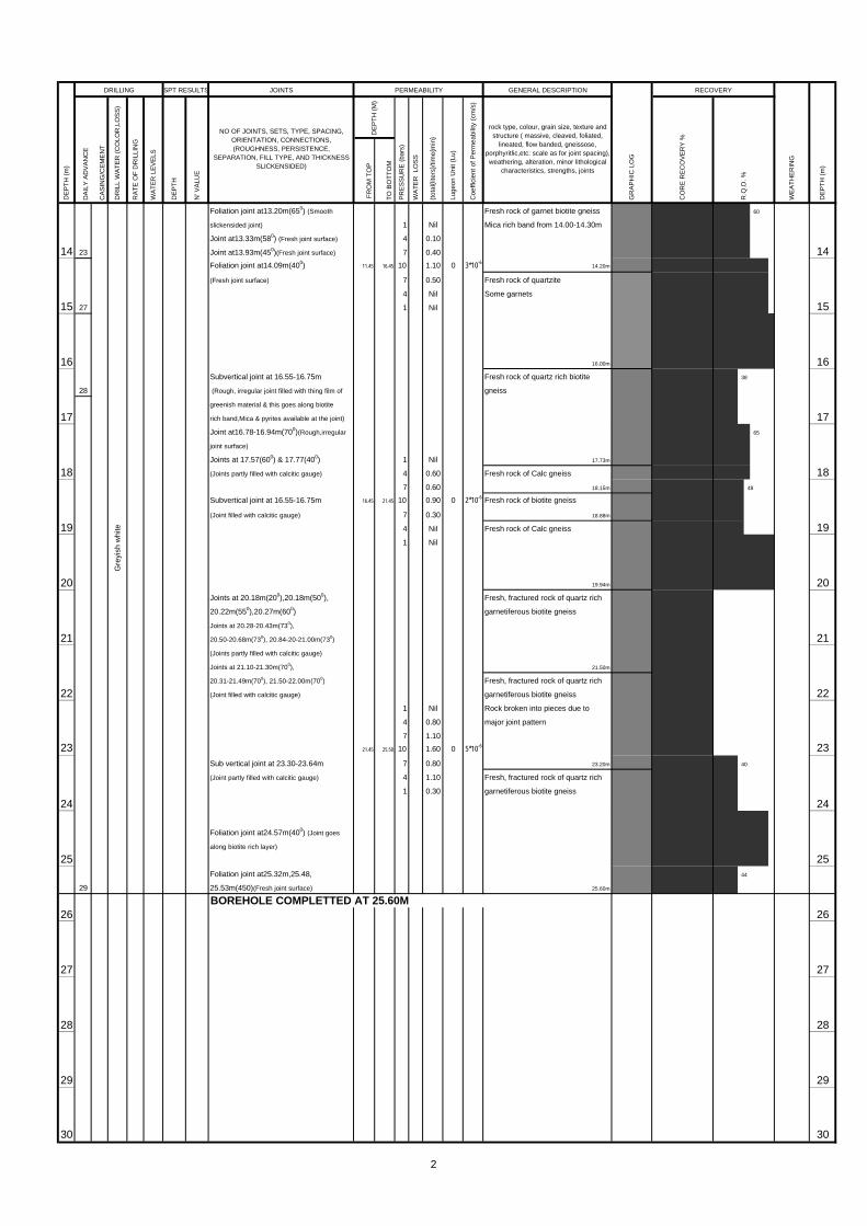
Foliation joint at13.20m(650) (Smooth
slickensided joint) 1 Nil
Joint at13.33m(580) (Fresh joint surface) 4 0.10
14 23 Joint at13.93m(450)(Fresh joint surface) 7 0.40 14Foliation joint at14.09m(400) 11.45 16.45 10 1.10 0 3*10-6
(Fresh joint surface) 7 0.50
4 Nil
15 27 1 Nil 15
16 16Subvertical joint at 16.55-16.75m
28 (Rough, irregular joint filled with thing film of
greenish material & this goes along biotite
17 rich band,Mica & pyrites available at the joint) 17Joint at16.78-16.94m(700)(Rough,irregular
joint surface)
Joints at 17.57(600) & 17.77(400) 1 Nil
18 (Joints partly filled with calcitic gauge) 4 0.60 187 0.60
Subvertical joint at 16.55-16.75m 16.45 21.45 10 0.90 0 2*10-6
(Joint filled with calcitic gauge) 7 0.30
19 4 Nil 191 Nil
20 20Joints at 20.18m(200),20.18m(500),
20.22m(550),20.27m(600)
Joints at 20.28-20.43m(730),
21 20.50-20.68m(730), 20.84-20-21.00m(730) 21(Joints partly filled with calcitic gauge)
Joints at 21.10-21.30m(700),
20.31-21.49m(700), 21.50-22.00m(700)
22 (Joint filled with calcitic gauge) 221 Nil
4 0.80
7 1.10
23 21.45 25.50 10 1.60 0 5*10-6 23Sub vertical joint at 23.30-23.64m 7 0.80
(Joint partly filled with calcitic gauge) 4 1.10
1 0.30
24 24
Foliation joint at24.57m(400) (Joint goes
along biotite rich layer)
25 25Foliation joint at25.32m,25.48,
29 25.53m(450)(Fresh joint surface)
26 26
27 27
28 28
29 29
30 30
25.60m
BOREHOLE COMPLETTED AT 25.60M
23.20m
Fresh, fractured rock of quartz rich
garnetiferous biotite gneiss
major joint pattern
Rock broken into pieces due to
19.94m
Fresh, fractured rock of quartz rich
Fresh, fractured rock of quartz rich
garnetiferous biotite gneiss
21.50m
Fresh rock of Calc gneiss
Fresh rock of Calc gneiss
18.15m
Fresh rock of biotite gneiss
18.88m
17.73m
16.00m
Fresh rock of quartz rich biotite
gneiss
Fresh rock of garnet biotite gneiss
Mica rich band from 14.00-14.30m
14.20m
Fresh rock of quartzite
DE
PT
H (
m)
DRILLING SPT RESULTS PERMEABILITY
WA
TER
LE
VE
LS
DE
PTH
N' V
ALU
E
(tot
al{li
ters
}/tim
e{m
in}
Luge
on U
nit (
Lu)
Coe
ffici
ent o
f Per
mea
bilit
y (c
m/s
)
DE
PT
H (
M)
rock type, colour, grain size, texture andstructure ( massive, cleaved, foliated,
lineated, flow banded, gneissose,porphyritlic,etc: scale as for joint spacing),weathering, alteration, minor lithological
characteristics, strengths, joints
PR
ES
SU
RE
(ba
rs)
WA
TE
R L
OS
S
NO OF JOINTS, SETS, TYPE, SPACING,ORIENTATION, CONNECTIONS,(ROUGHNESS, PERSISTENCE,
SEPARATION, FILL TYPE, AND THICKNESSSLICKENSIDED)
DR
ILL
WA
TE
R (
CO
LOR
,LO
SS
)
RA
TE
OF
DR
ILLI
NG
WE
ATH
ER
ING
DE
PT
H (
m)
CO
RE
RE
CO
VE
RY
%
R.Q
.D. %
40
60
RECOVERY
GR
AP
HIC
LO
G
65
48
GENERAL DESCRIPTION
44
garnetiferous biotite gneiss
Gre
yish
whi
te
38
Some garnets
2

JOINTS D
AIL
Y A
DV
AN
CE
CA
SIN
G/C
EM
EN
T
FR
OM
TO
P
TO
BO
TT
OM
31 31
32 32
33 33
34 34
35 35
36 36
37 37
38 38
39 39
40 40
41 41
42 42
43 43
44 44
45 45
46 46
47 47
DE
PT
H (
m)
DR
ILL
WA
TE
R (
CO
LOR
,LO
SS
)
RA
TE
OF
DR
ILLI
NG
WA
TER
LE
VE
LS
DE
PTH
N' V
ALU
VE
NO OF JOINTS, SETS, TYPE, SPACING,ORIENTATION, CONNECTIONS,
(ROGHNESS, PERSISTANCE, SEPARATION,FILL TYPE, AND THICKNESS SLICKENSIDED)
DE
PT
H (
M)
PR
ES
SU
RE
(ba
rs)
Man
omet
er R
eadi
ng
GENERAL DESCRIPTION
GR
AP
HIC
LO
G
RECOVERY
WE
ATH
ER
ING
rock type, colour, grain size, texture andstructure ( massive, cleaved, foliated,
lineated, flow banded, gneissose,porphyritlic,etc: scale as for joint spacing),weathering, alteration, minor lithological
characteristics, strengths, joints
CO
RE
RE
CO
VE
RY
%
R.Q
.D. %
DE
PT
H (
m)
DRILLING SPT RESULTS PERMEABILITY
WA
TE
R L
OS
S
(tot
al{li
ters
}/tim
e{m
in}
LUG
EO
N o
f K(m
/s)
3

BOREHOLE DATA LEGEND FOR GRAPHIC LOGJOINT SEPARATION Sand
V= very tight Clay
T= tight Fresh to slightly weathered charnockite
MO= moderately open Highly to mod weathered charnockite
O= open Fresh to slightly weathered biotite gneiss
Highly to mod weathered biotite gneiss
Quartzite
SL/CW - Soil & Completely Weathered Calc gneiss
HW - Highly Weathered Boulder
MW - Moderately Weathered TCR RQDSW - Slightly Weathered SL/CW
TCR - Total Core Recovery HW
RQD - Rock Quality Designation MW
GWL - Ground water Level SW
JOINTS
DA
ILY
AD
VA
NC
E
CA
SIN
G/C
EM
EN
T
FR
OM
TO
P
TO
BO
TT
OM
0.00
0.45 6
1 1Joint at 1.40m(300)( Joint surface weathered
25 into rock & rough joint filled with silty clay)
2 22.25 Joint at 2.41m(600) & 2.53m(550)
2.60 (Weathered, rough joint surfaces)
27 / 10 Subvertical joint at 3.00m(Highly weathered,
3 rough joint surface filled with clayey material) 3Joint at 3.35m(550)( Joint surface weathered
into rock & rough joint filled with white gauge)
Joint at 3.75m(350)(Fresh tight joint )
4 4
5 Joint at 5.16m(480) (partly iron stained 5smooth joint surface)
1 0.50
Joint at 5.85m(480) (Fresh joint filled with 4 2.10
6 thing film of brownish material) 7 5.50 64.35 9.08 10 16.00 3 4*10-5
7 5.80
4 1.90
7 26 1 0.20 7Joint at 7.31m(150)(Fresh tight joint )
8 8
9 9
27
10 101 Nil
4 Nil
7 0.02
11 9.08 14.22 10 0.05 0 1*10-7 1129 7 0.03
4 Nil
1 Nil
12 12
13 13
GEOLOGICAL INVESTIGATION FOR THE BROADLANDS HYDROPOWER PROJECT
BOREHOLE LOG FOR ENGINEERING PURPOSES
WEATHERING
WE
ATH
ER
ING
71
RECOVERY
CO
RE
RE
CO
VE
RY
%
DE
PT
H (
m)
DRILLING
DR
ILL
WA
TE
R (
CO
LOR
, LO
SS
)
DE
PT
H (
M)
PR
ES
SU
RE
(ba
rs)
RA
TE
OF
DR
ILLI
NG
R.Q
.D. %
2.36m
Highly weathered rock
1.48m
Fresh rock of charnockitic gneiss
DE
PT
H (
m)
B.H No.: MB 01KEY
STARTED :
WA
TER
LE
VE
LS
NO OF JOINTS, SETS, TYPE, SPACING,ORIENTATION, CONNECTIONS,
(ROGHNESS, PERSISTANCE, SEPARATION,FILL TYPE, AND THICKNESS SLICKENSIDED)
N' V
ALU
VE
DE
PTH
SPT RESULTS PERMEABILITY
DRILLING DATA
VR= very rough
R: rough
LOCATION :- MAIN DAM AXIS,RIGHT BANK
JOINT ROUGHNESS25/10/02
FOREMAN :
LOGGED BY :
MW= moderately wide
C= Closely
VC= very closely
CORE BARREL, BIT :
BMAPM
NQ
WLN
FINAL DEPTH :40.77m
INCLINATION : Vertical
BEARING : -
GR
AP
HIC
LO
G
(tot
al{li
ters
}/tim
e{m
in}
W= widely
GENERAL DESCRIPTION
Rock type, colour, grain size, texture andstructure ( massive, cleaved, foliated,
lineated, flow banded, gneissose,porphyritlic,etc: scale as for joint spacing),weathering, alteration, minor lithological
characteristics, strengths, joints
Luge
on U
nit (
Lu)
Coe
ffici
ent o
f Per
mea
bilit
y (c
m/s
)
JOINT SPACING
VW= very widely> 2m
WA
TE
R L
OS
S
OTHER SYMBOLS
SL=slickensided
X-COORDINATE :164,717.431m
Y-COORDINATE :197,640.971mSR: slightly rough
S= smotth
ELEVATION (BOTTOM) :81.815m
COMPLETED :
MACHING TYPE :
DRILLING METHOD :
ELEVATION (COLLAR) :122.585m
2002/11/4
TONE
ROTARY
Highly to mod . weathered rock of acidic charnockite
Moderately weathered rock of
Highly weathered rock/Rock in pieces
Fresh rock of charnockitic gneiss
biotite schist 2.95m
Quartz rich band from 6.15m-7.30m
Biotite rich band from11.93m to
12.38m
1.00m
clayey silt with few quartz sand
Brown to whitish brown colour
Ligh
t bro
wn
Dar
k br
own
to d
ark
grey
Ligh
t gre
y
LABORATORY & SITEINVESTIGATION UNIT
LABORATORY & SITEINVESTIGATION UNIT
4

JOINTS D
AIL
Y A
DV
AN
CE
CA
SIN
G/C
EM
EN
T
FR
OM
TO
P
TO
BO
TT
OM
14 14
15 15
16 1 Nil 164 Nil
7 0.02
14.22 19.31 10 0.60 0 2*10-7
17 7 0.03 174 Nil
1 Nil
18 18
19 1930
20 20
1 Nil
21 4 Nil 21Joint at 21.46m(600) (Fresh joint filled with 7 0.02
thing film of yellowish material) 19.31 24.17 10 0.50 0 1*10-7
7 0.20
22 31 4 Nil 22Foliation joints at 22.27,22.29 & 1 Nil
22.32m(150) (Rough joint filled with thing
film of greyish material)
23 23
24 241
25 25
26 1 Nil 264 0.01
7 0.03
24.17 29.74 10 0.06 0 1*10-7
27 7 0.02 274 Nil
1 Nil
28 28
29 29
30 30
RECOVERY
WE
ATH
ER
ING
DE
PT
H (
m)
CO
RE
RE
CO
VE
RY
%
R.Q
.D. %
DE
PT
H (
M)
PR
ES
SU
RE
(ba
rs)
WA
TE
R L
OS
S
(tot
al{li
ters
}/tim
e{m
in}
Coe
ffici
ent o
f Per
mea
bilit
y (c
m/s
)
rock type, colour, grain size, texture andstructure ( massive, cleaved, foliated,
lineated, flow banded, gneissose,porphyritlic,etc: scale as for joint spacing),weathering, alteration, minor lithological
characteristics, strengths, joints
GR
AP
HIC
LO
G
GENERAL DESCRIPTION
Luge
on U
nit (
Lu)
DE
PT
H (
m)
DRILLING SPT RESULTS PERMEABILITY
WA
TER
LE
VE
LS
DE
PTH
N' V
ALU
VE
Fresh rock of charnockitic gneiss
Biotite rich band from19.56m to
20.13m
Biotite rich band from 21.95m to
22.14m
RA
TE
OF
DR
ILLI
NG
NO OF JOINTS, SETS, TYPE, SPACING,ORIENTATION, CONNECTIONS,
(ROGHNESS, PERSISTANCE, SEPARATION,FILL TYPE, AND THICKNESS SLICKENSIDED)
Ligh
t bro
wn
DR
ILL
WA
TE
R (
CO
LOR
,LO
SS
)
5

JOINTS
DA
ILY
AD
VA
NC
E
CA
SIN
G/C
EM
EN
T
FR
OM
TO
P
TO
BO
TT
OM
31 312 1 Nil
4 Nil
7 0.04
32 29.74 34.27 10 0.08 0 2*10-7 32
7 0.05
4 Nil
1 Nil
33 33
34 34
35 35
36 1 Nil 364 Nil
7 0.30
34.27 40.77 10 0.09 0 2*10-7
37 7 0.04 374 0.01
3 1 Nil
38 38
39 39
40 40
4
41
42 42
43 43
44 44
45 45
46 46
DE
PT
H (
m)
DRILLING SPT RESULTS PERMEABILITY
(tot
al{li
ters
}/tim
e{m
in}
Luge
on U
nit (
Lu)
Coe
ffici
ent o
f Per
mea
bilit
y (c
m/s
)
GENERAL DESCRIPTION
GR
AP
HIC
LO
G
RECOVERY
WE
ATH
ER
ING
rock type, colour, grain size, texture andstructure ( massive, cleaved, foliated,
lineated, flow banded, gneissose,porphyritlic,etc: scale as for joint spacing),weathering, alteration, minor lithological
characteristics, strengths, joints
CO
RE
RE
CO
VE
RY
%
R.Q
.D. %
DE
PT
H (
m)
DR
ILL
WA
TE
R (
CO
LOR
,LO
SS
)
RA
TE
OF
DR
ILLI
NG
WA
TER
LE
VE
LS
DE
PTH
N' V
ALU
VE
NO OF JOINTS, SETS, TYPE, SPACING,ORIENTATION, CONNECTIONS,
(ROGHNESS, PERSISTANCE, SEPARATION,FILL TYPE, AND THICKNESS SLICKENSIDED)
DE
PT
H (
M)
PR
ES
SU
RE
(ba
rs)
WA
TE
R L
OS
S
Fresh rock of charnockitic gneiss
40.77m
BOREHOLE COMPLETTED AT 40.77M
Ligh
t bro
wn
6

BOREHOLE DATA LEGEND FOR GRAPHIC LOGJOINT SEPARATION Sand
V= very tight Clay
T= tight Fresh to slightly weathered charnockite
MO= moderately open Highly to mod weathered charnockite
O= open Fresh to slightly weathered biotite gneiss
Highly to mod weathered biotite gneiss
Quartzite
SL/CW - Soil & Completely Weathered Calc gneiss
HW - Highly Weathered Boulder
MW - Moderately Weathered TCR RQDSW - Slightly Weathered SL/CW
TCR - Total Core Recovery HW
RQD - Rock Quality Designation MW
GWL - Ground water Level SW
JOINTS
DA
ILY
AD
VA
NC
E
CA
SIN
G/C
EM
EN
T
FR
OM
TO
P
TO
BO
TT
OM
Joint at 0.30-0.46m(700)
Joint at 0.52m(200)
(partly iron stained rough joint surfaces)
1 Joint at 1.22m(400) 1 (Iron stained rough joint surfaces)
Joint at 1.42-1.58m(700)
1.70 Joint at 1.68-1.76m(700)(Iron stained,
2 18 / 10 slightly weathered joint surfaces) 22.20
2.45 1 0.35
2.60 4 2.02
3 12 / 10 7 3.80 33.10 Parallel joints at 3.64m & 3.67m(50) 1.00 5.30 10 6.35 1 2*10-5
13,14 /10 (Iron stained, weathered joint surfaces) 7 4.10
11 4 1.98
4 1 0.42 4
5 5
6 6
1 0.01
7 4 0.02 77 0.03
12 5.30 9.85 10 0.05 0 1*10-7
7 0.04
8 4 0.01 81 Nil
9 913
10 10
1 Nil
4 0.01
11 7 0.03 119.85 14.80 10 0.05 0 1*10-7
7 0.02
4 0.01
12 1 Nil 12
13 13
GEOLOGICAL INVESTIGATION FOR THE BROADLANDS HYDROPOWER PROJECT
BOREHOLE LOG FOR ENGINEERING PURPOSES
S= smotth
DRILLING DATA
VR= very rough
R: rough
KEYJOINT ROUGHNESS
LOCATION :-MAIN DAM AXIS,RIGHT BANK B.H No.: MB 02
37
SPT RESULTS PERMEABILITY
BEARING : -
Luge
on U
nit (
Lu)
Coe
ffici
ent o
f Per
mea
bilit
y (c
m/s
)
RECOVERY
CO
RE
RE
CO
VE
RY
%
57
75
SR: slightly rough
WEATHERING
WE
ATH
ER
ING
RA
TE
OF
DR
ILLI
NG
DE
PT
H (
M)
PR
ES
SU
RE
(ba
rs)
DE
PTH
NQ
WLN
ROTARY
CORE BARREL, BIT :
BMAPM
WA
TER
LE
VE
LS
DE
PT
H (
m)
DE
PT
H (
m)
DRILLING
DR
ILL
WA
TE
R (
CO
LOR
, LO
SS
)
LOGGED BY :
GENERAL DESCRIPTION
Rock type, colour, grain size, texture andstructure ( massive, cleaved, foliated,
lineated, flow banded, gneissose,porphyritlic,etc: scale as for joint spacing),weathering, alteration, minor lithological
characteristics, strengths, joints
STARTED :
COMPLETED :
MACHING TYPE :
2002/10/11
R.Q
.D. %
NO OF JOINTS, SETS, TYPE, SPACING,ORIENTATION, CONNECTIONS,
(ROGHNESS, PERSISTANCE, SEPARATION,FILL TYPE, AND THICKNESS SLICKENSIDED)
N' V
ALU
VE
GR
AP
HIC
LO
G
(tot
al{li
ters
}/tim
e{m
in}
84
75
OTHER SYMBOLS
VW= very widely> 2m
W= widely
JOINT SPACING
SL=slickensided
ELEVATI ON (BOTTOM) :69.300m
FINAL DEPTH :40.13m
INCLINATION : VerticalC= Closely
VC= very closely
MW= moderately wide
DRILLING METHOD :
Fresh rock of charnockitic gneiss
WA
TE
R L
OS
S
Whi
tish
grey
FOREMAN :
Biotite rich band at 10.82m-10.92m
X-COORDINATE :164,701.313m
Y-COORDINATE :197,626.567m
ELEVATION (COLLAR) :109.430m
18/10/02
TONE
LABORATORY & SITEINVESTIGATION UNIT
LABORATORY & SITEINVESTIGATION UNIT
7

JOINTS D
AIL
Y A
DV
AN
CE
CA
SIN
G/C
EM
EN
T
FR
OM
TO
P
TO
BO
TT
OM
14 14
15 15
14
16 16Joint at 16.37m(450) 1 Nil
(Smooth mica rich joint surface) 4 0.01
7 0.02
17 14.80 19.54 10 0.04 0 1*10-7 177 0.03
4 0.01
1 Nil
18 18
19 19
20 20
Foliation joints at 20.82 &20.86m (300) 1 Nil
21 (Fresh, tight joints) 4 Nil 217 0.01
19.54 24.05 10 0.03 0 9*10-8
7 0.02
22 4 Nil 2215 1 Nil
23 23
24 24
Foliation joint at 24.72m (300)
25 (Fresh, tight joint) 25
1 Nil
4 0.01
26 7 0.02 2624.05 29.93 10 0.04 0 9*10-8
7 0.03
4 Nil
27 1 Nil 27
28 2816
29 29
30 30
RECOVERY
WE
ATH
ER
ING
GR
AP
HIC
LO
G
GENERAL DESCRIPTION
DE
PT
H (
m)
CO
RE
RE
CO
VE
RY
%
R.Q
.D. %
PR
ES
SU
RE
(ba
rs)
WA
TE
R L
OS
S
(tot
al{li
ters
}/tim
e{m
in}
Coe
ffici
ent o
f Per
mea
bilit
y (c
m/s
)
rock type, colour, grain size, texture andstructure ( massive, cleaved, foliated,
lineated, flow banded, gneissose,porphyritlic,etc: scale as for joint spacing),weathering, alteration, minor lithological
characteristics, strengths, joints
DE
PT
H (
m)
DRILLING SPT RESULTS PERMEABILITY
WA
TER
LE
VE
LS
DE
PTH
N' V
ALU
VE
NO OF JOINTS, SETS, TYPE, SPACING,ORIENTATION, CONNECTIONS,
(ROGHNESS, PERSISTANCE, SEPARATION,FILL TYPE, AND THICKNESS SLICKENSIDED)
DR
ILL
WA
TE
R (
CO
LOR
,LO
SS
)
RA
TE
OF
DR
ILLI
NG
Fresh rock of charnockitic gneiss
Luge
on U
nit (
Lu)
DE
PT
H (
M)
Biotite rich band at 16.35m-16.55m
Biotite rich band at 17.35m-17.46m
Biotite rich band at 17.89m-18.05m
23.22m
Fresh rock of pegmatite
23.66m
Fresh rock of granulitic biotite
gneiss
Whi
tish
grey
8

JOINTS
DA
ILY
AD
VA
NC
E
CA
SIN
G/C
EM
EN
T
FR
OM
TO
P
TO
BO
TT
OM
31 31
1 Nil
32 4 0.01 327 0.02
29.93 35.25 10 0.04 0 1*10-7
7 0.02
33 4 Nil 331 Nil
34 34
35 35
36 36
17 1 Nil
37 4 0.01 377 0.02
35.25 40.13 10 0.04 0 1*10-7
7 0.02
38 4 0.01 381 Nil
39 39
40 18 40
41 41
42 42
43 43
44 44
45 45
46 46
DE
PT
H (
m)
DRILLING SPT RESULTS PERMEABILITY
(tot
al{li
ters
}/tim
e{m
in}
Luge
on U
nit (
Lu)
Coe
ffici
ent o
f Per
mea
bilit
y (c
m/s
)
GENERAL DESCRIPTION
GR
AP
HIC
LO
G
RECOVERY
WE
ATH
ER
ING
rock type, colour, grain size, texture andstructure ( massive, cleaved, foliated,
lineated, flow banded, gneissose,porphyritlic,etc: scale as for joint spacing),weathering, alteration, minor lithological
characteristics, strengths, joints
CO
RE
RE
CO
VE
RY
%
R.Q
.D. %
DE
PT
H (
m)
DR
ILL
WA
TE
R (
CO
LOR
,LO
SS
)
RA
TE
OF
DR
ILLI
NG
WA
TER
LE
VE
LS
DE
PTH
N' V
ALU
VE
NO OF JOINTS, SETS, TYPE, SPACING,ORIENTATION, CONNECTIONS,
(ROGHNESS, PERSISTANCE, SEPARATION,FILL TYPE, AND THICKNESS SLICKENSIDED)
DE
PT
H (
M)
PR
ES
SU
RE
(ba
rs)
WA
TE
R L
OS
S
Fresh rock of granulitic biotite
gneiss
BOREHOLE COMPLETTED AT 40.13M
Whi
tish
grey
40.13m
9

BOREHOLE DATA LEGEND FOR GRAPHIC LOGJOINT SEPARATION Sand
V= very tight Clay
T= tight Fresh to slightly weathered charnockite
MO= moderately open Highly to mod weathered charnockite
O= open Fresh to slightly weathered biotite gneiss
Highly to mod weathered biotite gneiss
Quartzite
SL/CW - Soil & Completely Weathered Calc gneiss
HW - Highly Weathered Boulder
MW - Moderately Weathered TCR RQDSW - Slightly Weathered SL/CW
TCR - Total Core Recovery HW
RQD - Rock Quality Designation MW
GWL - Ground water Level SW
JOINTS
DA
ILY
AD
VA
NC
E
CA
SIN
G/C
EM
EN
T
FR
OM
TO
P
TO
BO
TT
OM
0.00
From 17th
1 11.23
7 /12
1 Nil
2 4 Nil 22.38 7 0.03
6 2.60 Joint at 3.64m (300) (Fresh, tight joint) 0.65 5.00 10 0.05 0 1*10-7
10 /12 7 0.02
3 4 Nil 31 Nil
4 4
5 7 Joint at 5.03m (600) 5(Partly chloritized, tight joint)
6 6
1 Nil
7 4 Nil 77 0.03
5.00 10.00 10 0.05 0 1*10-7
7 0.03
8 9 4 0.01 81 Nil
9 9
10 10
1 Nil
11 10 4 Nil 117 0.03
10.00 15.00 10 0.05 0 1*10-7
7 0.04
12 4 0.01 121 Nil
13 13
GEOLOGICAL INVESTIGATION FOR THE BROADLANDS HYDROPOWER PROJECT
BOREHOLE LOG FOR ENGINEERING PURPOSESG
rey
DE
PT
H (
m)
DE
PT
H (
m)
DRILLING
LOCATION :-MAIN DAM AXIS,LEFT BANK B.H No.: MB 03
WEATHERING
WE
ATH
ER
ING
SPT RESULTS PERMEABILITY
RA
TE
OF
DR
ILLI
NG
DR
ILL
WA
TE
R (
CO
LOR
, LO
SS
)
DE
PT
H (
M)
PR
ES
SU
RE
(ba
rs)
WA
TER
LE
VE
LS
NO OF JOINTS, SETS, TYPE, SPACING,ORIENTATION, CONNECTIONS,
(ROGHNESS, PERSISTANCE, SEPARATION,FILL TYPE, AND THICKNESS SLICKENSIDED)
N' V
ALU
VE
DE
PTH
DRILLING DATA
VR= very rough
R: rough
VW= very widely> 2mELEVATION (BOTTOM) :57.225m
STARTED :
COMPLETED :
MACHING TYPE :
DRILLING METHOD :
ELEVATION (COLLAR) :107.225m
SR: slightly rough
S= smotth
W= widely
GENERAL DESCRIPTION
Rock type, colour, grain size, texture andstructure ( massive, cleaved, foliated,
lineated, flow banded, gneissose,porphyritlic,etc: scale as for joint spacing),weathering, alteration, minor lithological
characteristics, strengths, joints
Luge
on U
nit (
Lu)
Coe
ffici
ent o
f Per
mea
bilit
y (c
m/s
)
FOREMAN :
LOGGED BY :
MW= moderately wide
C= Closely
VC= very closely
CORE BARREL, BIT :
BMAPM
FINAL DEPTH :50.00m
INCLINATION : Inclined (500)
X-COORDINATE :164,673.670m
Y-COORDINATE :197,602.979m
WA
TE
R L
OS
S
RECOVERY
CO
RE
RE
CO
VE
RY
%
R.Q
.D. %
JOINT SPACING
GR
AP
HIC
LO
G
(tot
al{li
ters
}/tim
e{m
in}
KEY
OTHER SYMBOLS
JOINT ROUGHNESS
SL=slickensided
NX
MRAMHP
Fresh rock of charnockitic gneiss
BEARING : -
Biotite rich band at 7.36m-7.56m
2002/12/6
21/12/02
TONE
ROTARY
LABORATORY & SITEINVESTIGATION UNIT
LABORATORY & SITEINVESTIGATION UNIT
10
JOINTS D
AIL
Y A
DV
AN
CE
CA
SIN
G/C
EM
EN
T
FR
OM
TO
P
TO
BO
TT
OM
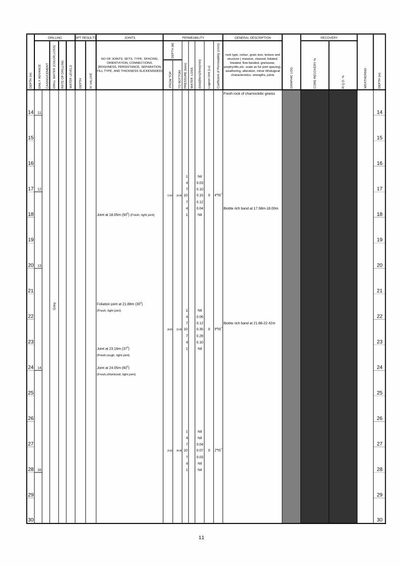
14 11 14
15 15
16 16
1 Nil
4 0.03
17 12 7 0.10 1715.00 20.00 10 0.15 0 4*10-7
7 0.12
4 0.04
18 Joint at 18.05m (500) (Fresh, tight joint) 1 Nil 18
19 19
20 13 20
21 21
Foliation joint at 21.88m (300)
(Fresh, tight joint) 1 Nil
22 4 0.06 227 0.12
20.00 25.00 10 0.35 0 9*10-7
7 0.28
23 4 0.10 23Joint at 23.16m (370) 1 Nil
(Fresh,rough, tight joint)
24 14 Joint at 24.05m (600) 24(Fresh,chloritized, tight joint)
25 25
26 26
1 Nil
4 Nil
27 7 0.04 2725.00 30.00 10 0.07 0 2*10-7
7 0.03
4 Nil
28 16 1 Nil 28
29 29
30 30
Gre
y
WE
ATH
ER
ING
DE
PT
H (
m)
CO
RE
RE
CO
VE
RY
%
R.Q
.D. %
RECOVERY
rock type, colour, grain size, texture andstructure ( massive, cleaved, foliated,
lineated, flow banded, gneissose,porphyritlic,etc: scale as for joint spacing),weathering, alteration, minor lithological
characteristics, strengths, joints
GR
AP
HIC
LO
G
GENERAL DESCRIPTION
DE
PT
H (
M)
PR
ES
SU
RE
(ba
rs)
WA
TE
R L
OS
S
(tot
al{li
ters
}/tim
e{m
in}
Luge
on U
nit (
Lu)
Coe
ffici
ent o
f Per
mea
bilit
y (c
m/s
)
DE
PT
H (
m)
DRILLING SPT RESULTS PERMEABILITY
WA
TER
LE
VE
LS
DE
PTH
N' V
ALU
VE
NO OF JOINTS, SETS, TYPE, SPACING,ORIENTATION, CONNECTIONS,
(ROGHNESS, PERSISTANCE, SEPARATION,FILL TYPE, AND THICKNESS SLICKENSIDED)
DR
ILL
WA
TE
R (
CO
LOR
,LO
SS
)
RA
TE
OF
DR
ILLI
NG
Fresh rock of charnockitic gneiss
Biotite rich band at 17.58m-18.00m
Biotite rich band at 21.88-22.42m
11

JOINTS
DA
ILY
AD
VA
NC
E
CA
SIN
G/C
EM
EN
T
FR
OM
TO
P
TO
BO
TT
OM
Joint at 30.57m (450)
(Fresh,chloritized, tight joint)
31 31
1 Nil
32 17 4 Nil 32Foliation joint at 32.28m (550) 7 0.03
(Fresh, tight joint) Joint goes along biotite 30.00 35.00 10 0.05 0 1*10-7
rich layer 7 0.03
33 4 0.01 331 Nil
34 34
35 35
36 18 36
1 Nil
4 Nil
37 7 0.02 3735.00 40.00 10 0.04 0 1*10-7
7 0.03
4 Nil
38 1 Nil 38
39 39
40 19 40
41 41
1 Nil
4 Nil
42 7 0.02 4240.00 45.00 10 0.04 0 1*10-7
7 0.02
4 Nil
43 1 Nil 43
44 44
45 20 45
46 46
Joint at 46.46m (600)
Joint at 46.55m (600)
47 (Fresh,chloritized, tight joints) 47
83
Gre
y
DE
PT
H (
m)
DRILLING SPT RESULTS PERMEABILITY
(tot
al{li
ters
}/tim
e{m
in}
Luge
on U
nit (
Lu)
Coe
ffici
ent o
f Per
mea
bilit
y (c
m/s
)
GENERAL DESCRIPTION
GR
AP
HIC
LO
G
RECOVERY
WE
ATH
ER
ING
rock type, colour, grain size, texture andstructure ( massive, cleaved, foliated,
lineated, flow banded, gneissose,porphyritlic,etc: scale as for joint spacing),weathering, alteration, minor lithological
characteristics, strengths, joints
CO
RE
RE
CO
VE
RY
%
R.Q
.D. %
DE
PT
H (
m)
DR
ILL
WA
TE
R (
CO
LOR
,LO
SS
)
RA
TE
OF
DR
ILLI
NG
WA
TER
LE
VE
LS
DE
PTH
N' V
ALU
VE
NO OF JOINTS, SETS, TYPE, SPACING,ORIENTATION, CONNECTIONS,
(ROGHNESS, PERSISTANCE, SEPARATION,FILL TYPE, AND THICKNESS SLICKENSIDED)
DE
PT
H (
M)
PR
ES
SU
RE
(ba
rs)
WA
TE
R L
OS
S
Fresh rock of charnockitic gneiss
Biotite rich band at 32.28-32.50m
40.40m
Fresh rock of garnet biotite gneiss
12

JOINTS D
AIL
Y A
DV
AN
CE
CA
SIN
G/C
EM
EN
T
FR
OM
TO
P
TO
BO
TT
OM
1 Nil
4 0.02
48 7 0.06 4845.00 50.00 10 0.14 0 4*10-7
7 0.07
4 0.02
49 1 Nil 49
50 21 50
51 51
52 52
53 53
54 54
55 55
56 56
57 57
58 58
59 59
60 60
61 61
62 62
63 63
64 64
BOREHOLE COMPLETTED AT 50.00M
Gre
y
50.00m
Fresh rock of garnet biotite gneiss
DE
PT
H (
m)
DR
ILL
WA
TE
R (
CO
LOR
,LO
SS
)
RA
TE
OF
DR
ILLI
NG
WA
TER
LE
VE
LS
DE
PTH
N' V
ALU
VE
NO OF JOINTS, SETS, TYPE, SPACING,ORIENTATION, CONNECTIONS,
(ROGHNESS, PERSISTANCE, SEPARATION,FILL TYPE, AND THICKNESS SLICKENSIDED)
DE
PT
H (
M)
PR
ES
SU
RE
(ba
rs)
Man
omet
er R
eadi
ng
GENERAL DESCRIPTION
GR
AP
HIC
LO
G
RECOVERY
WE
ATH
ER
ING
rock type, colour, grain size, texture andstructure ( massive, cleaved, foliated,
lineated, flow banded, gneissose,porphyritlic,etc: scale as for joint spacing),weathering, alteration, minor lithological
characteristics, strengths, joints
CO
RE
RE
CO
VE
RY
%
R.Q
.D. %
DE
PT
H (
m)
DRILLING SPT RESULTS PERMEABILITY
WA
TE
R L
OS
S
(tot
al{li
ters
}/tim
e{m
in}
LUG
EO
N o
f K(m
/s)
13

BOREHOLE DATA LEGEND FOR GRAPHIC LOGJOINT SEPARATION Sand
V= very tight Clay
T= tight Fresh to slightly weathered charnockite
MO= moderately open Highly to mod weathered charnockite
O= open Fresh to slightly weathered biotite gneiss
Highly to mod weathered biotite gneiss
Quartzite
SL/CW - Soil & Completely Weathered Calc gneiss
HW - Highly Weathered Boulder
MW - Moderately Weathered TCR RQDSW - Slightly Weathered SL/CW
TCR - Total Core Recovery HW
RQD - Rock Quality Designation MW
GWL - Ground water Level SW
JOINTS
DA
ILY
AD
VA
NC
E
CA
SIN
G/C
EM
EN
T
FR
OM
TO
P
TO
BO
TT
OM
0.00
0.45 8
1 1
1.68
28 /12 1.55
2 1.95 2.00 17 2 29 /12
3 3.85 3 27 /12
4 4Joint at 4.48m(650)(Weathered ,rough,
filled with clayey silt)
100% water loss at 4.48m
5 26 5
6 6
7 1 Nil 74 0.02
7 0.05
5.40 10.00 10 0.08 0 2*10-7
8 7 0.06 84 0.03
1 Nil
9 99.39
31 / 12
10 1010.19
1 / 1
11 1 Nil 114 0.04
7 0.08
5.00 15.00 10 0.13 0 3*10-7
12 27 7 0.09 124 0.40
1 Nil
13 13
GEOLOGICAL INVESTIGATION FOR THE BROADLANDS HYDROPOWER PROJECT
BOREHOLE LOG FOR ENGINEERING PURPOSES
26/12/02
2003/1/1
X-COORDINATE :164,658.747m
Y-COORDINATE :197,585.707m
DRILLING DATA
STARTED :
COMPLETED :
Ligh
t bro
wn
Gre
y
11.10m
Fresh rock of charnockitic gneiss
9.28m
Fresh rock of pegmatite
4.88m
Fresh rock of charnockitic gneiss
NX
MRAMHP
Highly to moderately weathered
1.00m
Yellowish brown soft sandy clay
0.45m
Yellowish brown soft silty clay(Top soil)
BEARING : -
W= widely
RA
TE
OF
DR
ILLI
NG
GR
AP
HIC
LO
G
(tot
al{li
ters
}/tim
e{m
in}
KEY
OTHER SYMBOLS
JOINT ROUGHNESS
SL=slickensided
WA
TE
R L
OS
S
VR= very rough
R: rough
VW= very widely> 2m
FOREMAN :
LOGGED BY :
MW= moderately wide
C= Closely
VC= very closely
CORE BARREL, BIT :
BMAPM
FINAL DEPTH :40.00m
INCLINATION : Vertical
MACHING TYPE :
DRILLING METHOD :
SR: slightly rough
S= smotth
JOINT SPACING
ELEVATION (COLLAR) :116.814m
ELEVATION (BOTTOM) :76.814m
TONE
ROTARY
rock of garnet biotite gneiss
DE
PT
H (
m)
DRILLING
LOCATION :-MAIN DAM AXIS,LEFT BANK B.H No.: MB 04
GENERAL DESCRIPTION
Rock type, colour, grain size, texture andstructure ( massive, cleaved, foliated,
lineated, flow banded, gneissose,porphyritlic,etc: scale as for joint spacing),weathering, alteration, minor lithological
characteristics, strengths, joints
WA
TER
LE
VE
LS
NO OF JOINTS, SETS, TYPE, SPACING,ORIENTATION, CONNECTIONS,
(ROGHNESS, PERSISTANCE, SEPARATION,FILL TYPE, AND THICKNESS SLICKENSIDED)
N' V
ALU
VE
DE
PTH
DR
ILL
WA
TE
R (
CO
LOR
, LO
SS
)
DE
PT
H (
M)
PR
ES
SU
RE
(ba
rs)
DE
PT
H (
m)
Luge
on U
nit (
Lu)
Coe
ffici
ent o
f Per
mea
bilit
y (c
m/s
)
SPT RESULTS PERMEABILITY RECOVERY
CO
RE
RE
CO
VE
RY
%
WEATHERING
WE
ATH
ER
ING
85
R.Q
.D. %
Yellowish brown,soft, silty clay
Boulder of weathered rock
(Boulder has crushed into pieces)
2.00m
LABORATORY & SITEINVESTIGATION UNIT
LABORATORY & SITEINVESTIGATION UNIT
LABORATORY & SITEINVESTIGATION UNIT
14

JOINTS D
AIL
Y A
DV
AN
CE
CA
SIN
G/C
EM
EN
T
FR
OM
TO
P
TO
BO
TT
OM
14 14Joint at 14.20m (600) (Fresh, tight joint)
15 Joint at15.04m(100) 15(Partly iron stained rough joint surface)
16 16Foliation joints at 16.50 & 16.53m (600)
(Fresh, tight joints)
17 1 Nil 1717.23 4 0.03
30 / 12 Joint at 17.63m (500) (Fresh, tight joint) 7 0.06
28 15.00 20.00 10 0.10 0 3*10-7
18 Joint at 17.92m (450) (Fresh, tight joint) 7 0.06 18Foliation joints at 18.06,18.15,18.23, 4 0.04
18.48 &18.93m (600) 1 Nil
(Fresh, tight joints)
19 19Foliation joint at 19.25m (500)
(Fresh, tight joint)
20 20
21 21Rock in pieces due to joints
(Chloritized, tight joint-may be foliation joints)
1 0.02
22 Joint at 22.33-22.52m (750)(Chloritized, tight joint) 4 0.16 22Foliation joint at 22.68-22.98m (750) 7 0.28
(Chloritized,slickensided, tight joint) 20.00 25.00 10 0.45 0 1*10-6
Joint at 22.80m (300) (Chloritized, tight joint) 7 0.30
23 Joints at 22.90 & 22.96m (500) 4 0.18 23(Chloritized,slickensided, tight joint) 1 0.03
Vertical joint at 23.00-23.30m (500)
(Fresh, tight joint)
24 24
25 29 25
26 26
1 Nil
4 Nil
27 7 0.04 2725.00 30.00 10 0.08 0 3*10-7
7 0.05
4 0.02
28 1 Nil 28
29 29
30 30
Gre
yD
RIL
L W
AT
ER
(C
OLO
R,L
OS
S)
Rock in pieces(From 21.00-21.56m)
Maximum-5cm
Biotite rich layers appeared & rock
RA
TE
OF
DR
ILLI
NG
Fresh rock of charnockitic gneiss
DE
PT
H (
m)
DRILLING SPT RESULTS PERMEABILITY
WA
TER
LE
VE
LS
DE
PTH
N' V
ALU
VE
NO OF JOINTS, SETS, TYPE, SPACING,ORIENTATION, CONNECTIONS,
(ROGHNESS, PERSISTANCE, SEPARATION,FILL TYPE, AND THICKNESS SLICKENSIDED)
GR
AP
HIC
LO
G
GENERAL DESCRIPTION
DE
PT
H (
M)
PR
ES
SU
RE
(ba
rs)
WA
TE
R L
OS
S
(tot
al{li
ters
}/tim
e{m
in}
Luge
on U
nit (
Lu)
Coe
ffici
ent o
f Per
mea
bilit
y (c
m/s
)
rock type, colour, grain size, texture andstructure ( massive, cleaved, foliated,
lineated, flow banded, gneissose,porphyritlic,etc: scale as for joint spacing),weathering, alteration, minor lithological
characteristics, strengths, joints
RECOVERY
WE
ATH
ER
ING
DE
PT
H (
m)
CO
RE
RE
CO
VE
RY
%
R.Q
.D. %
63
46
30
70
is jointed along this layers
15

JOINTS
DA
ILY
AD
VA
NC
E
CA
SIN
G/C
EM
EN
T
FR
OM
TO
P
TO
BO
TT
OM
31 31
1 Nil
4 0.03
32 7 0.18 3230.00 35.00 10 0.25 0 6*10-7
7 0.19
4 0.04
33 1 Nil 33
34 30 34
35 35
36 36
Joints at 36.55 & 36.88m(450)
(Joint filled with thing film of calcitic gauge) 1 Nil
37 4 0.03 377 0.18
35.00 40.00 10 0.25 0 6*10-7
Vertical joint at 37.65-37.92m 7 0.19
38 (Joint filled with thing film of calcitic gauge) 4 0.04 381 Nil
39 39
40 31 40
41 41
42 42
43 43
44 44
45 45
46 46
40.00m
BOREHOLE COMPLETTED AT 40.00M
39.00m
Fresh rock of charnockitic gneiss
Gre
y Fresh rock of calc. gneiss
34.80m
Fresh rock of charnockitic gneiss
DE
PT
H (
m)
DR
ILL
WA
TE
R (
CO
LOR
,LO
SS
)
RA
TE
OF
DR
ILLI
NG
WA
TER
LE
VE
LS
DE
PTH
N' V
ALU
VE
NO OF JOINTS, SETS, TYPE, SPACING,ORIENTATION, CONNECTIONS,
(ROGHNESS, PERSISTANCE, SEPARATION,FILL TYPE, AND THICKNESS SLICKENSIDED)
DE
PT
H (
M)
PR
ES
SU
RE
(ba
rs)
WA
TE
R L
OS
S
GENERAL DESCRIPTION
GR
AP
HIC
LO
G
RECOVERY
WE
ATH
ER
ING
rock type, colour, grain size, texture andstructure ( massive, cleaved, foliated,
lineated, flow banded, gneissose,porphyritlic,etc: scale as for joint spacing),weathering, alteration, minor lithological
characteristics, strengths, joints
CO
RE
RE
CO
VE
RY
%
R.Q
.D. %
DE
PT
H (
m)
DRILLING SPT RESULTS PERMEABILITY
(tot
al{li
ters
}/tim
e{m
in}
Luge
on U
nit (
Lu)
Coe
ffici
ent o
f Per
mea
bilit
y (c
m/s
)
85
73
Mica rich band at 35.59-35.73m &
core is partly washed out at this band
16
BOREHOLE DATA LEGEND FOR GRAPHIC LOGJOINT SEPARATION Sand
V= very tight Clay
T= tight Fresh to slightly weathered charnockite
MO= moderately open Highly to mod weathered charnockite
O= open Fresh to slightly weathered biotite gneiss
Highly to mod weathered biotite gneiss
Quartzite
SL/CW - Soil & Completely Weathered Calc gneiss
HW - Highly Weathered Boulder
MW - Moderately Weathered TCR RQDSW - Slightly Weathered SL/CW
TCR - Total Core Recovery HW
RQD - Rock Quality Designation MW
GWL - Ground water Level SW
JOINTS
DA
ILY
AD
VA
NC
E
CA
SIN
G/C
EM
EN
T
FR
OM
TO
P
TO
BO
TT
OM
0.00
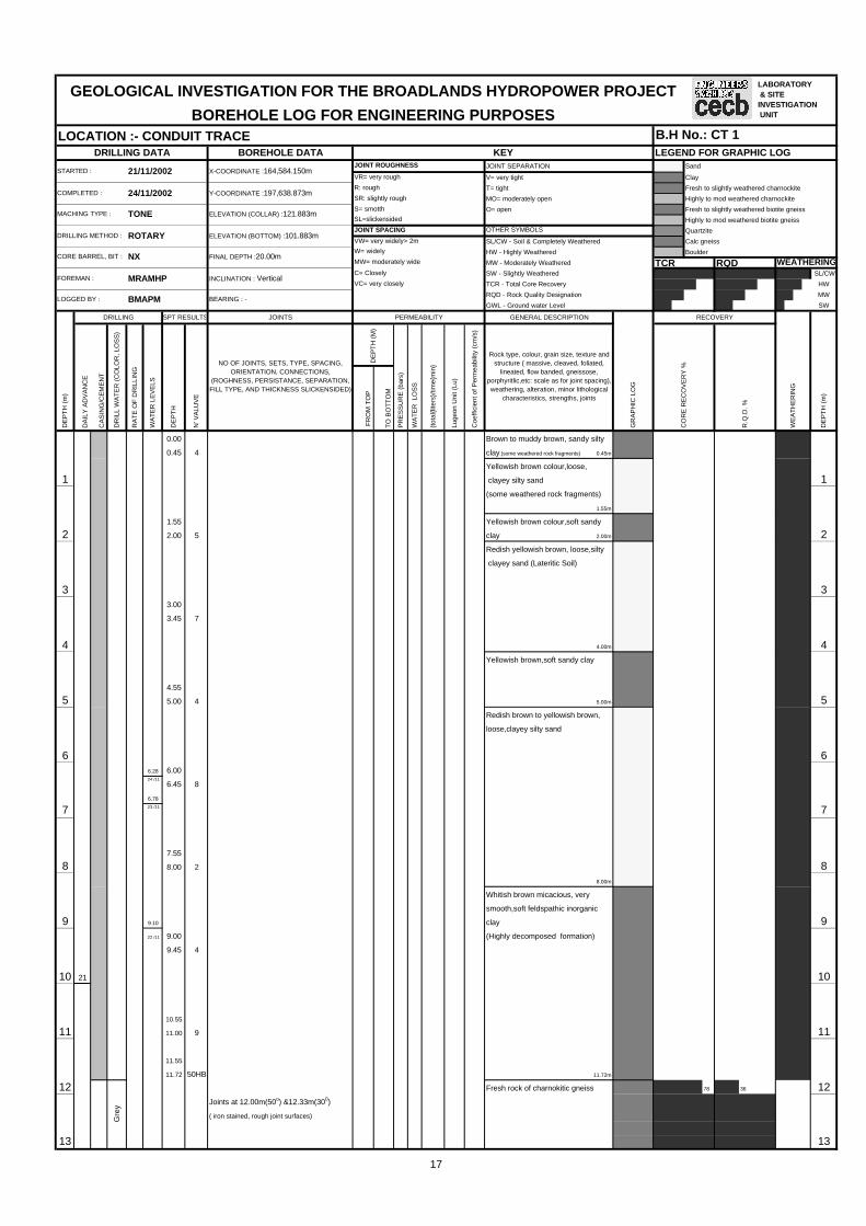
0.45 4 clay.(some weathered rock fragments) 0.45m
Yellowish brown colour,loose,
1 clayey silty sand 1(some weathered rock fragments)
1.55m
1.55 Yellowish brown colour,soft sandy
2 2.00 5 clay 2.00m 2Redish yellowish brown, loose,silty
clayey sand (Lateritic Soil)
3 33.00
3.45 7
4 4.00m 4Yellowish brown,soft sandy clay
4.55
5 5.00 4 5.00m 5Redish brown to yellowish brown,
loose,clayey silty sand
6 66.28 6.00
24 /116.45 8
6.78
7 23 /11 7
7.55
8 8.00 2 88.00m
Whitish brown micacious, very
smooth,soft feldspathic inorganic
9 9.10 clay 9 22 /11 9.00 (Highly decomposed formation)
9.45 4
10 21 10
10.55
11 11.00 9 11
11.55
11.72 50HB 11.72m
12 Fresh rock of charnokitic gneiss 12Joints at 12.00m(50o) &12.33m(300)
( iron stained, rough joint surfaces)
13 13
78
FOREMAN :
Gre
y
LOGGED BY :
DR
ILL
WA
TE
R (
CO
LOR
, LO
SS
)
MACHING TYPE :
DRILLING METHOD :
CORE BARREL, BIT : NX
TONE
ELEVATION (BOTTOM) :101.883m
FINAL DEPTH :20.00m
INCLINATION : Vertical
ROTARYOTHER SYMBOLS
JOINT ROUGHNESS
SL=slickensided
JOINT SPACING
SR: slightly rough
S= smotth
MW= moderately wide
C= Closely
VC= very closely
W= widely
ELEVATION (COLLAR) :121.883m
24/11/2002
VW= very widely> 2m
DRILLING DATA
VR= very rough
R: rough
KEY
X-COORDINATE :164,584.150m
Y-COORDINATE :197,638.873m
21/11/2002STARTED :
COMPLETED :
DE
PTH
BMAPM
WA
TER
LE
VE
LS
N' V
ALU
VE
DRILLING
RA
TE
OF
DR
ILLI
NG
DE
PT
H (
m)
Brown to muddy brown, sandy silty
36
RECOVERY
CO
RE
RE
CO
VE
RY
%
DE
PT
H (
M)
PR
ES
SU
RE
(ba
rs)
R.Q
.D. %
GR
AP
HIC
LO
G
(tot
al{li
ters
}/tim
e{m
in}
GENERAL DESCRIPTION
Coe
ffici
ent o
f Per
mea
bilit
y (c
m/s
)
WA
TE
R L
OS
S
WEATHERING
WE
ATH
ER
ING
SPT RESULTS PERMEABILITY
DE
PT
H (
m)
MRAMHP
BEARING : -
NO OF JOINTS, SETS, TYPE, SPACING,ORIENTATION, CONNECTIONS,
(ROGHNESS, PERSISTANCE, SEPARATION,FILL TYPE, AND THICKNESS SLICKENSIDED)
Rock type, colour, grain size, texture andstructure ( massive, cleaved, foliated,
lineated, flow banded, gneissose,porphyritlic,etc: scale as for joint spacing),weathering, alteration, minor lithological
characteristics, strengths, joints
Luge
on U
nit (
Lu)
GEOLOGICAL INVESTIGATION FOR THE BROADLANDS HYDROPOWER PROJECT
BOREHOLE LOG FOR ENGINEERING PURPOSESLOCATION :- CONDUIT TRACE B.H No.: CT 1
LABORATORY & SITEINVESTIGATION UNIT
17

JOINTS D
AIL
Y A
DV
AN
CE
CA
SIN
G/C
EM
EN
T
FR
OM
TO
P
TO
BO
TT
OM
1 Nil
4 Nil
7 0.05
14 12.50 15.35 10 0.07 0 3*10-7 147 0.04
4 Nil
1 Nil
15 1522
Joint at 15.72m(40o)
16 ( Iron stained rough surface) 16
Joint at 16.46m(32o) (tight joint)
17 1 Nil 174 0.12
7 0.20
15.35 20.00 10 0.28 0 7*10-7
18 7 0.23 184 0.13
1 Nil
19 19
Joint at 19.85m(60o) (fresh tight joint)
20 2023
BOREHOLE COMPLETED AT 20.00M
21 21
22 22
23 23
24 24
25 25
26 26
27 27
28 28
29 29
30 30
Gre
y
Fresh rock of charnokitic gneiss
Weathered portion from 17.67m to
20.00m
18.51m
Highly to moderately weathered rock
of charnokitic gneiss 71
81 81
17.80m
15.35m
(High content of quartz)
19.17m
Fresh rock of charnokitic gneiss
Fresh rock of charnokitic gneiss
DE
PT
H (
m)
DRILLING SPT RESULTS
DR
ILL
WA
TE
R (
CO
LOR
,LO
SS
)
RA
TE
OF
DR
ILLI
NG
WA
TER
LE
VE
LS
WA
TE
R L
OS
S
(tot
al{li
ters
}/tim
e{m
in}
Coe
ffici
ent o
f Per
mea
bilit
y (c
m/s
)
Luge
on U
nit (
Lu)
NO OF JOINTS, SETS, TYPE, SPACING,ORIENTATION, CONNECTIONS,
(ROGHNESS, PERSISTANCE, SEPARATION,FILL TYPE, AND THICKNESS SLICKENSIDED)
PR
ES
SU
RE
(ba
rs)
PERMEABILITY
DE
PTH
N' V
ALU
VE
DE
PT
H (
M)
DE
PT
H (
m)
CO
RE
RE
CO
VE
RY
%
R.Q
.D. %
RECOVERY
WE
ATH
ER
ING
57
GENERAL DESCRIPTION
GR
AP
HIC
LO
G
rock type, colour, grain size, texture andstructure ( massive, cleaved, foliated,
lineated, flow banded, gneissose,porphyritlic,etc: scale as for joint spacing),weathering, alteration, minor lithological
characteristics, strengths, joints
15.88m-16.00m weatheredportion.
18

BOREHOLE DATA LEGEND FOR GRAPHIC LOGJOINT SEPARATION Sand
V= very tight Clay
T= tight Fresh to slightly weathered charnockite
MO= moderately open Highly to mod weathered charnockite
O= open Fresh to slightly weathered biotite gneiss
Highly to mod weathered biotite gneiss
Quartzite
SL/CW - Soil & Completely Weathered Calc gneiss
HW - Highly Weathered Boulder
MW - Moderately Weathered TCR RQDSW - Slightly Weathered SL/CW
TCR - Total Core Recovery HW
RQD - Rock Quality Designation MW
GWL - Ground water Level SW
JOINTS
DA
ILY
AD
VA
NC
E
CA
SIN
G/C
EM
EN
T
FR
OM
TO
P
TO
BO
TT
OM
1 1
1.52
6 / 11
2 2.10 22.21 Joints at 2.21m(500) ,2.50m(450),
2.29 2.53m(600) & 2.83m(400)
9 / 11 (Fresh tight joints )
3 2 3Joint at 3.05m(570) (Fresh tight joint )
1 Nil
4 6 4 0.05 47 0.08
2.50 7.00 10 0.12 0 3*10-7
7 0.07
5 Sub vertical joint at 5.46-5.73m (weathered 4 0.04 5 rough joint surface) 1 Nil
Joint at 5.87m(650) (Tight, slightly iron
stained joint surface)
6 Sub vertical joint at 5.73-5.92m (Slightly 6weathered, rough, iron stained joint surface)
Joint at 6.65m(500) (Tight, slightly iron
stained joint surface)
7 7
8 8
Joint at 8.80m(550) (Fresh tight joint ) 1 Nil
9 7 4 Nil 97 0.02
7.00 12.00 10 0.05 0 1*10-7
7 0.03
10 4 0.02 101 Nil
11 11
12 12
13 13
GEOLOGICAL INVESTIGATION FOR THE BROADLANDS HYDROPOWER PROJECT
BOREHOLE LOG FOR ENGINEERING PURPOSES
WEATHERING
66
44
83
with little amount of garnets
1.70m
Fresh rock of charnockitic gneiss
DE
PT
H (
m)
DE
PT
H (
m)
DRILLING
LOCATION :- CONDUIT TRACE B.H No.: CT 2R
AT
E O
F D
RIL
LIN
G
DR
ILL
WA
TE
R (
CO
LOR
, LO
SS
)
DE
PT
H (
M)
PR
ES
SU
RE
(ba
rs)
WE
ATH
ER
ING
WA
TER
LE
VE
LS
NO OF JOINTS, SETS, TYPE, SPACING,ORIENTATION, CONNECTIONS,
(ROGHNESS, PERSISTANCE, SEPARATION,FILL TYPE, AND THICKNESS SLICKENSIDED)
N' V
ALU
VE
DE
PTH
DRILLING DATA
VR= very rough
R: rough
KEYJOINT ROUGHNESS
STARTED :
COMPLETED :
2002/2/11
2002/9/11
MW= moderately wide
PERMEABILITY
Luge
on U
nit (
Lu)
Coe
ffici
ent o
f Per
mea
bilit
y (c
m/s
)
FOREMAN :
LOGGED BY :
C= Closely
VC= very closely
(From 1.70m to1.75m rock has
slightly weathered)
BMAPM
ELEVATION (BOTTOM) :98.213m
RECOVERY
W= widely
VW= very widely> 2m
MRAMHP
GENERAL DESCRIPTIONSPT RESULTS
CO
RE
RE
CO
VE
RY
%
R.Q
.D. %
JOINT SPACING
FINAL DEPTH :15.50m
INCLINATION : Vertical
BEARING : -
GR
AP
HIC
LO
G
(tot
al{li
ters
}/tim
e{m
in}
OTHER SYMBOLS
Rock type, colour, grain size, texture andstructure ( massive, cleaved, foliated,
lineated, flow banded, gneissose,porphyritlic,etc: scale as for joint spacing),weathering, alteration, minor lithological
characteristics, strengths, joints
SL=slickensided
X-COORDINATE :164,321.890m
Y-COORDINATE :197,892.802m
WA
TE
R L
OS
S
SR: slightly rough
S= smotthMACHING TYPE :
DRILLING METHOD :
ELEVATION (COLLAR) :113.713m
NXCORE BARREL, BIT :
TONE
ROTARY
4.17m
Fresh rock of garnetiforous biotite
gneiss
7.00m
(Biotite% is less
Quartz% & garnet% are high)
Fresh rock of garnetiforous biotite
gneiss
Ligh
t bro
wn
Gre
y
9.56m
Fresh rock of charnockitic gneiss
and drilled with T/C casing bit)
(Rock in pieces due to weathering
boulder of gneissic rock
Highly to moderately weathered
LABORATORY & SITEINVESTIGATION UNIT
LABORATORY & SITEINVESTIGATION UNIT
19

JOINTS D
AIL
Y A
DV
AN
CE
CA
SIN
G/C
EM
EN
T
FR
OM
TO
P
TO
BO
TT
OM
8 1 Nil
4 Nil
14 7 0.02 1412.00 15.50 10 0.05 0 2*10-7
7 0.04
4 0.02
15 1 Nil 15
9
BOREHOLE COMPLETTED AT 15.50M16 16
17 17
18 18
19 19
20 20
21 21
22 22
23 23
24 24
25 25
26 26
27 27
28 28
29 29
30 30
Gre
y
RECOVERY
WE
ATH
ER
ING
DE
PT
H (
m)
CO
RE
RE
CO
VE
RY
%
R.Q
.D. %
Coe
ffici
ent o
f Per
mea
bilit
y (c
m/s
)
Luge
on U
nit (
Lu)
DE
PT
H (
M)
PR
ES
SU
RE
(ba
rs)
WA
TE
R L
OS
S
(tot
al{li
ters
}/tim
e{m
in}
rock type, colour, grain size, texture andstructure ( massive, cleaved, foliated,
lineated, flow banded, gneissose,porphyritlic,etc: scale as for joint spacing),weathering, alteration, minor lithological
characteristics, strengths, joints
GR
AP
HIC
LO
G
GENERAL DESCRIPTION
DE
PT
H (
m)
DRILLING SPT RESULTS PERMEABILITY
WA
TER
LE
VE
LS
DE
PTH
N' V
ALU
VE
NO OF JOINTS, SETS, TYPE, SPACING,ORIENTATION, CONNECTIONS,
(ROGHNESS, PERSISTANCE, SEPARATION,FILL TYPE, AND THICKNESS SLICKENSIDED)
DR
ILL
WA
TE
R (
CO
LOR
,LO
SS
)
RA
TE
OF
DR
ILLI
NG
Fresh rock of charnockitic gneiss
15.50m
20

BOREHOLE DATA LEGEND FOR GRAPHIC LOGJOINT SEPARATION Sand
V= very tight Clay
T= tight Fresh to slightly weathered charnockite
MO= moderately open Highly to mod weathered charnockite
O= open Fresh to slightly weathered biotite gneiss
Highly to mod weathered biotite gneiss
Quartzite
SL/CW - Soil & Completely Weathered Calc gneiss
HW - Highly Weathered Boulder
MW - Moderately Weathered TCR RQDSW - Slightly Weathered SL/CW
TCR - Total Core Recovery HW
RQD - Rock Quality Designation MW
GWL - Ground water Level SW
JOINTS
DA
ILY
AD
VA
NC
E
CA
SIN
G/C
EM
EN
T
FR
OM
TO
P
TO
BO
TT
OM
0.00 Brown to yellowish brown colour,
0.46 3 soft, sandy silty clay with pebbles &
fine to coarse grained quartzitic
1 sand 1.10m 1
1.50
1.95 5
2 2
3 33.10
3.55 11
4 4
4.50
4.95 12
5 5
6 66.00
11 6.45 14
7 7
7.50
7.85 46HB
8 8
9 99.00
9.45 34
10 10
11 1112
12 12
13 13
GEOLOGICAL INVESTIGATION FOR THE BROADLANDS HYDROPOWER PROJECT
BOREHOLE LOG FOR ENGINEERING PURPOSESLi
ght b
row
n
2002/10/11
19/10/02
TONE
ROTARY
FOREMAN :
LOGGED BY :
quartzo feldspathic gneiss with
coarse quartz grains & garnets
(Rock in pieces)
biotite shist with garnets
Rock in pieces due to weathering
(Rock in pieces) 10.70m
Highly to moderately weathered
weathered, fine grained, silty material
Weathered rock fragments available
9.83m
Highly to moderately weathered
Whitish brown, colour completely weathered,
fine grained, silty material 8.47m
Boulder 8.66m
Whitish brown, colour completely
7.85m
Boulder 8.00m
Light brown to yellowish brown
colour, medium dense to dense ,
fine to medium grained, silty sandy
material
(May be completely weathered rock)
4.95m
MRAMHP
CORE BARREL, BIT :
2.43m
BMAPM
WA
TE
R L
OS
S
DE
PT
H (
M)
PR
ES
SU
RE
(ba
rs)
RA
TE
OF
DR
ILLI
NG
DR
ILL
WA
TE
R (
CO
LOR
, LO
SS
)
MACHING TYPE :
DRILLING METHOD :
ELEVATION (COLLAR) :124.491m
NX
ELEVATION (BOTTOM) :88.951m
FINAL DEPTH :35.54m
INCLINATION : Vertical
BEARING : -
MW= moderately wide
C= Closely
VC= very closely
W= widely
B.H No.: MT 1KEYDRILLING DATA
VR= very rough
R: rough
S= smotth
OTHER SYMBOLS
SL=slickensided
VW= very widely> 2m
JOINT SPACING
GR
AP
HIC
LO
G
LOCATION :- MAIN TUNNEL
JOINT ROUGHNESSX-COORDINATE :164,028.099m
Y-COORDINATE :198,008.066m
STARTED :
COMPLETED :SR: slightly rough
RECOVERY
CO
RE
RE
CO
VE
RY
%
R.Q
.D. %
PERMEABILITY GENERAL DESCRIPTION
Some plant roots
(tot
al{li
ters
}/tim
e{m
in}
Luge
on U
nit (
Lu)
Coe
ffici
ent o
f Per
mea
bilit
y (c
m/s
)
Rock type, colour, grain size, texture andstructure ( massive, cleaved, foliated,
lineated, flow banded, gneissose,porphyritlic,etc: scale as for joint spacing),weathering, alteration, minor lithological
characteristics, strengths, joints
Dark brown colour,soft, silty clay
with highly weathered rock fragments
WA
TER
LE
VE
LS
NO OF JOINTS, SETS, TYPE, SPACING,ORIENTATION, CONNECTIONS,
(ROGHNESS, PERSISTANCE, SEPARATION,FILL TYPE, AND THICKNESS SLICKENSIDED)
DE
PT
H (
m)
DRILLING SPT RESULTS
N' V
ALU
VE
DE
PTH
43
Boulder 2.65m
highly weathered rock fragments3.10m
Whitish brown colour, medium
Dark brown colour, silty clay with
dense, fine to coarse grained silty
sandy material
40
53
WEATHERING
50
DE
PT
H (
m)
WE
ATH
ER
ING
LABORATORY & SITEINVESTIGATION UNIT
LABORATORY & SITEINVESTIGATION UNIT
21
JOINTS D
AIL
Y A
DV
AN
CE
CA
SIN
G/C
EM
EN
T
FR
OM
TO
P
TO
BO
TT
OM
100%
W.L.
AT
14 13.85 14
15 15
16 16
17 17
18 17.95 1816/10
19 15 19
20 20
21 2121.16
19/10
22 22
23 2323.32
23.46
17/10
24 24
25 25
26 26
27 16 27
28 Sub vertical joints at 28.30mto 28.46m 28(Weathered,rough, Iron stained joint surface)
Joint at 28.95m(700)
(Weathered,rough, Iron stained joint surface)
29 29
30 17 30
Ligh
t bro
wn
DR
ILL
WA
TE
R (
CO
LOR
,LO
SS
)
RA
TE
OF
DR
ILLI
NG
29.48m
Slightly weathered quartzo
feldspathic gneiss with garnets
quartzo feldspathic gneiss with
garnets
charnockitic gneiss
27.00m
Highly to moderately weathered
26.00m
Moderately weathered rock of
garnets
Highly to moderately weathered
quartzo feldspathic gneiss with
Highly to moderately weathered
quartzo feldspathic gneiss with
garnets
(Rock in pieces)
18.88m
Highly to moderately weathered
charnockitic gneiss 19.20m
Highly to moderately weathered
quartzo feldspathic gneiss with
coarse quartz grains & garnets
(Rock in pieces)
DE
PT
H (
m)
DRILLING SPT RESULTS PERMEABILITY
WA
TER
LE
VE
LS
DE
PTH
N' V
ALU
VE
NO OF JOINTS, SETS, TYPE, SPACING,ORIENTATION, CONNECTIONS,
(ROGHNESS, PERSISTANCE, SEPARATION,FILL TYPE, AND THICKNESS SLICKENSIDED)
Coe
ffici
ent o
f Per
mea
bilit
y (c
m/s
)
Luge
on U
nit (
Lu)
GR
AP
HIC
LO
G
GENERAL DESCRIPTION
DE
PT
H (
M)
PR
ES
SU
RE
(ba
rs)
WA
TE
R L
OS
S
(tot
al{li
ters
}/tim
e{m
in}
rock type, colour, grain size, texture andstructure ( massive, cleaved, foliated,
lineated, flow banded, gneissose,porphyritlic,etc: scale as for joint spacing),weathering, alteration, minor lithological
characteristics, strengths, joints
26
36
RECOVERY
WE
ATH
ER
ING
DE
PT
H (
m)
CO
RE
RE
CO
VE
RY
%
R.Q
.D. %
39
27
20
45
20
27
36
84
71
65
37
32
34
80
44
24
63
42
22

JOINTS D
AIL
Y A
DV
AN
CE
CA
SIN
G/C
EM
EN
T
FR
OM
TO
P
TO
BO
TT
OM
31 31
32 1 0.52 324 1.35
7 2.06
30.00 35.54 10 2.72 0 6*10-6
33 7 2.19 334 1.42
Sub vertical joint from 33.68m to 33.92m 1 0.60
(Weathered joint surface)
34 34Foliation joint at 34.52m(150)
(Slightly weathered,rough,brownish joint
surface)
35 35
18
BOREHOLE COMPLETTED AT 35.54M36 36
37 37
38 38
39 39
40 40
41 41
42 42
43 43
44 44
45 45
46 46
47 47
feldspathic gneiss with garnets
35.54m
Fresh quartzo feldspathic gneiss
with garnets 34.48m
Fresh garnetiferous biotite gneiss
Fresh to slightly weathered quartzo
Moderately to slightly weathered
quartzo feldspathic gneiss with
garnets
(Rock in pieces) 34.00m
33.00m
(Rock in pieces)
Same above rock,quartz bands &
biotite rich layers available 30.47m
Highly weathered quartzo feldspathic
gneiss with garnets
DE
PT
H (
m)
DR
ILL
WA
TE
R (
CO
LOR
,LO
SS
)
RA
TE
OF
DR
ILLI
NG
WA
TER
LE
VE
LS
DE
PTH
N' V
ALU
VE
NO OF JOINTS, SETS, TYPE, SPACING,ORIENTATION, CONNECTIONS,
(ROGHNESS, PERSISTANCE, SEPARATION,FILL TYPE, AND THICKNESS SLICKENSIDED)
DE
PT
H (
M)
PR
ES
SU
RE
(ba
rs)
WA
TE
R L
OS
S
GENERAL DESCRIPTION
GR
AP
HIC
LO
G
RECOVERY
WE
ATH
ER
ING
rock type, colour, grain size, texture andstructure ( massive, cleaved, foliated,
lineated, flow banded, gneissose,porphyritlic,etc: scale as for joint spacing),weathering, alteration, minor lithological
characteristics, strengths, joints
CO
RE
RE
CO
VE
RY
%
R.Q
.D. %
DE
PT
H (
m)
DRILLING SPT RESULTS PERMEABILITY
(tot
al{li
ters
}/tim
e{m
in}
Luge
on U
nit (
Lu)
Coe
ffici
ent o
f Per
mea
bilit
y (c
m/s
)
44
58
58 41
35
23

BOREHOLE DATA LEGEND FOR GRAPHIC LOGJOINT SEPARATION Sand
V= very tight Clay
T= tight Fresh to slightly weathered charnockite
MO= moderately open Highly to mod weathered charnockite
O= open Fresh to slightly weathered biotite gneiss
Highly to mod weathered biotite gneiss
Quartzite
SL/CW - Soil & Completely Weathered Calc gneiss
HW - Highly Weathered Boulder
MW - Moderately Weathered TCR RQDSW - Slightly Weathered SL/CW
TCR - Total Core Recovery HW
RQD - Rock Quality Designation MW
GWL - Ground water Level SW
JOINTS
DA
ILY
AD
VA
NC
E
CA
SIN
G/C
EM
EN
T
FR
OM
TO
P
TO
BO
TT
OM
0.00
0.45 3
Redish brown, loose, silty fine to
1 1
15
1.50 Light redish brown dense silty fine
2 1.95 25 to coarse sand with some weathered 2
3 3
3.45
4 3.90 17 4
16 4.45
5 5
6 5.70 66.15 24
17
7 7
7.65
8 7.75 35HB 8
9 918
10 10
11 11
12 12
13 13
GEOLOGICAL INVESTIGATION FOR THE BROADLANDS HYDROPOWER PROJECT
BOREHOLE LOG FOR ENGINEERING PURPOSES
15/10/2002
25/10/2002
TONE
ROTARY
Yel
low
ish
grey
Completely weathered material
(sludge sample- is fine to coarse
silty sand with weathered feldspar
particles)
7.75m
Dense completely weathered
material (Brown silty sand) 8.25m
Weathered rock boulder 8.45m
feldspathic particles.
(Insitu formation)
Dark yellowish brown, clayey fine to
coarse moderately dense sand 4.40m
Light reddish brown, dense, silty
fine to coarse sand with weathered
Boulder of weathered gneissic
rock 5.00m
Brown completely weathered
material(silty sand) 5.45m
3.45m
Dark brown, medium dense, clayey
silt 4.00m
X-COORDINATE :161,508.252m
Y-COORDINATE :198,150.331m
WA
TE
R L
OS
S
DRILLING METHOD :
ELEVATION (COLLAR) :100.007m
NQ
KRNKFOREMAN :
BMAPM
FINAL DEPTH :35.00m
KEY
OTHER SYMBOLS
JOINT ROUGHNESS
SL=slickensided
RECOVERY
CO
RE
RE
CO
VE
RY
%
R.Q
.D. %
JOINT SPACING
Luge
on U
nit (
Lu)
Coe
ffici
ent o
f Per
mea
bilit
y (c
m/s
)
DE
PT
H (
M)
PR
ES
SU
RE
(ba
rs)
GR
AP
HIC
LO
G
(tot
al{li
ters
}/tim
e{m
in}
INCLINATION : Vertical
W= widely
BEARING : -
MW= moderately wide
C= Closely
VC= very closely
rock fragments. (high percentage of
1.50m
DRILLING DATA
VR= very rough
R: rough
VW= very widely> 2m
SR: slightly rough
S= smotth
ELEVATION (BOTTOM) :65.007m
STARTED :
COMPLETED :
MACHING TYPE :
DR
ILL
WA
TE
R (
CO
LOR
, LO
SS
)
LOGGED BY :
CORE BARREL, BIT :
SPT RESULTS PERMEABILITY
WA
TER
LE
VE
LS
NO OF JOINTS, SETS, TYPE, SPACING,ORIENTATION, CONNECTIONS,
(ROGHNESS, PERSISTANCE, SEPARATION,FILL TYPE, AND THICKNESS SLICKENSIDED)
N' V
ALU
VE
DE
PTH
DE
PT
H (
m)
DE
PT
H (
m)
DRILLING
LOCATION :- PENSTOCK B.H No.: MT 2
WEATHERING
WE
ATH
ER
ING
GENERAL DESCRIPTION
Rock type, colour, grain size, texture andstructure ( massive, cleaved, foliated,
lineated, flow banded, gneissose,porphyritlic,etc: scale as for joint spacing),weathering, alteration, minor lithological
characteristics, strengths, joints
RA
TE
OF
DR
ILLI
NG
coarse sand with rock fragments
(Top soil layer) 0.45m
Dark brown, silty clay with tree roots
quartz)
LABORATORY & SITEINVESTIGATION UNIT
LABORATORY & SITEINVESTIGATION UNIT
24

JOINTS D
AIL
Y A
DV
AN
CE
CA
SIN
G/C
EM
EN
T
FR
OM
TO
P
TO
BO
TT
OM
14 14
19
15 15
16 16
17 20 17
18 18
19 19
20 20
21 21
21 Vertical joint at 21.80m-21.90m (Tight
22 and iron stained) 22
Vertical joint from 22.05m-23.00m(partly (From 22.05m-22.30m rock is
tight fresh joint) broken into pieces because of
23 1 0.40 234 0.60
7 0.90
21.80 26.80 10 1.40 0 4*10-6
24 7 0.60 2422 4 0.30
1 0.30
25 Joint at 25.05m(40o) From 25.05m-25.55m rock is broken 25Sub vertical from 25.05m-25.55m(slightly into pieces and slightly weathered
weathered discoloured joint surface) due to joints. In this joited portion
26 26
27 27
1 Nil
28 4 Nil 2823 7 Nil
Joint at 28.51m (37o) (Fresh joint partly 26.45 31.45 10 0.08 0 2*10-7
filled with whitish guage) 7 Nil
29 4 Nil 291 Nil
30 Fracturing starts at 29.51m 30
Fresh rock of biotite gneiss.
69
29.51m
Fractured fresh quartzite
Yel
low
ish
grey
Gre
y
biotite gneiss
quartz content is high.
Fresh to slightly weathered rock of
Fresh to slightly weathered rock of
biotite gneiss
Fresh rock of biotite gneiss
24.25m
26.40m
vertical joints)
23.35m
21.80m
DR
ILL
WA
TE
R (
CO
LOR
,LO
SS
)
RA
TE
OF
DR
ILLI
NG
Completely weathered material
(sludge sample-is fine to coarse
silty sand with weathered feldspar
particles)
Luge
on U
nit (
Lu)
DE
PT
H (
m)
DRILLING SPT RESULTS PERMEABILITY
WA
TER
LE
VE
LS
DE
PTH
N' V
ALU
VE
NO OF JOINTS, SETS, TYPE, SPACING,ORIENTATION, CONNECTIONS,
(ROGHNESS, PERSISTANCE, SEPARATION,FILL TYPE, AND THICKNESS SLICKENSIDED)
Coe
ffici
ent o
f Per
mea
bilit
y (c
m/s
)
rock type, colour, grain size, texture andstructure ( massive, cleaved, foliated,
lineated, flow banded, gneissose,porphyritlic,etc: scale as for joint spacing),weathering, alteration, minor lithological
characteristics, strengths, joints
GR
AP
HIC
LO
G
GENERAL DESCRIPTION
DE
PT
H (
M)
PR
ES
SU
RE
(ba
rs)
WA
TE
R L
OS
S
(tot
al{li
ters
}/tim
e{m
in}
17
RECOVERY
WE
ATH
ER
ING
DE
PT
H (
m)
CO
RE
RE
CO
VE
RY
%
R.Q
.D. %
25
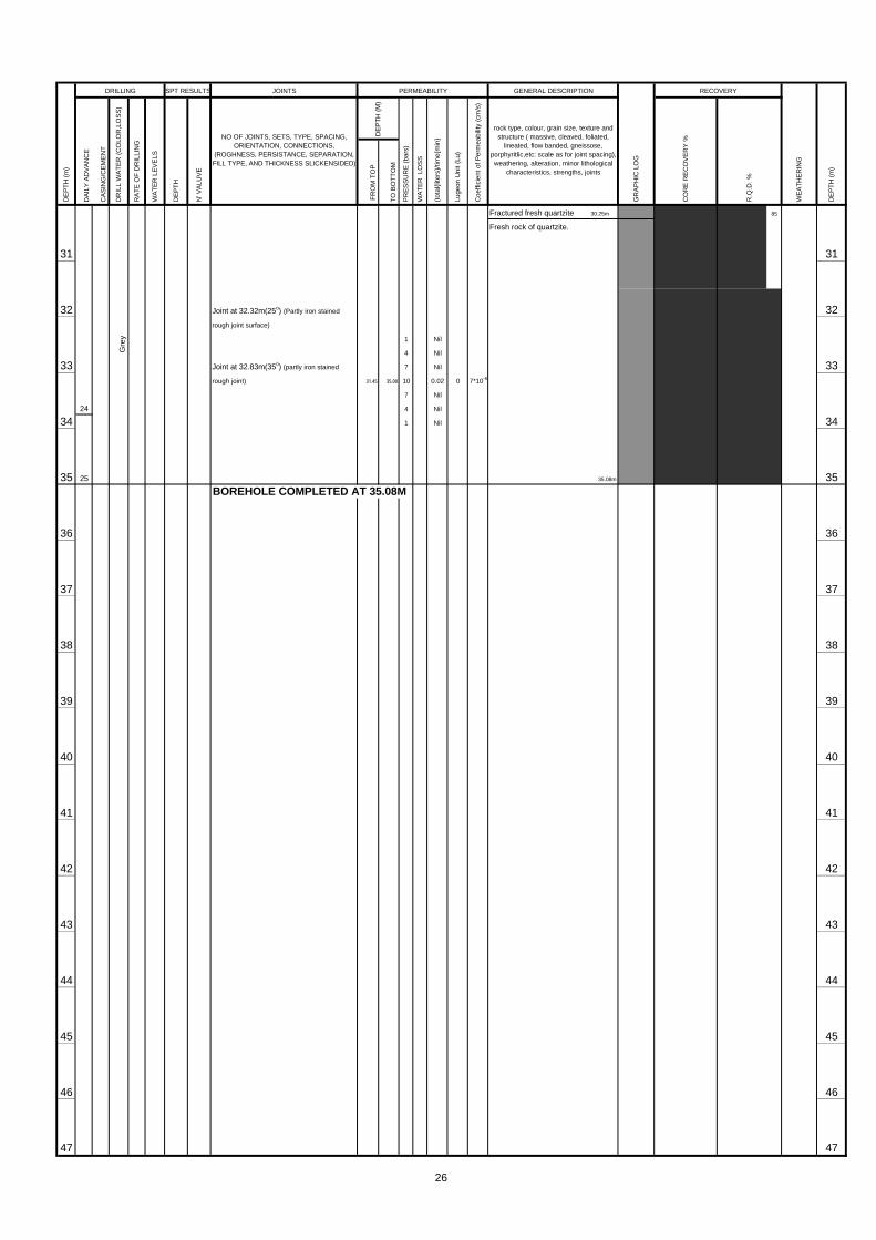
JOINTS D
AIL
Y A
DV
AN
CE
CA
SIN
G/C
EM
EN
T
FR
OM
TO
P
TO
BO
TT
OM
31 31
32 Joint at 32.32m(25o) (Partly iron stained 32rough joint surface)
1 Nil
4 Nil
33 Joint at 32.83m(35o) (partly iron stained 7 Nil 33rough joint) 31.45 35.00 10 0.02 0 7*10-8
7 Nil
24 4 Nil
34 1 Nil 34
35 25 35BOREHOLE COMPLETED AT 35.08M
36 36
37 37
38 38
39 39
40 40
41 41
42 42
43 43
44 44
45 45
46 46
47 47
Fractured fresh quartzite 30.25m
Fresh rock of quartzite.
35.08m
85
DE
PT
H (
m)
WE
ATH
ER
ING
DE
PT
H (
M)
PR
ES
SU
RE
(ba
rs)
DR
ILL
WA
TE
R (
CO
LOR
,LO
SS
)
RA
TE
OF
DR
ILLI
NG
WA
TER
LE
VE
LS
DE
PTH
GR
AP
HIC
LO
G
RECOVERY
rock type, colour, grain size, texture andstructure ( massive, cleaved, foliated,
lineated, flow banded, gneissose,porphyritlic,etc: scale as for joint spacing),weathering, alteration, minor lithological
characteristics, strengths, joints
CO
RE
RE
CO
VE
RY
%
R.Q
.D. %
GENERAL DESCRIPTION
DE
PT
H (
m)
DRILLING SPT RESULTS PERMEABILITY
(tot
al{li
ters
}/tim
e{m
in}
Luge
on U
nit (
Lu)
Coe
ffici
ent o
f Per
mea
bilit
y (c
m/s
)
WA
TE
R L
OS
S
N' V
ALU
VE
NO OF JOINTS, SETS, TYPE, SPACING,ORIENTATION, CONNECTIONS,
(ROGHNESS, PERSISTANCE, SEPARATION,FILL TYPE, AND THICKNESS SLICKENSIDED)
Gre
y
26

BOREHOLE DATA LEGEND FOR GRAPHIC LOGJOINT SEPARATION Sand
V= very tight Clay
T= tight Fresh to slightly weathered charnockite
MO= moderately open Highly to mod weathered charnockite
O= open Fresh to slightly weathered biotite gneiss
Highly to mod weathered biotite gneiss
Quartzite
SL/CW - Soil & Completely Weathered Calc gneiss
HW - Highly Weathered Boulder
MW - Moderately Weathered TCR RQDSW - Slightly Weathered SL/CW
TCR - Total Core Recovery HW
RQD - Rock Quality Designation MW
GWL - Ground water Level SW
JOINTS
DA
ILY
AD
VA
NC
E
CA
SIN
G/C
EM
EN
T
FR
OM
TO
P
TO
BO
TT
OM
0.00
0.45 8
1 1
2 1.95 22.40 54
3 3
4 5.10 3.90 4 29/12 4.15 76HB
28
5 5
6 61 Nil
7.70 4 0.60
3/ 13 7 1.60
7 4.15 9.15 10 4.00 1 1*10-5 77 1.20
29 4 0.50
1 Nil
8 8
9 9
10 10
1 1.00
4 1.50
11 7 1.60 119.15 14.15 10 3.00 1 8*10-6
11.60 7 2.10
4 / 12 4 1.50
12 1 0.90 12
13.10
13 5 / 12 13
GEOLOGICAL INVESTIGATION FOR THE BROADLANDS HYDROPOWER PROJECT
BOREHOLE LOG FOR ENGINEERING PURPOSESG
rey
Reddish brown, dense, silty fine to
coarse sand
3.00m
WEATHERING
WE
ATH
ER
ING
81
75
DE
PT
H (
m)
of biotite gneiss.(Rock in pieces
RA
TE
OF
DR
ILLI
NG
DR
ILL
WA
TE
R (
CO
LOR
, LO
SS
)
DE
PT
H (
M)
PR
ES
SU
RE
(ba
rs)
DE
PT
H (
m)
DRILLING
LOCATION :- PENSTOCK B.H No.: MT 3
GENERAL DESCRIPTION
Rock type, colour, grain size, texture andstructure ( massive, cleaved, foliated,
lineated, flow banded, gneissose,porphyritlic,etc: scale as for joint spacing),weathering, alteration, minor lithological
characteristics, strengths, joints
WA
TER
LE
VE
LS
NO OF JOINTS, SETS, TYPE, SPACING,ORIENTATION, CONNECTIONS,
(ROGHNESS, PERSISTANCE, SEPARATION,FILL TYPE, AND THICKNESS SLICKENSIDED)
N' V
ALU
VE
DE
PTH
SR: slightly rough
S= smotth
W= widely
garnet-quartzo feldspathic gneiss.
5.20m
Moderately to highly weathered rock
DRILLING DATA
VR= very rough
R: rough
VW= very widely> 2mELEVATION (BOTTOM) :52.272m
STARTED :
COMPLETED :
MACHING TYPE :
DRILLING METHOD :
ELEVATION (COLLAR) :77.842m
FOREMAN :
LOGGED BY :
MW= moderately wide
C= Closely
VC= very closely
CORE BARREL, BIT :
BMAPM
FINAL DEPTH :25.57m
INCLINATION : Vertical
X-COORDINATE :161,448.998m
Y-COORDINATE :198,139.480m
WA
TE
R L
OS
S
RECOVERY
CO
RE
RE
CO
VE
RY
%
R.Q
.D. %
JOINT SPACING
Luge
on U
nit (
Lu)
Coe
ffici
ent o
f Per
mea
bilit
y (c
m/s
)
PERMEABILITY
GR
AP
HIC
LO
G
(tot
al{li
ters
}/tim
e{m
in}
KEY
OTHER SYMBOLS
JOINT ROUGHNESS
SL=slickensided
NQ
WLN
4.15m
Highly to moderately weathered
coarse sand with some gravels.
Reddish brown, dense, silty fine to
BEARING : -
SPT RESULTS
7.00m
gneiss.
max.9cm & min.<1cm) 6.00m
Moderately to highly weathered
rock of biotite gneiss. Rock in pieces
Highly to moderately weathered
rock of garnet-quartzo feldspathic
28/11/2002
05/12/2002
TONE
ROTARY
75
94
80
72
75
LABORATORY & SITEINVESTIGATION UNIT
LABORATORY & SITEINVESTIGATION UNIT
27

JOINTS D
AIL
Y A
DV
AN
CE
CA
SIN
G/C
EM
EN
T
FR
OM
TO
P
TO
BO
TT
OM
3
14 14
Joint at 14.80m(40o)
15 (partly weathered joint surface) 15
1 Nil
16 4 1.10 167 1.30
14.15 19.15 10 2.00 0 5*10-6
Joints at 16.81m(15o) &16.90m(20o) 7 1.40
17 (weathered rough joint surfaces) 4 0.90 171 0.40
18 Sub vertical joint at 17.95m to 18.29m 18 (Tight joint)
19 19
biotite gneiss.
20 Vertical joint at 20.09m-20.4m 20(Partly iron stained)
Here the rock is in pieces due to that joint.
4
21 1 Nil 214 Nil
Joint at 21.40m-21.49m(550) 7 Nil
(fresh tight joint) 19.15 24.15 10 0.02 0 5*10-8
22 7 Nil 224 Nil
1 Nil
23 23
24 24
Joint at 24.80m(40o) (fresh tight joint)
Sub vertical joint at 24.80m- 25.50m 24.15 25.50 10 0.00 0 0
25 (Partly tight joint) 25
5
26 26
27 27
28 28
29 29
30 30
Gre
y
RECOVERY
WE
ATH
ER
ING
DE
PT
H (
m)
CO
RE
RE
CO
VE
RY
%
R.Q
.D. %
rock type, colour, grain size, texture andstructure ( massive, cleaved, foliated,
lineated, flow banded, gneissose,porphyritlic,etc: scale as for joint spacing),weathering, alteration, minor lithological
characteristics, strengths, joints
GR
AP
HIC
LO
G
GENERAL DESCRIPTION
DE
PT
H (
M)
PR
ES
SU
RE
(ba
rs)
WA
TE
R L
OS
S
(tot
al{li
ters
}/tim
e{m
in}
DE
PT
H (
m)
DRILLING SPT RESULTS PERMEABILITY
WA
TER
LE
VE
LS
DE
PTH
N' V
ALU
VE
NO OF JOINTS, SETS, TYPE, SPACING,ORIENTATION, CONNECTIONS,
(ROGHNESS, PERSISTANCE, SEPARATION,FILL TYPE, AND THICKNESS SLICKENSIDED)
DR
ILL
WA
TE
R (
CO
LOR
,LO
SS
)
RA
TE
OF
DR
ILLI
NG
Highly to moderately weathered
rock of garnet-quartzo feldspathic
gneiss.
14.00m
Fresh rock of garnet biotite gneiss.
Luge
on U
nit (
Lu)
Coe
ffici
ent o
f Per
mea
bilit
y (c
m/s
)
15.60m
Weathered garnet biotite gneiss 15.85m
Fresh rock of garnet biotite gneiss.
20.00m
Fresh rock of quartz rich garnet
19.00m
Fresh rock of garnet biotite gneiss.
gneiss
24.00m
23.00m
Moderately weathered garnet biotite
Fresh rock of garnet biotite gneiss.
25.57m
BOREHOLE COMPLETED AT 25.57M
80
60
42
49
76
57
68
47
86
28

BOREHOLE DATA LEGEND FOR GRAPHIC LOGJOINT SEPARATION Sand
V= very tight Clay
T= tight Fresh to slightly weathered charnockite
MO= moderately open Highly to mod weathered charnockite
O= open Fresh to slightly weathered biotite gneiss
Highly to mod weathered biotite gneiss
Quartzite
SL/CW - Soil & Completely Weathered Calc gneiss
HW - Highly Weathered Boulder
MW - Moderately Weathered TCR RQDSW - Slightly Weathered SL/CW
TCR - Total Core Recovery HW
RQD - Rock Quality Designation MW
GWL - Ground water Level SW
JOINTS
DA
ILY
AD
VA
NC
E
CA
SIN
G/C
EM
EN
T
FR
OM
TO
P
TO
BO
TT
OM
0.00
0.45 8
1 1
2 1.95 22.40 15
3 3
4 29 3.90 44.35 15
5 5
5.85
6 6.30 27 6
7 77.70
3 / 11
7.80
8 8.25 31 82
9 9
10 10
11 11
12 12
13 13
GEOLOGICAL INVESTIGATION FOR THE BROADLANDS HYDROPOWER PROJECT
BOREHOLE LOG FOR ENGINEERING PURPOSES
29/10/2002
11/11/2002
TONE
ROTARY
available
1.00m
Highly weathered rock in pieces
8.25m
Highly weathered rock of garnet
biotite gneiss
6.00m
Light reddish brown, densed silty,fine
to coarse quartzitic sand with some
pebbles
4.00m
Reddish brown, densed silty,fine to
64
coarse quartzitic sand with some
5.00m
Dark reddish brown, fine sandy
clayey,silt
pebbles
fine to coarse silty sand with some
weathered rock fragments
FINAL DEPTH :30.55m
INCLINATION : Vertical
CORE BARREL, BIT :
Reddish brown, moderately densed
silty sand. Some coarse sand also
Yellowish brown, loose fine to medium
N' V
ALU
VE
DE
PTH
Coe
ffici
ent o
f Per
mea
bilit
y (c
m/s
)
BEARING : -
OTHER SYMBOLS
JOINT ROUGHNESS
SL=slickensided
X-COORDINATE :161,468.184m
Y-COORDINATE :198,200.832m
ELEVATION (BOTTOM) :57.008m
ELEVATION (COLLAR) :87.558m
JOINT SPACING
MW= moderately wide
VW= very widely> 2m
W= widely
VC= very closely
BMAPM
WA
TE
R L
OS
S
KRNK
Luge
on U
nit (
Lu)
SR: slightly rough
S= smotth
PERMEABILITY
DE
PT
H (
M)
PR
ES
SU
RE
(ba
rs)
(tot
al{li
ters
}/tim
e{m
in}
C= Closely
DRILLING DATA
VR= very rough
R: rough
KEY
STARTED :
COMPLETED :
MACHING TYPE :
WA
TER
LE
VE
LS
DRILLING METHOD :
NQ
RA
TE
OF
DR
ILLI
NG
DR
ILL
WA
TE
R (
CO
LOR
, LO
SS
)
FOREMAN :
LOGGED BY :
DE
PT
H (
m)
DE
PT
H (
m)
DRILLING
NO OF JOINTS, SETS, TYPE, SPACING,ORIENTATION, CONNECTIONS,
(ROGHNESS, PERSISTANCE, SEPARATION,FILL TYPE, AND THICKNESS SLICKENSIDED)
GR
AP
HIC
LO
G
RECOVERY
CO
RE
RE
CO
VE
RY
%
R.Q
.D. %
GENERAL DESCRIPTION
Rock type, colour, grain size, texture andstructure ( massive, cleaved, foliated,
lineated, flow banded, gneissose,porphyritlic,etc: scale as for joint spacing),weathering, alteration, minor lithological
characteristics, strengths, joints
LOCATION :- PENSTOCK B.H No.: MT- 4
WEATHERING
WE
ATH
ER
ING
SPT RESULTS
53
68
64
68
Gre
yish
yel
low
LABORATORY & SITEINVESTIGATION UNIT
LABORATORY & SITEINVESTIGATION UNIT
29

JOINTS D
AIL
Y A
DV
AN
CE
CA
SIN
G/C
EM
EN
T
FR
OM
TO
P
TO
BO
TT
OM
14 14
15 1515.30
15.60
8 / 11
16 3 16
16.45
9 ,10,11/ 11
17 4 17Foliation joints at 17.17,17.21,17.31m(500)
(Weathered,rough, joint surfaces)
18 Foliation joint at 18.08m(500) 18(Tight,rough, joint )
19 5 1 Nil 194 0.40
7 0.60
18.30 21.90 10 1.10 0 4*10-6
20 7 0.60 204 0.30
1 0.10
21 8 Foliation joints at 21.08,21.13m(450) 21(Weathered,rough, joint surfaces)
22 22
23 23Sub vertical joint from 23.20m-23.70m
(Tight joint) 1 Nil
Sub vertical joint from 23.79m-23.95m 4 Nil
24 (Tight joint) 7 0.02 2421.90 27.05 10 0.05 0 2*10-7
7 0.02
4 Nil
25 9 1 Nil 25
26 26
27 27
10
28 1 Nil 284 Nil
Foliation joint at 28.87m(420) 7 0.03
(Fresh, tight joint ) 27.05 30.55 10 0.06 0 2*10-7
29 7 0.02 294 Nil
1 Nil
30 30
Few garnets available
Fresh,quartz rich, biotite gneiss
Biotite rich layer from 25.43-26.60m
20.92m
Fresh rock of biotite gneiss
Few garnets available
From 21.00 to 21.70m biotite% is high
biotite gneiss, Rock in pieces54
Highly weathered rock of biotite
82
78
gneiss
18.48m
Highly weathered rock of garnet
RA
TE
OF
DR
ILLI
NG
Highly weathered rock of garnet
biotite gneiss
Highly weathered rock in pieces
Luge
on U
nit (
Lu)
DE
PT
H (
M)
PR
ES
SU
RE
(ba
rs)
DE
PT
H (
m)
DRILLING SPT RESULTS PERMEABILITY
WA
TER
LE
VE
LS
DE
PTH
N' V
ALU
VE
NO OF JOINTS, SETS, TYPE, SPACING,ORIENTATION, CONNECTIONS,
(ROGHNESS, PERSISTANCE, SEPARATION,FILL TYPE, AND THICKNESS SLICKENSIDED)
WA
TE
R L
OS
S
(tot
al{li
ters
}/tim
e{m
in}
Coe
ffici
ent o
f Per
mea
bilit
y (c
m/s
)
RECOVERY
WE
ATH
ER
ING
DE
PT
H (
m)
CO
RE
RE
CO
VE
RY
%
R.Q
.D. %
rock type, colour, grain size, texture andstructure ( massive, cleaved, foliated,
lineated, flow banded, gneissose,porphyritlic,etc: scale as for joint spacing),weathering, alteration, minor lithological
characteristics, strengths, joints
GR
AP
HIC
LO
G
GENERAL DESCRIPTION
70
60
60
70
gneiss, Rock in pieces
25
40
82 39
16.27m
Moderately weathered rock of biotite
Gre
yish
yel
low
Whi
tish
grey
DR
ILL
WA
TE
R (
CO
LOR
,LO
SS
)
30

JOINTS D
AIL
Y A
DV
AN
CE
CA
SIN
G/C
EM
EN
T
FR
OM
TO
P
TO
BO
TT
OM
11
31 31
32 32
33 33
34 34
35 35
36 36
37 37
38 38
39 39
40 40
41 41
42 42
43 43
44 44
45 45
46 46
47 47
Fresh,quartz rich, biotite gneiss
30.55m
BOREHOLE COMPLETED AT 30.55M
DE
PT
H (
m)
DR
ILL
WA
TE
R (
CO
LOR
,LO
SS
)
RA
TE
OF
DR
ILLI
NG
WA
TER
LE
VE
LS
DE
PTH
N' V
ALU
VE
NO OF JOINTS, SETS, TYPE, SPACING,ORIENTATION, CONNECTIONS,
(ROGHNESS, PERSISTANCE, SEPARATION,FILL TYPE, AND THICKNESS SLICKENSIDED)
DE
PT
H (
M)
PR
ES
SU
RE
(ba
rs)
WA
TE
R L
OS
S
GENERAL DESCRIPTION
GR
AP
HIC
LO
G
RECOVERY
WE
ATH
ER
ING
rock type, colour, grain size, texture andstructure ( massive, cleaved, foliated,
lineated, flow banded, gneissose,porphyritlic,etc: scale as for joint spacing),weathering, alteration, minor lithological
characteristics, strengths, joints
CO
RE
RE
CO
VE
RY
%
R.Q
.D. %
DE
PT
H (
m)
DRILLING SPT RESULTS PERMEABILITY
(tot
al{li
ters
}/tim
e{m
in}
Luge
on U
nit (
Lu)
Coe
ffici
ent o
f Per
mea
bilit
y (c
m/s
)
Whi
tish
grey
31

BOREHOLE DATA LEGEND FOR GRAPHIC LOGJOINT ROUGHNESS JOINT SEPARATION Sand
V= very tight Decomposed mica
T= tight Garnet biotite gneiss
MO= moderately open Quartzo feldspathic gneiss
O= open Charnockite
Granitic Gneiss
Quartzite
SL/CW - Soil & Completely Weathered Calc gneiss/Crystalline Lime stone
HW - Highly Weathered Calc gneiss
MW - Moderately Weathered TCR RQDSW - Slightly Weathered SL/CW
TCR - Total Core Recovery HW
RQD - Rock Quality Designation MW
GWL - Ground water Level SW
JOINTS
SP
T V
ALU
ES
DE
PT
H(m
)
N' V
ALU
E
FR
OM
TO
P
TO
BO
TT
OM
Fine to coarse grained,moderate
dense,brown,clayey silty sand
1 Fresh charnockitic gneiss 1(Boulder)
2 2
3 3
4 4
5 5
6 6
7 7
7
8 8
9 9
10 10
11 11
12 12
13 13
GEOLOGICAL INVESTIGATION FOR THE BROADLANDS HYDROPOWER PROJECT
BOREHOLE LOG FOR ENGINEERING PURPOSESLOCATION :- Divertion Tunnel B.H No.:DT 2 Page 1 of 4
DRILLING DATA KEY
STARTED : 2003/7/7 X-COORDINATE :164,804.155mVR= very rough
COMPLETED : 2003/12/7 Y-COORDINATE :197,605.418mR: rough
SR: slightly rough
JOINT SPACING
MACHINE TYPE : TONE ELEVATION (COLLAR) :139.440mS= smotth
SL=slickensided
OTHER SYMBOLS
VW= very widely> 2m
CORE BARREL, BIT : NX FINAL DEPTH :60.00mW= widely
MW= moderately wide
DRILLING METHOD : ROTARY ELEVATION (BOTTOM) :
WEATHERING
FOREMAN : MRAMHP INCLINATION : Angle 450C= Closely
VC= very closely
LOGGED BY : SRMS/RMLKR BEARING :
DE
PT
H (
m)
DRILLING PERMEABILITY GENERAL DESCRIPTION
DA
ILY
AD
VA
NC
E
CA
SIN
G/C
EM
EN
T
DR
ILL
WA
TE
R (
CO
LOU
R, L
OS
S)
RA
TE
OF
DR
ILLI
NG
WA
TE
R L
EV
ELS
NO OF JOINTS, SETS, TYPE, SPACING,ORIENTATION, CONNECTIONS,(ROUGHNESS, PERSISTENCE,SEPARATION, FILL TYPE, ANDTHICKNESS SLICKENSIDED)
MO
SA
IC L
OG
RECOVERY
WE
AT
HE
RIN
G
DE
PT
H (
m)
CO
RE
RE
CO
VE
RY
%
R.Q
.D. %
DE
PT
H (
M)
PR
ES
SU
RE
(B
AR
S)
MA
NO
ME
TE
R R
EA
DIN
G
WA
TE
R L
OS
S
(tot
al{li
ters
}/tim
e{m
in}
Luge
on U
nit (
Lu)
Coe
ffici
ent o
f Per
mea
bilit
y (c
m/s
)
Rock type, colour, grain size, texture andstructure ( massive, cleaved, foliated, lineated,flow banded, gneissose, porphyritlic,etc: scale
as for joint spacing), weathering, alteration,minor lithological characteristics, strengths,
joints
Bro
wn
Gre
y
(Some gravels available) (Top soil layer) 0.52
81
1.55
8.3208/07
13.00
Bro
wn
Fine to medium grained, brown sand
(Sludge sample)
LABORATORY & SITEINVESTIGATION UNIT
32

JOINTS
SP
T V
ALU
ES
DA
ILY
AD
VA
NC
E
CA
SIN
G/C
EM
EN
T
RA
TE
OF
DR
ILLI
NG
DE
PT
H(m
)
N' V
ALU
E
FR
OM
TO
P
TO
BO
TT
OM
14 14
15 15
16 16
17 17
18 18
19 19
20 8 20
21 21
22 22
23 23
24 24
25 25
26 26
27 27
28 28
29 29
30 30.00 30
FEASIBILITY STUDY OF THE BROADLANDS HYDRO POWER PROJECT BOREHOLE LOG FOR ENGINEERING PURPOSES
LOCATION :- Divertion Tunnel B.H No.:DT 2 Page 2 of 4
DE
PT
H (
m)
DRILLING PERMEABILITY GENERAL DESCRIPTION
MO
SA
IC L
OG
RECOVERY
WE
AT
HE
RIN
G
DE
PT
H (
m)
DR
ILL
WA
TE
R (
CO
LOR
,LO
SS
)
WA
TE
R L
EV
ELS
NO OF JOINTS, SETS, TYPE, SPACING,ORIENTATION, CONNECTIONS,(ROGHNESS, PERSISTANCE,
SEPARATION, FILL TYPE, ANDTHICKNESS SLICKENSIDED)
DE
PT
H (
M)
PR
ES
SU
RE
(ba
rs)
Man
omet
er R
eadi
ng
WA
TE
R L
OS
S
(tot
al{li
ters
}/tim
e{m
in}
Luge
on U
nit (
Lu)
Coe
ffici
ent o
f Per
mea
bilit
y (c
m/s
)
ROCK TYPE, COLOUR, GRAIN SIZE,TEXTURE AND STRUCTURE (MASSIVE,CLEAVED, FOLIATED, LINEATED, FLOWBANDED, GNEISSOSE, PORPHYRITIC,ECT: SCALE AS FOR JOINT SPACING),
WEATHERING,ALTERATION,MINORLITHOLOGICAL CHARACTERISTICS,
STRENGTH,JOINTS
CO
RE
RE
CO
VE
RY
%
R.Q
.D. %
Bro
wn Fine to medium grained, brown sand
(Sludge sample)
13.72
Gre
yish
bro
wn
Fine grained, brown sand
(Mica & weathered feldspar available)
(Insitu formation)
(Sludge sample)
(Highly decomposed material)
15.2409/07
Ligh
t bro
wn
Gre
yish
bro
wn
20.4812/07
LABORATORY & SITEINVESTIGATION
UNIT
33

JOINTS
SP
T V
ALU
ES
DA
ILY
AD
VA
NC
E
CA
SIN
G/C
EM
EN
T
RA
TE
OF
DR
ILLI
NG
DE
PT
H(m
)
N' V
ALU
E
FR
OM
TO
P
TO
BO
TT
OM
9 30.12
31 31
32 32
33 33
34 34
35 35
36 36
37 37
38 38
39 39
40 40
41 41
42 42
43 43
44 44
45 45
46 11 46
47 47.00 47
FEASIBILITY STUDY OF THE BROADLANDS HYDRO POWER PROJECT BOREHOLE LOG FOR ENGINEERING PURPOSES
LOCATION :- Divertion Tunnel B.H No.:DT 2 Page 3 of 4
DE
PT
H (
m)
DRILLING PERMEABILITY GENERAL DESCRIPTIOND
RIL
L W
AT
ER
(C
OLO
R,L
OS
S)
WA
TE
R L
EV
ELS
NO OF JOINTS, SETS, TYPE, SPACING,ORIENTATION, CONNECTIONS,(ROGHNESS, PERSISTANCE,
SEPARATION, FILL TYPE, ANDTHICKNESS SLICKENSIDED)
DE
PT
H (
M)
PR
ES
SU
RE
(ba
rs)
Man
omet
er R
eadi
ng
MO
SA
IC L
OG
RECOVERY
WE
AT
HE
RIN
G
DE
PT
H (
m)
WA
TE
R L
OS
S
(tot
al{li
ters
}/tim
e{m
in}
Luge
on U
nit (
Lu)
Coe
ffici
ent o
f Per
mea
bilit
y (c
m/s
)
ROCK TYPE, COLOUR, GRAIN SIZE,TEXTURE AND STRUCTURE (MASSIVE,CLEAVED, FOLIATED, LINEATED, FLOWBANDED, GNEISSOSE, PORPHYRITIC,ECT: SCALE AS FOR JOINT SPACING),
WEATHERING,ALTERATION,MINORLITHOLOGICAL CHARACTERISTICS,
STRENGTH,JOINTS
CO
RE
RE
CO
VE
RY
%
R.Q
.D. %
Gre
yish
bro
wn
Fine grained, brown sand
(Mica & weathered feldspar available)
(Insitu formation)
(Sludge sample)
(Highly decomposed material)
34.00
Fine grained, brown sand
(Mica & weathered feldspar available
high % of micas) (Insitu formation)
(Sludge sample)
(Highly decomposed material)
40.03
Brown mica layer
(Flackey grains) (Sludge sample)
(Highly decomposed material)
Red
ish
brow
n
LABORATORY & SITEINVESTIGATION
UNIT
34

JOINTS
SP
T V
ALU
ES
DA
ILY
AD
VA
NC
E
CA
SIN
G/C
EM
EN
T
RA
TE
OF
DR
ILLI
NG
DE
PT
H(m
)
N' V
ALU
E
FR
OM
TO
P
TO
BO
TT
OM
48 48
49 49
50 50
51 51
52 52
53 53
54 54
55 55
56 56
57 57
58 58
59 59
60 12 60.00 60
61 61
62 62
63 63
64 64
FEASIBILITY STUDY OF THE BROADLANDS HYDRO POWER PROJECT BOREHOLE LOG FOR ENGINEERING PURPOSES
LOCATION :- Divertion Tunnel B.H No.:DT 2 Page 4 of 4
DE
PT
H (
m)
DRILLING PERMEABILITY GENERAL DESCRIPTION
MO
SA
IC L
OG
RECOVERY
WE
AT
HE
RIN
G
DE
PT
H (
m)
DR
ILL
WA
TE
R (
CO
LOR
,LO
SS
)
WA
TE
R L
EV
ELS
NO OF JOINTS, SETS, TYPE, SPACING,ORIENTATION, CONNECTIONS,(ROGHNESS, PERSISTANCE,
SEPARATION, FILL TYPE, ANDTHICKNESS SLICKENSIDED)
DE
PT
H (
M)
PR
ES
SU
RE
(ba
rs)
Man
omet
er R
eadi
ng
WA
TE
R L
OS
S
(tot
al{li
ters
}/tim
e{m
in}
Luge
on U
nit (
Lu)
Coe
ffici
ent o
f Per
mea
bilit
y (c
m/s
)
ROCK TYPE, COLOUR, GRAIN SIZE,TEXTURE AND STRUCTURE (MASSIVE,CLEAVED, FOLIATED, LINEATED, FLOWBANDED, GNEISSOSE, PORPHYRITIC,ECT: SCALE AS FOR JOINT SPACING),
WEATHERING,ALTERATION,MINORLITHOLOGICAL CHARACTERISTICS,
STRENGTH,JOINTS
CO
RE
RE
CO
VE
RY
%
R.Q
.D. %
Bore hole completed at 60.00m
Red
ish
brow
n
Brown mica layer
(Flackey grains) (Sludge sample)
(Highly decomposed material)
53.00
Reddish brownish mica layer
(Flackey grains) (Sludge sample)
(Highly decomposed material)
LABORATORY & SITEINVESTIGATION
UNIT
35
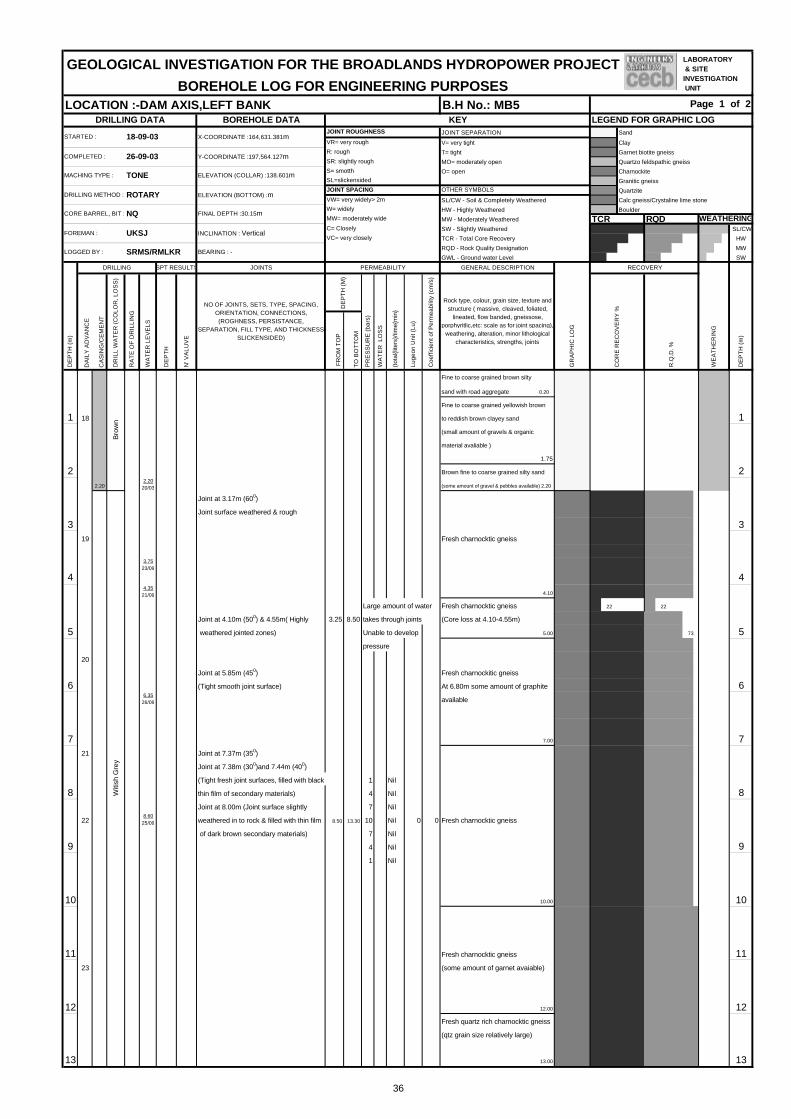
BOREHOLE DATA LEGEND FOR GRAPHIC LOGJOINT SEPARATION Sand
V= very tight Clay
T= tight Garnet biotite gneiss
MO= moderately open Quartzo feldspathic gneiss
O= open Charnockite
Granitic gneiss
Quartzite
SL/CW - Soil & Completely Weathered Calc gneiss/Crystaline lime stone
HW - Highly Weathered Boulder
MW - Moderately Weathered TCR RQDSW - Slightly Weathered SL/CW
TCR - Total Core Recovery HW
RQD - Rock Quality Designation MW
GWL - Ground water Level SW
JOINTS
DA
ILY
AD
VA
NC
E
CA
SIN
G/C
EM
EN
T
FR
OM
TO
P
TO
BO
TT
OM
1 18 1
2 22.20
2.2020/03 (some amount of gravel & pebbles available) 2.20
Joint at 3.17m (600)
Joint surface weathered & rough
3 319
3.7523/09
4 44.35
21/09
Large amount of water
Joint at 4.10m (500) & 4.55m( Highly 3.25 8.50 takes through joints
5 weathered jointed zones) Unable to develop 5pressure
20
Joint at 5.85m (450)
6 (Tight smooth joint surface) 66.35
26/09 available
7 721 Joint at 7.37m (350)
Joint at 7.38m (300)and 7.44m (400)
(Tight fresh joint surfaces, filled with black 1 Nil
8 thin film of secondary materials) 4 Nil 8Joint at 8.00m (Joint surface slightly 7 Nil
228.60
25/09 weathered in to rock & filled with thin film 8.50 13.30 10 Nil 0 0
of dark brown secondary materials) 7 Nil
9 4 Nil 91 Nil
10 10
11 1123
12 12
13 13
GEOLOGICAL INVESTIGATION FOR THE BROADLANDS HYDROPOWER PROJECT
BOREHOLE LOG FOR ENGINEERING PURPOSESLOCATION :-DAM AXIS,LEFT BANK B.H No.: MB5 Page 1 of 2
DRILLING DATA KEY
STARTED : 18-09-03 X-COORDINATE :164,631.381mJOINT ROUGHNESS
VR= very rough
COMPLETED : 26-09-03 Y-COORDINATE :197,564.127mR: rough
SR: slightly rough
JOINT SPACING
MACHING TYPE : TONE ELEVATION (COLLAR) :138.601mS= smotth
SL=slickensided
OTHER SYMBOLS
VW= very widely> 2m
CORE BARREL, BIT : NQ FINAL DEPTH :30.15mW= widely
MW= moderately wide
DRILLING METHOD : ROTARY ELEVATION (BOTTOM) :m
WEATHERING
FOREMAN : UKSJ INCLINATION : VerticalC= Closely
VC= very closely
LOGGED BY : SRMS/RMLKR BEARING : -
DE
PT
H (
m)
DRILLING SPT RESULTS PERMEABILITY
(tot
al{li
ters
}/tim
e{m
in}
Luge
on U
nit (
Lu)
Coe
ffici
ent o
f Per
mea
bilit
y (c
m/s
)
PR
ES
SU
RE
(ba
rs)
WA
TE
R L
OS
S
RECOVERY
WE
AT
HE
RIN
G
Rock type, colour, grain size, texture andstructure ( massive, cleaved, foliated,
lineated, flow banded, gneissose,porphyritlic,etc: scale as for joint spacing),
weathering, alteration, minor lithologicalcharacteristics, strengths, joints
CO
RE
RE
CO
VE
RY
%
R.Q
.D. %
GENERAL DESCRIPTION
GR
AP
HIC
LO
G
1.75
Brown fine to coarse grained silty sand
DE
PT
H (
m)
DR
ILL
WA
TE
R (
CO
LOR
, LO
SS
)
RA
TE
OF
DR
ILLI
NG
WA
TE
R L
EV
ELS
DE
PT
H
N' V
ALU
VE
NO OF JOINTS, SETS, TYPE, SPACING,ORIENTATION, CONNECTIONS,(ROGHNESS, PERSISTANCE,
SEPARATION, FILL TYPE, AND THICKNESSSLICKENSIDED)
DE
PT
H (
M)
4.10
Bro
wn
Fine to coarse grained brown silty
sand with road aggregate 0.20
Fine to coarse grained yellowish brown
to reddish brown clayey sand
(small amount of gravels & organic
material avaliable )
Fresh charnocktic gneiss
Fresh charnocktic gneiss 22 22
(Core loss at 4.10-4.55m)
5.00 73
Fresh charnockitic gneiss
At 6.80m some amount of graphite
7.00
Fresh charnocktic gneiss
10.00
Fresh charnocktic gneiss
(some amount of garnet avaiable)
12.00
Fresh quartz rich charnocktic gneiss
(qtz grain size relatively large)
13.00
Witi
sh G
rey
LABORATORY & SITEINVESTIGATION UNIT
LABORATORY & SITEINVESTIGATION UNIT
LABORATORY & SITEINVESTIGATION UNIT
LABORATORY & SITEINVESTIGATION UNIT
LABORATORY & SITEINVESTIGATION UNIT
LABORATORY & SITEINVESTIGATION UNIT
36

JOINTS
DA
ILY
AD
VA
NC
E
CA
SIN
G/C
EM
EN
T
FR
OM
TO
P
TO
BO
TT
OM
Joint at 13.78m(400)
((Tight joint filled with thin film
of grey and black secondary materials)
14 14
15 1 Nil 154 Nil
7 Nil
13.50 19.20 10 Nil 0 0
16 7 Nil 164 Nil
1 Nil
17 17
24
18 18
19 19
20 20
1 3.3
21 4 5.7 217 7.3
19.50 25.50 10 10.6 2 10-5
7 7.7
22 4 6.1 221 3.4
23 23
24 24
25
25 25
26 26
27 27
28 28
29 29
30 26 30
GEOLOGICAL INVESTIGATION FOR THE BROADLANDS HYDROPOWER PROJECT
BOREHOLE LOG FOR ENGINEERING PURPOSESLOCATION :-DAM AXIS,LEFT BANK B.H No.:MB5 Page 2 of 2
DE
PT
H (
m)
DRILLING SPT RESULTS PERMEABILITY
(tot
al{li
ters
}/tim
e{m
in}
Luge
on U
nit (
Lu)
Coe
ffici
ent o
f Per
mea
bilit
y (c
m/s
)
WA
TE
R L
OS
S
N' V
ALU
VE
NO OF JOINTS, SETS, TYPE, SPACING,ORIENTATION, CONNECTIONS,(ROGHNESS, PERSISTANCE,
SEPARATION, FILL TYPE, AND THICKNESSSLICKENSIDED)
GR
AP
HIC
LO
G
RECOVERY
rock type, colour, grain size, texture andstructure ( massive, cleaved, foliated,
lineated, flow banded, gneissose,porphyritlic,etc: scale as for joint spacing),
weathering, alteration, minor lithologicalcharacteristics, strengths, joints
CO
RE
RE
CO
VE
RY
%
R.Q
.D. %
DE
PT
H (
M)
PR
ES
SU
RE
(ba
rs)
DR
ILL
WA
TE
R (
CO
LOR
,LO
SS
)
RA
TE
OF
DR
ILLI
NG
WA
TE
R L
EV
ELS
DE
PT
H
DE
PT
H (
m)
WE
AT
HE
RIN
G
(qtz grain size relatively large)
GENERAL DESCRIPTION
16.00
Fresh quartz rich garnet biotite
gneiss
23.84
16
Fresh garnet biotite gneiss 82
26.00
Fresh quartz rich garnet biotite
gneiss
(relatively quartz % high)
30.15
Bore hole completed at 30.15m
Whi
tish
brow
n
Fresh quartz rich charnocktic gneiss
LABORATORY & SITEINVESTIGATION UNIT
LABORATORY & SITEINVESTIGATION UNIT
LABORATORY & SITEINVESTIGATION UNIT
37

BOREHOLE DATA LEGEND FOR GRAPHIC LOGJOINT SEPARATION Sand
V= very tight Clay
T= tight Garnet biotite gneiss
MO= moderately open Quartzo feldspathic gneiss
O= open Charnockite
Granitic gneiss
Quartzite
SL/CW - Soil & Completely Weathered Calc gneiss/ Crystaline lime stone
HW - Highly Weathered Boulder
MW - Moderately Weathered TCR RQDSW - Slightly Weathered SL/CW
TCR - Total Core Recovery HW
RQD - Rock Quality Designation MW
GWL - Ground water Level HB -Hammer bounced SW
JOINTS
DA
ILY
AD
VA
NC
E
CA
SIN
G/C
EM
EN
T
FR
OM
TO
P
TO
BO
TT
OM
1 1
1.50
1.95 5
2 2
3 3.00 >5 33.15 HB
3.5029/9
4 428
4.601/10
5 5
6 6
7 7
8 8
9 9
10 10
11 11
12 12
13 13
GEOLOGICAL INVESTIGATION FOR THE BROADLANDS HYDROPOWER PROJECT
BOREHOLE LOG FOR ENGINEERING PURPOSESPage 1 of 2LOCATION :- CONDUIT TRACE BH No: CT 3
DRILLING DATA KEY
STARTED : 2003/9/28 X-COORDINATE :164,465.645mJOINT ROUGHNESS
VR= very rough
COMPLETED : 2003/10/1 Y-COORDINATE :197,713.476mR: rough
SR: slightly rough
JOINT SPACING
MACHING TYPE : TONE ELEVATION (COLLAR) :106.730mS= smotth
SL=slickensided
OTHER SYMBOLS
VW= very widely> 2m
CORE BARREL, BIT : NQ FINAL DEPTH : 20.35 mW= widely
MW= moderately wide
DRILLING METHOD : ROTARY ELEVATION (BOTTOM) :m
LOGGED BY : SRMS/RMLKR BEARING : -
WEATHERING
FOREMAN : UKSJ INCLINATION : VerticalC= Closely
VC= very closely
DE
PT
H (
m)
DRILLING SPT RESULTS PERMEABILITY
(tot
al{li
ters
}/tim
e{m
in}
Luge
on U
nit (
Lu)
Coe
ffici
ent o
f Per
mea
bilit
y (c
m/s
)
WE
AT
HE
RIN
G
Rock type, colour, grain size, texture andstructure ( massive, cleaved, foliated, lineated,flow banded, gneissose, porphyritlic,etc: scale
as for joint spacing), weathering, alteration,minor lithological characteristics, strengths,
joints
CO
RE
RE
CO
VE
RY
%
R.Q
.D. %
DE
PT
H (
m)
DR
ILL
WA
TE
R (
CO
LOR
, LO
SS
)
RA
TE
OF
DR
ILLI
NG
WA
TE
R L
EV
ELS
DE
PT
H
N' V
ALU
VE
NO OF JOINTS, SETS, TYPE, SPACING,ORIENTATION, CONNECTIONS,(ROGHNESS, PERSISTANCE,
SEPARATION, FILL TYPE, ANDTHICKNESS SLICKENSIDED)
DE
PT
H (
M)
PR
ES
SU
RE
(ba
rs)
WA
TE
R L
OS
S
Fine to coarse grained, brown,
clayey silty sand
(Some large rock fragments
avilable, may be broken pieces
of boulder)
3.33
Boulder (Garnet biotite gneiss) 3.40
Fine to coarse grained, light brown,
silty sand (Some gravels and
rock fragments avilable) 4.20
Fresh to highly weathered garnet
biotite gneiss (Boulder)
5.70
Fine to medium grained, brown,
silty sand (Sludge sample)
(Some large rock fragments avilable,
may be broken pieces of boulder)
(Some weathered micas available)
7.25
Fine to coarse grained,brown,silty sand
(Some gravels and rock fragments
avilable) 8.00
Fine to medium grained, brown,
silty sand (Sludge sample)
(Some weathered micas available)
Fine to medium grained, brown,silty
12.00
sand (Sludge sample)
(Some gravels and rock fragments
available) 13.00
95
75
Fine to medium grained, yewllowish
brown,silty sand (Top soil layer) 0.30
Boulder (Fresh gneissic rock) 0.50
GENERAL DESCRIPTION
GR
AP
HIC
LO
G
RECOVERY
Pal
e br
own
50
LABORATORY & SITEINVESTIGATION UNIT
LABORATORY & SITEINVESTIGATION UNIT
LABORATORY & SITEINVESTIGATION UNIT
LABORATORY & SITEINVESTIGATION UNIT
LABORATORY & SITEINVESTIGATION UNIT
LABORATORY & SITEINVESTIGATION UNIT
LABORATORY & SITEINVESTIGATION UNIT
LABORATORY & SITEINVESTIGATION UNIT
LABORATORY & SITEINVESTIGATION UNIT
38

JOINTS
DA
ILY
AD
VA
NC
E
CA
SIN
G/C
EM
EN
T
FR
OM
TO
P
TO
BO
TT
OM
29
14 14
15 15.00 >15 1515.05 HB
16 16
17 16.95 17
18 30 18
(Due to joints and weathering rock
broken into pieces,could'n determine
19 exact positions of the joints due to 19core loss)
20 201
21 21
22 22
23 23
24 24
25 25
26 26
27 27
28 28
29 29
30 30
Fine to medium grained, brown,silty
GENERAL DESCRIPTION
sand (Sludge sample)
14.00
Fine to medium grained, brown,silty
sand
15.00
Fine to medium grained, brown,silty
sand
(Some gravels and large rock
fragments avilable)
16.95
Slightly to moderately weathered
Moderately to highly weathered
crystaline lime stone
(Some hornblende,biotite and diopsite
available) 18.00
Fresh to highly weathered
crystaline lime stone
(Some amount of weathered micas
available)
20.35
Bore Hole completed at 20.35m
WE
AT
HE
RIN
G
DE
PT
H (
m)
R.Q
.D. %
GEOLOGICAL INVESTIGATION FOR THE BROADLANDS HYDROPOWER PROJECT
BOREHOLE LOG FOR ENGINEERING PURPOSESLOCATION :- CONDUIT TRACE B.H No.: CT 3 Page 2 of 2
DE
PT
H (
m)
DRILLING SPT RESULTS PERMEABILITY
DR
ILL
WA
TE
R (
CO
LOR
,LO
SS
)
RA
TE
OF
DR
ILLI
NG
WA
TE
R L
EV
ELS
DE
PT
H (
M)
N' V
ALU
VE
NO OF JOINTS, SETS, TYPE, SPACING,ORIENTATION, CONNECTIONS,(ROGHNESS, PERSISTANCE,
SEPARATION, FILL TYPE, ANDTHICKNESS SLICKENSIDED)
27
Coe
ffici
ent o
f Per
mea
bilit
y (c
m/s
)
rock type, colour, grain size, texture andstructure ( massive, cleaved, foliated, lineated,flow banded, gneissose, porphyritlic,etc: scale
as for joint spacing), weathering, alteration,minor lithological characteristics, strengths,
joints
CO
RE
RE
CO
VE
RY
%
GR
AP
HIC
LO
G
RECOVERY
crystaline lime stone
(Some hornblende and micas available)
19.00
Bro
wn
Ligh
t gre
y to
bro
wn
50
PR
ES
SU
RE
(ba
rs)
WA
TE
R L
OS
S
(tot
al{li
ters
}/tim
e{m
in}
Luge
on U
nit (
Lu)
DE
PT
H
74 35
48
LABORATORY & SITEINVESTIGATION UNIT
LABORATORY & SITEINVESTIGATION UNIT
LABORATORY & SITEINVESTIGATION UNIT
39

BOREHOLE DATA LEGEND FOR GRAPHIC LOGJOINT SEPARATION Sand
V= very tight Clay
T= tight Garnet biotite gneiss
MO= moderately open Quartzo feldspathic gneiss
O= open Charnockite
Granitic gneiss
Quartzite
SL/CW - Soil & Completely Weathered Calc gneiss/Crystaline lime stone
HW - Highly Weathered Boulder
MW - Moderately Weathered TCR RQDSW - Slightly Weathered SL/CW
TCR - Total Core Recovery HW
RQD - Rock Quality Designation MW
GWL - Ground water Level SW
JOINTS
DA
ILY
AD
VA
NC
E
CA
SIN
G/C
EM
EN
T
FR
OM
TO
P
TO
BO
TT
OM
Fine to coarse grained,brown clayey 0.407/10
1 1
1.50
1.95 1
2 22.2
10/10
3 3.00 33.45 7
7
4 4
5 5
6 6 66.45 9
7 7
8 7.50
7.95 8
8 8Fine to coarse grained, light brown
clayey silty sand
Weathered feldspars & micas
9 9.00 99.45 20
10 10
10.50
10.95 17
11 11
(Highly decomposed material)
12 12.00 1212.45 23
9
13 13
GEOLOGICAL INVESTIGATION FOR THE BROADLANDS HYDROPOWER PROJECT
BOREHOLE LOG FOR ENGINEERING PURPOSESLOCATION :-CONDUTE TRACE B.H No.: CT4 Page 1 of 2
DRILLING DATA KEY
STARTED : 2003/10/7 X-COORDINATE :164261.681mJOINT ROUGHNESS
VR= very rough
COMPLETED : 2003/10/11 Y-COORDINATE :197938.506mR: rough
SR: slightly rough
JOINT SPACING
MACHING TYPE : TONE ELEVATION (COLLAR) :103.040mS= smotth
SL=slickensided
OTHER SYMBOLS
VW= very widely> 2m
CORE BARREL, BIT : NQ FINAL DEPTH :20.00mW= widely
MW= moderately wide
DRILLING METHOD : ROTARY ELEVATION (BOTTOM) :m
WEATHERING
FOREMAN : UKSJ INCLINATION : VerticalC= Closely
VC= very closely
LOGGED BY : SRMS/RMLKR BEARING : -
DE
PT
H (
m)
DRILLING SPT RESULTS PERMEABILITY
(tot
al{li
ters
}/tim
e{m
in}
Luge
on U
nit (
Lu)
Coe
ffici
ent o
f Per
mea
bilit
y (c
m/s
)
GENERAL DESCRIPTION
GR
AP
HIC
LO
G
RECOVERY
WE
AT
HE
RIN
G
Rock type, colour, grain size, texture andstructure ( massive, cleaved, foliated,
lineated, flow banded, gneissose,porphyritlic,etc: scale as for joint spacing),
weathering, alteration, minor lithologicalcharacteristics, strengths, joints
CO
RE
RE
CO
VE
RY
%
R.Q
.D. %
DE
PT
H (
m)
DR
ILL
WA
TE
R (
CO
LOR
, LO
SS
)
RA
TE
OF
DR
ILLI
NG
WA
TE
R L
EV
ELS
DE
PT
H
N' V
ALU
VE
NO OF JOINTS, SETS, TYPE, SPACING,ORIENTATION, CONNECTIONS,(ROGHNESS, PERSISTANCE,
SEPARATION, FILL TYPE, AND THICKNESSSLICKENSIDED)
DE
PT
H (
M)
PR
ES
SU
RE
(ba
rs)
WA
TE
R L
OS
S
silty sand
Some amount of gravels & rock
fragments available
1.50
Fine to coarse grained, yellowish
brown clayey silty gravelly sand 2.00
Fine to coarse grained, yellowish
brown clayey silty sand
Some rock fragments & coarse
gravels available
8.00
available
(Highly decomposed material)
9.50
Light brown to white clayey sandy
silt. Weathered feldspars & micas
available
13.00
LABORATORY & SITEINVESTIGATION UNIT
LABORATORY & SITEINVESTIGATION UNIT
LABORATORY & SITEINVESTIGATION UNIT
LABORATORY & SITEINVESTIGATION UNIT
LABORATORY & SITEINVESTIGATION UNIT
LABORATORY & SITEINVESTIGATION UNIT
LABORATORY & SITEINVESTIGATION UNIT
LABORATORY & SITEINVESTIGATION UNIT
LABORATORY & SITEINVESTIGATION UNIT
40

JOINTS
DA
ILY
AD
VA
NC
E
CA
SIN
G/C
EM
EN
T
FR
OM
TO
P
TO
BO
TT
OM
14 14.00 (Highly decomposed material) 1414.45 11
15 15(Highly decomposed material)
16 16.00 1616.45 11
17 17
(Highly decomposed material)
18 1810 18.3
19 19
20 11 20
21 21
22 22
23 23
24 24
25 25
26 26
27 27
28 28
29 29
30 30
GEOLOGICAL INVESTIGATION FOR THE BROADLANDS HYDROPOWER PROJECT
BOREHOLE LOG FOR ENGINEERING PURPOSESLOCATION :-CONDUTE TRACE B.H No.: CT4 Page 2 of 2
DE
PT
H (
m)
DRILLING SPT RESULTS PERMEABILITY GENERAL DESCRIPTION
GR
AP
HIC
LO
G
RECOVERY
WE
AT
HE
RIN
G
DE
PT
H (
m)
DR
ILL
WA
TE
R (
CO
LOR
,LO
SS
)
RA
TE
OF
DR
ILLI
NG
WA
TE
R L
EV
ELS
DE
PT
H
N' V
ALU
VE
NO OF JOINTS, SETS, TYPE, SPACING,ORIENTATION, CONNECTIONS,(ROGHNESS, PERSISTANCE,
SEPARATION, FILL TYPE, AND THICKNESSSLICKENSIDED)
DE
PT
H (
M)
PR
ES
SU
RE
(ba
rs)
WA
TE
R L
OS
S
(tot
al{li
ters
}/tim
e{m
in}
Luge
on U
nit (
Lu)
Coe
ffici
ent o
f Per
mea
bilit
y (c
m/s
)
rock type, colour, grain size, texture andstructure ( massive, cleaved, foliated,
lineated, flow banded, gneissose,porphyritlic,etc: scale as for joint spacing),
weathering, alteration, minor lithologicalcharacteristics, strengths, joints
CO
RE
RE
CO
VE
RY
%
R.Q
.D. %
Light brown to white clayey sandy
Dar
k br
own silt. Weathered feldspars & micas
available
14.50
Light brown clayey silt
Weathered feldspars & micas
available
Bro
wn 16.45
Brown clayey sandy silt
Weathered feldspars & micas
available
Whi
tish
grey
18.25
Fresh rock of crystaline limestone
20.00
Bore Hole Completed at 20.00m
LABORATORY & SITEINVESTIGATION UNIT
LABORATORY & SITEINVESTIGATION UNIT
LABORATORY & SITEINVESTIGATION UNIT
41
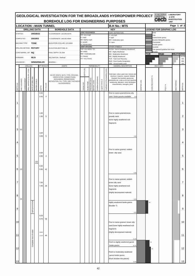
BOREHOLE DATA LEGEND FOR GRAPHIC LOGJOINT SEPARATION Sand
V= very tight Clay
T= tight Garnet biotite gneiss
MO= moderately open Quartzo feldspathic gneiss
O= open Charnockite
Granitic gneiss
Quartzite
SL/CW - Soil & Completely Weathered Calc gneiss/Crystaline lime stone
HW - Highly Weathered Boulder
MW - Moderately Weathered TCR RQDSW - Slightly Weathered SL/CW
TCR - Total Core Recovery HW
RQD - Rock Quality Designation MW
GWL - Ground water Level SW
JOINTS
DA
ILY
AD
VA
NC
E
CA
SIN
G/C
EM
EN
T
FR
OM
TO
P
TO
BO
TT
OM
0.00
0.45 4
1 1
1.50 Fine to coarse grained,loose,
2 1.95 5 2Some highly weathered rock
3 22 33.00
3.45 5
4 4
4.50
5 4.95 4 5
5.6024/08
5.50
6 23 5.95 42 6
7 7.00 77.45 26
8 824
9 9
9.25
9.70 58
10 10
10.80
11 11.25 45 11
12 12
13 13
Ligh
lt gr
eish
bro
wn
Com
plet
e lo
ss o
f wat
er
44
20
32
(Rock brocken into pieces)
13.00
biotite gneiss 11.75
Fresh to moderately weathered
garnet biotite gneiss
(Highly decomposed material)
11.25
Fresh to slightly weathered garnet
Fine to coarse grained, brown silty
sand.Some highly weathered rock
fragments
(Boulder ?)
9.25
(Highly decomposed material)
8.25
Highly weathered biotite gneiss
Fine to coarse grained, reddish
brown silty sand
Some highly weathered rock
fragments
6.30
brown silty sand
Fine to coarse grained, reddish
3.45
gravelly sand
fragments
Fine to coarse grained,loose,silty
sand .Some gravels available 0.45
DE
PT
H (
m)
DR
ILL
WA
TE
R (
CO
LOR
, LO
SS
)
RA
TE
OF
DR
ILLI
NG
WA
TE
R L
EV
ELS
DE
PT
H
N' V
ALU
VE
NO OF JOINTS, SETS, TYPE, SPACING,ORIENTATION, CONNECTIONS,(ROGHNESS, PERSISTANCE,
SEPARATION, FILL TYPE, AND THICKNESSSLICKENSIDED)
DE
PT
H (
M)
PR
ES
SU
RE
(ba
rs)
WA
TE
R L
OS
S
GENERAL DESCRIPTION
GR
AP
HIC
LO
G
RECOVERY
WE
AT
HE
RIN
G
Rock type, colour, grain size, texture andstructure ( massive, cleaved, foliated,
lineated, flow banded, gneissose,porphyritlic,etc: scale as for joint spacing),
weathering, alteration, minor lithologicalcharacteristics, strengths, joints
CO
RE
RE
CO
VE
RY
%
R.Q
.D. %
DE
PT
H (
m)
DRILLING SPT RESULTS PERMEABILITY
(tot
al{li
ters
}/tim
e{m
in}
Luge
on U
nit (
Lu)
Coe
ffici
ent o
f Per
mea
bilit
y (c
m/s
)
LOGGED BY : SRMS/RMLKR BEARING : -
WEATHERING
FOREMAN : WLN INCLINATION : VerticalC= Closely
VC= very closely
OTHER SYMBOLS
VW= very widely> 2m
CORE BARREL, BIT : NQ FINAL DEPTH :30.25mW= widely
MW= moderately wide
DRILLING METHOD : ROTARY ELEVATION (BOTTOM) :mJOINT SPACING
MACHING TYPE : TONE ELEVATION (COLLAR) :123.838mS= smotth
SL=slickensided
VR= very rough
COMPLETED : 2003/9/3 Y-COORDINATE :198,005.489mR: rough
SR: slightly rough
STARTED : 2003/8/22 X-COORDINATE :164,050.587mJOINT ROUGHNESS
GEOLOGICAL INVESTIGATION FOR THE BROADLANDS HYDROPOWER PROJECT
BOREHOLE LOG FOR ENGINEERING PURPOSESPage 1 of 2
DRILLING DATA KEY
LOCATION :-MAIN TUNNEL B.H No.: MT5
LABORATORY & SITEINVESTIGATION UNIT
LABORATORY & SITEINVESTIGATION UNIT
LABORATORY & SITEINVESTIGATION UNIT
LABORATORY & SITEINVESTIGATION UNIT
LABORATORY & SITEINVESTIGATION UNIT
LABORATORY & SITEINVESTIGATION UNIT
LABORATORY & SITEINVESTIGATION UNIT
LABORATORY & SITEINVESTIGATION UNIT
LABORATORY & SITEINVESTIGATION UNIT
42
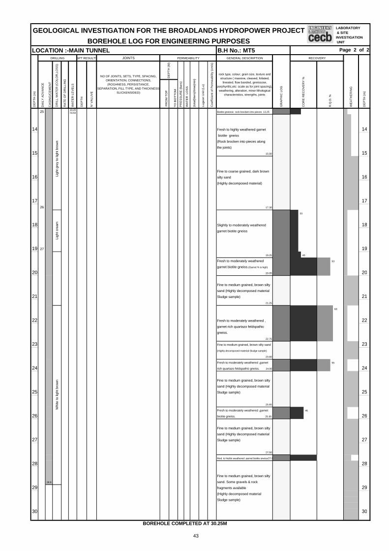
JOINTS
DA
ILY
AD
VA
NC
E
CA
SIN
G/C
EM
EN
T
FR
OM
TO
P
TO
BO
TT
OM
2513.2026/08
14 14
15 15
Fine to coarse grained, dark brown
16 16(Highly decomposed material)
17 1726
18 18
19 27 19
20 20
21 21
22 22
23 23
24 24
25 25
26 26
27 27
28 28
28.9
29 29
30 30
Whi
te to
ligh
t bro
wn
Fine to medium grained, brown silty
sand (Highly decomposed material
Sludge sample)
sand (Highly decomposed material
Sludge sample)
25.65
Ligh
t gre
y to
ligh
t bro
wn
Ligh
t cre
am
GEOLOGICAL INVESTIGATION FOR THE BROADLANDS HYDROPOWER PROJECT
BOREHOLE LOG FOR ENGINEERING PURPOSES
46
55
33
40
53
60
(Highly decomposed material
Sludge sample)
27.50
Mod. to highly weathered ,garnet biotite gneiss/27.65
Fine to medium grained, brown silty
sand. Some gravels & rock
fragments available
Fresh to moderately weathered ,garnet
biotite gneiss. 25.95
Fresh to moderately weathered ,garnet
rich quartazo feldspathic gneiss. 24.00
Fine to medium grained, brown silty
22.75
Fine to medium grained, brown silty sand
(Highly decomposed material-Sludge sample)
23.60
Fresh to moderately weathered ,
garnet rich quartazo feldspathic
gneiss.
sand (Highly decomposed material
Sludge sample)
21.25
garnet biotite gneiss.(Garnet % is high)
20.05
Fine to medium grained, brown silty
19.25
Fresh to moderately weathered
Slightly to moderately weathered
garnet biotite gneiss
17.30
silty sand
biotite gneiss
(Rock brocken into pieces along
the joints)
15.00
Biotite gneissic rock brocken into pieces 13.25
Fresh to highly weathered garnet
DE
PT
H (
m)
DR
ILL
WA
TE
R (
CO
LOR
,LO
SS
)
RA
TE
OF
DR
ILLI
NG
WA
TE
R L
EV
ELS
DE
PT
H
N' V
ALU
VE
NO OF JOINTS, SETS, TYPE, SPACING,ORIENTATION, CONNECTIONS,(ROGHNESS, PERSISTANCE,
SEPARATION, FILL TYPE, AND THICKNESSSLICKENSIDED)
DE
PT
H (
M)
PR
ES
SU
RE
(ba
rs)
WA
TE
R L
OS
S
DE
PT
H (
m)
DRILLING SPT RESULTS PERMEABILITY
(tot
al{li
ters
}/tim
e{m
in}
Luge
on U
nit (
Lu)
Coe
ffici
ent o
f Per
mea
bilit
y (c
m/s
)
GENERAL DESCRIPTION
BOREHOLE COMPLETED AT 30.25M
LOCATION :-MAIN TUNNEL B.H No.: MT5 Page 2 of 2
GR
AP
HIC
LO
G
RECOVERY
WE
AT
HE
RIN
G
rock type, colour, grain size, texture andstructure ( massive, cleaved, foliated,
lineated, flow banded, gneissose,porphyritlic,etc: scale as for joint spacing),
weathering, alteration, minor lithologicalcharacteristics, strengths, joints
CO
RE
RE
CO
VE
RY
%
R.Q
.D. %
LABORATORY & SITEINVESTIGATION UNIT
LABORATORY & SITEINVESTIGATION UNIT
LABORATORY & SITEINVESTIGATION UNIT
LABORATORY & SITEINVESTIGATION UNIT
LABORATORY & SITEINVESTIGATION UNIT
LABORATORY & SITEINVESTIGATION UNIT
43

BOREHOLE DATA LEGEND FOR GRAPHIC LOGJOINT SEPARATION Sand
V= very tight Clay
T= tight Garnet biotite gneiss
MO= moderately open Quartzo feldspathic gneiss
O= open Charnockite
Granitic gneiss
Quartzite
SL/CW - Soil & Completely Weathered Calc gneiss/Crystalline Limestone
HW - Highly Weathered Boulder
MW - Moderately Weathered TCR RQDSW - Slightly Weathered SL/CW
TCR - Total Core Recovery HW
RQD - Rock Quality Designation MW
GWL - Ground water Level SW
JOINTS
DA
ILY
AD
VA
NC
E
CA
SIN
G/C
EM
EN
T
FR
OM
TO
P
TO
BO
TT
OM
0.00
0.45 1
1 1
1.50
2 1.95 57 26
3 33.00
3.45 61
4 7 4
5 5
6 5.75 66.20 16
7 7
8 8
9 99.25
9.70 74
8
10 10
10.65
11 11.10 33 11
12 1212.40
12.60 >50
13 13
sand with weathered feldspar
13.00
Ligh
t bro
wn
Fine to medium grained,brown
silty sand with mica (Sludge sample) 7.00
(Highly weathered rock)
(Sludge sample) 11.30
Fine to coarse grained,brown, silty sand with mica
12.00
Fine to coarse grained,light brown, silty
Fine to coarse grained,reddish brown
clayey silty sand
(Weathered rock fragments) 11.00
Fine to medium grained,brown silty sand
10.20
50Moderate weathered to highly
weathered garnet biotite gneiss 7.20
Fine to medium grained,brown silty sand
with weathered mica (Sludge sample) 7.70
Fine to coarse grained,yellowish brown
silty sand with weathered feldspar and mica
Fine to coarse grained,light brown, silty sand
with weathered feldspar and mica
(Highly decomposed rock)
6.65
80
77
gneiss 5.30
Dar
k B
row
n to
gra
y
3.90
Fresh to highly weathered garnet biotite
gneiss 4.10
Medium to coarse grained brown sand
with mica (Sludge sample)
(Highly decomposed rock) 5.00
Fresh to highly weathered garnet biotite
90
gneiss (may be a boulder)
Fine to coarse grained silty sand with
highly weathered rock fragments
Ligh
t bro
wn
Fine to coarse grained,dark brown , loose
clayey silty sand (Top soil layer) 0.45
Fine to coarse grained,brown, clayey silty
sand with weathered rock fragments 1.00
Fine to coarse grained,brown, dense
silty sand with weathered rock fragments
2.15
Moderate to highly weathered biotite
DE
PT
H (
m)
DE
PT
H (
M)
PR
ES
SU
RE
(ba
rs)
WA
TE
R L
OS
S
(tot
al{li
ters
}/tim
e{m
in}
Luge
on U
nit (
Lu)
Coe
ffici
ent o
f Per
mea
bilit
y (c
m/s
)
GENERAL DESCRIPTION
GR
AP
HIC
LO
G
RECOVERY
WE
AT
HE
RIN
G
Rock type, colour, grain size, texture and structure (massive, cleaved, foliated, lineated, flow banded,
gneissose, porphyritlic,etc: scale as for joint spacing),weathering, alteration, minor lithological characteristics,
strengths, joints
CO
RE
RE
CO
VE
RY
%
R.Q
.D. %
DE
PT
H (
m)
DRILLING SPT RESULTS PERMEABILITY
DR
ILL
WA
TE
R (
CO
LOR
, LO
SS
)
RA
TE
OF
DR
ILLI
NG
WA
TE
R L
EV
ELS
DE
PT
H
N' V
ALU
VE
NO OF JOINTS, SETS, TYPE,SPACING, ORIENTATION,
CONNECTIONS, (ROGHNESS,PERSISTANCE, SEPARATION, FILL
TYPE, AND THICKNESSSLICKENSIDED)
LOGGED BY : SRMS/RMLKR BEARING : -
WEATHERING
FOREMAN : WLN INCLINATION : VerticalC= Closely
VC= very closely
OTHER SYMBOLS
CORE BARREL, BIT : NQ FINAL DEPTH :40.10 mW= widely
MW= moderately wide
DRILLING METHOD : ROTARY ELEVATION (BOTTOM) :mJOINT SPACING
VW= very widely> 2m
MACHING TYPE : TONE ELEVATION (COLLAR) :134.126mS= smotth
SL=slickensided
COMPLETED : 2003/9/16 Y-COORDINATE :197,995.307mR: rough
SR: slightly rough
DRILLING DATA KEY
STARTED : 2003/9/6 X-COORDINATE :164,015.436mJOINT ROUGHNESS
VR= very rough
GEOLOGICAL INVESTIGATION FOR THE BROADLANDS HYDROPOWER PROJECT
BOREHOLE LOG FOR ENGINEERING PURPOSESLOCATION :-MAIN TUNNEL B.H No.: MT 6 Page 1 of 3
LABORATORY & SITEINVESTIGATION UNIT
LABORATORY & SITEINVESTIGATION UNIT
LABORATORY & SITEINVESTIGATION UNIT
LABORATORY & SITEINVESTIGATION UNIT
LABORATORY & SITEINVESTIGATION UNIT
LABORATORY & SITEINVESTIGATION UNIT
44

JOINTS
DA
ILY
AD
VA
NC
E
CA
SIN
G/C
EM
EN
T
FR
OM
TO
P
TO
BO
TT
OM
14 14
15 15
9
16 16
17 17
18 18
19 19
20 20
21 10 21
22 22
23 2312
24 24
25 25
26 26
27 27
28 28
28.4516/9
29 2913
30 30
gravelly sand with highly weathered
rock fragment
(May be weathered rock) 29.20
Gra
y to
bro
wn
Fine to medium grained,dark brown, silty
sand with weathered mica
(Sludge sample) 30.00
28.20
Fine to coarse grained,dark brown silty
Ligh
t to
dark
bro
wn
25.55
Fine to coarse grained,dark brown, silty
gravelly sand with weathered mica
(Sludge sample)
biotite gneiss
gneiss
24.25
Moderate to highly weathered garnet 29
quartzo feldspathic gneiss 23.35
Fresh to moderately weathered biotite 27
64
with weathered mica(Sludge sample) 23.00
Fresh to moderately weathered garnetiferrous 60Whi
tish
brow
n(at
22.
65m
Com
plet
e w
ater
loss
)
22.00
Yellowish brown silty sand(Sludge sample) 22.30
Fresh to moderately weathered garnet biotite gneiss22.50
Fine to coarsegrained,brown silty sand
Ligh
t cre
amy
red
Fine to coarse grained,light brown, silty
sand with weathered feldspar and mica
(Sludge sample)
18.30
Fine to coarse grained,dark brown, silty
sand with weathered feldspar and mica
(Sludge sample)
sand with mica (Sludge sample)
17.30
Fine to coarse grained,dark brown, silty
sand with mica (Sludge sample) 15.80
Fine brown silt (Sludge sample) 16.00
Fine to coarse grained,dark brown, silty
40
55
Bro
wn
to L
ight
gra
y
Fine to coarse grained,light brown, silty sand
with weathered feldspar 13.50
Highly weathered biotite gneiss
14.00
Fine to medium grained,brown, silty
sand with weathered mica (Sludge sample)
(May be decomposed rock)
15.00
Highly weathered biotite gneiss 15.40
DE
PT
H (
m)
DE
PT
H (
M)
PR
ES
SU
RE
(ba
rs)
WA
TE
R L
OS
S
(tot
al{li
ters
}/tim
e{m
in}
Luge
on U
nit (
Lu)
Coe
ffici
ent o
f Per
mea
bilit
y (c
m/s
)
GENERAL DESCRIPTION
GR
AP
HIC
LO
G
RECOVERY
WE
AT
HE
RIN
G
rock type, colour, grain size, texture and structure (massive, cleaved, foliated, lineated, flow banded,
gneissose, porphyritlic,etc: scale as for joint spacing),weathering, alteration, minor lithological characteristics,
strengths, joints
CO
RE
RE
CO
VE
RY
%
R.Q
.D. %
DE
PT
H (
m)
DRILLING SPT RESULTS PERMEABILITY
DR
ILL
WA
TE
R (
CO
LOR
,LO
SS
)
RA
TE
OF
DR
ILLI
NG
WA
TE
R L
EV
ELS
DE
PT
H
N' V
ALU
VE
NO OF JOINTS, SETS, TYPE,SPACING, ORIENTATION,
CONNECTIONS, (ROGHNESS,PERSISTANCE, SEPARATION, FILL
TYPE, AND THICKNESSSLICKENSIDED)
BOREHOLE LOG FOR ENGINEERING PURPOSESLOCATION :- MAIN TUNNEL B.H No.: MT 6 Page 2 of 3
GEOLOGICAL INVESTIGATION FOR THE BROADLANDS HYDROPOWER PROJECT LABORATORY & SITEINVESTIGATION UNIT
LABORATORY & SITEINVESTIGATION UNIT
LABORATORY & SITEINVESTIGATION UNIT
45

JOINTS
DA
ILY
AD
VA
NC
E
CA
SIN
G/C
EM
EN
T
FR
OM
TO
P
TO
BO
TT
OM
31 31
32 32
33 33
34 34
14
35 35
36 36
37 37
38 38.00 38
39 39
Joint at 40.10(sub horizontal)
40 joint surface slightly weathered 4015 into rock
41 41
42 42
43 43
44 44
45 45
46 46
47 47
40.10
BOREHOLE COMPLETED AT 40.10m
93
85
Ligh
t gra
y(38
.95m
com
plet
e w
ater
loss
)
Fresh garnet biotite gneiss 93
(High % of Quartz)
Ligh
t gra
y to
dar
k br
own
37.80
Slight to highly weathered garnet
biotite gneiss 38.00
(Sludge sample)
31.20
Fine to coarse grained,dark brown silty
Ligh
t bro
wn
to d
ark
brow
n
gravelly sand
32.70
Fine to coarse grained,dark brown silty
sand with weathered mica
Fine to coarse grained,dark brown, silty
gravelly sand with rock fragments
DE
PT
H (
m)
DE
PT
H (
M)
PR
ES
SU
RE
(ba
rs)
WA
TE
R L
OS
S
(tot
al{li
ters
}/tim
e{m
in}
Luge
on U
nit (
Lu)
Coe
ffici
ent o
f Per
mea
bilit
y (c
m/s
)
GENERAL DESCRIPTION
GR
AP
HIC
LO
G
RECOVERY
WE
AT
HE
RIN
G
rock type, colour, grain size, texture and structure (massive, cleaved, foliated, lineated, flow banded,
gneissose, porphyritlic,etc: scale as for joint spacing),weathering, alteration, minor lithological characteristics,
strengths, joints
CO
RE
RE
CO
VE
RY
%
R.Q
.D. %
DE
PT
H (
m)
DRILLING SPT RESULTS PERMEABILITY
DR
ILL
WA
TE
R (
CO
LOR
,LO
SS
)
RA
TE
OF
DR
ILLI
NG
WA
TE
R L
EV
ELS
DE
PT
H
N' V
ALU
VE
NO OF JOINTS, SETS, TYPE,SPACING, ORIENTATION,
CONNECTIONS, (ROGHNESS,PERSISTANCE, SEPARATION, FILL
TYPE, AND THICKNESSSLICKENSIDED)
GEOLOGICAL INVESTIGATION FOR THE BROADLANDS HYDROPOWER PROJECT
BOREHOLE LOG FOR ENGINEERING PURPOSESLOCATION :- MAIN TUNNEL B.H No.: MT 6 Page 3 of 3
LABORATORY & SITEINVESTIGATION UNIT
LABORATORY & SITEINVESTIGATION UNIT
LABORATORY & SITEINVESTIGATION UNIT
46

BOREHOLE DATA LEGEND FOR GRAPHIC LOGJOINT SEPARATION Sand
V= very tight Clay
T= tight Garnet biotite gneiss
MO= moderately open Quartzo feldspathic gneiss
O= open Charnockite
Granitic gneiss
Quartzite
SL/CW - Soil & Completely Weathered Calc gneiss/Crystalline Lime Stone
HW - Highly Weathered Boulder
MW - Moderately Weathered TCR RQDSW - Slightly Weathered SL/CW
TCR - Total Core Recovery HW
RQD - Rock Quality Designation MW
GWL - Ground water Level SW
JOINTS
DA
ILY
AD
VA
NC
E
CA
SIN
G/C
EM
EN
T
FR
OM
TO
P
TO
BO
TT
OM
0.00
0.45 6
1 1
1.55
2 2.00 8 2
3 3.00 33.45 16
4 4
4.55
5 17 5.00 12 5
6 6.00 66.45 7
7 7
7.557.8918/9 7.68 >50
8 8
9 9.0419/9 9.00 9
9.27 >50
10 10
10.55
11.00 42
11 10.9221/9 11
12 12.00 1218 12.38 >50
13 1313.00
Bro
wn
Fine to coarse grained,reddish brown,loose
clayey,silty sand(Top soil layer) 0.45
Fine to coarse grained,reddish brown,
silty sand (More % of coarse grains available)
Quartz sand
11.00
Fine to coarse grained,reddish brown,dense
7.68
Fine to medium grained,reddish brown
silty sand
(Some weathered micas available)
silty,sand
(Some gravels available)
3.00
Fine to coarse grained,red to pink, clayey
DE
PT
H (
m)
DE
PT
H (
M)
PR
ES
SU
RE
(ba
rs)
WA
TE
R L
OS
S
(tot
al{li
ters
}/tim
e{m
in}
Luge
on U
nit (
Lu)
Coe
ffici
ent o
f Per
mea
bilit
y (c
m/s
)
GENERAL DESCRIPTION
GR
AP
HIC
LO
G
RECOVERY
WE
AT
HE
RIN
G
Rock type, colour, grain size, texture and structure (massive, cleaved, foliated, lineated, flow banded,
gneissose, porphyritlic,etc: scale as for joint spacing),weathering, alteration, minor lithological characteristics,
strengths, joints
CO
RE
RE
CO
VE
RY
%
R.Q
.D. %
DE
PT
H (
m)
DRILLING SPT RESULTS PERMEABILITY
DR
ILL
WA
TE
R (
CO
LOR
, LO
SS
)
RA
TE
OF
DR
ILLI
NG
WA
TE
R L
EV
ELS
DE
PT
H
N' V
ALU
VE
NO OF JOINTS, SETS, TYPE, SPACING,ORIENTATION, CONNECTIONS,(ROGHNESS, PERSISTANCE,
SEPARATION, FILL TYPE, ANDTHICKNESS SLICKENSIDED)
LOGGED BY : SRMS/RMLKR BEARING : -
WEATHERING
FOREMAN : MRAMHP INCLINATION : VerticalC= Closely
VC= very closely
OTHER SYMBOLS
CORE BARREL, BIT : NX FINAL DEPTH :60.00mW= widely
MW= moderately wide
DRILLING METHOD : ROTARY ELEVATION (BOTTOM) :mJOINT SPACING
VW= very widely> 2m
MACHING TYPE : TONE ELEVATION (COLLAR) :124.040mS= smotth
SL=slickensided
COMPLETED : 2003/10/6 Y-COORDINATE :198,111.429mR: rough
SR: slightly rough
DRILLING DATA KEY
STARTED : 2003/9/17 X-COORDINATE :161,591.171mJOINT ROUGHNESS
VR= very rough
GEOLOGICAL INVESTIGATION FOR THE BROADLANDS HYDROPOWER PROJECT
BOREHOLE LOG FOR ENGINEERING PURPOSESLOCATION :- SURGE TANK B.H No.: MT 7 Page 1 of 4
LABORATORY & SITEINVESTIGATION UNIT
LABORATORY & SITEINVESTIGATION UNIT
LABORATORY & SITEINVESTIGATION UNIT
LABORATORY & SITEINVESTIGATION UNIT
LABORATORY & SITEINVESTIGATION UNIT
LABORATORY & SITEINVESTIGATION UNIT
LABORATORY & SITEINVESTIGATION UNIT
LABORATORY & SITEINVESTIGATION UNIT
LABORATORY & SITEINVESTIGATION UNIT
47

JOINTS
DA
ILY
AD
VA
NC
E
CA
SIN
G/C
EM
EN
T
FR
OM
TO
P
TO
BO
TT
OM
13.00
13.45 16
14 14
15 15.00 1515.45 14
16 16
16.55
17.00 18
17 17
18 1818.00
18.24 >50
19 18.9522/9 19
19.55
19.60 >50
20 19 20
20.48
21 21
22 22
23 23
24 24
25 21 (Core loss due to weathered zone 25from 25.0 to 25.45m)
Joint at 25.45(irregular) highly
weathered in to rock
26 Joint at 25.85m(300) joint surface 1 - 26.00 26slightly weathered into rock) 4 0.05
7 0.25
25.50 29.00 10 0.63 0.1 3x10⁻⁶
27 7 0.30 27(Joint set has developed from 27.50 4 0.14
to 28.33m along the foliation planes 1 0.03
foliation planes, joint intensity 5/m)
28 28
29 22 29
30 30
100 100
(In some places pegmatitic feature appeared)
Ligh
t gre
y
28.33
Fresh biotite gneiss
(Quartz % is high)
30.00
27.50
Slightly weathered biotite gneiss 90 50
80 60
Slightly weathered biotite gneiss 25
(Some garnets available)
58 44
gneiss (Pegmatitic feature appeared)
(Core loss due to weathered zone)
gneiss
25.00
Slightly to moderately weathered biotite
24.00
Moderate to highly weathered biotite 20
23.00
Slightly to moderately weathered biotite 22
gneiss
35
18
Ligh
t bro
wn
to li
ght g
rey
20.48
Moderate to highly weathered biotite
gneiss
Fine to medium grained,light brown
silty sand
(Some weathered micas available)
(May be highly decomposed rock)
17.50
Bro
wn
Fine to medium grained,brown
silty sand
(Some weathered micas available)
DE
PT
H (
m)
DE
PT
H (
M)
PR
ES
SU
RE
(ba
rs)
WA
TE
R L
OS
S
(tot
al{li
ters
}/tim
e{m
in}
Luge
on U
nit (
Lu)
Coe
ffici
ent o
f Per
mea
bilit
y (c
m/s
)
GENERAL DESCRIPTION
GR
AP
HIC
LO
G
RECOVERY
WE
AT
HE
RIN
G
rock type, colour, grain size, texture and structure (massive, cleaved, foliated, lineated, flow banded,
gneissose, porphyritlic,etc: scale as for joint spacing),weathering, alteration, minor lithological characteristics,
strengths, joints
CO
RE
RE
CO
VE
RY
%
R.Q
.D. %
DE
PT
H (
m)
DRILLING SPT RESULTS PERMEABILITYD
RIL
L W
AT
ER
(C
OLO
R,L
OS
S)
RA
TE
OF
DR
ILLI
NG
WA
TE
R L
EV
ELS
DE
PT
H
N' V
ALU
VE
NO OF JOINTS, SETS, TYPE, SPACING,ORIENTATION, CONNECTIONS,(ROGHNESS, PERSISTANCE,
SEPARATION, FILL TYPE, ANDTHICKNESS SLICKENSIDED)
BOREHOLE LOG FOR ENGINEERING PURPOSESLOCATION :- SURGE TANK B.H No.: MT 7 Page 2 of 4
GEOLOGICAL INVESTIGATION FOR THE BROADLANDS HYDROPOWER PROJECT LABORATORY & SITEINVESTIGATION UNIT
LABORATORY & SITEINVESTIGATION UNIT
LABORATORY & SITEINVESTIGATION UNIT
48

JOINTS
DA
ILY
AD
VA
NC
E
CA
SIN
G/C
EM
EN
T
FR
OM
TO
P
TO
BO
TT
OM
1 -Joint at 31.48m(250) (tight joint) 4 0.08
31 Joint at 31.63m(350) (tight joint- 7 1.30 31surface filled with thin film of white material) 29.00 34.36 10 1.56 0.20 3x10⁻⁶
23 Joints at 32.05 & 32.25m(150) 7 1.38
Joint at 32.65(500) 4 0.42
32 Joint at 32.90(200)( tight joints- 1 0.02 32surfaces slightly weathered into rock)
Joint at 32.94(450) (tight joint ,surface
filled with white secondary material)
33 Joint zone from 32.97 to 33.10m 33(Joint surfaces slightly weathered into rock)
Joint from 33.25 to 33.35m(550)
Suface filled with grey thin film
34 Joint at 33.50(subvertical) tight joint (Small amount of garnet avilable section from 3424 surface slightly weathered into rock
Joint at 34.00(400) tight joint 1 -Foliation joint at 34.36(300) 4 0.03
35 Highly jointed zone(subvertical & 7 0.16 35subhorizontal) from 34.36 to 36.40m 34.25 39.00 10 0.25 0.0 6x10⁻⁷
(joint surfaces filled with black material, 7 0.17
Rock has broken into pieces due to joints) 4 0.05
36 Joint at 34.90(350) (surface filled with 1 - 36thick white material)
37 25 37
38 38
39 Joint from 39.22 to 39.66m(subvertical) 39surface filled with white secondary material 1 -
4 0.20
7 0.10
40 27 39.00 44.00 10 0.15 0.0 3x10⁻⁷ 40Joint at 40.98m(300) (tight folition joint) 7 0.12
4 0.40
1 -41 41
Joint from 42.22 to 42.41m(vertical)
42 28 (surface filled with white secondary material) 42Joint at 42.73m(300) (tight joint-
surface filled with grey secondary material)
43 43Joint at 43.45m(300)
Joint at 43.75m(450)
(surfaces filled with black secondary material)
44 29 Joint from 44.0 to44.20m(subvertical) 44Joint at 44.80m(300)
(surface filled with dark grey material)
45 1 - 454 0.04
7 0.15
43.90 49.00 10 0.20 0.0 4x10⁻⁷
46 7 0.16 464 0.04
1 -
47 4747.00
46.00
Fresh biotite gneiss
100
44.20
Fresh biotite gneiss
(Quartz % is high)
Fresh biotite gneiss 90
(Small amount of garnet available)
100
43.00
75
40.00
Fresh garnet biotite gneiss 98
(Quartz % is high)
64
(Small amount of garnet avilable)
Fresh biotite gneiss 100 100
(Quartz % is high)
36.40
(Biotite % is high)
(Small biotite bands available)
70
(Quartz & garnet rich layer from 33.40 to 33.47m)
34.00 to 34.36m) 34.36
Fresh biotite gneiss 83 39
33.00
Fresh biotite gneiss 90
82
Fresh garnet biotite gneiss 95
rock type, colour, grain size, texture and structure (massive, cleaved, foliated, lineated, flow banded,
gneissose, porphyritlic,etc: scale as for joint spacing),weathering, alteration, minor lithological characteristics,
strengths, joints
CO
RE
RE
CO
VE
RY
%
R.Q
.D. %
Ligh
t gre
y
Fresh biotite gneiss 100 100
(Quartz % is high)
31.00
WA
TE
R L
OS
S
(tot
al{li
ters
}/tim
e{m
in}
Luge
on U
nit (
Lu)
Coe
ffici
ent o
f Per
mea
bilit
y (c
m/s
)
WE
AT
HE
RIN
G
DE
PT
H (
m)
DR
ILL
WA
TE
R (
CO
LOR
,LO
SS
)
RA
TE
OF
DR
ILLI
NG
WA
TE
R L
EV
ELS
DE
PT
H
N' V
ALU
VE
NO OF JOINTS, SETS, TYPE, SPACING,ORIENTATION, CONNECTIONS,(ROGHNESS, PERSISTANCE,
SEPARATION, FILL TYPE, ANDTHICKNESS SLICKENSIDED)
DE
PT
H (
M)
PR
ES
SU
RE
(ba
rs)
LOCATION :- SURGE TANK B.H No.: MT 7 Page 3 of 4
DE
PT
H (
m)
DRILLING SPT RESULTS PERMEABILITY GENERAL DESCRIPTION
GR
AP
HIC
LO
G
RECOVERY
GEOLOGICAL INVESTIGATION FOR THE BROADLANDS HYDROPOWER PROJECT
BOREHOLE LOG FOR ENGINEERING PURPOSES
LABORATORY & SITEINVESTIGATION UNIT
LABORATORY & SITEINVESTIGATION UNIT
LABORATORY & SITEINVESTIGATION UNIT
49

JOINTS
DA
ILY
AD
VA
NC
E
CA
SIN
G/C
EM
EN
T
FR
OM
TO
P
TO
BO
TT
OM
48 4830
49 Joint from 49.30 to 49.55m(subvertical-tight 49joint surface filled with grey material)
Joint at 49.78m(300)
(surface filled with dark grey material)
50 Joints from 49.90 to 50.15 & 5050.20 to 50.47m(800)
(surface filled with dark grey material) 1 -Joint at 50.53m(subhorizontal-tight joint) 4 0.02
51 7 0.10 511 49.00 54.00 10 0.14 0.0 3x10⁻⁷
7 0.10
4 0.03
52 1 - 52
Joints from 52.45 to 52.62 &
52.72 to 52.80m(800)( tight joints)
53 2 53Joint at 53.52m(300)
(Trimolite available along the joint)
54 541 -4 0.02
7 0.08
55 54.00 59.00 10 0.13 0.0 3x10⁻⁷ 557 0.09
4 0.04
1 -56 4 56
57 57Joint at 57.61(300) (fresh,tight joint)
1 -58 4 - 58
7 0.05
57.50 60.00 10 0.08 0.0 3x10⁻⁷
Joint at 59.53(400)(fresh,tight joint- 7 0.06
59 5 surface filled with grey secondary material) 4 0.02 59Joint from 59.88 to 60.00m(subvertical) 1 -(surface filled with light grey material)
Joint at 60.00m(200)(tight & fresh joint)
60 6 60
61 61
62 62
63 63
64 64
100
74
100
50.47
Fresh garnet biotite gneiss
(Quartz % is high)
52
Fresh biotite gneiss
Ligh
t gre
y
Fresh garnet biotite gneiss
49.40
DE
PT
H (
m)
DE
PT
H (
M)
PR
ES
SU
RE
(ba
rs)
WA
TE
R L
OS
S
(tot
al{li
ters
}/tim
e{m
in}
Luge
on U
nit (
Lu)
Coe
ffici
ent o
f Per
mea
bilit
y (c
m/s
)
GENERAL DESCRIPTION
GR
AP
HIC
LO
G
RECOVERY
WE
AT
HE
RIN
G
rock type, colour, grain size, texture and structure (massive, cleaved, foliated, lineated, flow banded,
gneissose, porphyritlic,etc: scale as for joint spacing),weathering, alteration, minor lithological characteristics,
strengths, joints
CO
RE
RE
CO
VE
RY
%
R.Q
.D. %
DE
PT
H (
m)
DRILLING SPT RESULTS PERMEABILITYD
RIL
L W
AT
ER
(C
OLO
R,L
OS
S)
RA
TE
OF
DR
ILLI
NG
WA
TE
R L
EV
ELS
DE
PT
H
N' V
ALU
VE
NO OF JOINTS, SETS, TYPE, SPACING,ORIENTATION, CONNECTIONS,(ROGHNESS, PERSISTANCE,
SEPARATION, FILL TYPE, ANDTHICKNESS SLICKENSIDED)
GEOLOGICAL INVESTIGATION FOR THE BROADLANDS HYDROPOWER PROJECTBOREHOLE LOG FOR ENGINEERING PURPOSES
LOCATION :- SURGE TANK B.H No.: MT 7 Page 4 of 4
65
60.00
Bore hole completed at 60.00m
LABORATORY & SITEINVESTIGATION UNIT
LABORATORY & SITEINVESTIGATION UNIT
LABORATORY & SITEINVESTIGATION UNIT
50

BOREHOLE DATA LEGEND FOR GRAPHIC LOGJOINT SEPARATION Sand
V= very tight Clay
T= tight Garnet biotite gneiss
MO= moderately open Quartzo feldspathic gneiss
O= open Charnockite
Granitic gneis
Quartzite
SL/CW - Soil & Completely Weathered Calc gneiss/Crystaline lime stone
HW - Highly Weathered Boulder
MW - Moderately Weathered TCR RQDSW - Slightly Weathered SL/CW
TCR - Total Core Recovery HW
RQD - Rock Quality Designation MW
GWL - Ground water Level SW
JOINTS
DA
ILY
AD
VA
NC
E
CA
SIN
G/C
EM
EN
T
FR
OM
TO
P
TO
BO
TT
OM
0.00
0.45 5
1 1
121.4512/8
2 2
3 2.8819/8 3
4 4
5 5
6 6
7 7
7.5313/8
8 8
9 9
13
10 10
11 11
12 12
12.847/9
13 13
GEOLOGICAL INVESTIGATION FOR THE BROADLANDS HYDROPOWER PROJECT
BOREHOLE LOG FOR ENGINEERING PURPOSESLOCATION :- MAIN TUNNEL B.H No.: MT 8 Page 1 of 5
DRILLING DATA KEY
STARTED : 2003/12/8 X-COORDINATE :161,984.829mJOINT ROUGHNESS
VR= very rough
COMPLETED : 2003/9/9 Y-COORDINATE :197,955.406mR: rough
SR: slightly rough
JOINT SPACING
MACHING TYPE : TONE ELEVATION (COLLAR) :154.587mS= smotth
SL=slickensided
OTHER SYMBOLS
VW= very widely> 2m
CORE BARREL, BIT : NX FINAL DEPTH :80.06mW= widely
MW= moderately wide
DRILLING METHOD : ROTARY ELEVATION (BOTTOM) :m
WEATHERING
FOREMAN : MRAMHP INCLINATION : VerticalC= Closely
VC= very closely
LOGGED BY : SRMS/RMLKR BEARING : -
DE
PT
H (
m)
DRILLING SPT RESULTS PERMEABILITY
(tot
al{li
ters
}/tim
e{m
in}
Luge
on U
nit (
Lu)
Coe
ffici
ent o
f Per
mea
bilit
y (c
m/s
)
GENERAL DESCRIPTION
GR
AP
HIC
LO
G
RECOVERY
WE
AT
HE
RIN
G
Rock type, colour, grain size, texture andstructure ( massive, cleaved, foliated,
lineated, flow banded, gneissose,porphyritlic,etc: scale as for joint spacing),
weathering, alteration, minor lithologicalcharacteristics, strengths, joints
CO
RE
RE
CO
VE
RY
%
R.Q
.D. %
DE
PT
H (
m)
DR
ILL
WA
TE
R (
CO
LOR
, LO
SS
)
RA
TE
OF
DR
ILLI
NG
WA
TE
R L
EV
ELS
DE
PT
H
N' V
ALU
VE
NO OF JOINTS, SETS, TYPE, SPACING,ORIENTATION, CONNECTIONS,(ROGHNESS, PERSISTANCE,
SEPARATION, FILL TYPE, AND THICKNESSSLICKENSIDED)
DE
PT
H (
M)
PR
ES
SU
RE
(ba
rs)
WA
TE
R L
OS
S
Bro
wn
Fine to medium grained,dark brown,
clayey silty sand (Top soil layer) 0.55
Slightly weathered garnet hornblend
2.00to
2.24>50
Fine to medium grained, brown,
dense,silty sand
(Some weathered micas available)
2.24
40
gneiss
(May be a boulder)
1.60
Fine to medium grained, light brown,
silty sand (Sludge sample)
(Some weathered micas available)
9.50
Fine to coarse grained, light grey,
silty sand (Sludge sample)
(Some weathered micas and
feldspars available)
(May be highly decomposed rock)
12.18
Fresh slightly weathered, biotite 37 21
gneiss (Small amount of garnets
available) 13.00
LABORATORY & SITEINVESTIGATION UNIT
LABORATORY & SITEINVESTIGATION UNIT
LABORATORY & SITEINVESTIGATION UNIT
LABORATORY & SITEINVESTIGATION UNIT
LABORATORY & SITEINVESTIGATION UNIT
LABORATORY & SITEINVESTIGATION UNIT
LABORATORY & SITEINVESTIGATION UNIT
LABORATORY & SITEINVESTIGATION UNIT
LABORATORY & SITEINVESTIGATION UNIT
51

JOINTS
DA
ILY
AD
VA
NC
E
CA
SIN
G/C
EM
EN
T
FR
OM
TO
P
TO
BO
TT
OM
14 14
15 15
Joint at 16.18m (sub horizontal) 1 -
16 16.0 (irregular, joint surface weathered 4 0.43 1615 into rock) 7 0.85
Joint at 17.78m (sub horizontal) 16.50 20.00 10 1.28 0.3 4x10⁻⁶
(irregular joint) 7 0.86
17 Joint at 17.28m (100) 4 0.45 17( joint surface slightly weathered 1 -
into rock)
Joint from 17.52 to 17.56m
18 (Weathered zone) 18
Joint at 18.56m(sub vertical)
( joint surface weathered into rock)
19 19Joint at 19.06m (subhorizontal)
(tight joint,surface filled thin film of
reddish brown material)
20 19 20(Highly jionted zone from 20.0 to 21.0m
core loss due to joints)
21 1 - 214 0.30
Joint at 21.07(sub horizontal) 7 0.87
(irregular, joint surface slightly weathered 19.50 24.55 10 1.85 0.3 5x10⁻⁶
22 into rock) 7 1.37 224 0.82
1 0.15
23 23
24 24
20
25 Joint at 25.26m (350) 25 (joint surface filled thin film of grey
secondary material)
26 261 -
4 -
7 0.07
27 24.60 29.00 10 0.12 0.0 3x10⁻⁷ 277 0.08
4 0.03
1 -
28 22 28
29 29
30 23 30
GEOLOGICAL INVESTIGATION FOR THE BROADLANDS HYDROPOWER PROJECT
BOREHOLE LOG FOR ENGINEERING PURPOSESLOCATION :- MAIN TUNNEL B.H No.: MT 8 Page 2 of 5
DE
PT
H (
m)
DRILLING SPT RESULTS PERMEABILITY
(tot
al{li
ters
}/tim
e{m
in}
Luge
on U
nit (
Lu)
Coe
ffici
ent o
f Per
mea
bilit
y (c
m/s
)
GENERAL DESCRIPTION
GR
AP
HIC
LO
G
RECOVERY
WE
AT
HE
RIN
G
rock type, colour, grain size, texture andstructure ( massive, cleaved, foliated,
lineated, flow banded, gneissose,porphyritlic,etc: scale as for joint spacing),
weathering, alteration, minor lithologicalcharacteristics, strengths, joints
CO
RE
RE
CO
VE
RY
%
R.Q
.D. %
DE
PT
H (
m)
DR
ILL
WA
TE
R (
CO
LOR
,LO
SS
)
RA
TE
OF
DR
ILLI
NG
WA
TE
R L
EV
ELS
DE
PT
H
N' V
ALU
VE
NO OF JOINTS, SETS, TYPE, SPACING,ORIENTATION, CONNECTIONS,(ROGHNESS, PERSISTANCE,
SEPARATION, FILL TYPE, AND THICKNESSSLICKENSIDED)
DE
PT
H (
M)
PR
ES
SU
RE
(ba
rs)
WA
TE
R L
OS
S
Bro
wn
Fresh slightly weathered, biotite 24 16
gneiss (Small amount of garnets
avilable)
14.38
Fine to coarse grained, light grey,
silty sand (Sludge sample)
(Some weathered micas and
feldspars available)
(May be highly decomposed rock)
16.00
Ligh
t gre
y
Fresh garnet biotite gneiss 95
Fresh biotite gneiss 97
19.00
Fresh Quartz rich garnet biotite
90
17.00
85
(Small amount of garnets avilable)
71 50
98 86
gneiss
20.00
Fresh to moderately weathered 63 30
Quartz richgarnet biotite
21.00
Gre
y
Fresh Quartz rich garnet biotite
(Quartz rich bands
from 22.67 to 22.72m
from 26.90 to 27.10m
from 29.00 to 29.20m)
100 90
gneiss
100
from 23.83 to 24.24m
from 24.36 to 25.00m
from 25.35 to 25.55m
Ligh
t gre
y
30.00
LABORATORY & SITEINVESTIGATION UNIT
LABORATORY & SITEINVESTIGATION UNIT
LABORATORY & SITEINVESTIGATION UNIT
52

JOINTS
DA
ILY
AD
VA
NC
E
CA
SIN
G/C
EM
EN
T
FR
OM
TO
P
TO
BO
TT
OM
1 -4 -
31 7 0.04 3129.00 34.00 10 0.06 0.0 2x10⁻⁷
7 0.05
4 -32 1 - 32
33 33
34 26 34
35 35
1 -
36 4 0.03 367 0.05
34.00 39.00 10 0.12 0.0 3x10⁻⁷
7 0.06
37 27 Two parellel joints at 37.36 & 37.93m(450) 4 0.05 37(joint surfaces filled with thick film of 1 0.02
white secondary material)
Joint at 37.75m (500)
38 ( joint surface filled thin film of black 38secondary material)
Joint at 37.53m (450) tight joint
39 28 39Joint at 39.75m (450)
( joint surface filled by thin grey film)
Joint at 40.30m (500)
40 ( joint surface filled by thin black material ) 40Joint at 40.80m (500) (slicken sided joint)
(joint surfaces filled with thin film of
black secondary material)
41 411 -4 0.06
7 0.09
42 39.15 44.63 10 0.15 0.0 4x10⁻⁷ 427 0.09
4 0.05
1 -43 43
44 44
30
1 -
45 4 0.02 45Joint from 45.70 to 46.30m(vertical) 7 0.06
44.50 49.00 10 0.17 0.0 5x10⁻⁷
7 0.09 46.95m)
46 4 0.04 461 -
Joint at 47.07m (300)
(joint surfaces filled with thin film of
47 grey secondary material) 47
GEOLOGICAL INVESTIGATION FOR THE BROADLANDS HYDROPOWER PROJECT
BOREHOLE LOG FOR ENGINEERING PURPOSESLOCATION :- MAIN TUNNEL B.H No.: MT 8 Page 3 of 5
DE
PT
H (
m)
DRILLING SPT RESULTS PERMEABILITY
(tot
al{li
ters
}/tim
e{m
in}
Luge
on U
nit (
Lu)
Coe
ffici
ent o
f Per
mea
bilit
y (c
m/s
)
GENERAL DESCRIPTION
GR
AP
HIC
LO
G
RECOVERY
WE
AT
HE
RIN
G
rock type, colour, grain size, texture andstructure ( massive, cleaved, foliated,
lineated, flow banded, gneissose,porphyritlic,etc: scale as for joint spacing),
weathering, alteration, minor lithologicalcharacteristics, strengths, joints
CO
RE
RE
CO
VE
RY
%
R.Q
.D. %
DE
PT
H (
m)
DR
ILL
WA
TE
R (
CO
LOR
,LO
SS
)
RA
TE
OF
DR
ILLI
NG
WA
TE
R L
EV
ELS
DE
PT
H
N' V
ALU
VE
NO OF JOINTS, SETS, TYPE, SPACING,ORIENTATION, CONNECTIONS,(ROGHNESS, PERSISTANCE,
SEPARATION, FILL TYPE, AND THICKNESSSLICKENSIDED)
DE
PT
H (
M)
PR
ES
SU
RE
(ba
rs)
WA
TE
R L
OS
S
Ligh
t gre
y
Fresh Quartz rich garnet biotite 100 100
gneiss
(Quartz rich bands
from 31.40 to 31.52m
from 34.92 to 35.04m)
(Pegmatitic features appaered from
36.75 to 37.15m)
37.00
Fresh biotite gneiss 91
(Pegmatitic features appaered from
38.16 to 38.86m)
39.00
Fresh biotite gneiss 68
(Biotite % is high)
100
(Biotite rich layer from 45.70 to
70
47.00
LABORATORY & SITEINVESTIGATION UNIT
LABORATORY & SITEINVESTIGATION UNIT
LABORATORY & SITEINVESTIGATION UNIT
53

JOINTS
DA
ILY
AD
VA
NC
E
CA
SIN
G/C
EM
EN
T
FR
OM
TO
P
TO
BO
TT
OM
48 48Joint at 48.58m (irregular)
(joint surface filled with thin film of 50.30m)
grey secondary material)
49 31 Joint at 50.70m (irregular) 49(joint surface filled with thin film of
black secondary material)
Joint at 51.18m (600) tight joint
50 Joint at 51.40m (300) tight joint 50(joint surface filled with thin film of 1 -black secondary material) 4 -
1 7 0.07
51 49.00 54.00 10 0.12 0.0 3x10⁻⁷ 517 0.08
4 0.02
1 -52 52
Joint at 52.26 & 53.97m (300) tight joint 53.28m)
(joint surfaces filled with thin film of
grey secondary material)
53 53
54 54
55 55
56 1 - 564 -7 0.08
54.00 59.00 10 0.14 0.0 4x10⁻⁷
57 3 7 0.08 574 0.03
1 -
58 58
59 59
Joint at 59.30m (350) tight joint
joint surface filled with thin film of
60 black secondary material 60Joint at 60.95m (400) tight fresh joint
61 611 -4 0.03
7 0.09
62 Joint at 62.05m (700) tight joint 59.00 64.00 10 0.18 0.0 5x10⁻⁷ 62joint surface filled with thin film of 7 0.10
dark grey secondary material 4 0.04
Joint from 62.30 to 62.47 (600) tight joint 1 -63 joint surface filled with thin film of 63
black secondary material
4
64 64
GEOLOGICAL INVESTIGATION FOR THE BROADLANDS HYDROPOWER PROJECT
BOREHOLE LOG FOR ENGINEERING PURPOSESLOCATION :- MAIN TUNNEL B.H No.: MT 8 Page 4 of 5
DE
PT
H (
m)
DRILLING SPT RESULTS PERMEABILITY
(tot
al{li
ters
}/tim
e{m
in}
Luge
on U
nit (
Lu)
Coe
ffici
ent o
f Per
mea
bilit
y (c
m/s
) GENERAL DESCRIPTION
GR
AP
HIC
LO
G
RECOVERY
WE
AT
HE
RIN
G
rock type, colour, grain size, texture andstructure ( massive, cleaved, foliated,
lineated, flow banded, gneissose,porphyritlic,etc: scale as for joint spacing),
weathering, alteration, minor lithologicalcharacteristics, strengths, joints
CO
RE
RE
CO
VE
RY
%
R.Q
.D. %
DE
PT
H (
m)
DR
ILL
WA
TE
R (
CO
LOR
,LO
SS
)
RA
TE
OF
DR
ILLI
NG
WA
TE
R L
EV
ELS
DE
PT
H
N' V
ALU
VE
NO OF JOINTS, SETS, TYPE, SPACING,ORIENTATION, CONNECTIONS,(ROGHNESS, PERSISTANCE,
SEPARATION, FILL TYPE, AND THICKNESSSLICKENSIDED)
DE
PT
H (
M)
PR
ES
SU
RE
(ba
rs)
WA
TE
R L
OS
S
Ligh
t gre
y
Fresh biotite gneiss 100 90
(Biotite % is high)
(Small amount of garnets available)
(Biotite rich layer from 48.05 to
Gre
y
(Biotite rich layer from 52.34 to
54.00
Fresh biotite gneiss
90
100
91
100
32
100
64.00
Ligh
t gre
y
LABORATORY & SITEINVESTIGATION UNIT
LABORATORY & SITEINVESTIGATION UNIT
LABORATORY & SITEINVESTIGATION UNIT
54

JOINTS
DA
ILY
AD
VA
NC
E
CA
SIN
G/C
EM
EN
T
FR
OM
TO
P
TO
BO
TT
OM
65 65
1 -4 0.04
66 7 0.09 6664.00 69.00 10 0.20 0.0 5x10⁻⁷
7 0.10
4 0.05
67 1 0.02 67
68 68
69 5 691 74.0
4 80.0
69.00 74.00 5 100% 95.0 10.8 2x10⁻⁴
70 Two parellel joints at 70.80 & 80.86m 4 82.0 70(tight,joint surfaces filled with thin film of 1 80.0
dark grey secondary material)
71 71Joint zone from 71.55 to 71.70m
(irregular joint surfaces filled grey and
white secondary material)
72 (pyrite avaslable along the joint surfaces) 72Joint at 72.10m (sub horizontal)
(joint surface filled with white thin film)
Joint at 72.30m (500)
73 (joint surface filled with grey thin film ) 73Joint at 72.52m (400)
(Garnets available along the surface)
Two parellel joints at 73.55 & 74.85m(400)
74 6 (joint surface filled with grey thin film) 74
75 Joints from 75.44 to 75.49m(subvertical) 1 - 75& at 76.70(450) & at 76.90(600) 4 0.03
(joint surfaces filled with grey thin film) 7 0.10
73.50 78.46 10 0.17 0.0 4x10⁻⁷
76 Joints at 77.0 & 77.13m(400) 7 0.13 76(joint surfaces filled with grey thin film) 4 0.05
Joints at77.30 & 77.50m(500) tight joints 1 0.02
Joints at78.02 & 78.16m(450) tight joints
77 Joints at 78.68m(300) 77(joint surfaces filled with grey thin film )
Joints at 78.76m(300)
(joint surface slightly weathered into rock)
78 7 Joints at 78.79,78.85,79.0,79.1,79.18, 1 - 7879.25,79.34,79.4,79.55,79.77,79.88m 4 0.04
(horizotal) slightly slicken sided joints 7 0.09
78.00 80.06 10 0.15 0.1 7x10⁻⁷
79 Joint from 79.10 to 79.61m (subvertical) 7 0.09 79(tight joint) 4 0.03
(Due to these joints in section from 1 -78.46 to 80.06 rock has broken
80 8 into pieces) 80
81 81
GEOLOGICAL INVESTIGATION FOR THE BROADLANDS HYDROPOWER PROJECT
BOREHOLE LOG FOR ENGINEERING PURPOSESLOCATION :- MAIN TUNNEL B.H No.: MT 8 Page 5 of 5
DE
PT
H (
m)
DRILLING SPT RESULTS PERMEABILITY GENERAL DESCRIPTION
GR
AP
HIC
LO
G
RECOVERY
WE
AT
HE
RIN
G
DE
PT
H (
m)
DR
ILL
WA
TE
R (
CO
LOR
,LO
SS
)
RA
TE
OF
DR
ILLI
NG
WA
TE
R L
EV
ELS
DE
PT
H
N' V
ALU
VE
NO OF JOINTS, SETS, TYPE, SPACING,ORIENTATION, CONNECTIONS,(ROGHNESS, PERSISTANCE,
SEPARATION, FILL TYPE, AND THICKNESSSLICKENSIDED)
DE
PT
H (
M)
PR
ES
SU
RE
(ba
rs)
WA
TE
R L
OS
S
(tot
al{li
ters
}/tim
e{m
in}
Luge
on U
nit (
Lu)
Coe
ffici
ent o
f Per
mea
bilit
y (c
m/s
)
rock type, colour, grain size, texture andstructure ( massive, cleaved, foliated,
lineated, flow banded, gneissose,porphyritlic,etc: scale as for joint spacing),
weathering, alteration, minor lithologicalcharacteristics, strengths, joints
CO
RE
RE
CO
VE
RY
%
R.Q
.D. %
Ligh
t gre
y
Fresh biotite gneiss 100 100
81
66
0% to
100
%Lo
ss 1
00%
92
78
89 53
77.56
Fresh biotite gneiss 94 83
(Small amount of garnets available)
78.46
Fresh garnet biotite gneiss 100 100
Bore hole completed at 80.06m
Ligh
t gre
y
LABORATORY & SITEINVESTIGATION UNIT
LABORATORY & SITEINVESTIGATION UNIT
LABORATORY & SITEINVESTIGATION UNIT
55

BOREHOLE DATA LEGEND FOR GRAPHIC LOGJOINT SEPARATION Sand
V= very tight Clay
T= tight Biotite gneiss
MO= moderately open Quartzo feldspathic gneiss
O= open Charnockite
Granitic gneiss
Quartzite
SL/CW - Soil & Completely Weathered Calc gneiss/Crystalline Limestone
HW - Highly Weathered Boulder
MW - Moderately Weathered TCR RQDSW - Slightly Weathered SL/CW
TCR - Total Core Recovery HW
RQD - Rock Quality Designation MW
GWL - Ground water Level SW
JOINTS
DA
ILY
AD
VA
NC
E
CA
SIN
G/C
EM
EN
T
FR
OM
TO
P
TO
BO
TT
OM
0.00
0.45 6
1 1
1.55
2 2.00 48 2
3 3.00 33.27 >50
4 4
4.50
4.68 >50
5 5
5.3811/10
6 10 6.00 6
7 7(Rock has broken into pieces and core
loss observed due to weathered zones7.84
14/10 and joints section from 5.48 to 9.00m)
8 88.15
17/10
9 Joint from 9.0 to 9.05m(weathererd zone) 9Joint at 9.44m(400) (tight foliation joint)
11 Joint at 9.60m(subhorizontal-tight joint)
Joints at 9.76 &9.80m(450) (tight joint)
10 12 Joint at 9.95m(450) ( white patches 10observed along the joint surface) 1 -
4 0.03
Joint at 10.79m(300) (tight joint) 7 0.08
11 (joint developed along biotite rich layer) 9.50 14.00 10 0.15 0 4x10⁻⁷ 11Joints at 10.79 & 11.70m(300) tight joints 7 0.09
(joints developed along biotite rich layer) 4 0.04
1 -
12 12
13 13
GEOLOGICAL INVESTIGATION FOR THE BROADLANDS HYDROPOWER PROJECT
BOREHOLE LOG FOR ENGINEERING PURPOSESPage 1 of 2LOCATION :- TAILRACE B.H No.: TR 1
DRILLING DATA KEY
STARTED : 2003/10/10 X-COORDINATE :161313.227mJOINT ROUGHNESS
VR= very rough
COMPLETED : 2003/10/16 Y-COORDINATE :198240.940mR: rough
SR: slightly rough
JOINT SPACING
MACHING TYPE : TONE ELEVATION (COLLAR) :65.845mS= smotth
SL=slickensided
OTHER SYMBOLS
VW= very widely> 2m
CORE BARREL, BIT :NX FINAL DEPTH : 25.30mW= widely
MW= moderately wide
DRILLING METHOD :ROTARY ELEVATION (BOTTOM) :m
WEATHERING
FOREMAN : MRAMHP INCLINATION : VerticalC= Closely
VC= very closely
LOGGED BY : SRMS/RMLKR BEARING : -
DE
PT
H (
m)
DRILLING SPT RESULTS PERMEABILITY
(tot
al{li
ters
}/tim
e{m
in}
Luge
on U
nit (
Lu)
Coe
ffici
ent o
f Per
mea
bilit
y (c
m/s
)
GENERAL DESCRIPTION
GR
AP
HIC
LO
G
RECOVERY
WE
AT
HE
RIN
G
Rock type, colour, grain size, texture and structure (massive, cleaved, foliated, lineated, flow banded,
gneissose, porphyritlic,etc: scale as for jointspacing), weathering, alteration, minor lithological
characteristics, strengths, joints
CO
RE
RE
CO
VE
RY
%
R.Q
.D. %
DE
PT
H (
m)
DR
ILL
WA
TE
R (
CO
LOR
, LO
SS
)
RA
TE
OF
DR
ILLI
NG
WA
TE
R L
EV
ELS
DE
PT
H
N' V
ALU
VE
NO OF JOINTS, SETS, TYPE, SPACING,ORIENTATION, CONNECTIONS,
(ROGHNESS, PERSISTANCE, SEPARATION,FILL TYPE, AND THICKNESS
SLICKENSIDED)
DE
PT
H (
M)
PR
ES
SU
RE
(ba
rs)
WA
TE
R L
OS
S
Fine to coarse grained,brown,loose,silty
sand with some gravels(Top soil layer) 0.45
Fine to coarse grained,brown,silty sand
1.55
Medium to coarse grained brown ,dense,
gravelly sand 2.00
Fine to coarse grained, reddish brown,sand
(Some amount of coarse graines & gravels
available)
3.00
Highly weathered to highly decomposed rock 3.27
Fine to coarse grained,light brown,silty sand
(Sludge sample) (Some weathered micas
available)
available) (May be highly weathered rock)
5.48
Highly to moderaterly weathered boitite gneiss
4.50
Highly weathered to highly decomposed rock 4.68
Fine to coarse grained,light brown,silty sand
9.00
Fresh biotite gneiss
(Quartz % is high)
10.00
13.00
95
100
Ligh
t gre
y
34
## 70
Fresh biotite gneiss
27
Bro
wn
Ligh
t gre
yW
ater
loss
at
7.56
m
(High % of Quartz and feldspars ) 6.00
Highly to moderaterly weathered boitite gneiss
(Sludge sample) (Some weathered micas
59
35
27
LABORATORY & SITEINVESTIGATION UNIT
LABORATORY & SITEINVESTIGATION UNIT
LABORATORY & SITEINVESTIGATION UNIT
LABORATORY & SITEINVESTIGATION UNIT
LABORATORY & SITEINVESTIGATION UNIT
LABORATORY & SITEINVESTIGATION UNIT
LABORATORY & SITEINVESTIGATION UNIT
LABORATORY & SITEINVESTIGATION UNIT
LABORATORY & SITEINVESTIGATION UNIT
56

JOINTS
DA
ILY
AD
VA
NC
E
CA
SIN
G/C
EM
EN
T
FR
OM
TO
P
TO
BO
TT
OM
Joints at 13.54 & 13.90m(250)(tight joints)
14 14 14Joint from 15.0 to 15.08m(700) (tight joint)
Joints at 15.27m(300) (tight foliation joint)
Two parellel joints at 15.63 & 15.72m(450)
15 (tight joints) 151 -
4 -
7 0.06
16 14.00 19.00 10 0.13 0 3x10⁻⁷ 167 0.07
4 0.02
1 -
17 17Joint from 17.15 to 17.33m(subvertical-
tight joint)
Joint from 17.73 to 17.89m(800) (tight joint)
18 18Joint at 18.23m(300) (tight foliation joint)
19 15 19
20 20
1 -
4 -
21 7 0.03 21Joint at 21.27m(300) (tight foliation joint- 19.50 25.30 10 0.07 0 2x10⁻⁷
joints developed along biotite rich layer) 7 0.04
Joint at 21.46m(300)( tight joint) 4 -
22 1 - 22(Compositional layers have folded
from 21.53 to 21.73m)
23 23
24 16 24
25 2517
26 26
27 27
28 28
29 29
30 30
Fresh biotite gneiss
14.00
Fresh biotite gneiss
(Quartz % is high)
15.00
Fresh biotite gneiss
16.00
Fresh biotite gneiss
(Quartz % is high)
17.00
Fresh biotite gneiss
25.30
Bore hole completed at 25.30m
Ligh
t gre
y
DE
PT
H
N' V
ALU
VE
NO OF JOINTS, SETS, TYPE, SPACING,ORIENTATION, CONNECTIONS,
(ROGHNESS, PERSISTANCE, SEPARATION,FILL TYPE, AND THICKNESS
SLICKENSIDED)
GEOLOGICAL INVESTIGATION FOR THE BROADLANDS HYDROPOWER PROJECT
BOREHOLE LOG FOR ENGINEERING PURPOSESLOCATION :- TAILRACE B.H No.: TR 1 Page 2 of 2
GENERAL DESCRIPTION
WE
AT
HE
RIN
G
DE
PT
H (
m)
R.Q
.D. %
DE
PT
H (
m)
DRILLING SPT RESULTS PERMEABILITY
DR
ILL
WA
TE
R (
CO
LOR
,LO
SS
)
RA
TE
OF
DR
ILLI
NG
WA
TE
R L
EV
ELS
DE
PT
H (
M)
PR
ES
SU
RE
(ba
rs)
WA
TE
R L
OS
S
(tot
al{li
ters
}/tim
e{m
in}
Luge
on U
nit (
Lu)
Coe
ffici
ent o
f Per
mea
bilit
y (c
m/s
)
rock type, colour, grain size, texture and structure (massive, cleaved, foliated, lineated, flow banded,
gneissose, porphyritlic,etc: scale as for jointspacing), weathering, alteration, minor lithological
characteristics, strengths, joints
CO
RE
RE
CO
VE
RY
%
GR
AP
HIC
LO
G
RECOVERY
62
100
90
100
80
100
LABORATORY & SITEINVESTIGATION UNIT
LABORATORY & SITEINVESTIGATION UNIT
LABORATORY & SITEINVESTIGATION UNIT
57

BOREHOLE DATA LEGEND FOR GRAPHIC LOGJOINT SEPARATION Sand
V= very tight Clay
T= tight Garnet biotite gneiss
MO= moderately open Quartzo feldspathic gneiss
O= open Charnockite
Granitic gneiss
Quartzite
SL/CW - Soil & Completely Weathered Calc gneiss/Crystaline lime stone
HW - Highly Weathered Boulder
MW - Moderately Weathered TCR RQDSW - Slightly Weathered SL/CW
TCR - Total Core Recovery HW
RQD - Rock Quality Designation MW
GWL - Ground water Level SW
JOINTS
DA
ILY
AD
VA
NC
E
CA
SIN
G/C
EM
EN
T
FR
OM
TO
P
TO
BO
TT
OM
0.00
0.45 8
1 1
1.50
2 1.95 11 2
3 33.00
3.45 18
4 44.26
21/07
4.50
5 4.95 15 5
6 66.00
21 6.45 14
7 7
7.50
8 7.95 15 8
9 99.00
9.45 20
10 10
10.50
11 10.95 23 11
12 1212.00
12.45 57
13 13
dense,silty sand (Some gravels
available) 12.45
Bro
wn
Fine to coarse grained brown clayey
silty sand (Top soil layer) 0.45
Fine to coarse grained brown clayey
silty sand
available)
12.00
Fine to coarse grained, pink, very
10.50
Fine to coarse grained, brown
silty sand
(Some weathered feldspars
clayey silty sand
(Some gravels and weathered
feldspars available)
7.95
Fine to coarse grained pinkish brown
(Some quartz gravels available)
4.50
Fine to coarse grained pinkish brown
silty sand
(High % of coarse grains)
(Some quartz gravels available)
1.50
Fine to coarse grained reddish brown
silty quartz sand
DE
PT
H (
m)
DE
PT
H (
M)
PR
ES
SU
RE
(ba
rs)
WA
TE
R L
OS
S
(tot
al{li
ters
}/tim
e{m
in}
Luge
on U
nit (
Lu)
Coe
ffici
ent o
f Per
mea
bilit
y (c
m/s
)
GENERAL DESCRIPTION
GR
AP
HIC
LO
G
RECOVERY
WE
AT
HE
RIN
G
Rock type, colour, grain size, texture andstructure ( massive, cleaved, foliated,
lineated, flow banded, gneissose,porphyritlic,etc: scale as for joint spacing),
weathering, alteration, minor lithologicalcharacteristics, strengths, joints
CO
RE
RE
CO
VE
RY
%
R.Q
.D. %
DE
PT
H (
m)
DRILLING SPT RESULTS PERMEABILITY
DR
ILL
WA
TE
R (
CO
LOR
, LO
SS
)
RA
TE
OF
DR
ILLI
NG
WA
TE
R L
EV
ELS
DE
PT
H
N' V
ALU
VE
NO OF JOINTS, SETS, TYPE, SPACING,ORIENTATION, CONNECTIONS, (ROGHNESS,
PERSISTANCE, SEPARATION, FILL TYPE,AND THICKNESS SLICKENSIDED)
LOGGED BY : SRMS/RMLKR BEARING : -
WEATHERING
FOREMAN : MRAMHP INCLINATION : VerticalC= Closely
VC= very closely
OTHER SYMBOLS
CORE BARREL, BIT : NX FINAL DEPTH :25.05mW= widely
MW= moderately wide
DRILLING METHOD : ROTARY ELEVATION (BOTTOM) :mJOINT SPACING
VW= very widely> 2m
MACHING TYPE : TONE ELEVATION (COLLAR) :176.102mS= smotth
SL=slickensided
COMPLETED : 2003/7/27 Y-COORDINATE :198,278.868mR: rough
SR: slightly rough
DRILLING DATA KEY
STARTED : 2003/7/21 X-COORDINATE :165,079.076mJOINT ROUGHNESS
VR= very rough
GEOLOGICAL INVESTIGATION FOR THE BROADLANDS HYDROPOWER PROJECT
BOREHOLE LOG FOR ENGINEERING PURPOSESLOCATION :- QUARRY B.H No.: BQ1 Page 1 of 2
LABORATORY & SITEINVESTIGATION UNIT
LABORATORY & SITEINVESTIGATION UNIT
LABORATORY & SITEINVESTIGATION UNIT
LABORATORY & SITEINVESTIGATION UNIT
LABORATORY & SITEINVESTIGATION UNIT
LABORATORY & SITEINVESTIGATION UNIT
58

JOINTS
DA
ILY
AD
VA
NC
E
CA
SIN
G/C
EM
EN
T
FR
OM
TO
P
TO
BO
TT
OM
13.5823/07
>51
14 23 14
14.7526/07
15 15
16 25 16
17 17Sub horizontal joints available inbetween
17.05m to 18.16m,(Couldn't determine
exact possition due to core loss)
18 joint surfaces filled with thin film of 18black secondary material
Sub horizontal joints available inbetween
19 18.16m to 20.60m,(Couldn't determine 19 exact possition due to core loss)
joint surfaces filled with thin film of
dark brown secondary material
20 20
26 20.6
21 21
22 22
23 23Sub vertical joints available inbetween
22.75m to 25.05m,(Couldn't determine
exact possition due to core loss)
24 joint surfaces filled with thin film of 24greyish black secondary material
25 27 25
26 26
27 27
28 28
29 29
30 30
(In some places rock has broken into
pieces due to sub vertical joints)
22.75
Fresh Quartzite 27 19
16 9
20.60
Ligh
t bro
wn
Fresh to slightly weathered ,impure
Quartzite
(Small amount of micas available)
gneiss to impure Quartzite)
Rock changing zone fresh to slightly 21 9
weathered, Quartzo feldspathic
feldspathic gneiss)
(Rock has broken into pieces due
to sub horizontal joints)
18.16
17.05
Fresh, garnety ferrous Quartzo 83 59
Fresh ,impure Quartzite 19
(Rock has broken into pieces)
Ligh
t bro
wn
Loss
100
%-0
%
Fresh to slightly weathered ,impure 8
Quartzite
(Rock has broken into pieces)
16.00
Bro
wn
Fine to coarse grained ,brown,silty
sand13.50
to13.73
(Sludge sample)
13.95
DE
PT
H (
m)
DE
PT
H (
M)
PR
ES
SU
RE
(ba
rs)
WA
TE
R L
OS
S
(tot
al{li
ters
}/tim
e{m
in}
Luge
on U
nit (
Lu)
Coe
ffici
ent o
f Per
mea
bilit
y (c
m/s
)
GENERAL DESCRIPTION
GR
AP
HIC
LO
G
RECOVERY
WE
AT
HE
RIN
G
rock type, colour, grain size, texture andstructure ( massive, cleaved, foliated,
lineated, flow banded, gneissose,porphyritlic,etc: scale as for joint spacing),
weathering, alteration, minor lithologicalcharacteristics, strengths, joints
CO
RE
RE
CO
VE
RY
%
R.Q
.D. %
DE
PT
H (
m)
DRILLING SPT RESULTS PERMEABILITYD
RIL
L W
AT
ER
(C
OLO
R,L
OS
S)
RA
TE
OF
DR
ILLI
NG
WA
TE
R L
EV
ELS
DE
PT
H
N' V
ALU
VE
NO OF JOINTS, SETS, TYPE, SPACING,ORIENTATION, CONNECTIONS, (ROGHNESS,
PERSISTANCE, SEPARATION, FILL TYPE,AND THICKNESS SLICKENSIDED)
BOREHOLE LOG FOR ENGINEERING PURPOSESLOCATION :- QUARRY B.H No.: BQ1 Page 2 of 2
GEOLOGICAL INVESTIGATION FOR THE BROADLANDS HYDROPOWER PROJECT
56
25.05
Bore hole completed at 25.05m
LABORATORY & SITEINVESTIGATION UNIT
LABORATORY & SITEINVESTIGATION UNIT
LABORATORY & SITEINVESTIGATION UNIT
59

BOREHOLE DATA LEGEND FOR GRAPHIC LOGJOINT SEPARATION Sand
V= very tight Clay
T= tight Garnet biotite gneiss
MO= moderately open Quartzo feldspathic gneiss
O= open Charnockite
Granitic gneiss
Quartzite
SL/CW - Soil & Completely Weathered Calc gneiss/Crystalline Lime stone
HW - Highly Weathered Boulder
MW - Moderately Weathered TCR RQDSW - Slightly Weathered SL/CW
TCR - Total Core Recovery HW
RQD - Rock Quality Designation MW
GWL - Ground water Level SW
JOINTS
DA
ILY
AD
VA
NC
E
CA
SIN
G/C
EM
EN
T
FR
OM
TO
P
TO
BO
TT
OM
0.00
0.45 4
1 1
2 2
3 2.902/10 3
4 3.903/10 4
5 5
6 6
7 7
8 8
9 9
10 102
11 11
12 1212.84/10
12.4
13 1380
(Some weathered feldspars available) 12.40
High to moderately weathered granitic gneiss
13.00
granitic gneiss
11.70
Fine to coarse grained, light yellow,
silty sand (Sludge sample)
silty sand 10.30
Highly weathered to highly decomposed hornblende
biotite gneiss(High % of hornblende) 11.00
Highly weathered to highly decomposed
granitic gneiss
10.00
Fine to coarse grained, light yellow,
broken into pieces due to weathering)
Fine to medium grained, light yellow,
silty sand (Sludge sample) 9.00
Highly weathered to highly decomposed
silty sand
(Sludge sample)
8.00
Highly weathered granitic gneiss (Rock has
6.60
Highly weathered to highly decomposed granitic
gneiss (In some places rock weathered into clay)7.0
Fine to coarse grained, light yellow,
silty sand (Sludge sample)
4.65
Fine to coarse grained, light brown,sandy
silty clay
Fine to coarse grained yellowish brown
silty sand (Sludge sample)
(Some weatherred feldspars available) 3.65
Highly weathered to highly decomposed
granitic gneiss
Fine to coarse grained, light yellow,clayey
silty sand
(Highly weathered rock)
3.00
Fine to coarse grained, yellowish brown,clayey
silty sand
(Some weathered rock fragments available)
2.00
Fine to coarse grained, brown,loose
clayey silty sand (Top soil layer) 0.45
Fine to coarse grained, reddish brown,clayey
silty sand (Some rock fragments available) 1.00
DE
PT
H (
m)
DR
ILL
WA
TE
R (
CO
LOR
, LO
SS
)
RA
TE
OF
DR
ILLI
NG
WA
TE
R L
EV
ELS
DE
PT
H
N' V
ALU
VE
NO OF JOINTS, SETS, TYPE, SPACING,ORIENTATION, CONNECTIONS, (ROGHNESS,
PERSISTANCE, SEPARATION, FILL TYPE,AND THICKNESS SLICKENSIDED)
DE
PT
H (
M)
PR
ES
SU
RE
(ba
rs)
WA
TE
R L
OS
S
GENERAL DESCRIPTION
GR
AP
HIC
LO
G
RECOVERY
WE
AT
HE
RIN
G
Rock type, colour, grain size, texture and structure (massive, cleaved, foliated, lineated, flow banded,
gneissose, porphyritlic,etc: scale as for joint spacing),weathering, alteration, minor lithological
characteristics, strengths, joints
CO
RE
RE
CO
VE
RY
%
R.Q
.D. %
DE
PT
H (
m)
DRILLING SPT RESULTS PERMEABILITY
(tot
al{li
ters
}/tim
e{m
in}
Luge
on U
nit (
Lu)
Coe
ffici
ent o
f Per
mea
bilit
y (c
m/s
)
LOGGED BY : SRMS/RMLKR BEARING : -
WEATHERING
FOREMAN : WLN INCLINATION : Vertical C= Closely
VC= very closely
OTHER SYMBOLS
VW= very widely> 2m
CORE BARREL, BIT : NQ FINAL DEPTH : 25.10 m W= widely
MW= moderately wide
DRILLING METHOD : ROTARY ELEVATION (BOTTOM) :m JOINT SPACING
MACHING TYPE : TONE ELEVATION (COLLAR) :157.017m S= smotth
SL=slickensided
COMPLETED : 2003/10/5 Y-COORDINATE :198,200.350m R: rough
SR: slightly rough
DRILLING DATA KEY
STARTED : 2003/10/2 X-COORDINATE :164,757.367m JOINT ROUGHNESS
VR= very rough
GEOLOGICAL INVESTIGATION FOR THE BROADLANDS HYDROPOWER PROJECT
BOREHOLE LOG FOR ENGINEERING PURPOSESPage 1 of 2LOCATION :-QUARRY B.H No.: BQ 2'
Yel
low
Whi
te to
ligh
t yel
low
Dar
k gr
ey to
whi
te
Medium to coarse grained yellowish brown
LABORATORY & SITEINVESTIGATION UNIT
LABORATORY & SITEINVESTIGATION UNIT
LABORATORY & SITEINVESTIGATION UNIT
60

JOINTS
DA
ILY
AD
VA
NC
E
CA
SIN
G/C
EM
EN
T
FR
OM
TO
P
TO
BO
TT
OM
Joint 14.00 & 14.32 (subhorizontal)
(joint surfaces weathered into rock &
filled with black material)
14 Two parellel joints from 14.0 to 14.12 & 14from14.17 to 14.32m(800)( joint surfaces
moderately weathered into rock & formed
redish brown material)
15 (Rock has broken into pieces due to 15subhorizontal & sub vertical joints in
section from 15.0 to 16.0m, joint
intensity 7/m ,joint surfaces weathered
16 into rock) 16Joint from 16.13 to 16.28m(600)
(joint surface weathered into rock & filled
with thick black secondary material)
17 Two parellel joints at 16.70 & 16.73m(550) 17(Surfaces filled by yellowish brown material)
Sub vertical joint from 16.32 16.73
(joint surfaces slightly weathered into rock)
18 3 Joint from 16.78 to 16.90m(600) 18(joint surface weathered into rock & filled
with black secondary material)
19 Joints at 19.0,19.2,19.32,19.55m 19(subhorizontal)
(joint surfaces weathered into rock)
Weathered zone from19.62 to 20.0m
20 (Core loss is due to this zone) 20
21 21Joints at21.22 & 22.00m(350) (tight joints,
weathered into rock)
Joint at21.45m(700) (tight joint,
22 4 surface filled with yellow material) 22Joint at22.65m(subhorizontal-irregular
joint surface highly weathered into rock)
23 23Joints at23.28m(100) & 23.72(150)
(joints weathered into rock)
(surfaces filled with dark brown material)
24 Tight joint from23.4 to 23.65(vertical) 24
(Rock has broken into pieces due to
joints & weathering in section
25 from 24.00 to 25.10m, joint 255 intensity 6/m)
26 26
27 27
28 28
29 29
30 30
26
100
90
85
85 62
100 53
39
100
88
100 100
89 89
77 33
78 25
25.10
Bore hole completed at 25.10m
Fresh to highly weathered granitic gneiss
(In some places rock has discoloured due to
solution activities)
solution activities)
24.00
22.65
Fresh to slightly weathered granitic gneiss
(In some places rock has discoloured due to
activities and due to this rock has moderately
weathered)
(Inbetween section from 20.06 to20.59m
rounded patches formed due to solution
19.62
Slight to moderately weathered granitic gneiss
Fesh granitic gneiss
17.00
Slight to moderately weathered granitic gneiss
Fresh to moderately weathered granitic gneiss
(Biotite rich layer available along the joint
from (vertical)14.38 to 15.00m)
15.00
High to moderately weathered granitic gneiss
(Rock broken into pieces due to weathering & joints)
(Some hornblende & biotite rich layer observed)
14.00
DE
PT
H (
m)
DR
ILL
WA
TE
R (
CO
LOR
,LO
SS
)
RA
TE
OF
DR
ILLI
NG
WA
TE
R L
EV
ELS
DE
PT
H
N' V
ALU
VE
NO OF JOINTS, SETS, TYPE, SPACING,ORIENTATION, CONNECTIONS, (ROGHNESS,
PERSISTANCE, SEPARATION, FILL TYPE,AND THICKNESS SLICKENSIDED)
DE
PT
H (
M)
PR
ES
SU
RE
(ba
rs)
WA
TE
R L
OS
S
GENERAL DESCRIPTION
GR
AP
HIC
LO
G
RECOVERY
WE
AT
HE
RIN
G
rock type, colour, grain size, texture and structure (massive, cleaved, foliated, lineated, flow banded,
gneissose, porphyritlic,etc: scale as for joint spacing),weathering, alteration, minor lithological
characteristics, strengths, joints
CO
RE
RE
CO
VE
RY
%
R.Q
.D. %
DE
PT
H (
m)
DRILLING SPT RESULTS PERMEABILITY
(tot
al{li
ters
}/tim
e{m
in}
Luge
on U
nit (
Lu)
Coe
ffici
ent o
f Per
mea
bilit
y (c
m/s
)
Ligh
t gre
y to
whi
te
GEOLOGICAL INVESTIGATION FOR THE BROADLANDS HYDROPOWER PROJECT
BOREHOLE LOG FOR ENGINEERING PURPOSESPage 2 of 2LOCATION :-QUARRY B.H No.: BQ 2'Li
ght b
row
n to
whi
teLi
ght g
rey
Ligh
t bro
wn
to w
hite
Ligh
t bro
wn
to li
ght g
rey
LABORATORY & SITEINVESTIGATION UNIT
LABORATORY & SITEINVESTIGATION UNIT
LABORATORY & SITEINVESTIGATION UNIT
61

1.2 Water tables of Drilling holes

DT-1
Boring No. DT-1 25m Diversion tunnel
Datedaily
advance
watertableafter
watertablenext
casingpipe
non-casing
StandardPenetration Test
Lugion Test Remarks
depth from to N- from to Lu- k(m) (m) (m) (m) (m) (m) (m) value (m) (m) value cm/sec
20-Dec 2.50 1.00 1.45 1.05 0 0.45 3121-Dec 6.45 1.00 1.00 1.45 5.00 1.45 6.45 022-Dec 9.45 1.00 1.00 1.45 8.00 6.45 11.45 023-Dec 14.05 1.00 1.00 1.45 12.60 11.5 16.45 024-Dec 25-Dec26-Dec27-Dec 15.04 1.00 1.00 1.45 13.59 16.5 21.45 028-Dec 16.45 1.00 1.04 1.45 15.00 21.5 25.5 029-Dec 25.50 1.00 1.40 1.45 24.05
DT-1 WATER TABLE
0
5
10
15
20
25
30
35
40
45
50
20-Dec
21-Dec
22-Dec
23-Dec
24-Dec
25-Dec
26-Dec
27-Dec
28-Dec
29-Dec
date
depth(m)
non-casing
casing pipe
water table nextmorningwater tableafter work
- 1 -
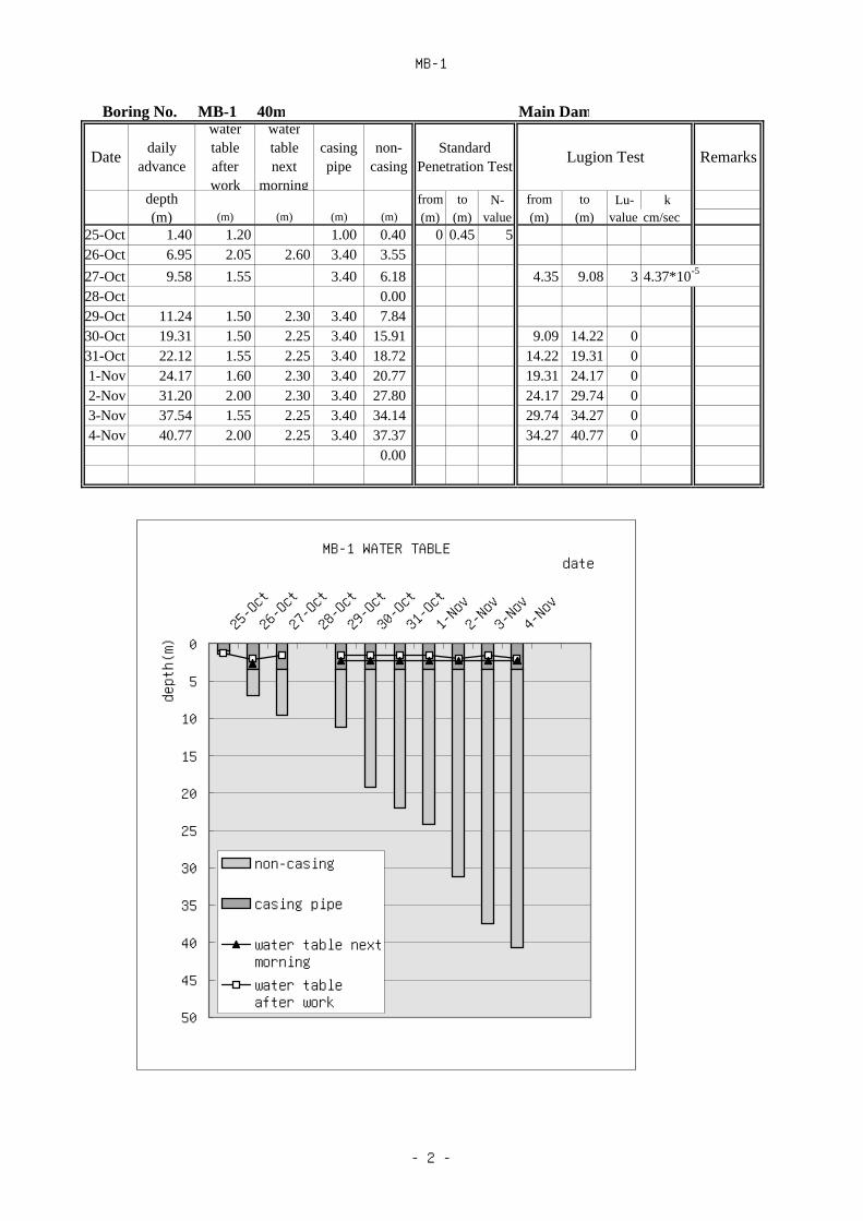
MB-1
Boring No. MB-1 40m Main Dam
Datedaily
advance
watertableafterwork
watertablenext
morning
casingpipe
non-casing
StandardPenetration Test
Lugion Test Remarks
depth from to N- from to Lu- k(m) (m) (m) (m) (m) (m) (m) value (m) (m) value cm/sec
25-Oct 1.40 1.20 1.00 0.40 0 0.45 526-Oct 6.95 2.05 2.60 3.40 3.5527-Oct 9.58 1.55 3.40 6.18 4.35 9.08 3 4.37*10-5
28-Oct 0.0029-Oct 11.24 1.50 2.30 3.40 7.8430-Oct 19.31 1.50 2.25 3.40 15.91 9.09 14.22 031-Oct 22.12 1.55 2.25 3.40 18.72 14.22 19.31 01-Nov 24.17 1.60 2.30 3.40 20.77 19.31 24.17 02-Nov 31.20 2.00 2.30 3.40 27.80 24.17 29.74 03-Nov 37.54 1.55 2.25 3.40 34.14 29.74 34.27 04-Nov 40.77 2.00 2.25 3.40 37.37 34.27 40.77 0 0.00
MB-1 WATER TABLE
0
5
10
15
20
25
30
35
40
45
50
25-Oct
26-Oct
27-Oct
28-Oct
29-Oct
30-Oct
31-Oct
1-Nov2-Nov3-Nov4-Nov
date
depth(m)
non-casing
casing pipe
water table nextmorningwater tableafter work
- 2 -

MB-2
Boring No. MB-2 40m Main Dam
Datedaily
advance
watertableafter
watertablenext
casingpipe
non-casing
StandardPenetration Test
Lugion Test Remarks
depth from to N- from to Lu- k(m) (m) (m) (m) (m) (m) (m) value (m) (m) value cm/sec
11-Oct 3.76 2.60 0.00 3.76 1.00 5.30 1 85*10-5
12-Oct 7.62 2.60 3.10 0.00 7.62 5.30 9.85 0 39*10-7
13-Oct 9.14 2.30 3.10 0.00 9.14 9.85 14.80 0 29*10-7
14-Oct 15.67 2.10 2.45 0.00 15.67 14.80 19.54 0 08*10-7
15-Oct 22.34 2.20 2.20 0.00 22.34 19.54 24.05 0 46*10-8
16-Oct 28.17 2.20 2.25 0.00 28.17 24.05 29.93 0 15*10-8
17-Oct 36.71 2.20 1.70 0.00 36.71 29.93 35.25 0 88*10-8
18-Oct 40.13 1.70 1.70 0.00 40.13 35.25 40.13 0 06*10-7
MB-2 WATER TABLE
0
5
10
15
20
25
30
35
40
45
50
11-Oct
12-Oct
13-Oct
14-Oct
15-Oct
16-Oct
17-Oct
18-Oct
date
depth(m)
non-casing
casing pipe
water table nextmorningwater tableafter work
- 3 -

MB-3
Boring No. MB-3 50m (50 degrees) Main Dam
Datedaily
advance
watertableafter
watertablenext
casingpipe
non-casing
StandardPenetration Test
Lugion Test Remarks
depth from to N- from to Lu- k(m) (m) (m) (m) (m) (m) (m) value (m) (m) value cm/sec
6-Dec 2.50 1.16 2.50 0.65 5 0.007-Dec 5.00 2.45 1.23 5.00 5 10 0.008-Dec 0.00 10 15 0.009-Dec 8.00 2.46 2.53 8.00 15 20 0.00
10-Dec 11.00 2.56 2.65 11.00 15 20 0.0011-Dec 14.00 2.54 2.63 14.00 20 25 0.0012-Dec 17.00 2.36 2.60 17.00 25 30 0.0013-Dec 20.00 2.35 2.58 20.00 30 35 0.0014-Dec 24.00 2.30 2.55 24.00 35 40 0.0016-Dec 28.00 0.00 2.38 28.00 40 45 0.0017-Dec 32.00 0.00 0.00 32.00 45 50 0.0018-Dec 36.00 0.00 0.00 36.0019-Dec 40.00 0.00 0.00 40.0020-Dec 45.00 0.00 0.00 45.0021-Dec 50.00 0.00 0.00 50.00
MB-3 WATER TABLE
0
5
10
15
20
25
30
35
40
45
50
6-Dec
7-Dec
8-Dec
9-Dec
10-Dec
11-Dec
12-Dec
13-Dec
14-Dec
16-Dec
17-Dec
18-Dec
19-Dec
20-Dec
21-Dec
date
depth(m)
non-casing
casing pipe
water table nextmorningwater tableafter work
- 4 -

MB-4
Boring No. MB-4 40m Main Dam
Datedaily
advance
watertableafter
watertablenext
casingpipe
non-casing
StandardPenetration Test
Lugion Test Remarks
depth from to N- from to Lu- k(m) (m) (m) (m) (m) (m) (m) value (m) (m) value cm/sec
26-Dec 6.00 3.36 4.75 1.25 5 10 027-Dec 12.00 1.42 3.85 4.75 7.25 10 15 028-Dec 17.55 1.40 1.68 4.75 12.80 15 20 029-Dec 25.00 15.10 1.95 4.75 20.25 20 25 030-Dec 34.00 16.74 17.23 4.75 29.25 30 35 031-Dec 40.00 10.16 9.39 4.75 35.25
MB-4 WATER TABLE
0
5
10
15
20
25
30
35
40
45
50
26-Dec
27-Dec
28-Dec
29-Dec
30-Dec
31-Dec
date
depth(m)
non-casing
casing pipe
water table nextmorningwater tableafter work
- 5 -

CT-1
Boring No. CT-1 20m Conduit Trace
Datedaily
advance
watertableafter
watertablenext
casingpipe
non-casing
StandardPenetration Test
Lugion Test Remarks
depth from to N- from to Lu- k(m) (m) (m) (m) (m) (m) (m) value (m) (m) value cm/sec
21-Nov 10.00 1.60 10.00 0.00 0.00 0.45 422-Nov 15.35 6.00 9.10 11.72 3.63 1.55 2.00 523-Nov 20.00 6.28 6.78 11.72 8.28 3.00 3.45 7
4.55 5.00 46.00 6.45 87.55 8.00 29.00 9.45 4
10.55 11.00 9
CT-1 WATER TABLE
0
5
10
15
20
25
30
35
40
45
50
21-Nov
22-Nov
23-Nov
date
depth(m)
non-casing
casing pipe
water table nextmorningwater tableafter work
- 6 -

CT-2
Boring No. CT-2 15m Conduit Trace
Datedaily
advance
watertableafter
watertablenext
casingpipe
non-casing
StandardPenetration Test
Lugion Test Remarks
depth from to N- from to Lu- k(m) (m) (m) (m) (m) (m) (m) value (m) (m) value cm/sec
2-Nov 3.00 0.00 0.00 0.00 3.003-Nov4-Nov5-Nov6-Nov 4.00 1.10 1.52 0.00 4.007-Nov 9.00 1.96 2.10 0.00 9.00 2.5 7 08-Nov 13.55 1.64 2.21 0.00 13.55 7 12 09-Nov 15.50 2.13 2.29 0.00 15.50 12 15.5 0
CT-2 WATER TABLE
0
5
10
15
20
25
30
35
40
45
50
2-Nov3-Nov4-Nov5-Nov6-Nov7-Nov8-Nov9-Nov
date
depth(m)
non-casing
casing pipe
water table nextmorningwater tableafter work
- 7 -

MT-1
Boring No. MT-1 30m Main Tunnel
Datedaily
advance
watertableafter
watertablenext
casingpipe
non-casing
StandardPenetration Test
Lugion Test Remarks
depth from to N- from to Lu- k(m) (m) (m) (m) (m) (m) (m) value (m) (m) value cm/sec
11-Oct 6.45 2.43 4.02 0.00 0.45 312-Oct 11.20 9.83 1.37 1.50 1.95 513-Oct 3.10 3.55 1114-Oct 4.50 4.95 1215-Oct 19.00 10.25 9.83 9.17 6.00 6.45 1416-Oct 27.00 17.95 14.30 9.83 17.17 7.50 7.85 4617-Oct 30.00 23.46 19.33 9.83 20.17 9.00 9.45 3418-Oct 35.54 23.32 19.36 9.83 25.71 30.00 35.54 0.4 5.57*10-6
MT-1 WATER TABLE
0
5
10
15
20
25
30
35
40
45
50
11-Oct
12-Oct
13-Oct
14-Oct
15-Oct
16-Oct
17-Oct
18-Oct
date
depth(m)
non-casing
casing pipe
water table nextmorningwater tableafter work
- 8 -
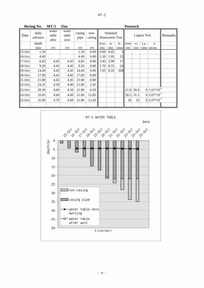
MT-2
Boring No. MT-2 35m Penstock
Datedaily
advance
watertableafter
watertablenext
casingpipe
non-casing
StandardPenetration Test
Lugion Test Remarks
depth from to N- from to Lu- k(m) (m) (m) (m) (m) (m) (m) value (m) (m) value cm/sec
15-Oct 1.50 1.50 0.00 0.00 0.45 316-Oct 4.40 4.40 0.00 1.50 1.95 2517-Oct 6.65 4.45 4.45 6.65 0.00 3.45 3.90 1718-Oct 9.20 4.45 4.45 9.20 0.00 5.70 6.55 2419-Oct 14.60 4.45 4.45 14.60 0.00 7.65 8.10 HB20-Oct 17.00 4.45 4.45 17.00 0.0021-Oct 21.80 4.45 4.45 21.00 0.8022-Oct 24.25 4.50 4.40 21.80 2.4523-Oct 28.30 4.60 4.50 21.80 6.50 21.8 26.8 0 1.01*10-6
24-Oct 33.85 4.60 4.60 21.80 12.05 26.5 31.5 0 5.07*10-7
25-Oct 35.00 4.70 4.60 21.80 13.20 30 35 0 5.07*10-7
MT-2 WATER TABLE
0
5
10
15
20
25
30
35
40
45
50
15-Oct
16-Oct
17-Oct
18-Oct
19-Oct
20-Oct
21-Oct
22-Oct
23-Oct
24-Oct
25-Oct
date
depth(m)
k(cm/sec)
non-casing
casing pipe
water table nextmorningwater tableafter work
- 9 -

MT-3
Boring No. MB-3 25m Penstock
Datedaily
advance
watertable after
work
watertable nextmorning
casingpipe
non-casing
Standard PenetrationTest
Lugion Test Remarks
depth from to N- from to Lu- k(m) (m) (m) (m) (m) (m) (m) value (m) (m) valu cm/se
28-Nov 4.55 1.80 4.15 0.40 0.00 0.45 8 4.15 9.15 0.829-Nov 7.45 5.15 4.10 4.15 3.30 1.95 2.40 54 9.15 14.15 0.730-Nov
1-Dec2-Dec3-Dec 13.65 5.15 4.15 9.50 3.90 4.15 28 14.15 19.15 0.74-Dec 20.70 6.10 11.60 4.15 16.55 19.15 24.15 05-Dec 25.50 4.15 21.35 24.15 25.5 06-Dec
MT-3 WATER TABLE
0
5
10
15
20
25
30
35
40
45
50
28-Nov
29-Nov
30-Nov
1-Dec2-Dec3-Dec4-Dec5-Dec6-Dec
date
depth(m)
non-casing
casing pipe
water table nextmorningwater tableafter work
- 10 -

MT-4
Boring No. MT-4 30m Penstock
Datedaily
advance
watertableafter
watertablenext
casingpipe
non-casing
StandardPenetration Test
Lugion Test Remarks
depth from to N- from to Lu- k(m) (m) (m) (m) (m) (m) (m) value (m) (m) value cm/sec
29-Oct 3.90 3.90 0.00 0 0.45 8 30-Oct 0.00 2 2.4 1531-Oct 0.00 3.9 4.35 151-Nov 0.00 5.9 6.3 272-Nov 8.25 8.25 8.25 0.00 7.8 8.25 313-Nov 16.00 8.70 8.25 14.25 1.754-Nov 17.00 8.30 15.30 17.00 0.005-Nov 19.00 8.30 15.30 17.00 2.006-Nov 0.007-Nov 0.008-Nov 21.00 8.30 15.60 17.00 4.00 9-Nov 25.05 9.10 16.45 17.00 8.05 17 21.9 0 2.7*10-6
10-Nov 27.75 9.10 16.45 17.00 10.75 2.19 27.1 0 3.8*10-6
11-Nov 30.55 9.10 16.45 17.00 13.55 27.1 30.6 0 3.9*10-6
MT-4 WATER TABLE
0
5
10
15
20
25
30
35
40
45
50
29-Oct
31-Oct
2-Nov4-Nov6-Nov8-Nov10-Novdate
depth(m)
non-casing
casing pipe
water table nextmorningwater tableafter work
- 11 -
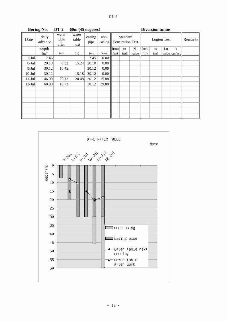
DT-2
Boring No. DT-2 60m (45 degrees) Diversion tunnel
Datedaily
advance
watertableafter
watertablenext
casingpipe
non-casing
StandardPenetration Test
Lugion Test Remarks
depth from to N- from to Lu- k(m) (m) (m) (m) (m) (m) (m) value (m) (m) value cm/sec
7-Jul 7.45 7.45 0.008-Jul 20.10 8.32 15.24 20.10 0.009-Jul 30.12 10.45 30.12 0.00
10-Jul 30.12 15.18 30.12 0.0011-Jul 46.00 20.13 20.48 30.12 15.8812-Jul 60.00 18.73 30.12 29.88
DT-2 WATER TABLE
0
5
10
15
20
25
30
35
40
45
50
55
60
7-Jul8-Jul9-Jul10-Jul
11-Jul
12-Jul
date
depth(m)
non-casing
casing pipe
water table nextmorningwater tableafter work
- 12 -

MB-5
Boring No. MB-5 30m Main Dam
Datedaily
advance
watertableafterwork
watertablenext
morning
casingpipe
non-casing
StandardPenetration Test
Lugion Test Remarks
depth from to N- from to Lu- k(m) (m) (m) (m) (m) (m) (m) value (m) (m) value cm/sec
18-Sep 1.00 1.00 0.00 1 1.45 1 6.20-7.2019-Sep 3.15 2.20 2.20 0.95 water loss20-Sep 5.65 4.35 4.35 2.20 3.45 3.25 8.50 >5021-Sep 7.20 7.20 4.20 2.20 5.00 8.50 13.50 022-Sep 8.50 4.20 3.75 2.20 6.30 13.50 19.20 023-Sep 11.50 3.60 4.40 2.20 9.30 19.50 25.50 2.124-Sep 17.70 4.35 8.60 2.20 15.5025-Sep 25.50 5.20 6.35 2.20 23.3026-Sep 30.15 4.45 2.20 27.95
MB-5 WATER TABLE
0
5
10
15
20
25
30
35
40
45
50
18-Sep
19-Sep
20-Sep
21-Sep
22-Sep
23-Sep
24-Sep
25-Sep
26-Sep
date
depth(m)
non-casing
casing pipe
water table nextmorningwater tableafter work
- 13 -

CT-3
Boring No. CT-3 20m Conduit
Datedaily
advance
watertableafter
watertablenext
casingpipe
non-casing
StandardPenetration Test
Lugion Test Remarks
depth from to N- from to Lu- k(m) (m) (m) (m) (m) (m) (m) value (m) (m) value cm/sec
28-Sep 4.20 3.50 4.20 0.00 1.50 1.95 529-Sep 13.20 3.00 11.20 2.00 3.00 3.15 1030-Sep 18.10 4.60 16.95 1.15 4.50 >50
1-Oct 20.35 4.05 16.95 3.40 15.00 >50
MB-2 WATER TABLE
0
5
10
15
20
25
30
35
40
45
50
28-Sep
29-Sep
30-Sep
1-Oct
date
depth(m)
non-casing
casing pipe
water table nextmorningwater tableafter work
- 14 -

CT-4
Boring No. CT-4 20m Conduit
Datedaily
advance
watertableafter
watertablenext
casingpipe
non-casing
StandardPenetration Test
Lugion Test Remarks
depth from to N- from to Lu- k(m) (m) (m) (m) (m) (m) (m) value (m) (m) value cm/sec
7-Oct 4.50 0.50 4.50 0.00 1.50 1.95 18-Oct 7.50 0.50 0.50 6.00 1.50 3.00 3.45 79-Oct 12.45 0.70 0.50 12.00 0.45 6.00 6.45 9
10-Oct 18.25 2.20 18.25 0.00 7.50 7.75 2411-Oct 20.00 18.25 1.75 9.00 9.45 20
10.50 10.95 1712.00 12.45 2314.00 14.45 11
CT-4 WATER TABLE
0
5
10
15
20
25
30
35
40
45
50
7-Oct
8-Oct
9-Oct
10-Oct
11-Oct
date
depth(m)
non-casing
casing pipe
water table nextmorningwater tableafter work
- 15 -

MT-5
Boring No. MT-5 30m Main Tunnel
Datedaily
advance
watertableafter
watertablenext
casingpipe
non-casing
StandardPenetration Test
Lugion Test Remarks
depth from to N- from to Lu- k(m) (m) (m) (m) (m) (m) (m) value (m) (m) value cm/sec
22-Aug 3.00 3.00 0.00 0.00 0.45 4 14.1 m leak
23-Aug 5.95 5.95 0.00 1.50 1.95 5 17.64 m leak
24-Aug 8.25 5.60 8.25 0.00 3.00 3.45 5 28.25 m leak
25-Aug 13.25 12.90 0.35 4.50 4.95 426-Aug 17.20 13.20 15.00 2.20 7.00 7.45 2627-Aug 18.90 17.30 1.60 9.25 9.70 5829-Aug 21.25 18.05 3.20 10.80 11.25 4530-Aug 21.25 19.05 2.20 18m- collapse
31-Aug 23.60 21.25 2.351-Sep 27.50 25.65 1.853-Sep 30.25 28.90 1.354-Sep 30.25
MT-5 WATER TABLE
0
5
10
15
20
25
30
35
40
45
50
22-Aug
23-Aug
24-Aug
25-Aug
26-Aug
27-Aug
29-Aug
30-Aug
31-Aug
1-Sep3-Sep4-Sep
date
depth(m)
non-casing
casing pipe
water table nextmorningwater tableafter work
- 16 -

MT-6
Boring No. MT-6 40m Main Tunnel
Datedaily
advance
watertableafter
watertablenext
casingpipe
non-casing
StandardPenetration Test
Lugion Test Remarks
depth from to N- from to Lu- k(m) (m) (m) (m) (m) (m) (m) value (m) (m) value cm/sec
6-Sep 2.15 1.95 0.20 0.00 0.45 1 22.65 m leak
7-Sep 4.00 4.00 0.00 1.50 1.95 57 38.95 m leak
8-Sep 9.70 8.60 9.70 0.00 3.00 3.45 619-Sep 15.80 13.90 1.90 5.75 6.20 16
10-Sep 21.10 21.10 0.00 9.25 9.70 7411-Sep 10.65 11.10 3312-Sep 23.35 21.65 22.35 1.00 12.40 12.60 >5013-Sep 29.20 23.40 28.45 28.20 1.0014-Sep 34.70 28.45 34.70 0.0015-Sep 40.10 28.45 38.00 2.10
MT-6 WATER TABLE
0
5
10
15
20
25
30
35
40
45
50
6-Sep7-Sep8-Sep9-Sep10-Sep
11-Sep
12-Sep
13-Sep
14-Sep
15-Sep
date
depth(m)
non-casing
casing pipe
water table nextmorningwater tableafter work
- 17 -

MT-7
Boring No. MT-7 60 m Surge Chamber
Datedaily
advance
watertableafter
watertablenext
casingpipe
non-casing
StandardPenetration Test
Lugion Test Remarks
depth from to N- from to Lu- k(m) (m) (m) (m) (m) (m) (m) value (m) (m) value cm/sec
17-Sep 5.00 5.00 0.00 0.00 0.45 6 25.50 29.00 0.118-Sep 12.38 7.89 9.04 6.72 5.66 1.55 2.00 8 29.00 34.36 0.319-Sep 20.00 10.95 6.72 13.28 3.00 3.45 16 34.25 39.00 020-Sep 20.00 10.92 6.72 13.28 4.55 5.00 12 39.00 44.00 021-Sep 25.00 24.86 18.95 20.48 4.52 6.00 6.45 7 43.90 49.00 022-Sep 29.00 18.90 18.90 20.48 8.52 7.55 7.68 >50 49.00 54.00 023-Sep 31.50 18.90 18.95 20.48 11.02 9.00 9.27 >50 54.00 59.00 024-Sep 34.36 18.92 19.10 20.48 13.88 10.55 11.00 42 57.50 60.00 025-Sep 37.00 19.10 20.48 16.52 12.00 12.38 >5026-Sep 19.14 0.00 13.00 13.45 1627-Sep 40.00 19.10 19.15 20.48 19.52 15.00 15.45 1428-Sep 42.00 19.12 19.16 20.48 21.52 16.55 17.00 1829-Sep 44.00 19.12 19.12 20.48 23.52 18.00 18.24 >5030-Sep 48.37 19.10 19.11 20.48 27.89 19.55 19.68 >50
1-Oct 51.16 19.10 19.12 20.48 30.682-Oct 53.00 19.10 19.14 20.48 32.523-Oct 19.14 0.004-Oct 56.00 19.11 19.12 20.48 35.525-Oct 59.00 19.10 19.15 20.48 38.526-Oct 60.00 19.12 20.48 39.52
MT-7 WATER TABLE
0
5
10
15
20
25
30
35
40
45
50
55
60
17-Sep
19-Sep
21-Sep
23-Sep
25-Sep
27-Sep
29-Sep
1-Oct3-Oct5-Oct
date
depth(m)
non-casing
casing pipe
water table nextmorningwater tableafter work
- 18 -

MT-8
Boring No. MT-8 80m Main Tunnel
Datedaily
advance
watertableafter
watertablenext
casingpipe
non-casing
StandardPenetration Test
Lugion Test Remarks
depth from to N- from to Lu- k(m) (m) (m) (m) (m) (m) (m) value (m) (m) value cm/sec
12-Aug 1.60 1.45 1.60 0.00 0.00 0.45 5 16.50 20.00 0.4 72.06 m leak
13-Aug 9.50 7.53 7.68 1.60 7.90 2.00 2.24 >50 19.50 24.55 0.315-Aug 16.18 3.35 12.18 24.60 29.00 0.016-Aug 29.00 34.00 0.018-Aug 16.18 2.88 16.00 0.18 34.00 39.00 0.019-Aug 20.00 2.69 2.89 16.00 4.00 39.15 44.63 0.020-Aug 24.55 2.75 2.92 16.00 8.55 44.50 49.00 0.022-Aug 28.10 2.77 2.90 16.00 12.10 49.00 54.00 0.023-Aug 30.00 2.69 2.91 16.00 14.00 54.00 59.00 0.026-Aug 34.00 2.78 2.97 16.00 18.00 59.00 64.00 0.027-Aug 37.07 2.90 2.96 16.00 21.07 64.00 69.00 0.028-Aug 39.00 2.88 3.01 16.00 23.00 69.00 74.00 26.6 3.54×10⁻⁴
30-Aug 44.63 2.92 3.02 16.00 28.63 73.50 78.46 0.031-Aug 49.00 2.94 3.04 16.00 33.00 78.00 80.06 0.1
1-Sep 50.75 2.97 3.04 16.00 34.753-Sep 57.00 3.62 3.04 16.00 41.004-Sep 63.61 3.84 3.02 16.00 47.615-Sep 69.00 3.98 3.16 16.00 53.006-Sep 74.00 3.98 12.84 16.00 58.007-Sep 78.46 12.82 12.94 16.00 62.468-Sep 80.06 12.86 12.95 16.00 64.06
MT-8 WATER TABLE
05101520253035404550556065707580
12-Aug
15-Aug
18-Aug
20-Aug
23-Aug
27-Aug
30-Aug
1-Sep4-Sep6-Sep8-Sep
date
depth(m)
non-casing
casing pipe
water table nextmorningwater tableafter work
- 19 -

TR-1
Boring No. TR-1 35m Tailrace
Datedaily
advance
watertableafter
watertablenext
casingpipe
non-casing
StandardPenetration Test
Lugion Test Remarks
depth from to N- from to Lu- k(m) (m) (m) (m) (m) (m) (m) value (m) (m) value cm/sec
10-Oct 6.00 5.13 5.38 4.50 1.50 0.00 0.45 6 9.5 14 011-Oct 9.44 7.62 6.00 3.44 1.55 2.00 48 14 19 012-Oct 10.00 7.26 6.00 4.00 3.00 3.27 >50 19.5 25.3 013-Oct 7.84 0.00 4.50 4.68 >5014-Oct 14.00 7.56 7.96 6.00 8.0015-Oct 19.00 7.92 8.10 6.00 13.0016-Oct 24.00 8.02 8.15 6.00 18.0017-Oct 25.30 8.06 6.00 19.3018-Oct 0.0019-Oct 0.0020-Oct 0.00
TR-1 WATER TABLE
0
5
10
15
20
25
30
35
40
45
50
10-Oct
11-Oct
12-Oct
13-Oct
14-Oct
15-Oct
16-Oct
17-Oct
18-Oct
19-Oct
20-Oct
date
depth(m)
k(cm/sec)
non-casing
casing pipe
water table nextmorningwater tableafter work
- 20 -
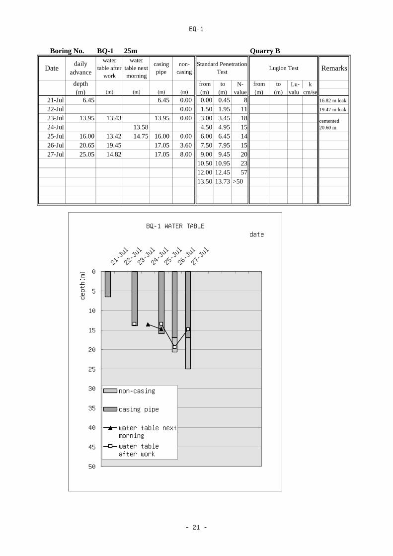
BQ-1
Boring No. BQ-1 25m Quarry B
Datedaily
advance
watertable after
work
watertable nextmorning
casingpipe
non-casing
Standard PenetrationTest
Lugion Test Remarks
depth from to N- from to Lu- k(m) (m) (m) (m) (m) (m) (m) value (m) (m) valu cm/se
21-Jul 6.45 6.45 0.00 0.00 0.45 8 16.82 m leak
22-Jul 0.00 1.50 1.95 11 19.47 m leak
23-Jul 13.95 13.43 13.95 0.00 3.00 3.45 1824-Jul 13.58 4.50 4.95 1525-Jul 16.00 13.42 14.75 16.00 0.00 6.00 6.45 1426-Jul 20.65 19.45 17.05 3.60 7.50 7.95 1527-Jul 25.05 14.82 17.05 8.00 9.00 9.45 20
10.50 10.95 2312.00 12.45 5713.50 13.73 >50
cemented20.60 m
BQ-1 WATER TABLE
0
5
10
15
20
25
30
35
40
45
50
21-Jul
22-Jul
23-Jul
24-Jul
25-Jul
26-Jul
27-Jul
date
depth(m)
non-casing
casing pipe
water table nextmorningwater tableafter work
- 21 -

BQ-2
Boring No. 25m Quarry C
Datedaily
advance
watertableafter
watertablenext
casingpipe
non-casing
StandardPenetration Test
Lugion Test Remarks
depth from to N- from to Lu- k(m) (m) (m) (m) (m) (m) (m) value (m) (m) value cm/sec
2-Oct 10.30 2.90 3.90 10.30 0.00 0 0.45 4 3-Oct 18.00 8.50 12.80 12.40 5.604-Oct 22.00 7.50 12.40 9.605-Oct 25.10 12.40 12.70
QB-2 WATER TABLE
0
5
10
15
20
25
30
35
40
45
50
2-Oct4-Oct
date
depth(m)
non-casing
casing pipe
water table nextmorningwater tableafter work
- 22 -

1.3 Photographs of Drilling Location and Drilling Core


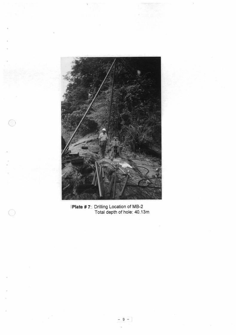


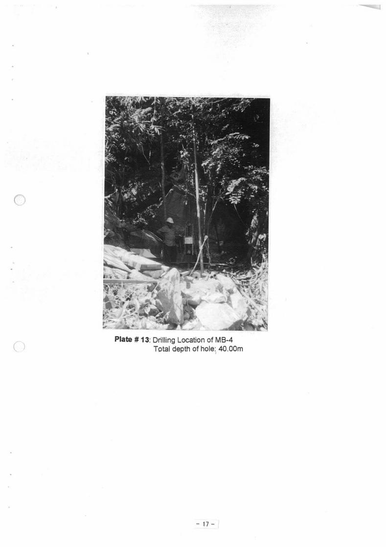


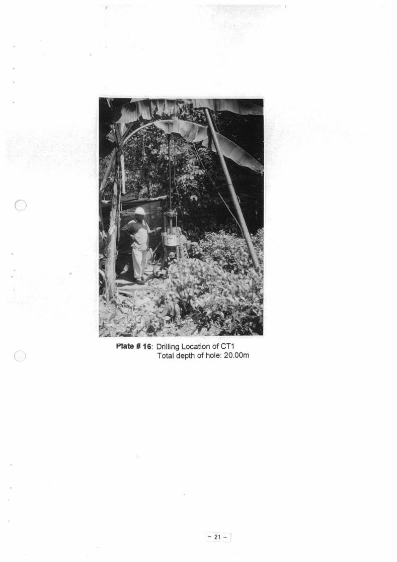


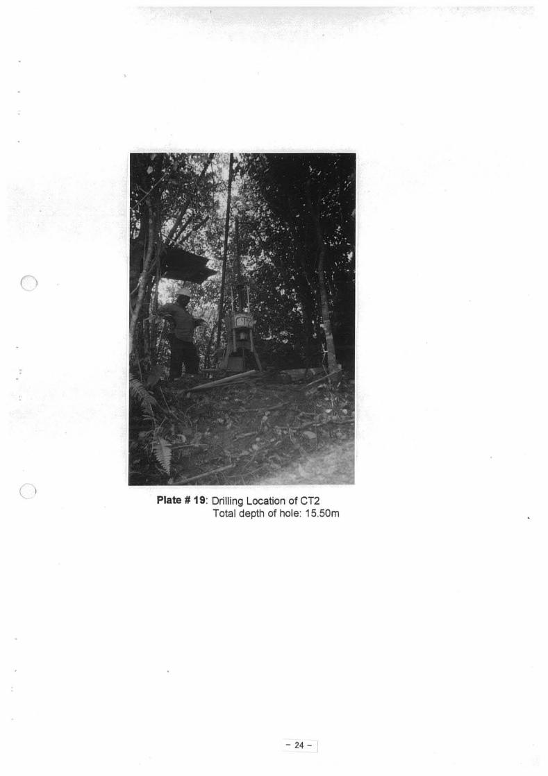


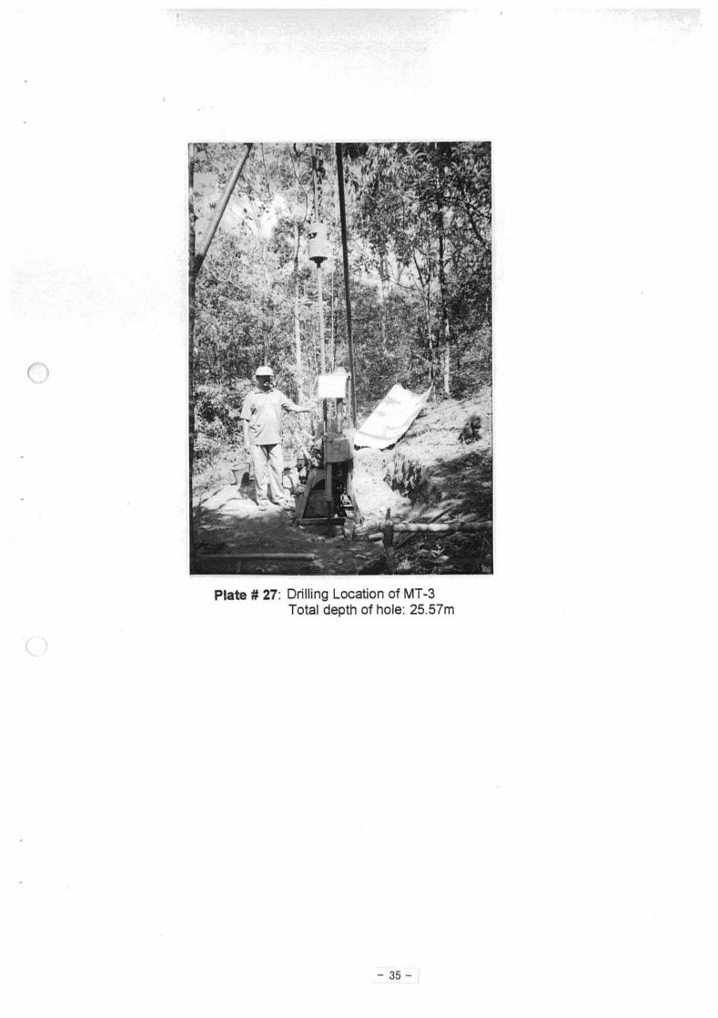


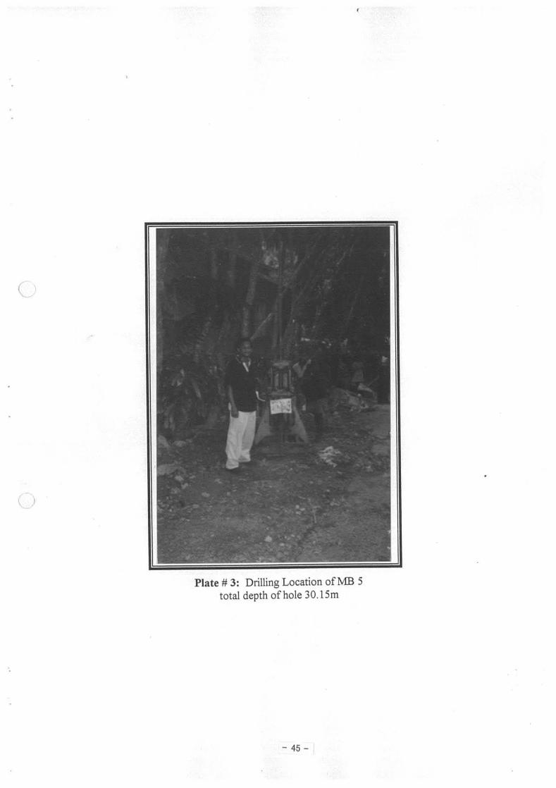


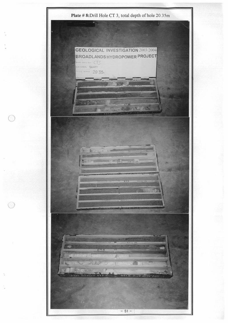


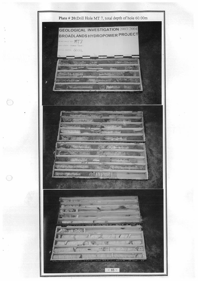

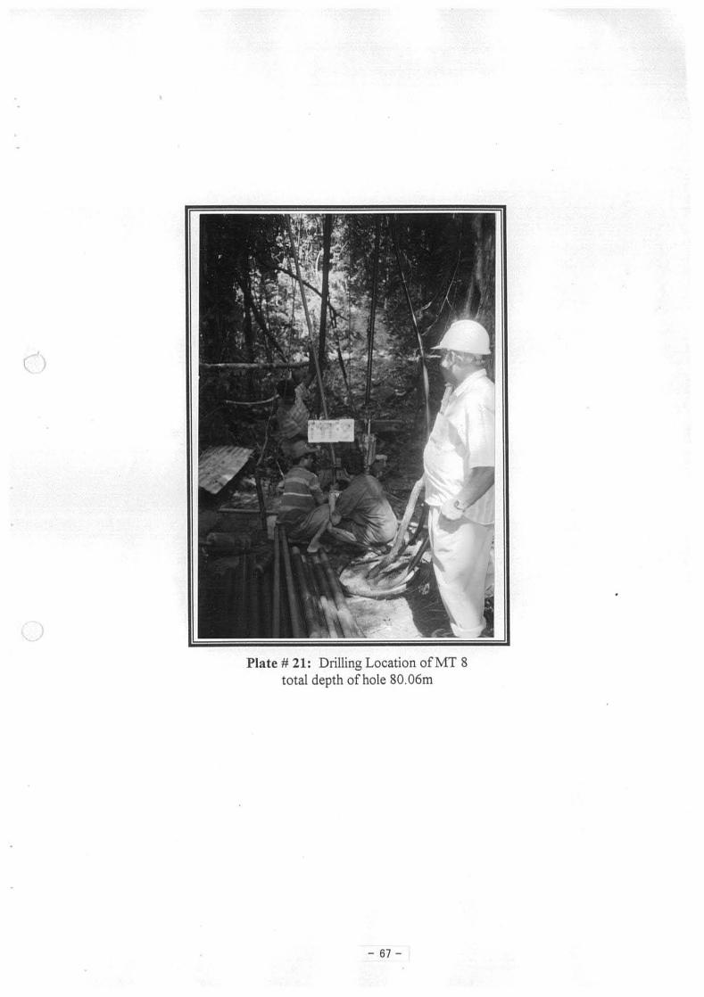


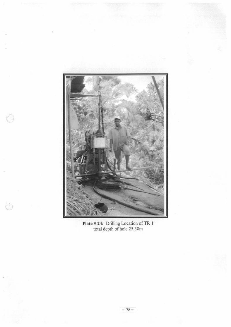

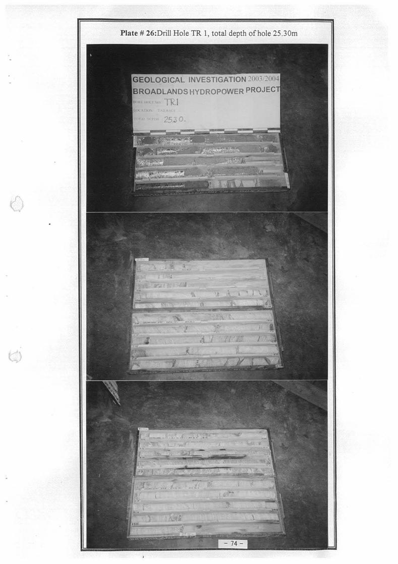


![Workshop Hydropower and Fish.pptx [Schreibgeschützt] - Workshop Hydropower and Fish... · Workshop Hydropower and Fish Existing hydropower facilities: ... spawning grounds and shelter](https://static.fdocuments.us/doc/165x107/5a8733247f8b9afc5d8da3c5/workshop-hydropower-and-fishpptx-schreibgeschtzt-workshop-hydropower-and-fishworkshop.jpg)