Geologic Mapping in the Talkeetna Mountains and Eastern ...alaskageology.org/documents/17/February...
21
Volume 47 Number 6 February 2017 Page 1 Geologic Mapping in the Talkeetna Mountains and Eastern Alaska Range: A Story of Mineralization and Deformation Evan Twelker Alaska Division of Geological & Geophysical Surveys, Fairbanks, AK [email protected] The Wrangellia terrane extends through the Eastern Alaska Range and Talkeetna Mountains as a narrow belt of rocks bordered by the Denali, Broxson Gulch, and Talkeetna fault systems to the north, and by the Strelna metamorphic complex to the south. This belt of rocks has been the target of exploration for nickel, copper and platinum-group-element deposits hosted by mafic to ultra- mafic intrusions related to the Late Triassic Nikolai Greenstone metabasalts. Exploration efforts have faced a number of challenges, including a lack of regional geologic mapping showing the lo- cation of prospective intrusions, and a lack of detailed work resolving the specific magmatic archi- tecture of the larger intrusions. Multiple episodes of poorly resolved post-Triassic faulting add fur- ther complications. (continued) AGS Luncheon Date & Time: Tuesday, February 21 h , 11:30 am – 1:00 pm Program: Geologic mapping in the Talkeetna Mountains and Eastern Alaska Range: A story of mineralizaƟon and deformaƟon Speaker: Evan Twelker, Alaska Division of Geological & Geophysical Surveys, Fairbanks, AK Place: BP Energy Center, 1014 Energy Court, Anchorage, AK Reservations: Make your reservation before noon Friday, February 17 th , 2016 Cost: Seminar only, no meal: Free Due to low demand catered lunch will no longer be available For more information call (907) 854-2363 or visit the AGS website: http://www.alaskageology.org
Transcript of Geologic Mapping in the Talkeetna Mountains and Eastern ...alaskageology.org/documents/17/February...

Volume 47 Number 6 February 2017 Page 1
Geologic Mapping in the Talkeetna Mountains and Eastern Alaska Range:
A Story of Mineralization and Deformation
Evan Twelker Alaska Division of Geological & Geophysical Surveys, Fairbanks, AK
The Wrangellia terrane extends through the Eastern Alaska Range and Talkeetna Mountains as a narrow belt of rocks bordered by the Denali, Broxson Gulch, and Talkeetna fault systems to the north, and by the Strelna metamorphic complex to the south. This belt of rocks has been the target of exploration for nickel, copper and platinum-group-element deposits hosted by mafic to ultra-mafic intrusions related to the Late Triassic Nikolai Greenstone metabasalts. Exploration efforts have faced a number of challenges, including a lack of regional geologic mapping showing the lo-cation of prospective intrusions, and a lack of detailed work resolving the specific magmatic archi-tecture of the larger intrusions. Multiple episodes of poorly resolved post-Triassic faulting add fur-ther complications. (continued)
AGS Luncheon Date & Time: Tuesday, February 21h, 11:30 am – 1:00 pm
Program: Geologic mapping in the Talkeetna Mountains and Eastern Alaska Range:
A story of mineraliza on and deforma on
Speaker: Evan Twelker, Alaska Division of Geological & Geophysical Surveys, Fairbanks, AK
Place: BP Energy Center, 1014 Energy Court, Anchorage, AK
Reservations: Make your reservation before noon Friday, February 17th, 2016
Cost: Seminar only, no meal: Free Due to low demand catered lunch will no longer be available
For more information call (907) 854-2363 or visit the AGS website: http://www.alaskageology.org

Volume 47 Number 6 February 2017 Page 2
About the Speaker: Evan Twelker joined the Mineral Resources Section of the DGGS in 2013. A native of Fairbanks and Ju-
neau, he received his B.A. from Middlebury College and his M.S. in geology from the University of Alaska Fairbanks under Professor Rainer Newberry. Evan has explored throughout Alaska, working in a variety of geologic settings and deposit types including the Ambler District, the Seward Peninsula, Greens Creek Mine, Livengood, the Pebble area, and the Galore Creek area of northwestern British Columbia. In his role at the DGGS, Evan specializes in bedrock mapping for the purpose of understanding Alaska's metallic mineral re-sources, and using geological, geophysical, and geochemical data to understand the formation of mineral de-posits in space and time. His current focus is on magmatic Ni-Cu-PGE mineralization hosted by the Wrangel-lia terrane in central Alaska.
In an effort to foster exploration success, the Alaska Division of Geological & Geophysical Surveys (DGGS) has invested in a multi-year, multi-disciplinary effort to improve the geologic knowledge of this area through geological mapping. This talk will show how the DGGS blends traditional ‘hammer and compass’ techniques with modern geochemical and geophysical technologies to address formation of mineralization during the Late Triassic, and how these rocks have been affected by tectonic events including the Jurassic amalgamation of Wrangellia and the Peninsular terranes, Cretaceous accretion and translation of Wrangellia with North America, and the ongoing uplift of the Alaska Range.
The 23-km-long, 700-m-thick, Butte Creek multi-phase gabbroic to ultra-mafic intrusive complex in the northwestern Talkeetna Mountains.
Thrust faulting related to Alaska Range uplift puts Late Triassic picrite volcan-ic rocks on top of Tertiary sedimentary rocks in the Rainy Creek area of the eastern Alaska Range.

Volume 47 Number 6 February 2017 Page 3
From the President’s Desk:
There are many AGS members that have been volunteering their time and working hard behind the scenes to help the society fulfill its mission. We have a new treasurer, Carla Phelps, who completed our tax-es for the last fiscal year that will be filed this month. Sue Karl has compiled a committee to review this year’s scholarship applications. Keith Torrance has been beating the bushes for volunteer speakers for the AGS monthly lecture series. Ken Helmold has stepped up to volunteer to be the AGS delegate to AAPG and will be attending the House of Delegates meeting at the annual meeting in Houston this spring. A large group of volunteers have been helping plan the PSAAPG May meeting, and Monte Mabry has been leading the plan-ning committee. Bev Burns, Jennifer Crews, and Tiffany Piercey have taken on significant responsibilities as co-chairs for the planning efforts. David Buthman has been busy with the treasurer responsibilities for the meeting. Four AGS members are leading three great field trips associated with the PSAAPG meeting: Mar-wan Wartes is leading a trip through the Brooks Range stratigraphy; Sue Karl is leading a trip from Hatcher Pass to Bird Point; and Dave LaPain and Ken Helmold are leading a trip through the Tertiary stratigraphy of Cook Inlet exposed along the Kenai Peninsula. A large contingent of AGS members are helping planning for the conference: Keith Torrance, Steve Wright, Ken Helmold, Tom Morahan.
It takes a great effort by a lot of volunteers to fulfill our mission to “promote interest in, and understanding of, the geology of Alaska” by offering monthly lectures, hosting annual technical conferences, and providing scholarships. I extend a sincere thank you to all the members who have volunteered to help with the func-tions of AGS. I also thank members for paying your dues and donating money to keep the society solvent. None of these great opportunities would exist without your support.
Cheers! ~Chad
My Pet Rock Tom Plawman
Gentleman Geologist
A thrust fault in the “Mile High Cliffs” above the Nizina River. Visible in the hanging wall, from the base upwards are the Triassic Niko-lai Greenstone, the Triassic Chitistone Limestone, and the Triassic Nizina Limestone. The Lower Jurassic to Upper Triassic McCarthy Formation is just visible at the very top of the cliff. For another view of this structure, with annotations, see Fig.22 in Winkler, Gary R.; 2000; A Geologic Guide to Wrangell-Saint Elias National Park and Preserve: USGS Professional Paper 1616.
I took this photo in 2006, on a 10-day, 200-mile raft trip, putting in at the base of the Nizina Glacier, floating down the Nizina River, into the Chitna River, then down into the into the Copper River, taking out at the Million Dollar Bridge.
Volume 47 Number 6 February 2017 Page 4
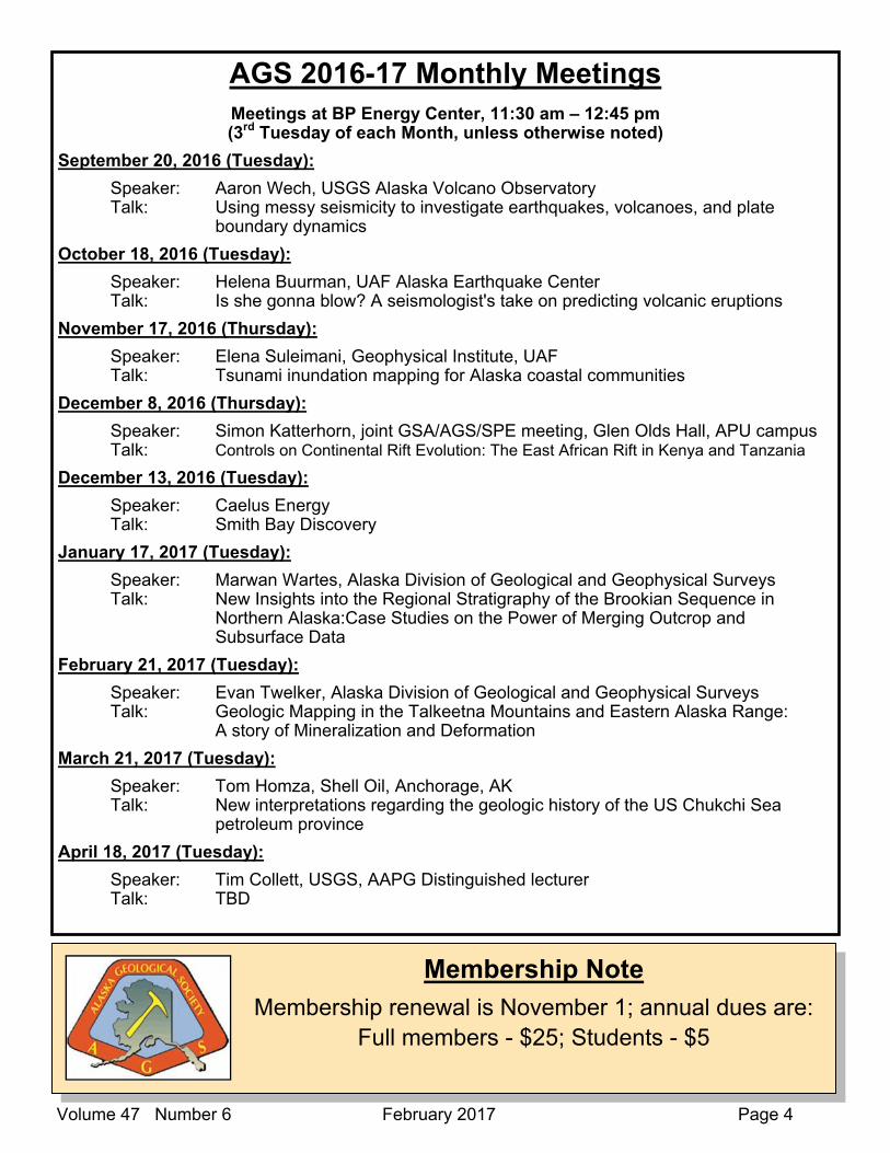
AGS 2016-17 Monthly Meetings Meetings at BP Energy Center, 11:30 am – 12:45 pm (3rd Tuesday of each Month, unless otherwise noted)
September 20, 2016 (Tuesday):
Speaker: Aaron Wech, USGS Alaska Volcano Observatory Talk: Using messy seismicity to investigate earthquakes, volcanoes, and plate boundary dynamics
October 18, 2016 (Tuesday):
Speaker: Helena Buurman, UAF Alaska Earthquake Center Talk: Is she gonna blow? A seismologist's take on predicting volcanic eruptions
November 17, 2016 (Thursday):
Speaker: Elena Suleimani, Geophysical Institute, UAF Talk: Tsunami inundation mapping for Alaska coastal communities
December 8, 2016 (Thursday):
Speaker: Simon Katterhorn, joint GSA/AGS/SPE meeting, Glen Olds Hall, APU campus Talk: Controls on Continental Rift Evolution: The East African Rift in Kenya and Tanzania
December 13, 2016 (Tuesday):
Speaker: Caelus Energy Talk: Smith Bay Discovery
January 17, 2017 (Tuesday):
Speaker: Marwan Wartes, Alaska Division of Geological and Geophysical Surveys Talk: New Insights into the Regional Stratigraphy of the Brookian Sequence in Northern Alaska:Case Studies on the Power of Merging Outcrop and Subsurface Data
February 21, 2017 (Tuesday):
Speaker: Evan Twelker, Alaska Division of Geological and Geophysical Surveys Talk: Geologic Mapping in the Talkeetna Mountains and Eastern Alaska Range: A story of Mineralization and Deformation
March 21, 2017 (Tuesday):
Speaker: Tom Homza, Shell Oil, Anchorage, AK Talk: New interpretations regarding the geologic history of the US Chukchi Sea petroleum province
April 18, 2017 (Tuesday):
Speaker: Tim Collett, USGS, AAPG Distinguished lecturer Talk: TBD
Membership Note
Membership renewal is November 1; annual dues are: Full members - $25; Students - $5

Volume 47 Number 6 February 2017 Page 5
OIL AND GAS SEEPS ON THE NORTHERN PART OF THE ALASKA PENINSULA
Robert B. Blodgett Consulting Geologist/Paleontologist
Blodgett & Associates, LLC 2821 Kingfisher Drive, Anchorage, Alaska 99502
Oil and gas seeps were the original historic indicators for the presence of hydrocarbon resources, and their presence has been noted dating back to the extraction of bitumen as far back 5,000 B.C. in the Tigris-Euphrates valley of Mesopotamia. In fact, nearly all of the original well sites in the early search of hydrocar-bons in North America were focused on locations near known oil and gas seeps.
Oil and gas seeps are extremely common in the northern part of Alaska Peninsula (notably the Puale Bay – Lake Becharof region) [Fig. 1] and in Lower Cook Inlet (Iniskin Peninsula). Such seeps were note noted by the Russians as early as 1857. These seeps figured prominently in the early geological reports by the U.S. Geo-logical Survey on the Alaska Peninsula (see Fig. 2). The loci of these seeps were key to the selection (together with structural geological interpretations) for sites selected for oil drilling up through the 1950s. The oil seeps on the northeastern Alaska Peninsula are typically occurring in Jurassic age strata exposed along the crests of prominent anticlinal axes (see Fig. 3 for location of the Ugashik Creek, Bear Creek, and Wide Bay anticlines).
The numerous naturally occurring oil and gas seeps in the northern Alaska Peninsula, as well as numerous oil and gas shows in the few wells which have adequately penetrated Mesozoic strata, indicate that oil and gas should be expected in much of the region, which seem likely to hold petroleum in both conventional and unconventional settings. Good petroleum source beds appear to be present regionally in both Upper Triassic and Middle Jurassic strata.
An interesting history of the role of oil seepages in the development of the “East Field” near Puale Bay can be found in Lee (1922) who reports:
“In the year 1900 H.A. Smith and Tom Hanmore hired a schooner and sent J.H. Lee and Hans Severson with same to look for oil seepages mentioned in Baranoff’s Russian History of Alaska, as reported by the Aleut Indians “back of Cold Bay”.
“In August Lee and Severson located two 16-acre claims, two 40-acre claims for the above mentioned gen-tlemen and other associates known as the “Sunrise Group” Capital. These prospectors visited the locations mentioned, collected oil samples and returned. Controversies arose concerning the method or procedure from this point, in consequence of which I have quite claim deeds to my interests.”
“I persuaded Lathrope and Johannsen to put up money against my time and returned to Cold Bay district and in March and April, 1901, located “Beaver Claims” Nos. 1, 2, 3 and 4, all near the head of Oil Creek in the vicinity of the claims previously staked. I then staked two at Dry Bay, four at Bear Creek, four on Salmon Creek, guiding my locations by the presence of seepages and following the apparent strike of the formations, according to my previous experiences in tracing the outcrop of metalliferous veins.”
“In 1901 I visited for the first time the region of Pearl Creek, because of reports given me by natives con-cerning a large seepage or residue patch, similar to the one on Oil Creek. I staked on Pearl Creek twelve claims for myself, Lathrope and Johannsen and bonded four of these in June to Costello.”
“In July 1901 Lathrope looked over the ground and departed to the States for the purpose of bonding the balance of these claims for development. Reaching Seattle he accidentally encountered Costello, who was then attempting to obtain claims in Iniskin Bay for development purposes. He bonded to Costello our claims at $26.00 an acre early in 1902. This was a two year bond with no cash payment.”
In this note most of the major oil and gas seeps in the region are discussed, and in some cases photodocu-mented . Primary sources for this data compilation include Blodgett and Clautice (2005), Blasko (1976a), and Cronin et al. (1999). Secondary souces include Becker and Manen (1989), Blasko (1976b), Capps (1923), Kellum et al. (1945), Martin (1904, 1905a, b, 1921), Smith (1926), and Smith and Baker (1924).

Volume 47 Number 6 February 2017 Page 6
Wide Bay region (from Blodgett and Clautice, 2005). Oil seeps shown in green and gas seeps are shown in red.Figure 1. Map show-ing known oil and gas seeps in the Puale Bay – Becharof Lake –

Volume 47 Number 6 February 2017 Page 7
Figure 2. U.S. Geological Survey field party led by W.R. Smith cooking break-fast during summer 1923 over natural gas seeps along the aptly named Gas Creek (NW of Becharof Lake near southern bound-ary of Katmai National Park). Gas appears to be emerging from stream gravels above Upper Ju-rassic Naknek Formation. This seep is shown as seep #1 in the northeast corner of Figure 1.
Figure 3. Map showing major anticlinal features in the northeastern part of the Alaska Peninsula (base map modified from Detterman et al., 1987).

Volume 47 Number 6 February 2017 Page 8
Oil seeps associated with the “West Field” (Pearl Creek Dome) near the axis of the Ugashik Creek anticline
The so-called “West Field” which was the locus of oil drilling on the Alaska Peninsula in the early 1920’s was obviously selected due to the presence of two major oil seeps (localities 11-12 in Figs. 3 and 4) along Barabara and Pearl Creek of originally usage (respectivally now shown as Little Ugashik and Barbara Creeks on the Ugashik C-1 quadrangle topographic sheet).
Figure 4. Reported oil seeps along the Ugashik Creek anticline (localities 11-13). Locality 11 is the largest seep in the entire Puale Bay - Lake Becharof region and is located on the north side of Barabara Creek (mislabeled Little Ugashik Creek on current USGS Ugashik C-1 quadrangle topographic sheet). Photos o f this seep are given in figures 5-9. All of these seeps are associated with near-by outcroppings of the Upper Jurassic Naknek Formation (from Blodgett and Clautice, 2005).

Volume 47 Number 6 February 2017 Page 9
Figure 5. Map from Capps (1923, Fig. 6) showing Barabara Creek oil seep (colored red) and correct original locations of Barabara Creek and Pearl Creek (note the current USGS topographic map of the Ugashik C-1 quadrangle incorrectly labels them as Little Ugashik and Barbara creeks, respectively).
Figure 6. Oil seepage along lower course of large oil seep on north side of Barabara Creek (mislabeled Little Ugashik Creek on current USGS Ugashik C-1 quadrangle topographic sheet). Seepage north of the “West Field” (Pearl Creek Dome) oil camp. Seepage referred to in Capps (1923), Smith and Baker (1924), and Smith (1926). Photo taken June 16, 2012.
Figure 7. Oil seepage in middle of large oil seep on north side of Barabara Creek (mislabeled Little Ugashik Creek on current USGS Ugashik C-1 quadrangle map). Photo taken June 16, 2012.
Figure 8. Oil seepage from upper end of large oil seep on north side of Barabara Creek (mislabeled Little Ugashik Creek on current USGS Ugashik C-1 quadrangle map). This is one of the largest and most oil-rich patches at this seep. Photo taken June 16, 2012.
Figure 9. Another view of the oil seepage shown above from upper end of large oil seep on north side of Barabara Creek (mislabeled Little Ugashik Creek on current USGS Ugashik C-1 quadrangle map). This is one of the largest and most oil-rich patches at this seep. June 16, 2012.
Figure 10. Another view of the same oil seepage shown in Figures 8-9. Photo taken June 16, 2012.

Volume 47 Number 6 February 2017 Page 10
OIL AND GAS SEEPS ASSOCIATED WITH THE “EAST FIELD” NEAR THE AXIS OF THE BEAR CREEK ANTICLINE
The so-called “East Field” represents an area of numerous documented oil and gas seeps (see localities 3-10 in Fig. 1 and Fig. 11) associated with outcroppings of the upper Middle Jurassic Shelikof Formation along the anticlinal axis as well as the flanks of the Bear Creek anticline (earlier referred to as the Salmon Creek-Bear Creek anticline in Capps (1923), Smith and Baker (1924), and Smith (1926). These seeps were the pri-mary lure to bringing in petroleum explorationists to the upper Alaska Peninsula during the first decade of the 20th Century and later on in the 1930s and 1950s. Five cable-tool drilled wells were drilled along the structure (J.H. Costello #1 and #2 and Pacific Oil and Commerical Company #1, #2 and #3), as well as the rotary drilled Grammer #1 and Humble-Shell Bear Creek #1 wells (the latter well had been the most expensive well drilled in Alaska up to that date). 8 oil seeps and one gas seep have been documented along this trend (see Blodgett and Clautice, 2005) for details.
The writer has only visited the seeps situated along Oil Creek for which photographs of are provided in Fig-ures 12-18. The main oil seep (Figs. 12-14) along Oil Creek is the most visited seep historically in the region due to its large size, as well as the extensive tar mat (or residue patch) which exists just downstream of where it is currently seeping. It is situated in the NE1/4 Sec. 10, T. 29 S., R. 40 W., Karluk C-6 1:63,360 scale quadrangle. Blasko (1976a) provides geochemical data for this seam (his Seep A, both for oil and gas ema-nating from it, as well as from the large bitumen residue deposit situated nearby). The A.P.I. gravity value for this oil seep was reported by Blasko to be 15.7. Another nearby seep (his seep B, situated approximately 45
feet west of seep A) was also analyzed and was reported to have an A.P.I. gravity value of 21.4. Blasko (1976a) also pro-vided germane data and obser-vations on the other smaller seeps located along the Bear Creek anticline.
Figure 11. Map showing reported oil (green) and gas (red) seeps along the crest of the Bear Creek anticline (from Blodgett and Clautice, 2005). Locali-ties 3-5 are those along Oil Creek, shown in figures 12-17.

Volume 47 Number 6 February 2017 Page 11
Figure 12. Main oil seep on south side of upper reaches of Oil Creek near the crest of the Bear Creek anticline, Karluk C-6 quadrangle. Photograph taken by author May 30, 2004.
Figure 13. Small lake with oil entering into it from mail oil seep at Oil Creek. Seep visible at head of small channel in upper right corner of view. Photo-graph taken by author May 30, 2004.
Figure 14. Main oil seep along Oil Creek. Photo taken by author on May 30, 2004.
Figure 15. Oil seep issuing from fractured upper Middle Ju-rassic Shelikof Formation along Oil Creek. Photo taken by author May 31, 2004.
Figure 16. Small seepage along south side of Oil Creek slightly downstream from outcrop in figure above. Photo taken by author May 31, 2004.
Figure 17. Oil seep issuing from another fractured outcrop of the upper Middle Jurassic Shelikof Formation along Oil Creek. Photo taken May 31, 2004.

Volume 47 Number 6 February 2017 Page 12
Figure 18. Reported occurrence of oil seep (circle) and solid hydrocarbons from the Wide Bay area, Ugashik B-1 and B-2 quadrangles (from Blodgett and Clautice, 2005).
OIL SEEP AND SOLID HYDROCARBONS FOUND IN THE WIDE BAY AREA
A single oil seep (circle) and a report of solid hydrocarbons (square) are reported from the northern part of the lower Middle Jurassic Shelikof Formation (localities 14-15 of Blodgett and Clautice, 2005; see Fig. 18 be-low).
No confirmed reports of oil or gas seeps are reported to the south of the Puale Bay-Becharof Lake-Wide Bay area on the northeastern part of the Alaska Peninsula.
REFERENCES
Becker, P.R., and Manen, C.-A., 1989, Natural Oil seeps in the Alaskan marine environment: U.S. Depart-ment of Commerce, National and Oceanic Atmospheric Administration (NOAA), Outer Continental Shelf Environmental Assessment Program, Final Reports, v. 62, p. 1–126.
Blasko, D.P., 1976a, Oil and gas seeps in Alaska. Alaska Peninsula, western Gulf of Alaska: U.S. Bureau of Mines Report of Investigations 8122, 78 p.
Blasko, D.P., 1976b, Occurrences of oil and gas seeps along the Gulf of Alaska: Eighth Annual Offshore Technology Conference, 1976 Proceedings, v. 1, p. 211–220.
Blodgett, R.B., and Clautice, K.H., 2005, Oil and Gas Seeps of the Puale Bay – Becharof Lake - Wide Bay region, northern Alaska Peninsula: Alaska Division of Geological & Geophysical Surveys Preliminary Interpretative Report 2005-6, 13 p., 1 sheet.

Volume 47 Number 6 February 2017 Page 13
Capps, S.R., 1923, The Cold Bay district, in Mineral resources of Alaska; report on progress of investigations in 1921: U.S. Geological Survey Bulletin 739, p. 77 116.
Cronin, M.A., Brannon, M.A., Brannon, E., and Moulton, L., 1999, Natural oil seeps in the Puale Bay area of the Becharof National Wildlife Refuge, and the Blue Creek area of the Alaskan Peninsula National Wildlife Refuge, Alaska: A Report to Refuge Manager, Becharof National Wildlife Refuge, 7 p., 38 figs.
Detterman, R.L., Case, J.E., Wilson, F.H., and Yount, M.E., 1987, Geologic map of the Ugashik, Bristol Bay, and western of Karluk quadrangles, Alaska: U.S. Geological Survey Miscellaneous Investigations Se-ries Map I-1685, scale 1:250,000.
Kellum, L.B., Daviess, S.N., and Swinney, C.M., 1945, Geology and oil possibilities of the southwestern part of the Wide Bay anticline, Alaska: U.S. Geological Survey Special Publication, 17 p., 9 pls.
Lee, J.H., 1922, Statement concerning the early history of operations in the East Cold Bay Field, obtained by R.R. Morse from Jack Lee on July 6, 1922. Internal document of the Standard Oil Company of Califor-nia, 1 p. [Document No: Koniag Inc. 2009-01]
Martin, G.C., 1904, Petroleum fields of Alaska: U.S. Geological Survey Bulletin 225, p. 365–382.
Martin, G.C., 1905a, The petroleum fields of the Pacific coast of Alaska, with an account of the Bering River coal deposits: U.S. Geological Survey Bulletin 250, 64 p.
Martin, G.C., 1905b, Notes on the petroleum fields of Alaska: U.S. Geological Survey Bulletin 259, p. 128–139.
Martin, G.C., 1921, Preliminary report on petroleum in Alaska: U.S. Geological Survey Bulletin 719, 83 p.
Smith, W.R., 1926, Geology and oil development of the Cold Bay district, in Mineral Resources of Alaska; re-port on progress of investigations in 1924: U.S. Geological Survey Bulletin 783, p. 63-88.
Smith, W.R., and Baker, A.A., 1924, The Cold Bay-Chignik district, in Mineral resources of Alaska; report on progress of investigations in 1922: U.S. Geological Survey Bulletin 755, p. 151-218.

Volume 47 Number 6 February 2017 Page 14
Volume 47 Number 6 February 2017 Page 15
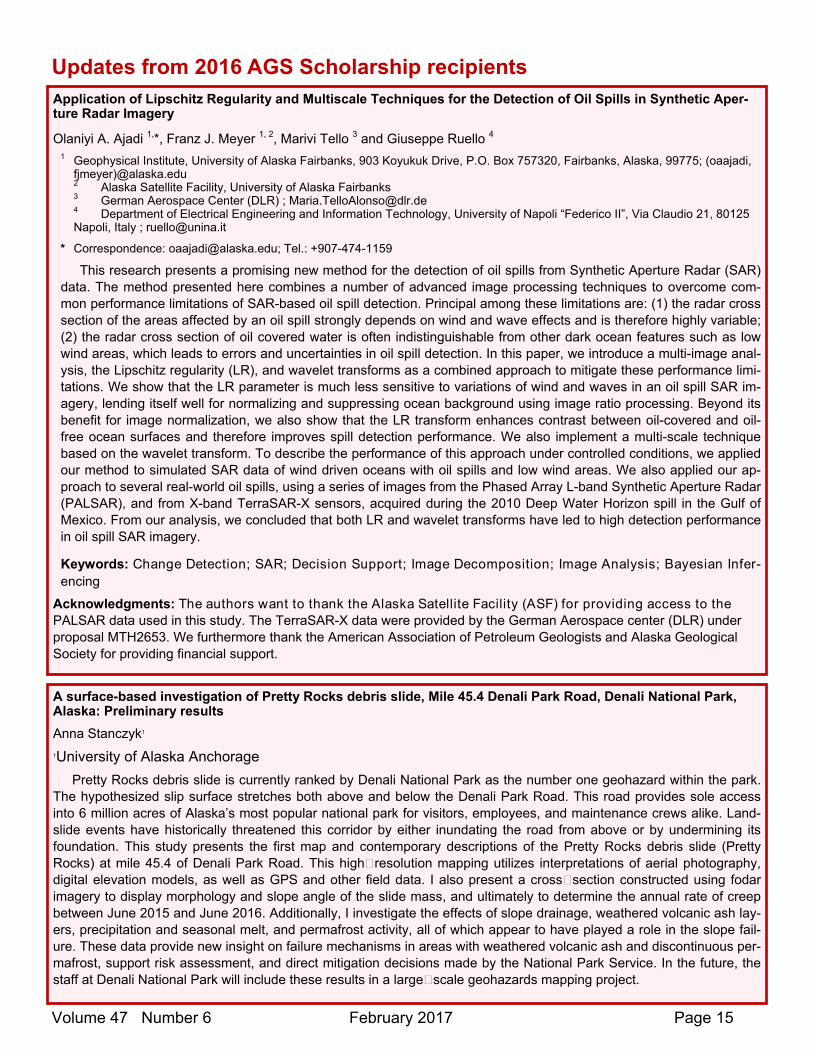
Application of Lipschitz Regularity and Multiscale Techniques for the Detection of Oil Spills in Synthetic Aper-ture Radar Imagery
Olaniyi A. Ajadi 1,*, Franz J. Meyer 1, 2, Marivi Tello 3 and Giuseppe Ruello 4 1 Geophysical Institute, University of Alaska Fairbanks, 903 Koyukuk Drive, P.O. Box 757320, Fairbanks, Alaska, 99775; (oaajadi,
fjmeyer)@alaska.edu 2 Alaska Satellite Facility, University of Alaska Fairbanks 3 German Aerospace Center (DLR) ; [email protected] 4 Department of Electrical Engineering and Information Technology, University of Napoli “Federico II”, Via Claudio 21, 80125 Napoli, Italy ; [email protected]
* Correspondence: [email protected]; Tel.: +907-474-1159
This research presents a promising new method for the detection of oil spills from Synthetic Aperture Radar (SAR) data. The method presented here combines a number of advanced image processing techniques to overcome com-mon performance limitations of SAR-based oil spill detection. Principal among these limitations are: (1) the radar cross section of the areas affected by an oil spill strongly depends on wind and wave effects and is therefore highly variable; (2) the radar cross section of oil covered water is often indistinguishable from other dark ocean features such as low wind areas, which leads to errors and uncertainties in oil spill detection. In this paper, we introduce a multi-image anal-ysis, the Lipschitz regularity (LR), and wavelet transforms as a combined approach to mitigate these performance limi-tations. We show that the LR parameter is much less sensitive to variations of wind and waves in an oil spill SAR im-agery, lending itself well for normalizing and suppressing ocean background using image ratio processing. Beyond its benefit for image normalization, we also show that the LR transform enhances contrast between oil-covered and oil-free ocean surfaces and therefore improves spill detection performance. We also implement a multi-scale technique based on the wavelet transform. To describe the performance of this approach under controlled conditions, we applied our method to simulated SAR data of wind driven oceans with oil spills and low wind areas. We also applied our ap-proach to several real-world oil spills, using a series of images from the Phased Array L-band Synthetic Aperture Radar (PALSAR), and from X-band TerraSAR-X sensors, acquired during the 2010 Deep Water Horizon spill in the Gulf of Mexico. From our analysis, we concluded that both LR and wavelet transforms have led to high detection performance in oil spill SAR imagery.
Keywords: Change Detection; SAR; Decision Support; Image Decomposition; Image Analysis; Bayesian Infer-encing
Acknowledgments: The authors want to thank the Alaska Satellite Facility (ASF) for providing access to the PALSAR data used in this study. The TerraSAR-X data were provided by the German Aerospace center (DLR) under proposal MTH2653. We furthermore thank the American Association of Petroleum Geologists and Alaska Geological Society for providing financial support.
A surface-based investigation of Pretty Rocks debris slide, Mile 45.4 Denali Park Road, Denali National Park, Alaska: Preliminary results
Anna Stanczyk1 1University of Alaska Anchorage
Pretty Rocks debris slide is currently ranked by Denali National Park as the number one geohazard within the park. The hypothesized slip surface stretches both above and below the Denali Park Road. This road provides sole access into 6 million acres of Alaska’s most popular national park for visitors, employees, and maintenance crews alike. Land-slide events have historically threatened this corridor by either inundating the road from above or by undermining its foundation. This study presents the first map and contemporary descriptions of the Pretty Rocks debris slide (Pretty Rocks) at mile 45.4 of Denali Park Road. This high resolution mapping utilizes interpretations of aerial photography, digital elevation models, as well as GPS and other field data. I also present a cross section constructed using fodar imagery to display morphology and slope angle of the slide mass, and ultimately to determine the annual rate of creep between June 2015 and June 2016. Additionally, I investigate the effects of slope drainage, weathered volcanic ash lay-ers, precipitation and seasonal melt, and permafrost activity, all of which appear to have played a role in the slope fail-ure. These data provide new insight on failure mechanisms in areas with weathered volcanic ash and discontinuous per-mafrost, support risk assessment, and direct mitigation decisions made by the National Park Service. In the future, the staff at Denali National Park will include these results in a large scale geohazards mapping project.
Updates from 2016 AGS Scholarship recipients

Volume 47 Number 6 February 2017 Page 16
Rock and Age Relationships of the Talkeetna Forearc Subduction Complex in the Nelchina Area, Southern Alaska
John Barefooot, University of Alaska, Fairbanks
Subduction-related accretionary complexes are difficult to study, yet are important for the growth of new continental crust. At the base of Nelchina Glacier in southern Alaska, the accretionary complex to the Jurassic Talkeetna volcanic arc is exposed. My graduate research is focused on investigating the mélange of this accretionary prism, known as the McHugh Complex. In the summer of 2016, I used funds provided by the Alaska Geological Society to sample and map the mélange at a scale of 1:10,000. I have used these samples to get both compositional and geochronological data for rocks in the area. While I have not yet finished my analysis of the compositional data for units in the mélange, a conspic-uous 100m-diameter block of pillow basalt is exposed within the mélange which has a within-plate basalt signature. This is atypical for basalts within the McHugh Complex, which usually have the signature of a mid-ocean ridge basalt. I want to investigate this block of basalt more in-depth, as it is a large, cohesive block and has experienced different alteration rates from its core to its rim.
I have received zircon U-Pb ages for two rocks in the Nelchina area: a gabbro from just to the north of the McHugh Complex, and a felsic dike that cross-cuts the mélange. The gabbro is one of the southernmost outcrops of the Border Ranges ultramafic mafic complex (BRUMC), which is widely considered to be the crystalline basement of the Talkeetna arc. It has a zircon U-Pb age of 188.9 ± 2.2 Ma, which is consistent with published ages from other areas of the BRUMC. The felsic dike has a zircon U-Pb age of 53.04 ± 0.93 Ma, which is consistent with the age of pervasive near-trench plutonism in southern Alaska related to ridge subduction in Paleogene time.
In order to continue my investigation into the Nelchina mélange, I am going to sample the type locality of the McHugh Complex, which is southeast of Anchorage along the Seward Highway. I will be compositionally comparing rocks of the type locality to the Nelchina mélange rocks in order to compare severity of alteration and metamorphism, as the report-ed facies of metamorphism for the McHugh Complex is lower than those seen at Nelchina. I am also investigating pro-gressive alteration on the pillow basalt, but need more trace and rare earth element analyses before that can progress.
Facies and Stratigraphic Architecture of the Fox Hills Sandstone, Eastern Wyoming: Insight into Depositional Processes During Long-transit Shoreline Regression
Kristina L. Butler1 , Jennifer L. Aschoff1
1 Geology, University of Alaska Anchorage, Anchorage, AK
The stratigraphic architecture and detailed facies successions that develop during longtransit (>100’s km) forced re-gressions are not well documented. The Fox Hills Sandstone (Horseshoe Canyon Formation equivalent) is an extensive, marginal marine sandstone that records rapid progradation during the terminal regression of the Western Interior Sea-way- a >1500 km regression. Although the Fox Hills Sandstone has been thoroughly studied in the Washakie basin, the detailed sedimentary architecture and processes are not well known in eastern Wyoming where subsidence was likely broader and slower. This study documents the detailed stratigraphic architecture and constituent facies that resulted from rapid regression of the Fox Hills Sandstone shorelines using exceptional outcrops northeast of Casper, WY. We document 11 facies associations across a network of measured sections that include offshore marine, lower shoreface, tide-influenced incised valley-fill, cyclic wave and tide-dominated deltaic and terrestrial. These facies stack into three high-frequency cycles encompassed by one complete depositional sequence. Furthermore, we define a new incised valley system at the base of the succession that is not documented in the Fox Hills S.s. in the Denver Basin, or north-ward in Montana. The depositional processes within the Fox Hills Sandstone alternate between estuarine within the ba-sal valley-fill, and cyclic tide- and wave-dominated deltaic processes towards the top. In conclusion, this study: 1) high-lights a new incised valley at the base of the Fox Hills Sandstone, 2) defines 3 high-frequency, transgressive-to-regressive cycles within the overall forced regressive succession of the Fox Hills Sandstone, and 3) a mixed energy forced regressive deltaic system within a long-transit regressive shoreline. Collectively, these observations contribute new insight into the resultant deposition and stratigraphy of long-transit forced regressive systems.
Updates from 2016 AGS Scholarship recipients

Volume 47 Number 6 February 2017 Page 17
Structural and Thermal Evolution of the MacLaren Metamorphic Belt, Eastern Alaska Range, Alaska
Trevor Waldien
The Alaska Range suture zone, separating the Wrangellia and Yukon-Tanana composite terranes in southern Alas-ka, is a key crustal domain governing Jurassic-modern southern Alaska tectonics. Bounded in the north by the Denali fault and in the south by the Broxson Gulch fault, the Maclaren Metamorphic Belt (MMB) is a deeply exhumed section of the Alaska Range suture zone crust. Resolving the tectono-metamorphic path of the MMB reveals that the suture zone crust near the Denali fault in the eastern Alaska Range has been a locus of convergent deformation and magmatism during and after Wrangellia terrane accretion. Funding from the AGS helped support 6 weeks of mapping and sample collection in the MMB during summer 2016. My preliminary mapping, structural data, geochronology, and thermochro-nology reveal the timing and mechanics of MMB metamorphism and exhumation. Detrital U/Pb zircon age spectra show the sedimentary protolith for the MMB received detritus from both Wrangellia and inboard sources until ~88 Ma. Sheared pluton contact aureoles show syn-convergence amphibolite facies peak metamorphism likely occurred coeval with latest Cretaceous (~74 Ma) magmatism. 38 Ma intrusions locally cross cut and disrupt top-to-the-south outcrop and hand sam-ple scale fabrics in schists from the MMB. Zircon and apatite (U-Th)/He cooling ages from samples in the hanging wall (north) of the Broxson Gulch fault show cooling from >190ºC through ~70ºC between 20 Ma and 15 Ma. Apatite (U-Th)/He cooling ages from footwall samples within Wrangellia, south of the Broxson Gulch fault show cooling through ~70º C by ~15 Ma within the Alaska Range and ~20 Ma at the southern margin of the Range. These new structural and age data record prograde metamorphism of the MMB from the late Cretaceous to the Eocene, transitioning to fault controlled exhumation by the Neogene. Late Cretaceous detrital zircons in the MMB bracket the onset of prograde metamorphism. Synthrusting late Cretaceous magmatism within the suture zone facilitated metamorphism of the MMB to amphibolite facies. Eocene plutons in the suture zone postdate convergent fabrics related to Wrangellia accretion. Zircon and apatite (U-Th)/He cooling ages augment published mica 40Ar/39Ar showing that the MMB was exhumed from >300 ºC between 30 and 15 Ma. Post- 30 Ma convergent slip on the Broxson Gulch fault and related rapid exhumation of the MMB likely respond to Yakutat block collision in southern Alaska.
Update from 2016 Richter Scholarship recipient
Outline of the paper I am preparing with my collaborators for publication that is the result of the AGS grant.
Montana Hodges
My AGS grant was used to collect and measure detrital zircon U-Pb ages from tuffaceous sandstones contain-ing scleractinian solitary coral collected from two beds in the lower July member of the Pogibshi unit in the Peninsular terrane on the southwestern part of the Kenai Peninsula west of Seldovia, Alaska. The detrital zircons were analyzed for U-Pb ages using LA-MC-ICP-MS and compared with ammonite biochronologic markers. In the lower bed a middle Hettangian coral is dated from a U-Pb zircon age of 200.5 ±2.5 ±1.8 Ma and the ammonite Franziceras aff. ruidum. In the upper bed an early Sinemurian coral is dated from a U-Pb zircon age of 198.9 ±0.62 ±2.2 Ma and the ammonite Metophioceras rursicostatum. The Hettangian coral is the oldest known Jurassic coral in North America.
The motivation for this age determination of the corals is to add to the understanding of the Triassic-Jurassic boundary in Alaska. The Triassic and Jurassic boundary has been a subject of intense study globally. More than half of the diversity on Earth was lost in the end-Triassic mass extinction. Marine environments were deeply impacted, includ-ing a complete collapse of reefal ecosystems. Coral diversity took about 25 million years to recover which has implica-tions for modern marine environmental changes. Early Jurassic marine fossils are relatively less common in North and South America compared to Tethyan deposits of Europe and North Africa. There has been an increased interest in da-ting and documenting the known American coral deposits. Verification of the age of fossiliferous beds containing the oldest Jurassic coral deposits in North America has implications for understanding shallow marine faunal recovery fol-lowing the end-Triassic mass extinction. The Pogibshi unit containing Early Jurassic corals occurs in the southwestern part of the Kenai Peninsula near Seldovia, Alaska. The Pogibshi unit on the east side of the Cook Inlet is at times as-cribed to and at other times contrasted with the Jurassic Talkeetna Formation that outcrops to the west and north of the Cook Inlet.
The AGS grant was instrumental in the progress of this project and I am deeply grateful for the advances made last summer. Currently a publication is being submitted to journals.
Update from 2016 AGS Scholarship recipient

Volume 47 Number 6 February 2017 Page 18

Volume 47 Number 6 February 2017 Page 19
Date Time Organiza-tion
Event Location
Feb 6th – 10th
Alaska Forum
Alaska Forum on the Environment 2017 http://akforum.com/
Dena’ina Center Anchorage
Feb 8th 11:30am AMA/SME AMA Luncheon. Dan Neuffer, srk Consulting “Biofilms, bioclogging, and biobarriers: microbiology meets geotechnical engineering”.
Lakefront Millennium Hotel, Anchorage
Feb 9th 11:30am GSA Doug Brinkerhoff, University of Alaska Fairbanks, Ice and Mud: How Alaska’s Tidewater Glaciers Grow in a Warming Climate.
ConocoPhillips, Room ATO-1, Anchorage
Feb 9th 5:00pm – 7:00pm
AAEP AAEP Networking Social Hour and Annual Member-ship Meeting
Bernie’s Bungalow Bar, 626 D Street Anchorage
Feb 13th – 17th
AAUG Alaska Surveying and Mapping Conference h p://aksmc.org
Hilton Hotel, Anchorage
Feb16th 11:30am AAEP Brown Bag Speaker Series event – Caelus Energy – Smith Bay Project
BP Energy Center, Anchorage
Feb 21st 11:30am AGS Evan Twelker, State of Alaska “Geologic mapping in the Talkeetna Mountains and Eastern Alaska Range: A story of mineralization and deformation”
BP Energy Center, Anchorage
March 3rd 10:00am – 3:00pm
UAA Geology Club
UAA Geology Career Fair ConocoPhillips Integrated Science Bldg., UAA campus, Anchorage
March 16th 11:45am AAEP Brown Bag Speaker Series BP Energy Center, Anchorage
March 21st 11:30am AGS Tom Homza, Shell Exploration and Production, “A Geologic Interpretation of the Chukchi Sea Petroleum Province: Offshore Alaska, USA”
BP Energy Center, Anchorage
April 18th 11:30am AGS Tim Collett, AAPG Distinguished Lecturer BP Energy Center, Anchorage
April 18th 11:30am AAEP Brown Bag Speaker Series BP Energy Center, Anchorage
April 20th -22nd
Pacific Northwest Pacific Northwest Chapter of the Society of Environmental Toxicology and Chemistry Annual Conference http://www.pnw-setac.org/meetings.html
Lakefront Hotel, Anchorage
May 18th 11:30am AAEP Archaeology in Your Environment. Shina DuVall, Alaska State Historic Preservation Office / Office of History and Archaeology; and Tom Wolforth, Alaska Army National Guard
BP Energy Center, Anchorage
May 20th – 24th
AAPG Pacific Section, American Association of Petroleum Geologists Conference http://www.aapg.org/science/geographic/countries/united-states/pacific-section
Sheraton Hotel, Anchorage
June 15th – 19th
Mining History Association
Mining History Association. Annual conference http://www.mininghistoryassociation.org/FairbanksConference.htm
UAF, Fairbanks,
Sept 19th 11:30am AGS Dr. Birgit Hagedorn, UAA BP Energy Center, Anchorage
Oct 24th 11:30am AGS TBA BP Energy Center, Anchorage
Nov 21st 11:30am AGS TBA BP Energy Center, Anchorage
Dec 19th 11:30am AGS TBA BP Energy Center, Anchorage
Jan 18th 2018
11:30am AGS TBA BP Energy Center, Anchorage
Geological Calendar of Events

Volume 47 Number 6 February 2017 Page 20
PRA
3601 C Street, Suite 822
Anchorage, AK 99503
(907) 272-1232, (907) 272-1344 (fax)
The Alaska Geological Society, Inc.
P.O. Box 101288
Anchorage AK 99510
On the web at: h p://www.alaskageology.org
The Alaska Geological Society is an organiza on which seeks to promote inter-est in and understanding of Geology and the related Earth Sciences, and to provide a common organiza on for those individuals interested in geology and the related Earth Sciences.
This newsle er is the monthly (September-May) publica on of the Alaska Geological Society, Inc. Number of newsle ers/month: ~300
EDITOR Ken Helmold
Alaska Geological Society, Inc. P. O. Box 101288
Anchorage, AK 99510 e-mail: [email protected]
(907) 269-8673 (office)
MEMBERSHIP INFORMATION
AGS annual memberships expire November 1. The annual membership fee is $25/year ($5 for students). You may download a membership applica on from the AGS website and return it at a luncheon mee ng, or mail it to the address above.
Contact membership coordinator Ken Helmold with changes or updates (e-mail: ken.helmold at alaska.gov; phone: 907-269-8673)
All AGS publica ons are now available for on-line purchase on our website. Check to see the complete catalogue:
h p://www.alaskageology.org/publica ons
ADVERTISING RATES
Adver sements may be purchased at the following rates: 1/10 Page--$190/9mo, $75/1mo; size=1.8 x 3.5 inch
1/4 Page--$375/9mo, $95/1mo; size=4.5 x 3.5 or 2.2 x 7.5 inch 1/3 Page- $470/9mo, $105/1mo; size=7.0 x 3.5 or 3.0 x 7.5 inch 1/2 Page--$655/9mo, $125/1mo; size=9.0 x 3.5 or 4.5 x 7.5 inch
Full Page--$1000/9mo, $165/1mo; size=7.5 x 9.0 inch 1mo rate=(9mo rate/9)+$50 (rounded up).

Volume 47 Number 6 February 2017 Page 21
2016 ‐ 2017 Alaska Geological Society Board
Commi ees and Delegates
Title Name Phone e-mail Affiliation President Chad Hults 332-0740 chadcph at gmail.com NPS Past-President Monte Mabry 230-4488 monte.mabry at live.com President-Elect Larry Smith 865-5803 [email protected] Brook Range Petroleum Vice-President Keith Torrance 677-8257 keith.torrance at uicumiaq.com UMIAQ Treasurer Carla Sanchez Phelps 832-589-4567 carlasphelps at gmail.com Secretary Dave Buthman 344-6001 dbuthman at hilcorp.com Hilcorp Director 15-2017 Jennifer Crews 263-4516 jennifer.r.crews at conocophillips.com ConocoPhillips Director 15-2017 Greg DuBois 830-8360 gdubois at apcservicesllc.com APC Services LLC Director 15-2017 Mick Bradway brad8450 at yahoo.com Director 16-2018 Laura Gregersen 375-8240 Laura.gregersen at alaska.gov AK DOG Director 16-2018 Karri Sicard 451-5040 karri.sicard at alaska.gov AK DGGS Director 16-2018 Steve Wright 855-2363 alaskageo at aol.com Consultant
AAPG Delegate Ken Helmold 269-86733 ken.helmold at alaska.gov AK DOG
Advertising Keith Torrance 677-8257 keith.torrance at uicumiaq.com UMIAQ
Com. Ed./Science Fair Jana DaSilva Lage 980-9368 jldasilva5 at hotmail.com APICC Field Trips Chad Hults 332-0740 chadcph at gmail.com NPS Bylaws Sue Karl 786-7428 skarl at usgs.gov USGS Memberships Kirk Sherwood 334-5337 sherwook at mtaonline.net Newsletter Editor Ken Helmold 269-8673 ken.helmold at alaska.gov AK DOG Publications Mick Bradway brad8450 at yahoo.com Scholarship Sue Karl 786-7428 skarl at usgs.gov USGS Website Jan Hazen [email protected] Consultant Fundraising Sunny Foster 269-7569 sunny.foster at alaska.gov AK DEC
Title Name Phone e-mail Affiliation
PSAAPG AGS Representative Ken Helmold 269-86733 ken.helmold at alaska.gov AK DOG


![Indigenous Enhanced Mineralization Pyrene, Benzo[a]pyrene ...Indigenous soil microorganism mineralization experiments. All of the mineralization experiments were performed by using](https://static.fdocuments.us/doc/165x107/5e7c41b0b7c4ef64181e5e16/indigenous-enhanced-mineralization-pyrene-benzoapyrene-indigenous-soil-microorganism.jpg)