Terrain Photography From Gemini Spacecraft Final Geologic Report

‘ I
GEOLOGIC APPLICATIONS OF ORBITAL PHOTOGRAPHY
by Paul D. Lowman, Jr.
Goddmd Space Flight Center Greenbelt, Ma! .._ - *
N A T I O N A L A E R O N A U T I C S A N D SPACE A D M I N I S T R A T I O N W A S H I N G T O N , D. C. DECEMBER 1967
https://ntrs.nasa.gov/search.jsp?R=19680002246 2019-04-11T04:29:36+00:00Z

TECH LIBRARY KAFB, NM
0330735 NASA TN D-4155
GEOLOGIC APPLICATIONS OF ORBITAL PHOTOGRAPHY
By Paul D. Lowman, Jr.
Goddard Space Flight Center Greenbelt, Md.
NATIONAL AERONAUTICS AND SPACE ADMINISTRATION
For sole by the Clearinghouse for Federal Scientific and Technical Information Springfield, Virginia 22151 - CFSTI price $3.00

ABSTRACT
This report summarizes the potential geologic applications of or- bital photography (photography of the surface of the earth o r similar bodies from orbiting spacecraft) with illustrations from various Gemini flights. Advantages of orbital over conventional aerial photography in- clude: large a rea per photograph, rapid coverage, rapid repetition of coverage, world-wide coverage (subject to orbital parameters), absence of restrictions on dissemination of American photographs, availability of color at small added cost, and a wide range of scales. The major limitations of orbital photography include: restriction by orbital char- acterist ics (inclination to equator, apogee, and perigee), the generally high global cloud cover, daylight restrictions, atmospheric scattering, resolution limit inherent in extremely small scales,, loss of resolution and color fidelity in oblique photos, site acquisition, and degradation of film by radiation and other space environmental conditions. Three major geologic uses of orbital photography can be predicted: regional geologic mapping, monitoring of variable properties and geological education. Thus, orbital photography will be valuable in the study of major geologic problems, e.g. , continental drift, structure of rift valleys, transcurrent faulting, existence of a global tectonic pattern, frequency and effects of major meteoritic impacts, and evolution of topography in arid regions. For maximum usefulness, orbital photog- raphy should be supplemented by other space-borne sensors, such as infrared detectors, radar, and geophysical instruments. Field checking, by use of large-scale aerial photography and conventional ground meth- ods, will continue to be necessary.
ii

CONTENTS
Abstract ..................................... INTRODUCTION ................................ REVIEW OF PREVIOUS WORK ...................... ADVANTAGES OF ORBITAL PHOTOGRAPHY ............ LIMITATIONS OF ORBITAL PHOTOGRAPHY ............ SPECIFIC USES OF ORBITAL PHOTOGRAPHY ........... THEORETICAL APPLICATIONS OF ORBITAL
PHOTOGRAPHY .............................. SUMMARY AND CONCLUSIONS ...................... ACKNOWLEDGMENTS ............................ References ....................................
ii
1
1
2
11
18
26
33
34
34
iii

GEOLOGIC APPLICATIONS OF ORBITAL PHOTOGRAPHY*
by Paul D. Lowman, Jr.
Goddard Space Flight Center
The first photographs of the earth from space were taken in 1946 with small cameras flown in V-2 rockets. These photographs and others taken from later sounding rockets indicated the poten- tial geologic value of hyperaltitude photography. Since 1960, several thousand photographs of the earth have been returned from orbiting spacecraft; several hundred thousand images have also been telemetered from meteorological satellites. The values of the vantage point provided for geologists by orbital altitudes a r e becoming rapidly clear. The purpose of this paper is to discuss, with examples of recent Gemini and Nimbus photographs, the geologic applications of orbital photography.
The term "orbital photography" is defined here as photography, by means of returned film o r television from orbiting spacecraft, of the surface of the earth o r similar bodies. The term "hyper- altitude photography" does not carry the implication of global coverage, which is one of the greatest advantages of satellite-borne cameras. "Space photography" may be misleading, including by implication all photography done in space.
REVIEW OF PREVIOUS WORK
Orbital photography began on April 1, 1960, with the successful launch of Tiros I, the objective of which was transmission of cloud cover pictures. The first known orbital photography using re- turned film was done on the first unmanned orbital flight of a Mercury spacecraft, the MA-4 mis- sion, in 1961. Although not taken for geologic purposes, the pictures of northern Africa from this mission stimulated considerable geologic interest, and led to photography intended for such pur- poses during the manned Mercury flights. A summary of photography of the earth from sounding rockets and satellites through the last Mercury flight (MA-9) in 1963 was presented by Lowman (1964). Reviews of nonmeteorological uses of Tiros and Nimbus photography were presented by Singer and Popham (1963), Morrison and Chown (1964), and Merifield and Rammekamp (1964). A useful collection of papers on remote sensing from spacecraft has been edited by Badgley (1965).
Beginning with the Gemini IV mission in 1965, most of the Gemini flights carried a terrain photography experiment, the purpose of which was to obtain high-quality color photographs
*This paper will a l so be published in Photogrammetria.
1

I I I 11l111llIIIlIlIlIl1l111l I1 I I1 Ill Ill1 II
of the earth's surface for geologic, geographic, and oceanographic study. Results of this experiment are summarized in Table 1.
Table 1
S-5 Photography on Gemini Flights.
Flight
3
4
5
6
7
9
10
11
12
Camera
Hasselblad 500C
Hasselblad 500C
Hasselblad 500C
Hasselblad 500C
Hasselblad 500C
Hasselblad 500C Hasselblad SWC Maurer Space Camera Maurer Space Camera Hasselblad SWC Maurer Space Camera Hasselblad SWC
Maurer Space Camera Hasselblad SWC
Film
Ektachrome
Ektachrome
Ektachrome Super Anscochromc
Ektachrome
Ektachrome Ektachrome Et
Ektachrome
Ektachrome
Ektachrome
Ektachrome
No. of usable pictures
7
100
175
60
250
160
75
102
160
Land areas covered
NW Sonora, Rio Grande Valley,
NW Mexico, SW U.S.A., N. Africa, Bermuda
Bahama Islands, Arabian Pen insula
SW U.S.A., Bahama Islands, South West Africa, Tibet, India, SW Asia, China, Australia
NW, central, and eastern Africa; Australia; Canary Islands
N. Africa, Arabian Peninsula, India, Caribbean Sea and ad- jacent land areas, Brazil, Mexico; infrared film: Gulf Coast, U.S.A., northeast Brazil
Caribbean Sea, Mexico N. Africa, northern South America
N. Africa, China, Taiwan, NE
N. Africa, Arabian Peninsula, S. South America
India, N W South America, Gulf Coast of U.S.A.
Southern U.S., N. Mexico, N. Africa, SW Asia, Arabian Peninsula
Note: Spacecraft altitudes in Gemini flights ranged from about 100 to 200 statute miles. On the Gemini 11 flight, however, the orbit was changed for two revolutions from about 174 statute miles (circular) to 174 (perigee) and 850 (apogee) statute miles. Most of the pictures taken on Gemini 11 were from the two high revolutions, at altitudes of about 400 to 850 miles.
ADVANTAGES OF ORBITAL PHOTOGRAPHY
Although in many ways orbital photography is simply an extension of aerial photography to extreme altitudes, it has a number of distinct advantages over conventional photography for geo- logic purposes, including the following.
Large Area Per Picture
This is the most fundamental difference between hyperaltitude and conventional aerial photog- raphy, and is the basis for many of the applications to be discussed here. The area per picture is of course proportional to the square of the scale number. Thus, a 9 by 9-inch vertical photo at a
2

1:40,000 scale covers about 32 square miles, but a 9 by 9-inch vertical photo at a 1:2,000,000 scale (typical of many Gemini pictures shown here) would cover about 81,000 square miles.
It is natural to ask if mosaics could not duplicate this coverage. Even neglecting the photo- grammetric axiom that the minimum number of pictures necessary for any given purpose should be taken, the answer seems to be a definite negative for several reasons. The first of these is the sheer size of mosaics which could give coverage comparable to that provided by orbital photographs. A 9 by 9-inch vertical photo at a 1:2,000,000 scale covers an a rea about 284 miles on a side. A 1:40,000 scale mosaic of this a r ea would be 37.5 feet wide. Furthermore, the number of pictures necessary for such a mosaic would be immense: 2500 with no overlap, and about 8800 with 60- percent forward lap and 30-percent sidelap. If such mosaics were to be prepared, however, they would still not duplicate the properties of individual orbital photographs. The patchwork appearance of mosaics makes them difficult to use for geologic interpretation, especially when one is searching for lineaments. Dodged mosaics may be misleading, as Miller (1961) points out, because subtle tone differences may be removed. Finally, mosaics do not provide stereoscopic coverage of large areas, as do overlapping orbital photographs.
Speed of Coverage
The speed of satellites, on the order of 18,000 miles per hour for circular orbits with altitudes of a few hundred miles, is of course one of their most striking characteristics. Its photogrammetric importance is obvious, since it becomes possible to photograph extremely large areas essentially instantaneously. This is of course one of the bases for the success of meteorological satellites, the value of which l ies in the synoptic pictures they provide of global cloud cover.
The value of rapid coverage is not as obvious for geologic purposes. However, two specific advantages may be suggested. The f i rs t is simply the convenience of being able to photograph en- t i re states o r continents in a few days; for example, a satellite in a 300-mile polar orbit passes within line of sight of every point on the earth in slightly more than four days. Making allowance for bad weather, daylight conditions, and other inherent limits, it should be possible perhaps to obtain 1:1,000,000 coverage of North America in a few months from a satellite, as well as selective coverage of smaller areas at larger scales.
A more subtle advantage of orbital speeds is that of obtaining regional coverage of rapidly changing conditions which, practically speaking, could never be photographed from aircraft. An interesting example of this is provided by Figure 1. The Sayan fault, outlined here by elevation- controlled snow, would probably be visible in this way for only a few weeks each year. Earlier, the snow would not have fallen; later, it would probably blanket the entire area, including the valley floors. Similar variable phenomena of geologic interest which could be photographed from orbit include the distribution of muddy water from large r ivers (Figure 2), rainfall distribution, and distribution of volcanic ash from active volcanoes.
3

Figure 1-Nimbus I picture, taken with the Advanced Vidicon Camera System (AVCS) (76" effective focal length), from an altitude of about 460 kilometers. Lake Baikal i s at lower right, Lake Koso Go1 (Mongolia) at bottom center. Snow covered area includes Sayan Mountains. Note lineament at upper right, believed to be valleys following the Sayan fault; subsidiary faults also are visible.
4

Figure 2-Gemini XI1 view of the Gulf of Martaban, south of Rangoon, Burma, showing sedimentation pattern from the lrrawaddy River and othen. Mouths of the lrrawaddy at left; view is to the north. General topographic trends outlined by clouds.
5

I 111111ll1111l11l1 I l1lll11ll I Ill I1
Speed of Repetition
Closely related to satellite speeds, but dependent as well on the geometry of satellite orbits, is the speed with which large areas can be rephotographed. A Gemini spacecraft, for example, will approximately retrace its orbital path over the earth's surface every 16 revolutions, o r approximately every 24 hours (this is another way of saying that the orbit is fixed in inertial space, neglecting perturbations, while the earth rotates under it).
The geologic value of this ability would seem to lie in the study of regional phenomena which change on a time scale of months or years. For example, it would be possible to monitor major channel changes in r ivers such as the Colorado by means of pictures such as Figure 4. Other possible applications might be the study of sand dune migration (Figure 5), changes in bottom topography caused by major storms (Figure 6), o r rapid assessment of landform changes caused by major earthquakes.
World- Wide Coverage
Within the limits imposed by orbital parameters, orbiting spacecraft cover the entire world without regard to the nature of the surface overflown, and, more importantly, without regard to national boundaries. The latter is sanctioned by Resolution 1721, passed by the United Nations General Assembly which states that "Outer space (is) free for exploration and use by all States. . . and (is) not subject to national appropriation." This resolution has been interpreted as permitting scientific photography of the entire earth from space (Meeker, 1963); precedents have of course been set by the many meteorological television satellites.
Many specific examples of the value of this characteristic will occur to any geologist; for example, the Mesozoic-Tertiary orogeny in the eastern hemisphere produced folded mountains which span some 30 or more countries (the Himalayas-Zagros-Caucausus-Alps-Atlas chain). Any- thing like a complete study of the structure of this belt would be impossible by conventional meth- ods because of variations in map coverage and other difficulties; orbital photography, however, can circumvent primarily political boundaries and permit the extension of geologic mapping into poorly mapped areas.
Absence of Restrictions on Photography from Space
Most of the world's land area has been photographed at one time o r another by civil, commer- cial, o r military organizations. Much of this photography, however, is inaccessible to geologists of any one country because of various restrictions. Two factors, however, suggest that orbital photographs will be more readily available. First, the photography itself is quite legal, as pointed out previously, by virtue of United Nations Resolution 1721. Second, and more important, is the fact that the National Aeronautics and Space Administration, which has produced virtually all of the orbital photography published to date, is required by the National Aeronautics and Space Act of 1958 (P.L. 85-568) to '?. . . provide for the widest practicable and appropriate dissemination of '
6

__. .. .
' /
Figure 3-Gemini IV photograph, taken about 5 seconds after Figure 15. Colorado River and Gulf of California are at right; Sierra Pinta i s in center. Sinuous feature i s probably an ephemeral tidal channel. White areas are salt flats.
7

I 11111 1111111111111111l I IIIIIII
Figure 4-Gemini IV photograph, taken about 5 seconds after Figure 3, showing Northern end of Gulf of California and mouth of Colorado River. Gran Desierto, Sonora, at right, is bounded at center (on west) by fault or fault-line scarp. Mission Creek-Banning fault i s expressed by linear feature followed by salt flats between Gran Desierto and Colorado River.
8

. . ...\'
Figure 5-Gemini VI1 photograph taken with 250 mm lens (Hasselblad 50C), showing northern Algeria, and the Oued Saoura, partly flooded by runoff. Area shown i s about 150 miles due south of Colomb Bechar; north at top. The ridges are part of the Ougarta Ranges, formed during the Hercynian orogeny. Note linear complexes of peaked dunes in foreground.
9

Figure &Gemini V photograph showing the Bahama Islands. Tongue of the Ocean i s dark area at lower left; water depth there i s over 4000 feet. Depth over most of the Bahama Bank (light areas) i s generally 15 to 30 feet.
10

information concerning its activities and the results thereof." An important effect of the 1958 act has been that virtually all of the orbital photography taken by NASA spacecraft and sounding rockets is available to the public.*
A further factor tending to prevent undue restriction of orbital photography of the earth is the fact that the most useful pictures are those with very small scale, as mentioned previously. In- herent resolution limits, however, appear to make such pictures of little use for military purposes.
Availability of Color OY Multi-Spectral Coverage
Color photographs contain far more information than panchromatic photographs because some 20,000 hues can be distinguished, as opposed to only 200 distinguishable shades of gray. This fact tends to outweigh the lower resolution of color film for geologic purposes, especially when quan- titative analytical methods are used (Fischer, 1962). Multiband photography, already proven in- valuable for aerial photography of vegetation (Colwell, 1961), probably will be equally useful for geologic purposes.
Color photography to date has not been used widely for geologic mapping. One major reason for this is the high cost of color photos (Miller, 1961). However, color film adds a negligible amount to the expense of orbital photography, and as discussed before, only a small number of pictures are needed to cover immense areas. Orbital photography may therefore lead to greater use of color photography, in addition to its other advantages.
Wide Range of Scales
The outstanding superiority of hyperaltitude photographs lies in their uniquely small scales. The smallest scale usable for geology attainable by aircraft-borne cameras is probably on the order of 1:300,000 (assuming a 3-inch focal length lens at 75,000 feet); but, as demonstrated here, scales of over 1:2,000,000 retaining geologically useful resolution are obtained routinely from orbital altitudes. However, hyperaltitude photography is inherently more versatile than aerial photography because it can duplicate to a considerable degree the large-scale coverage of the latter with long focal length lenses. Orbital photography thus has a two-way advantage; in addition to its unique capabilities, it can in principle match those of conventional aerial photography as well.
LIMITATIONS OF ORBITAL PHOTOGRAPHY
Orbiting spacecraft present certain disadvantages as well as advantages for photography. A discussion of the chief limitations of orbital photography may be helpful in the interpretation of the photographs presented here. It will be centered on conditions which most strongly affect orbital photography; problems also encountered in aerial photography, such as lens design and film sta- bility, will not be covered.
*For Lformation on photograph availability, inquiry should be made to: Space Science Data Center, Goddard Space Flight Center, Greenbelt, Maryland 20771.
11

111l1111lll1111l11l1111l1 I1 I Ill1 II I
Orbital Characteristics
The coverage of a photographic orbital mission is of course affected most strongly by its or- bital parameters: apogee, perigee, and inclination of the orbital plane to the earth's equator. The effects of altitude need no explanation. The importance of inclination, however, should be stressed because it is the most important single parameter governing coverage. The inclination of a satel- lite's orbit, equal to its latitude restraints, depends on the launch azimuth; this in turn is governed by such factors as location of the launch site, range safety, and payload. All American manned flights to date have been restricted to latitudes of about 32 degrees o r less, thus excluding some of the most geologically important regions such as the Canadian shield. It is not possible to extend this coverage by in-flight plane changes (i.e., by increasing the orbital inclination) with present manned spacecraft because of the extremely large amount of fuel required. Therefore, in planning missions for orbital photography, the desired latitude coverage must be taken into account from the very beginning in decisions such as launch site, launch inclination, and payload.
Sidelap Limitations
A major problem in systematic orbital photography, if complete coverage of a large area is desired, is that of obtaining sidelap between adjoining flight lines. The ground t races of successive revolutions (equivalent to flight lines) are widely separated because the orbit is fixed in space, neglecting perturbations, while the earth rotates under it at 15 degrees per hour. For typical Gemini orbits, the total displacement of the ground trace, including nodal regression caused by perturbation due to the equatorial bulge, was about 25" per revolution, o r a distance of 1740 miles along the equator. This is equivalent to a flight line separation of between 800 and 900 miles, and for swath widths of about 80 miles, typical of Gemini terrain photography, obviously precludes sidelap. Furthermore, the separation decreases but slowly with increasing latitude from its maxi- mum value at the equator, although successive revolutions c ros s a t the northerly and southerly limits of the orbit, so that the problem of obtaining sidelap is not confined to equatorial regions.
This difficulty can be overcome in several ways. Higher altitudes increase the swath width, but involve a concurrent loss in ground resolution that must be compensated for. A second approach would be the use of a wide-angle system of some sort , such as a panoramic camera o r a multilens camera. However, such systems would have all the weaknesses of oblique photography from orbital altitudes, which, as discussed under "Camera Orientation," a r e severe. Another obvious approach would be inflight plane changes, but these are probably impractical because of the extremely high energy requirements. The most practical way of obtaining sidelap seems to be the use of more than one satellite, with different launch parameters for each. This will of course have its own problems, such as non-parallelism of flight paths, but these can probably be overcome.
Cloud Cover
The importance of cloud cover in orbital photography is as great as in aerial photography. The total amount of cloud cover around the world has proven dismayingly great; Schirra (1962) estimated
12

that about half of the earth's surface seen during the MA-8 flight was cloud-covered, in accord with estimates from meteorological data. This has been confirmed by pilots on later missions. The problem is especially severe in tropical areas, because the clouds tend to form preferentially over'land areas as a result of greater convective activity. Many regions of geologic interest, such as the Philippine Islands, were cloud-covered on all Gemini flights.
This difficulty can be overcome in various ways. A direct technique, used during the later Gemini missions, is to monitor the cloud cover over areas of interest by means of weather satel- lites, and to alert the crew for good photographic conditions. In addition, the fact that satellites cover any given area on the flight path repeatedly means that if the mission is long enough the photography can simply be postponed until the area is clear.
Daylight
The availability of daylight must be taken into account in planning photography from space. This limitation is especially important for short missions (i.e., several days in length); for example, on certain 3-day Gemini missions, no areas south of 10 degrees south latitude could be photographed because of darkness. Like other factors listed here, however, daylight restrictions can be circum- vented either by lengthening the flights or placing the satellite in a sun-synchronous orbit, one in which the flight path moves around the earth at the same speed as the terminator.
Scattering Effects
Atmospheric scattering effects are noticed at altitudes of only a few thousand feet, and vertical photography from altitudes of over 35,000 feet is affected nearly as much as photography from orbit since most scattering takes place below this altitude (Harvey and Myskowski, 1965). Never- theless, since all orbital photography is taken through the entire thickness of the atmosphere, scattering effects are especially marked. There are two major ones: color distortion and con- trast attenuation (with consequent loss of resolution).
Color distortion has been a consistent problem in orbital photography to date. It is chiefly the result of Mie scattering (Harvey and Myskowski, 1965), i.e., scattering by suspended particles of water and other substances, and consequently is especially bad for low-lying, humid areas. As is well known, scattering is strongly wavelength dependent, being much stronger in the blue and green wavelengths. These colors are of course just those which are most characteristic of humid areas, whereas browns, yellows, and reds are most characteristic of arid areas. For this reason, color orbital photography of areas such as the Gulf Coast and Amazon basin has been relatively unsuccessful, in contrast to that taken over the southwestern United States and northern Africa.
Contrast attenuation is a factor limiting resolution in hyperaltitude photography. No quantita- tive studies have been made of its effect in orbital photographs, but results of the study by Mazurowski, Silvestro, and Rinaldo (1963), which covered photography from altitudes up to 50,000 feet, should be quite applicable. One of their conclusions is of considerable interest in planning orbital photography; they found high-altitude photography to be most successful when the target
13

IIIII I l1llll1lll1l Ill 111lll IIIII I I I I I I
area was under a continental polar air mass, and least successful under a maritime tropical air mass. This suggests that orbital photography should be planned to take advantage of such weather conditions as well as cloud-free conditions.
Resolution
The extreme altitudes of orbital photographs taken to date, combined with the effects of con- trast attenuation, have produced resolution which is very low by conventional standards. Typical ground resolutions from orbital altitudes are on the order of 100 feet (Lowman, 1964; Morrison and Chown, 1964), although on the original film of Figure 3, a two-lane highway less than 40 feet wide in the desert (admittedly a linear, high contrast object) can be clearly seen. These low resolutions must of course be taken into account in planning and interpreting the results of orbital photography; for example, it must be realized, as Morrison and Chown (1964) point out, that what would be texture on an air photograph would be tone on a comparable hyperaltitude photograph. Two studies, one by Merifield (1964) and one by Morrison and Chown (1964), present data bearing on the effects of ground resolution in geologic interpretation of orbital photographs. Tables 2 and 3 are extracted from these sources.
Minimum resolutions necessary for geologic interpretation a r e expressed differently by Morrison and Chown as multiples of the size of the feature to be mapped.
Camera Orientation
Most of the terrain photographs taken to date on American manned flights have been high and low obliques, taken in drifting flight, and there has been ample demonstration of the effects of camera orientation. There are three such major effects: distortion of shape, loss of resolution, and loss of color fidelity.
Study of Gemini photographs of the southwestern United States indicates that shape distortion becomes seriously misleading when the tilt is greater than about 60 degrees. In particular, it becomes difficult to see short lineaments nearly parallel to the principal line because of the fore- shortening, which is accentuated by the earth's curvature. An example of such distortion is pre- sented in Figures 7 and 8; a prominent east-trending series of lineaments near Tucson is invisible in the oblique Viking photograph, whereas the San Andreas fault, which is much farther away but more nearly normal to the principal line, is clearly visible. It should be pointed out that extremely long lineaments parallel to the principal line may be accentuated by foreshortening; this accentua- tion, however, may also produce a false impression of linearity. It is clear that oblique photo- graphs, though valuable in some applications, must be used with great caution.
Shape distortion can of course be corrected by rectification, but loss of resolution in oblique photographs cannot. This stems from the great increase in slant range with large tilt angles:
height slant range = cosine of t i l t ;
14

Table 2
Resolution Necessary for Identification of Geologic Features, Assuming 10 Lines/" Image Resolution (Modified from Merifield, 1964).
Feature
Relief Major drainage (e.g., Rio Grande)
Tributary drainage (e.g., arroyos, streams) Erosion and deposition surfaces (e .g., terraces , baj adas, pediments)
Playas Large faults (e.g., San Andreas) Smaller faults and fractures
Minimum ground resolution (meters)
450 450
150
200
1,000 450 100-150
Equivalent scale no. on an 8 by 10-inch print
3,000,000 3,000,000
1,000,000
1,350,000
6,500,000 3,000,000
800,000
Table 3
Minimum Ground Resolutions for Mapping (from Morrison and Chown, 1964).
Feature
Lithology
Structures (folds)
Structure and landform patterns
Structures (fractures)
Landforms , linear
Landforms, areal
Vegetation boundaries
Minimum acceptable ground resolution
1/4 - 1/2 width of the narrowest unit to be separately mapped
1/16 - 1/8 the dimension of the structure being mapped
About 1/2 - 1 times the "wavelength" of the pattern
No specific resolution; optimum when en- tire feature is on one frame
1/4 - 1/2 times width of objects
1/8 times size of objects
1/8 - 1 times distance across boundary depending on contrast
the cosine decreases very rapidly for angles over approximately 75 degrees. Thus, in Figure 8 the scale near the principal point is on the order of 1:6,000,000-more than four times the scale of a vertical photograph from the same altitude with this camera. A s indicated by Table 2, only the largest geologic features can be seen at such scales. High obliques from orbital altitudes are thus clearly inefficient (apart from the obvious fact that they waste film on sky). An incidental implication of this fact is that sounding rocket photography is also inefficient because its effective coverage is limited to a relatively small area around the launch site.
15
I
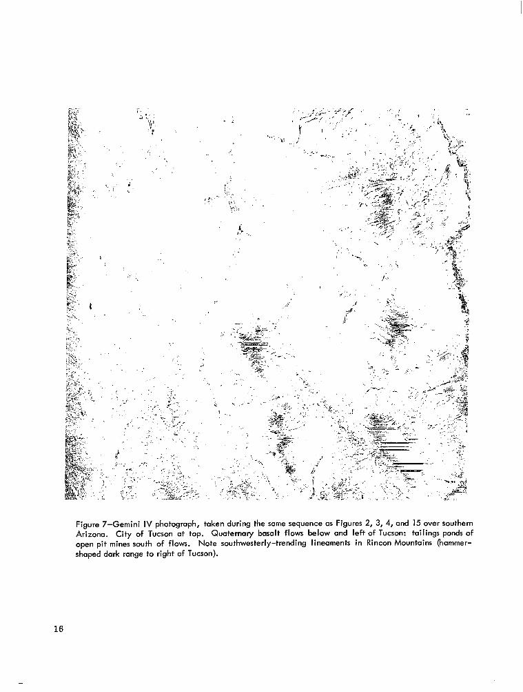
Figure 7-Gemini IV photograph, taken during the same sequence as Figures 2, 3, 4, and 15 over southern Arizona. Quaternary basalt flows below and left of Tucson: tailings ponds of open pit mines south of flows. Note southwesterly-trending lineaments in Rincon Mountains (hammer- shaped dark range to right of Tucson).
City of Tucson at top.
16

Figure 8-Viking 12 photograph, taken in 1955 from 140 miles altitude, with Kodak Hi-Speed Infrared f i lm. View to the southwest; Gul f of California at left, Pacific Ocean on Horizon. Rincon Mountains (Figure 9) indicated by arrow; note that the lineaments visible in Figure 7 do not show up here. Most of the terrain features shown in Figures 2, 3, 4, and 15 are visible here.
17

Atmospheric scattering, with consequent color distortion and contrast attenuation, becomes’ severe in oblique photographs, because the thickness of atmosphere which the light must penetrate, like the slant range, is also inversely proportional to the cosine of the tilt. As would be expected, the far portions of hyperaltitudc! oblique photographs with standard color film are usually exces- sively blue, even with the use of minus blue filters.
Target Acquisition
Although it has been proven that astronauts with good eyesight can see remarkably small ob- jects on the ground from orbit, target acquisition is still a problem when photography of individual points is desired. This was also demonstrated by the visual acuity test performed on Gemini V and VII (Duntley, 1966); the astronauts were able to see the majority of targets, but had difficulty in finding them first. This problem has been overcome by computer techniques developed by the Manned Spacecraft Center,* by which detailed instructions on time of exposure and spacecraft orientation for photographing any object on the ground or in space can be sent to the astronauts in flight. The application of this technique, however, requires that the sites to be photographed must be picked well in advance and the necessary preliminary data computed.
Environmental Degradation of Film
No gross deterioration of film has been noticed on terrain photography taken during Gemini or Mercury flights, although in some of these flights involving extravehicular activity the cameras have been exposed directly to space fo r some time. However, on longer missions the space en- vironment may have substantial effects; in particular, extremes of temperature, low pressure, and radiation must be taken into account. Radiation in particular may cause a decrease in resolution (Harvey, 1965). Although fairly long flight t imes in space would be needed to fog film by natural radiation (excluding flares), it has been discovered that radioactive sources such as radiolumines- cent dials and thorium-containing alloys in the spacecraft itself may present a problem (NASA SP-88, 1965).
SPECIFIC USES OF ORBITAL PHOTOGRAPHY
Although systematic photography of the earth from space for geologic purposes has only begun, specific geologic uses of this photography are already apparent, and will be discussed under the following broad categories.
Regional Geologic Mapping
The uniquely small scale of hyperaltitude photographs makes them especially valuable, in principle, for the preparation or revision of geologic maps of comparable scale, i.e., 1:1,000,000
*R. D. Mercer, personal communication.
18

o r smaller. (The preparation of tectonic maps is included in this general category.) Map revision using orbital photographs undoubtedly will be done first, because the extension of geologic units from well mapped a reas into poorly mapped areas will require relatively little field-checking.
The Pinacate volcanic field is exceptionally well-delineated on Figure 11. However, on the 1960 Geologic Map of Mexico, it is not shown at all, although the field is well known to Mexican geologists. The immediate reason for this is that in this particular map, Cenozoic volcanics and alluvium derived from them are a single unit. With the use of the Gemini photograph, however, the Quaternary alluvium/Quaternary volcanic contact can be accurately and quickly drawn.
The Sierra Carizarilla (Figure 10) in Chihuahua also are not shown on this map in their en- tirety. Furthermore, this large volcanic field is labeled as Middle Cenozoic, but is almost cer- tainly Quaternary. In addition to the slight degree of dissection apparent on the photograph, the field is clearly related to the few isolated volcanoes j u s t north of the border which are shown as Quaternary on the Geologic Map of New Mexico (Dane and Bachman, 1964).
In some areas, geologic mapping from orbital photographs can be done at scales considerably larger than those of the original picture. This is demonstrated in Figure 11. Although the original scale of the picture is approximately 1:2,500,000, most of the geologic detail shown on the 1:375,000 Geologic Map of Yuma County (Wilson, 1960) can be delineated.
Monitoring of Variable Properties
Although geologists are accustomed to thinking in extremely long time spans, there are never- theless a number of geologically important phenomena which take place in months, days, o r even minutes, and which could be studied profitably by orbital photography. The color and distribution of the turbid effluent from large r ivers has been photographed on a number of Gemini missions, first essentially by accident and then by design. In Figure 2 the effluent pattern over several thousand square miles is distinct. Related to this application is the monitoring of changes in shallow-water bottom topography. This is routinely done in the United States by aerial photography after major hurricanes, but there is no comparable effort for less-developed coastal regions nor for noncatastrophic bottom changes. The study of Figure 4 by Gettys (1965) demonstrates the potential feasibility of at least qualitative bottom mapping by orbital photography.
The ability to photograph entire drainage basins very rapidly should find considerable geologic application. Fo r example, r ivers such as the Mississippi can in flood season make major changes in their courses by cutting off meanders, eroding existing ones, and depositing new bars. These changes are of course now monitored by aerial photography in many countries, but the speed and global span of satellite coverage would permit extension of this service to less-developed regions such as the Amazon basin.
Topographic changes produced by major earthquakes are also routinely mapped by aerial photography. However, many earthquakes in remote areas such as central Asia cannot be studied this way for obvious reasons; satellite coverage of these would be of considerable scientific interest
19
I

I I I 1 IIIIlIIIIIIll111111ll I II I 1lll11 Ill I I II
Figure 9-Gemini IV photograph taken over Chad, North Africa, looking to northwest. Tibest i Mts. at left center; prominent volcano i s Emi Koussi. Note arcuate ridges in center, believed to be sand dunes and fractures i n sandstone plateau. Circular structure in center of picture i s a series of concentric sand- stone ridges about 5 miles i n diameter; i t s origin i s unknown, but a laccolith i s suspected.
20

Figure 10-Gemini IV photograph, taken in same series as Figure 7. Area shown i s northern Chihauhua, Mexico, and southem New Mexico. Note gradation from block-faulted mountains of the Basin and Range Province at upper left to folded structure of extension of the Sierra Madre Oriental at lower right. Sierra Carizarilla, previously unmapped Quaternary volcanic field, i s dark area at right center.
21

. ,
Figure 1 1-Gemini IV photograph, taken about 10 seconds after Figure 4, covering part of northwestern Sonora and Southwestern Arizona. Mexico - United States border cuts photo diogonally i n upper right corner. In Arizona, linear ranges are underlain by Mesozoic metamorphic rocks, intruded by Mesozoic granites and overlain in places by Quaternary basalts. Sierra del Pinacate, a Quaternary volcanic field, i n center of photo.
22

and very possibly of immediate value to the countries affected. R. W. Underwood has identified, on pictures taken by T. Stafford and E. Cernan during the Gemini 9 mission, a landslide which oc- curred during the disastrous Peruvian earthquake of 1962, and a large ephemeral lake in the Andes caused by a much earlier landslide.
Related to this application would be periodic surveillance of active or potentially active vol- canoes by orbital photography. F o r maximum effectiveness, photography should of course be teamed with devices such as infrared scanners, whose usefulness in volcano surveys has been demonstrated by Fischer (Fischer, et al. , 1964), and possibly with automatic seismographs, tilt- meters, and thermometers read out on command by the camera-carrying satellite. Erupting vol- canoes could be photographed to provide a continuous check on the extent of damage caused by air- borne ash, gases, and earthquakes. Such a volcano watch might be only one function of what could be called a geophysical hazards satellite, which, equipped with nonvisual sensors and commanding a network of ground monitoring stations, could provide warning of earthquakes, floods, and ava- lanches, in addition to volcanic eruptions. An added benefit would be the early detection of other natural hazards such as forest fires, crop diseases, locust plagues, and forest diseases.
Numerous other geological phenomena could in principle be studied by orbital photography including seasonal changes in playa lakes,* sand dune movement, snow accumulation, and glacial growth.
Geological Education
Air photos have been used effectively for many years in geology textbooks, and similar use of photography of the earth from space is beginning. The chief advantage of orbital photography in this application is that it becomes possible to show actual pictures of very large features rather than the stylized diagrams currently used. A good example of this is Figure 12, which shows a large area of folded mountains and a major (scissors) fault at a glance. In Figure 13, a striking example of incipient stream piracy is apparent. Comparison of Figures 10 and 17 illustrates at least the major differences between block-faulted and folded mountains and could serve as a useful background for a more detailed explanation.
Additional advantages of orbital photography for educational purposes a r e their objectivity and geometric fidelity (subject to camera orientation and scale). The objectivity of photographs should be especially valuable in the teaching of, for example, regional tectonics. Even the most skillfully constructed sketch maps of major geologic provinces are at least partly subjective; in addition to possible e r r o r s of interpretation, sketch maps have the disadvantage of omitting features of pos- sible importance, such as Cenozoic volcanic fields, in order to focus attention on others. The geometric fidelity of orbital photography may prevent unconscious misconceptions of relative size and vertical scale to creep into the student's mind. For example, to show the known cryptovolcanic and impact structures of the United States on a small map (Shoemaker, Hackman, and Eggleton, 1962), it is necessary to represent each one by a dot or circle whose size i s an appreciable fraction
*Personal communication with J. T. Neal.
23

Ill IllIIl1lll11llll1 II 1111ll111l1lllll
Figure 12-Gemini V photograph over southeastern Iran. City of Kerman i s in cultivated valley at left. Folds in sedimentary rock at center are truncated by major fault at right. Linear features at lower right are ridges in the Dasht-i-Lut, a salt desert. Photograph was taken early i n the morning, accentuating re I ie f .
24

Figure 13-Gemini VI1 photograph showing southern part of the Arabian peninsula, looking to the south- east over the Hadramaut Plateau and the Arabian Sea. Dendritic valley in 'foreground i s the Wadi Hadramaut. Note intersecting stream pattern at center, interpreted as structurally-control led stream piracy.
25

l11111111111111111111lll I I I1 lllll I1 IIIIII
of the apparent width of the continent; the casual viewer might unknowingly get the impression of a much higher density of such structures than actually exists. However, pictures from orbital alti- tude such as Figure 9 provide a true concept of their actual rari ty and small relative size. Another misconception which may be avoided by the use of orbital photographs is the relative thickness of continents; a student who has seen Figure 8 will probably not ca r ry away the image of thick, iceberg-like continental blocks pictured in many textbooks.
THEORETICAL APPLICATIONS OF ORBITAL PHOTOGRAPHY
The specific uses of orbital photography jus t discussed will find application to a great variety of geologic problems. A few of the more promising ones will be discussed. It is hardly necessary to mention that the photograph interpretations presented are preliminary; much more definitive work can be expected by specialists familiar with the areas covered.
Continental Dyi f t
From its position in the limbo of discarded theories 15 years ago, continental drift has sprung back into the spotlight of attention because of recent studies in paleomagnetism and other fields. It is, in fact, again one of the major issues in geology, as evidenced by the fact that i t s solution is one of the chief objectives of the Upper Mantle Project. Orbital photography may be applied to the problem of continental drift in several ways.
Probably the most immediate of these ways is by improving our knowledge of the Precambrian structure of continental areas supposed to have been in contact. With D. P. Gold, the writer is using the Gemini 5 pictures of southwestern Africa (Figure 14) to study the regional structure. When pictures of the corresponding areas of South America become available, a comparison of these with Africa can be made, as Brock (1956) has done on the basis of conventional maps. If post-Lipalian drift has occurred, we should expect considerable correspondence in the regional Precambrian structure on opposite sides of the Atlantic.
The South Atlantic is of course the most promising a rea for a study of continental drift; i f the theory cannot be proved here, it is not likely to be proved anywhere. However, corresponding studies should be made of the Precambrian of southern India, Australia, and southeastern Africa. An additional area which might be of interest is the Red Sea and adjoining crystalline highlands in Africa and the Arabian Peninsula; if incipient continental separation and rotation is occurring here, systematic relations between the regional fracture patterns of the two a reas might be found on or- bital photographs (Figure 16). The Gemini photographs were actually used by Lowman (1967)* to study the supposed connection between the ranges of the eastern Arabian Peninsula and West Pakistan. He found significant differences in structure and lithology, as well as previously unclear structural trends, which indicate that there is no tectonic connection between the two areas. This tends to weaken theories of continental drift in the Arabian Sea area.
*Paper presented at the Symposium on Continental Drift, sponsored by UNESCO, Montevideo, Uruguay, October 1967.
26

. ,(.
Figure 14-Gemini V photograph of South-West Africa, vicinity of Walvis Bay (left center). Linear features in bottom half of picture are sand dunes, bounded on north by Kuiseb River. Area north of Kuiseb River i s underlain by Precambrian mefasediments of the Khomas and Hakos series, intruded by Precambrian granites and by Karoo dolerites.
27

I Ill I1 I 11ll1111111l11 I I1 Ill IIIII
Stvucture of Rift Valleys
Because it is part of one of the biggest tectonic structures on earth, the African Rift Valley has been an area of prime interest to the Upper Mantle Project. For this reason, it has been an objective of the S-5 Synoptic Terrain Photography experiment on several Gemini flights (Lowman, 1966), and will also be photographed during Apollo missions. The photographs thus obtained should be of value in studying the overall structure of the African Rift Valley and its supposed counter- part, the Gulf of California. New light on the relation of Cenozoic vulcanism to the rift valleys may result from this study. In North America, it is hoped to attack the problem of how the dominantly normal movement of the rift-bounding faults in Africa and the mid-ocean ridges changes into the dominantly lateral movement of the San Andreas system. Wilson's (1965) explanation might be tested i f a junction between his proposed 'Yransform faults" and a graben can be located on orbital photographs of land areas.
Extent and Oyigin of Tvanscuvvent Faulting
As recently pointed out by Allen (1965), active transcurrent (strike-slip) faults seem to be much more widespread than once thought. The San Andreas fault system, for example, has been demonstrated to be only one of a system of circum-Pacific faults whose other members a r e in the Philippines, Taiwan, New Zealand, and Chile. An even more interesting transcurrent fault system, discovered by oceanic magnetic surveys (Vacquier, 1962), includes s e v e r d east-west trending transcurrent faults in the eastern Pacific. These faults may extend into North America for several hundred kilometers (Zietz, 1965) and all the way across northern South America (Fuller, 1964).
The main reason that these major faults were not better known before this appears to be simply that geologic mapping of the areas in question is not very advanced (Allen, 1965). Allen points out that physiographic cr i ter ia a r e very useful in the study of active transcurrent faults, because they must straighten rapidly with continuing displacement; he suggests, in fact, that all exceptionally straight regional fractures should be suspected of being transcurrent until proved otherwise.
Orbital photography is already being applied to the study of such faults. The Agua Blanca fault, for example, was not discovered until 1956 by Allen, Silver, and Stehli (Allen, et al., 1960), and is exceptionally well-displayed on one of the first Gemini photographs taken specifically for geologic purposes (Figure 15). It is apparent, from this photograph, that the Agua Blanca fault is probably one of a ser ies of northwesterly-trending faults, which may have some systematic re- lation to a less prominent southwesterly-trending set of fractures.
Allen's admonition to examine all major straight fractures for evidence of transcurrent move- ment can easily be applied to Figure 1 2 (Iran). The major fault bounding the Dasht-i-lut can be seen to show primarily vertical movement (possibly rotational) rather than lateral movement.
The question of whether the major transcurrent faults of the eastern Pacific c ros s the conti- nent may be susceptible to attack by orbital photography. The geologic .evidence for such extension must be relatively subtle in central North America (Gilliland, 1962); there is no obvious alignment
28

I
Figure 15-Gemini IV photograph, showing northern Baja California, Mexico; Bahia de Todos Santos and city of Ensenada at upper left corner, (note ietty projecting southward); Sierra Juarez and Sierra de Son Pedro Martir at right;and the Agua Blanca fault zone at lower left,paraIlel to edge of spacecraft window. Area covered about 65 miles east-west distance at top of photo.
29

of intrusives, structures, or earthquake epicenters. However, hyperaltitude photographs of this area, when available, may show previously Unnoticed lineaments, by virtue of their great coverage. Attempts will be made to obtain photographs of the Neovolcanic Plateau of southern Mexico, which may represent the continentztl extension of the Clarion fracture zone (Maldonado-Koerdell, 1966).
Existence of a Global Tectonic Pattern
Hills (1963) points out that we do not know at present if there is "a global pattern to which con- tinental and oceanic megalineaments conform," o r if the structure of each major region is essen- tially unrelated to that of other major regions. This reflects the rather surprising fact that we know more of the overall tectonic structure of the moon than we do of the earth; see, for example, maps by Strom (1965) and Fielder (1961). Some geologists, such as Badgley (1965), feel that there are two major directions to world structural trends, and that divergences from these trends are the result of continental drift and attendent rotation.
Study of this problem is hampered by a number of factors, the most obvious being, again, the relatively poor state of world geologic mapping. Orbital photography will clearly be applicable directly to this difficulty. An additional benefit of this photography may be the ability to distinguish truly continent-wide structural patterns from those which are essentially local. Figure 9 illus- trates this possibility; the arcuate fracture/dune pattern surrounding the Tibesti Mountains, not shown on existing maps, is clearly related to their uplift rather than to global stresses.
Role of Major Impacts in Crmstal Evolution
Recent investigations of shock metamorphism, stimulated partly by the search of the Canadian Shield for impact structures by the Dominion Observatory (Beals, et al., 1963), have revealed the presence of a large number of ancient impact craters o r their roots. This research, together with growing evidence of the impact origin of large lunar craters, suggests that major impacts may have played a surprisingly large role in terrestrial geologic history. Hudson Bay, for example, is now seriously considered to be the possible site of a former crater comparable to Mare Crisium in size (Shoemaker, 1966). Dietz's discovery of shatter cones at Sudbury, Ontario (Dietz, 1961) and his prediction of their discovery around the Vredefort Dome by Hargreaves (1961), though controversial, have given further impetus to study of the geologic role of impact. Should such major structures be proven of impact origin, it would give a totally new dimension to the concept of uniformitarianism.
Orbital photography can be brought to bear on this problem in several ways. The first of these is simply a search for unmapped circular structures in Precambrian areas-essentially an extension of the search of air photos conducted by the Dominion Observatory. At least one circular structure has been found on Gemini photographs (Figure 9), although it is probably of igneous origin. Another application of orbital photography lies in study of the relations between suspected impact structures and the regional structure. Geologists such as Bucher (1965) who advocate an internal origin for these structures draw heavily on such relations, which can now be studied from
30

Figure 16-Gemini XI1 view to south over the Red Sea, Gulf of Suez (lower left), and Sinai Peninsula. Note fracture patterns in Precambrian massifs of Sinai and Egypt (dark units). Lighter-toned rocks with dendritic drainage (foreground) are plateaus capped chiefly with Eocene limestones.
31

Figure 17-Gemini XI1 view to east over the Persian Gulf (lower right) and Gulf of Oman. Iran at left, Muscat and Oman at right. Anticlines of the Zagros Mountains, pierced by salt plugs (dark circular areas) shown at lower left. Note sharp discontinuity opposite Strait of Hormuz, center, which may represent a zone of strike-slip faulting. Dark rock of the Oman range, right, i s chiefly basalt and associated rocks of the ophiolite suite.
32
I

a new vantage point. Finally, orbital mapping should reveal previously unknown recent c r a t e r s in areas like South America, for which only two impact c r a t e r s are now known (Sanchez and Cassidy, 1966).
Evolution of Topography in Arid Regions
Most orbital photography using returned film to date has been taken over low latitudes because of orbital restrictions. Because such latitudes include many of the world's great deserts, the study of arid region geomorphology should be an early beneficiary of orbital photography. Probably the most obvious application lies in the study of sand dune evolution. Many aspects of this process are not at all clear, as pointed out by Smith (1963). Even the existing Gemini photographs, however, (Figures 5 and 14) should be useful in the study of sand dunes because they provide regional cover- age, contrasted with the local coverage of aircraft photos previously used. This coverage permits accurate delineation of the distribution and interrelation of various dune types and shows their re- lation to surrounding topography.
The origin of pediments can also be studied by orbital photography. In Figure 10, for example, several conspicuous pediments can be seen. The availability of color coverage of large arid regions should permit study of entire zones of pedimentation and its relation to the underlying structure and lithology.
The study of the soils of arid regions is uniquely suited to orbital photography. Because there is relatively little agriculture in these areas, there is surprisingly little map coverage of desert soils. This may shortly prove a serious handicap to the increasing use of arid regions, but one which orbital photography promises to alleviate. An interesting research application is being made of Gemini photographs by T. R. Walker*. Walker has discovered new evidence supporting the once-abandoned classic view that red sediments were formed chiefly in arid regions, and is using Gemini pictures to map the distribution of Recent red sediments and to plan further field work.
SUMMARY AND CONCLUSIONS It is clear that photography of the earth from orbiting spacecraft offers geologists a powerful
new tool. This review has barely touched on the general applications of orbital photography. Fo r example, there has been little mention of its use in the utilization of natural resources (partly, of course, because geologic mapping is fundamental to such utilization). However, Fischer (1966) has pointed out that the use of nonrenewable resources is accelerating at such a rate that natural re- source surveys from space will shortly become a necessity, rather than a scientific luxury. As suggested by Lowman and Chang (1965), the less-developed countries will probably be the first to benefit from applied orbital photography.
It should be stressed that the potential capabilities of earth-orbiting spacecraft will be partly wasted if photography is used alone. A variety of sensors, including radar, infrared scanners,
'Persona l communication.
33

magnetometers, and other nonimaging devices should be carried. Furthermore, the need for con- ventional aerial surveys will by no means be eliminated; guided to areas of special interest by small-scale orbital coverage, their usefulness should in fact be greatly increased. The need for field checks will also remain. However, the immense coverage per photograph typical of hyper- altitude photography suggests that direct ground surveys using orbital photographs as air photos are used will be inefficient; instead, conventional air photos or visual aerial reconnaissance will probably take the place of field checking. The writer, for example, found a two-hour flight at 2500 feet invaluable in studying the area covered by Figure 10.
Plans are in preparation for more advanced photographic missions. The feasibility and general usefulness of orbital photography have been demonstrated by the experiments performed by Mer- cury and Gemini astronauts. However, these have been only "piggyback" operations using small hand-held cameras; and the low-inclination orbits so f a r achieved have missed many of the most interesting geological areas. Pictures and nonvisual data obtained by high-inclination missions specifically flown for this purpose should be incomparably more valuable than those presented here.
This paper is based upon the efforts of many people. The pictures which illustrate it could of course not have been taken without the persistence and skill of the astronauts who flew the various Gemini missions. In addition, credit should be given to personnel of the Manned Spacecraft Center who supported the terrain photography experiment, in particular R. D. Mercer, R. W. Underwood, and T. F. Brahm. I am also grateful to W. A. Fischer of the U. S. Geological Survey for his re- view of the manuscript, to A. Woloshin, also of the U. s. Geological Survey, for information on the Sayan fault, and to Ing. Guillermo P. Salas, of the Geologic Institute, National University of Mexico, for geologic maps and advice.
Goddard Space Flight Center National Aeronautics and %ace Administration
Greenbelt, Maryland, April 5, 1967 188-45-01-01-51
REFERENCES
1. Allen, C. R., "Transcurrent Faults in Continental Areas, A Symposium on Continental Drift," Phil. Trans. Roy. SOC. 258:82-89, 1965.
2. Allen, C. R., Silver, L. T., and Stehli, F. G., "Agua Blanca Fault-A Major Transverse Struc- ture of Northern Baja California, Mexico," Geol. SOC. Am. Bull. 71:457-482, 1960.
3. Badgley, P. C., "Scientific Experiments for Manned Orbital Flight," Third Goddard Memorial Symposium, American Astronautical Society, Washington, D. C., March 18-19, 1965.
34
4. Badgley, P. C., "Structural and Tectonic Principles," New York: Harper & Row, 1965.
5. Beals, C. S., "Fossil Meteorite Craters," Scientific American, July 1958.
6. Brock, B. B., 'Structural Mosaics and Related Concepts," Trans. Geol. SOC. South Africa 59~149-197, 1956.
7. Bucher, W. H., "The Largest So-called Meteorite Scars in Three Continents as Demonstrably Tied to Major Terrestr ia l Structures," Geological Problems in Lunar Research, edited by H. E. Whipple, Annals of the New York Academy of Sciences, 123, 2 , 897-903, 1965.
8. Colwell, R. N., "Some Practical Applications of Multiband Spectral Reconnaissance," American Scientist 49( 1) : 9- 36, March 196 1.
9. Dane, C. H., and Bachman, G. O., Geologic Map of New Mexico (Scale 1:500,000), U. S. Geo- logical Survey, Washington, D. C., 1965.
10. Dietz, R. S., T r e d e f o r t Ring Structure: Meteorite Impact Scar?," Jour. Geol. No. 5, 69-499- 516, 1961.
11. Duntley, S. Q., Austin, R. W., Taylor, J. H., and Harris, J. L., "Experiment S-8/D-13, Visual Acuity and Astronaut Visibility, '' Gemini Midprogram Conference, NASA Special Publication SP-121, February 1966.
12. Fielder, G., "Structure of the Moon's Surface," New York: Pergamon Press, 1962.
13. Fischer, W. A., "Color Aerial Photography in Photogeologic Interpretation," Photogrammetric Engineering 24(14):545-549, September 1958.
14. Fischer, W. A., Moxham, R. H., et al., "Infrared Survey of Hawaiian Volcanoes," Science, 146, 3645, 733-742, November 6, 1964.
15. French, B. M., "Conference on Shock Metamorphism, Science August 19, 1966.
16. Fuller, M. D., "Expression of E-W Fractures in Magnetic Surveys in Parts of the U.S. A., Geophysics XXIX, No. 4, 602-622, August 1964.
17. Gilliland, W. N., ?Fossible Continental Continuation of the Mendocino Fracture Zone," Science 137~685-686, August 31, 1962.
18. Hargreaves, R. B., "Shatter Cones in the Rocks of the Vredefort Ring," Geol. soc. South Africa Trans. 64:147-153, 1961.
19. Harvey, D. I., "Environmental Effect on Photographic Characteristics,f' edited by H. J. Hall and H. K. Howell, Itek Corporation, Lexington, Massachusetts, 1965.
20. Harvey, D. I., and Myskowski, E. P., T h y s i c s of High Altitude Photography," Photographic Considerations f o r Aerospace, edited by H. J. Hall and H. K. Howell, Itek Corporation, Lexington, Massachusetts, 1965.
21. Hills, E. S., *'Elements of Structural Geology," New York: John Wiley & Sons, Inc., 1963.
22. Hope, J. R., ?'Path of Heavy Rainfall Photographed from Space,'' Bull. Am. Meteorological SOC. 47:371-373, 1966.
35

23. Lowman, P. D., Jr., "A Review of Photography of the Earth from Sounding Rockets and Satel- lites," NASA Technical Note TN D-1868, December 1964.
24. Lowman, P. D., Jr., "Experiment S-5, Synoptic Terrain Photography," Gemini Midprogram Conference, NASA Special Publication SP-121, February 1966.
25. Lowman, P. D., Jr., "Lunar Impact Craters," Encyclopedia of the Earth Sciences, 2, edited by R. W. Fairbridge, New York: Columbia University Press, (in press).
26. Lowman, P. D., Jr., and Chang, T. L., "Hyperaltitude Photography and Its Applications, Scien- tific Experiments for Manned Orbital Flight," Third Goddard Memorial Symposium, March 18-19, 1965, edited by P. C. Badgley, American Astronautical Society, Washington, D. C., 1965.
27. Lowman, P. D., Jr., McDivitt, J. A., and White, E. H., "Terrain Photography on the Gemini IV Mission: Preliminary Report,'' NASA Technical Note D-3982, June 1967.
28. Maldonado-Koerdell, M. , "Report of the Mexican Upper Mantle Committee,'' International Upper Mantle Project, Report No. 3, Los Angeles, 1966.
29. Mazurowski, M. J., Silvestro, F. B., and Rinaldo, J. D., "A Study of Photographic Contrast Attenuation by the Atmosphere," ASD-TDR-63-541, A i r Force Systems Command, Wright- Patterson Air Force Base, Ohio, September 1963.
30. Meeker, L. C., "Observations in Space,'' address to the Institute of Air and Space Law, McGill University, Department of State Press Release No. 191, April 13, 1963.
31. Merifield, P. M., "Photo Interpretation and Photogrammetry of Hyperaltitude Photography," Contract No. NAS 5-3390, LR 17666, Lockheed-California Co., February 1964.
32. Merifield, P. M., and Rammelkamp, J., "Terrain in Tiros Pictures," Report No. 3, Contract No. NAS 5-3390, LR 17848, Lockheed-California Co., June 1964.
33. Miller, V. C., "Photogeology,r' New York: McGraw-Hill, 1961.
34. Morrison, A., and Chown, M. C., lThotography of the Western Sahara Desert from the Mer-
35.
36.
37.
38.
39.
36
cury MA-4 Spacecraft," NASA Contractor Report CR-126, December 1964.
Nagler, K. M., and Soules, S. D., "Cloud Photography from the Gemini 4 Spacecraft,'' B U Z Z . Am. Meteorological Soc. 46:522-527, 1965.
Rochlin, R. S., "Observation Satellites fo r Arms Control Inspection,'' J . Arms Control 1(3):224-247, July 1963.
Sanchez, J. , and Cassidy, W., "A Previously Undescribed Meteorite Crater in Chile,'' paper presented at Conference on Shock Metamorphism of Natural Materials, GSFC, Greenbelt, Md., April 14-16, 1966.
Schirra, W. M. , Jr., Pilot's flight report, results of the third United States manned orbital space flight, NASA Special Publication SP-12, U. S. Government Printing Office, Washington, D. C., 319-334, October 3, 1962.
Shoemaker, E. M., Hackman, R. J., and Eggleton, R. W., "Interplanetary Correlation of Geo- logic Time," Advances in the Astronautical Sciences, 8, Plenum Press, New York, N.Y., 1962.

40. Singer, S. F., and Popham, R. W., Won-meteorological Observations from Weather Satellites," Astronautics and Aerospace Engineering 1(3):89-92, April 1963.
41. Smith, H. T. U., "Eolian Geomorphology, Wind Direction, and Climatic Change in North Africa," AFCRL-63-443, Geophysics Research Directorate, Air Force Cambridge Research Labora- tories, Bedford, Massachusetts, 48 p., 1963.
42. Strom, R. G., "Analysis of Lunar Lineaments," (Abstract), Trans. Am. Geophys. Un., 46, 1, 138, 1965.
43. Wilson, E. D., Geologic Map of Yuma County, Arizona (Scale 1:375,000), Arizona Bureau of Mines, University of Arizona, Tucson, Arizona, 1960.
44. Wilson, J. T., "A New Class of Faults and Their Bearing on Continental Drift," Nature 4995, 343-347, July 24, 1965.
NASA-Langley, 1967 - 13 37

‘IThe aeronautical and space activities of the United States shall be conducted so cu to contribute . . . to the expansion of human Knowl- edge of phenomena in the atmosphere and space. The Admihistration shall provide for the widest practicable and appropriate dissemination of information concerning its activities and the results thereof .”
-NATIONAL AERONAUTICS AND SPACE ACT OF 1958
NASA SCIENTIFIC AND TECHNICAL PUBLICATIONS
TECHNICAL REPORTS: Scientific and technical information considered important, complete, and a lasting contribution to existing knowldge.
TECHNICAL NOTES: Information less broad in scope but nevertheless of importance as a contribution to existing knowledge.
TECHNICAL MEMORANDUMS: Information receiving limited distribu- tion because of preliminary data, security classification, or other reasons.
CONTRACTOR REPORTS: Scientific and technical information generated under a NASA contract or grant and considered an important contribution to existing knowledge.
TECHNICAL TRANSLATIONS: Information published in a foreign language considered to merit NASA distribution in English.
SPECIAL PUBLICATIONS: Information derived from or of value to NASA activities. Publications include conference proceedings, monographs, data compilations, handbooks, sourcebooks, and special bibliographies.
TECHNOLOGY UTILIZATION PUBLICATIONS: Information on tech- nology used by NASA that may be of particular interest in commercial and other non-aerospace applications. Publications include Tech Briefs, Technology Utilization Reports and Notes, and Technology Surveys.
Details on the availability of these publications may be obtained from:
SCIENTIFIC AND TECHNICAL INFORMATION DIVISION
NATIONAL AERONAUTICS AND SPACE ADMINISTRATION
Washington, D.C. PO546