Geologic and Aeromagnetic Maps of the Fossil Ridge … · tonalite at Cumberland Pass (unit TKt)...
45
Geologic and Aeromagnetic Maps of the Fossil Ridge Area and Vicinity, Gunnison County, Colorado By Ed DeWitt, 1 R.S. Zech, 1 C.G. Chase, 2 R.E. Zartman, 3 R.P. Kucks, 1 Bruce Bartleson, 4 G.C. Rosenlund, 5 and Drummond Earley, III 6 Pamphlet Geologic Investigations Series I-2738 2002 1 U.S. Geological Survey, Denver Federal Center, Denver, CO 80225 2 Department of Geosciences, University of Arizona, Tucson, AZ 85719 3 U.S. Geological Survey, Denver Federal Center, Denver, CO 80225 Present address: Department of Geological Sciences, University of Cape Town, Cape Town, South Africa 4 Department of Geology, Western State College, Gunnison, CO 81230 5 GRG Corporation, 4175 Harlan St., Wheat Ridge, CO 80033 6 Daniel B. Stephens and Associates, 6020 Academy NE, Suite 100, Albuquerque, NM 87109 U.S. Department of the Interior U.S. Geological Survey
Transcript of Geologic and Aeromagnetic Maps of the Fossil Ridge … · tonalite at Cumberland Pass (unit TKt)...

Geologic and Aeromagnetic Maps of the Fossil Ridge Area and Vicinity, Gunnison County, Colorado
By Ed DeWitt,1 R.S. Zech,1 C.G. Chase,2 R.E. Zartman,3 R.P. Kucks,1
Bruce Bartleson,4 G.C. Rosenlund,5 and Drummond Earley, III6
Pamphlet Geologic Investigations Series I-2738
2002
1 U.S. Geological Survey, Denver Federal Center, Denver, CO 80225 2 Department of Geosciences, University of Arizona, Tucson, AZ 85719 3 U.S. Geological Survey, Denver Federal Center, Denver, CO 80225
Present address: Department of Geological Sciences, University of Cape Town, Cape Town, South Africa
4 Department of Geology, Western State College, Gunnison, CO 81230 5 GRG Corporation, 4175 Harlan St., Wheat Ridge, CO 80033 6 Daniel B. Stephens and Associates, 6020 Academy NE, Suite 100,
Albuquerque, NM 87109
U.S. Department of the Interior U.S. Geological Survey

Contents
Description of Map Units ............................................................................................................ 1Aeromagnetic Survey .................................................................................................................. 36
Tertiary and Cretaceous Igneous Rocks ....................................................................... 36Proterozoic Igneous Rocks............................................................................................... 37Proterozoic Metamorphic Rocks ..................................................................................... 38
Mineral Deposits ........................................................................................................................... 38Gold placer Mineralized Districts .................................................................................... 38Base- and Precious-Metal Districts containing Deposits of Tertiary toCretaceous Age and Older(?) ........................................................................................... 39High-Calcium Limestone District ..................................................................................... 39Precious-Metal District containing Early Proterozoic Veins inBasement Rocks................................................................................................................. 40Pegmatite District ............................................................................................................... 40
Acknowledgments ....................................................................................................................... 40References Cited .......................................................................................................................... 40
Figures
1. Summary geochemical diagrams for rhyolite (unit Tr) and the porphyry of Green Mountain (unit Tgm)............................................................................. 2
2. Summary geochemical diagrams for rhyolite (unit Tr) from the Chicago Park area ................................................................................................................. 6
3. Summary geochemical diagrams for rhyolite (unit Tr) from the Napolean Pass area and the Tincup area......................................................................... 7
4. Summary geochemical diagrams for Fossil Ridge Latite (unit Kf) and tonalite at Cumberland Pass (unit TKt)............................................................................... 10
5. 40Ar/39Ar release spectra for hornblende from Fossil Ridge Latite (unit Kf) ............... 136. Summary geochemical diagrams for granite of Taylor River (unit Yt) ......................... 157. Summary geochemical diagrams for Crystal Creek Gabbro (unit Xc), gabbro
dikes (unit YXgb), and gabbroic rocks in the Almont area.............................................. 188. Summary geochemical diagrams for Fairview Peak Granodiorite (unit Xf)
and granodiorite in the Almont area................................................................................... 219. Summary geochemical diagrams for the Henry Mountain Granite (unit Xh)
and the Willow Monzonite (unit Xw) .................................................................................. 2610. Summary geochemical diagrams for granodiorite of Broncho Mountain
(unit Xb) and the Roosevelt Granite (unit Xr)..................................................................... 2911. Summary geochemical diagrams for metagabbro and gabbro near Ohio
(unit Xgb), magic metavolcanic rocks near Ohio (Xmv), and maficmetavolcanic rocks south of Ohio, near the Revenue mine........................................... 33
III

Tables
1. Major- and minor-element chemistry of Oligocene rhyolite (unit Tr) ........................... 32. Major- and minor-element chemistry of Oligocene porphyry near
Chicago Park (unit Tr) ........................................................................................................... 43. Major- and minor-element chemistry of Oligocene quartz porphyry near
Napolean Pass (unit Tr) ........................................................................................................ 84. Fission-track data for Late Cretaceous and Oligocene igneous rocks ........................ 85. Major- and minor-element chemistry of Oligocene porphyry of
Green Mountain (unit Tgm) .................................................................................................. 96. Major- and minor-element chemistry of Tertiary-Cretaceous tonalite at
Cumberland Pass (unit TKt) and Fossil Ridge Latite (unit Kf) ......................................... 117. 40Ar/39Ar analytical data for hornblende from sill and dike of Fossil Ridge Latite...... 128. Major- and minor-element chemistry of the Middle Proterozoic granite of
Taylor River (unit Yt) .............................................................................................................. 169. K-Ar analytical data from Middle Proterozoic Taylor River Granite (unit Yt)............... 18
10. Major- and minor-element chemistry of Early to Middle Proterozoic gabbroicrocks (units YXgb, Xc, and Xgb?) ........................................................................................ 19
11. Major- and minor-element chemistry of Early Proterozoic Fairview PeakGranodiorite (unit Xf) and granodiorite at Almont............................................................ 22
12. Major- and minor-element chemistry of Early Proterozoic Henry MountainGranite (unit Xh) ..................................................................................................................... 25
13. Major- and minor-element chemistry of Early Proterozoic Willow Monzonite(unit Xw) .................................................................................................................................. 28
14. Major- and minor-element chemistry of Early Proterozoic granodiorite ofBroncho Mountain (unit Xb) and Roosevelt Granite (unit Xr)......................................... 30
15. Major- and minor-element chemistry of Early Proterozoic metagabbro(unit Xgb) and mafic metavolcanic rocks (unit Xmv) ....................................................... 34
16. Summary of magnetic susceptibility data for rock units ................................................. 37
IV
Description of Map Units
Qu Alluvial and glacial deposits, undivided (Holocene and Pleistocene)—Alluvium, colluvium, talus, and landslide deposits (Holocene); rock glaciers, till, glacial outwash, ground moraine, and lateral moraine (Pleistocene). Alluvium most widespread in Union Park and along Quartz Creek near Pitkin. Talus common in most steep-walled valleys where it mantles glacial deposits. Probable landslide deposits in Belden Formation south of Pitkin.
Glacial material of Pinedale and Bull Lake ages, undivided. Rock glaciers most numerous in high cirques north of Fairview Peak at the head of Lottis Creek, in cirques west of South Lottis Creek, and in cirques surrounding Henry Mountain at the heads of Gold and Crystal Creeks. Till and glacial outwash particularly abundant south of Tincup along Willow Creek, southeast of Fairview Peak along Halls Gulch, in upper reaches of Crystal Creek, and upper reaches of South Lottis Creek and Lottis Creek. Ground moraine abundant along northwest edge of Fossil Ridge and in upper reaches of Crystal Creek. Lateral moraine well developed along South Lottis Creek, upper reaches of Lottis Creek and Willow Creek, and east of Pitkin along South and Middle Quartz Creeks.
Refer to Zech (1988) for distribution of all deposits in area between southwestern end of Fossil Ridge and Taylor River. Minor deposits not shown. Thickness 0–65 m
Ts Gravel and alluvial deposits (Pliocene and Miocene?)— Well-rounded, poorly consolidated gravel deposits and minor alluvial material south of Taylor River in northwest part of area, and along Beaver and East Beaver Creeks in southwestern part of area. May be related to an ancestral Taylor River or may be equivalent to Dry Union Formation (Tweto and others, 1976). Thickness 0–15 m. Deposits on south side of Lottis Creek in Union Park may correlate with Dry Union Formation farther north in Taylor Park (Tweto and others, 1976)
Tr Rhyolite dikes, sills, and stocks (Oligocene)—Light-tan to gray, fine-grained, porphyritic alkali rhyolite to rhyolite (classification of De la Roche and others, 1980, used for all igneous rock types, except where noted). Includes rhyolite porphyry (Crawford and Worcester, 1916; Zech, 1988) and rhyolite (DeWitt and others, 1985) in Quartz Creek area, Napolean quartz monzonite porphyry (Whitebread, 1951) and quartz latite porphyry (Herald, 1981; Daly, 1983) in Chicago Park area, part of unit called andesite (DeWitt and others, 1985) in the Chicago Park area, and parts of the Tincup Quartz Monzonite Porphyry (Dings and Robinson, 1957) in the Cumberland Pass area and the area immediately north of Tincup. Also includes fine quartz porphyry (unit Tt2), euhedral
quartz porphyry (unit Tt3), coarse quartz porphyry (unit Tt4), and white, square quartz porphyry (unit Tt5) of Rosenlund (1984) in the Cumberland Pass area, and fine-grained plagioclase porphyry (unit Ttfp of Jefferson, 1985) and alkali feldspar aplite (unit Tafa of Jefferson, 1985) in the area west of Tincup.
Stock southwest of Cumberland Pass (unit Tqcg, Rosenlund, 1984) included in unit although texture is medium grained, equigranular. Small plugs are exposed along Gold Creek near Hills Gulch and south of its confluence with Comanche Gulch. Two plugs, inferred from subcrop, are covered by glacial debris in upper drainage of Crystal Creek. Dikes are widespread, but locally concentrated near Quartz Dome and north toward the plug in Gold Creek, and along and northwest of the Boulder fault, especially near Mill Lake. Sills in Chicago Park north of Pitkin and south of Halls Gulch intrude Belden Formation and Leadville Limestone.
Groundmass of light-gray to tan, very fine grained (10–20 µm), equant quartz, albite, and orthoclase that contains 20–50-µm-diameter sericite-rich patches and minor calcite-rich patches. Microphenocrysts (30–40 µm long) of rounded to subhedral, clear, strongly embayed and unembayed quartz grains common. Glomerocrysts and phenocrysts of 0.2–2-mm-long, clear, subhedral to rounded, but unembayed quartz grains and 0.2–8-mm-long turbid to extremely altered plagioclase or oligoclase(?) grains. Glomerocrysts and phenocrysts of plagioclase commonly completely altered to mat of fine-grained sericite and disseminated opaque minerals. Minor phenocrysts of 0.1–1-mm-diameter biotite(?) completely altered to chlorite, ilmenite(?), and rutile(?). Phenocrysts much more altered than groundmass. Accessory apatite and zircon common. Anatase noted as low temperature alteration product of rutile. Sills in Chicago Park have groundmass of oligoclase and quartz and minor apatite, magnetite, and other opaque minerals. Phenocrysts in those sills are oligoclase partly altered to sericite and clay minerals, embayed quartz, biotite replaced by chlorite and epidote, and very minor hornblende.
Average modal composition of dikes and plugs near Mill Lake, in Gold Creek, and in the upper reaches of Crystal Creek: 65% groundmass of albite (50%), quartz (35%), and orthoclase (15%); 35% phenocrysts of plagioclase altered to sericite (60%), quartz (30%), biotite(?) altered to chlorite, rutile, and ilmenite (8%), and opaque grains (2%).
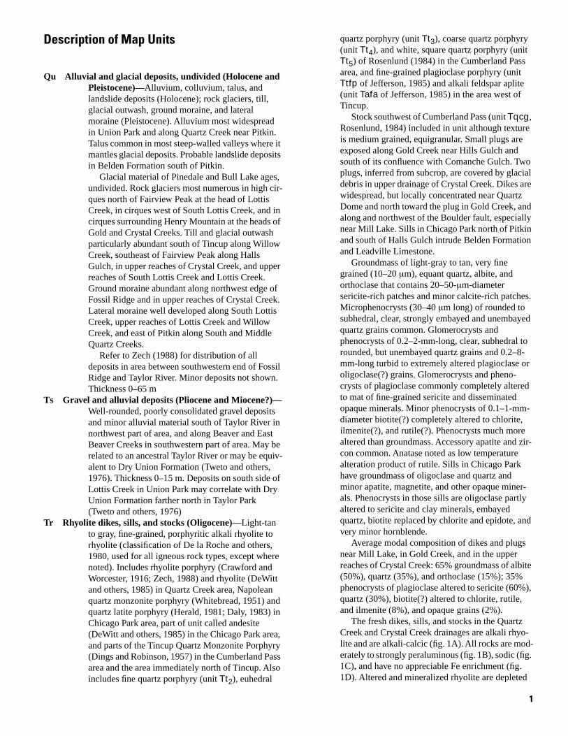
The fresh dikes, sills, and stocks in the Quartz Creek and Crystal Creek drainages are alkali rhyolite and are alkali-calcic (fig. 1A). All rocks are moderately to strongly peraluminous (fig. 1B), sodic (fig. 1C), and have no appreciable Fe enrichment (fig. 1D). Altered and mineralized rhyolite are depleted
1
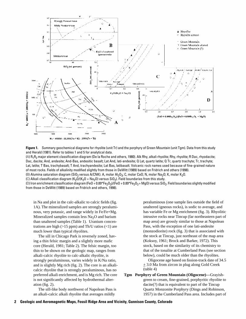
Figure 1. Summary geochemical diagrams for rhyolite (unit Tr) and the porphyry of Green Mountain (unit Tgm). Data from this study and Herald (1981). Refer to tables 1 and 5 for analytical data. (A) R1R2 major element classification diagram (De la Roche and others, 1980). Alk Rhy, alkali rhyolite; Rhy, rhyolite; R Dac, rhyodacite; Dac, dacite; And, andesite; And-Bas, andesitic basalt; Lat And, lati-andesite; Q Lat, quartz latite; Q Tr, quartz trachyte; Tr, trachyte; Lat, latite; T Bas, trachybasalt; T And, trachyandesite; Lat Bas, latibasalt. Volcanic rock names used because of fine-grained nature of most rocks. Fields of alkalinity modified slightly from those in DeWitt (1989) based on Fridrich and others (1998).(B) Alumina saturation diagram (SiO2 versus A/CNK). A, molar Al2O3; C, molar CaO; N, molar Na2O; K, molar K2O.(C) Alkali classification diagram (K2O/(K2O + Na2O) versus SiO2). Field boundaries from this study.(D) Iron enrichment classification diagram (FeO + 0.89*Fe2O3)/(FeO + 0.89*Fe2O3 + MgO) versus SiO2. Field boundaries slightly modified from those in DeWitt (1989) based on Fridrich and others, 1998).
in Na and plot in the calc-alkalic to calcic fields (fig. 1A). The mineralized samples are strongly peraluminous, very potassic, and range widely in Fe/Fe+Mg. Mineralized samples contain less Na2O and barium than unaltered samples (Table 1). Uranium concentrations are high (>15 ppm) and Th/U ratios (<1) are much lower than typical rhyolites.
The sill in Chicago Park is reversely zoned, having a thin felsic margin and a slightly more mafic core (Herald, 1981; Table 2). The felsic margin, too thin to be shown on the geologic map, ranges from alkali-calcic rhyolite to calc-alkalic rhyolite, is strongly peraluminous, varies widely in K/Na ratio, and is slightly Mg rich (fig. 2). The core is an alkalicalcic rhyolite that is strongly peraluminous, has no preferred alkali enrichment, and is Mg rich. The core is not significantly affected by hydrothermal alteration (fig. 2).
The sill-like body northwest of Napolean Pass is an alkali-calcic alkali rhyolite that averages mildly
peraluminous (one sample lies outside the field of unaltered igneous rocks), is sodic to average, and has variable Fe or Mg enrichment (fig. 3). Rhyolitic intrusive rocks near Tincup (far northeastern part of map area) are grossly similar to those at Napolean Pass, with the exception of one lati-andesite (monzodiorite) rock (fig. 3) that is associated with the stock at Tincup, just northeast of the map area (Koksoy, 1961; Brock and Barker, 1972). This stock, based on the similarity of its chemistry to that of the tonalite at Cumberland Pass (see section below), could be much older than the rhyolites.
Oligocene age based on fission-track date of 34.5 + 3.0 Ma from zircon in plug along Gold Creek (table 4)
Tgm Porphyry of Green Mountain (Oligocene)—Grayishgreen to cream, fine-grained, porphyritic rhyolite to dacite(?) that is equivalent to part of the Tincup Quartz Monzonite Porphyry (Dings and Robinson, 1957) in the Cumberland Pass area. Includes part of
2 Geologic and Aeromagnetic Maps, Fossil Ridge Area and Vicinity, Gunnison County, Colorado

-- -- -- -- -- -- -- --
-- --
-- -- -- -- -- -- -- --
-- -- -- -- -- -- --
-- -- -- -- -- -- --
-- -- -- -- -- -- --
-- -- -- -- -- -- -- --
-- -- -- -- -- -- -- --
-- -- -- -- -- -- -- --
-- -- -- -- -- -- -- -- --
-- -- -- -- -- -- ---- -- -- -- -- -- ---- -- -- -- -- -- ---- -- -- -- -- -- ---- -- -- -- -- -- ---- -- -- -- -- -- ---- -- -- -- -- -- ---- -- -- -- -- -- --
-- -- -- -- -- -- --
-- -- -- -- -- -- --
Table 1. Major- and minor-element chemistry of Oligocene rhyolite (unit Tr) from the Fossil Ridge and surrounding area, Gunnison County, Colorado.
[Major-element oxides (in weight percent) for samples collected in this study ( 8-, and 9- series) determined by X-ray fluorescence by A.J. Bartel, K.C. Stewart, and J.E. Taggart; H2O+ and H2O- determined by weight loss by H. Neiman and J. Ryder; CO2 determined by coulometric titration by H. Neiman and J. Ryder; FeO determined by potentiometric titration by H. Neiman and J. Ryder; Minor elements (in ppm) determined by energy-dispersive X-ray fluorescence by Ross Yeoman and Ed DeWitt; U and Th determined by delayed neutron activation by J. Storey, S. Danahey, R.B. Vaughn, and M. Coughlin; FetO3, total iron as Fe2O3; LOI, loss on ignition; --, not determined or calculated; R1, calculated values for R1R2 plot; R2, calculated values for R1R2; A/CNK, calculated values for SiO2 versus A/CNK plot; Fe No., calculated values for (FeO + 0.89Fe2O3)/(FeO + 0.89Fe2O3 + MgO) versus SiO2 plot; K No., calculated values for K2O/(K2O + Na2O) versus SiO2 plot; see Herald (1981) for analytical techniques for altered rhyolite samples beginning with HT-]
Condition fresh fresh altered altered altered altered altered altered altered altered Sample 8-11-82-1 8-5-82-1 HT-103 HT-122 HT-073 HT-072 9-6-83-1 HT-124 HT-080 HT-121 number
Major elements
SiO2
TiO2
Al2O3
Fe2O3
FetO3
FeO
MnO
MgO
CaO
Na2O
K2O
P2O5
H2O+
H2O-
CO2
LOI
TOTAL
Minor elements
Ba Rb Sr Y Zr Nb U Th Calculations
R1
R2
A/CNK Fe No. K No.
72.30 76.30 65.90 71.52 72.21 72.31 73.10 73.48 75.77 75.97
0.08 0.07 0.40 0.29 0.07 0.09 0.05 0.04 0.10 0.04
15.10 12.60 20.13 17.26 17.81 16.61 13.10 15.99 16.21 16.55
0.69 0.38
2.95 2.64 1.83 0.67 0.74 0.14 1.42 0.34
0.35 0.18
0.02 0.02 0.13
0.14 0.21 0.43 0.32 0.13 0.25 0.31 0.23 0.29 0.14
0.41 0.13 0.26 0.20 0.10 0.65 1.45 2.65 0.08 0.05
4.50 3.42 0.60
4.63 4.28 6.09 6.89 7.10 8.94 6.59 6.83 6.29 7.94
0.05 0.05 0.05
0.71 0.81
0.03 0.23
0.01 0.01
2.33
99.02 98.69 96.16 99.12 99.25 99.52 98.45 99.36 100.16 101.03
491 1144 86 131 221 326 275 48 40 13 6 17 78 64 74 66 32 39 3.3 17.0 21.1
< 2.6 24.0 < 7.3
2105 2849 2881 3079 3101 2707 3094 3292 3537 3193
347 272 444 376 367 408 428 609 341 337
1.15 1.20 1.22 0.87 0.71 0.86 0.88 0.93 0.71 0.68 0.35 0.82 0.69 0.51 0.56 0.92
unit called andesite by DeWitt and others (1985) in the Fossil Ridge area. Includes part of fine-grained quartz porphyry (unit Tt2) of Rosenlund (1984), southeast of Cumberland Pass. Andesine porphyry (unit Tt1) of Rosenlund (1984) on Napolean Pass, east of Cumberland Pass, is included in the unit because of its similar chemistry, but it may be a separate intrusive mass.
Groundmass of light-gray, very fine grained (10– 20 µm) mixture of quartz, oligoclase(?), and orthoclase containing <10-µm-diameter opaque grains and 30–45-µm-diameter clots of sericite and minor calcite. Microphenocrysts in groundmass are 40–50-µm-long clear apatite prisms and 40–50µm-diameter anhedral chlorite grains. Phenocrysts and glomerocrysts of 1–4-mm-long, euhedral
Description of Map Units 3

Table 2. Major- and minor-element chemistry of Oligocene porphyry near Chicago Park (unit Tr) from the Fossil Ridge and surrounding area, Gunnison County, Colorado.
[FetO3, total iron as Fe2O3; LOI, loss on ignition; --, not determined or calculated; R1, calculated values for R1R2 plot; R2, calculated values for R1R2; A/CNK, calculated values for SiO2 versus A/CNK plot; Fe No., calculated values for (FeO + 0.89Fe2O3)/(FeO + 0.89Fe2O3 + MgO) versus SiO2 plot; K No., calculated values for K2O/(K2O + Na2O) versus SiO2 plot; see Herald (1981) for analytical techniques for porphyry samples beginning with HT-; see Rosenlund (1984) for analytical techniques for porphyry samples beginning with TCFT-; see Daly (1983) for analytical techniques for all other porphyry samples]
Type Sill, border
Sill, border
Sill, border
Sill, border
Sill, border
Sill, border
Sill, border
Dike, border
Sill, border
Sill, border
Sample number HT-279 HT-189 HT-200B HT-310 HT-252 HT-335 HT-192 HT-262 HT-307 HT-290
Major elements
SiO2
TiO2
Al2O3
FetO3
MgO
CaO
Na2O
K2O
TOTAL
Calculations
R1
R2
A/CNK
Fe No.
K No.
71.52 72.01 72.55 72.70 72.79 73.28 73.58 73.82 74.02 74.95
0.05 0.05 0.05 0.06 0.05 0.05 0.05 0.05 0.05 0.05
16.91 15.98 16.22 16.09 16.02 16.47 16.45 15.79 16.75 16.69
0.36 0.24 0.65 0.28 0.62 0.57 0.55 0.63 0.25 0.55
0.36 0.20 0.14 0.08 0.32 0.09 0.14 0.16 0.22 0.09
2.60 2.24 0.15 0.93 1.29 0.16 0.14 0.19 0.14 0.10
1.86 2.69 3.17 3.70 2.77 3.54 3.10 3.20 1.87 3.44
4.52 3.88 4.78 4.01 4.26 3.93 4.62 4.48 4.71 2.83
98.18 97.29 97.71 97.85 98.12 98.09 98.63 98.32 98.01 98.70
3035 2925 2570 2581 2851 2688 2704 2715 3156 3092
628 563 341 419 468 345 345 338 355 343
1.34 1.26 1.52 1.33 1.39 1.59 1.59 1.51 1.99 1.88
0.47 0.52 0.81 0.76 0.64 0.85 0.78 0.78 0.51 0.85
0.71 0.59 0.60 0.52 0.61 0.53 0.60 0.58 0.72 0.45
Table 2. Major- and minor-element chemistry of Oligocene porphyry near Chicago Park—continued.
Type Sill, Sill, Sill, Sill, Sill, Sill, Sill, Sill, Sill, Sill, Sill, core core core core core core core core core core core
Sample number HT-184 HT-255 HT-294 HT-311 HT-129 HT-142 HT-152 HT-200A HT-258 HT-267 HT-157
Major elements
SiO2 68.69 68.93 69.23 69.37 69.62 69.86 69.86 70.06 70.11 71.18 71.33
TiO2 0.27 0.25 0.24 0.23 0.44 0.24 0.26 0.29 0.24 0.23 0.24
Al2O3 16.49 16.17 15.57 15.79 15.58 15.73 15.85 14.97 15.10 15.33 15.14
FetO3 2.08 2.09 2.06 1.98 1.98 1.99 2.14 2.44 2.04 1.85 2.00
MgO 0.72 0.76 0.75 0.78 0.76 0.80 0.78 0.76 0.62 0.66 0.72
CaO 0.49 1.54 1.31 1.53 2.61 0.93 0.68 0.58 1.07 0.77 1.13
Na2O 3.60 3.44 3.42 3.27 3.01 3.60 3.72 3.27 3.35 3.44 3.65
K2O 4.51 4.19 4.25 4.57 4.26 4.83 4.34 4.46 4.53 4.59 3.85
TOTAL 96.85 97.37 96.83 97.52 98.26 97.98 97.63 96.83 97.06 98.05 98.06
Calculations
R1 2183 2330 2344 2334 2511 2189 2256 2393 2363 2393 2497
R2 412 520 483 512 623 448 422 393 441 416 454
A/CNK 1.41 1.25 1.24 1.21 1.09 1.23 1.32 1.33 1.22 1.28 1.24
Fe No. 0.72 0.71 0.71 0.70 0.70 0.69 0.71 0.74 0.75 0.72 0.71
K No. 0.56 0.55 0.55 0.58 0.59 0.57 0.54 0.58 0.57 0.57 0.51
4 Geologic and Aeromagnetic Maps, Fossil Ridge Area and Vicinity, Gunnison County, Colorado
--
-- -- -- --
--
-- -- -- --
--
Table 2. Major- and minor-element chemistry of Oligocene porphyry near Chicago Park—continued.
Type Sill, border Dike Sill, core Sill, altered Dike, border altered
Sample number 49 26 33 TCFT9 7
Major elements
SiO2
TiO2
Al2O3
Fe2O3
FetO3
FeO
MnO
MgO
CaO
Na2O
K2O
P2O5
TOTAL
Calculations
R1
R2
A/CNK
Fe No.
K No.
73.90 74.70 75.50 67.10 70.50
0.50 0.06 0.50 0.37
12.10 14.60 11.30 14.20 15.70
1.10
2.90 0.60 3.10 3.50
0.54
0.05 0.08 0.06 0.06
1.00 0.15 1.20 0.63 0.48
0.95 0.12 0.92 1.50 0.24
2.00 3.94 2.30 4.00 0.47
4.50 4.75 4.60 4.50 6.31
0.18 0.05 0.19 0.02 0.19
98.08 99.05 99.67 93.59 97.82
3073 2448 3045 1953 2956
389 307 380 470 358
1.23 1.24 1.08 1.00 1.96
0.72 0.78 0.70 0.71 0.87
0.69 0.55 0.67 0.53 0.93
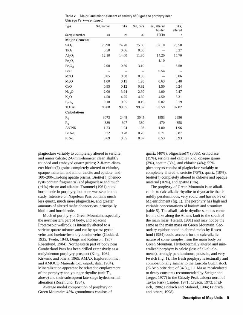
plagioclase variably to completely altered to sericite and minor calcite; 2-6-mm-diameter clear, slightly rounded and embayed quartz grains; 2–8-mm-diam-eter biotite(?) grains completely altered to chlorite, opaque material, and minor calcite and epidote; and 100–200-µm-long apatite prisms. Biotite(?) phenocrysts contain fragments(?) of plagioclase and much (~1%) zircon and allanite. Trammel (1961) noted hornblende in porphyry, but none was seen in this study. Intrusive on Napolean Pass contains much less quartz, much more plagioclase, and greater amounts of altered mafic phenocrysts, principally biotite and hornblende.
Much of porphyry of Green Mountain, especially the northeastern part of body, and adjacent Proterozoic wallrock, is intensely altered to a sericite-quartz mixture and cut by quartz-pyrite veins and huebnerite-molybdenite veins (Goddard, 1935; Tweto, 1943; Dings and Robinson, 1957; Rosenlund, 1984). Northeastern part of body near Cumberland Pass has been drilled extensively as a molybdenum porphyry prospect (King, 1964; Kirkemo and others, 1965; AMAX Exploration Inc., and AMOCO Minerals Co., unpub. data, 1984). Mineralization appears to be related to emplacement of the porphyry and younger rhyolite (unit Tr, above) and their subsequent late-stage hydrothermal alteration (Rosenlund, 1984).
Average modal composition of porphyry on Green Mountain: 45% groundmass consists of
quartz (40%), oligoclase(?) (30%), orthoclase (15%), sericite and calcite (5%), opaque grains (3%), apatite (3%), and chlorite (4%); 55% phenocrysts consist of plagioclase variably to completely altered to sericite (75%), quartz (10%), biotite(?) completely altered to chlorite and opaque material (10%), and apatite (5%).
The porphyry of Green Mountain is an alkalicalcic to calc-alkalic rhyolite to rhyodacite that is mildly peraluminous, very sodic, and has no Fe or Mg enrichment (fig. 1). The porphyry has high and variable concentrations of barium and strontium (table 5). The alkali-calcic rhyolite samples come from a dike along the Athens fault to the south of the main mass (Herald, 1981) and may not be the same as the main mass on Green Mountain. Secondary epidote noted in altered rocks by Rosenlund (1984) could account for the calc-alkalic nature of some samples from the main body on Green Mountain. Hydrothermally altered and mineralized porphyry is calcic (loss of alkali elements), strongly peraluminous, potassic, and very Fe rich (fig. 1). The fresh porphyry is texturally and compositionally similar to the Lincoln Gulch stock (K-Ar biotite date of 34.8 + 1.1 Ma as recalculated to decay constants recommended by Steiger and Jaeger, 1977) in the Grizzly Peak caldera north of Taylor Park (Candee, 1971; Cruson, 1973; Fridrich, 1986; Fridrich and Mahood, 1984; Fridrich and others, 1998).
Description of Map Units 5

Figure 2. Summary geochemical diagrams for rhyolite (unit Tr) from the Chicago Park area. Rock names listed in figure 1. Data from Herald (1981), Daly (1983), and Rosenlund (1984). Refer to table 2 for analytical data.(A) R1R2 major element classification diagram (De la Roche and others, 1980). Volcanic rock names used because of fine-grained nature of most rocks. See figure 4 for the equivalent plutonic rock names. Fields of alkalinity modified slightly from those in DeWitt (1989) based on Fridrich and others (1998).(B) Alumina saturation diagram (SiO2 versus A/CNK). A, molar Al2O3; C, molar CaO; N, molar Na2O; K, molar K2O. Samples outside the outlined box plot well above the field of unaltered rocks.(C) Alkali classification diagram (K2O/(K2O + Na2O) versus SiO2). Field boundaries from this study.(D) Iron enrichment classification diagram (FeO + 0.89*Fe2O3)/(FeO + 0.89*Fe2O3 + MgO) versus SiO2. Field boundaries slightly modified from those in DeWitt (1989) based on Fridrich and others, 1998).
Oligocene age assignment of the porphyry of Green Mountain based on fission-track date of 34.5 + 2.8 Ma from zircon collected 0.2 km west of summit of Green Mountain (Naeser and Cunningham, 1976; Cunningham and others, 1977). Porphyry intruded Fairview Peak Granodiorite (newly named) in the east as a west-trending dike, but to the west was emplaced as a sill cutting up into Sawatch Quartzite
TKt Tonalite stock and sill at Cumberland Pass (early Tertiary to Late Cretaceous?)—Dark-greenishgray, medium-grained, equigranular to porphyritic hornblende-biotite tonalite near Cumberland Pass that is equivalent to quartz diorite porphyry stock of Dings and Robinson (1957), tonalite porphyry stock of Trammel (1961), and granodiorite (unit Tgd) and diorite porphyry (unit Tdp) of Rosenlund (1984). Includes part of unit called andesite (DeWitt and others, 1985) in the Cumberland Pass area. Stock consists of two textural varieties, a diabasic core and an equigranular to porphyritic, variably flow-foliated margin. According to Trammel (1961), the diabasic core contains labradorite,
pyroxene mantled by hornblende, biotite, minor orthoclase, and very little quartz. Equigranular to porphyritic margin contains andesine, hornblende containing pyroxene cores, orthoclase, biotite, and quartz. Rosenlund (1984) did not note pyroxene in the stock or sill. Granite dikelets cut the stock and Paleozoic sedimentary rocks east of Cumberland Pass; dikelets may be late-stage intrusives related to the granodiorite (Trammel, 1961), but may also be related to granitic bodies in the Cumberland Pass area (Rosenlund, 1984) shown as unit Tr.
Average modal composition of stock, according to Trammel (1961) and Rosenlund (1984): andesine [An40 ] (40–45%), quartz (15–18%), hornblende (8–18%), orthoclase (16–26%), biotite (7–8%), pyroxene (trace-5%), magnetite (2-4%), and accessory sphene, apatite, and zircon (Trammel, 1961). Sill (Rosenlund, 1984) contains 60– 65% plagioclase, 3–5% quartz, 30% combined hornblende and biotite, 0.5% magnetite, 1.5% orthoclase, and trace amounts of sphene, apatite, and zircon.
6 Geologic and Aeromagnetic Maps, Fossil Ridge Area and Vicinity, Gunnison County, Colorado
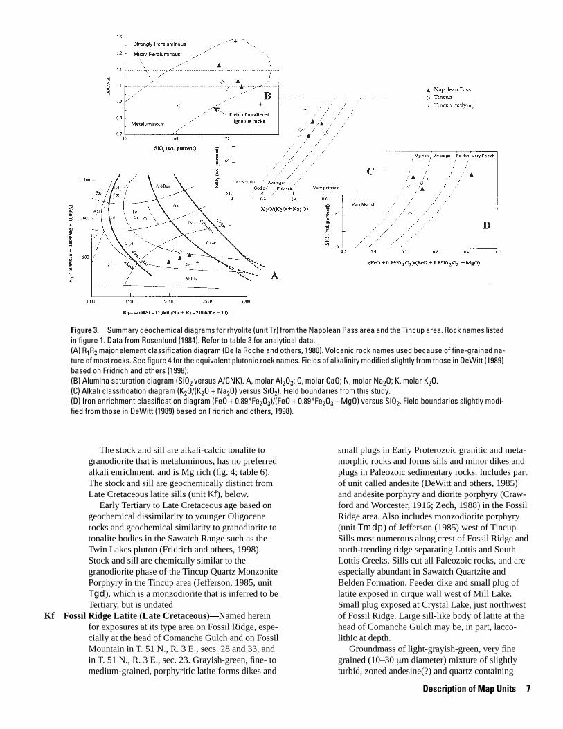
Figure 3. Summary geochemical diagrams for rhyolite (unit Tr) from the Napolean Pass area and the Tincup area. Rock names listed in figure 1. Data from Rosenlund (1984). Refer to table 3 for analytical data.(A) R1R2 major element classification diagram (De la Roche and others, 1980). Volcanic rock names used because of fine-grained nature of most rocks. See figure 4 for the equivalent plutonic rock names. Fields of alkalinity modified slightly from those in DeWitt (1989) based on Fridrich and others (1998).(B) Alumina saturation diagram (SiO2 versus A/CNK). A, molar Al2O3; C, molar CaO; N, molar Na2O; K, molar K2O.(C) Alkali classification diagram (K2O/(K2O + Na2O) versus SiO2). Field boundaries from this study.(D) Iron enrichment classification diagram (FeO + 0.89*Fe2O3)/(FeO + 0.89*Fe2O3 + MgO) versus SiO2. Field boundaries slightly modified from those in DeWitt (1989) based on Fridrich and others, 1998).
The stock and sill are alkali-calcic tonalite to granodiorite that is metaluminous, has no preferred alkali enrichment, and is Mg rich (fig. 4; table 6). The stock and sill are geochemically distinct from Late Cretaceous latite sills (unit Kf), below.
Early Tertiary to Late Cretaceous age based on geochemical dissimilarity to younger Oligocene rocks and geochemical similarity to granodiorite to tonalite bodies in the Sawatch Range such as the Twin Lakes pluton (Fridrich and others, 1998). Stock and sill are chemically similar to the granodiorite phase of the Tincup Quartz Monzonite Porphyry in the Tincup area (Jefferson, 1985, unit Tgd), which is a monzodiorite that is inferred to be Tertiary, but is undated
Kf Fossil Ridge Latite (Late Cretaceous)—Named herein for exposures at its type area on Fossil Ridge, especially at the head of Comanche Gulch and on Fossil Mountain in T. 51 N., R. 3 E., secs. 28 and 33, and in T. 51 N., R. 3 E., sec. 23. Grayish-green, fine- to medium-grained, porphyritic latite forms dikes and
small plugs in Early Proterozoic granitic and metamorphic rocks and forms sills and minor dikes and plugs in Paleozoic sedimentary rocks. Includes part of unit called andesite (DeWitt and others, 1985) and andesite porphyry and diorite porphyry (Craw-ford and Worcester, 1916; Zech, 1988) in the Fossil Ridge area. Also includes monzodiorite porphyry (unit Tmdp) of Jefferson (1985) west of Tincup. Sills most numerous along crest of Fossil Ridge and north-trending ridge separating Lottis and South Lottis Creeks. Sills cut all Paleozoic rocks, and are especially abundant in Sawatch Quartzite and Belden Formation. Feeder dike and small plug of latite exposed in cirque wall west of Mill Lake. Small plug exposed at Crystal Lake, just northwest of Fossil Ridge. Large sill-like body of latite at the head of Comanche Gulch may be, in part, laccolithic at depth.
Groundmass of light-grayish-green, very fine grained (10–30 µm diameter) mixture of slightly turbid, zoned andesine(?) and quartz containing
Description of Map Units 7

-- -- --
-- -- --
-- -- --
Table 3. Major- and minor-element chemistry of Oligocene quartz porphyry near Napolean Pass (unit Tr) and rocks in the Tincup area (units Tr and TKt?) from the Fossil Ridge and surrounding area, Gunnison County, Colorado.
[FetO3, total iron as Fe2O3; LOI, loss on ignition; --, not determined or calculated; R1, calculated values for R1R2 plot; R2, calculated values for R1R2; A/CNK, calculated values for SiO2 versus A/CNK plot; Fe No., calculated values for (FeO + 0.89Fe2O3)/(FeO + 0.89Fe2O3 + MgO) versus SiO2 plot; K No., calculated values for K2O/(K2O + Na2O) versus SiO2 plot; see Rosenlund (1984) for analytical techniques for porphyry samples beginning with TCFT; see Jefferson (1985) for analytical techniques for all other samples]
Unit Tr Tr Tr TKt Tr? Tr Tr Tr Sample number TCFT-6 TCFT-1 TCFT-5 Tgd Ttcp Ttep Ttfp Tafa
Major elements
SiO2
TiO2
Al2O3
FetO3
FeO
MnO
MgO
CaO
Na2O
K2O
P2O5
LOI
TOTAL
Calculations
R1
R2
A/CNK
Fe No.
K No.
68.20 71.9 72.60 60.50 68.90 70.00 71.40 76.30
0.83 0.38 0.37 0.23 0.06
15.30 15.10 15.30 16.80 14.80 15.60 15.50 12.70
0.43 1.30 0.30 3.40 1.60 1.60 1.70 0.27
1.70 1.20 0.62 3.10 1.60 1.30 1.20 0.46
0.08 0.03 0.02 0.02 0.01
0.66 0.88 0.08 2.40 1.20 0.88 0.79 0.12
1.50 1.80 1.30 5.10 2.00 2.30 0.80 1.70
4.00 3.60 4.60 4.30 3.30 4.70 3.90 4.30
4.00 5.10 5.10 2.70 5.10 3.80 4.00 3.90
0.07 0.06 0.02 0.26 0.16 0.15 0.12 0.02
0.60 0.90 0.70 1.40 1.00
95.86 100.94 99.92 100.07 99.97 101.42 101.06 100.84
2128 2251 1984 1678 2130 2018 2353 2621
493 532 443 994 564 596 429 437
1.12 1.03 0.99 0.87 1.02 0.98 1.27 0.88
0.76 0.73 0.92 0.72 0.72 0.76 0.78 0.85
0.50 0.59 0.53 0.39 0.61 0.45 0.51 0.48
Table 4. Fission-track data for Late Cretaceous and Oligocene igneous rocks, Fossil Ridge area, Gunnison County, Colorado
[Decay constant, 7.03 x 10⁻¹⁷/yr; (436), number of tracks counted; DF-4948, laboratory number; Analyses by C.W. Naeser, U.S. Geological Survey, Denver, CO]
Sample Mineral Fossil tracks Induced tracks Dose Date +/- 2 sigma No. of U (x 10-6 t/cm2) (x 10-6 t/cm2) (x 10-15) (Ma) (Ma) grains (ppm)
Fossil Ridge Latite
FR-UM-AND
zircon 5.26 4.19 0.756 56.6 6.85 6 180
(DF-4948) (1096) (436)
Rhyolite
9-6-83-4 zircon 7.86 10.28 0.756 34.5 3.0 6 430
(DF-4949) (1492) (976)
50–150-µm-diameter, irregularly shaped clots of slightly to highly pleochroic epidote or zoisite and minor chlorite. Microphenocrysts in groundmass are 30–60-µm-diameter apatite and sphene and minor hornblende. Phenocrysts are 0.5–6-mm-diameter euhedral, twinned, and oscillatorially zoned plagioclase, variably to completely altered to sericite and nonpleochroic zoisite(?); 0.2–3-mm-long dark green hornblende that is unaltered to variably replaced by calcite, epidote, and chlorite;
0.3–0.5-mm-diameter euhedral apatite; and 0.3–1-mm-long euhedral and variably needle-like sphene. Zircon common in groundmass. Red-brown, twinned, 0.1–0.2-mm-diameter allanite noted locally. Clots of epidote or zoisite in groundmass locally appear to fill vug-like cavities containing 0.2–0.5-mm-diameter quartz grains and 0.5–0.75 mm calcite grains.
Average modal composition of the latite: 50% groundmass consists of oligoclase and andesine(?)
8 Geologic and Aeromagnetic Maps, Fossil Ridge Area and Vicinity, Gunnison County, Colorado

-- --
-- -- -- -- -- --
-- -- -- --
-- -- -- -- -- --
-- -- -- -- -- -- -- --
--
-- -- -- -- -- --
-- -- -- -- -- -- -- -- --
-- -- -- -- -- -- -- -- --
-- -- -- -- -- -- -- -- --
-- -- -- -- -- -- -- -- --
-- -- -- -- -- -- -- --
-- -- -- -- -- -- -- --
-- -- -- -- -- -- -- --
-- -- -- -- -- -- -- --
-- -- -- -- -- -- -- --
-- -- -- -- -- -- -- --
-- -- -- -- -- -- -- -- --
-- -- -- -- -- -- -- -- --
--
--
Table 5. Major- and minor-element chemistry of Oligocene porphyry of Green Mountain (unit Tgm) from the Fossil Ridge and surrounding area, Gunnison County, Colorado.
[Major-element oxides (in weight percent) for samples collected in this study (7- series) determined by X-ray fluorescence by A.J. Bartel, K.C. Stewart, and J.E. Taggart; H2O+ and H2O- determined by weight loss by H. Neiman and J. Ryder; CO2 determined by coulometric titration by H. Neiman and J. Ryder; FeO determined by potentiometric titration by H. Neiman and J. Ryder; Minor elements (in ppm) determined by energy-dispersive X-ray fluorescence by Ross Yeoman and Ed DeWitt; U and Th determined by delayed neutron activation by J. Storey, S. Danahey, R.B. Vaughn, and M. Coughlin; major elements for sample 7-27-82-1 determined by X-ray fluorescence by Bondar-Clegg Laboratories, Vancouver, British Columbia, courtesy of Magmachem Exploration, Seattle, WA; FetO3, total iron as Fe2O3; LOI, loss on ignition; --, not determined or calculated; R1, calculated values for R1R2 plot; R2, calculated values for R1R2; A/CNK, calculated values for SiO2 versus A/CNK plot; Fe No., calculated values for (FeO + 0.89Fe2O3)/(FeO + 0.89Fe2O3 + MgO) versus SiO2 plot; K No., calculated values for K2O/ (K2O + Na2O) versus SiO2 plot; see Herald (1981) for analytical techniques for mineralized porphyry samples beginning with HT-; see Rosenlund (1984) for analytical techniques for mineralized porphyry samples beginning with TCFT-]
Sample number 7-12-82-1 7-27-82-1 TCFT-3 TCFT-4 HT-223 HT-217 HT-229 HT-239 HT-235 HT-216
Major elements
SiO2
TiO2
Al2O3
Fe2O3
FetO3
FeO
MnO
MgO
CaO
Na2O
K2O
P2O5
H2O+
H2O-
CO2
LOI
TOTAL
Minor elements
Ba
Rb
Sr
Y
Zr
Nb
U
Th
Calculations
R1
R2
A/CNK
Fe No.
K No.
67.20 68.28 69.10 69.50 67.71 70.20 60.72 63.12 63.17 63.56
0.25 0.25 0.33 0.33 0.38 0.39 0.48 0.28
16.10 16.28 16.10 15.70 19.73 19.03 17.42 16.90 17.09 17.74
1.15 1.80 1.70 2.70
5.87 5.22 4.56 4.70 5.25 2.94
1.25 0.50 1.00 1.40
0.05 0.03
0.58 0.64 0.78 0.96 0.86 0.53 0.97 0.06 0.05 0.48
1.78 2.17 3.60 4.30 0.25 0.21 2.29 0.70 0.67 4.94
4.97 5.65 3.80 4.30 0.13 4.87 4.75 3.87 3.05
3.50 2.55 3.10 3.00 3.31 3.37 2.63 3.03 3.60 2.79
0.12 0.24 0.02 0.05
1.10
0.02
0.77
1.50
98.84 99.89 99.20 101.91 98.19 98.89 93.84 93.65 94.18 95.78
1720 970
79 71
1054 440
13 < 5
179 160
22 29
2.4
7.8
1822 1879 2457 2293 3533 3747 1575 1681 1847 2416
535 583 740 816 457 422 635 409 409 900
1.06 1.02 1.00 0.87 4.65 1.16 1.37 1.49 1.04
0.80 0.77 0.76 0.80 0.86 0.90 0.81 0.99 0.99 0.85
0.41 0.31 0.45 0.41 0.96 0.35 0.39 0.48 0.48
(65%), quartz (25%), epidote and zoisite (5%), calcite (2%), and microphenocrysts of opaque material, apatite, and sphene (3%); 50% phenocrysts consist of plagioclase variably to completely altered to sericite and zoisite(?) (65%), hornblende variably altered to chlorite, epidote, and calcite (30%), sphene (3%), and apatite (2%).
The sills, dikes, and plugs are alkali-calcic to slightly alkalic latite (plutonic equivalent is
monzonite) that is metaluminous and that has no preferred alkali or Fe enrichment (fig. 4). Latite is characterized (table 6) by very high concentrations of strontium (>1,000 ppm) and high zirconium (>200 ppm).
Late Cretaceous age based on 40Ar/39Ar hornblende plateau date of 69.0 + 1.0 Ma from dike cutting basement rocks west of Fossil Ridge (table 7; fig. 5A). A sample from a sill in Sawatch Quartzite
Description of Map Units 9

Figure 4. Summary geochemical diagrams for Fossil Ridge Latite (unit Kf) and tonalite at Cumberland Pass (unit TKt). Gr, granite (equivalent to rhyolite); Gd, granodiorite (equivalent to rhyodacite); Ton, tonalite (equivalent to dacite); Mon, monzonite (equivalent to latite). Data from this study, Jefferson (1985), and Earley (1987). Refer to table 6 for analytical data.(A) R1R2 major element classification diagram (De la Roche and others, 1980. Fields of alkalinity modified slightly from those in DeWitt (1989) based on Fridrich and others (1998).(B) Alumina saturation diagram (SiO2 versus A/CNK). A, molar Al2O3; C, molar CaO; N, molar Na2O; K, molar K2O.(C) Alkali classification diagram (K2O/(K2O + Na2O) versus SiO2). Field boundaries from this study.(D) Iron enrichment classification diagram (FeO + 0.89*Fe2O3)/(FeO + 0.89*Fe2O3 + MgO) versus SiO2. Field boundaries slightly modified from those in DeWitt (1989) based on Fridrich and others (1998).
just north of the map area gave a slightly disturbed spectra, with most of the calculated dates in the range of 70–72 Ma (table 7; fig. 5B). The 40Ar/39Ar data indicate that the latite was emplaced near the end of the Late Cretaceous. A fission-track date of 56.6 + 6.8 Ma for zircon from latite (table 4) indicates regional uplift and cooling of surrounding rocks in early Eocene time, which is in agreement with uplift of the ancestral Sawatch Range at that time (Bryant and Naeser, 1980)
Ku Sedimentary rocks, undivided (Upper Cretaceous)— Includes shale and sandstone younger than the Dakota Sandstone, principally the Mancos Shale. Mapped only in the northeastern part of the Almont area. Thickness undetermined
Kd Dakota Sandstone (Upper Cretaceous)—White and tan to yellowish, medium- to coarse-grained, cliff-forming sandstone. Upper part friable, thin-bedded sand-stone and minor siltstone and shale. Locally contains plant remains. Lower part cross-bedded, locally quartzitic sandstone containing basal, coarse-grained quartz or chert pebble conglomerate.
Locally contains petrified wood. Thickness 50–60 m. Exposed in southwestern part of area, southwest of Beaver Creek, and in Almont area
Jm Morrison Formation (Upper Jurassic)—Variegated green to red-brown calcareous siltstone, shale, and mudstone containing local lenses and channel fillings of fine-grained calcareous sandstone. Thickness 40 m. Exposed in southwestern part of area, southwest of Beaver Creek, and in Almont area
Jj Junction Creek Sandstone (Upper Jurassic)—White to yellowish, medium- to fine-grained aeolian quartz sandstone containing local large-scale cross-beds. Local quartz pebble conglomerate at base. Thickness 10–20 m. Exposed in southwestern part of area, southwest of Beaver Creek, and in Almont area
Jmj Morrison Formation and Junction Creek Sandstone (Upper Jurassic)— Combined unit shown in Almont area
�g Gothic Formation (Middle Pennsylvanian)—Light- to dark-gray, pale-green, and brown interbedded
10 Geologic and Aeromagnetic Maps, Fossil Ridge Area and Vicinity, Gunnison County, Colorado

-- -- --
--
-- -- -- -- -- -- --
--
-- -- --
-- -- -- -- --
-- -- -- -- -- --
-- -- -- -- --
-- -- -- -- -- --
-- -- -- --
-- -- --
-- -- -- --
-- -- -- --
-- -- -- --
-- -- -- -- --
-- -- -- -- --
-- -- -- -- --
Table 6. Major- and minor-element chemistry of Tertiary-Cretaceous tonalite at Cumberland Pass (unit TKt) and Fossil Ridge Latite (unit Kf) from the Fossil Ridge and surrounding area, Gunnison County, Colorado.
[Major-element oxides (in weight percent) for samples collected in this study (7- and 8- series) determined by X-ray fluorescence by A.J. Bartel, K.C. Stewart, and J.E. Taggart; H2O+ and H2O- determined by weight loss by H. Neiman and J. Ryder; CO2 determined by coulometric titration by H. Neiman and J. Ryder; FeO determined by potentiometric titration by H. Neiman and J. Ryder; Minor elements (in ppm) determined by energy-dispersive X-ray fluorescence by Ross Yeoman and Ed DeWitt; U and Th determined by delayed neutron activation by J. Storey, S. Danahey, R.B. Vaughn, and M. Coughlin; FetO3, total iron as Fe2O3; LOI, loss on ignition; --, not determined or calculated; R1, calculated values for R1R2 plot; R2, calculated values for R1R2; A/CNK, calculated values for SiO2 versus A/CNK plot; Fe No., calculated values for (FeO + 0.89Fe2O3)/ (FeO + 0.89Fe2O3 + MgO) versus SiO2 plot; K No., calculated values for K2O/(K2O + Na2O) versus SiO2 plot; see Jefferson (1985) for analytical techniques for latite sample beginning with TMdp; see Earley (1987) for analytical techniques for latite sample beginning with 38]
Map unit TKt TKt TKt Kf Kf Kf Kf Kf Sample number TCFT-8 TCFT-2B TCFT-7 8-4-82-4 8-4-82-2 7-14-82-3 38 Tmdp
Major elements
SiO2
TiO2
Al2O3
Fe2O3
FetO3
FeO
MnO
MgO
CaO
Na2O
K2O
P2O5
H2O+
H2O-
CO2
LOI
TOTAL
Minor elements
Ba
Rb
Sr
Y
Zr
Nb
U
Th
Calculations
R1
R2
A/CNK
Fe No.
K No.
63.90 64.20 59.80 58.50 58.70 59.10 59.10 63.30
0.67 0.71 0.72 0.70 0.55
15.10 15.90 16.10 16.90 16.90 17.20 16.60 16.70
0.73 3.00 1.70 2.37 2.73 2.64 2.90
5.98
2.30 2.60 2.60 3.39 2.87 2.94 2.10
0.17 0.19 0.15 0.18 0.13
1.20 2.20 2.00 1.89 1.84 1.66 2.02 1.60
2.60 4.50 4.30 4.61 4.49 4.78 3.32 2.90
3.50 3.80 4.90 5.19 4.80 4.64 5.08 4.70
3.60 3.50 1.70 2.69 3.41 3.17 3.56 3.40
0.11 0.10 0.22 0.38 0.36 0.33 0.32 0.20
1.54 1.25 1.49
0.06 0.09
0.36 0.01 0.59
1.91 1.60
93.04 99.80 93.32 98.89 99.12 98.70 98.54 100.08
850 924 1090 1290
74 80 101 78 100
844 1213 1358 1016
21 28 29 28
217 216 214 226
30 28 29
3.6 4 4.5
12.8 12.5 14
2088 1960 1729 1257 1236 1381 1134 1607
634 902 875 918 903 931 781 717
1.05 0.87 0.91 0.85 0.86 0.87 0.91 1.00
0.71 0.71 0.67 0.74 0.75 0.76 0.72 0.75
0.51 0.48 0.26 0.34 0.42 0.41 0.41 0.42
shale, sandstone, and pebble conglomerate that northwestern part of area, on ridge tops north of form tree-covered slopes. Upper 15 m is sandstone Doctor Parkand interbedded shale. Basal 100 m is covered by �b Belden Formation (Middle Pennsylvanian)—Dark-gray dense stands of aspen, but appears to be shale con- to brownish-black, locally carbonaceous shale; taining interbedded sandstone. Thickness about 130 dark-gray to black, dense limestone; and light-gray m; upper part removed by erosion. Exposed only in to grayish-green and yellowish-gray, fine-grained,
Description of Map Units 11

Table 7. 40Ar/39Ar analytical data for hornblende from sill and dike of Fossil Ridge Latite (unit Kf), Fossil Ridge area.
[40ArR, radiogenic 40Ar; 39ArK, 39Ar produced from 39K by neutron interaction; 36ArCa, 36Ar produced from calcium by neutron interaction;
uncertainty in date (+2 sigma) is an estimated analytical uncertainty calculated in the manner suggested by Dalrymple and Lanphere (1974); Analyses by E. DeWitt and M. Kunk, U.S. Geological Survey]
Temp, 40Ar/39Ar 37Ar/39Ar 36Ar/39Ar 40ArR/39ArK 39ArK % of Apparent 40ArR (100)/ Date (Ma) +/-
˚ C measured measured measured total K/Ca 40Ar measured
Sample 7-14-82-3 J=0.007375 wt. = 0.3482 g Dike in Henry Mountain Granite
850 35.568 1.730 0.0960 7.335 0.8 0.03 20.6 5.05 + 0.98
1000 39.493 5.567 0.1102 7.366 1.3 0.009 18.7 95.44 + 0.86
1050 29.215 10.59 0.0692 9.579 0.6 0.005 32.8 123.15 + 0.91
1100 9.796 3.631 0.0151 5.604 4.6 0.14 57.2 73.06 + 0.38
1150 6.287 3.045 0.0044 5.329 16.4 0.17 84.8 69.54 + 0.46
1200 5.821 3.063 0.0027 5.256 19.2 0.17 90.3 68.60 + 0.41
1225 5.920 3.115 0.0029 5.278 10.7 0.17 89.2 68.89 + 0.34
1250 5.848 3.224 0.0027 5.287 12.2 0.16 90.5 69.01 + 0.35
1275 6.197 3.276 0.0037 5.334 5.0 0.16 86.1 69.60 + 0.35
1300 6.379 3.327 0.0043 5.347 4.8 0.16 83.9 69.78 + 0.40
FUSE 6.456 3.549 0.0044 5.423 24.4 0.15 84.0 70.75 + 0.45
Total Gas 70.56 Weight average plateau age (1150oC–1300oC) 68.96 + 0.49
Sample FR-UM-AND J=0.007367 wt.=0.4948g Sill in Sawatch Quartzite
700 49.250 2.590 0.0746 27.393 0.8 0.20 55.6 331.62 + 4.54
850 25.276 2.272 0.0511 10.341 0.5 0.23 40.9 132.48 + 1.37
1000 10.948 4.075 0.0172 6.167 2.6 0.13 56.4 80.16 + 0.86
1100 5.798 3.137 0.0025 5.370 34.6 0.16 92.7 70.00 + 0.35
1200 5.701 3.234 0.0017 5.424 35.0 0.16 95.2 70.68 + 0.36
1250 5.903 3.381 0.0020 5.572 17.8 0.15 94.2 72.57 + 0.38
FUSE 6.966 3.470 0.0056 5.583 8.7 0.15 80.2 72.71 + 0.37
Total Gas 73.89
NO PLATEAU
thin- to medium-bedded sandstone. Upper and middle parts of limestone, shaley limestone, and lime-stone breccia. Basal part consists of sandstone and interbedded shale.
Thicknesses, in a northwest to southeast section across the map, from Manganese Peak and Doctor Park (O'Connor, 1961); Fossil Ridge (Crawford and Worcester, 1916; Johnson, 1944; this study); Cross Mountain (Johnson, 1944; this study); Pitkin area (Whitebread, 1951; Daly, 1983); to Cumberland Pass and Tincup (Goddard, 1935; Koksoy, 1961; Jefferson, 1985; Rosenlund, 1984) are as follows: Doctor Park, as much as 200 m, but upper 15 m removed by erosion; on Fossil Ridge, 90 m, but upper part removed by erosion; north of Pitkin, at least 50 m; south of Pitkin and north of the Powder-house fault, as great as 280 m or more, but exact figure unknown; Cumberland Pass and Tincup, as great as 420 m, but exact figure unknown. Boulder
fault has decollement surface in part of Belden Formation
Ml Leadville Limestone (Lower Mississippian)—Dark-gray to dark-bluish-gray, cliff-forming, fossiliferous dolomite and limestone. Massive in upper part, medium to thick bedded and cherty in lower part.
Thickness not determined on Manganese Peak nor near Doctor Park, but about 91 m on Cement Creek, farther north; on Fossil Ridge at the head of Comanche Gulch, Leadville composed of high-calcium limestone (DeWitt and others, 1985) and is 99 m thick; north of Pitkin, 114–129 m; south of Tin-cup near Cumberland Pass, 80–90 m
MDc Chaffee Group (Lower Mississippian? and Upper Devonian)—Consists, from top to bottom, of dark-gray dolomitic breccia, thinly laminated dolomite, and thin-bedded, medium- to fine-grained sand-stone of the Gilman Sandstone (previously included by some workers as a basal sandstone in
12 Geologic and Aeromagnetic Maps, Fossil Ridge Area and Vicinity, Gunnison County, Colorado

1.0 1.0
K/C
a
K/C
a 0.1
7-14-82-3
Hornblende
Fossil Ridge Latite
Tp = 69.0 +/- 1.0 Ma
0.1
FR-UM-AND
Hornblende
Fossil Ridge Latite
T 1100-1200 = 70.3 +/- 0.7 Ma
0.01 0.01
125 125
100 100
75 75
50 50
25 0 100 25
0 PERCENT 39ArK RELEASED PERCENT 39ArK RELEASED
A B
Figure 5. 40Ar/39Ar release spectra for hornblende from Fossil Ridge Latite (unit Kf), Fossil Ridge area, Gunnison County, Colorado. (A), Hornblende from dike in Early Proterozoic basement; (B), Hornblende from sill in Paleozoic rocks.
AP
PAR
EN
T A
GE
(M
a)
AP
PAR
EN
T A
GE
(M
a)
the Leadville). Reddish-gray to grayish-pink and dark-gray, thin- to medium-bedded dolomite of the Dyer Dolomite underlies the Gilman. Grayish-orange, very thin- to thin-bedded sandy dolomite to dolomite and minor cross-bedded sandstone and shale of the Parting Formation underlies the Dyer. Individual formations of the Chaffee recognized in the Fossil Ridge and surrounding area, but group mapped as a whole.
Thickness north of Manganese Peak, 76 m, where Parting is 26 m and Dyer is 47 m; on Fossil Ridge, 97 m; on Cross Mountain, minimum of 64 m, where Parting is 30 m; in Pitkin area, thickness 49– 89 m, where Parting is 13–24 m and Dyer is 30 m; west of Tincup, 125 m, where Parting is 70 m and Dyer is 55 m; near Cumberland Pass, 56 m, where Parting is 21 m and Dyer is 35 m. Most thickness measurements did not consider Gilman Sandstone part of the Chaffee Group
Ofh Fremont Limestone (Upper Ordovician) and Harding Sandstone (Middle Ordovician)— Consists, from top to bottom, of brownish-gray to medium-gray massive dolomite of the Fremont. Dark-gray, jagged weathering surfaces of Fremont contain fragments of horn corals, chain corals, and crinoid stems. Yellowish-gray and light greenish-gray, fine- and
coarse-grained, massive to bioturbated, dolomitic sandstone of the Harding Sandstone underlies the Fremont and contains fragments of fossil fish plates. Weathers to a mottled light gray or white.
Thickness of Harding relatively constant from northwest to southeast, 1–3 m. Thickness of Fremont near Doctor Park, 19 m; on Fossil Ridge, 11– 15 m; on Cross Mountain, 10 m; in Pitkin area, 12– 33 m, west of Tincup, 15–30 m; near Cumberland Pass, 30 m
Om Manitou Dolomite (Lower Ordovician)—Mediumbluish-gray to light-brownish-gray, thin- to medium-bedded dolomite. Locally contains zones of thin-bedded, gray to black chert in upper and middle parts of unit.
Thickness near Manganese Peak, 66 m; on Fossil Ridge 47–64 m; near Taylor Park Dam, 63 m; on Cross Mountain, 61 m; near Pitkin, 76–80 m; west of Tincup and at Cumberland Pass, 75–85 m
Ou Fremont Limestone, Harding Sandstone, and Manitou Dolomite, undivided (Upper Ordovician to Lower Ordovician)
�s Sawatch Quartzite (Upper Cambrian)—White to grayish-pink and reddish-brown, fine- to coarse-grained, medium- to very thick bedded, silica cemented sandstone. Light-tan to buff, shaley limestone and
Description of Map Units 13
100

sandy shale of Peerless Formation, recognized by Johnson (1944) on Cross Mountain and by O'Connor (1961) near Manganese Peak, is included in Sawatch map unit.
Thickness near Manganese Peak, 78 m; on Fossil Ridge, 9–58 m, but averaging 36 m; on Cross Mountain, possibly as thick as 106 m, but structurally complicated by thrust faults; in Pitkin area, 7–40 m; west of Tincup, 35–45 m; at Cumberland Pass, 32 m
Yg Granite (Middle(?) Proterozoic)—Mass of fine-grained, equigranular, muscovite-biotite granite in far south-eastern corner of map that is northwesternmost exposure of large mass of granite on Monarch Pass and area to the north (Tweto and others, 1976). Middle(?) Proterozoic age assignment based on textural, mineralogical, and chemical (Ed DeWitt, unpub. data, 1990) similarity of granite to granitic bodies such as the St. Kevin Granite in the Sawatch Range
Yt Granite of Taylor River (Middle (?) Proterozoic)— Exposed along the Taylor River, especially in the steep canyon walls between Crystal Creek and South Lottis Creek in T. 15 S., R. 83 W., secs., 9 and 10. Body extends past map area to north and west and is exposed in the steep canyon walls of Spring Creek, northeast of Almont. Granite extends north of the map area and crops out in the southwest and western parts of Taylor Park, north of Fossil Ridge (Fridrich and others, 1998). Granite not exposed east of Gold Creek, the Cameron Creek fault, or Cross Mountain. Known southernmost part is body south of Comanche Creek on the north side of the Willow Monzonite (newly named). Pluton is a minimum of 12 mi by 12 mi in extent and was included in parts of Yg and YXg by Tweto (1979).
Granite is light tan to light gray, medium grained, equigranular to slightly porphyritic, homogeneous and undeformed except in shear zones and faults of Phanerozoic age, leucocratic, and is characterized by phenocrysts of both muscovite and biotite. Characteristic turbid plagioclase (0.5–2.5-mm diameter) that is altered to sericite was originally oligoclase. Clear, unaltered intermediate microcline and perthite (1–10 mm diameter) form phenocrysts and overgrow plagioclase. Anhedral to amoeboid quartz is interstitial to feldspar. Minor myrmekite is noted along phenocryst margins. Muscovite (0.4–2.5 mm diameter) forms both original phenocrysts and minor alteration products along cleavage traces of plagioclase. Green to brown, ragged, ilmenite(?)-rich biotite (0.2–1.0 mm diameter) is less abundant than muscovite. Pink garnet (0.1–0.2 mm diamteer) that ranges from fresh to variably resorbed and cracked is characteristic of the most leucocratic varieties of granite.
Average modal composition of the most mafic phase (#6-30-82-6) is oligoclase (37%), microcline and perthite (22%), quartz (32%), biotite (5%), muscovite (3.5%), ilmenite (0.2%), and epidote (0.1%),
and traces of apatite and zircon. Average modal composition of the least leucocratic phase (#7-13-82-6) is oligoclase (21%), microcline and perthite (23%), quartz (44%), muscovite (11%), garnet (0.8%), ilmenite (0.2%), and traces of apatite and zircon.
The granite is alkali-calcic, strongly peraluminous, and has little alkali or Fe enrichment (fig. 6). The granite is characterized by Sr and Zr concentrations averaging less than 100 ppm and U concentrations of 3–14 ppm (table 8). Granite of similar textural, mineralogic, and chemical composition is exposed along Spring Creek, to the north of the map area, and appears to be the granite of Taylor River. Both are similar in composition to the St. Kevin Granite in the Sawatch Range (fig. 6), but characterized by lower concentrations of Th (Fridrich and others, 1998).
Middle Proterozoic age is based on Rb-Sr geochronology of Wetherill and Bickford (1965) and U-Th-Pb geochronology of this study. Sample #CO-64 of Wetherill and Bickford (1965), from the granite of Taylor River, has a whole-rock potassium feldspar-plagioclase-muscovite isochron of 1380 + 19 Ma (mean squares of the weighted deviates (MSWD) of 0.03 recalculated by Ed DeWitt using program of Ludwig, 1990) and an initial 87Sr/86Sr ratio (Sri) of 0.715. The granite must have been formed from partial melting of Early Proterozoic crustal materials or must have been extensively contaminated with rubidium-rich crust to have a Sri ratio this high. Muscovite containing traces of quartz and feldspar from the granite of Taylor River near Lamphier Lake has a conventional K-Ar date of 1326 + 44 Ma (table 9). One zircon fraction from sample #6-30-82-6 along the Taylor River in T. 15 S., R. 83 W., sec. 9 has a 207Pb/206Pb date of 1406 Ma (Ed DeWitt and R.E. Zartman, unpub. data, 1990)
YXgb Gabbro dikes (Middle to Early Proterozoic)— Dark-greenish-black, fine-grained, equigranular to slightly porphyritic dikes of olivine gabbro composition. Most dikes 1–3 m wide and variably to highly foliated along their margins to mixture of biotite, dark-green chlorite, plagioclase, and minor black tourmaline. West- to northwest-striking dikes cut Henry Mountain Granite (newly named) in cirque wall south of Henry Mountain (T. 51 N., R. 3 E., sec. 15, northeast part) and cut Fairview Peak Granodiorite (newly named) along ridge north of Fairview Peak (T. 51 N., R. 4 E., sec. 9, central part). Includes some parts of quartz diorite of Zech (1988).
Subequal amounts of fine-grained, euhedral hornblende and biotite (maximum grain size of 0.2 x 0.3 mm) and interstitial plagioclase and minor quartz include and overgrow early allanite rimmed by epidote, sphene, and magnetite and apatite. Estimated
14 Geologic and Aeromagnetic Maps, Fossil Ridge Area and Vicinity, Gunnison County, Colorado

Figure 6. Summary geochemical diagrams for granite of Taylor River (unit Yt). Rock names listed in figure 4. Data from this study, Urbaniand Blackburn (1974), and Earley (1987). Refer to table 8 for analytical data.(A) R1R2 major element classification diagram (De la Roche and others, 1980). Fields of alkalinity modified slightly from those in DeWitt (1989) based on Fridrich and others (1998).(B) Alumina saturation diagram (SiO2 versus A/CNK). A, molar Al2O3; C, molar CaO; N, molar Na2O; K, molar K2O.(C) Alkali classification diagram (K2O/(K2O + Na2O) versus SiO2). Field boundaries from this study.(D) Iron enrichment classification diagram (FeO + 0.89*Fe2O3)/(FeO + 0.89*Fe2O3 + MgO) versus SiO2. Field boundaries slightly modified from those in DeWitt (1989) based on Fridrich and others (1998).
average mode is hornblende (35–40%), biotite (35– 40%), plagioclase (7–10%), quartz (2–5%), sphene (1–2.5%), magnetite plus ilmenite (0.2–0.7%), allanite and epidote (1–3%), and trace apatite.
One sample of the gabbro is alkali-calcic, metaluminous, very potassic, very Mg rich (fig. 7), and characterized by very high Rb (>3,500 ppm) and Sr (>1,300 ppm; table 10). Quartz-bearing gabbro plug in the Almont area (fig. 7) is potassic and very Mg rich, but is calcic and may result from pyroxene accumulation (plots outside the field of unaltered igneous rocks on fig. 7B). The elevated Rb, Sr, and K2O suggest that this gabbro may be unrelated to other, more numerous gabbro and metagabbro bodies discussed below.
Middle to Early Proterozoic age based on observation that dikes cut Henry Mountain Granite but have not been found cutting the granite of Taylor River. Dikes are similar in major-element composition to older metagabbro dikes(?) in the Almont area (Urbani and Blackburn, 1974), but their alkali-rich nature is distinctly different (fig. 7; table 10). Also, metagabbro dikes (?) in the
Almont area apparently are older than the granodiorite at Almont (biotite tonalite of Urbani and Blackburn, 1974), which we equate with the Fairview Peak Granodiorite. Dikes may be younger than the granite of Taylor River, but have a restricted areal extent. If so, the dikes may be about 1150 Ma and related to diabase dike and sill swarms that are common in Arizona and California (Granger and Raup, 1959; Shride, 1967; Wrucke, 1989). Dikes could also be Early Cambrian or Late Proterozoic and be related to mafic plutons and carbonatite complexes such as those in south-central Colorado (Olson and others, 1977; Armbrustmacher and Hedge, 1982; Bickford and others, 1989a)
Xa Granodiorite at Almont (Early Proterozoic)—Compositionally layered to massive biotite granodiorite that crops out in the Taylor River canyon at and downstream from Almont. Originally referred to as biotite tonalite (Urbani and Blackburn, 1974). Intrudes Early Proterozoic metasedimentary units, including metamorphosed sandstone, graywacke, and shale. Cut by quartz-bearing gabbro.
Description of Map Units 15

--
-- -- -- -- --
--
--
-- --
--
-- -- -- -- --
--
--
--
Table 8. Major- and minor-element chemistry of the Middle Proterozoic granite of Taylor River (unit Ye) from the Fossil Ridge and surrounding area, Gunnison County, Colorado.
[Major-element oxides (in weight percent) for samples collected in this study (7- and 8- series) determined by X-ray fluorescence by A.J. Bartel, K.C. Stewart, and J.E. Taggart; H2O+ and H2O- determined by weight loss by H. Neiman and J. Ryder; CO2 determined by coulometric titration by H. Neiman and J. Ryder; FeO determined by potentiometric titration by H. Neiman and J. Ryder; Minor elements (in ppm) determined by energy-dispersive X-ray fluorescence by Ross Yeoman and Ed DeWitt; U and Th determined by delayed neutron activation by J. Storey, S. Danahey, R.B. Vaughn, and M. Coughlin; major elements for sample 6-30-82-6 and 7-10-82-1 determined by X-ray fluorescence by Bondar-Clegg Laboratories, Vancouver, British Columbia, courtesy of Magmachem Exploration, Seattle, WA; FetO3, total iron as Fe2O3; LOI, loss on ignition; --, not determined or calculated; R1, calculated values for R1R2 plot; R2, calculated values for R1R2; A/CNK, calculated values for SiO2 versus A/CNK plot; Fe No., calculated values for (FeO + 0.89Fe2O3)/(FeO + 0.89Fe2O3 + MgO) versus SiO2 plot; K No., calculated values for K2O/(K2O + Na2O) versus SiO2 plot; see Earley (1987) for analytical techniques for granite samples beginning with 65; see Urbani (1975) for analytical techniques for granite samples beginning with CC]
Sample number 65G 6-30-82-6 7-10-82-4 7-10-82-1 7-13-82-6 8-5-82-2
Major elements
SiO2
TiO2
Al2O3
Fe2O3
FetO3
FeO
MnO
MgO
CaO
Na2O
K2O
P2O5
H2O+
H2O-
CO2
LOI
TOTAL
Minor elements
Ba
Rb
Sr
Y
Zr
Nb
U
Th
Calculations
R1
R2
A/CNK
Fe No.
K No.
72.10 72.60 72.80 73.10 74.20 74.30
0.13 0.16 0.10 0.11 0.04 0.05
14.22 14.20 14.50 14.20 14.20 14.40
0.78 0.36 0.33 0.28 0.24
1.21
0.49 1.22 0.79 0.21 0.17
0.02 0.02 0.04 0.03 0.15 0.08
0.23 0.36 0.32 0.31 0.05 0.05
0.73 1.17 0.84 0.62 0.74 0.58
2.95 3.03 3.32 3.08 4.00 3.90
5.97 5.03 5.41 5.45 4.12 4.52
0.09 0.09 0.14 0.14 0.05 0.05
0.49 0.53 0.65 0.38 0.42
0.01 0.01 0.01 0.01
0.01 0.06 0.02 0.01 0.01
0.56
98.21 98.83 99.24 98.84 98.43 98.77
501 508 310 308 49 58
296 213 305 283 421 433
87 95 67 73 22 21
44 25 33 32 34 38
114 135 100 80 35 29
20 30 23 42 48
4.89 3.98 4.76 12.00 13.90
27.30 14.00 18.00 16.10 < 5.2
2322 2536 2371 2467 2543 2494
368 422 390 360 360 347
1.13 1.13 1.13 1.18 1.15 1.17
0.84 0.81 0.77 0.78 0.90 0.89
0.67 0.62 0.62 0.64 0.51 0.54
Composition and texture similar to Fariview Peak sodic nature, high Sr concentration, and low Rb Granodiorite. (table 11) are distinguishing characteristics shared
The granodiorite is alkali-calcic to calc-alka- by the Kroenke Granodiorite (fig. 8) in the lic, metaluminous to strongly peraluminous, and Sawatch Range (Fridrich and others, 1998). The averages Mg rich (fig. 8). Similar in composi- granodiorite at Almont (fig. 8) shows greater tion to the Fairview Granodiorite. The unusual scatter on most diagrams, but has the same
16 Geologic and Aeromagnetic Maps, Fossil Ridge Area and Vicinity, Gunnison County, Colorado

-- -- --
-- -- -- --
-- -- --
-- -- --
-- -- -- -- -- --
-- -- -- -- -- --
-- -- -- -- -- --
-- -- -- --
-- -- --
-- -- --
-- -- --
-- -- --
Table 8. Major- and minor-element chemistry of the Middle Proterozoic granite of Taylor River—continued.
Sample number 7-7-82-2 8-8-82-4 7-26-82-3 7-2-82-4 CC299 CC297 CC298
Major elements
SiO2
TiO2
Al2O3
Fe2O3
FetO3
FeO
MnO
MgO
CaO
Na2O
K2O
P2O5
H2O+
H2O-
CO2
LOI
TOTAL
Minor elements
Ba
Rb
Sr
Y
Zr
Nb
U
Th
Calculations
R1
R2
A/CNK
Fe No.
K No.
74.70 74.70 74.80 76.60 72.95 73.82 74.29
0.07 0.11 0.09 0.02 0.28 0.05 0.22
14.10 13.10 13.30 12.60 13.22 13.04 12.68
0.23 1.11 0.08 0.30
1.17 1.18 0.21
0.24 1.73 1.20 1.57
0.10 0.03 0.05 0.03 0.04 0.03 0.03
0.14 0.30 0.30 0.01 0.51 0.05 0.48
0.56 0.54 0.54 0.10 1.04 0.42 0.66
3.64 3.36 3.35 1.37 3.17 4.40 3.36
4.37 4.60 4.44 7.33 5.09 4.73 5.43
0.13 0.09 0.10 0.12
0.51
0.01
0.04
0.69 0.70 0.53
98.84 98.69 98.85 98.91 99.14 97.82 99.02
125 220 150 75 791 184 449
274 296 334 504 254 332 257
33 43 31 27 127 77 141
13 42 38 1
37 104 92 22 185 50 150
20 35 43 58
2.74 13.60 7.28 2.46
5.20 20.60 19.50 < 2
2646 2674 2721 2895 2459 2211 2428
343 330 334 258 396 303 343
1.20 1.14 1.18 1.22 1.05 1.00 1.01
0.76 0.78 0.78 0.97 0.84 0.96 0.79
0.55 0.58 0.57 0.84 0.62 0.52 0.62
overall chemical attributes as the Fairview Granodiorite (table 11)
Xf Fairview Peak Granodiorite (Early Proterozoic)—Named herein for exposures at its type area on and surrounding Fairview Peak (T. 51 N., R. 4 E., secs. 16 and 17) and the mountainous terrain extending north from Fairview Peak. Granodiorite intrudes Early Proterozoic metavolcanic rocks and the Henry Mountain Granite and is cut by the granite of Taylor River. Kroenke Granodiorite in the Sawatch Range to the north and east (Barker and Brock, 1965; Brock and Barker, 1972; Barker and others, 1974) is equivalent to this granodiorite. Fairview Peak Granodiorite in the Cumberland Pass and Tincup areas was called granite gneiss by Goddard (1935), gneissic granite by Trammel (1961), gneissic quartz monzonite by Koksoy (1961), and gneissic granite by Rosenlund (1984) and Jefferson (1985). East of Pitkin,
Whitebread (1951) and Dings and Robinson (1957) referred to the Fairview Peak as gneissic granite.
The granodiorite is homogeneous and possesses a foliation defined by thin ribbons of aligned mafic minerals. Minor subhedral plagioclase phenocrysts and anhedral quartz- and plagioclase-rich zones between the ribbons of mafic minerals enhance the foliation. Near contacts with metavolcanic rocks, foliation in the granodiorite tends to parallel the contact and dip from 15 to 50 degrees toward the country rocks; away from the contacts the foliation is less well developed and more randomly oriented. On the east side of the pluton the foliation strikes between northwest and north and dips northeast to east; on the west and south sides the foliation strikes between north and north-west and dips southwest to west. The resulting pattern is a northwest-elongate foliation dome that coincides with the outcrop of the granodiorite.
Description of Map Units 17

Table 9. K-Ar analytical data from Middle Proterozoic granite of Taylor River (unit Yt), Fossil Ridge area, Gunnison County, Colorado.
[ 40ArR, radiogenic Ar; constants used λb = 4.962 x 10⁻¹⁰/yr, λe = 0.581 x 10⁻¹⁰ yr, 40K/Total K = 1.167; sample collected by AMAX Exploration, Denver, CO, from dike cutting metasedimentary rocks, Mill Lake cirque; sample analyzed at Geochron Laboratories, Cambridge, MA, Laboratory reference number M-2549]
Sample No., 40ArR, ppm 40K, ppm K (wt. %) 40ArR/Total 40Ar Date +/-mineral (Ma) (Ma)
X-61962, 1.1825 10.574 8.668 0.988 1326 44 muscovite; trace biotite
The regional foliation developed in the Early Proterozoic metavolcanic and metasedimentary rocks and older Early Proterozoic plutonic rocks is not the same as the foliation in the Fairview Peak Granodiorite, which is younger and related to emplacement of the granodiorite. Northeast- to north-striking regional foliation is cut, deflected, and warped away from the granodiorite. Foliation
related to high-temperature solid state deformation of a crystal-rich mush containing phenocrysts of biotite, plagioclase, and minor amphibole during final emplacement of the Fairview Peak Granodiorite.
The granodiorite is light to medium gray, medium grained, equigranular to very slightly porphyritic, moderately to strongly foliated, and con-
in the granodiorite is interpreted to be mostly tains biotite as the dominant mafic mineral.
Figure 7. Summary geochemical diagrams for Crystal Creek Gabbro (unit Xc), gabbro dikes (unit YXgb), and gabbroic rocks in the Almont area. Thr, therallite; Alk Gb, alkali gabbro; Ol Gb, olivine gabbro; Gb-No, gabbro-norite; Sy Gb, syenogabbro; Mz Gb, monzogabbro; Gb-Di, gabbro-diorite; Sy Di, syenodiorite; Mz, Monzonite; Mz Di, monzodiorite; Di, diorite; Q Sy, quartz syenite; Q M, quartz monzonite; Ton, tonalite; Gr, granite; Gd, granodiorite. Data from this study and Urbani and Blackburn (1974). Position of samples that plot off the diagrams shown by arrows. Refer to table 10 for analytical data.(A) R1R2 major element classification diagram (De la Roche and others, 1980. Fields of alkalinity modified slightly from those in DeWitt (1989) based on Fridrich and others (1998).(B) Alumina saturation diagram (SiO2 versus A/CNK). A, molar Al2O3; C, molar CaO; N, molar Na2O; K, molar K2O.(C) Alkali classification diagram (K2O/(K2O + Na2O) versus SiO2). Field boundaries from this study.(D) Iron enrichment classification diagram (FeO + 0.89*Fe2O3)/(FeO + 0.89*Fe2O3 + MgO) versus SiO2. Field boundaries slightly modified from those in DeWitt (1989) based on Fridrich and others (1998).
18 Geologic and Aeromagnetic Maps, Fossil Ridge Area and Vicinity, Gunnison County, Colorado

-- -- -- --
-- -- --
-- -- --
-- -- --
-- -- -- -- --
-- --
-- --
-- --
-- -- -- -- -- --
-- --
-- -- -- -- -- --
-- -- -- -- -- --
-- -- -- -- -- --
-- --
-- --
-- -- -- -- -- --
-- --
-- -- -- --
-- -- -- --
-- -- -- --
Table 10. Major- and minor-element chemistry of Early to Middle Proterozoic gabbroic rocks (units YXgb, Xc, and Xmg) from the Fossil Ridge and surrounding area, Gunnison County, Colorado. [Major-element oxides (in weight percent) for samples collected in this study (7- series) determined by X-ray fluorescence by A.J. Bartel, K.C. Stewart, and J.E. Taggart; H2O+ and H2O- determined by weight loss by H. Neiman and J. Ryder; CO2 determined by coulometric titration by H. Neiman and J. Ryder; FeO determined by potentiometric titration by H. Neiman and J. Ryder; Minor elements (in ppm) determined by energy-dispersive X-ray fluorescence by Ross Yeoman and Ed DeWitt; U and Th determined by delayed neutron activation by J. Storey, S. Danahey, R.B. Vaughn, and M. Coughlin; major elements for sample 7-2-82-5, 7-1-82-2, and 6-30-82-7 determined by X-ray fluorescence by Bondar-Clegg Laboratories, Vancouver, British Columbia, courtesy of Magmachem Exploration, Seattle, WA; FetO3, total iron as Fe2O3; LOI, loss on ignition; --, not determined or calculated; R1, calculated values for R1R2 plot; R2, calculated values for R1R2; A/CNK, calculated values for SiO2 versus A/CNK plot; Fe No., calculated values for (FeO + 0.89Fe2O3)/(FeO + 0.89Fe2O3 + MgO) versus SiO2 plot; K No., calculated values for K2O/(K2O + Na2O) versus SiO2 plot; see Urbani and Blackburn (1974) for analytical techniques for gabbro samples in the Almont area beginning with M or G]
Map unit YXgb Xc Xc Metagabbro in Union Park
Xmg Xmg Xmg Xmg
Sample number 7-10-82-6 7-2-82-5 7-1-82-2 6-30-82-7 MG194 MG246 MG291 MG93A
Major elements
SiO2 48.20 44.94 52.30 50.44 52.94 53.46 53.68 56.08
TiO2 1.02 3.07 1.15 0.87 1.45 1.90 1.59 1.43
Al2O3 12.20 12.87 14.20 16.24 13.54 13.48 12.58 12.10
Fe2O3 1.91 7.70 2.41 2.95 2.74 3.87 4.35 4.56
FeO 6.56 9.63 5.50 5.50 5.33 4.51 4.39 4.19
MnO 0.14 0.25 0.14 0.15 0.19 0.12 0.18 0.16
MgO 12.20 4.83 7.63 6.70 7.65 9.21 10.52 4.36
CaO 7.68 9.63 6.65 8.57 6.08 5.02 6.25 5.76
Na2O 1.30 2.15 2.36 4.18 3.27 4.97 3.04 3.65
K2O 3.74 1.42 3.31 2.15 1.57 1.48 0.92 1.30
P2O5 0.81 0.58 0.63 0.33
H2O+ 2.08 3.63 2.96 1.06 4.12
H2O- 0.04 0.51 0.43 0.20 0.56
CO2 0.01 0.56 0.46 0.19 0.63
LOI 0.86 1.15 1.32
TOTAL 97.89 97.93 97.79 99.40 99.46 101.87 98.95 98.90
Minor elements
Ba 3780 2600 880 1919 825 1173
Rb 151 106 101 96 103 152
Sr 1354 1090 303 381 159 199
Y 30 19
Zr 257 355 336 738 223 187
Nb 10 11
U 3.24 2.63
Th 15.00 12.80
Metals
Cu 89 99 47 51 59 43
Pb 12 23 12 14 49 93
Zn 129 134
Ni 504 242 269 467 407 341
Cr 355 390 701 794
Co 40 38 45 49
V 136 197 292 215
Calculations
R1 1618 1359 1635 1123 1743 1179 2008 1867
R2 1666 1522 1368 1568 1296 1258 1437 1070
A/CNK 0.61 0.57 0.73 0.66 0.75 0.71 0.73 0.68
Fe No. 0.40 0.77 0.49 0.55 0.50 0.46 0.44 0.66
K No. 0.74 0.40 0.58 0.34 0.32 0.23 0.23 0.26
Description of Map Units 19

-- -- -- --
-- -- -- --
-- -- -- --
-- -- -- --
-- -- -- --
-- -- -- --
-- -- -- --
Table 10. Major- and minor-element chemistry of Early to Middle Proterozoic gabbroic rocks—continued.
Map unit YXgb? YXgb? YXgb? YXgb? Sample number G0078 G0090 G0075 G0074
Major elements
SiO2 45.13 53.79 54.85 55.13
TiO2 2.28 0.94 0.78 0.87
Al2O3 13.62 10.42 10.42 9.78
Fe2O3 2.28 2.32 2.52 2.90
FeO 5.07 4.26 4.79 3.64
MnO 0.10 0.12 0.13 0.36
MgO 12.03 12.47 13.37 12.58
CaO 10.06 7.73 8.21 7.50
Na2O 3.99 2.54 1.74 2.29
K2O 1.68 1.45 1.65 1.50
P2O5
H2O+ 2.10 2.47 0.26 2.71
H2O- 0.44 0.37 0.11 0.40
CO2 0.49 0.39 0.07 0.43
LOI
TOTAL 99.27 99.27 98.90 100.09
Minor elements
Ba 514 333 182 123
Rb 33 28 73 117
Sr 860 505 272 117
Y
Zr 78 86 76 78
Nb
U
Th
Metals
Cu 72 76 27 42
Pb 13 19 18 44
Zn
Ni 259 515 611 516
Cr 353 861 1398 1158
Co 41 24 31 35
152 115 139 107
Calculations
R1 940 2140 2432 2311
R2 1940 1650 1746 1618
A/CNK 0.51 0.53 0.53 0.51
Fe No. 0.37 0.34 0.35 0.33
K No. 0.30 0.36 0.49 0.40
Subhedral to anhedral calcic oligoclase phenocrysts (1 x 2 mm) are set in a finer grained groundmass of anhedral calcic oligoclase, perthite, and quartz (average grain size 0.2 mm). Mortar-textured quartz and minor myrmekite are developed around plagioclase phenocrysts. Aligned mafic ribbons and clots (typically 0.5 x 4.0 mm maximum) of euhedral biotite, minor hornblende, allanite rimmed by epidote, sphene, magnetite, and apatite are present, but
individual grains (0.2 x 0.5 mm) of euhedral biotite, sphene, and amphibole are randomly distributed throughout the rock as well. Although the alignment of mafic ribbons and clots and individual grains of biotite in the groundmass define the foliation, many biotite grains within clots and ribbons have random orientations. Minor igneous(?) epidote-group minerals are intergrown with biotite, hornblende, and sphene in some mafic clots. Presence of primary phenocrysts, anhedral nature of most phenocrysts and all groundmass minerals, prominent mortar texture of much quartz, and euhedral nature of early formed phenocrysts such as biotite, hornblende, and sphene is interpreted as evidence of early magmatic flow foliation overprinted by high-temperature, solid-state deformation as summarized by Paterson and others (1989).
Average modal composition of the granodiorite is calcic oligoclase (52%), quartz (24%), biotite (23%), perthite (8%), hornblende (0.5–2.5%), sphene (0.9–2.3%), apatite (0.3%), epidote-group minerals (1.5%), magnetite and ilmenite (0.2%), and trace amounts of allanite and zircon.
The granodiorite is alkali-calcic, metaluminous to strongly peraluminous, and averages Mg rich (fig. 8). The unusual sodic nature, high Sr concentration (> 500 ppm), and low Rb (< 60 ppm; table 11) are features shared by the Kroenke Granodiorite (fig. 8) in the Sawatch Range (Barker and others, 1974; Fridrich and others, 1998), which we correlate with the Fairview Peak.
Early Proterozoic age assignment based on interpretation that high-temperature, solid-state fabric in the granodiorite formed after development of regional fabric and by Rb-Sr geochronology of Kroenke Granodiorite and unpublished U-Th-Pb geochronology by Ed DeWitt and R.E. Zartman. A Rb-Sr whole-rock isochron date of 1670 + 100 Ma (recalculated by DeWitt using the program of Ludwig, 1990; York Model 1 fit-MSWD = 3.22) was determined for the Kroenke Granodiorite in the Sawatch Range to the north-east of this map by Barker and others (1974). One fraction of zircon from sample #8-7-82-1 from the southeast shoulder of Fairview Peak in T. 51 N., R. 4 E., sec. 16 (southwest part) has a 207Pb/206Pb date of 1640 Ma (Ed DeWitt and R.E. Zartman, unpub. data, 1990)
Xmg Metagabbro near Almont (Early Proterozoic)— Metagabbro bodies apparently intruded by granodiorite at Almont (Urbani and Blackburn, 1974). Shown only in Almont area. Metagabbro consists of fine-grained intergrowth of plagioclase, actinolite partially replaced by biotite, and epidote.
Metagabbro ranges widely in composition, from calc-alkalic gabbro-diorite to alkalic syenogabbro, is predominantly very Mg rich, and has no preferred alkali enrichment (fig. 7). The very Mg-rich nature of the metagabbro distinguishes it from gabbro
20 Geologic and Aeromagnetic Maps, Fossil Ridge Area and Vicinity, Gunnison County, Colorado
V

Figure 8. Summary geochemical diagrams for Fairview Peak Granodiorite (unit Xf) and granodiorite in the Almont area. Rock names listed in figure 4. Data from this study and Urbani and Blackburn (1974). Refer to table 11 for analytical data.(A) R1R2 major element classification diagram (De la Roche and others, 1980). Fields of alkalinity modified slightly from those in DeWitt (1989) based on Fridrich and others (1998).(B) Alumina saturation diagram (SiO2 versus A/CNK). A, molar Al2O3; C, molar CaO; N, molar Na2O; K, molar K2O.(C) Alkali classification diagram (K2O/(K2O + Na2O) versus SiO2). Field boundaries from this study.(D) Iron enrichment classification diagram (FeO + 0.89*Fe2O3)/(FeO + 0.89*Fe2O3 + MgO) versus SiO2. Field boundaries slightly modified from those in DeWitt (1989) based on Fridrich and others (1998).
bodies (unit Xgb) associated with older metabasaltic rocks (unit Xmv).
Early Proterozoic age based on observation by Urbani and Blackburn (1974) that granodiorite at Almont cuts metagabbro. Age relation to Crystal gabbro unknown
Xh Henry Mountain Granite (Early Proterozoic)—Named herein for exposures at its type area on Henry Mountain (T. 51 N., R. 3 E., secs. 14 and 15) and the mountainous terrane north of Fossil Ridge. Granite intrudes Early Proterozoic metasedimentary and metavolcanic rocks and it is cut by the granite of Taylor River. Granite crops out to north, outside this map area, in the drainage of Spring Creek and in the western part of Taylor Park (Fridrich and others, 1998). In northern Taylor Park the granite (unit p�g) and porphyritic quartz monzonite (unit p�pq) of Bryant (1970) are phases of the Henry Mountain Granite. To the southwest, in the Quartz Creek pegmatite district, Henry Mountain Granite is represented by coarse-grained granite (unit gr, Staatz and Trites, 1955), which was informally
called the Quartz Creek granite by Aldrich and others (1956). Henry Mountain Granite in the Quartz Creek pegmatite district is continuous to the south and equivalent to the granite of Wood Gulch (Olson, 1976). Before emplacement of younger Proterozoic plutons, the batholith containing the Henry Mountain Granite was at least 40 mi north-south by 20 mi east-west. Rocks believed to be equivalent to the Henry Mountain Granite crop out as far northeast as Leadville and as far east as Trout Creek Pass, east of Buena Vista. If all these rocks belong to the Henry Mountain Granite, the entire batholith may have been as large as 1,600 mi2.
Most of the granite is homogeneous and undeformed, but possesses a flow foliation that strikes northeast and dips steeply. The foliation is defined by aligned, tabular phenocrysts of perthitic micro-cline. Only in isolated outcrops in the cirques east of South Lottis Creek and southeast of Cross Mountain is the Henry Mountain Granite tectonically foliated. In those localities the microcline phenocrysts are augen within a matrix of recrystallized plagioclase,
Description of Map Units 21

-- --
-- -- --
-- -- --
-- -- --
-- -- -- -- --
-- --
-- --
-- -- -- --
-- -- -- --
-- -- --
-- -- -- --
-- -- -- --
-- -- --
-- -- -- -- -- --
-- -- -- -- -- --
-- -- -- -- -- --
Table 11. Major- and minor-element chemistry of Early Proterozoic Fairview Peak Granodiorite (unit Xf) and granodiorite at Almont (unit Xa) from the Fossil Ridge and surrounding area, Gunnison County, Colorado.
[Major-element oxides (in weight percent) for samples collected in this study (7- and 8- series) determined by X-ray fluorescence by A.J. Bartel, K.C. Stewart, and J.E. Taggart; H2O+ and H2O- determined by weight loss by H. Neiman and J. Ryder; CO2 determined by coulometric titration by H. Neiman and J. Ryder; FeO determined by potentiometric titration by H. Neiman and J. Ryder; Minor elements (in ppm) determined by energy-dispersive X-ray fluorescence by Ross Yeoman and Ed DeWitt; U and Th determined by delayed neutron activation by J. Storey, S. Danahey, R.B. Vaughn, and M. Coughlin; major elements for sample S9-30-88-3, 6-30-82-3, S9-30-88-1, 6-30-82-2, and 6-30-82-1A determined by X-ray fluorescence by Bondar-Clegg Laboratories, Vancouver, British Columbia, courtesy of Magmachem Exploration, Seattle, WA; FetO3, total iron as Fe2O3; LOI, loss on ignition; --, not determined or calculated; R1, calculated values for R1R2 plot; R2, calculated values for R1R2; A/CNK, calculated values for SiO2 versus A/CNK plot; Fe No., calculated values for (FeO + 0.89Fe2O3)/(FeO + 0.89Fe2O3 + MgO) versus SiO2 plot; K No., calculated values for K2O/(K2O + Na2O) versus SiO2 plot; see Urbani and Blackburn (1974) for analytical techniques for granodiorite and dike samples in the Almont area beginning with T; additional geochemical results from the granodiorite at Almont are present in Urbani and Blackburn (1974)]
Map unit Xf Xf Xf Xf Xa Xa Xa Xa Sample number 7-26-82-1 7-26-82-2 7-12-82-2 8-7-82-1 S9-30-88-3 T294 T190A 6-30-82-3
Major elements
SiO2 65.40 66.30 68.20 70.40 59.51 63.29 63.50 65.07
TiO2 0.57 0.46 0.35 0.24 0.46 0.50 0.64 0.38
Al2O3 16.40 16.10 16.10 15.70 19.71 15.82 15.88 17.29
Fe2O3 1.05 1.09 0.83 0.57 1.36 2.54 2.40 0.30
FeO 2.24 2.00 1.57 0.95 2.95 2.09 3.11 2.55
MnO 0.04 0.04 0.03 0.02 0.05 0.07 0.07 0.04
MgO 1.40 1.09 1.02 0.63 2.15 1.88 2.04 1.39
CaO 3.72 3.66 2.72 1.47 3.45 4.96 2.89 2.57
Na2O 4.72 4.68 4.38 4.61 5.16 5.15 4.50 4.56
K2O 2.10 1.96 2.88 3.53 3.11 1.47 2.05 2.85
P2O5 0.24 0.16 0.11 0.08 0.35 0.28
H2O+ 0.58 0.67 0.57 1.22 1.43
H2O- 0.01 0.01 0.05 0.22 0.25
CO2 0.01 0.10 0.06 0.21 0.24
LOI 0.45 0.98 0.70
TOTAL 98.83 98.13 98.97 98.88 99.24 99.42 99.00 97.98
Minor elements
Ba 710 647 687 695 960 897 984 830
Rb 43 61 59 86 97 52 80 75
Sr 681 491 524 308 680 928 669 655
Y 8 13 9 9 < 5 < 5
Zr 217 185 133 116 140 165 95 110
Nb 13 16 11 14 14 10
U 1.50 2.04 1.42 1.82
Th 3.60 3.30 4.50 7.20
Metals
Cu 8 14 31 17 5
Pb 13 10 5 6
Zn 96 68 74 60
Ni 88 33 41 33 25
Cr 74 35
Co 8 7
V 56 38
Calculations
R1 2079 2200 2239 2179 1276 1907 1988 1959
R2 789 761 657 497 862 934 722 683
A/CNK 0.98 0.98 1.06 1.12 1.09 0.83 1.07 1.14
Fe No. 0.71 0.73 0.69 0.70 0.66 0.70 0.72 0.67
K No. 0.31 0.30 0.40 0.43 0.38 0.22 0.31 0.38
22 Geologic and Aeromagnetic Maps, Fossil Ridge Area and Vicinity, Gunnison County, Colorado
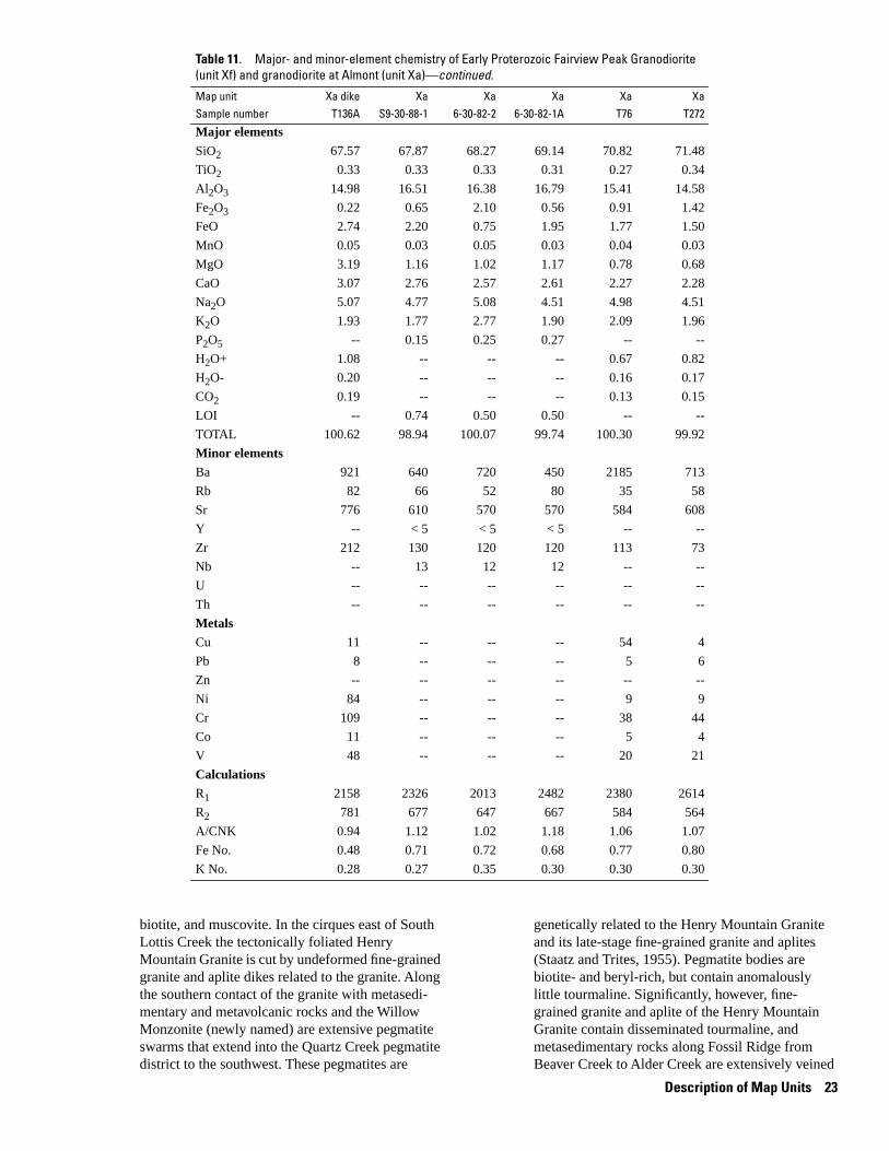
-- -- --
-- -- --
-- -- --
-- -- --
-- -- --
-- -- --
-- -- --
-- -- -- -- -- --
-- -- -- -- -- --
-- -- --
-- -- --
-- -- -- -- -- --
-- -- --
-- -- --
-- -- --
-- -- --
Table 11. Major- and minor-element chemistry of Early Proterozoic Fairview Peak Granodiorite (unit Xf) and granodiorite at Almont (unit Xa)—continued.
Map unit Xa dike Xa Xa Xa Xa Xa Sample number T136A S9-30-88-1 6-30-82-2 6-30-82-1A T76 T272
Major elements
SiO2
TiO2
Al2O3
Fe2O3
FeO
MnO
MgO
CaO
Na2O
K2O
P2O5
H2O+
H2O-
CO2
LOI
TOTAL
Minor elements
Ba
Rb
Sr
Y
Zr
Nb
U
Th
Metals
Cu
Pb
Zn
Ni
Cr
Co
V
Calculations
R1
R2
A/CNK
Fe No.
K No.
67.57 67.87 68.27 69.14 70.82 71.48
0.33 0.33 0.33 0.31 0.27 0.34
14.98 16.51 16.38 16.79 15.41 14.58
0.22 0.65 2.10 0.56 0.91 1.42
2.74 2.20 0.75 1.95 1.77 1.50
0.05 0.03 0.05 0.03 0.04 0.03
3.19 1.16 1.02 1.17 0.78 0.68
3.07 2.76 2.57 2.61 2.27 2.28
5.07 4.77 5.08 4.51 4.98 4.51
1.93 1.77 2.77 1.90 2.09 1.96
0.15 0.25 0.27
1.08 0.67 0.82
0.20 0.16 0.17
0.19 0.13 0.15
0.74 0.50 0.50
100.62 98.94 100.07 99.74 100.30 99.92
921 640 720 450 2185 713
82 66 52 80 35 58
776 610 570 570 584 608
< 5 < 5 < 5
212 130 120 120 113 73
13 12 12
11 54 4
8 5 6
84 9 9
109 38 44
11 5 4
48 20 21
2158 2326 2013 2482 2380 2614
781 677 647 667 584 564
0.94 1.12 1.02 1.18 1.06 1.07
0.48 0.71 0.72 0.68 0.77 0.80
0.28 0.27 0.35 0.30 0.30 0.30
biotite, and muscovite. In the cirques east of South Lottis Creek the tectonically foliated Henry Mountain Granite is cut by undeformed fine-grained granite and aplite dikes related to the granite. Along the southern contact of the granite with metasedimentary and metavolcanic rocks and the Willow Monzonite (newly named) are extensive pegmatite swarms that extend into the Quartz Creek pegmatite district to the southwest. These pegmatites are
genetically related to the Henry Mountain Granite and its late-stage fine-grained granite and aplites (Staatz and Trites, 1955). Pegmatite bodies are biotite- and beryl-rich, but contain anomalously little tourmaline. Significantly, however, fine-grained granite and aplite of the Henry Mountain Granite contain disseminated tourmaline, and metasedimentary rocks along Fossil Ridge from Beaver Creek to Alder Creek are extensively veined
Description of Map Units 23

and replaced by tourmaline. Apparently, most tourmaline crystallized in late-stage aplite bodies before final formation of the tourmaline-depleted pegmatite bodies in the Quartz Creek district.
The normal granite is pinkish tan and black, coarse grained, strongly porphyritic (large micro-cline phenocrysts > smaller quartz phenocrysts), undeformed to moderately flow foliated, and contains both biotite and muscovite. Abundant perthitic microcline phenocrysts as large as 1 × 1.8 cm and less numerous quartz phenocrysts as large as 1 cm are set in a groundmass of albite to sodic oligoclase (3 × 4 mm common, but as large as 4 × 6 mm) and minor myrmekite. All plagioclase is turbid and partially altered to sericite and muscovite, both of which are preferentially aligned along twin planes. Biotite and muscovite constitute most of the interstitial material and are present randomly throughout the granite, but more commonly in mafic clots. The clots are as large as 3 × 5 mm and contain biotite > muscovite >> apatite > ilmenite/magnetite, allanite overgrown by epidote, and zircon.
Average modal compositions of the granite are difficult to estimate because of its coarse grain size and porphyritic texture, but probably average micro-cline (32%), quartz (28%), albite and sodic oligoclase (18%), biotite (12%), muscovite (8%), magnetite and ilmenite (1.4%), apatite (0.5%), and trace amounts of zircon, allanite, and epidote.
A border phase is preserved locally on the south-east shoulder of Henry Mountain and on the divide that separates Crystal Creek and Beaver Creek in T. 51 N., R. 3 E., sec. 12. Conspicuously lacking in the border phase are the large perthitic microcline phenocrysts. Phenocrysts of unstrained to recrystallized quartz (6 × 10 mm) and plagioclase (3 × 5 mm) replaced by fine-grained muscovite are set in a groundmass of fine-grained (0.11 × 1.2 mm) quartz, albite(?), and microcline. Muscovite is throughout the groundmass as fine-grained, individual grains (0.3 × 0.4 mm), mats of grains, and as larger phenocrysts (1.8 × 3.0 mm). Minor biotite phenocrysts (0.3 × 0.6 mm) are disseminated throughout the granite and are spatially associated with minor apatite and traces of zircon. Pink garnet (0.3 to 0.6 mm) is conspicuous in most border phases.
Average modal composition of the border phase is 40% phenocrysts that consist of quartz (28%), plagioclase (10%), and microcline (2%). The remaining 60% of the rock is groundmass consisting of 35– 40% quartz, 25–30% microcline, 25% albite(?), 8% muscovite, 1% biotite, 0.25% garnet, and trace amounts of apatite, zircon, and opaque minerals.
Fine-grained aplitic granite and aplite dikes are light tan, equigranular, leucocratic, and are muscovite-rich. Fine-grained granite and aplite contain quartz and sodic oligoclase to albite and much lesser amounts of microcline. Muscovite is interstitial to
all grains and is present as sparse phenocrysts as large as 1 mm. Biotite is much less abundant than muscovite. Minor apatite is present. Characteristically the fine-grained granite and aplite contain trace amounts of tourmaline.
Fine-grained granite and aplite average quartz (40–50%), albite (15–25%), microcline (8–16%), muscovite (20%), biotite (0.5%), magnetite (0.1%), and traces of chlorite and tourmaline.
Chemically the unit is an alkali-calcic to calcalkalic granite that is strongly peraluminous, and has no discernible alkali or iron enrichment (fig. 9). Samples described as border phases are not appreciably more mafic than most of the granodiorite. Aplites are strongly calcic because of depletion of alkali elements, peraluminous because of enriched concentrations of muscovite, and Mg rich. For a rock that contains so much potassium feldspar, the granodiorite and granite are characterized by moderate to high concentrations of Y (25–55 ppm) and low concentrations of Ba (many < 550 ppm; table 12). Chemistry of the unit overlaps that of the Henry Mountain Granite in the Sawatch Range (fig. 9) and east of the Arkansas River (Fridrich and others, 1998), but is, on average, more chemically evolved in the Fossil Ridge area.
Early Proterozoic age assignment is based on observation that minor parts of the granite are affected by regional foliation, economically important pegmatite deposits that are genetically related to the granite, and published and unpublished Rb-Sr and U-Th-Pb geochronology studies. In a pioneering study of radioactive minerals from the Quartz Creek pegmatite district, Aldrich and others (1956) analyzed zircon from their Quartz Creek granite at Indian Head (T. 49 N., R. 3 E., sec. 4., north-central part), which is the Henry Mountain Granite of this report, and determined a 207Pb/206Pb zircon date of 1540 Ma. Numerous Rb-Sr dates of 1600–1800 Ma were determined for lepidolite and microcline from pegmatite bodies in the district and biotite from the Henry Mountain Granite. Sample #CO-20 of Wetherill and Bickford (1965) from the granite at Indian Head has three Rb-Sr whole-rock analyses which defined a minimum age of 1600 Ma if an initial Sr ratio of 0.706 was assumed. Bickford and Board-man (1984) and Bickford and others (1989b) report a U-Pb upper intercept age of 1701 + 10 Ma for zircon from the granite at Indian Head, which they call the granite of Wood Gulch (M.E. Bickford, oral commun., 1990). This age of 1701 Ma is in agreement with a 207Pb/206Pb date of 1693 Ma from one fraction of zircon from sample #8-12-82-2 along the Taylor River in T. 15 S., R. 84 W., Sec. 24 (Ed DeWitt and R.E. Zartman, unpub. data, 1990)
Xw Willow Monzonite (Early Proterozoic)—Named herein for exposures at its type area along and northeast of Willow Creek, T. 50 N., R. 3 E., secs. 9 and 10,
24 Geologic and Aeromagnetic Maps, Fossil Ridge Area and Vicinity, Gunnison County, Colorado

-- --
-- -- -- -- -- --
-- --
-- -- --
-- -- --
-- -- --
-- -- -- -- --
--
--
--
-- -- --
-- -- --
-- -- --
-- -- -- -- --
-- -- -- -- -- -- -- --
-- -- -- -- -- -- -- --
-- -- -- -- -- -- -- --
Table 12. Major- and minor-element chemistry of Early Proterozoic Henry Mountain Granite (unit Xh) from the Fossil Ridge and surrounding area, Gunnison County, Colorado.
[Major-element oxides (in weight percent) for samples collected in this study (7- and 8- series) determined by X-ray fluorescence by A.J. Bartel, K.C. Stewart, and J.E. Taggart; H2O+ and H2O- determined by weight loss by H. Neiman and J. Ryder; CO2 determined by coulometric titration by H. Neiman and J. Ryder; FeO determined by potentiometric titration by H. Neiman and J. Ryder; Minor elements (in ppm) determined by energy-dispersive X-ray fluorescence by Ross Yeoman and Ed DeWitt; U and Th determined by delayed neutron activation by J. Storey, S. Danahey, R.B. Vaughn, and M. Coughlin; major elements for sample 7-2-82-2 determined by X-ray fluorescence by Bondar-Clegg Laboratories, Vancouver, British Columbia, courtesy of Magmachem Exploration, Seattle, WA; FetO3, total iron as Fe2O3; LOI, loss on ignition; --, not determined or calculated; R1, calculated values for R1R2 plot; R2, calculated values for R1R2; A/CNK, calculated values for SiO2 versus A/CNK plot; Fe No., calculated values for (FeO + 0.89Fe2O3)/(FeO + 0.89Fe2O3 + MgO) versus SiO2 plot; K No., calculated values for K2O/(K2O + Na2O) versus SiO2 plot]
Part of unit main main main main main aplite border border Sample number 8-12-82-2 7-15-82-1 7-10-82-5 8-11-82-3 8-8-82-1 7-1-82-3 7-2-82-2 8-11-82-4
Major elements
SiO2 70.20 70.50 70.60 70.90 73.60 78.20 74.70 75.00
TiO2 0.46 0.59 0.37 0.32 0.23 0.04 0.07 0.16
Al2O3 14.60 14.10 14.50 14.60 13.60 12.90 14.10 13.20
Fe2O3 0.80 1.23 0.78 0.61 0.56 1.55
FetO3 2.46 1.42
FeO 2.22 2.44 1.96 1.16 0.27 2.17
MnO 0.07 0.08 0.06 0.05 0.05 0.06 0.10 0.04
MgO 0.72 0.84 0.73 0.57 0.44 0.42 0.14 0.29
CaO 1.50 2.03 1.34 1.07 1.09 0.96 0.56 0.62
Na2O 2.44 2.37 2.57 2.23 2.48 2.47 3.64 1.78
K2O 4.97 3.79 4.62 5.29 4.40 1.97 4.37 4.71
P2O5 0.27 0.32 0.22 0.26 0.23 0.12 0.13 0.26
H2O+ 0.91 1.02 0.91 0.96 0.95
H2O- 0.01 0.01 0.02 0.01 0.09
CO2 0.03 0.06 0.01 0.18 0.01
LOI 1.16 0.60 1.11
TOTAL 99.20 99.38 98.69 98.91 99.04 99.02 102.13 98.59
Minor elements
Ba 829 534 577 690 274 277 110
Rb 246 187 227 252 279 116 186 330
Sr 144 129 120 105 70 211 200 55
Y 45 56 36 26 34 16 53 31
Zr 249 290 163 188 131 24 342 89
Nb 21 22 19 23 22 11 24 20
U 0.51 3.05 3.35 1.74 2.69 1.20 2.54
Th 2.00 23.40 10.50 9.03 12.10 < 2.1 4.80
Metals
Cu 63 22 38 42 99
Pb 43 15 17 32 20
Zn 81 94 64 66 102
Ni 57 71 34
Cr
Co
V
Calculations
R1 2553 2853 2625 2623 2938 3846 2559 3221
R2 483 535 464 429 405 377 343 340
A/CNK 1.21 1.21 1.25 1.29 1.26 1.63 1.20 1.44
Fe No. 0.80 0.81 0.78 0.80 0.80 0.65 0.96 0.82
K No. 0.67 0.62 0.64 0.70 0.64 0.44 0.55 0.73
Description of Map Units 25

Figure 9. Summary geochemical diagrams for the Henry Mountain Granite (unit Xh) and the Willow Monzonite (unit Xw). Rock names listed in figure 4. Data from this study and from Earley (1987). Position of samples that plot off the diagrams shown by arrows. Refer to tables 12 and 13 for analytical data.(A) R1R2 major element classification diagram (De la Roche and others, 1980). Fields of alkalinity modified slightly from those in DeWitt (1989) based on Fridrich and others (1998).(B) Alumina saturation diagram (SiO2 versus A/CNK). A, molar Al2O3; C, molar CaO; N, molar Na2O; K, molar K2O.(C) Alkali classification diagram (K2O/(K2O + Na2O) versus SiO2). Field boundaries from this study.(D) Iron enrichment classification diagram (FeO + 0.89*Fe2O3)/(FeO + 0.89*Fe2O3 + MgO) versus SiO2. Field boundaries slightly modified from those in DeWitt (1989) based on Fridrich and others (1998).
south of Fossil Ridge. Pluton is a northeasterly elongate body, about 4 km wide and 8 km long, that crops out between Alder Creek and Quartz Creek, south of Fossil Ridge. About 75% of the pluton is within the map area; 25% extends to the southwest, into the Quartz Creek pegmatite district where it is cut off by the coarse-grained granite (unit gr of Staatz and Trites, 1955) that is equivalent to the Henry Mountain Granite (unit Xh). Pluton equivalent to the hornblende-biotite syenite and pyroxene monzonite of Crawford and Worcester (1916), to unnamed granite-syenite-monzonite (DeWitt and others, 1985), and to pyroxene monzonite and hornblende monzonite of Earley (1987). Body consists of older, mafic border phase of dark-greenish-gray to black, medium- to coarse-grained, undeformed monzogabbro to gabbro-diorite (stippled on geologic map, unit Xwg) exposed discontinuously on the east, north, and northwest sides of the pluton.
Younger, tan to grayish-green, medium-grained, porphyritic (plagioclase phenocrysts), undeformed felsic core phase of granodiorite (no stippled pat-tern) cuts off border phase on southeast side of the pluton and isolates a part of the border phase within the core on the northwest side of the pluton, but grades into the border phase to the north and north-east, as originally noted by Crawford and Worcester (1916). Granodiorite phase equivalent and continuous to the southeast with quartz monzonite (unit qm of Staatz and Trites, 1955) in the Quartz Creek pegmatite district. Red, feldspar-rich, iron-stained rocks termed syenite by Crawford and Worcester (1916) are restricted to northeast part of pluton. Feldspar in these iron-stained rocks is predominantly oligoclase, not microcline.
Monzonite to gabbro-diorite consists of subequal amounts of medium- to coarse-grained, turbid oligoclase (5 × 10 mm) and mafic clots of dark- to
26 Geologic and Aeromagnetic Maps, Fossil Ridge Area and Vicinity, Gunnison County, Colorado

medium-green actinolitic hornblende and poikilitic, brown biotite. Amphibole in mafic clots is a mixture of minor, early-formed hornblende and abundant, large crystals made up of a fine-grained mosaic of light-green to blue-green pleochroic actinolitic hornblende. The turbid nature of oligoclase is caused by fine-grained epidote and biotite grains. Sphene, ilmenite rimmed by sphene, and abundant apatite as much as 1 mm long are associated in the mafic clots. Minor epidote and trace zircon are also associated with the mafic clots. Fine- to medium-grained quartz, microcline, and myrmekite are interstitial to oligoclase and the mafic minerals. Craw-ford and Worcester (1916) and Earley (1987) noted minor orthopyroxene mantled by clinopyroxene in the most mafic rocks.
Granodiorite is porphyritic and consists of 40– 70% phenocrysts of medium- to coarse-grained, turbid oligoclase(?), clots of mafic minerals, and groundmass of oligoclase, quartz, and microcline. The turbid nature of plagioclase is due to very fine grained epidote and biotite. Mafic clots are composed of medium-grained hornblende and biotite that contain and overgrow euhedral sphene, ilmenite rimmed by sphene, abundant apatite, fine-grained epidote, and allanite rimmed by epidote. Ground-mass of the most felsic granodiorite is a mosaic of fine- to medium-grained, equigranular microcline, oligoclase, biotite, and quartz.
All rock types are alkali-calcic, metaluminous, sodic to very potassic, and average to very Mg rich (fig. 9). The unit is characterized by high Zr (155– 835 ppm) and average to high Ba (1,600–3,800 ppm) concentrations (table 13). No rocks of similar composition are known from the Sawatch Range or other mountain ranges in Central Colorado.
Early Proterozoic age assignment based on observation that pegmatite bodies related to the Henry Mountain Granite cut the pluton in the map area and on the fact that the Henry Mountain Granite in the Quartz Creek pegmatite district (Staatz and Trites, 1955) to the southwest of the map area cuts the felsic core phase of the pluton. The Taylor River Granite cuts the pluton on the north and northeast
Xc Crystal Gabbro (Early Proterozoic)—Named herein for exposures at its type area along the upper reaches of Crystal Creek, both on the western side of the creek and on the southwestern face of Henry Mountain in T. 51 N., R. 3 E., sec. 17, and in T. 51 N., R. 3 E., sec. 15, respectively. In these localities the gabbro is intruded by the Henry Mountain Granite. To the south, on Fossil Ridge, gabbro intrudes Early Proterozoic metasedimentary rocks. Equivalent to quartz diorite of Crawford and Worcester (1916) and unnamed diorite of DeWitt and others (1985). Includes part of quartz diorite of Zech (1988).
Gabbro is dark gray to black and tan, medium grained, equigranular, and massive to poorly
foliated. Minor porphyroblasts of potassium feldspar are present in gabbro where it has been intruded by the Henry Mountain Granite. Distinctive, translucent, light-brown calcic andesine (0.1 × 0.4 mm to 0.4 × 2.0 mm), large (2 × 2 mm) crystals of amphibole composed of mass of finer grained (0.15 × 0.25 mm) actinolitic hornblende and hornblende, and biotite (averages 1 mm across, but as large as 0.6 × 5.0 mm) are set in a matrix of clear calcic andesine and quartz. Darkening of plagioclase grains may be a consequence of submicroscopic, iron-rich colloidal particles. Acicular apatite grains as long as 0.2 mm, sphene as ragged over-growths on ilmenite(?) and magnetite(?), and allanite overgrown by epidote are trace constituents. Epidote-group minerals and minor calcite are trace components.
Average modal composition of typical gabbro is 35–40% calcic andesine, 25–40% amphibole, 10– 15% biotite, 5–8 % quartz, 0.2–11% magnetite and ilmenite, 0.8% apatite, 0.4% sphene, and traces of epidote-group minerals, chlorite, and calcite. Potassium feldspar may be present, but was not identified.
The unit ranges from monzogabbro to gabbrodiorite, is alkali-calcic, metaluminous, very potassic, and very Fe to very Mg rich (fig. 7). One sample of gabbro has high concentrations of barium (2,600 ppm), strontium (>1,000 ppm), and zirconium (350 ppm; table 4), similar to olivine gabbro dikes of unit YXgb. Some samples are similar in chemistry to metagabbro bodies in the Almont area (Urbani, 1971, Urbani and Blackburn, 1974), but exact correlation does not appear to be possible.
Early Proterozoic age assignment based on observation that body is intruded by the Henry Mountain Granite
Xb Granodiorite of Broncho Mountain (Early Protero�zoic)—Small deformed mass of granodiorite on south and east sides of Broncho Mountain near the headwaters of Gold Creek. Granodiorite intrudes Early Proterozoic metasedimentary rocks and is cut by granite of Taylor River. Equivalent to the now obsolete Broncho Mountain granite of Crawford and Worcester (1916). Included as part of unit YXg by Tweto (1979). May be genetically related to mafic part of Henry Mountain Granite or felsic, pink, plagioclase-rich phase of Willow Monzonite.
Granodiorite is dark gray and pink, medium grained, well foliated, and characteristically biotite rich. Sigmoidal aggregates of strained and recrystallized quartz (as much as 2 × 4 mm) and aggregates of biotite (as much as 1 × 4 mm) define the foliation in the rock. A groundmass of fine-grained (0.1 × 0.2 mm), anhedral quartz, subhedral microcline and biotite, and minor plagioclase phenocrysts(?) (as much as 0.4 × 0.6 mm) is
Description of Map Units 27

-- -- -- -- --
-- -- -- -- -- -- --
-- -- -- -- --
-- --
-- --
-- -- -- -- -- -- --
-- -- -- -- -- -- --
-- -- -- -- --
-- -- -- -- -- -- --
-- -- -- -- --
-- -- -- -- --
-- -- -- -- --
-- -- -- -- -- -- --
-- -- -- -- --
Table 13. Major- and minor-element chemistry of Early Proterozoic Willow Monzonite (unit Xw) from the Fossil Ridge and surrounding area, Gunnison County, Colorado.
[major elements for samples 9-2-88-3, 9-2-88-11, 9-2-88-6, 9-2-88-7, and 9-2-88-13 determined by X-ray fluorescence by Bondar-Clegg Laboratories, Vancouver, British Columbia, courtesy of Magmachem Exploration, Seattle, WA; FetO3, total iron as Fe2O3; LOI, loss on ignition; --, not determined or calculated; R1, calculated values for R1R2 plot; R2, calculated values for R1R2; A/CNK, calculated values for SiO2 versus A/CNK plot; Fe No., calculated values for (FeO + 0.89Fe2O3)/(FeO + 0.89Fe2O3 + MgO) versus SiO2 plot; K No., calculated values for K2O/(K2O + Na2O) versus SiO2 plot; see Earley (1987) for analytical techniques for samples of gabbro beginning with 13 or 66]
Sample number 9-2-88-3 66G 9-2-88-11 13 9-2-88-6 9-2-88-7 9-2-88-13
Major elements
SiO2 53.41 53.50 54.66 54.80 55.13 60.36 66.43
TiO2 1.52 1.69 1.33 1.24 1.49 1.11 0.57
Al2O3 16.24 15.20 15.61 14.77 16.35 16.24 16.37
Fe2O3 3.53 3.20 3.05 2.88 2.57 3.12 1.56
FeO 4.30 5.27 5.15 4.30 5.40 2.30 1.85
MnO 0.11 0.12 0.12 0.10 0.13 0.07 0.07
MgO 4.55 4.37 5.24 5.22 4.74 1.97 1.23
CaO 5.75 6.51 6.07 5.53 6.30 3.66 2.50
Na2O 2.75 3.02 2.70 2.83 2.92 3.14 3.46
K2O 3.65 3.85 3.84 5.18 3.68 5.23 4.46
P2O5 0.85 0.64 0.78 0.70 0.77 0.43 0.32
H2O+ 0.75 0.85
H2O-
CO2 0.02 0.01
LOI 1.00 0.80 < 0.01 0.80 0.60
TOTAL 97.66 98.14 99.35 98.41 99.48 98.43 99.42
Minor elements
Ba 3800 3200 3000 3720 2500 1600 1600
Rb 74 86 87 136 73 200 210
Sr 900 1137 895 1435 900 600 500
Y 16 29 28 31 18 53 30
Zr 155 215 260 470 200 835 255
Nb 10 15 15 34 31
U
Th
Metals
Cu 132 39
Pb
Zn 99 87
Ni 116 119
Cr 128 179
Co
V 195 138
Calculations
R1 1481 1321 1530 1211 1522 1512 2048
R2 1159 1211 1216 1140 1230 808 650
A/CNK 0.86 0.73 0.80 0.73 0.81 0.93 1.09
Fe No. 0.62 0.65 0.60 0.57 0.62 0.72 0.73
K No. 0.57 0.56 0.59 0.65 0.56 0.62 0.56
between the biotite-rich folia. Within the biotite-rich abundant apatite, traces of zircon, and muscovite clusters is abundant allanite rimmed by epidote, (0.1 × 0.2 mm) that is concentrated near the mar-minor but conspicuous fine-grained sphene that gins of biotite-rich clots. Tourmaline crystals were apparently nucleated preferentially on biotite, noted in one biotite-rich band. Minerals within the
28 Geologic and Aeromagnetic Maps, Fossil Ridge Area and Vicinity, Gunnison County, Colorado

biotite-rich bands are very similar to those in the Henry Mountain Granite.
Average modal composition is approximately 30% biotite, 2–25% microcline, 20–25% quartz, 10–15% plagioclase, 5% muscovite, 1–2% apatite, 1–2% allanite rimmed by epidote, and traces of sphene, epidote, zircon, and opaque minerals.
The granodiorite is alkali-calcic, mildly peraluminous, average to very potassic, very Mg rich (fig. 10), and has moderately high concentrations of Sr (table 14).
Early Proterozoic age assignment based on pre-tectonic nature of body and chemical similarity to mafic parts of Henry Mountain Granite and felsic, pink, plagioclase-rich phase of Willow Monzonite
Xr Roosevelt Granite (Early Proterozoic)—Named herein for exposures at its type area along Quartz Creek between Pitkin and Ohio City, especially outcrops along Roosevelt Gulch in T. 50 N., R. 4 E., secs. 17 (this map) and 20 (south of this map). Granite forms northwesterly elongate pluton that averages 3 km wide and 10 km long. Contacts with country rocks
are sharp. Minor dikes and sills of granite present in wall rocks as far as 1 km from pluton boundary. Included in granite unit of Crawford and Worcester (1916) and unit Xg of Tweto (1979).
Granite is light tan, fine to medium grained, slightly porphyritic (sodic oligoclase phenocrysts), and massive to well foliated. Intensely foliated granite restricted to discontinuous zones of high strain that strike north to north-northeast, parallel to regional foliation. Emplacement of the granite pre-dates development of regional foliation, but much of granite crops out in a zone of low strain and hence, is relatively unfoliated.
Sodic oligoclase phenocrysts (average 0.7 × 1.5 mm, but as large as 0.8 × 2.5 mm) are turbid and partly replaced by sericite and muscovite as much as 0.1 mm in diameter. Groundmass predominated by quartz (0.1–0.2 mm diameter) and minor microcline. Greenish-brown biotite is the only mafic mineral and is randomly distributed throughout the granite. Epidote is locally present as breakdown product of plagioclase and as overgrowths on
Figure 10. Summary geochemical diagrams for the granodiorite of Broncho Mountain (unit Xb) and the Roosevelt Granite (unit Xr). Rock names listed in figure 4. Data from this study. Refer to table 14 for analytical data.(A) R1R2 major element classification diagram (De la Roche and others, 1980). Fields of alkalinity modified slightly from those in DeWitt (1989) based on Fridrich and others (1998).(B) Alumina saturation diagram (SiO2 versus A/CNK). A, molar Al2O3; C, molar CaO; N, molar Na2O; K, molar K2O.(C) Alkali classification diagram (K2O/(K2O + Na2O) versus SiO2). Field boundaries from this study.(D) Iron enrichment classification diagram (FeO + 0.89*Fe2O3)/(FeO + 0.89*Fe2O3 + MgO) versus SiO2. Field boundaries slightly modified from those in DeWitt (1989) based on Fridrich and others (1998).
Description of Map Units 29

--
-- -- -- -- -- -- --
--
-- -- -- -- -- -- --
-- -- -- -- -- -- --
-- -- -- -- -- -- --
--
-- -- -- -- -- --
-- -- -- -- -- --
Table 14. Major- and minor-element chemistry of Early Proterozoic granodiorite of Broncho Mountain (unit Xb) and Roosevelt Granite (unit Xr) from the Fossil Ridge and surrounding area, Gunnison County, Colorado.
[Major-element oxides (in weight percent) for samples collected in this study (8- series) determined by X-ray fluorescence by A.J. Bartel, K.C. Stewart, and J.E. Taggart; H2O+ and H2O- determined by weight loss by H. Neiman and J. Ryder; CO2 determined by coulometric titration by H. Neiman and J. Ryder; FeO determined by potentiometric titration by H. Neiman and J. Ryder; Minor elements (in ppm) determined by energy-dispersive X-ray fluorescence by Ross Yeoman and Ed DeWitt; U and Th determined by delayed neutron activation by J. Storey, S. Danahey, R.B. Vaughn, and M. Coughlin; major elements for sample BM2, BM1, 8-31-83-5, 8-31-83-7, 8-30-83-5, and 8-30-83-6 determined by X-ray fluorescence by Bondar-Clegg Laboratories, Vancouver, British Columbia, courtesy of Magmachem Exploration, Seattle, WA; FetO3, total iron as Fe2O3; LOI, loss on ignition; --, not determined or calculated; R1, calculated values for R1R2 plot; R2, calculated values for R1R2; A/CNK, calculated values for SiO2 versus A/CNK plot; Fe No., calculated values for (FeO + 0.89Fe2O3)/(FeO + 0.89Fe2O3 + MgO) versus SiO2 plot; K No., calculated values for K2O/(K2O + Na2O) versus SiO2 plot]
Map unit Xb Xb Xr Xr Xr Xr Xr Xr Sample number BM2 BM1 8-31-83-5 8-13-82-2 8-31-83-7 8-30-83-5 8-30-83-6 8-30-83-8
mineralized mineralized mineralized
Major elements
SiO2
TiO2
Al2O3
Fe2O3
FetO3
FeO
MnO
MgO
CaO
Na2O
K2O
P2O5
H2O+
H2O-
CO2
LOI
TOTAL
Minor elements
Ba
Rb
Sr
Y
Zr
Nb
U
Th
Calculations
R1
R2
A/CNK
Fe No.
K No.
66.17 67.54 73.25 74.80 76.54 76.94 77.17 77.60
0.58 0.51 0.19 0.14 0.16 0.06 0.05 0.05
14.98 15.49 13.12 13.20 12.52 12.07 12.21 12.10
1.44 1.42 1.01 0.87 1.23 0.79 0.32
0.91
2.40 2.30 1.20 1.08 0.85 0.15 0.50
0.09 0.10 0.02 0.02 0.03 0.03 0.01 0.02
2.59 2.35 0.80 0.33 0.34 0.13 0.79 0.36
2.10 2.24 0.71 1.32 1.03 0.68 0.23 0.44
2.70 3.30 3.14 4.86 4.36 3.81 4.45 5.60
5.09 4.37 4.07 1.42 2.62 4.48 1.46 0.88
0.47 0.50 0.18 0.05 0.22 0.13 0.11 0.05
0.51
0.02
0.10
0.60 0.90 0.90 0.60 0.70 0.70 0.60
99.21 101.02 98.59 98.71 100.50 99.97 98.00 98.60
2000 1800 1400 766 760 80 < 20 260
195 160 69 31 63 180 72 38
690 565 54 131 99 < 5 10 20
18 15 < 5 25 15 145 125 128
285 280 175 152 170 120 170 156
33 36 17 13 14 17 41 52
2.69 7.51
6.59 14.10
2140 2192 2748 2867 2877 2698 3193 2948
647 660 373 417 373 316 303 302
1.09 1.09 1.21 1.11 1.06 0.98 1.31 1.11
0.59 0.60 0.72 0.85 0.85 0.87 0.50 0.69
0.65 0.57 0.56 0.23 0.38 0.54 0.25 0.14
alanite. Ilmenite, zircon, and apatite are trace have variable Fe/Mg ratios (fig. 10). Samples least constituents. affected by hydrothermal alteration related to gold
Average modal composition of typical granite is deposits in the Gold Creek district are the most Fe-45% sodic oligoclase, 42% quartz, 8% microcline, rich (fig. 10D). The granite is distinguished from 3.7% biotite, 0.2 % ilmenite, 0.1% epidote, and other Early Proterozoic plutonic units by its high traces of zircon, apatite, allanite, and minor calcite. Na2O/K2O ratio (in unaltered rocks > 2) and Sr con-
Fresh samples of the granite are alkali-calcic to centrations less than 55 ppm (table 14). Very high Y calc-alkalic, strongly peraluminous, very sodic, and concentrations in samples from the Raymond and
30 Geologic and Aeromagnetic Maps, Fossil Ridge Area and Vicinity, Gunnison County, Colorado

Carter mines (Samples 8-30-83-5, 8-30-83-6, and 8-30-83-8, table 10) reflect hydrothermal alteration related to gold mineralization (Crawford and Worcester, 1916; DeWitt and others, 1985).
Early Proterozoic age based on pre-tectonic structural relations, published Rb-Sr geochronology and unpublished U-Th-Pb geochronology of this study. Sample #CO-61 of Wetherill and Bickford (1965) is from the Roosevelt Granite. Two Rb-Sr whole-rock analyses suggest a minimum age of 1600 Ma if 0.706 is assumed for Sri. One zircon fraction from sample #8-13-82-2 of the Roosevelt Granite (located just south of this map in T. 50 N., R. 4 E., Sec. 20, center) has a 207Pb/206Pb date of 1720 Ma (Ed DeWitt and R.E. Zartman, unpub. data, 1990).
Xs Metasedimentary rocks (Early Proterozoic)—Quartzmuscovite-plagioclase-chlorite schist, quartz-muscovite-biotite-chlorite schist, quartz-muscovitecordierite-biotite-chlorite schist, quartz-rich metachert or quartzite, quartz-muscovite-plagioclase-cordierite-sillimanite schist, and quartzplagioclase-biotite-chlorite-andalusite-staurolite schist (all containing opaque minerals, apatite, and zircon) that crop out predominantly on Fossil Ridge and to the north, west, and southwest. Another, fairly extensive body east of Pitkin. Cordierite-bearing schist most widespread; andalusite- and staurolite-rich schist restricted to small outcrops near Boulder Gulch and Bear Gulch, and area west and south of Ohio City (Usdansky, 1981); sillimaniterich schist restricted to western Fossil Ridge, near contact with Henry Mountain Granite. Veins and thin replacement lenses of tourmaline cut quartzmuscovite-plagioclase-cordierite schist on western Fossil Ridge.
Protoliths include graywacke, siltstone, Mg-rich shale, and siliceous volcaniclastic rocks. Depositional contact with older mafic metavolcanic rocks well preserved in cirque wall on south side of Lower Lamphier Lake (T. 51 N., R. 3 E., sec. 24); trace of contact is crudely parallel to the Boulder fault to the southwest. Facing indicators such as graded beds and crossbeds show top-to-the-northwest in much of the metasedimentary unit. Metamorphosed graywacke predominates along Fossil Ridge and to the west. Metamorphosed Mg-rich shale and silt-stone abundant from Mill Lake to Broncho Mountain. Quartzite or metachert restricted to thin outcrops on west side of Gold Creek, in T. 50 N., R. 3 E., secs. 2 and 14. Metamorphosed siltstone and shale common in area east of Pitkin. Includes quartz-mica schist (Dings and Robinson, 1957), part of quartz-sericite schist and quartzite unit of Earley (1987), and part of unit called gneisses and schist by Crawford and Worcester (1916). Metagraywacke and metamorphosed siltstone similar in mineralogy and composition to metasedimentary units in the Almont area (Navarro, 1971; Navarro and Black-burn, 1974).
Fine-grained quartz (0.3 mm), muscovite (0.05 × 0.3 mm diameter), and plagioclase (0.1 × 0.5 mm) form matrix to porphyroblasts of biotite (0.6 mm diameter), chlorite (0.2–0.8 mm), cordierite (2 × 4 mm to as large as 1 × 4 cm), staurolite and andalusite (0.8 × 1.5 mm to 2 × 3 cm), and feathery, fine-grained mats of sillimanite (0.02 × 0.3 mm across). Cordierite commonly contains abundant inclusions of quartz and muscovite and is normally retrograded to fine-grained masses of quartz and muscovite, medium-grained masses of pale-green chlorite, or single crystals of biotite.
Early Proterozoic age based on unit being intruded by the 1700-Ma Henry Mountain Granite and the approximately 1650-Ma Fairview Peak Granodiorite and on the fact that the unit is depositionally on top of mafic and felsic metavolcanic rocks that have U-Pb zircon dates of 1745 to 1770 Ma (see discussion below in section on felsic metavolcanic rocks)
Xgb Metagabbro (Early Proterozoic)—Sills, hypabyssal intrusive masses, and small plugs(?) that intrude Early Proterozoic metavolcanic and metasedimentary rocks on either side of Gold Creek. Bodies extend south of the map, across Quartz Creek, and into the Revenue mine area (Horlacher, 1987). Equivalent to diorite of Crawford and Worcester (1916). Includes part of hornblende plagioclase amphibolite (unit HPa) and hornblendite amphibolite (unit Ha) of Earley (1987) and hornblende diorite of Zech (1988). Where relations are obscured by vegetation, some metagabbro bodies may be included in mafic metavolcanic rocks (unit Xmv), below. Cumulate-textured bodies most abundant on south slope of Sheep Mountain and extending to Boulder Gulch, and on the eastern side of the valley of the headwaters of Comanche Creek.
Metagabbro is dark greenish black, fine to medium grained, equigranular to slightly porphyritic, and massive to well foliated. Relict phenocrysts of plagioclase, ophitic and cumulate textures, and homogeneous composition indicate gabbro protolith. Discordant intrusive contacts and chemical composition suggests metagabbro is younger, more mafic, and less alkali rich than mafic metavolcanic rocks of unit Xmv.
Non-cumulate metagabbro contains andesine to labradorite relict phenocrysts (0.3–2.0 mm) and hornblende (0.2–0.5 mm) set in a matrix of finer grained andesine and minor quartz. Ilmenite, apatite, and minor biotite and epidote-group minerals are noted, as well as trace amounts of calcite and sphene. Cumulate-textured metagabbro contains actinolite instead of hornblende, fewer plagioclase phenocrysts, and less biotite and much more chlorite. Magnesium-rich varieties are actinolitechlorite schist.
Average modal composition of metagabbro is 35–45% andesine to labradorite, 35–50%
Description of Map Units 31

hornblende, 1–5% quartz, 2–4% ilmenite and minor magnetite, 0–3% biotite, 0.2% apatite, and trace to less than 2% of epidote-group minerals, calcite, and sphene.
Metagabbro ranges from an ultramafic rock to gabbro-norite, to olivine gabbro. The suite is metaluminous, with the most evolved alkalic samples having the highest Al2O3 concentrations (table 15), and hence having the highest A/CNK ratio (fig. 11B). The gabbroic rocks have no appreciable alkali enrichment and most are average to very Fe rich (fig. 11D). Most metagabbro bodies are more mafic than most of the mafic metavolcanic strata that they intrude (fig. 11A) The calcic nature of the gabbronorite bodies is probably related to slight accumulation of calcic plagioclase during crystal settling
Xfv Felsic metavolcanic rocks (Early Proterozoic)—Quartzplagioclase-muscovite-biotite-opaque-mineralchlorite schist that crops out on the south slopes of Sheep Mountain, east of Quartz Creek. Relict phenocrysts of albite and polygonal aggregates of quartz, in addition to possible flattened pumice shards and agglomeratic textures, indicate volcanic protolith, probably rhyolite to rhyodacite tuff. Includes part of quartz-feldspar schist and quartzmicrocline schist of Earley (1987).
Matrix of fine-grained quartz (0.06 to 0.1 mm diameter), muscovite (0.3 × 0.5 mm), and minor biotite (0.1 × 0.3 mm), opaque minerals, and chlorite and apatite surround phenocrysts and lenses of albite (0.4 × 0.9 mm) and quartz-rich material.
Average modal composition is 50–65% quartz, 10–20% albite, 8–12% muscovite, 2–4% opaque minerals, 3–5% biotite, and minor amounts of chlorite and apatite. Potassium feldspar was not recognized.
Early Proterozoic age assignment based on observation that map unit is stratigraphically beneath metasedimentary rocks discussed above that are intruded by the Henry Mountain Granite
Xiv Intermediate-composition metavolcanic and metased�imentary rocks (Early Proterozoic)—Heterogeneous mixture of quartz-plagioclase-biotitemuscovite schist, quartz-plagioclase-biotite-chlorite schist, plagioclase-quartz-biotite-hornblende-epidote schist, quartz-microcline-plagioclase-biotite-epidote schist, quartz-plagioclase-cordierite-anthophyllite schist, and quartz-plagioclase-gedrite-garnet-biotite schist (all containing opaque minerals, apatite, and minor zircon) that crop out extensively on the east side of Quartz Creek and to a lesser extent, on the west side. Cordierite- and orthoamphibole-rich rocks restricted to area along Quartz Creek, especially adjacent to amphibole-bearing rocks in mafic metavolcanic unit. Plagioclase- and microcline-rich units most numerous on southwest flank of Quartz Dome.
Protoliths include dacite flows and tuffs, intermediate-composition volcaniclastic rocks, and
Mg- and Al-rich sediments. Metamorphosed dacitic flows and tuffs abundant on southwest flank of Quartz Dome in T. 50 N., R. 31/2 E., sec. 13, and T. 50 N., R. 3 E., sec. 13, and extend south across Quartz Creek (Horlacher, 1987). Includes part of quartz-feldspar schist of Earley (1987), part of biotite gneiss of Usdansky (1981), and part of unit called gneiss and schist by Crawford and Worcester (1916).
Fine-grained quartz, muscovite, and plagioclase form matrix to relict phenocrysts of oligoclase (1–2 mm diameter) and minor aggregates of quartz (0.2–0.5 mm diameter) and biotite in metamorphosed dacite. Fine-grained quartz, muscovite, and minor biotite form matrix to much coarser grained (3–8 mm diameter), radiating splays of anthophyllite and gedrite and 3–10-mm-diameter porphyroblasts of cordierite in metamorphosed Mg- and Al-rich sediments and tuffaceous volcaniclastic rocks.
Early Proterozoic age assignment based on inter-bedded nature of these rocks with felsic metavolcanic rocks and by U-Pb zircon dating of similar rocks immediately south of the map area. Sample QCF of Bickford and others (1989b), which has a U-Pb zircon age of 1770 + 8 Ma, is from T. 50 N., R. 3 E., sec. 30 (approximate location) and is representative of much of the metamorphosed dacite in the unit
Xmv Mafic metavolcanic rocks (Early Proterozoic)— Amphibolite, quartz-plagioclase-biotitehornblende-cummingtonite schist, hornblendeepidote-plagioclase-quartz gneiss, epidote-plagioclase-diopside-hornblende-quartz gneiss, calcitehornblende-diopside-labradorite-quartz gneiss, diopside-epidote-sphene-calcite gneiss, microclinebiotite-hornblende-epidote gneiss, hornblendemicrocline-epidote-gneiss, and quartz-plagioclasehornblende-biotite-muscovite-calcite-epidote gneiss. Unit is predominantly amphibolite that crops out on both sides of Gold Creek. Smaller exposures of amphibolite in area northeast of Union Park and northeast of Cumberland Pass. Part of unit containing epidote, diopside, and garnet exposed on west side of Gold Creek, from near Sheep Mountain to near Ohio.
Protoliths include pillowed and vesicular basalt, calcareous mafic tuff, calcareous felsic tuff, and minor intrusive gabbro. Virtually unstrained metamorphosed pillowed basalt exposed in Comanche Gulch in T. 50 N., R. 3 E., secs. 2 and 3, in Boulder Gulch in T. 51 N., R. 3 E., sec. 36, and in upper plate of Tincup thrust northeast of Cumber-land Pass. Vesicular metamorphosed basalt exposed on southern slopes of Sheep Mountain in T. 51 N., R. 3 E., sec. 28. Includes parts of vesicular basaltic amphibolite, pillowed basaltic amphibolite, and calc-silicate gneiss of Earley (1987), part of banded gneiss and hornblende amphibolite of Usdansky (1981), part of unit called gneisses and schist of Crawford and
32 Geologic and Aeromagnetic Maps, Fossil Ridge Area and Vicinity, Gunnison County, Colorado

Figure 11. Summary geochemical diagrams for metagabbro and gabbro near Ohio (unit Xgb), mafic metavolcanic rocks near Ohio (Xmv), and mafic metavolcanic rocks south of Ohio, near the Revenue mine. Rock names listed in figure 7, with the addition of Alk Bas, alkali basalt; Ol Bas, olivine basalt; L Bas, lati-basalt; And-Bas, andesitic basalt; Lat, latite; T And, trachyandesite. Data from this study, Earley (1987), and Horlacher (1987). Refer to table 15 for analytical data.(A) R1R2 major element classification diagram (De la Roche and others, 1980). Fields of alkalinity modified slightly from those in DeWitt (1989) based on Fridrich and others (1998).(B) Alumina saturation diagram (SiO2 versus A/CNK). A, molar Al2O3; C, molar CaO; N, molar Na2O; K, molar K2O.(C) Alkali classification diagram (K2O/(K2O + Na2O) versus SiO2). Field boundaries from this study.(D) Iron enrichment classification diagram (FeO + 0.89*Fe2O3)/(FeO + 0.89*Fe2O3 + MgO) versus SiO2. Field boundaries slightly modified from those in DeWitt (1989) based on Fridrich and others (1998).
Worcester (1916), and quartz-hornblende schist and quartz-hornblende gneiss of Dings and Robin-son (1957).
Amphibolite (pillowed and vesicular metabasalt) contains fine-grained (0.2 × 0.4 mm diameter), untwinned plagioclase and minor quartz, coarser-grained (0.8 × 2.0 to 1 × 3 mm) relict phenocrysts of oligoclase to andesine, and hornblende (0.5 × 1.0 mm). Traces of biotite are noted, as are minor amounts of epidote. Accessories include fine-grained sphene, ilmenite, and apatite.
Average modal composition of amphibolite is 35–60% oligoclase to andesine, 30–50% hornblende, 10–15% quartz, 0.5–2% sphene, minor ilmenite, and traces of biotite, epidote, and chlorite.
Chemically, amphibolite is predominantly an alkali-calcic to calc-alkalic olivine basalt having high Al2O3 concentrations (table 15, fig. 11B). The
sequence has no appreciable alkali enrichment and ranges from average to very Fe rich (fig. 11), similar to the metagabbro bodies described above. Metamorphosed mafic rocks of similar major- and minor-element composition, but slightly more evolved (fig. 11A) are noted south of Quartz Creek (Horlacher, 1987), as are their spilitized equivalents. The amphibolite unit is characterized by slightly elevated strontium concentrations (>400 ppm, table 15).
Epidote-, diopside-, orthoamphibole-, garnet-, calcite-, and microcline-rich units (calcareous mafic tuff and felsic tuff protoliths contain 1–4-mm-thick bands of alternating feldspar-rich and feldspar-poor material within otherwise homogeneous amphibolite and amphibole schist. Bands of diopside-microcline-epidote, hornblende-epidote-sphene-diopside, epidote-biotite-muscovite-chlorite-sphene, biotite-
Description of Map Units 33

--
-- -- -- -- -- -- --
--
-- --
-- -- -- -- -- -- --
-- --
-- -- -- -- -- --
--
--
--
--
--
-- -- -- -- -- --
-- -- -- -- -- --
-- -- -- -- -- --
--
-- -- -- -- -- -- -- --
-- --
-- -- -- --
-- -- -- -- -- -- -- --
-- -- --
Table 15. Major- and minor-element chemistry of Early Proterozoic metagabbro (unit Xgb) and mafic metavolcanic rocks (unit Xmv) from the Fossil Ridge and surrounding area, Gunnison County, Colorado.
[Major-element oxides (in weight percent) for samples collected in this study (7- series) determined by X-ray fluorescence by A.J. Bartel, K.C. Stewart, and J.E. Taggart; H2O+ and H2O- determined by weight loss by H. Neiman and J. Ryder; CO2 determined by coulometric titration by H. Neiman and J. Ryder; FeO determined by potentiometric titration by H. Neiman and J. Ryder; Minor elements (in ppm) determined by energy-dispersive X-ray fluorescence by Ross Yeoman and Ed DeWitt; U and Th determined by delayed neutron activation by J. Storey, S. Danahey, R.B. Vaughn, and M. Coughlin; major elements for sample 7-22-82-3 determined by X-ray fluorescence by Bondar-Clegg Laboratories, Vancouver, British Columbia, courtesy of Magmachem Exploration, Seattle, WA; FetO3, total iron as Fe2O3; LOI, loss on ignition; --, not determined or calculated; R1, calculated values for R1R2 plot; R2, calculated values for R1R2; A/CNK, calculated values for SiO2 versus A/CNK plot; Fe No., calculated values for (FeO + 0.89Fe2O3)/(FeO + 0.89Fe2O3 + MgO) versus SiO2 plot; K No., calculated values for K2O/(K2O + Na2O) versus SiO2 plot; see Earley (1987) for analytical techniques for samples of metagabbro and metabasalt not beginning with 7-]
Map unit Xgb Xgb Xgb Xgb Xgb Xgb Xgb Xgb Sample number 37 K 29CM 7-20-82-2 7-22-82-3 7-21-82-1A 6 29CC
Major elements
SiO2 48.00 48.40 48.50 48.80 49.10 49.40 48.90 50.10
TiO2 0.71 0.38 0.46 1.25 0.79 1.75 0.97 2.01
Al2O3 10.28 10.20 14.36 17.50 13.97 13.90 15.40 12.79
Fe2O3 3.60 2.70 2.70 2.91 2.75 3.20 4.40
FetO3 16.80
FeO 11.40 7.30 9.00 9.18 9.21 8.30 11.80
MnO 0.25 0.21 0.20 0.19 0.22 0.24 0.20 0.30
MgO 12.37 13.92 8.86 5.16 8.07 4.84 6.75 5.21
CaO 10.78 12.30 11.88 9.75 11.34 8.74 11.65 9.08
Na2O 1.31 0.97 1.70 3.56 2.28 2.70 2.16 2.36
K2O 0.13 0.63 0.16 0.34 0.75 0.41 0.39 0.32
P2O5 0.09 0.20 0.06 0.18 0.15 0.30 0.14 0.28
H2O+ 1.97 2.32 1.67 1.23 1.38 1.33
H2O- 0.01
CO2 0.01 0.01 0.09 0.01 0.01 0.01
LOI 0.78 0.54
TOTAL 100.90 99.54 99.64 100.06 99.41 99.62 99.45 99.99
Minor elements
Ba 37 273 25 139 110 86 41
Rb 1 6 6 2 3 5 3
Sr 236 318 96 322 324 297 292
Y 12 11 14 21 26 19 30
Zr 37 29 17 56 84 50 76
Nb 6 7
U 2.38 0.48
Th 12.50 < 1.2
Metals
Cu 60 5 162 134 146 131 1
Pb
Zn 82 171 82 110 80 130
Ni 99 296 128 138 171 46 3
Cr 254 1330 218 86
Co
V 309 216 264 322 451
Calculations
R1 2275 2450 2258 1546 1939 1770 2062 1934
R2 1968 2206 1992 1642 1888 1448 1883 1481
A/CNK 0.47 0.41 0.59 0.73 0.56 0.67 0.61 0.62
Fe No. 0.54 0.41 0.56 0.70 0.59 0.76 0.62 0.75
K No. 0.09 0.39 0.09 0.09 0.25 0.13 0.15 0.12
34 Geologic and Aeromagnetic Maps, Fossil Ridge Area and Vicinity, Gunnison County, Colorado

-- -- -- -- -- --
-- -- -- -- -- --
-- -- -- -- -- --
-- -- -- -- -- --
-- -- -- -- -- --
-- -- -- -- -- --
-- -- -- -- -- --
-- -- -- -- -- --
Table 15. Major- and minor-element chemistry of Early Proterozoic metagabbro and metabasalt—continued.
Map unit Xmv Xmv Xmv Xmv Xmv Xmv Sample number 42 51G 53G 48G 42G 52G
Major elements
SiO2 47.00 48.40 48.40 49.50 49.60 53.10
TiO2 0.98 1.13 1.07 1.59 0.54 1.32
Al2O3 16.40 17.00 18.21 18.54 14.20 15.30
Fe2O3 2.70 2.50 2.90 3.20 3.20 5.20
FetO3
FeO 8.10 9.30 8.00 8.30 9.40 7.20
MnO 0.15 0.20 0.18 0.17 0.23 0.23
MgO 8.09 5.36 4.84 4.99 7.45 4.54
CaO 9.72 9.36 9.83 10.51 11.05 7.38
Na2O 2.71 3.72 3.26 2.33 2.88 3.64
K2O 1.68 0.62 0.60 0.54 0.28 0.62
P2O5 0.13 0.13 0.13 0.13 0.06 0.30
H2O+ 1.73 1.79 1.54 1.42 1.32 1.24
H2O-
CO2 0.01 0.74 0.54 0.16 0.01 0.01
LOI
TOTAL 99.40 100.25 99.50 101.38 100.22 100.08
Minor elements
Ba 230 77 127 61 53 201
Rb 20 5 11 8 3 13
Sr 98 516 485 289 172 432
Y 19 24 20 24 15 24
Zr 46 66 65 66 19 139
Nb
U
Th
Metals
Cu 140 60 134 114 109 147
Pb
Zn 77 93 85 96 78 125
Ni 325 38 35 33 75 24
Cr 403 43 41 46 60 25
Co
366 286 274 298 331 276
Calculations
R1 1457 1407 1602 1991 1859 1734
R2 1763 1601 1649 1736 1830 1315
A/CNK 0.69 0.72 0.76 0.79 0.57 0.76
Fe No. 0.57 0.68 0.69 0.69 0.62 0.72
K No. 0.38 0.14 0.16 0.19 0.09 0.15
muscovite-microcline, plagioclase-hornblende- gedrite-quartz-biotite, and calcite-diopside-hornbiotite-epidote, nearly pure diopside altered to actin- blende-labradorite-quartz are locally abundant. olite and quartz, microcline-sphene-epidote-actino- Diopside and epidote in layers are coarser grained lite-muscovite-hornblende, hornblende-quartz- (4 to 10 mm diameter) than all other minerals (0.1– biotite-plagioclase-cummingtonite, cummingtonite- 0.4 mm). Modal compositions vary tremendously,
Description of Map Units 35
V
from nearly monomineralic bands of epidote or diopside, to bands containing 40% microcline or 30% biotite.
Aeromagnetic Survey
In December 1981, High Life QEB covered the Fossil Ridge and surrounding area of this map with an airborne magnetic survey. East-west flight lines at a nominal spacing of one-half mile were tied with north-south lines spaced 4.5 mi apart. The survey was draped at an average elevation of 1,000 ft above the ground surface. A Geometrics 803 magnetometer having a sensitivity of 0.25 gammas was used for data acquisition at a sampling rate of one second. Data were reduced by the U.S. Geological Survey in Denver, Colo., and the reduced data were gridded at a spacing of 150 meters. Terrain corrections were applied where flight line elevations deviated significantly from 1,000 ft above ground. A total intensity magnetic field map and residual magnetic intensity map were produced from the data (U.S. Geological Survey, 1982). The total intensity map is used in this study.
Magnetic susceptibility measurements of rock units in the area were made using a Geoinstruments JH-8 meter (table 16). Natural outcrops, hand specimens, and slabbed rocks were measured, with no appreciable differences among the same rock collected from various sample localities. Paleozoic, Mesozoic, and Tertiary stratified rocks do not contain significant concentrations of magnetic minerals. The principal effect of such rocks is to slightly reduce the total magnetic intensity in proportion to the thickness of the rock units. All significant anomalies on the magnetic map are attributed to crystalline rocks.
Magnetic susceptibility measurements, in SI units, can be converted, approximately, to volume percent magnetite-equivalent by multiplying the SI measurements in table 16 by 100. Magnetite-equivalent units assume that magnetite is the only magnetic substance in the rock. A measurement of 2000 × 10-5 SI units is equivalent to 2 volume percent magnetite. An average magnetite concentration in most upper crustal rocks is between 1 and 2 volume percent. In simple terms, rocks with less than 1–2 volume percent magnetite will create magnetic lows; rocks with greater than 2 volume percent magnetite will create magnetic highs. Other features, such as magnetic inclination, dipoles, and orientation with respect to the earth’s magnetic field will cause variations from these generalizations.
Tertiary and Cretaceous Igneous Rocks
Rhyolite (unit Tr) and the porphyry of Green Mountain (unit Tgm) average less than 400 × 10-5 SI units (equivalent to less than 0.4 volume percent magnetite; table 16). Compared to many Proterozoic units, the rhyolitic rocks could be expected to cause magnetic lows. But, most bodies of rhyolite are too small to affect the magnetic field at the scale of this map. Also, many bodies have magnetite concentrations very similar to the Early Proterozoic Fairview Peak Granodiorite or Roosevelt Granite. A detailed, ground-based
magnetic survey of the Cumberland Pass area (Rosenlund, 1984, plate 8) shows a 1,500-gamma positive magnetic anomaly coincident with the southwestern edge of the porphyry of Green Mountain (unit Tgm) southwest of Cumber-land Pass in T. 51 N., R. 4 E., sec. 14. That anomaly is coincident with the -870 gamma closed contour of this map. Increased magnetite in the porphyry of Green Mountain is believed related to early stages of hydrothermal alteration (Rosenlund, 1984). The amount of magnetite in hydrothermally altered samples is indistinguishable from that in the Fairview Park Granodiorite (0.3 percent). Therefore, the porphyry cannot be readily distinguished from the Fairview Peak although the east-striking prong defined by the -850 to -900 gamma contour is roughly coincident with the surface exposure of the porphyry.
No magnetic susceptibility measurements were made on the tonalitic rocks (unit TKt), but the magnetite concentrations of 2–4 percent described by Rosenlund (1984) should contrast strongly with the surrounding Paleozoic strata and underlying Fairview Peak Granodiorite. No positive anomalies are noted over either the stock or sill. A detailed, ground-based magnetic survey of the Cumberland Pass area (Rosenlund, 1984, plate 8) also failed to reveal any positive magnetic anomalies associated with the stock, although adjacent skarn deposits rich in magnetite caused 700–1,000-gamma positive anomalies. If reversely polarized, the stock should have caused a magnetic low, but it did not (Rosenlund, 1984; plate 8). Perhaps the tonalitic rock is not stock-like in cross-section, but, rather, is a slightly inflated sill-like body.
The stock at Tincup (Jefferson, 1985), which has a slightly more mafic composition than the above tonalite stock and sill, contains only 2–3 volume percent magnetite, but surface outcrop of the stock is coincident with the -540 gamma contour of the steep-sided anomaly in the far northeastern part of map. The steep, southern gradient to the magnetic field suggests a steep-sided, magnetic intrusive rock at depth. A longer wavelength in the magnetic field to the northeast may also be enhanced by lack of nonmagnetic Fairview Peak Granodiorite to the northeast.
The Fossil Ridge Latite (unit Kf) has twice the magnetic susceptibility as the younger felsic rocks (table 16). The latite contains much more magnetite than any of the Paleozoic rocks that it intrudes, but less magnetite than the underlying Early Proterozoic metasedimentary rocks (unit Xs). Therefore, magnetic anomalies related to the latite are difficult to assess. The magnetic high at about the -500 gamma contour on Fossil Ridge in T. 51 N., R. 3 E., sec. 28 could be related to the mass of latite which intrudes the Belden Formation, but the two positive anomalies of similar intensity to the northeast do not coincide with surface expressions of the latite. More likely, the positive magnetic anomalies are related to magnetic parts of unit Xs. A detailed, helicopter-based aeromagnetic survey of the area between South Lottis Creek and Crystal Creek (Rocky Mountain Energy Corp., unpub. data, 1985) shows a north-trending, 50-gamma positive magnetic anomaly centered over the north-trending outcrop of latite that intrudes the granite of Taylor River near the confluence of South Lottis Creek and the Taylor River. Possibly, this discontinuous, dike-like mass on the surface may coalesce into a thin dike-like pluton at depth.
36 Geologic and Aeromagnetic Maps, Fossil Ridge Area and Vicinity, Gunnison County, Colorado

--
--
--
--
--
--
--
--
--
--
Table 16. Summary of magnetic susceptibility data for rock units in the Fossil Ridge and surrounding area, Gunnison County, Colorado.
[magnetic measurements range, mean, and standard deviation in SI units x 10-5; N, number of samples; 1σ standard deviation calculated if N > 8; data acquired with Geoinstruments JH-8 magnetic susceptibility meter; --, not calculated]
Rock name Map N Range Mean Standard Comments unit deviation
Tertiary and Cretaceous igneous rocks
Rhyolite Tr 5 fresh 2 altered
5-1500 5-400
350 200
None
Green Mountain porphyry Tgm 2 200-800 500 None
Fossil Ridge Latite Kf 5 400-1600 820 None
Proterozoic igneous rocks
Taylor River Granite Yt 22 5-400 30 15 Least magnetic igneous rock
Gabbro dike YXgb 1 250 None
Fairview Peak Granodiorite Xf 8 20-1400 360 160 None
Granodiorite at Almont Xa 7 20-400 115 None
Henry Mountain Granite Xh 16 granite 70-2700 890 200 7 aplite 5-140 25 Aplite component negligible
Crystal Gabbro Xc 4 250-11,000 4200 Large range
Willow Monzonite Xw 11 700-4000 2380 310 Most magnetic major igneous rock
Granodiorite of Broncho Xb 2 800-150 115 None Mountain
Roosevelt Granite Xr 8 fresh 3 altered
5-1100 5
170 5
125 Most < 10
Proterozoic metamorphic rocks
Metasedimentary units Xs 7 cordierite schist
4 quartzite
200-2200 1300-6000
880 3525 Most magnetic major rock
type
Metagabbro, gabbro Xgb 8 20-2600 575 Most < 60
Metavolcanic rocks Xiv, 5 20-1500 690 None Xmv
Proterozoic Igneous Rocks
The granite of Taylor River has the second lowest magnetic susceptibility of any major rock unit in the area (table 16). Areas underlain by the magnetite-poor granite have the lowest magnetic values on the map, from the -850 to the -1100 gamma con-tour. The magnetic low (-1000 gamma contour) immediately southwest of Henry Mountain in T. 51 N., R. 3 E., secs. 15 and 21 may not indicate granite of Taylor River in the subsurface, but may be an artifact of steep topography on the northwest side of Fossil Ridge.
Only one measurement from gabbro dikes of uncertain age (unit YXgb) was made. The measured dike has very little magnetite. The thin, discontinuous nature of the dikes suggests that they can not be responsible for any major magnetic anomalies.
The large expanse of Fairview Peak Granodiorite in the northeastern part of the map has a uniform and low magnetic
susceptibility (table 16). That area, and its inferred continuation to the southeast, past Pitkin, where Fairview Peak Granodiorite crops out, has a weak (-810 to -950 gamma contours) and homogeneous magnetic signature that dominates the eastern half of the map.
The Henry Mountain Granite (unit Xh), although containing small aplite bodies having very little magnetite, has an average magnetite-equivalent of 0.9 + 0.2 percent (table 16). Areas underlain by the coarse-grained granite range from the -650 to -850 gamma contours and are characterized by a convoluted pattern of the magnetic contours, which is indicative of the variability of the magnetite concentrations in samples of the granite. The size of outcrops of the fine-grained granite and aplite are insignificant at the scale of this map. The pronounced magnetic low (-1020 gamma contour) in T. 51 N., R. 3 E., secs. 30 and 31, and T. 51 N., R. 2 E., secs. 25 and 36 is underlain by Henry Mountain Granite. The intensity of the low may be an
Aeromagnetic Survey 37

artifact caused by the steep topography on the northwestern side of Fossil Ridge.
The Willow Monzonite is the most magnetic igneous rock in the area (table 16), averaging 2.4 percent magnetite-equivalent. The most mafic, northeastern part of the pluton averages 3.5 volume percent magnetite and is coincident with the prominent -210 gamma contour associated with the magnetic high in T. 50 N., R. 3 E., sec. 4. The southeastern margin of the pluton coincides, roughly, with the -670 gamma magnetic contour.
The Crystal Gabbro has the highest average susceptibility (4,200 x 10-5 SI units), but most samples have values less than 3,000 x 10-5. The amount of magnetite in a single body of the gabbro is highly variable, from less than 0.25 percent to 11 per-cent. The prominent magnetic high (-210 gamma contour) in the upper reaches of Crystal Creek in T. 51 N., R. 3 E., sec. 17, coincides with outcrop of Crystal Gabbro. A sample of gabbro to the northwest (#7-2-82-5) contains 11 percent magnetite; the body centered in sec. 17 must also be magnetite-rich. The steep-sided pattern of the magnetic high suggests that the gabbro is not cut off at a shallow depth by the Henry Mountain Granite. A large magnetic high at the +240 gamma contour in T. 50 N., R. 2 E., sec. 2, is probably due to a body of gabbro covered by Paleozoic sedimentary rocks. The larger (in surface area) magnetic high defined by the -240 gamma contour that encompasses much of T. 50 N., R. 2 E., secs. 2 and 12, and extends into T. 50 N., R. 3 E., secs. 6 and 7, could be due to a much larger, unexposed body of gabbro, or could be related to an unexposed body of Willow Monzonite.
Small outcrops of the granodiorite of Broncho Mountain (unit Xb) do not affect the magnetic signature of the surrounding granite of Taylor River and metasedimentary sequence.
The least magnetic unit in the map area is the Roosevelt Granite, which averages 0.2 percent magnetite-equivalent, but for which most samples are less than 0.1 percent (table 16). The outcrop area of the granite is characterized by a magnetically quiet signature (-850 to -950 gamma contours) that is very similar to that of the region underlain by the Fairview Peak Granodiorite.
Proterozoic Metamorphic Rocks
Parts of the metasedimentary unit in the Fossil Ridge area have the highest magnetic susceptibility of any rock units except the Crystal Gabbro (table 16). Quartzite is the most magnetic; cordierite schist is less magnetic. The prominent series of magnetic highs along Fossil Ridge are coincident with quartzite and quartz-rich schist. The small, northwest-trending high (-790 gamma contour) north of Henry Mountain in T. 15 S., R. 83 W., sec. 36, is probably related to magnetic protoliths. A detailed, helicopter-based aeromagnetic survey (Rocky Mountain Energy Corp., unpub. data, 1985) suggests Quaternary cover in the cirque in T. 15 S., R. 83 W., unsurveyed sec. 26, may be underlain by similar magnetic siliceous schist or Henry Mountain Granite. Metasedimentary units east of Pitkin, which lack quartz-rich schist, do not have associated magnetic highs.
Metagabbro and gabbro bodies along either side of Quartz Creek have magnetic susceptibilities similar to mafic metavolcanic rocks (table 16). Although the average for 8 metagabbro and gabbro bodies is 575 × 10-5 SI units, all but one sample are less than 60 × 10-5 SI units. Therefore, the metagabbro bodies in this general area may have magnetic susceptibilities slightly less than the metavolcanic rocks they are associated with. The one anomalously magnetite-rich sample (#7-21-82-1A) is slightly east of the -330 gamma maximum magnetic high over Comanche Gulch in T. 51 N., R. 3 E., secs. 35, and may indicate a mass of the magnetite-rich metagabbro at depth beneath the anomaly.
One sample of metarhyolite from the south slope of Sheep Mountain has about 1.5 percent magnetite-equivalent. This amount of magnetite, coupled with the proximity of the small plug of Fossil Ridge Latite to the north, could account for the small, -620 gamma maximum magnetic high centered over Sheep Mountain.
Limited magnetic susceptibility measurements indicate that most amphibolite contains little magnetite, about 0.6 per-cent. The area underlain by amphibolite that does not contain many plutonic rocks averages less than -400 gammas, the approximate average for the entire Fossil Ridge and surrounding area. Banded amphibolitic units contain about 0.03 volume per-cent magnetite, but some banded units may contain as much as 1.0 percent magnetite. These compositionally diverse units are too small to affect the magnetic signature of the associated amphibolite units to any notable degree.
Mineral Deposits
As part of a continuing effort to improve the ability to estimate mineral resource potential of Federal lands, the major effort of this study was to summarize existing knowledge of metallic mineral deposits and provide an updated classification of metallic mineralized districts in the Fossil Ridge and surrounding area. These new mineralized districts (table and figure on geologic map) are different from classical mining districts, because they group deposits by genesis and age instead of by geographic position. As an example, many mines in the area between Ohio and Pitkin were grouped in the Gold Brick mining district by Crawford and Worcester (1916) because of their geographic position. We subdivide mines in that area into two groups: (1) those related to Tertiary igneous rocks are now in the Gold Creek mineralized district; and (2) those related to Early Proterozoic deformation and quartz vein formation are now in the Gold Brick mineralized district. In most cases we retained mining district names for many of the new metallic mineral districts. In some cases, new names were introduced in order to avoid confusion with other metallic mineral districts.
Gold Placer Mineralized Districts
The Willow Creek placer district is centered about the town of Tincup, just to the northeast of the map area. Placer
38 Geologic and Aeromagnetic Maps, Fossil Ridge Area and Vicinity, Gunnison County, Colorado

deposits worked in the early part of the 1900’s are in Pleistocene glacial deposits and Quaternary alluvium, and extend northward into Taylor Park (Hill, 1909). Insufficient water during summer months inhibited full development of the placer deposits. Gold was probably derived from weathering of precious-metal-bearing veins in the Tincup mineralized district to the south.
Gold placer deposits in the Union Park district are contained in Quaternary alluvial deposits, Pleistocene glacial deposits, and in Tertiary(?) sedimentary deposits that may be equivalent to the Dry Union Formation. Although the deposits had a more reliable source of water year-round (Hill, 1909), the grade of gold is quite low (Kluender and McColly, 1983; DeWitt and others, 1985). Gold in the Tertiary(?) sedimentary deposits may have been derived from the vein deposits in the Tincup mineralized district to the southeast.
Base- and Precious-Metal Districts containing Deposits of Tertiary to Cretaceous Age and Older(?)
Much of the mineralization in the Fossil Ridge area is related to emplacement of Oligocene to Late Cretaceous igneous rocks (Hill, 1909; Goddard, 1935; Tweto, 1943; Dings and Robinson, 1957; Rosenlund, 1984; Jefferson, 1985; Kuender and others, 1983; DeWitt and others, 1985; Zech, 1988). Deposits include Au-Ag veins cutting Early Proterozoic basement rocks, Pb-Au-Ag-Cu replacement bodies in Paleozoic strata, and W- and Mo-bearing veins in Oligocene porphyries.
Vein deposits in the Gold Creek mineralized district (part of the Gold Brick mining district) are spatially associated with the rhyolite stock along Gold Creek (Crawford and Worcester, 1916; DeWitt and others, 1985; Neff, 1988). Some veins cut rhyolite dikes; others are localized along rhyolite dikes. Veins are Pb-rich, consisting of quartz, galena, electrum, minor tetrahedrite, limonite, and pyrite in a gangue of quartz, calcite, dolomite and ankerite, and minor barite (Crawford and Worcester, 1916; Ed DeWitt, unpublished mapping, 1984; Neff, 1988). Open-space fillings are common. Fluids responsible for mineralization were of low salinity. Temperature of mineralization was about 290° C (Neff, 1988). The exact southern boundary of the Tertiary veins is difficult to establish, in part because Early Proterozoic quartz veins in the Gold Brick mineralized district to the south have a somewhat similar mineralogy.
Vein deposits in the central part of the Cumberland Pass mineralized district (part of the Tincup mining district) are W and Mo rich and probably are related to emplacement of an evolved Oligocene porphyry system beneath and slightly west of Cumberland Pass (Tweto, 1943; DeWitt and others, 1985). Many veins strike northeast and dip steeply (Dings and Robin-son, 1957; Rosenlund, 1984). Precious-metal-bearing veins having a similar orientation cut the Fairview Peak Granodiorite to the northeast and also cut Paleozoic rocks in the Tincup mineralized district to the northeast. The entire vein system is probably related to the Oligocene porphyry system (Rosenlund, 1984), and represents mineral zonation away from an igneous center.
Replacement and manto deposits in Paleozoic strata typify the Tincup mineralized district, which extends from Cumberland Pass to north of Tincup. Veins having a northeast strike and steep dip also cut the Paleozoic strata, but are less numerous than the replacement deposits (Hill, 1909; Goddard, 1935; Dings and Robinson, 1957). Replacement bodies are most numerous in the Leadville Limestone and rocks of the Chaffee Group (Rosenlund, 1984; Jefferson, 1985). These oxidized deposits consist of friable mixtures of quartz, carbonate minerals, electrum, and secondary silver and lead minerals. Protore probably consisted of pyrite-poor, galena-rich material. We assume that the replacement deposits are related to emplacement of Oligocene and older igneous rocks, but some bodies could be pre-Cretaceous, as direct links to igneous rocks are not apparent in all cases. Skarn deposits are found locally along contacts with Oligocene and Cretaceous(?) plutonic rocks (Rosenlund, 1984; Jefferson, 1985). These small, high-temperature, Fe-rich deposits contain minor amounts of copper and gold. Conceivably, the skarn deposits could all be Cretaceous and unrelated to Oligocene plutonism.
The new Pitkin mineralized district was created from parts of the old Quartz Creek mining district and parts of the Tincup mining district. Because of the existence of the Quartz Creek pegmatite district to the southwest, the new name Pitkin replaces Quartz Creek. Small replacement deposits in Paleozoic limestone, similar to those in the Tincup mineralized district, are most common (Hill, 1909; Herald, 1981; Daly, 1983). Deposits do not appear to be genetically and spatially related to Oligocene porphyries, as the intrusive mass in Chicago Park does not host any deposits nor do the deposits appear to be more common near the rhyolite. Deposits in the northern part of the district, such as the Fairview Peak, could be distally related to the porphyry on Green Mountain. Conversely, deposits in this district may not be related to Oligocene plutonic activity, and conceivably could be much older, even pre-Cretaceous.
The Cross Mountain mineralized district is similar to the Pitkin district because it contains highly oxidized replacement deposits and minor vein deposits in Paleozoic carbonate rocks (Hill, 1909; Zech, 1988) that do not appear to be genetically related to Oligocene intrusive rocks. Rhyolitic rocks are unknown in the area; only sills and dikes of the Cretaceous Fossil Ridge Latite are abundant in the district. In other areas, particularly along the crest of Fossil Ridge, the latite and surrounding rocks are not mineralized and replacement deposits are not known. Perhaps the mineralization in the Cross Mountain district could be pre-Cretaceous in age.
High-Calcium Limestone District
The Leadville Limestone, along the crest of Fossil Ridge, constitutes a high-calcium limestone resource (Kluender and others, 1983; DeWitt and others, 1985; Zech, 1988). Although the limestone has not been mined in the past, we include it in the Fossil Ridge mineralized district because of its potential importance and because of the numerous prospect pits from which high-calcium limestone has been substantiated (DeWitt and others, 1985).
Mineral Deposits 39

Precious-Metal District containing Early Proterozoic Veins in Basement Rocks
The Gold Brick mineralized district contains precious-metal-rich veins localized along zones of high strain in the Roosevelt Granite and adjacent rock units (Crawford and Worcester, 1916; DeWitt and others, 1985; Neff, 1988). Deposits extend south of the mapped area, to the vicinity of the Revenue mine, south of Ohio (Horlacher, 1987). Vein mineralogy is simple and consists of quartz, limonite, galena, minor pyrite and sphalerite, electrum, minor arsenopyrite, and minor calcite and ankerite. Many deposits are extensively oxidized. Even those deposits that contain noticeable galena are pyrite-poor. Underground mapping of the Carter mine reveals that Oligocene rhyolite dikes discordantly intrude and truncate a major vein hosted by the Roosevelt Granite just west of the inferred Volunteer vein (Ed DeWitt, unpub. data, 1987; Rugg, 1956). Although most veins have not been deformed or metamorphosed, they are most abundant along zones of high strain in the Roosevelt Granite and wall rocks to the west that are related to regional metamorphism (pre-1.7 Ga) that pre-dates the Henry Mountain Granite. Although Neff (1988) considered most mineralization in the district to be Oligocene in age, we believe the above relationships indicate the majority of mineralization took place in the Early Proterozoic.
Pegmatite District
The Quartz Creek pegmatite district (Eckel, 1933; Aldrich and others, 1956) hosts numerous massive to simply zoned pegmatite bodies and minor layered pegmatite bodies related to the Henry Mountain Granite. Principal among the deposits is the Brown Derby, south of the map area. The pegmatites contain feldspar, beryl, muscovite, lepidolite, columbite-tantalite, and other minor mineral commodities (Staatz and Trites, 1955).
Acknowledgments
Numerous people contributed to parts of this report, among them William Mast and Steve Richard for field assistance, Linda Davis for drafting preliminary versions of maps and figures, Zeke Rivera, David Allerton, and Gregory Cavallo for preparing mineral separates for 40Ar/39Ar and U-Th-Pb dating, and Ross Yeoman for analysis of minor element geochemistry. 40Ar/39Ar analyses were completed by the first author in the USGS laboratories of J.F. Sutter, Reston, Virginia; we thank Mick Kunk and J.F. Sutter for much assistance in the analyses. U-Th-Pb analyses were completed by Loretta Kwak in the USGS laboratories of R.E. Zartman, Denver. Fission-track samples were analyzed by C.W. Naeser in the USGS laboratories in Denver, Colorado. John Thomas of AMAX Exploration kindly supplied the K-Ar data for a sample from the granite of Taylor River. Major-element geochemistry of selected samples was provided by Bondar-Clegg Laboratories through MagmaChem Exploration, Seattle, Washington; we thank Monte Swan and S.B. Keith for their assistance and interest in the research.
References Cited
Aldrich, L.T., Davis, G.L., Tilton, G.R., and Wetherill, G.W., 1956, Radioactive ages of minerals from the Brown Derby mine and the Quartz Creek granite near Gunnison, Colorado: Journal of Geophysical Research, v. 61, p. 215–232.
Armbrustmacher, T.J., and Hedge, C.E., 1982, Genetic implications of minor-element and Sr-isotope geochemistry of alkaline rock complexes in the Wet Mountains area, Fremont and Custer Counties, Colorado: Contributions to Mineralogy and Petrology, v. 79, p. 424– 435.
Barker, Fred, and Brock, M.R., 1965, Denny Creek Granodiorite Gneiss, Browns Pass Quartz Monzonite, and Kroenke Granodiorite, Mount Harvard quadrangle, Colorado, in Cohee, G.V., and West, W.S., eds., Changes in stratigraphic nomenclature by the U.S. Geological Survey, 1964: U.S. Geological Survey Bulletin 1224-A, p. A23– A26.
Barker, Fred, Peterman, Z.E., Henderson, W.T., and Hildreth, R.E., 1974, Rubidium-strontium dating of the trondhjemite of Rio Brazos, New Mexico, and other Kroenke Granodiorite, Colorado: U.S. Geological Survey Journal of Research, v. 2, no. 6, p. 705–709.
Bickford, M.E., and Boardman, S.J., 1984, A Proterozoic volcano-plutonic terrane, Gunnison and Salida areas, Colorado: Journal of Geology, v. 92, p. 657–666.
Bickford, M.E., Cullers, R.L., Shuster, R.D., Premo, W.R., and Van Schmus, W.R., 1989a, U-Pb zircon geochronology of Proterozoic and Cambrian plutons in the Wet Mountains and southern Front Range, Colorado, in Grambling, J.A., and Tewksbury, B.J., eds., Proterozoic geology of the southern Rocky Mountains: Geological Society of America Special Paper 235, p. 49–64.
Bickford, M.E., Shuster, R.D., and Boardman, S.J., 1989b, U-Pb geochronology of the Proterozoic volcano-plutonic terrane in the Gunnison and Salida areas, Colorado, in Grambling, J.A., and Tewksbury, B.J., eds., Proterozoic geology of the southern Rocky Mountains: Geological Society of America Special Paper 235, p. 33–48.
Brock, M.R., and Barker, Fred, 1972, Geologic map of the Mount Harvard quadrangle, Chaffee and Gunnison Counties, Colorado: U.S. Geological Survey Geologic Quadrangle Map GQ-952, scale 1:62,500.
Bryant, Bruce, 1970, Geologic map of the Hayden Peak quadrangle, Pitkin and Gunnison Counties, Colorado: U.S. Geological Survey Geologic Quadrangle Map GQ-863, scale 1:24,000.
Bryant, Bruce, and Naeser, C.W., 1980, The significance of fission-track ages of apatite in relation to the tectonic history of the Front and Sawatch Ranges, Colorado: Geological Society of America Bulletin, Part I, p. 156–164.
Candee, C.R., 1971, The geology of the Lincoln Gulch stock, Pitkin County, Colorado: Golden, Colorado School of Mines, M.S. thesis, 88 p.
Crawford, R.D., and Worcester, P.G., 1916, Geology and ore deposits of the Gold Brick district, Colorado: Colorado Geological Survey Bulletin 10, 116 p.
Cruson, M.G., 1973, Geology and ore deposits of the Grizzly Peak cauldron complex, Sawatch Range, Colorado: Golden, Colorado School of Mines, Ph.D. dissertation, 180 p.
Cunningham, C.G., Naeser, C.W., and Marvin, R.F., 1977, New ages for intrusive rocks in the Colorado mineral belt: U.S. Geological Survey Open-File Report 77-573, 7 p.
Dalrymple, G.B., and Lanphere, M.A., 1974, 40Ar/39Ar age spectra of some undisturbed terrestrial samples: Geochimica et Cosmochimica Acta, v. 38, p. 715–738.
40 Geologic and Aeromagnetic Maps, Fossil Ridge Area and Vicinity, Gunnison County, Colorado

Daly, C.H., 1983, An evaluation of an area of potential molybdenum mineralization, Chicago Park, Gunnison County, Colorado: Rapid City, South Dakota School of Mines and Technology, M.S. thesis, 68 p.
De la Roche, H., Leterrier, J., Grandclaude, P., and Marchal, M., 1980, A classification of volcanic and plutonic rocks using R1R2-diagram and major-element analyses—its relationships with current nomenclature: Chemical Geology, v. 29, p. 183–210.
DeWitt, Ed, 1989, Geochemistry and tectonic polarity of Early Proterozoic (1700-1750 Ma) plutonic rocks, north-central Arizona, in Jenney, J.P., and Reynolds, S.J., eds., Geologic evolution of Arizona: Arizona Geological Society Digest 17, p. 149–164.
DeWitt, Ed, Stoneman, R.J., Clark, J.R., and Kluender, S.E., 1985, Mineral resource potential map of the Fossil Ridge Wilderness Study Area, Gunnison County, Colorado: U.S. Geological Survey Miscellaneous Field Studies Map MF-1629, pamphlet, 21 p.
Dings, M.G., and Robinson, C.S., 1957, Geology and ore deposits of the Garfield quadrangle, Colorado: U.S. Geological Survey Professional Paper 289, 110 p.
Earley, Drummond, III, 1987, Structural and petrologic studies of a Proterozoic terrain: "Gold Brick district," Gunnison County, Colorado: Minneapolis, University of Minnesota, M.S. thesis, 148 p.
Eckel, E. B., 1933, A new lepidolite deposit in Colorado: American Ceramic Society Journal, v. 16, p. 239–245.
Ellis, M.S., Gaskill, D.L. and Dunrud, C.R., 1987, Geologic map of the Paonia and Gunnison area, Delta and Gunnison Counties, Colorado: U.S. Geological Survey Coal Investigations Map C-109, scale 1:100,000
Fridrich, C.J., 1986, The Grizzly Peak cauldron, Colorado; structure and petrology of a deeply dissected resurgent ash-flow caldera: Stan-ford, Stanford University, Ph.D. dissertation, 201 p.
Fridrich, C.J., DeWitt, Ed, Bryant, Bruce, Richard, Steve, and Smith, R.P., 1998, Geologic map of the Collegiate Peaks Wilderness Area and the Grizzly Peak Caldera, central Sawatch Range, Colorado: U.S. Geological Survey Miscellaneous Investigations Map I-2565, scale 1:50,000, 29 p. pamphlet.
Fridrich, C.J., and Mahood, G.A., 1984, Reverse zoning in the resurgent intrusions of the Grizzly Peak cauldron, Sawatch Range, Colorado: Geological Society of America Bulletin, v. 95, p. 779–787.
Goddard, E.N., 1935, The geology and ore deposits of the Tincup mining district, Gunnison County, Colorado: Colorado Scientific Society, v. 13, no. 10, p. 551–595.
Granger, H.C., and Raup, R.B., 1959, Uranium deposits in the Dripping Spring Quartzite, Gila County, Arizona: U.S. Geological Survey Bulletin 1046- P, p. 415–486.
Herald, C.E., 1981, Geology of the Pitkin-Fairview Peak area, Gunnison County, Colorado: Golden, Colorado School of Mines, M.S. thesis, 117 p.
Hill, J.M., 1909, Notes on the economic geology of southeastern Gunnison County, Colorado, in Contributions to economic geology, 1908, Part 1: U.S. Geological Survey Bulletin 380, p. 21–40.
Horlacher, C.F., 1987, Precambrian geology and gold mineralization in the vicinity of Ohio City, Gunnison County, Colorado: Golden, Colorado School of Mines, M.S. thesis, 223 p.
Jefferson, T.D., 1985, The geology, alteration, and mineralization of the northern part of the Tincup mining district, Gunnison County, Colorado: Fort Collins, Colorado State University, M.S. thesis, 146 p.
Johnson, J.H., 1944, Paleozoic stratigraphy of the Sawatch Range, Colorado: Geological Society of America Bulletin, v. 55, p. 303–378.
King, R.U., 1964, Molybdenum, in U.S. Congress, Senate Committee on Interior and Insular Affairs, Mineral and water resources of Colorado: U.S. 88th Congress, 2nd session, p. 102–108.
Kirkemo, Harold, Anderson, C.A., and Creasey, S.C., 1965, Investigations of molybdenum deposits in the conterminous United States 1942–60: U.S. Geological Survey Bulletin 1182-E, 90 p.
Kluender, S. E., and McColly, R. A., 1983, Mineral investigation of the Fossil Ridge Wilderness Study Area, Gunnison County, Colorado: U.S. Bureau of Mines Open-File Report MLA 66-83, 47 p., 1 plate, scale 1:30,000.
Koksoy, Mumin, 1961, Geology of northern part of Tincup mining district, Gunnison County, Colorado: Golden, Colorado School of Mines, Ph.D. dissertation, 99 p.
Ludwig, K.R., 1990, ISOPLOT for MS-DOS, a plotting and regression pro-gram for radiogenic isotope data, for IBM-PC compatible computers, v. 2.00: U.S. Geological Survey Open-File Report 88-557, 40 p. and floppy disk.
Naeser, C.W., and Cunningham, C.G., Jr., 1976, Fission-track ages of zircons from three Tertiary porphyries near Tincup, Colorado: U.S. Geological Survey Open-File Report 76-831, 3 p.
Navarro, Enrique, 1971, Petrogenesis of the metasedimentary rocks of the Almont area, Gunnison County, Colorado: Lexington, University of Kentucky, M.S. thesis.
Navarro, Enrique, and Blackburn, W.H., 1974, Investigations of the basement rocks of Gunnison County, Colorado; The metasedimentary rocks: Neues Jahrbuch fur Mineralogie, Abhandlungen, v. 122, p. 246-267.
Neff, L.M., 1988, Economic geology of part of the Gold Brick district, Gunnison County, Colorado: Fort Collins, Colorado State University, M.S. thesis, 106 p.
O'Connor, T.E., 1961, The structure and stratigraphy of an area west of Taylor Park, northeast Gunnison County, Colorado: Boulder, University of Colorado, M.S. thesis, 97 p.
Olson, J.C., 1976, Geologic map of the Houston Gulch quadrangle, Gunnison and Saguache Counties, Colorado: U.S. Geological Survey Geologic Quadrangle Map GQ-1287, scale 1:24,000.
Olson, J.C., Marvin, R.C., Parker, R.L., and Mehnert, H.H., 1977, Age and tectonic setting of lower Paleozoic alkalic and mafic rocks, carbonatites, and thorium veins in south-central Colorado: U.S. Geological Survey Journal of Research, v. 5, p. 673–687.
Paterson, S.R., Vernon, R.H., and Tobisch, O.T., 1989, A review of criteria for the identification of magmatic and tectonic foliations in granitoids: Journal of Structural Geology, v. 11, no. 3, p. 349–363.
Rosenlund, G.C., 1984, Geology and mineralization of the Cumberland Pass area, Gunnison County, Colorado: Fort Collins, Colorado State University, M.S. thesis, 113 p.
Rugg, E.S., 1956, Geology of the Carter mine, Gunnison County, Colorado: Golden, Colorado School of Mines, M.S. thesis, 54 p.
Shride, A.F., 1967, Younger Precambrian geology in southern Arizona: U.S. Geological Survey Professional Paper 566, 89 p.
Staatz, M.H., and Trites, A.F., 1955, Geology of the Quartz Creek pegmatite district, Gunnison County, Colorado: U.S. Geological Survey Professional Paper 265, 111 p.
Steiger, R.H., and Jaeger, E., 1977, Subcommission on geochronology—convention and use of decay constants in geoand cosmochronology: Earth and Planetary Science Letters, v. 36, p. 359–362.
References Cited 41

Trammel, J.W., 1961, Geology of the Cumberland Pass area, Gunnison County, Colorado: Boulder, University of Colorado, M.S. thesis, 109 p.
Tweto, Ogden, 1943, Molybdenum-tungsten deposits of Gold Hill, Quartz Creek, and Tincup mining districts, Gunnison County, Colorado: U.S. Geological Survey Open-File Report, 18 p., 4 maps.
———1979, Geologic map of Colorado: U.S. Geological Survey, scale 1:500,000.
Tweto, Ogden, Steven, T.A., Hail, W.J., Jr., and Moench, R.H., 1976, Preliminary geologic map of the Montrose 1° x 2° quadrangle, south-western Colorado: U.S. Geological Survey Miscellaneous Field Studies Map MF-761, scale 1:250,000.
Urbani, Franco, 1971, Petrology of the igneous and metaigneous rocks of the Almont area, Gunnison County, Colorado: Lexington, University of Kentucky, M.S. thesis.
Urbani, Franco, 1975, Phase equilibria and spatial extent of chemical equilibration of migmatite rocks from Colorado, U.S.A., and Venezuela: Lexington, University of Kentucky Ph.D. thesis, 416 p.
Urbani, Franco, and Blackburn, W.H., 1974, Investigations in the basement rocks of Gunnison County, Colorado; The igneous rocks:
Neues Jahrbuch fur Mineralogie, Abhandlungen, v. 121, p. 272– 292.
Usdansky, S.I., 1981, Topologic properties of c-Component, (c+4) phase petrogenetic grids with applications to silica and metamorphic rocks in the Gold Creek area, Gunnison County, Colorado: Minneapolis, University of Minnesota, Ph.D. dissertation, 163 p.
U.S. Geological Survey, 1982, Aeromagnetic map of the Fossil Ridge area, Colorado: U.S. Geological Survey Open-File Report 82-979, scale 1:62,500.
Wetherill, G.W., and Bickford, M.E., 1965, Primary and metamorphic Rb-Sr chronology in central Colorado: Journal of Geophysical Research, v. 70, no. 18, p. 4669–4686.
Whitebread, D.H., 1951, Geology of the Pitkin area, Gunnison County, Colorado: Boulder, University of Colorado, M.S. thesis, 37 p.
Wrucke, C.T., 1989, The Middle Proterozoic Apache Group, Troy Quartzite, and associated diabase of Arizona, in Jenney, J.P., and Reynolds, S.J., eds., Geologic evolution of Arizona: Arizona Geological Society Digest 17, p. 239–258.
Zech, R.S., 1988, Geologic map of the Fossil Ridge area, Gunnison County, Colorado: U.S. Geological Survey Miscellaneous Investigations Series Map I-1883, scale 1:24,000.
42 Geologic and Aeromagnetic Maps, Fossil Ridge Area and Vicinity, Gunnison County, Colorado