Geohazards and myths: ancient memories of rapid … is an Open Access article distributed under the...
11
REVIEW Open Access Geohazards and myths: ancient memories of rapid coastal change in the Asia-Pacific region and their value to future adaptation Patrick D Nunn Abstract Rapid coastal change is common in the Asia-Pacific region yet an understanding of its causes, recurrence times, and impacts is not always clear through the use of conventional geological methods. It is suggested that myths (traditional [oral] tales) are underutilized sources of information about coastal change in this region. This is illustrated by consideration of myths likely to recall (early) Holocene sea-level rise, particularly along the coasts of India and Australia, as well as myths recalling rapid episodic coastal emergence and submergence, the latter including the disappearance of entire landmasses (islands). Two examples of how details in such myths can inform geological understanding of coastal change are given. The first argues that myths recalling the rapid flooding of coastal cities/ lowlands are likely to represent memories of extreme wave events superimposed on a rising (postglacial) sea level. The second suggests that many myths about landmass/island disappearance fail to report the occurrence of rapid (coseismic and aseismic) subsidence even though they provide inferential evidence that this occurred. Few such myths are known to the author from many parts of Asia yet it is likely they exist and could, as elsewhere in the world, help illuminate the understanding of the nature and chronology of rapid coastal change. The challenges involved in helping communities in the Asia-Pacific region adapt to future coastal changes might be partly overcome by the use of appropriate myths to demonstrate precedents and engender local participation in adaptation strategies. Keywords: Asia-Pacific; Myth; Coast; Coastal change; Flooding; India; Australia; Pacific Islands; Tsunami; Subsidence Introduction Coasts in the Asia-Pacific region are sometimes subject to rapid change. Conventional geoscientific methods have commonly been used to understand the causes and recurrence intervals of rapid coastal change but these methods have not always proved adequate to identify incidences of occasional (low-frequency) rapid (often high-magnitude) change because the evidence for these is obscured by later coastal changes, and understand how rapid coastal changes impacted coastal societies and ecosystems at particular times. The most common types of rapid change are those as- sociated with the impact of large waves, be they storm surges or tsunamis, that may alter both the position and nature of the shoreline. Yet these types of change are often also reversible because they are not generally asso- ciated with long-term changes in level of either the land or sea surface. Exceptions to this occur when large-wave impacts are superimposed repeatedly on gradual (mono- tonic) changes in sea level or when a tsunamigenic ocean-floor earthquake causes a nearby coastline (land and/or ocean floor) to rise or fall rapidly [1,2]. Other types of rapid change also periodically affect some Asia-Pacific coasts, especially those in tectonically unstable areas. Shallow-focus thrust earthquakes, which are comparatively frequent along many plate boundaries in the region, sometimes cause rapid coseismic uplift or subsidence [3,4]. The effects of these earthquakes are often most noticeable along coasts where shallow sea Correspondence: [email protected] Sustainability Research Centre, University of the Sunshine Coast, Maroochydore, Queensland 4558, Australia © 2014 Nunn; licensee Springer. This is an Open Access article distributed under the terms of the Creative Commons Attribution License (http://creativecommons.org/licenses/by/2.0), which permits unrestricted use, distribution, and reproduction in any medium, provided the original work is properly cited. Nunn Geoscience Letters 2014, 1:3 http://www.geoscienceletters.com/content/1/1/3
Transcript of Geohazards and myths: ancient memories of rapid … is an Open Access article distributed under the...

Nunn Geoscience Letters 2014, 1:3http://www.geoscienceletters.com/content/1/1/3
REVIEW Open Access
Geohazards and myths: ancient memories ofrapid coastal change in the Asia-Pacific regionand their value to future adaptationPatrick D Nunn
Abstract
Rapid coastal change is common in the Asia-Pacific region yet an understanding of its causes, recurrence times,and impacts is not always clear through the use of conventional geological methods. It is suggested that myths(traditional [oral] tales) are underutilized sources of information about coastal change in this region. This is illustratedby consideration of myths likely to recall (early) Holocene sea-level rise, particularly along the coasts of India andAustralia, as well as myths recalling rapid episodic coastal emergence and submergence, the latter including thedisappearance of entire landmasses (islands). Two examples of how details in such myths can inform geologicalunderstanding of coastal change are given. The first argues that myths recalling the rapid flooding of coastal cities/lowlands are likely to represent memories of extreme wave events superimposed on a rising (postglacial) sea level.The second suggests that many myths about landmass/island disappearance fail to report the occurrence of rapid(coseismic and aseismic) subsidence even though they provide inferential evidence that this occurred. Few suchmyths are known to the author from many parts of Asia yet it is likely they exist and could, as elsewhere in theworld, help illuminate the understanding of the nature and chronology of rapid coastal change. The challengesinvolved in helping communities in the Asia-Pacific region adapt to future coastal changes might be partlyovercome by the use of appropriate myths to demonstrate precedents and engender local participation inadaptation strategies.
Keywords: Asia-Pacific; Myth; Coast; Coastal change; Flooding; India; Australia; Pacific Islands; Tsunami; Subsidence
IntroductionCoasts in the Asia-Pacific region are sometimes subjectto rapid change. Conventional geoscientific methodshave commonly been used to understand the causes andrecurrence intervals of rapid coastal change but thesemethods have not always proved adequate to
� identify incidences of occasional (low-frequency)rapid (often high-magnitude) change because theevidence for these is obscured by later coastalchanges, and
� understand how rapid coastal changes impactedcoastal societies and ecosystems at particular times.
Correspondence: [email protected] Research Centre, University of the Sunshine Coast,Maroochydore, Queensland 4558, Australia
© 2014 Nunn; licensee Springer. This is an OpeAttribution License (http://creativecommons.orin any medium, provided the original work is p
The most common types of rapid change are those as-sociated with the impact of large waves, be they stormsurges or tsunamis, that may alter both the position andnature of the shoreline. Yet these types of change areoften also reversible because they are not generally asso-ciated with long-term changes in level of either the landor sea surface. Exceptions to this occur when large-waveimpacts are superimposed repeatedly on gradual (mono-tonic) changes in sea level or when a tsunamigenicocean-floor earthquake causes a nearby coastline (landand/or ocean floor) to rise or fall rapidly [1,2].Other types of rapid change also periodically affect
some Asia-Pacific coasts, especially those in tectonicallyunstable areas. Shallow-focus thrust earthquakes, whichare comparatively frequent along many plate boundariesin the region, sometimes cause rapid coseismic uplift orsubsidence [3,4]. The effects of these earthquakes areoften most noticeable along coasts where shallow sea
n Access article distributed under the terms of the Creative Commonsg/licenses/by/2.0), which permits unrestricted use, distribution, and reproductionroperly cited.

Nunn Geoscience Letters 2014, 1:3 Page 2 of 11http://www.geoscienceletters.com/content/1/1/3
floor emerges rapidly or where coastal lowland fringesare abruptly submerged. In addition, collapses of (steep)slopes along coastlines, both above and below sea level,often lead to rapid land submergence. Such collapsesmay be triggered by earthquakes or volcanism, some-times solely by gravity.For all these types of rapid coastal change, there is
interest in knowing how often (frequency) and how much(magnitude) they affect particular Asia-Pacific coasts, notleast to understand the effects they might have should theyre-occur in the future [5]. Reliable data on the frequency ofpast instances of rapid coastal change are difficult to obtain,often because long-term (background) change is not mono-tonic but also because data are often difficult to isolate andinterpret because of the effects of other processes contrib-uting to coastal evolution over the time periods involved.The largely unacknowledged source of data about
rapid coastline change in the Asia-Pacific region onwhich this paper focuses is myth, the traditional (oral)tales that are characteristic of many of the unique cul-tures in this region [6-9]. Some such myths – termedeuhemeristic – derive from observations of natural phe-nomena by pre-literate people who encoded their experi-ence in memorable stories, passed down orally throughsubsequent generations. Such myths have the potentialto provide additional information around the nexus ofgeological and historical sources of information aboutgeohazards (Figure 1). Some such myths also have con-siderable potential for identifying instances of rapidcoastal changes in the past and can therefore be used toilluminate the nature and chronology of rapid coastalchange in both the past and, by analogy, in the future.
Review: euhemeristic myths referring to coastalchange in the Asia-Pacific regionIt is only in the last few decades that geoscientists havebegun to appreciate the potential value of (euhemeristic)myths for an understanding of a range of geological phe-nomena [10,11] yet hardly any of the most influential casestudies come from the Asia-Pacific region (Figure 2). Ex-ceptions are associated mostly with certain Pacific Islandgroups and with New Zealand and Australia where mythswere transcribed in the earliest parts of their literate his-tories [6,12]. Another significant difference is that in manyparts of the Asia-Pacific region, because culture has notalways been considered to be rigidly separate from sci-ence, myths were not excluded from developments in theunderstanding of natural phenomena in the way that theywere in many other parts of the world [13].This paper deals with myths referring only to (appar-
ently) rapid coastal change, which is described underthree headings – long-term (slow, monotonic) coastalchange punctuated with instances of extreme change; rapidcoastal emergence; rapid coastal submergence. Following
these descriptive sections, the value of an approach tocoastal change incorporating myth is explained and illus-trated in two ways – one where it is argued that manymyths recalling apparently rapid coastal submergence mayin fact be more plausibly interpreted as recalling the super-imposition of recurring extreme events on a slowly risingsea level; the other where it is argued that myths supplyevidence for rapid subsidence during particular events thathas not been gleaned by geoscientists in any other way.
Myths suggesting long-term coastal changeShort-lived, often largely reversible, coastal changes arecommon along Asia-Pacific coasts as they are elsewhere.Tropical cyclones (typhoons) affect an increasing num-ber of tropical coasts in the region [14], often resultingin major changes to the superficial geology of the coastalzone, particularly where there are no offshore reef bar-riers to offset the impacts of storm surges [15]. Tsu-namis, which potentially affect most Asia-Pacific coasts,can cause far greater changes to coastal environmentsthan storm surges.It is possible that myths referring to coastal submer-
gence (drowning) in the Asia-Pacific developed severalthousand years ago during the early Holocene, perhapslate Pleistocene, in response to the inundation of theSahul and Sunda shelves by postglacial sea-level rise. Atleast one serious writer has claimed that evidence forsupporting the interpretation of these as euhemeristicmyths, and their subsequent outwards dispersal, is todayfound in various forms of land-raiser myths in culturesacross the entire region, from India in the west to thePacific Islands in the east [7], a suggestion that hasfound some support from archaeology [16] and sub-regional myth analyses [17,18].Along the coast of India, there are numerous myths
that plausibly also refer to long-term (postglacial) coastalchange (Figure 3). A long history of significant coastalsettlement in northwest India, particularly along theSaurashtra coast (Gujarat), has led to a wealth of infor-mation about shoreline change that became encoded inmyth. In the Mahabharata, the ancient (golden) city ofDwaraka was once the abode of Lord Krishna who left itshortly before it was inundated by the ocean and aban-doned. Long regarded as a probable fiction, archaeo-logical investigations have found a wealth of evidence tosupport the existence of Dwaraka as well as numerousother coastal settlements nearby that were probably alsorendered uninhabitable as a result of coastal change dur-ing the Harappan period, more than 3000 years ago[19,20]. Tectonic changes and associated tsunami mayhave contributed to the abandonment of Saurashtracoastal settlements like Dwaraka [21] although it is likelythat (postglacial) sea-level rise played a more prolongedrole in this.

Figure 1 The potential of myths to provide information that spans geological and historical sources of information about pastgeohazards. The vertical scale is an approximation of amount of precise information about geohazards at particular times in the past. A:Examples of geohazards about which information has been acquired from geological and historical sources. B: Examples of how informationfrom myths can be used to supply details about geohazards, particularly in the period where only limited information is available from geologicalor historical sources.
Nunn Geoscience Letters 2014, 1:3 Page 3 of 11http://www.geoscienceletters.com/content/1/1/3
On the east coast of India are found myths relating tosubmergence of ancient port cities and their most mem-orable components, particularly temples [22]. Near themouth of the Kaveri River exist the remains of the portsof Poompuhar and Tranquebar. The Manimekhalai, aTamil epic, describes how the port city of Poompuharwas destroyed by an angry goddess in a flood and mucharchaeological evidence has been found to support de-tails contained in the myth [23]. While most such tradi-tions are ancient, probably at least 2000 years old, someare more recent and point to continued shorelinechange in the last few hundred years. Of these, the most
compelling is the description on a 17th-century Dutchchart of the ‘seven pagodas’ of Mahabalipuram, six ofwhich are said in myths to have been submerged in asingle day long ago [24].In southern India, Tamil myths contain many allu-
sions to ancient lands now underwater. Some mythsrefer to the drowning of the former cities of Madurai(Maturai) and Kapatapuram and recall that “the seaswallowed up forty-nine provinces of … land fromthe Pahruli River to the north bank of the KumariRiver’ ([25]: 294). Some Tamil traditions refer to theexistence of Kumari Kandam, an ancient land (now

Figure 2 Map of the Asia-Pacific region showing the main places mentioned in the text.
Nunn Geoscience Letters 2014, 1:3 Page 4 of 11http://www.geoscienceletters.com/content/1/1/3
submerged) off the coast of southernmost Indiawhere Tamil culture reputedly originated, a traditionthat informed more recent global legends aboutthe ‘lost continent’ of Lemuria in the Indian Ocean[26].
Figure 3 The coast of India and Sri Lanka showing the extent of the smarine_topo/mar_topo.html) and places mentioned in the text. InsetMODIS Land Rapid Response Team, NASA/GSFC).
Another well-known myth found in the Mahabharata,perhaps around 4000 years old [27], tells of the bridgethat was constructed by the monkey army of Lord Ramain order for them to reach Sri Lanka from the coast ofsoutheast India and rescue his consort who had been
horeline at the Last Glacial Maximum (from topex.ucsd.edu/shows a satellite image of Rama’s Bridge (Credit: Jacques Descloitres,

Nunn Geoscience Letters 2014, 1:3 Page 5 of 11http://www.geoscienceletters.com/content/1/1/3
kidnapped. Rama’s Bridge is now regarded by scientistsas a natural formation, built of reef and/or beachrock,that was emergent across the modern ocean gap (PalkStrait) some time before 4500 BP when sea level waslower than today [28]. Rama’s Bridge is detectable onsatellite images (Figure 3, inset).Comparable myths to those from India come from
parts of the coast of Australia (Figure 4), whereAboriginal people amassed a series of traditions overat least the last 40,000 years. Some of these tradi-tions refer to rapid coastal change and plausibly rep-resent the overtopping by the ocean of a coastalshelf or the breaching of a coastal barrier (as post-glacial sea level rose) leading to the abrupt inunda-tion of an area of lowland. A good example comesfrom Port Phillip Bay at the head of which the mod-ern city of Melbourne now lies. Several Aboriginalmyths provide explanations for the drowning of thisbay, recalling that it had previously been dry landand a place where emus and kangaroos were hunted[29,30].Similar evidence was collected from Aboriginal tribes
in other parts of Australia [31,32]. For example, off thecoast of western Australia (Figure 4, left inset), there is atradition that “Rottnest, Carnac, and Garden Island,once formed part of the mainland, and that the interven-ing ground was thickly covered with trees” ([33]: Dic-tionary, p 8). On the east coast, an equivalent tradition
Figure 4 The coast of Australia showing the extent of the shoreline amar_topo.html) and places mentioned in the text. Insets show details o
states that it was once “possible to walk across to theislands” offshore ([34]: 29), namely Hinchinbrook andPalm islands (Figure 4, right inset).Given that people have been living on Pacific islands
for only the past 3000 years or so [35], slightly after thetime of the Holocene sea-level maximum in this region[36], it is no surprise that, despite the formidable bodyof oral traditions that exist there [6,37], there are nonethat plausibly recall slow, enduring sea-level rise as thereare in India and Australia. It is expected that therewould be such oral traditions in East Asia although noneare known to the author.
Myths recalling rapid coastal emergenceMany parts of the Asia-Pacific coast are periodically sub-ject to rapid emergence as a result of (coseismic) upliftduring an earthquake [4]. While the uplift magnitudemay be subsequently reduced in magnitude by subse-quent (interseismic) subsidence, the net long-term effectis usually coastal emergence. Myths that plausibly recallincidences of rapid coastal emergence are found in thePacific Islands region, where there are many islandcoasts that have been subject to regular such eventswithin the time of human occupation of particularislands [38,39].Examples come from the islands of Tonga and nearby
Niue Island, where successive rapid uplifts of islands areencoded in myths that talk of gods stamping repeatedly
t the Last Glacial Maximum (from topex.ucsd.edu/marine_topo/f selected sites.
Nunn Geoscience Letters 2014, 1:3 Page 6 of 11http://www.geoscienceletters.com/content/1/1/3
on the ground surface causing it to rise [40,41]. Onemyth from Niue refers to a time before an island existed;the demi-god “Maui was in a cave on the sea floor andpushed it up until Niue became ‘a reef awash at lowwater’; with another heave, Maui ‘sent it higher than thespray can reach … and it became an [high limestone] is-land like to Tonga” ([42]: 85–86).It is likely that other myth motifs in the region,
particularly that from the Pacific about islands beingfished-up from beneath the ocean surface [18], have in-corporated observations about rapid (coseismic) uplift invarious places. It might be expected that similar mythsexist amongst cultural groups in Indonesia, Japan andPapua New Guinea, where coseismic uplift affects somecoasts [4], although no such myths are known to theauthor.
Myths recalling rapid coastal submergenceWhile coseismic subsidence is known to have affectedAsia-Pacific coasts, it is less common than coseismic uplift.Certain myths about islands that sank abruptly in westernPacific Island groups [43,44] contain elements consistentwith rapid subsidence but are generally dominated bydetails concerning the (tsunami) waves that reportedlyoverran particular islands. Coseismic subsidence may beimplicated in the destruction of Luondona-Wietrili Island(Timor) after myths tell how it (and the coasts of nearbyislands) was repeatedly lashed by a giant sailfish (van Enge-lenhoven in [7]). A similar myth explains how the island ofFatu Huku (Marquesas, French Polynesia) was largelydestroyed [45], something that may have happened onlywithin the past 200 years [46].Myths that involve islands or coasts being cut or
chopped, commonly by a giant being wielding a gianttool, are common in many parts of the Asia-Pacific re-gion and may recall times when large coastal landslidesoccurred, perhaps triggered by a large-magnitude earth-quake. Island-cutting myths are common in parts ofIndonesia; the god Atuf is said to have made Borneo intothe island it is today by severing its connections withother islands using a giant spear [7]. The ShimanePeninsula (western Honshu, Japan) is said to have beenformed when a giant plough was used to slice the land[17] while Meru Mountain, after it was shifted to easternJava (Indonesia), was trimmed to give it its present shape[47]. On Easter Island (southeast Pacific Ocean), the godnamed Uoke is said to have to prised pieces off the vol-canic cliffs with a giant crowbar until it broke on thehard rocks at Puko Puhipuhi [48]. Hawaiian myths tellof a goddess named Hi’iaka dismembering the body of adragon-like creature to create coastal lowlands on O’ahuIsland, a story that has been reconciled with geoarchaeo-logical evidence [49].
The most extreme example of coastal submergence iswhen an entire landmass (usually an island) is said tohave vanished, something that is quite common inmyths but has only recently become regarded as a cred-ible geological phenomenon [41,50]. Among the better-documented examples from the Asia-Pacific region arethe myths about the disappearance of the islands ofBurotu (Fiji Islands) and Teonimanu (Solomon Islands).Stories about the legendary island Burotu (Pulotu) are
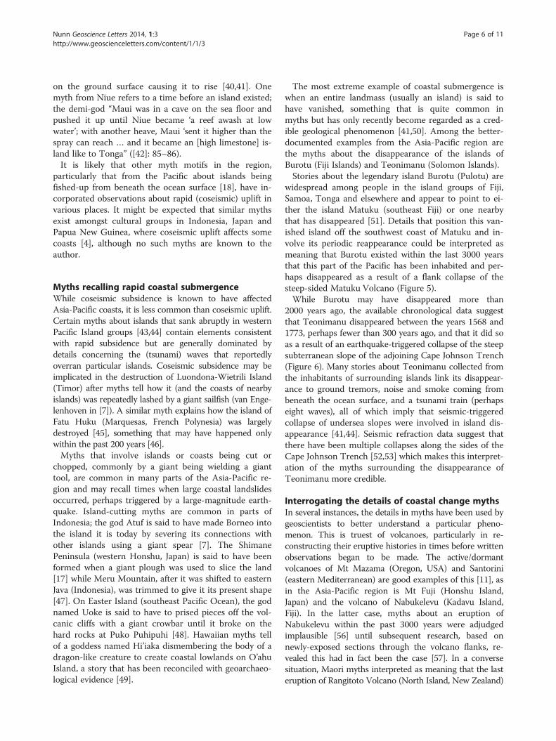
widespread among people in the island groups of Fiji,Samoa, Tonga and elsewhere and appear to point to ei-ther the island Matuku (southeast Fiji) or one nearbythat has disappeared [51]. Details that position this van-ished island off the southwest coast of Matuku and in-volve its periodic reappearance could be interpreted asmeaning that Burotu existed within the last 3000 yearsthat this part of the Pacific has been inhabited and per-haps disappeared as a result of a flank collapse of thesteep-sided Matuku Volcano (Figure 5).While Burotu may have disappeared more than
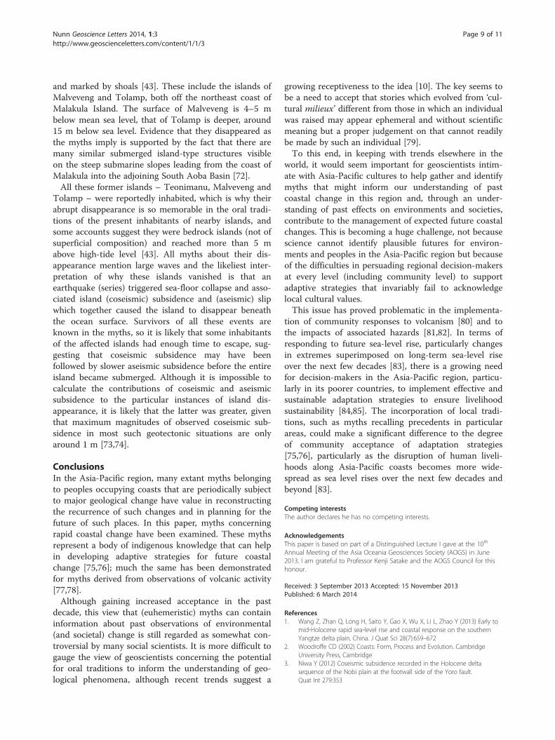
2000 years ago, the available chronological data suggestthat Teonimanu disappeared between the years 1568 and1773, perhaps fewer than 300 years ago, and that it did soas a result of an earthquake-triggered collapse of the steepsubterranean slope of the adjoining Cape Johnson Trench(Figure 6). Many stories about Teonimanu collected fromthe inhabitants of surrounding islands link its disappear-ance to ground tremors, noise and smoke coming frombeneath the ocean surface, and a tsunami train (perhapseight waves), all of which imply that seismic-triggeredcollapse of undersea slopes were involved in island dis-appearance [41,44]. Seismic refraction data suggest thatthere have been multiple collapses along the sides of theCape Johnson Trench [52,53] which makes this interpret-ation of the myths surrounding the disappearance ofTeonimanu more credible.
Interrogating the details of coastal change mythsIn several instances, the details in myths have been used bygeoscientists to better understand a particular pheno-menon. This is truest of volcanoes, particularly in re-constructing their eruptive histories in times before writtenobservations began to be made. The active/dormantvolcanoes of Mt Mazama (Oregon, USA) and Santorini(eastern Mediterranean) are good examples of this [11], asin the Asia-Pacific region is Mt Fuji (Honshu Island,Japan) and the volcano of Nabukelevu (Kadavu Island,Fiji). In the latter case, myths about an eruption ofNabukelevu within the past 3000 years were adjudgedimplausible [56] until subsequent research, based onnewly-exposed sections through the volcano flanks, re-vealed this had in fact been the case [57]. In a conversesituation, Maori myths interpreted as meaning that the lasteruption of Rangitoto Volcano (North Island, New Zealand)

Figure 5 Bathymetry around the island of Matuku (southeast Fiji) showing a submarine platform at −1800-1900 m that might haveformerly been emergent, the source of myths about the island of Burotu in this part of the Pacific (after [41]).
Figure 6 Modern islands and former islands, identified andlocated through myths collected locally [44,54,55], in thecentral eastern Solomon Islands (after [41]).
Nunn Geoscience Letters 2014, 1:3 Page 7 of 11http://www.geoscienceletters.com/content/1/1/3
occurred about AD 1400 have been borne out by scientificdata despite popular suggestions of more recent activity[58].In this section, two aspects of comparatively common
coastal-change myths from the Asia-Pacific region areinterrogated and their likely implications for the under-standing of particular phenomena are deduced. The firstrefers to how myths that recall apparent abrupt coastalflooding leading to permanent coastal change are in factlikely to be expressions of the superimposition of ex-treme wave events on a rising sea level, while the secondfocuses on why many myths about island disappearancefail to mention rapid subsidence even though this is im-plied by the position of these underwater islands today.
Myths recalling abrupt coastal floodingToday the most visible and enduring effects of stormsurges and tsunamis on Asia-Pacific coasts are often ontheir inhabitants and infrastructure yet the impacts oncoastal geology and vegetation are also often profound.In terms of superficial geology, while erosion and ag-gradation may both result from large-wave impacts[59,60], it is clear that the coastline can often return toits original condition so that the net (long-term) impactof these events is almost negligible; in systems language,this concept is that of an intransitive coastal system, inwhich boundary conditions do not change, perturbed byan abrupt (wave impact) event [61]. Exceptions to thisoccur when extreme events of this kind are superimposed

Nunn Geoscience Letters 2014, 1:3 Page 8 of 11http://www.geoscienceletters.com/content/1/1/3
on natural coastal systems that are already changing mono-tonically as a result of long-term forcing, typically involvingeither sea-level rise or sea-level fall: an example of a transi-tive system. In such cases, it would be expected the effectof large-wave impact events (storm surge or tsunami)would change through time and that long-term equilib-rium would never be restored. For example, where stormsurges associated with tropical cyclones are imposed on arising sea level, as in the Bay of Bengal over recent decades,their inland reach will in time become greater and impactsconsequently progressively more extensive [62].For people in earlier (often pre-literate) times, the
most noticeable effects of such transitive changes incoastal systems may have been the cumulative effects ofsuccessive extreme (wave) events resulting from long-termchanges in system boundary conditions, an analogous situ-ation to the effects of extremes on rising 21st-century sealevel [63]. This may have entailed, for example, punctuatedretreat or advance of the shoreline under conditions ofrising or falling sea level respectively. Myth-encoded obser-vations of coastal change and associated submergence ofmany parts of the coast of the Indian sub-continent arepreserved in various ancient texts like the Mahabharataand the Ramayana. They commonly report the ‘impact’ ofa ‘giant wave’ that engulfed a coastal city leading to its ‘de-struction’, the death of many of its inhabitants and (impli-citly) its subsequent abandonment; good examples comefrom myths about the coastal cities of Dwaraka, Mahabali-puram and Poompuhar, which are known to have onceexisted [20,64], together with those whose existence maybe allegorical like the city of “Maturai which was floodedby the sea” ([25]: 294) and Tonipuram, the city of the boat[25].It seems unlikely that a single such event would have
produced such lasting effects unless it was superimposedon a period of prolonged sea-level rise, such as occurredaround the coast of India during the early Holocene,perhaps 7300–4900 cal BP [65,66]. In this interpretation,the event would have been a recurring extreme, perhapsa storm surge or a tsunami, but being superimposed ona rising sea level would have had effects unsurpassed inthe memories of the affected people and may conse-quently have led to the abandonment of the city in ques-tion. Since many of these cities already had coastaldefences – plausibly a response to previous shorelineerosion and extreme wave events – these would havequickly fallen into disrepair, hastening the ‘disappear-ance’ of the city and its change from a real to a mythicalplace. Such a scenario seems applicable to Dwaraka, boththe reality and the location of which were uncertain untilinvestigations in the 1980s [67], and to Mahabalipuramabout which myths were abruptly validated following theexposure of part of the ancient city by tsunami waves gen-erated by the 2004 Indian Ocean Earthquake [24].
The coastal-change myths from Australian Aboriginalinformants are most plausibly explained as a consequenceof inundation by rising postglacial sea level of low-lyingareas, either connecting the mainland with an offshore is-land or separated by a coastal barrier from the deep ocean.While extreme events may be implicated in some of themyths, in most cases these can be adequately explained bysea level rising over the edge of a low-lying coastal plainand flooding it with unprecedented rapidity. From theMelbourne area (see Figure 4), there are various mythsthat recall the sea ‘breaking in’ (Hull in [30]), perhaps dur-ing “a hurricane – trees bending to and fro – then theearth sank, and the sea rushed in … till the void places be-came broad and deep, as they are today” (McCrae in [29]:33). It is likely that the details about extreme winds, earthsinking, and ‘filling’ of these coastal shelves being rapidare all embellishments added to the simple yet otherwisetransgenerationally unmemorable observation of theslowly rising ocean spilling onto a coastal shelf.
Myths ignoring subsidenceAs in other regions, abrupt subsidence during (or imme-diately after) earthquakes is something that is commonin parts of the Asia-Pacific region yet which is not al-ways easy to detect in pre-monitoring records [68,69].And while intuitively we might not expect it to be so,abrupt subsidence at coastal locations is also somethingthat is frequently ignored in myths, usually because ob-servers of these events focus on the large waves that ac-company them. This appears true of many such eventsin ancient Greece [70] as well as the memorable 1755Lisbon Earthquake [71]. In some myths from the Asia-Pacific region, there is clear evidence that rapid subsid-ence affected a particular (former) island even thoughthe myths claim that it was only the accompanying (tsu-nami) waves that caused it to disappear.A good example is Teonimanu (see Figure 6), the
modern location of which is claimed by local people tobe marked by Lark Shoal [44,54,55]. Assuming this iscorrect, then given that the surface of Lark Shoal ispresently 9 m below mean sea level, this suggests that, ifthe island it was once stood above mean high-water level(as it must have been as it was inhabited), then it hassubsided at least a net 12 m or so since this time. Insome reports, Teonimanu was a high (bedrock) island,so 12 m represents a minimum figure for subsidence.But more importantly, none of the myths about the dis-appearance of Teonimanu mention subsidence, only theimpact of successive large waves which are claimed inone account to have run across the island until it was“totally submerged” ([41]: 203).Other examples come from the islands of Vanuatu
where a number of traditions speak of islands that havedisappeared yet whose former locations are well known
Nunn Geoscience Letters 2014, 1:3 Page 9 of 11http://www.geoscienceletters.com/content/1/1/3
and marked by shoals [43]. These include the islands ofMalveveng and Tolamp, both off the northeast coast ofMalakula Island. The surface of Malveveng is 4–5 mbelow mean sea level, that of Tolamp is deeper, around15 m below sea level. Evidence that they disappeared asthe myths imply is supported by the fact that there aremany similar submerged island-type structures visibleon the steep submarine slopes leading from the coast ofMalakula into the adjoining South Aoba Basin [72].All these former islands – Teonimanu, Malveveng and
Tolamp – were reportedly inhabited, which is why theirabrupt disappearance is so memorable in the oral tradi-tions of the present inhabitants of nearby islands, andsome accounts suggest they were bedrock islands (not ofsuperficial composition) and reached more than 5 mabove high-tide level [43]. All myths about their dis-appearance mention large waves and the likeliest inter-pretation of why these islands vanished is that anearthquake (series) triggered sea-floor collapse and asso-ciated island (coseismic) subsidence and (aseismic) slipwhich together caused the island to disappear beneaththe ocean surface. Survivors of all these events areknown in the myths, so it is likely that some inhabitantsof the affected islands had enough time to escape, sug-gesting that coseismic subsidence may have beenfollowed by slower aseismic subsidence before the entireisland became submerged. Although it is impossible tocalculate the contributions of coseismic and aseismicsubsidence to the particular instances of island dis-appearance, it is likely that the latter was greater, giventhat maximum magnitudes of observed coseismic sub-sidence in most such geotectonic situations are onlyaround 1 m [73,74].
ConclusionsIn the Asia-Pacific region, many extant myths belongingto peoples occupying coasts that are periodically subjectto major geological change have value in reconstructingthe recurrence of such changes and in planning for thefuture of such places. In this paper, myths concerningrapid coastal change have been examined. These mythsrepresent a body of indigenous knowledge that can helpin developing adaptive strategies for future coastalchange [75,76]; much the same has been demonstratedfor myths derived from observations of volcanic activity[77,78].Although gaining increased acceptance in the past
decade, this view that (euhemeristic) myths can containinformation about past observations of environmental(and societal) change is still regarded as somewhat con-troversial by many social scientists. It is more difficult togauge the view of geoscientists concerning the potentialfor oral traditions to inform the understanding of geo-logical phenomena, although recent trends suggest a
growing receptiveness to the idea [10]. The key seems tobe a need to accept that stories which evolved from ‘cul-tural milieux’ different from those in which an individualwas raised may appear ephemeral and without scientificmeaning but a proper judgement on that cannot readilybe made by such an individual [79].To this end, in keeping with trends elsewhere in the
world, it would seem important for geoscientists intim-ate with Asia-Pacific cultures to help gather and identifymyths that might inform our understanding of pastcoastal change in this region and, through an under-standing of past effects on environments and societies,contribute to the management of expected future coastalchanges. This is becoming a huge challenge, not becausescience cannot identify plausible futures for environ-ments and peoples in the Asia-Pacific region but becauseof the difficulties in persuading regional decision-makersat every level (including community level) to supportadaptive strategies that invariably fail to acknowledgelocal cultural values.This issue has proved problematic in the implementa-
tion of community responses to volcanism [80] and tothe impacts of associated hazards [81,82]. In terms ofresponding to future sea-level rise, particularly changesin extremes superimposed on long-term sea-level riseover the next few decades [83], there is a growing needfor decision-makers in the Asia-Pacific region, particu-larly in its poorer countries, to implement effective andsustainable adaptation strategies to ensure livelihoodsustainability [84,85]. The incorporation of local tradi-tions, such as myths recalling precedents in particularareas, could make a significant difference to the degreeof community acceptance of adaptation strategies[75,76], particularly as the disruption of human liveli-hoods along Asia-Pacific coasts becomes more wide-spread as sea level rises over the next few decades andbeyond [83].
Competing interestsThe author declares he has no competing interests.
AcknowledgementsThis paper is based on part of a Distinguished Lecture I gave at the 10th
Annual Meeting of the Asia Oceania Geosciences Society (AOGS) in June2013. I am grateful to Professor Kenji Satake and the AOGS Council for thishonour.
Received: 3 September 2013 Accepted: 15 November 2013Published: 6 March 2014
References1. Wang Z, Zhan Q, Long H, Saito Y, Gao X, Wu X, Li L, Zhao Y (2013) Early to
mid‐Holocene rapid sea‐level rise and coastal response on the southernYangtze delta plain, China. J Quat Sci 28(7):659–672
2. Woodroffe CD (2002) Coasts: Form, Process and Evolution. CambridgeUniversity Press, Cambridge
3. Niwa Y (2012) Coseismic subsidence recorded in the Holocene deltasequence of the Nobi plain at the footwall side of the Yoro fault.Quat Int 279:353

Nunn Geoscience Letters 2014, 1:3 Page 10 of 11http://www.geoscienceletters.com/content/1/1/3
4. Ota Y, Yamaguchi M (2004) Holocene coastal uplift in the western PacificRim in the context of late quaternary uplift. Quat Int 120(1):105–117
5. Switzer AD, Sloss CR, Horton BP, Zong Y (2012) Preparing for coastalchange. Quat Sci Rev 54:1–3
6. Knappert J (1992) Pacific Mythology. Aquarian Press, London7. Oppenheimer S (1998) Eden in the east: the drowned continent of
Southeast Asia. Weidenfeld and Nicolson, London8. Ramaswamy S (2000) History at land’s end: lemuria in tamil spatial fables.
J Asian Stud 59(03):575–6029. Storm R (2003) Mythology of Asia and the Far East: Myths and Legends of
China. Southwater, Japan, Thailand, Malaysia and Indonesia, London10. Piccardi L, Masse WB (2007) Myth and Geology. Geological Society of
London, London11. Vitaliano D (1973) Legends of the Earth: their Geologic Origins. Indiana
University Press, Bloomington, Indiana12. Berndt CH, Berndt RM (1994) The Speaking Land: Myth and Story in
Aboriginal Australia. Inner Traditions/Bear & Co, Rochester, Vermont13. Masse WB, Barber EW, Piccardi L, Barber PT (2007) Exploring the Nature of
Myth and its Role in Science. In: Piccardi L, Masse WB (eds) Myth andGeology. Geological Society of London, London
14. Wu L, Wang B, Geng S (2005) Growing typhoon influence on east Asia.Geophys Res Lett 32(18), L18703
15. Terry JP (2007) Tropical Cyclones: Climatology and Impacts in the SouthPacific. Springer, Berlin
16. Palmer E (2007) Out of Sunda? Provenance of the Jōmon Japanese.Nichibunken Japan Rev 19:47–75
17. Carlqvist A (2010) The land-pulling myth and some aspects of historicreality. Japanese J Relig Stud 37(2):185–222
18. Nunn PD (2003) Fished up or thrown down: the geography of Pacific Islandorigin myths. Ann Assoc Am Geogr 93(2):350–364
19. Gaur A (2007) Evidence of shoreline shift on the Northern Saurashtra coast:study based on the submerged temple complex at Pindara. Curr Sci 92(6):733–735
20. Gaur A, Vora K (1999) Ancient shorelines of Gujarat, India, during the Induscivilization (late mid-holocene): a study based on archaeological evidences.Curr Sci 77:180–185
21. Iyengar R, Radhakrishna B (2005) Evolution of the Western coastline of Indiaand the probable location of Dwaraka of Krsna: geological perspectives.J Geol Soc India 66(3):285–292
22. Tripati S, Gaur A, Gudigar P (1996) Marine archaeological explorations in theKaveripoompattinam regions: fresh light on the structural remains. ManEnviron 21(1):86–90
23. Gaur A (1997) Underwater exploration off poompuhar and possible causesof its submergence. Puratattva 26:84–90
24. Rajani M, Kasturirangan K (2013) Sea-level changes and its impact on coastalarchaeological monuments: seven Pagodas of Mahabalipuram, a case study.J Indian Soc Remote Sensing 41(2):461–468
25. Shulman D (1988) The Tamil flood myths and the Cankam Legend. In:Dundas A (ed) The Flood Myth. University of California Press, Berkeley
26. Ramaswamy S (2004) The Lost Land of Lemuria: Fabulous Geographies.University of California Press, Catastrophic Histories, Berkeley
27. Chandrasekharam D (2007) Geo-Mythology of India. In: Piccardi L, Masse WB(eds) Myth and Geology. Geological Society of London, London
28. Bahuguna A, Nayak S, Deshmukh B (2003) IRS views the adamsbridge (bridging India and Sri Lanka). J Indian Soc Remote Sensing31(4):237–239
29. Blake BJ (1991) Woiwurrung, the Melbourne Language. In: Dixon RMW,Blake BJ (eds) The Handbook of Australian Languages. Oxford UniversityPress, Oxford
30. Campbell AH (1967) Aboriginal traditions and the prehistory of Australia.Mankind 6(10):476–481
31. Dixon RM (1980) The Languages of Australia. Cambridge University Press,Cambridge
32. Mulvaney DJ, Kamminga J (1999) Prehistory of Australia. Allen and Unwin,Crows Nest, Australia
33. Moore GF (1884) Diary of Ten Years Eventful Life of an Early Settler inWestern Australia; and also A Descriptive Vocabulary of the Language of theAborigines. Walbrook (facsimile edition 1978 by University of WesternAustralia Press), London
34. Dixon RM (1972) The Dyirbal Language of North Queensland. CambridgeUniversity Press, Cambridge
35. Carson MT, Hung HC, Summerhayes G, Bellwood P (2013) The pottery trailfrom Southeast Asia to the Pacific. J Island Coastal Archaeol 8:17–36
36. Lal KK, Nunn PD (2011) Holocene sea levels and coastal change, south-westViti Levu Island, Fiji. Aust Geogr 42(1):41–51
37. Beckwith MW (1977) Hawaiian Mythology. University of Hawai'i Press,Honolulu
38. Albert S, Udy J, Baines G, McDougall D (2007) Dramatic tectonic uplift offringing reefs on ranongga is Solomon Islands. Coral Reefs 26(4):983–983
39. Nunn PD (1995) Holocene tectonic histories for five islands in thesouth-central lau group, south Pacific. The Holocene 5(2):160–171
40. Nunn PD (2004) Myths and the formation of Niue island, central SouthPacific. J Pac Hist 39(1):99–108
41. Nunn PD (2009) Vanished Islands and hidden continents of the Pacific.University of Hawai’i Press, Honolulu
42. Thomson B (1902) Savage Island: an account of a sojourn in Niue andTonga. John Murray, London
43. Nunn PD, Baniala M, Harrison M, Geraghty P (2006) Vanished islands inVanuatu: new research and a preliminary geohazard assessment.J R Soc N Z 36(1):37–50
44. Nunn PD, Heorake T, Tegu E, Oloni B, Simeon K, Wini L, Usuramo S,Geraghty P (2006) Geohazards revealed by myths in the Pacific: a study ofislands that have disappeared in Solomon Islands. South Pacific Stud27:37–49
45. St Johnston TR (1921) The Islanders of the Pacific, or The Children of theSun. Fisher Unwin, London
46. Filmer P, McNutt M, Webb H, Dixon D (1994) Volcanism and archipelagicaprons in the Marquesas and Hawaiian Islands. Mar Geophys Res16(5):385–406
47. Kaehlig C-B, Wight A, Smith C (2013) Volcanoes of Indonesia: Creators andDestroyers. Editions Didier Millet, Singapore
48. Englert S (1972) Island at the Centre of the World: New Light on EasterIsland. Robert Hale, London
49. Carson MT, Athens JS (2007) Integration of coastal geomorphology,mythology, and archaeological evidence at Kualoa beach, windward O’ahu,Hawaiian Islands. J Island Coastal Archaeol 2(1):24–43
50. Nunn PD, Pastorizo MR (2007) Geological histories and geohazard potentialof Pacific Islands illuminated by myths. In: Piccardi L, Masse WB (eds) Mythand Geology. Geological Society of London, London
51. Geraghty P (1993) Pulotu, Polynesian homeland. J Polyn Soc 102(4):343–38452. Phinney EJ, Mann P, Coffin MF, Shipley TH (1999) Sequence stratigraphy,
structure, and tectonic history of the southwestern Ontong Java plateauadjacent to the North Solomon Trench and Solomon Islands arc. J GeophysRes Solid Earth (1978–2012) 104(B9):20449–20466
53. Phinney EJ, Mann P, Coffin MF, Shipley TH (2004) Sequence stratigraphy,structural style, and age of deformation of the Malaita accretionary prism(Solomon arc–Ontong Java Plateau convergent zone). Tectonophysics 389(3):221–246
54. Fox CE (1925) The Threshold of the Pacific. Knopf, New York55. Woodford CM (1926) Notes on the Solomon Islands. Geogr J 68(6):481–48756. Nunn PD (1999) Early human settlement and the possibility of
contemporaneous volcanism, western Kadavu, Fiji. Domodomo (Schol J FijiMuseum) 12:36–49
57. Cronin SJ, Ferland MA, Terry JP (2004) Nabukelevu volcano (Mt. Washington),Kadavu – a source of hitherto unknown volcanic hazard in Fiji. J VolcanolGeotherm Res 131(3):371–396
58. Nichol R (1992) The eruption history of Rangitoto: reappraisal of a smallNew Zealand myth. J R Soc N Z 22(3):159–180
59. Etienne S, Terry JP (2012) Coral boulders, gravel tongues and sand sheets:features of coastal accretion and sediment nourishment by Cyclone Tomas(march 2010) on Taveuni Island, Fiji. Geomorphology 175:54–65
60. Tanaka H, Tinh NX, Umeda M, Hirao R, Pradjoko E, Mano A, Udo K (2012)Coastal and estuarine morphology changes induced by the 2011 Great EastJapan Earthquake Tsunami. Coast Eng J 54(01):1250010
61. Brunsden D, Thornes JB (1979) Landscape sensitivity and change. Trans InstBr Geogr 4:463–484
62. Karim MF, Mimura N (2008) Impacts of climate change and sea-level rise oncyclonic storm surge floods in Bangladesh. Glob Environ Chang 18(3):490–500
63. Field CB, Barros V, Stocker TF, Dahe Q (2012) Managing the Risks of ExtremeEvents and Disasters to Advance Climate Change Adaptation: Special Reportof the Intergovernmental Panel on Climate Change. Cambridge UniversityPress, Cambridge

Nunn Geoscience Letters 2014, 1:3 Page 11 of 11http://www.geoscienceletters.com/content/1/1/3
64. Tripati S (2009) Coastal structural remains on the east coast of India:evidence of maritime activities and their significances. In: Reddy PC (ed)Saundaryashri: Studies of Indian History, Archaeology, Literature andPhilosophy (Festschrift to Professor A. Sundara). Sharada Publishing House,New Delhi
65. Kench PS, Smithers SG, McLean RF, Nichol SL (2009) Holocene reef growthin the Maldives: evidence of a mid-holocene sea-level highstand in thecentral Indian Ocean. Geology 37(5):455–458
66. Ranasinghe PN, Ortiz JD, Moore AL, McAdoo B, Wells N, Siriwardana CHER,Wijesundara DTDS (2013) Mid–Late Holocene coastal environmentalchanges in southeastern Sri Lanka: New evidence for sea level variations insouthern Bay of Bengal. Quat Int 298:20–36
67. Rao S (1990) Excavation of the legendary city of Dvaraka in the Arabian Sea.Marine Archaeol 1:59–98
68. Dura T, Rubin CM, Kelsey HM, Horton BP, Hawkes A, Vane CH, Daryono M,Pre CG, Ladinsky T, Bradley S (2011) Stratigraphic record of holocenecoseismic subsidence, Padang, West Sumatra. J Geophys Res Solid EarthB11306
69. Niwa Y, Sugai T, Yasue KI (2012) Activity of the Yoro fault systemdetermined from coseismic subsidence events recorded in the Holocenedelta sequence of the Nobi plain, central Japan. Bull Seismol Soc Am 102(3):1120–1134
70. Soter S, Katsonopoulou D (2011) Submergence and uplift of settlements inthe area of Helike, Greece, from the Early Bronze Age to late antiquity.Geoarchaeology 26(4):584–610
71. Oliveira C (2008) Review of the 1755 Lisbon earthquake based on recentanalyses of historical observations. Historical Seismol 2:261–300
72. Greene HG, Wong FL (1988) Geology and Offshore Resources of PacificIsland Arcs - Vanuatu Region. Circum-Pacific Council for Energy and MineralResources, Houston
73. Leonard LJ, Hyndman RD, Mazzotti S (2004) Coseismic subsidence in the1700 great cascadia earthquake: coastal estimates versus elastic dislocationmodels. Geol Soc Am Bull 116(5–6):655–670
74. Rajendran C, Rajendran K, Anu R, Earnest A, Machado T, Mohan P,Freymueller J (2007) Crustal deformation and seismic history associatedwith the 2004 Indian Ocean earthquake: a perspective from theAndaman–Nicobar Islands. Bull Seismol Soc Am 97(1A):S174–S191
75. Mercer J, Dominey-Howes D, Kelman I, Lloyd K (2007) The potential forcombining indigenous and western knowledge in reducing vulnerability toenvironmental hazards in small island developing states. Environ Hazards 7(4):245–256
76. Mercer J, Kelman I, Taranis L, Suchet-Pearson S (2010) Framework forintegrating indigenous and scientific knowledge for disaster risk reduction.Disasters 34(1):214–239
77. Cashman KV, Cronin SJ (2008) Welcoming a monster to the world: myths,oral tradition, and modern societal response to volcanic disasters. J VolcanolGeotherm Res 176(3):407–418
78. Cronin SJ, Cashman KV (2008) Volcanic Oral Traditions in Hazard Assessmentand Mitigation. In: Gratton J, Torrence R (eds) Living Under the Shadow:Cultural Impacts of Volcanic Eruption. Left Coast Press, Oakland, California
79. Heyd T, Brooks N (2009) Exploring Cultural Dimensions of Adaptation toClimate Change. In: Adger WN, Lorenzoni I, O’Brien K (eds) Adapting toClimate Change: Thresholds, Values, Governance. Cambridge UniversityPress, Cambridge
80. De Bélizal É, Lavigne F, Gaillard JC, Grancher D, Pratomo I, Komorowski J–C(2012) The 2007 eruption of Kelut volcano (East Java, Indonesia):phenomenology, crisis management and social response. Geomorphology136(1):165–175
81. Bankoff G (2003) Cultures of Disaster: Society and Natural Hazard in thePhilippines. Routledge, London
82. Rodolfo KS, Umbal JV (2008) A prehistoric lahar-dammed lake and eruptionof Mount Pinatubo described in a Philippine aborigine legend. J VolcanolGeotherm Res 176(3):432–437
83. Church JA, Clark PU, Cazenave A, Gregory JM, Jevrejeva S, Levermann A,Merrifield MA, Milne GA, Nerem RS, Nunn PD, Payne AJ, Pfeffer WT,Stammer D, Unnikrishnan AS Sea Level Change. In: Stocker TF, Qin D,Plattner G-K, Tignor M, Allen SK, Boschung J, Nauels A, Xia Y, Bex V, MidgleyPM (eds) Climate Change 2013: The Physical Science Basis. Contribution ofWorking Group I to the Fifth Assessment Report of the IntergovernmentalPanel on Climate Change (IPCC). Cambridge University Press, Cambridge, inpress
84. Lasco R, Kameyama Y, Jiang K, Peñalba L, Pulhin J, Shukla P, SubramanianSM (2014) Climate and Sustainability. In: Manton MJ, Stevenson LA (eds)Climate in Asia and the Pacific. Springer, Dordrecht
85. Nunn PD (2013) The end of the Pacific? Effects of sea level rise on PacificIsland livelihoods. Singap J Trop Geogr 34(2):143–171
doi:10.1186/2196-4092-1-3Cite this article as: Nunn: Geohazards and myths: ancient memories ofrapid coastal change in the Asia-Pacific region and their value to futureadaptation. Geoscience Letters 2014 1:3.
Submit your manuscript to a journal and benefi t from:
7 Convenient online submission
7 Rigorous peer review
7 Immediate publication on acceptance
7 Open access: articles freely available online
7 High visibility within the fi eld
7 Retaining the copyright to your article
Submit your next manuscript at 7 springeropen.com