
GEOGRAPHY: PAPER II EXAMINATION NUMBER · Bela-Bela was originally known as Warmbaths or Warmbad....
16
NATIONAL SENIOR CERTIFICATE EXAMINATION NOVEMBER 2015 GEOGRAPHY: PAPER II EXAMINATION NUMBER Time: 1½ hours 100 marks PLEASE READ THE FOLLOWING INSTRUCTIONS CAREFULLY 1. Write your examination number in the appropriate blocks provided above. 2. This question paper consists of 16 pages, a topographic map and a Colour Insert of one page (i). Please check that your paper is complete. 3. Read the questions carefully. 4. Answer ALL the questions in the spaces provided on the question paper. 5. Carefully study the 1:50 000 topographic map extract 2428CD BELA-BELA and the accompanying aerial photograph sheet (Photograph 2 of the Colour Insert) before answering the questions. 6. The topographic map has grid lines with markings A to G and 1 to 11 that may be used to identify locations according to blocks. 7. The topographic map extract, aerial photograph and your completed question paper must be handed to the invigilator at the end of the examination. The maps and photos may be retained by the school for future use. 8. On page 2 there is a glossary of words. This will help you understand what the words in bold in the questions are asking you to do. There is also an English-Afrikaans translation of some words appearing on the map. 9. A magnifying glass and calculator may be used. 10. It is in your own interest to write legibly and to present your work neatly. 11. You may use the back page for rough work. No marks will be allocated to rough work. FOR MARKER'S USE ONLY Question 1 2 3 4 Total Marks 25 24 35 16 100 Obtained IEB Copyright © 2015 PLEASE TURN OVER
Transcript of GEOGRAPHY: PAPER II EXAMINATION NUMBER · Bela-Bela was originally known as Warmbaths or Warmbad....

NATIONAL SENIOR CERTIFICATE EXAMINATION NOVEMBER 2015
GEOGRAPHY: PAPER II
EXAMINATION NUMBER
Time: 1½ hours 100 marks PLEASE READ THE FOLLOWING INSTRUCTIONS CAREFULLY 1. Write your examination number in the appropriate blocks provided above. 2. This question paper consists of 16 pages, a topographic map and a Colour Insert of
one page (i). Please check that your paper is complete. 3. Read the questions carefully. 4. Answer ALL the questions in the spaces provided on the question paper. 5. Carefully study the 1:50 000 topographic map extract 2428CD BELA-BELA and the
accompanying aerial photograph sheet (Photograph 2 of the Colour Insert) before answering the questions.
6. The topographic map has grid lines with markings A to G and 1 to 11 that may be used to
identify locations according to blocks. 7. The topographic map extract, aerial photograph and your completed question paper must be
handed to the invigilator at the end of the examination. The maps and photos may be retained by the school for future use.
8. On page 2 there is a glossary of words. This will help you understand what the words in
bold in the questions are asking you to do. There is also an English-Afrikaans translation of some words appearing on the map.
9. A magnifying glass and calculator may be used. 10. It is in your own interest to write legibly and to present your work neatly. 11. You may use the back page for rough work. No marks will be allocated to rough work.
FOR MARKER'S USE ONLY
Question 1 2 3 4 Total
Marks 25 24 35 16 100
Obtained
IEB Copyright © 2015 PLEASE TURN OVER
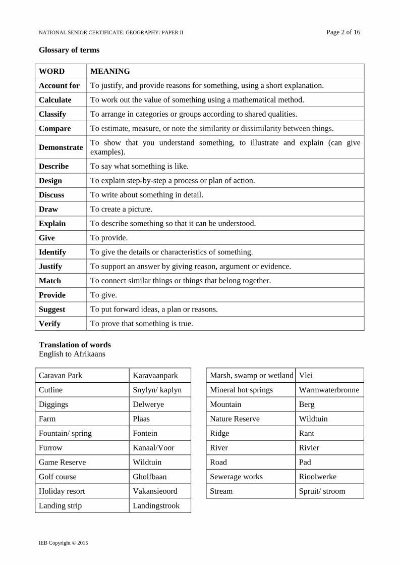
NATIONAL SENIOR CERTIFICATE: GEOGRAPHY: PAPER II Page 2 of 16 Glossary of terms
WORD MEANING
Account for To justify, and provide reasons for something, using a short explanation.
Calculate To work out the value of something using a mathematical method.
Classify To arrange in categories or groups according to shared qualities.
Compare To estimate, measure, or note the similarity or dissimilarity between things.
Demonstrate To show that you understand something, to illustrate and explain (can give examples).
Describe To say what something is like.
Design To explain step-by-step a process or plan of action.
Discuss To write about something in detail.
Draw To create a picture.
Explain To describe something so that it can be understood.
Give To provide.
Identify To give the details or characteristics of something.
Justify To support an answer by giving reason, argument or evidence.
Match To connect similar things or things that belong together.
Provide To give.
Suggest To put forward ideas, a plan or reasons.
Verify To prove that something is true. Translation of words English to Afrikaans Caravan Park Karavaanpark
Cutline Snylyn/ kaplyn
Diggings Delwerye
Farm Plaas
Fountain/ spring Fontein
Furrow Kanaal/Voor
Game Reserve Wildtuin
Golf course Gholfbaan
Holiday resort Vakansieoord
Landing strip Landingstrook
Marsh, swamp or wetland Vlei
Mineral hot springs Warmwaterbronne
Mountain Berg
Nature Reserve Wildtuin
Ridge Rant
River Rivier
Road Pad
Sewerage works Rioolwerke
Stream Spruit/ stroom
IEB Copyright © 2015

NATIONAL SENIOR CERTIFICATE: GEOGRAPHY: PAPER II Page 3 of 16 Location map: Location of Bela-Bela in South Africa
Bela-Bela
B
A
The town is situated in the Waterberg district of Limpopo Province and lies about 10 km from the N1 road between Pretoria and Polokwane. Bela-Bela meaning 'the pot that boils', derives its name from the geothermic hot springs around which the town was built. Bela-Bela was originally known as Warmbaths or Warmbad. Bela-Bela is a popular health and holiday destination attracting both local and foreign tourists. The town lies on the Springbok Flats, a fertile basin, dominated by agricultural activities, conservation and wildlife farming.
[Adapted from: <www.warmbath.co.za> and <www.umbono.com>] QUESTION 1 ATLAS USE, MAP ORIENTATION AND TECHNIQUES 1.1 Refer to the location map above, as well as the topographic map extract 2428CD
BELA-BELA, to answer the following questions. Tick the correct box.
1.1.1 The neighbouring country labelled A on the location map above is …
Botswana
Lesotho
Namibia
Zimbabwe (1)
1.1.2 The province labelled B on the location map above is …
Free State
Gauteng
Mpumalanga
North West (1) 1.1.3 The map reference number for the map sheet to the north east of 2428CD
BELA-BELA is …
2428CA
2428DA
2428DC
2429DA (1) IEB Copyright © 2015 PLEASE TURN OVER

NATIONAL SENIOR CERTIFICATE: GEOGRAPHY: PAPER II Page 4 of 16
N1
R516
R101
Bela-Bela
Springbok Flats and proposed coal mining (fracking) area
Plat River
Moretele R
R516
Y
1.1.4 The road distance (km) to Mabula travelling along the R516 from point X (E3) is …
5 km 10 km 29 km 34 km
(2)
1.1.5 The approximate true bearing of trigonometrical beacon 65 (C2) from trigonometrical beacon 7 at Buyskop (C6) is …
84º 96º 98º 276º
(2)
1.1.6 Refer to the topographic map extract 2428CD BELA-BELA and Figure 1 below.
Figure 1: Main communication links and drainage features, Bela-Bela, Limpopo
IEB Copyright © 2015

NATIONAL SENIOR CERTIFICATE: GEOGRAPHY: PAPER II Page 5 of 16
(a) In which general direction is the Moretele River draining at point Y on Figure 1?
_______________________________________________________ (2)
(b) Refer to the topographic map extract. Verify the statement that the
Mineral Hot Springs in Bela-Bela (E3) are approximately 10 km from the N1.
_______________________________________________________ _______________________________________________________ (2)
(c) The N1, R101 and R516 roads, as well as the railway links, generally
follow straight routes. Provide map evidence to suggest what this tells us about the relief of the area.
_______________________________________________________ _______________________________________________________ (2)
1.2 Geographic techniques
Refer to the topographic map extract 2428CD BELA-BELA to answer the questions. Tick the correct box.
1.2.1 The latitude reference of the ground sign G in F4 is …
28º 18' 40" E 28º 18' 40" S 24º 54' 40" S 24º 54' 40" E
(2)
1.2.2 The mean magnetic declination for the topographic map extract 2428CD BELA-BELA in 2015 will be …
16º 35' W of True North 16º 47' W of True North 16º 23' W of True North 16º 23' E of True North
(2) 1.2.3 (a) There are several cutlines indicated on the mapped area (e.g. B2 and
E6). Draw the correct map symbol for a cutline in the block below.
(1) IEB Copyright © 2015 PLEASE TURN OVER

NATIONAL SENIOR CERTIFICATE: GEOGRAPHY: PAPER II Page 6 of 16
(b) Explain what a cutline is.
_______________________________________________________ _______________________________________________________ (2)
1.2.4 (a) The Waterberg range is sloping to the north (B3). Match this
statement to the sketch cross section that represents the correct profile of the Waterberg on Bospoort farm (B3). Tick the correct option.
(2)
(b) (i) Is trigonometrical station 65 (C2) intervisible from spot height 1396 (B1)?
Tick the correct answer.
YES
NO
(1)
(ii) Justify your answer to (i) above.
Justification: ______________________________________
_________________________________________________ (2) [25]
Q1 subtotal
IEB Copyright © 2015

NATIONAL SENIOR CERTIFICATE: GEOGRAPHY: PAPER II Page 7 of 16 QUESTION 2 CLIMATE AND DRAINAGE OF THE AREA
2.1 Study Figure 2, a climate graph for Bela-Bela.
[Source: <www.en.climate-data.org>]
Figure 2: Climate graph: Bela-Bela 2.1.1 Calculate the approximate total annual rainfall (mm) for Bela-Bela.
__________________________________ mm (2) 2.1.2 Given the above rainfall data (Question 2.1.1), suggest why there are many
non-perennial rivers surrounding the Bela-Bela area.
_____________________________________________________________ _____________________________________________________________ (2)
2.1.3 Calculate the range (ºC) in the average annual temperature.
_________________________________________________________ ºC (2)
0
5
10
15
20
25
0
20
40
60
80
100
120
140
Aver
age
Tem
pera
ture
(ºC)
Rain
fall
(mm
)
Months
IEB Copyright © 2015 PLEASE TURN OVER
NATIONAL SENIOR CERTIFICATE: GEOGRAPHY: PAPER II Page 8 of 16 2.2 Drainage of the area
Refer to the topographic map extract 2428CD BELA-BELA.
2.2.1 Identify the dominant drainage pattern in B3-4.
_____________________________________________________________ (2)
2.2.2 Refer to B3 and C3. Provide evidence that suggests that water is critical to
farming in the area.
• __________________________________________________________
__________________________________________________________
• __________________________________________________________
__________________________________________________________ (4)
IEB Copyright © 2015
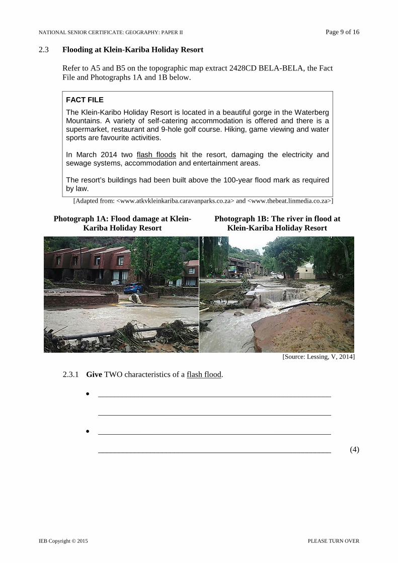
NATIONAL SENIOR CERTIFICATE: GEOGRAPHY: PAPER II Page 9 of 16 2.3 Flooding at Klein-Kariba Holiday Resort
Refer to A5 and B5 on the topographic map extract 2428CD BELA-BELA, the Fact File and Photographs 1A and 1B below.
FACT FILE The Klein-Karibo Holiday Resort is located in a beautiful gorge in the Waterberg Mountains. A variety of self-catering accommodation is offered and there is a supermarket, restaurant and 9-hole golf course. Hiking, game viewing and water sports are favourite activities. In March 2014 two flash floods hit the resort, damaging the electricity and sewage systems, accommodation and entertainment areas. The resort’s buildings had been built above the 100-year flood mark as required by law.
[Adapted from: <www.atkvkleinkariba.caravanparks.co.za> and <www.thebeat.linmedia.co.za>]
Photograph 1A: Flood damage at Klein- Kariba Holiday Resort
Photograph 1B: The river in flood at Klein-Kariba Holiday Resort
[Source: Lessing, V, 2014]
2.3.1 Give TWO characteristics of a flash flood.
• __________________________________________________________
__________________________________________________________
• __________________________________________________________
__________________________________________________________ (4)
IEB Copyright © 2015 PLEASE TURN OVER
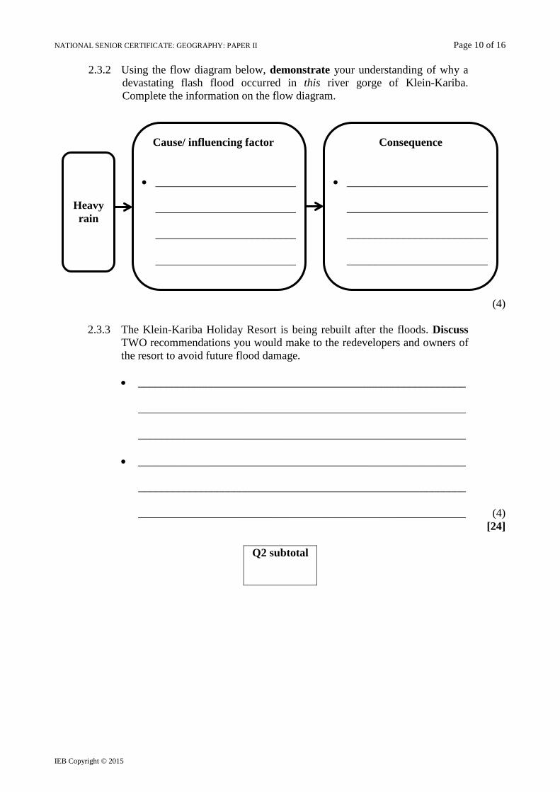
NATIONAL SENIOR CERTIFICATE: GEOGRAPHY: PAPER II Page 10 of 16
2.3.2 Using the flow diagram below, demonstrate your understanding of why a devastating flash flood occurred in this river gorge of Klein-Kariba. Complete the information on the flow diagram.
(4)
2.3.3 The Klein-Kariba Holiday Resort is being rebuilt after the floods. Discuss TWO recommendations you would make to the redevelopers and owners of the resort to avoid future flood damage.
• __________________________________________________________
__________________________________________________________
__________________________________________________________
• __________________________________________________________
__________________________________________________________ __________________________________________________________ (4)
[24]
Q2 subtotal
Heavy rain
Cause/ influencing factor
• _________________________
_________________________ _________________________ _________________________
Consequence
• _________________________
_________________________ _________________________ _________________________
IEB Copyright © 2015

NATIONAL SENIOR CERTIFICATE: GEOGRAPHY: PAPER II Page 11 of 16 QUESTION 3 PHOTOGRAPH ANALYSIS, GIS CONCEPTS, RURAL AND
URBAN LAND-USE Refer to Photograph 2 below as well as the topographic map extract 2428CD BELA-BELA to answer the following questions. A colour image is provided in the Colour Insert. The area shown on Photograph 2 is marked by a black block on the topographic map extract 2428CD BELA-BELA. Photograph 2: Land-use to the south of Bela-Bela
3.1 FOUR features (A – D) have been labelled on Photograph 2.
Identify these features.
A _________________________________________ B _________________________________________ C _________________________________________
D _________________________________________ (8)
A
B C
D
IEB Copyright © 2015 PLEASE TURN OVER
NATIONAL SENIOR CERTIFICATE: GEOGRAPHY: PAPER II Page 12 of 16 3.2 Refer to the topographic map extract 2428CD BELA-BELA.
3.2.1 The street pattern of Bela-Bela (Y in D3) is predominantly … (Tick the correct option)
Grid Haphazard Modern planned Radial
(2)
3.2.2 The farming activity at Welgelee (F6-7) is … (Tick the correct option)
Extensive Intensive Plantations Orchards/ vineyards
(2)
3.2.3 Provide ONE reason why Bela-Bela is classified as a central place town.
_____________________________________________________________ _____________________________________________________________ (2)
3.3 Refer to the topographic map extract 2428CD BELA-BELA as well as
Photograph 2 on page 11/ page (i) of the Colour Insert. There are numerous agricultural small holdings to the west of the Aventura Warmbad Game Reserve (E1-2, F1-2, G1-2).
3.3.1 In which land-use zone are these small holdings found?
_____________________________________________________________ (1) 3.3.2 Account for the location of these small holdings.
• __________________________________________________________
__________________________________________________________
• __________________________________________________________
__________________________________________________________ (4)
IEB Copyright © 2015
NATIONAL SENIOR CERTIFICATE: GEOGRAPHY: PAPER II Page 13 of 16 3.4 3.4.1 Study the Aventura Warmbad Game Reserve (E2-3, F2-3, G2-3) and
Sondela Nature Reserve (C8-11, D8-11, E8-11, F9-11, G9-10).
Complete Table 1 below to compare various features of the two reserves.
Table 1: Comparing Aventura Warmbad Game Reserve and Sondela Nature Reserve
Features Aventura Warmbad Game
Reserve Sondela Nature Reserve
Amenities and/ or facilities
__________________________ __________________________
__________________________ __________________________
Recreational activities
__________________________ __________________________
__________________________ __________________________
Access to the freeway (N1)
__________________________ __________________________
__________________________ __________________________
(12)
3.4.2 Circle the correct underlined answer in the statements below.
(a) The information you have entered in Table 1 above is referred to as raster/ attribute/ spatial data. (2)
(b) The area within the boundary of Sondela Nature Reserve forms
a point/ line/ polygon data set. (2) [35]
Q3 subtotal
IEB Copyright © 2015 PLEASE TURN OVER

NATIONAL SENIOR CERTIFICATE: GEOGRAPHY: PAPER II Page 14 of 16 QUESTION 4 ECONOMIC ACTIVITIES Study the Fact File below.
FACT FILE Umbono Mining is currently conducting an Environmental Impact Assessment of the Springbok Flats, an area shown on Figure 1 (page 4). The coalfield to be fracked is a remnant of the main Karoo basin. The area is dominated by maize, sorghum, cotton, sunflower and cattle farming activities as well as a variety of conservation and wildlife farming activities such as game farms, tourist lodges and hunting operations. There are a number of major holiday resorts in the area such as Bela-Bela Forever and ATKV Klein Kariba, many game farms, a few golf estates and nature reserves such as Sondela. Industry and mining are not significant in the area.
[Source: <www.umbono.com>] 4.1 Classify the type of economic activity that is taking place at:
Towoomba Research Farm (F5, 6). _____________________________________ (2) 4.2 Describe TWO advantages of the proposed coal mining (fracking) for the area.
• ________________________________________________________________
________________________________________________________________
• ________________________________________________________________
________________________________________________________________ (4)
4.3 Various stakeholders have met at several public meetings and are against fracking
occurring in the area. Design a PowerPoint presentation to persuade the mining company not to go ahead with the proposed mining.
Slides should include:
• Impact on game/ nature reserves • Impact on agriculture • Impact on water (surface and ground)
You will be marked on the geographical content and concepts of your slides. You must make specific reference to places that will be affected (block/ grid references). Use relevant points and suitable titles or subtitles on your slides (on page 15).
Marking rubric for presentation
Criteria Maximum marks Relevant geographical points or factors: • Reference to location is important; it may include a map • Factors not favourable to mining in the area – use of specific
subheadings provided • 3 slides
6
Title slide 2 Overall presentation 2 Total 10
IEB Copyright © 2015
NATIONAL SENIOR CERTIFICATE: GEOGRAPHY: PAPER II Page 15 of 16 POWERPOINT PRESENTATION Slide 1 (Title) Slide 2 Impact on game/ nature
reserves Slide 3 Impact on agriculture Slide 4 Impact on water (surface
and ground)
(10) [16]
Q4 subtotal
Total: 100 marks IEB Copyright © 2015 PLEASE TURN OVER

NATIONAL SENIOR CERTIFICATE: GEOGRAPHY: PAPER II Page 16 of 16
Rough work (Not for marks)
IEB Copyright © 2015


![Lermontov Bela.doc · Web viewMikhail Lermontov [Bela] Bela Bela [I] Ай Я [was] воз был [traveling] traveling путешествие [along] элонг вперед [the]](https://static.fdocuments.us/doc/165x107/6000c96ccd2c3329594c851b/lermontov-beladoc-web-view-mikhail-lermontov-bela-bela-bela-i-was.jpg)