GEOGRAPHY P2 FEBRUARY/MARCH 2012 MEMORANDUM · Title: Microsoft Word - Geography P2 Feb-March 2012...
10
Copyright reserved Please turn over MARKS: 100 This memorandum consists of 10 pages. GEOGRAPHY P2 FEBRUARY/MARCH 2012 MEMORANDUM NATIONAL SENIOR CERTIFICATE GRADE 12
Transcript of GEOGRAPHY P2 FEBRUARY/MARCH 2012 MEMORANDUM · Title: Microsoft Word - Geography P2 Feb-March 2012...

Copyright reserved Please turn over
MARKS: 100
This memorandum consists of 10 pages.
GEOGRAPHY P2
FEBRUARY/MARCH 2012
MEMORANDUM
NATIONAL SENIOR CERTIFICATE
GRADE 12
kerrygsilis
Typewritten Text
Want a tutor to help you ace this exam? www.teachme2.co.za/matric
Geography/P2 DBE/Feb.–Mar. 2012 NSC – Memorandum
Copyright reserved Please turn over
2
RESOURCE MATERIAL 1. 2. 3.
An extract from topographical map 3318DB PAARL. Orthophoto map 3318DB 25 PAARL. NOTE: The resource material must be collected by the schools for their own
use.
INSTRUCTIONS AND INFORMATION 1. 2. 3. 4. 5. 6. 7.
Write your EXAMINATION NUMBER and your CENTRE NUMBER in the spaces provided on the cover page. Answer ALL the questions in the spaces provided in this question paper. You are supplied with a 1 : 50 000 topographical map 3318DB PAARL and an orthophoto map of a part of the mapped area. You must hand the topographical map and the orthophoto map to the invigilator at the end of this examination session. You may use the blank page at the back of this question paper for all rough work and calculations. Do NOT detach this page from the question paper. Show ALL calculations. Marks will be allocated for calculations and formulae. You may use a non-programmable calculator.
Geography/P2 DBE/Feb.–Mar. 2012 NSC – Memorandum
Copyright reserved Please turn over
3
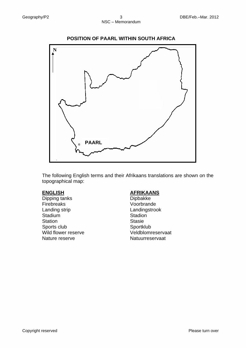
POSITION OF PAARL WITHIN SOUTH AFRICA The following English terms and their Afrikaans translations are shown on the
topographical map:
ENGLISH
Dipping tanks Firebreaks Landing strip Stadium Station Sports club Wild flower reserve Nature reserve
AFRIKAANS Dipbakke Voorbrande Landingstrook Stadion Stasie Sportklub Veldblomreservaat Natuurreservaat
N
PAARL
kerrygsilis
Typewritten Text
Want a tutor to help you ace this exam? www.teachme2.co.za/matric
Geography/P2 DBE/Feb.–Mar. 2012 NSC – Memorandum
Copyright reserved Please turn over
4
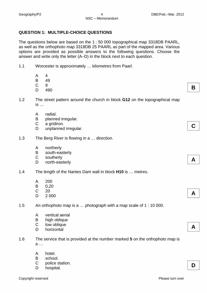
QUESTION 1: MULTIPLE-CHOICE QUESTIONS The questions below are based on the 1 : 50 000 topographical map 3318DB PAARL, as well as the orthophoto map 3318DB 25 PAARL as part of the mapped area. Various options are provided as possible answers to the following questions. Choose the answer and write only the letter (A–D) in the block next to each question.
1.1 Worcester is approximately … kilometres from Paarl. A
B C D
4 49 9 490
B 1.2 The street pattern around the church in block G12 on the topographical map
is …
A
B C D
radial. planned irregular. a gridiron. unplanned irregular.
C 1.3 The Berg River is flowing in a … direction. A
B C D
northerly south-easterly southerly north-easterly
A 1.4 The length of the Nantes Dam wall in block H10 is … metres. A
B C D
200 0,20 20 2 000
A 1.5 An orthophoto map is a … photograph with a map scale of 1 : 10 000. A
B C D
vertical aerial high oblique low oblique horizontal
A 1.6 The service that is provided at the number marked 5 on the orthophoto map is
a …
A
B C D
hotel. school. police station. hospital.
D
Geography/P2 DBE/Feb.–Mar. 2012 NSC – Memorandum
Copyright reserved Please turn over
5
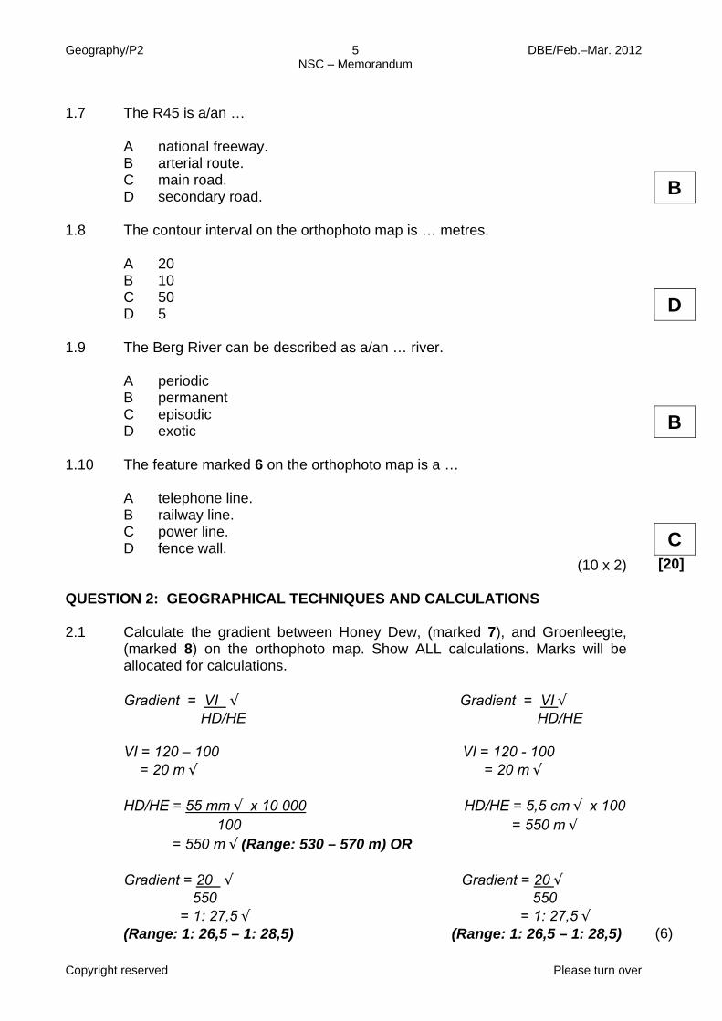
1.7 The R45 is a/an … A
B C D
national freeway. arterial route. main road. secondary road.
B 1.8 The contour interval on the orthophoto map is … metres. A
B C D
20 10 50 5
D 1.9 The Berg River can be described as a/an … river. A
B C D
periodic permanent episodic exotic
B 1.10 The feature marked 6 on the orthophoto map is a …
A B C D
telephone line. railway line. power line. fence wall.
(10 x 2)
C [20]
QUESTION 2: GEOGRAPHICAL TECHNIQUES AND CALCULATIONS 2.1 Calculate the gradient between Honey Dew, (marked 7), and Groenleegte,
(marked 8) on the orthophoto map. Show ALL calculations. Marks will be allocated for calculations. Gradient = VI √ Gradient = VI √ HD/HE HD/HE VI = 120 – 100 VI = 120 - 100 = 20 m √ = 20 m √ HD/HE = 55 mm √ x 10 000 HD/HE = 5,5 cm √ x 100 100 = 550 m √ = 550 m √ (Range: 530 – 570 m) OR Gradient = 20 √ Gradient = 20 √ 550 550 = 1: 27,5 √ = 1: 27,5 √ (Range: 1: 26,5 – 1: 28,5) (Range: 1: 26,5 – 1: 28,5)
(6)
kerrygsilis
Typewritten Text
Want a tutor to help you ace this exam? www.teachme2.co.za/matric
Geography/P2 DBE/Feb.–Mar. 2012 NSC – Memorandum
Copyright reserved Please turn over
6
2.2 Refer to both the topographical map and the orthophoto map when answering
the questions below.
2.2.1
2.2.2 2.2.3
Which one, the topographical map or the orthophoto map, has a larger scale? Orthophoto map √ Give ONE reason to support your answer to QUESTION 2.2.1. Features are less reduced √ Can see more detail √ [Any ONE] By how much is the scale of the map that you have selected in QUESTION 2.2.1 larger? 5 times √
(1) (1) (1)
2.3
2.3.1 2.3.2 2.3.3 2.3.4
Give the true bearing of trigonometrical station 184 (block E6) from trigonometrical station 227 (block D5). 135° √ Calculate the magnetic bearing of trigonometrical station 184 (block E6) from trigonometrical station 227 (block D5). Magnetic bearing = True bearing + magnetic declination = 135° + 23° 33´W √ = 158° 33´W √ (Range: 156° 33´W - 160° 33´W) Is there intervisibility between trigonometrical station 184 (block E6) and trigonometrical station 227 (block D5)? Yes √ Give a reason for your answer to QUESTION 2.3.3. No obstacles between these two points. √
(1) (2) (1) (1)
Geography/P2 DBE/Feb.–Mar. 2012 NSC – Memorandum
Copyright reserved Please turn over
7
2.4 Calculate the area covered by the orthophoto map in km². Use the
demarcated area on the topographical map for all measurements. Show ALL calculations. Marks will be allocated for calculations. Area = length x breadth √ = (9,3 cm x 0,5) km √ x (11 cm x 0,5) km √ = 4,65 km √ x 5,5 km √ = 25,57 km² √ (Range: 24,57 km²–26,6 km²)
(6) [20]
QUESTION 3: APPLICATION OF THEORY/MAP AND PHOTO INTERPRETATION 3.1 Refer to both the topographical map and the orthophoto map when answering
the questions below.
3.1.1
Name ONE primary activity practised in the mapped area. Farming √√ (1 x 2)
(2)
3.1.2 Give TWO reasons that favour the development of the activity
mentioned in QUESTION 3.1.1. Fertile soil √√ Availability of water √√ Flat land √√ [Any TWO] (2 x 2)
(4)
3.1.3
Name an industry that is likely to be found in Paarl considering the availability of local raw materials. Wine industries√√ Fruit canning√√ [Any ONE] (1 x 2)
(2)
3.1.4
Paarl has a large industrial area (F12/13). Name TWO factors that favour the location of these industries. Close to transport routes √√ Close to raw materials √√ Availability of labour √√ Close to market √√ Close to water √√ [Any TWO] (2 x 2)
(4)
kerrygsilis
Typewritten Text
Want a tutor to help you ace this exam? www.teachme2.co.za/matric
Geography/P2 DBE/Feb.–Mar. 2012 NSC – Memorandum
Copyright reserved Please turn over
8
3.2 Refer to the farm Caledonville in block D7. 3.2.1
Is this farm practising commercial or subsistence farming? Commercial farming √√ (1 x 2)
(2)
3.2.2
Give TWO reasons to support your answer to QUESTION 3.2.1.
Farm has a name √√ Farm has boundaries √√ Farm specialised in orchards and vineyards √√ Numerous dams √√ Linked to major transport routes √√ [Any TWO] (2 x 2)
(4) 3.2.3
Name TWO sources of water that are used on the farm. Water from the dams √√ Water from the rivers √√ (2 x 2)
(4)
3.3 Refer to the sewage works in block E12. Give TWO pieces of evidence from
the map to indicate that the sewage works referred to is not ideally located. Too close to the river √√ Too close to the residential area √√ (2 x 2)
(4)
3.4
Paarl has a lot to offer to tourists. Identify TWO tourist attractions on the map.
Paarlberg Nature Reserve √√ Wine routes √√ Paarlberg Mountain √√ Wild Flower Reserve √√ [Any TWO] (2 x 2)
(4) 3.5
There are many small catchment dams on the map. What purpose do they serve? For irrigation √√ Storing water for the dry summer √√ Flood control √√ [Any ONE] (1 x 2)
(2) 3.6 Paarl is a central place town. 3.6.1 As a central place town, what is the main function of Paarl?
To provide urban services to the surrounding rural area. √√ (1 x 2)
(2)
Geography/P2 DBE/Feb.–Mar. 2012 NSC – Memorandum
Copyright reserved Please turn over
9
3.6.2 Name TWO services that the town offers.
Medical services √√ Educational services √√ Employment opportunities √√ Higher-order functions/shopping centres √√ Recreational facilities √√ [Any TWO] (2 x 2)
(4)
3.7
What type of rural settlement is found at Caledonsgift in block D5? Dispersed/Isolated √√
(2) [40]
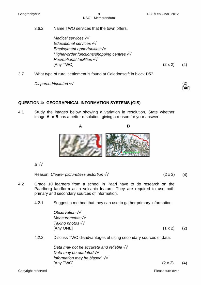
QUESTION 4: GEOGRAPHICAL INFORMATION SYSTEMS (GIS) 4.1 Study the images below showing a variation in resolution. State whether
image A or B has a better resolution, giving a reason for your answer.
A B
B √√ Reason: Clearer picture/less distortion √√ (2 x 2)
(4)
4.2 Grade 10 learners from a school in Paarl have to do research on the
Paarlberg landform as a volcanic feature. They are required to use both primary and secondary sources of information.
4.2.1
Suggest a method that they can use to gather primary information. Observation √√ Measurements √√ Taking photos √√ [Any ONE] (1 x 2)
(2)
4.2.2
Discuss TWO disadvantages of using secondary sources of data. Data may not be accurate and reliable √√ Data may be outdated √√ Information may be biased √√ [Any TWO] (2 x 2)
(4)
kerrygsilis
Typewritten Text
Want a tutor to help you ace this exam? www.teachme2.co.za/matric
Geography/P2 10 DBE/Feb.–Mar. 2012 NSC – Memorandum
Copyright reserved
4.3
Give an example of a point, line and polygon features respectively, evident in block H10. Point: Trig station/Spot height/Houses √√ [Any ONE] Line: Road/River √√ [Any ONE] Polygon: Dam √√ (3 x 2)
(6)
4.4 During major natural disasters, accessibility to the Paarl Valley is limited in
order to determine the extent of the damage.
4.4.1
Give an example of a remote sensing device that can be used to capture the extent of the damage. Satellites √√ (1 x 2)
(2)
4.4.2
State ONE advantage of remote sensing. Data can be collected for inaccessible areas √√ Large areas can be captured as images √√ Can be made available at short notice especially in times of disaster management √√ It can be used to track changes and development in an area over time. √√ [Any ONE] (1 x 2)
(2) [20]
TOTAL: 100