GEOGRAPHY P1 ANNEXURE - Mindset...
12
Copyright reserved Please turn over NATIONAL This annexure consists of 12 pages. GEOGRAPHY P1 EXEMPLAR 2012 ANNEXURE NATIONAL SENIOR CERTIFICATE GRADE 10
Transcript of GEOGRAPHY P1 ANNEXURE - Mindset...

Copyright reserved Please turn over
NATIONAL
This annexure consists of 12 pages.
GEOGRAPHY P1
EXEMPLAR 2012
ANNEXURE
NATIONAL SENIOR CERTIFICATE
GRADE 10
Geography/P1 2 DBE/2012 NSC – Grade 10 Exemplar (Annexure)
Copyright reserved Please turn over
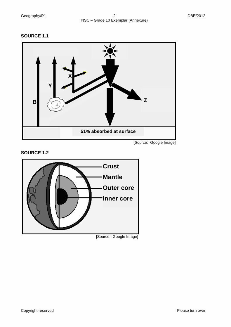
SOURCE 1.1
[Source: Google Image] SOURCE 1.2
[Source: Google Image]
A
B Z
Y
X
51% absorbed at surface
Crust Mantle Outer core Inner core
Geography/P1 3 DBE/2012 NSC – Grade 10 Exemplar (Annexure)
Copyright reserved Please turn over
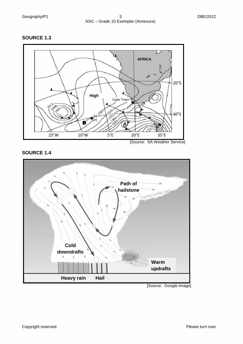
SOURCE 1.3
[Source: SA Weather Service] SOURCE 1.4
[Source: Google Image]
A B
25°W 10°W 5°E 20°E 35°E
20°S
40°S
Warm updrafts
Cold downdrafts
Path of hailstone
Heavy rain Hail
C
B
AFRICA
High Cape Town

Geography/P1 4 DBE/2012 NSC – Grade 10 Exemplar (Annexure)
Copyright reserved Please turn over
SOURCE 1.5
[Source: Google] SOURCE 1.6
MOUNT PELEE ERUPTS
The town of St. Pierre lay peacefully at the foot of Mount Pelee in the West Indies. Mount Pelee towered over the town. Although the people knew that Mount Pelee was a volcanic mountain, few looked upon it with concern. The young people laughed at the elders when they spoke about it erupting 50 years before. Yes, Old Pelee was dead, no longer to be feared, but a friend. Suddenly in the spring of 1902 Mount Pelee came to life. There was a terrible explosion that rocked the town and tore a gigantic hole in the side of the mountain. A flood of boiling mud and glowing cinders swept down the mountainside into the town. In a matter of minutes the town was on fire and half buried. Ships in the harbour caught on fire and people burnt to death. The town remains in ruins.
[Source: Google]
Ash cloud
Pyroclastic flow
Crater Main vent
Lava flow
Magma chamber
Secondary vent
Secondary cone
Volcanic bombs

Geography/P1 5 DBE/2012 NSC – Grade 10 Exemplar (Annexure)
Copyright reserved Please turn over
SOURCE 2.2
[Source: Google Image] SOURCE 2.3
BEEF CATTLE CAUSE MORE EMISSIONS THAN CARS – REPORT by Ben Kage Rising petrol prices and global warming issues have spurred an interest in clean cars, but a report by the United Nations suggests that the real culprit is not the car, but the cow. The world's surging cattle herds are the greatest threat to the planet. 'Cattle farming not only destroys rainforests, uses enormous quantities of fresh water and results in the inhumane treatment of animals, it also increases the destruction of the planet's atmosphere,' Adams said. The clearing of vegetation for grazing, the use of fertilisers for feed, and transportation of the product is responsible for 9 percent of all carbon dioxide emissions. While carbon dioxide is the most common greenhouse gas, the gasses released from cattle herds and manure emit more than one-third of all methane, a greenhouse gas that warms the world 20 times faster than carbon dioxide. Livestock also produce ammonia, a primary cause of acid rain. Cattle emit 18 percent of the greenhouse gases that cause global warming, which beats the emissions from all transportation combined. It is also a major cause of deforestation, the report states, as a fifth of the world's pastures are being turned into deserts by overgrazing. Cows also require a massive amount of water – it takes about 9 900 litre of water to produce a little less than one litre of milk.
[Source: Google]
50 km
82 km
10 km
Cirrus
Weather satellites
C
B A
Stratosphere
Earth
Geography/P1 6 DBE/2012 NSC – Grade 10 Exemplar (Annexure)
Copyright reserved Please turn over
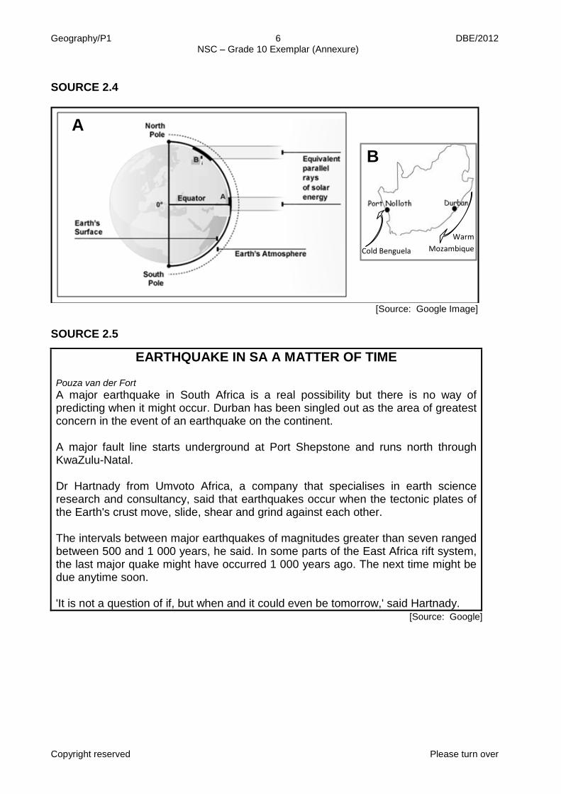
SOURCE 2.4
[Source: Google Image] SOURCE 2.5
EARTHQUAKE IN SA A MATTER OF TIME Pouza van der Fort A major earthquake in South Africa is a real possibility but there is no way of predicting when it might occur. Durban has been singled out as the area of greatest concern in the event of an earthquake on the continent. A major fault line starts underground at Port Shepstone and runs north through KwaZulu-Natal. Dr Hartnady from Umvoto Africa, a company that specialises in earth science research and consultancy, said that earthquakes occur when the tectonic plates of the Earth's crust move, slide, shear and grind against each other. The intervals between major earthquakes of magnitudes greater than seven ranged between 500 and 1 000 years, he said. In some parts of the East Africa rift system, the last major quake might have occurred 1 000 years ago. The next time might be due anytime soon. 'It is not a question of if, but when and it could even be tomorrow,' said Hartnady.
[Source: Google]
A
B
Warm Mozambique Cold Benguela

Geography/P1 7 DBE/2012 NSC – Grade 10 Exemplar (Annexure)
Copyright reserved Please turn over
SOURCE 2.6
[Source: Google Image] SOURCE 3.2
[Source: Google Image]
G
F E
D C
B
A Trees
Neck
Dyke
Dyke
Sill
Stock

Geography/P1 8 DBE/2012 NSC – Grade 10 Exemplar (Annexure)
Copyright reserved Please turn over
SOURCE 3.3
[Source: Google Image] SOURCE 3.4
[Source: Google Image]
We have serious problems!
We have serious problems!
Farm
City
Low

Geography/P1 9 DBE/2012 NSC – Grade 10 Exemplar (Annexure)
Copyright reserved Please turn over
SOURCE 3.5
[Source: Google Image] SOURCE 3.6 Source: Google
[Source: Daily News, June 2011]
RIPPLE EFFECT OF EXPLOITING FISH STOCKS Kamcilla Pillay Marine biologists predict that fish stocks will be depleted by 2050, upsetting the delicate balance of the world's oceans. The loss of fish will have a domino effect (an effect on one level will affect the next level) where other species are affected, for example whales will have a shortage of food. This is made worse by the increasing death of coral reefs. Corals store carbon, and this will have an impact on the climate. There is a serious need to investigate other means of harvesting fish.
Oceans are full of wonders. It is very important to the survival of humans.
What about the exploitation of
oceans by humans?
Illegal dumping Oil leaks

Geography/P1 10 DBE/2012 NSC – Grade 10 Exemplar (Annexure)
Copyright reserved Please turn over
SOURCE 4.1
[Source: Google Image] SOURCE 4.2
oo [Source: Google Image]
A B

Geography/P1 11 DBE/2012 NSC – Grade 10 Exemplar (Annexure)
Copyright reserved Please turn over
SOURCE 4.3
HIV/AIDS IN SOUTH AFRICA
Among the estimated 40 million people with HIV/Aids around the world at the end of 2001, the cast majority, 28 million, lived in sub-Saharan Africa. The virus has spread at such a rapid rate in South Africa that the country is home to more HIV-positive people than any other nation.
Deaths from HIV/Aids
HIV/Aids killed more people in South Africa during 2001 than in any other country. Deaths from HIV/Aids, in thousands:
Child mortality
Child mortality in South Africa as a result of HIV/Aids is likely to grow even worse this decade. Deaths per 1 000 births by age 5:
With Without Total HIV/Aids HIV/Aids
[Source: Google] SOURCE 4.5
[Source: Sunday Times, January 2012]
HUNDREDS LEFT DESTITUTE
Shocked residents started counting the cost of this week's floods in the Limpopo town of Hoedspruit. Hundreds of families have been left destitute after severe flooding in the area. Trees were uprooted and cars swept away like toys. A large portion of a road washed away when a dam wall broke. Electricity and water supplies were disrupted and farms destroyed. 600 mm of rain fell in 48 hours. This has been attributed to a tropical low-pressure system in the area. Major relief efforts are under way.

Geography/P1 12 DBE/2012 NSC – Grade 10 Exemplar (Annexure)
Copyright reserved
SOURCE 4.6
DEMAND FOR WATER: 1996 AND 2030
SECTOR % CONTRIBUTION
TO GDP
1996 (106 m3 a-1)
2030 (106 m3 a-1)
PERCENTAGE INCREASE
Urban and Domestic - 2 171 6 936 219,5%
Mining and Industrial 37% 1 598 3 380 111,5%
Irrigation and Forestry 6% 12 344 15 874 28,6%
Environmental - 3 932 4 225 7,5%
TOTAL - 20 045 30 415 51, 7%
[Source: Google]