
Geography in Action - Chapter 11dskellystpaulsgs.weebly.com/uploads/5/0/5/0/5050885/rivers.pdf ·...
31
Chapter 11 Rivers: Shaping our landscape
Transcript of Geography in Action - Chapter 11dskellystpaulsgs.weebly.com/uploads/5/0/5/0/5050885/rivers.pdf ·...

Chapter 11
Rivers: Shaping our landscape

Learning outcomes
In this presentation you will learn:
• Common terms associated with rivers
• About the three stages of a river
• About the processes of river erosion
• About the processes of river transportation
• About features formed by river erosion and deposition
• How human activity affects rivers

Common terminology
Source The start of a river
Course The route a river takes
Confluence The point at which two rivers join together
Tributary A smaller river that flows into a larger river
Mouth The end of a river – enters the sea
Drainage
basin
Area of land drained by a river
Watershed Highland surrounding drainage basin
Estuary Part of river mouth that is tidal
Exam hint: You need to understand common
terminology associated with rivers.

Common terminology
Describe each term
above.

Stages of a river
Three stages:
Upper or
youthful stage
Middle or
mature stage
Lower or old
stage
Exam hint: You must know the three stages of a river.

Stages of a river Upper or youthful
stage
Middle or mature
stage
Lower or old stage
Steep, fast-flowing
Little water
Steep, V-shaped
valley
Narrow, shallow
channel
High bed load (larger
rocks)
Starts to slow down
More water
Still eroding
Open, gently sloping
valley with flood plain
Wider, deeper
channel
More suspended
sediment
Slow-moving river
Much more water
Depositing, not
eroding
Open, gently slowing
valley with flat and wide
flood plain
Very wide, deep
channel
Suspended sediment
Features:
V-shaped valleys,
interlocking spurs,
waterfalls
Features:
Meanders, oxbow lakes
Features:
Flood plains, levees
Exam hint: You need to be able to describe a river at each stage.

Stages of a river
Name two features
associated with each
stage.

The work of rivers
Shapes the
landscape:
Erosion
River wears the
landscape away
Transportation
River carries the
material it has
eroded
Deposition
River drops off
material it was
carrying
Exam hint: You need to understand how a river shapes the landscape.

River erosion – processes
Hydraulic
action
Force of moving water wears away
river bed
Abrasion Stones carried by water wear away
banks
Attrition Stones are worn down as they hit
each other
Solution Rocks (e.g. limestone) are
dissolved by acids in water
Exam hint: You need to be able to describe how a river erodes.

River transportation
• Transportation occurs
in a number of ways
• Method depends on:
size of material
size and speed of river
• Material transported
by river is its load
Exam hint: You need to know how a river transports its load.

River transportation – methods
Rolling Large stones are rolled along river
bed – known as traction
Bouncing Smaller pebbles are bounced along
river bed – known as saltation
Suspension Light materials float along in water
Solution Materials dissolve and are carried
along

River deposition
• Shapes land by leaving sediment in new places
• Makes new land or adds to existing
• Causes of deposition:
Reduction in river’s speed – where a river enters a
sea or lake or during dry spell
Increase in load size – when tributary joins or after
heavy rain
Reduction in river’s volume – during dry spell
When gradient levels off – when river reaches flatter
land

The youthful stage (upper course)
• River cuts downwards
• Gradient is steep and river channel narrow
• Vertical erosion
V-shaped valleys
Interlocking spurs
Waterfalls
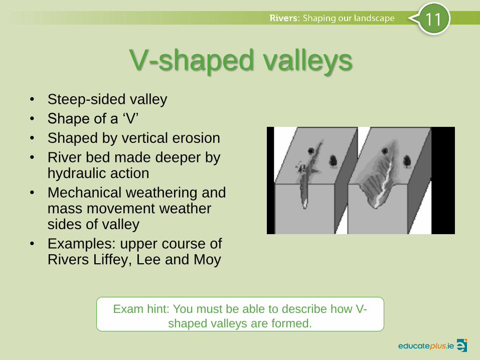
V-shaped valleys • Steep-sided valley
• Shape of a ‘V’
• Shaped by vertical erosion
• River bed made deeper by hydraulic action
• Mechanical weathering and mass movement weather sides of valley
• Examples: upper course of Rivers Liffey, Lee and Moy
Exam hint: You must be able to describe how V-
shaped valleys are formed.

Interlocking spurs
• Areas of high ground
• Jut out at both sides of V-shaped valley
• River winds and bends around hard rock as it erodes
• Still erodes vertically
• Creates interlocking spurs
• Example: Upper course of Rivers Barrow and Slaney
Exam hint: You must be able to
describe how interlocking spurs are
formed.

Waterfalls
• Vertical drop in course of river – youthful stage
• Band of hard rock across band of soft rock
• Soft rock eroded quicker – drop is created
• Material creates a plunge pool at base
• Enlarges over time
• Hydraulic action and abrasion cause undercutting
• Creates overhang – eventually collapses
• This is repeated and waterfall retreats over time
Exam hint: You need to know how waves are formed.

Waterfalls
Name another example of a
waterfall.

The mature stage (middle course)
• River has more energy
• Higher volume of water
• Tributaries or other rivers have joined
• Gradient is gentle
• Lateral erosion has widened river channel
• River channel has deepened
• River carrying more material

Meanders
• Curves or bends
• River erodes laterally
• Right then left
• Forms large bends
• Horseshoe-like loops
• Meanders formed by deposition and erosion
• Hydraulic action erodes outside of bend
• Material deposited on inside of bend
• Example: Middle course of River Shannon
Exam hint: You must be able to describe how
meanders are formed.

Oxbow lakes • Horseshoe-shaped lake
• Meander cut off from river
• Neck of meander becomes tight
• During flood – more discharge
• River breaks through
• Loop cut off – sediment dropped at entrance
• Forms oxbow lake
• Dries up – oxbow scar
• Examples: River Liffey and River Moy
Exam hint: You must be able to describe how
oxbow lakes are formed.

Oxbow lakes [Insert
11.21.01
11.21.02]

The old stage (lower course)
• Slow-moving river
• Much more water
• Deposition, not erosion
• Gently sloping valley
• Very wide and very deep channel
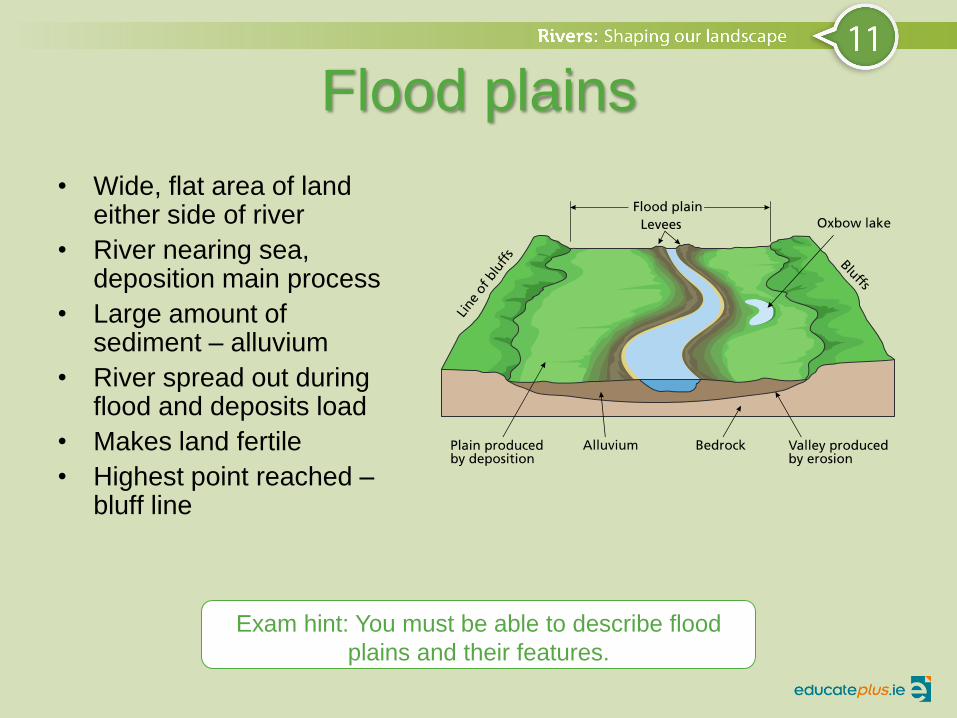
Flood plains
• Wide, flat area of land either side of river
• River nearing sea, deposition main process
• Large amount of sediment – alluvium
• River spread out during flood and deposits load
• Makes land fertile
• Highest point reached – bluff line
Exam hint: You must be able to describe flood
plains and their features.

Flood plain
• Examples: Lower course of River Moy and River Liffey

Levees
• Build up of alluvium on banks of river
• Caused by floods
• Low flow – materials deposited on river bed
• Flood – water leaves channel and deposits heavier material on banks
• After many floods – river bank builds on both sides
• Examples: Mature stage of Rivers Liffey and Moy
What are artificial levees and
what are they used for?
Exam hint: You need to know
how waves are formed.

Deltas
• Triangular/ fan-shaped – at mouth of river
• Features of deposition – old stage
• River mouth choked with sediment
• River channel splits into smaller channels
• Form under certain conditions:
Transporting large amount of sediment
Sea – small tidal range, weak currents
Shallow at mouth of river
Examples: Mississippi River in USA and the Nile delta in
Africa
Exam hint: You need to know how waves are formed.

Human activities and rivers
• Humans use rivers in variety of ways
• Interactions can be beneficial or harmful
• Interactions include:
Transport
Tourism
Fishing
Settlement
Pollution
Flooding
Hydroelectric power (HEP)

Human activities and rivers
Transport Used to transport people and goods, e.g. Limerick has port
function, River Rhine is important transport route in Europe
Tourism Use rivers for cruising and fishing, e.g. Carrick-on-Shannon
and Athlone on River Shannon are tourist destinations
Fishing Popular with anglers, many popular for salmon fishing, e.g.
River Moy
Settlement Settlement along river banks – provides food, water and
transport
Pollution Farming – spread slurry; domestic – waste material from septic
tanks; industrial – factories dump waste
Flooding Cutting down trees – surface run-off and erosion, can lead to
deposition, river rises and bursts banks
HEP HEP stations built using dams, large concrete wall to control
flow of river, can have both positive and negative impact
Exam hint: You need to be able to describe how human
interactions impact on rivers.

HEP: positive and negative aspects
Positive aspects Negative aspects
Generate cheap, clean,
renewable electricity
Water builds up in
reservoir – water supply
Reservoir can be used
for leisure activities –
fishing and water sports
Creation of reservoir –
can lose agricultural land
Families need to be
relocated
New roads and bridges
have to be built
Fish stocks can be
affected
Exam hint: You may be asked to discuss the positive and
negative aspects of HEP.

Inniscarra, Co. Cork
• Location: Inniscarra and
Carrigadrohid
• Technology: Hydro
• Capacity: 27 MW
• Commissioned: 1957
• Part of Lee Hydroelectric
Scheme
• Located west of Ballincollig
• Buttress dam, 44 m
• Parts of Lee valley flooded to
create reservoirs
• Inniscarra – 530 h (5 km²)
• 40 k of bank can be fished
Exam hint: You need to be able to describe a HEP scheme you have studied.

Sample answer
i) Rivers are often used to generate hydroelectric power. Describe one positive and one negative effect of a HEP scheme you have studied.
Answer: Positive – Inniscarra reservoir is used for angling.
Negative – Agricultural land was lost when the Lee valley was flooded to create reservoirs for generating electricity.