Geography & Natural Resources
18
Geography & Natural Resources Rajasthan Public Service Commission Assistant Engineer Examination Comprehensive Theory with Practice questions and Previous year solved questions Publications
Transcript of Geography & Natural Resources

Geography &Natural Resources
Rajasthan Public Service Commission
Assistant Engineer Examination
Comprehensive Theory with Practice questions and Previous year solved questions
Publications

MADE EASY PUBLICATIONS has taken due care in collecting the data and providing the solutions, before publishing this book. Inspite of this, if any inaccuracy or printing error occurs then MADE EASY PUBLICATIONS owes no responsibility. MADE EASY PUBLICATIONS will be grateful if you could point out any such error. Your suggestions will be appreciated.
© All rights reserved by MADE EASY PUBLICATIONS. No part of this book may be reproduced or utilized in any form without the written permission from the publisher.
MADE EASY Publications
Corporate Office: 44-A/4, Kalu Sarai (Near Hauz Khas Metro Station), New Delhi-110016E-mail: [email protected]: 011-45124660, 08860378007
Visit us at: www.madeeasypublications.org
RPSC Assistant Engineer Examination:Geography & Natural Resources© Copyright, by MADE EASY Publications.
All rights are reserved. No part of this publication may be reproduced, stored in or introduced into a retrieval
system, or transmitted in any form or by any means (electronic, mechanical, photo-copying, recording or
otherwise), without the prior written permission of the above mentioned publisher of this book.
First Edition: 2018
Publications

Preface
The compilation of this book Geography & Natural Resources was
motivated by the desire to provide a concise book which can benefit
students who are preparing for Rajasthan Public Service Commission
(RPSC) Assistant Engineer Examination.
It would be worth mentioning that the entire syllabus of General Studies
for RPSC Assistant Engineer Examination consists of five subjects
namely Current Affairs, History & Culture, General Science, G.K. & Economic Developments with special
reference to Rajasthan, and Geography & Natural Resources. The textbook of all five subjects to be launched
separately. These all books will have special focus to Rajasthan which will help the aspirants immensely.
This particular textbook provides all the requirements of the students, i.e. comprehensive coverage of theory,
fundamental concepts and objective type questions articulated in a lucid language. The concise presentation
will help the readers grasp the theory of this subject with clarity and apply them with ease to solve objective
questions quickly. This book not only covers the syllabus of RPSC Assistant Engineer Examination in a holistic
manner but is also useful for other examinations conducted by RPSC. All the topics are given the emphasis
they deserve so that mere reading of the book clarifies all the concepts. We have put in our sincere efforts
to present detailed theory and MCQs without compromising the accuracy of answers.
Our team has made their best efforts to remove all possible errors of any kind. Nonetheless, we would highly
appreciate and acknowledge if you find and share with us any printing and conceptual errors.
It is impossible to thank all the individuals who helped us, but we would like to sincerely thank all the authors,
editors and reviewers for putting in their efforts to publish this book.
With Best Wishes
B. Singh
CMD, MADE EASY Group

Indian Geography
Contents
Part-I 1-72
iv
Chapter 1General Aspects of Geography ..................... 2
Latitude ........................................................................ 2
Longitude ..................................................................... 2
Motions of Earth ........................................................... 3
Structure of Earth ......................................................... 3
Formation of Continents ............................................... 4
Earthquake................................................................... 4
Volcanoes .................................................................... 5
Chapter 2India: General Facts ........................................ 7
Chapter 3Physical Geography of India .......................11
Introduction ................................................................ 11
Physiographic Divisions of India ................................ 11
The Peninsular Plateau .............................................. 13
The Great Plain of India ............................................. 14
The Coastal Plains ..................................................... 15
The Islands of India ................................................... 16
Chapter 4Drainage System of India ............................17
Introduction ................................................................ 17Himalayan Rivers ....................................................... 17Peninsular Rivers ....................................................... 18Lakes ......................................................................... 20Power Projects in India .............................................. 21
Chapter 5Climate of India ..............................................24
Introduction ................................................................ 24
Characteristics of Indian Monsoon ............................ 24
Annual Rainfall ........................................................... 26
Chapter 6Soils of India ....................................................28
Introduction ................................................................ 28
Classification of Soils ................................................. 28
Reasons for the Infertility of Soils ............................... 29
Chapter 7Forests of India ...............................................31
Introduction ................................................................ 31Forests of India .......................................................... 31Tropical Evergreen Forests ........................................ 31Tropical Moist or Wet Deciduous Forests ................... 32Tropical Dry Deciduous Forests ................................. 32Dry Forests or Arid Forests ........................................ 32Mountainous Forest or Himalayan Forests ................ 33
Mangrove Forests ............................................................ 33
Chapter 8Population Geography of India ..................34
Introduction ................................................................ 34Census 2011 .............................................................. 34Growth Rate ............................................................... 35Sex Ratio .................................................................... 36Literacy ...................................................................... 36Population Density ..................................................... 37Urbanisation ............................................................... 37
Races and Tribes of India .......................................... 39
Chapter 9Industry in India ............................................41
Iron and Steel Industry ............................................... 41
Cotton Textile Industry ............................................... 41
Woollen Textile Industry ............................................. 42
Silk Textiles Industry ................................................... 42
Jute Textiles Industry ................................................. 42
Sugar Industry ........................................................... 42
Tea Industry ............................................................... 43
Paper Industry ........................................................... 43

World Geography
v
Cement Industry ........................................................ 44
Leather Goods Industry ............................................. 44
Rubber Industry ......................................................... 44
Railway Engineering .................................................. 44
Shipping Industry ....................................................... 45
Air Craft Industry ........................................................ 45
Heavy Electrical Equipment ....................................... 45
Pharmaceuticals and Drugs....................................... 46
Chemical Fertilizer Industry ....................................... 46
Chapter 10Agriculture in India ......................................48
Sources of Irrigation in India ...................................... 48
Trial Methods to Improve Productivity ........................ 48
Agriculture in India ..................................................... 49
Jhoom or Shifting Agriculture ..................................... 51
Chapter 11Minerals in India ............................................52
Introduction ................................................................ 52
Coal ........................................................................... 52
Petroleum or Mineral Oil ............................................. 53
Oil Refining ................................................................ 53
Natural Gas resource ................................................. 54
Iron Ore ..................................................................... 54
Manganese ................................................................ 55
Bauxite (Aluminium) ................................................... 55
Copper ....................................................................... 55
Diamond .................................................................... 56
Gold ........................................................................... 56
Silver .......................................................................... 56
Lead and Zinc ............................................................ 56
Mica ........................................................................... 56
Gypsum ..................................................................... 57
Graphite ..................................................................... 57
Tin ............................................................................ 57
Uranium ..................................................................... 57
Chromite .................................................................... 57
Thorium ...................................................................... 57
Chapter 12Transport and Communication .................58
Road Transport .......................................................... 58
Rail Transport ............................................................. 60
Water Transport .......................................................... 61
Air Transport .............................................................. 62
Some Important Airports of India ............................... 63
Practice QuestionsPractice Questions ...................................................... 64
Part-II 73-110
Chapter 1World: General Facts.....................................74
Chapter 2World: Physical...............................................76
Africa ......................................................................... 76
North America ............................................................ 77
South America ........................................................... 78
Europe ....................................................................... 79
Asia ............................................................................ 81
Australia ..................................................................... 83
Antarctica ................................................................... 84
Chapter 3World: Climatic Regions ..............................85
Equatorial Climatic Region: (10°N To 10°S) ............... 85
The Savanna or Sudan Climate: (10° to 20°N & S) ..... 85
The Hot Desert and Mid-Latitude Desert Climate:
(20° to 30°N & S) ........................................................ 86
The Warm Temperate Western Margin
(Mediterranean) Climate: (30° to 40°N & S) ............... 86
Temperate Grasslands (Steppe Climate):
(40° to 55°N & S) ........................................................ 87
Cool Temperate Continental (Taiga or
Siberian Climate): (55° to 70°N) ................................. 87

vi
Tundra Climate: (70° to 90°N) .................................... 88The Tropical Monsoon & Tropical Marine Climate ...... 88The Warm Temperate Eastern Margin (China Type ) Climate ................................................ 88The Cool Temperate Western Margin
(British Type Climate) ................................................. 89
Chapter 4Oceans ...............................................................90
Introduction ................................................................ 90Salinity ....................................................................... 90Currents of North Atlantic Ocean ............................... 91Currents of South Atlantic Ocean ............................... 91Currents of North Pacific Ocean ................................ 91Currents of north Indian Ocean .................................. 92Currents of South Indian Ocean ................................. 92
Major Fishing Grounds of the World ........................... 92
Chapter 5Atmosphere .....................................................94
Composition of Atmosphere ....................................... 94
Structure of Atmosphere ............................................ 94
Clouds ....................................................................... 95
Rainfall ....................................................................... 96
Pressure Belts ............................................................ 97
Wind belts (Planetary Winds) ..................................... 98
Solar Constant ........................................................... 98
Cyclones .................................................................... 99
Chapter 6World: Mineral Resources ........................ 100
Types of Economies ................................................. 100Mineral Resources ................................................... 100Iron Ore .................................................................... 100Aluminium (Bauxite) ................................................. 100Copper ..................................................................... 101Zinc .......................................................................... 101Manganese .............................................................. 101Lead ......................................................................... 101Tin .......................................................................... 101Gold ......................................................................... 101Silver ........................................................................ 101Diamond .................................................................. 101Coal ......................................................................... 101Mineral Oil ................................................................ 101Nuclear Energy ....................................................... 102Natural Gas .............................................................. 102Major Continental Railways of World ........................ 102
Practice QuestionsPractice Questions ....................................................103
Geography of RajasthanPart-III 111-186
Chapter 1General Aspects of Rajasthan ................. 112
Geographical Situations ........................................... 112
Chapter 2Physical Aspects of Rajasthan ................. 115
Introduction .............................................................. 115
Western Sandy Plain ................................................ 115
Aravalli Range and Hilly Region ............................... 117
Eastern Plain Region ................................................ 120
South-Eastern Plateau of Rajasthan
(Hadoti Plateau) ....................................................... 121
Chapter 3Climate of Rajasthan .................................. 122
Introduction .............................................................. 122
Climate of Rajasthan with reference to
three seasons .......................................................... 122

vii
Drought and famine in Rajasthan ............................. 124
Impact of Famine ..................................................... 126
Chapter 4Drainage System & Lakes of Rajasthan ... 127
Introduction .............................................................. 127
Arabian Sea Drainage System ................................. 127
Bay of Bengal Drainage System .............................. 129
Rivers of Inland Drainage ........................................ 130
Lakes of Rajasthan................................................... 132
Chapter 5Soil of Rajasthan ......................................... 136
Introduction .............................................................. 136
Chapter 6Mines and Minerals of Rajasthan ........... 138
Introduction .............................................................. 138
Spatial distribution of minerals ................................. 140
Metallic Minerals ...................................................... 140
Industrial & Non-metallic Minerals ........................... 141
Electronic & Nuclear Minerals .................................. 142
Gem-stones and Abrasives ...................................... 143
Fertilizer Minerals ..................................................... 143
Minerals of Chemical Industry ................................. 144
Minor Minerals ......................................................... 144
Main Garnet deposits area....................................... 143
Miscellaneous groups of Mineral ............................. 145
Fuel Minerals ............................................................ 146
Chapter 7Natural Vegetation of Rajasthan ............ 147
Introduction .............................................................. 147
Division of forest in Rajasthan .................................. 147
Fiber providing species ........................................... 148
Threatened Species of Vegetation in Rajasthan ....... 149
Important Government initiatives for
conservation of natural Vegetation ........................... 150
Rajasthan-Eco-Tourism Policy .................................. 150
Chapter 8Wildlife Protected Areas .......................... 152
Wildlife of Rajasthan ................................................ 152
Threatened Species of Rajasthan ............................ 152
Wildlife Protected Areas ........................................... 154
Wildlife Sanctuaries of Rajasthan ............................. 156
Conservation Reserves ............................................ 157
Community Reserve ................................................. 157
Chapter 9Power Resources of Rajasthan ................ 158
Introduction .............................................................. 158
Thermal Power Plants of Rajasthan .......................... 159
Hydro Power Station of Rajasthan ............................ 160
Rajasthan Atomic Power Project .............................. 160
Non-conventional sources of Power ......................... 161
Chapter 10Natural Vegetation of Rajasthan ............ 163
Introduction .............................................................. 163
Livestock Population Growth .................................... 163
Livestock contribution in Rajasthan ......................... 165
Main Activities and Programmes of the Department ... 168
State Level Cattle Fairs ........................................... 170
Chapter 11Population of Rajasthan ........................... 172
Introduction .............................................................. 172
Urban and Rural Population of Rajasthan ............... 173
Sex Ratio of Rajasthan ............................................. 174
Literacy Rate in Rajasthan ....................................... 174
Scheduled Caste and Scheduled Tribes .................. 175
Poverty in Rajasthan ................................................ 176
Practice QuestionsPractice Questions ....................................................177

Ecology of IndiaPart-IV 187-248
Chapter 1Basics of Ecology ........................................ 188
Introduction .............................................................. 188
Important Terms related to Ecology............................ 188
Biogeographic Regions in India ............................... 190
Chapter 2Ecosystem ..................................................... 192
Introduction .............................................................. 192
Components of Ecosystem ...................................... 192
Types of Ecosystem ................................................. 195
Marine Ecosystem .................................................... 197
Functions of an Ecosystem ...................................... 198
Nutrient Cycle .......................................................... 200
Ecological Pyramids ................................................ 201
Pollutant and Trophic Level ...................................... 203
Biotic Interaction ...................................................... 205
Ecological Succession ............................................. 205
Threatened Ecosystems ........................................... 207
Mangroves ............................................................... 208
Coral Deposits ......................................................... 209
Chapter 3Biodiversity of India .................................. 211
Introduction .............................................................. 211
Biodiversity Hotspots ............................................... 212
Loss of Biodiversity .................................................. 213
Conservation of Biodiversity .................................... 213
Wildlife Conservation Projects in India ..................... 217
Wildlife (Protection) Act, 1972 .................................. 223
Legislative Steps taken by Union Government
to conserve Biodiversity ........................................... 223
Indian Organisations Related to Biodiversity ........... 224
Chapter 4Climate Change ............................................ 225
Introduction .............................................................. 225
Global Warming ....................................................... 225
Blue Carbon Initiative ............................................... 228
Varies Green House Gases ...................................... 226
Global Warming Potential of Gases ......................... 227
Mitigation Strategies ................................................ 228
Chapter 5Climate Change Organisations ................ 230
UNFCCC .................................................................. 230
India and Climate Change ....................................... 233
National Action Plan on Climate Change ................. 264
Green Building and GRIHA ...................................... 235
Chapter 6Environmental Conventions .................... 236
Conventions related to Environment & Biodiversity ..... 236
Conventions on Biodiversity ..................................... 236
Conservation for Land .............................................. 238
Atmosphere ............................................................. 238
Hazardous Material .................................................. 239
Agriculture ............................................................... 240
Practice QuestionsPractice Questions ....................................................241
Previous Year QuestionsPrevious Year Questions ..........................................247
viii

PART
INDIANGEOGRAPHY

Latitude• It is the angular distance of a point on the earth’s
surface, measured in degrees from the centre of the earth. It varies from 0 to 90° North and 0 to 90° South.
• Latitudes are circular lines which are parallel to the equator, which lies midway between the poles. Hence, these lines are called parallels of latitude. The latitudes are also called as temperature coordinates because with the increase in latitudinal distance towards the poles, the temperature reduces.
• The midday sun is exactly overhead at least once a year on all latitudes in between the Tropic of Cancer and the Tropic of Capricorn. This area, therefore receives the maximum heat and is called the Torrid Zone (or Tropical Zone).
• The areas bounded by the Tropic of Cancer and the Arctic Circle in the northern hemisphere, and the Tropic of Capricorn and the Antarctic Circle in the southern hemisphere, have moderate temperature, hence called Temperate Zones (or Mild Zone).
N.P.
NorthFrigid Zone
23½°S
SouthFrigid Zone
S.P.
South Temperate Zone
Antarctic Circle
Tropic of Capricorn
Torrid Zone
Equator
North Temperate Zone
Torrid Zone
Arctic Circle
Tropic of Capricorn 23½°N
0°
66½°S66½°S
23½°S
0°
23½°N
66½°N66½°N
• Areas bounded by the Arctic Circle and North Pole, and the Antarctic Circle and South pole are
called Frigid Zones. These zones are very cold as the sun does not rise above the horizon.
Longitude• It is an angular distance measured in degrees along
the equator east or west of the Prime Meridian (0°). It varies from 0 to 180° E and 0 to 180° W. It is also called as time coordinates.
• Meridians are a series of semicircles that run from pole to pole passing through the equator.
• Longitudes are imaginary lines joining north pole with south pole.
PR
IME
ME
RID
IAN
15°W3
0°W
45°W
60°W
75°W
90°W
0° 1
5°E
45°E
60°E
75°E
90°E
30°E
N.P.
• The Prime Meridian is at 0° and is known as the Greenwich line as it passes through Greenwich near London, where the British Royal Observatory is located.
• Longitudes have one very important function i.e. they determine Local Time in relation to Greenwich Mean Time (GMT).
• Maximum distance between two longitude lies over equator and minimum distance over poles, where they converge.
• In India, the longitude of 82½° E is treated as the Standard Meridian. The Local Time at meridian is taken as the Standard Time for the whole country. It is known as the Indian Standard Time (IST).
cancer
General Aspectsof Geography 1

International Date Line• It is an imaginary line drawn at 180° longitude,
avoiding the continuous land parts.• International Date Line passes through Arctic
Ocean, Bering Strait, Pacific Ocean, Antarctica, Fiji, Tonga and other islands.
• It is also the longitude where the date changes by exactly one day when it is crossed. If a traveller crossing the date line from east to west, he loses a day and while crossing the date line from west to east, he gains a day.
Do You Know?
• The midday sun never shines overhead on any latitude beyond the Tropic of Cancer and the Tropic of Capricorn.
• 180° East and 180° West meridians are the same line which is called the International Date Line.
• Russia has 11 and China has 5 times zones, whereas USA and Canada both have six time zones (the Atlantic, Eastern, Central, Mountain, Newfoundland and Pacific time zones).
Motions of Earth• The earth is a planet of the solar system. It is not
static but has two types of motions: (a) Rotational Motion (b) Revolutional (or Orbital) Motion
(a) Rotation of Earth• Rotation is a spinning of earth continuously on
its own axis from west to east once in every 24 hours, causing day and night.
• Rotation is also responsible for generation of centrifugal force which is maximum over equator. This force is responsible for equatorial buldging and polar flattening.
(b) Revolution of Earth• The earth also revolves around the sun in an orbit
once in about 365 days and 6 hours, causing formation of seasons and the year. This motion is called Revolution of earth (also called annual movement).
Varying lengths of Day and Night• The axis of the earth is inclined to the plane of
earth’s orbit at an angle of 66½° giving rise to different seasons and varying lengths of day & night.
• The sun is vertically overhead at the equator on 21 March and 21 September and these two days are termed as Equinoxes (equal length of day & night in both the hemisphere).
• On 21 June, the sun is vertically overhead at the Tropic of Cancer (23½° N). This is known as summer solstice, when the northern hemisphere will have its longest day and shortest night.
• On 22 December, the sun is vertically over head at the Tropic of Capricorn (23½° S). This is known as winter solstice, when the southern hemisphere will have its longest day and shortest night.
• Beyond the Arctic Circle (66½° N) and Antarctic Circle (66½° S) darkness lasts for 6 months and daylight is continuous for the remaining 6 months.
Structure of Earth
• The earth as a whole has been divided into three broad zones:
1. Crust (SIAL) : The outermost layer of earth is called as crust. It is free to drift over a layer called Asthenosphere.• Crust comprises two distinct parts, the upper
crust or continents made up of granitic rocks (silica and aluminium). The lower crust also called ocean floor made up of basaltic rocks (silica, iron and magnesium).
• Granitic rocks are lighter than the basaltic rocks, therefore it can be said that continents floating on the denser oceans.
2. Mantle (SIMA) : The immediate beneath layer of crust or lithosphere is called as mantle. It is about
Indian Geography 3

2400 km thick and contains most of the mass of earth. It is composed of very dense rocks rich in ferro-magnesium silicates. It is divided into two parts:
(a) Upper Mantle : It is about 650 km thick solid layer floats over asthenosphere. Crust and upper mantle together forms lithosphere, which makes up the earth’s plate. Asthenosphere is a layer of semi molten rocks moves. It divides upper mantle to lower mantle.
(b) Lower Mantle : The lower mantle is solid and is about 2700 km thick. Though temperatures are higher here but the tremendous pressures keep the rock material from melting.
3. Core (NIFE) : It is the innermost part of the earth and it comprises of outer core and inner core.
(a) Outer Core : The outer core is in liquid state having thickness of 1900 km. It comprises of molten iron and nickel, formed as a result of the extremely high temperature. This liquid outer core controls the earth’s magnetic field.
(b) Inner Core: The earth’s innermost core is about 1600 km thick and is made up of solid iron and nickel. The inner core is incredibly hot, with temperature reaching about 5,500°C and is subjected to a pressure of about 4 million atmospheres. It is this extreme pressure that keeps the inner core in a solid state.
Formation of Continents• The earth is formed around 4.5 billion (4500
million) years ago. Broadly earth is composed to oceans and continents. Around 70% part of earth surface is composed of oceans (Hydrosphere) whereas remaining 29.2% is represented by the continents (Lithosphere).
• More than 75% of the total land area of the globe is situated to the north of the equator, therefore the northern hemisphere is also known as the ‘Land Hemisphere’ and the Southern hemisphere as the ‘Water Hemisphere’. It is believed that the continents are moving away from each other, Several theories have been propounded to explain this phenomenon:
Continental Drift Theory (CDT):• Initially F.B. Tayer gave theory of horizontal
displacement of continent in 1908 to explain formation of fold mountain.
• CDT was proposed by famous German
Geographer, Prof. Alfred Wagner in 1924. According to this theory, before 200 million years ago, there was a single land mass surrounded by water (Panthalasa) which was named as Pangea.
• About 200 million years ago, pangea got cracked into two parts i.e. (a) Angaraland (or Laurasia) (b) Gondwana land, and ocean water filled in it. As a result, a narrow sea was created, known as Tethy’s Sea.
• During further course of time, Angaraland was cracked into:
(i) North American Plate (ii) Eurasian Plate Whereas Gondwana land was cracked into 5 plates: (i) African Plate (ii) South American Plate (iii) Indian Plate (iv) Australian Plate (v) Antarctic Plate
Earthquake• A sudden shaking or vibration in the earth’s crust
is called an earthquake. According to the theory of plate tectonics, the earth’s crust is divided into sections called plate, which are in constant motion, travelling independently over the semi-molten mantle of the earth and releases energy in the form of seismic waves.
Rajasthan Public Service Commission | Assistant Engineer Examination4

• Earthquake can also be triggered by molten rock moving up into the chamber of a volcano before eruption. Most earthquake are very slight that humans cannot detect them, but the vibrations of major earthquake are catastrophically destructive.
• The place of origin of an earthquake below the surface is called the seismic focus or Hypocentre, which can be a few kilometers or several 100 kilometers deep. The point on the earth surface directly above focus, is called the Epicentre.
Types of Earthquake waves• P-waves (Primary waves): Particles affected
by P-ways moves to and fro in the direction of propagation of waves. It is also called compressional waves. It moves fastest among all wave can travels in all solid, liquid and gaseous medium.
• S-waves (Secondary Waves): It is also called transverse or distortional waves. These waves are of very high frequency waves, can travel only through solid medium.
• L-waves (Surface Waves) : These waves have low frequency, long wavelength and transverse vibration.
• They are most destructive in nature and recorded last on the seismograph.
Note:
• Isoseist line joins places at which earthquake arrival time is same from epicentre, whereas isoseismal line joins places having some intensity of earthquake.
• Mohorovics was the first who gave information about interior structure of earth on the basis of seismological evidences.
• Magnitude of earthquake (energy released) measured by Richter scale whereas intensity is measured by Mercalli scale.
Volcanoes• A volcano is a sudden opening in the crust of the
earth, caused by the earth’s interior movements. A volcanic mountain forms when molten rock material from earth’s mantle forces its way through the crust and accumulates like a cone to form volcanic ridges and mountain.
• This hot molten rock material appearing at the surface of a volcano is called lava (under the earth surface it is known as magma). It contains hot gases, water vapour, ash and small stones. Volcanoes usually form near hot spots within the earth’s crust or at the marginal area of tectonic plates.
Indian Geography 5

There are several types of volcanoes like:
(i) Effusive volcanoes: Volcanoes that erupt
without any noise. (ii) Explosive volcanoes: Explode with a lot of noise. (iii) Active volcanoes: Volcanoes that
continuously sand out lava (like Barren Island in Andaman and Nicobar Islands, Mt. Etna in Sicily).
(iv) Dormant volcanoes: It have long periods of quiet between two successive eruptions and are potentially dangerous (for e.g. Narcondum in Andaman and Nicobar
Islands, Mt. St. Helens in USA and Pinatubo
in Philippines).
(v) Extinct volcanoes: Volcanoes that have
ceased all activities (like Mt. Kilimanjaro).
Note:
Composition of Atmosphere(i) Nitrogen — 78% (ii) Oxygen — 21%(iii) Argon — 0.93% (iv) Carbon dioxide - 0.03%(v) Neon — 0.0018% (vi) Helium — 0.0005%(vii) Ozone — 0.0006% (viii) Hydrogen — 0.00005%
• Tsunami: ‘Tsu-na-mi’ is a Japanese word which means oncoming oceanic waves. These waves are very long and with less oscillation which originate in the oceans due to earthquake that occur on the ocean-bed. From the Tsunami point of view, Pacific ocean is in the most dangerous position.
• In October 2007, India installed the most advanced Tsunami Warning System at Hyderabad.
• Volcanic island in ocean are known as ‘Nuclei of Future continents’.
nnnn
Rajasthan Public Service Commission | Assistant Engineer Examination6

India: Geographical Extremes
Sl. Feature Description
1. Area 3.28 million km2, which is 2.4% of the world’s total area
2. Length (N-S) 3214 km
3. Width (E-W) 2933 km
4. Latitudinal Extent (Mainland) 8° 4' N to 37° 6' N
5. Longitudinal Extent 68° 7' E to 97° 25' E
6. Southern-most Point of Indian Mainland
8° 4' N, known as Kanyakumari or Cape Camorin
7. Southern-most Point of India 6½°N, known as Indira point (or Pygmallion point) in Great Nicobar
8. Longest River (lengthwise) Ganga (2510 kms) (But volumewise Brahmaputra is the largest river of India.)
9. Largest Riverine Island Majuli island (1500 sq. km) in river Brahmaputra in Assam.It is also world’s largest fresh water riverine island.
10. Largest Oceanic Island Middle Andaman in Andaman & Nicobar Islands
11. Highest Dam Tehri dam (265 m) on Bhagirathi river in Uttarakhand. It is world’s highest rock based dam.
12. Longest Dam Hirakud Dam (4.8 km) on Mahanadi river in Odisha
13. Longest Bridge Bhupen Hazarika Setu (Dhola-Sadia bridge) on Lohit River, connecting Assam and Arunchal Pradesh.
14. Highest Waterfall Jog (Gersoppa) falls on river Saravati in Karnataka. It falls 253 m in four separate falls which are known as four R’s i.e., Raja, Rani, Rocket and Roarer. There is an hydro electric power generating station named after Mahatma Gandhi. So, this waterfall is known as Gandhi Waterfall.
15. Longest Canal Indira Gandhi Canal also called as Rajasthan canal
16. Longest Beach Marina Beach in Chennai (stretches over 13 km and is also considered as 2nd longest beach in the World after Miami beach).
17. Longest Coast Line Gujarat Coast (1600 km) followed by Andhra coast (900 km). India’s total length of coast line is (7516.6 kms)
18. Highest Peak Mt. K-2 known as Godwin Austin or Qagir (8611 m). It is also worlds’ 2nd highest peak after mount Everest.
19. Largest Desert Great Indian Desert (Thar) in Rajasthan Area (2,59,000 sq. km)
India:General Facts

20. Coldest Place Drass in J&K (– 45°C)
21. Hottest Place Briyawali in Bikaner district of Rajasthan (56°C)
22. Wettest Place Mawsynram in Meghalaya (1220 cm/year) followed by Cherrapunji. Both this places are located at Khasi hills in Meghalaya.
23. Active Volcano Barren Island in Andaman and Nicobar Islands (last time erupted on 17th February, 2013)
24. Largest Delta Sunderbans in West Bengal (formed by Ganga and Brahmaputra). It is also world’s largest delta.
25. Largest Cave Amarnath Cave in Jammu & Kashmir
26. Largest Plateau Deccan plateau (1,00,000 sq. km)
27. Tropic of Cancer 23½° N latitude, which passes through 8 states: viz. Gujarat, Rajasthan, Madhya Pradesh (longest length of tropic of cancer), Chhattisgarh, Jharkhand, West Bengal, Tripura (smallest length of tropic of cancer) & Mizoram.
28. Indian Standard Meridian 82½° E longitude, which passes through Naini near Allahabad
Do You Know?
Puducherry:
• Pondicherry was a French colony, before it was included in India. In September 2006, the territory
changed its official name from Pondicherry to Puducherry, which means “New Village“ in the Tamil
language. The territory is also known as “The French Riviera of the East”.
• Union Territory of Puducherry consists of 4 districts:
1. Yanam: It is surrounded by Andhra Pradesh.
2. Puducherry: It is surrounded by Tamil Nadu.
3. Karaikal: It is surrounded by Tamil Nadu.
4. Mahe: It is surrounded by Kerala.
• In India, Uttar Pradesh touches maximum number of state boundaries. i.e.
8 States viz. Uttarakhand, Himachal Pradesh, Haryana, Rajasthan, Madhya
Pradesh, Chhattisgarh, Jharkhand and Bihar.
• Assam and Chhattisgarh touch 7 states whereas Maharashtra and Karnataka each share boundaries with 6
states.
• The important cities which lies near tropic of cancer are: Gandhi Nagar (Capital of Gujarat), Ujjain
(MP), Bhopal (Capital of MP), Jabalpur (MP), Ranchi (Jharkhand), Barddhaman (West Bangal), Agartala
(Capital of Tripura) and Aizawl (Capital of Mizoram).
Rajasthan Public Service Commission | Assistant Engineer Examination8

Important International Boundary Lines
Sl. Boundary line Countries
1. Durand Line (drawn in 1896) Pakistan and Afghanistan (It was determined by Sir Motiger Durand of Britain). Afghanistan doesn’t recognise it as the international frontier.
2. Radcliff Line (drawn in 1947) India and Pakistan (It was determined by Sir Redcliff on 15th August, 1947)
3. McMahon Line (drawn in 1914) India and China (Arunachal Pradesh Region). It was determined by Sir McMahon of Britain through a treaty, in 1914. Its length is 700 miles.
4. 24th Parallel Pakistan claims that it is boundary between India and Pakistan in Rann of Katchh but India does not accept it.
5. 17th Parallel North Vietnam and South Vietnam
6. 38th Parallel North Korea and South Korea
7. 49th Parallel Canada and USA
8. Hindenberg Line Germany and Poland (determined during the First World War)
9. Maginot Line Germany and France
10. Seigfried Line Fortification between Germany and France. It was constructed by Germany in the forms of walls, minarets and army posts between France and former Germany before the World War-II.
11. Odernisse Line Germany and Poland
Important Earth Data
Sl. Feature Description
1. Shape Geoid
2. Water 71%
3. Land 29%
4. Age of Earth 4.5 billion years
5. Mass of Earth 5.9 × 1024 kg
6. Average Density of Earth 5.5 gm/cc
7. Radius of Earth 6,400 kms
8. Rotational time 23 hours 56 minute
9. Revolution time 365 days 5 hours (approx.)
10. Length of the Orbit 960 million km
11. Minimum distance from the Sun (Perihelion) 147.9 million km
Indian Geography 9
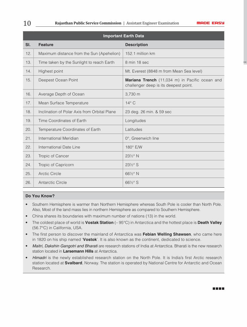
Important Earth Data
Sl. Feature Description
12. Maximum distance from the Sun (Apehelion) 152.1 million km
13. Time taken by the Sunlight to reach Earth 8 min 18 sec
14. Highest point Mt. Everest (8848 m from Mean Sea level)
15. Deepest Ocean Point Mariana Trench (11,034 m) in Pacific ocean and challenger deep is its deepest point.
16. Average Depth of Ocean 3,730 m
17. Mean Surface Temperature 14° C
18. Inclination of Polar Axis from Orbital Plane 23 deg. 26 min. & 59 sec
19. Time Coordinates of Earth Longitudes
20. Temperature Coordinates of Earth Latitudes
21. International Meridian 0°, Greenwich line
22. International Date Line 180° E/W
23. Tropic of Cancer 23½° N
24. Tropic of Capricorn 23½° S
25. Arctic Circle 66½° N
26. Antarctic Circle 66½° S
Do You Know?
• Southern Hemisphere is warmer than Northern Hemisphere whereas South Pole is cooler than North Pole. Also, Most of the land mass lies in northern Hemisphere as compared to Southern Hemisphere.
• China shares its boundaries with maximum number of nations (13) in the world.
• The coldest place of world is Vostak Station (– 95°C) in Antarctica and the hottest place is Death Valley (56.7°C) in California, USA.
• The first person to discover the mainland of Antarctica was Febian Welling Shawsen, who came here in 1820 on his ship named ‘Vostok’. It is also known as the continent, dedicated to science.
• Maitri, Dakshin Gangotri and Bharati are research stations of India at Antarctica. Bharati is the new research station located in Larsemann Hills at Antarctica.
• Himadri is the newly established research station on the North Pole. It is India’s first Arctic research station located at Svalbard, Norway. The station is operated by National Centre for Antarctic and Ocean Research.
Rajasthan Public Service Commission | Assistant Engineer Examination10