Geography 1st CSE
117
Social Science 1st CSE Geography Jorge Elías de la Peña y Montes de Oca Teacher at the Bilingual Section Department of Geography and History IES Complutense. Alcalá de Henares
-
Upload
vicente-perez-navarro -
Category
Documents
-
view
110 -
download
7
Transcript of Geography 1st CSE
IES COMPLUTENSE DEPARTMENT OF GEOGRAPHY AND HISTORY Jorge-Elías de la Peña y Montes de Oca
1st CSE YEAR UNIT 1. PREHISTORY
1 1 1
Social Science 1st CSE Geography
Jorge Elías de la Peña y Montes de Oca
Teacher at the Bilingual Section Department of Geography and History
IES Complutense. Alcalá de Henares

IES COMPLUTENSE DEPARTMENT OF GEOGRAPHY AND HISTORY Jorge-Elías de la Peña y Montes de Oca
1st CSE YEAR UNIT 6. THE UNIVERSE AND THE EARTH
2
Social Science 1st CSE
UNIT 6: The Universe and the Earth
IES COMPLUTENSE 1ST YEAR CSE
DEPARTMENT OF GEOGRAPHY AND HISTORY THE UNIVERSE AND THE EARTH
3
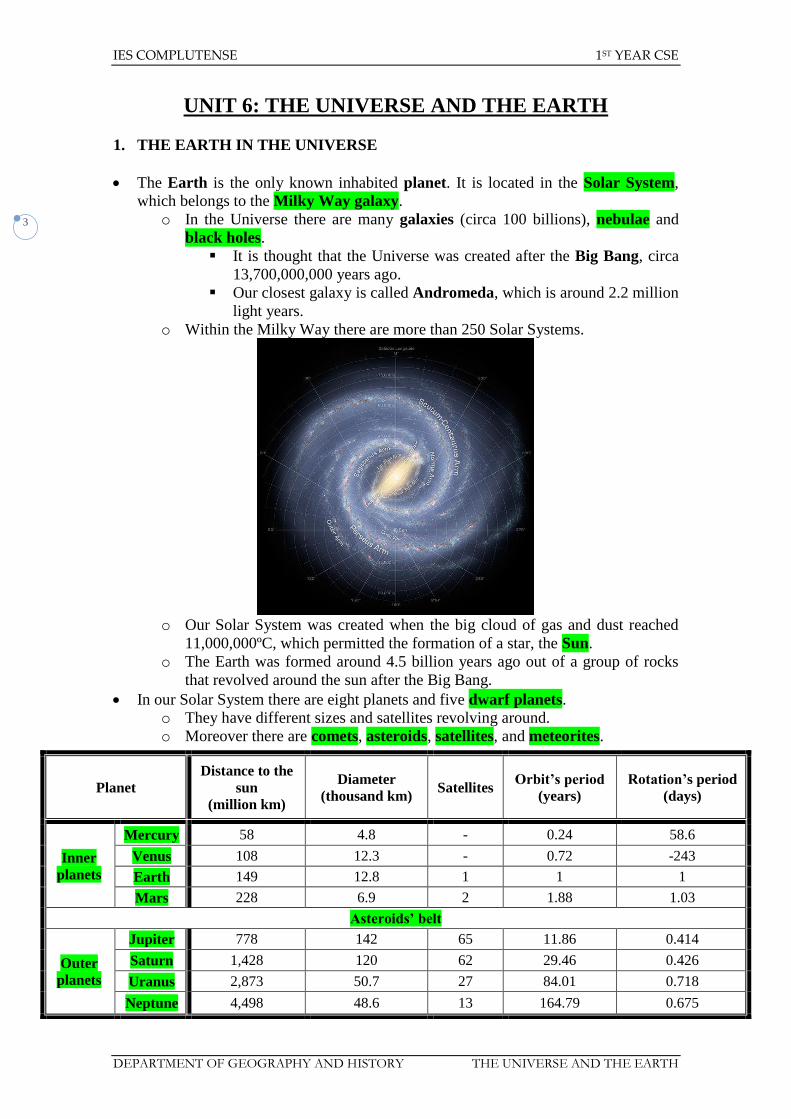
UNIT 6: THE UNIVERSE AND THE EARTH
1. THE EARTH IN THE UNIVERSE
The Earth is the only known inhabited planet. It is located in the Solar System,
which belongs to the Milky Way galaxy.
o In the Universe there are many galaxies (circa 100 billions), nebulae and
black holes.
It is thought that the Universe was created after the Big Bang, circa
13,700,000,000 years ago.
Our closest galaxy is called Andromeda, which is around 2.2 million
light years.
o Within the Milky Way there are more than 250 Solar Systems.
o Our Solar System was created when the big cloud of gas and dust reached
11,000,000ºC, which permitted the formation of a star, the Sun.
o The Earth was formed around 4.5 billion years ago out of a group of rocks
that revolved around the sun after the Big Bang.
In our Solar System there are eight planets and five dwarf planets.
o They have different sizes and satellites revolving around.
o Moreover there are comets, asteroids, satellites, and meteorites.
Planet
Distance to the
sun
(million km)
Diameter
(thousand km) Satellites
Orbit’s period
(years)
Rotation’s period
(days)
Inner
planets
Mercury 58 4.8 - 0.24 58.6
Venus 108 12.3 - 0.72 -243
Earth 149 12.8 1 1 1
Mars 228 6.9 2 1.88 1.03
Asteroids’ belt
Outer
planets
Jupiter 778 142 65 11.86 0.414
Saturn 1,428 120 62 29.46 0.426
Uranus 2,873 50.7 27 84.01 0.718
Neptune 4,498 48.6 13 164.79 0.675

IES COMPLUTENSE 1ST YEAR CSE
DEPARTMENT OF GEOGRAPHY AND HISTORY THE UNIVERSE AND THE EARTH
4
o All the planets of the Solar System revolve around an only star, the Sun,
whose diameter is around 1,391,000 kilometres.
o The orbits on which they revolve are elliptical.

IES COMPLUTENSE 1ST YEAR CSE
DEPARTMENT OF GEOGRAPHY AND HISTORY THE UNIVERSE AND THE EARTH
5
o The inner planets are mostly rocky and small, whereas the outer planets
are gaseous, big and they have many satellites revolving around them.
Dwarf
planet
Distance to the sun
(million km)
Diameter
(km) Satellites
Orbit’s
period
(years)
Rotation’s
period
(days)
Ceres 415.5 952.4 - 4.59 0.38
Pluto 5850 2,302 4 247.92 -6.39
Haumea 6501 ? 2 285.4 0.16
Makemake 6868 ? - 309.9 ?
Eris 10,200 2,398 1 557 ?

IES COMPLUTENSE 1ST YEAR CSE
DEPARTMENT OF GEOGRAPHY AND HISTORY THE UNIVERSE AND THE EARTH
6
The Earth’s only satellite is called the Moon:
o It is around 384,000 kilometres away from the Earth.
o It revolves around the Earth and takes 28¼ days to do it.
o The moon has four different phases that can be appreciated from the Earth:
New moon. The moon faces to the Earth its invisible side (not lit by
the sun).
Waxing crescent (First quarter).
Full moon. Its visible side is completely lit by the sun and can be
seen from the Earth.
Waning crescent (Third quarter).

IES COMPLUTENSE 1ST YEAR CSE
DEPARTMENT OF GEOGRAPHY AND HISTORY THE UNIVERSE AND THE EARTH
7
The Earth has a spherical shape, but its poles are slightly flattened and the equator is
a little widened. That is the reason why it is said that its shape is a geoid.
o The Earth has an axial tilt of 23º 27’ from the vertex, whose result is the
seasonal change in climate.
o Its surface is around 510 million square kilometres (the sun is circa
1,300,000 bigger than the Earth).
The 70% consists of water (oceans, seas, rivers, and lakes.
The 30% consists of land (continents and islands).
Life can exist on the Earth thanks to several factors:
o Mild temperature (around 15ºC average).
o There is liquid water on the surface.
o Our atmosphere contains the vital gases we need (21% oxygen, 78%
nitrogen and 1% of other gases).
It avoids excessive cooling and heating of the Earth.
It filters the harmful solar radiations (UVA Rays and X Rays).
2. THE REVOLUTION OF THE EARTH
The Earth has two kinds of movements:
o Earth’s orbit around the sun. Our planet moves at 30 km/sec following its
elliptical orbit around the sun, which takes 365¼ days (that explains the leap
years every four years, which have 366 days).
It fixes the duration of the day and the night according to the season.
It provokes the seasonal change due to the axial tilt.
Spring. In the southern hemisphere it is autumn.
Summer. In the southern hemisphere it is winter.
Autumn. In the southern hemisphere it is spring.
Winter. In the southern hemisphere it is summer.
IES COMPLUTENSE 1ST YEAR CSE
DEPARTMENT OF GEOGRAPHY AND HISTORY THE UNIVERSE AND THE EARTH
8
Climates are caused by this movement. There are three different kind
of climate zones in the world:
One warm zone (Torrid Zone). It is located around the
equator up to the tropics.
Two temperate zones. They are located between the tropics
and the polar circles.
Two cold zones (Frigid Zones). They are above the polar
circles.
o Rotation. The Earth spins on its own axis, which takes 24 hours:
It moves from west to east.
Day and night are caused by the rotation since the sun just lights half
of the Earth.
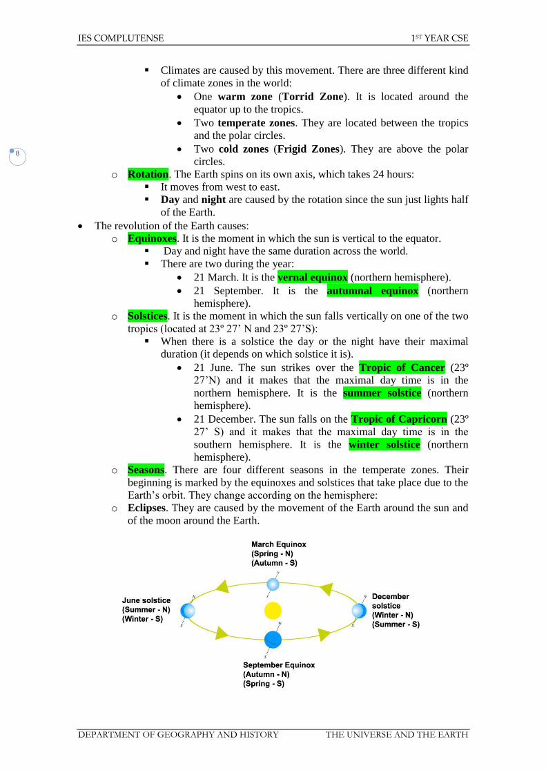
The revolution of the Earth causes:
o Equinoxes. It is the moment in which the sun is vertical to the equator.
Day and night have the same duration across the world.
There are two during the year:
21 March. It is the vernal equinox (northern hemisphere).
21 September. It is the autumnal equinox (northern
hemisphere).
o Solstices. It is the moment in which the sun falls vertically on one of the two
tropics (located at 23º 27’ N and 23º 27’S):
When there is a solstice the day or the night have their maximal
duration (it depends on which solstice it is).
21 June. The sun strikes over the Tropic of Cancer (23º
27’N) and it makes that the maximal day time is in the
northern hemisphere. It is the summer solstice (northern
hemisphere).
21 December. The sun falls on the Tropic of Capricorn (23º
27’ S) and it makes that the maximal day time is in the
southern hemisphere. It is the winter solstice (northern
hemisphere).
o Seasons. There are four different seasons in the temperate zones. Their
beginning is marked by the equinoxes and solstices that take place due to the
Earth’s orbit. They change according on the hemisphere:
o Eclipses. They are caused by the movement of the Earth around the sun and
of the moon around the Earth.
IES COMPLUTENSE 1ST YEAR CSE
DEPARTMENT OF GEOGRAPHY AND HISTORY THE UNIVERSE AND THE EARTH
9
3. PARTS OF THE EARTH
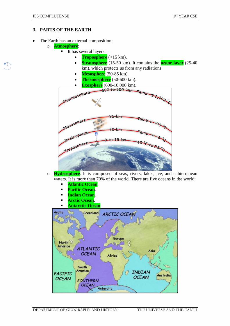
The Earth has an external composition:
o Atmosphere:
It has several layers:
Troposphere (<15 km).
Stratosphere (15-50 km). It contains the ozone layer (25-40
km), which protects us from any radiations.
Mesosphere (50-85 km).
Thermosphere (50-600 km).
Exosphere (600-10,000 km).
o Hydrosphere. It is composed of seas, rivers, lakes, ice, and subterranean
waters. It is more than 70% of the world. There are five oceans in the world:
Atlantic Ocean.
Pacific Ocean.
Indian Ocean.
Arctic Ocean.
Antarctic Ocean.
IES COMPLUTENSE 1ST YEAR CSE
DEPARTMENT OF GEOGRAPHY AND HISTORY THE UNIVERSE AND THE EARTH
10
o Lithosphere. It is composed of continents and the seabed. There are six
continents in the world:
Asia.
America.
Africa.
Europe.
Oceania.
Antarctica.
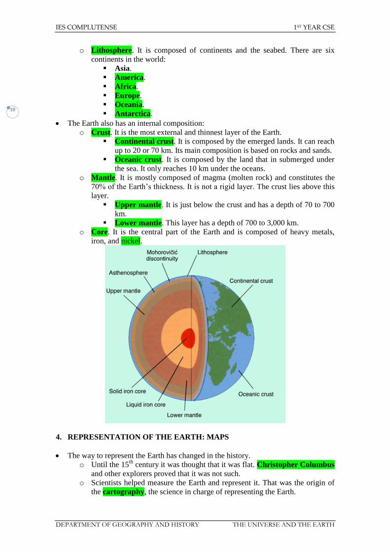
The Earth also has an internal composition:
o Crust. It is the most external and thinnest layer of the Earth.
Continental crust. It is composed by the emerged lands. It can reach
up to 20 or 70 km. Its main composition is based on rocks and sands.
Oceanic crust. It is composed by the land that in submerged under
the sea. It only reaches 10 km under the oceans.
o Mantle. It is mostly composed of magma (molten rock) and constitutes the
70% of the Earth’s thickness. It is not a rigid layer. The crust lies above this
layer.
Upper mantle. It is just below the crust and has a depth of 70 to 700
km.
Lower mantle. This layer has a depth of 700 to 3,000 km.
o Core. It is the central part of the Earth and is composed of heavy metals,
iron, and nickel.
4. REPRESENTATION OF THE EARTH: MAPS
The way to represent the Earth has changed in the history.
o Until the 15th
century it was thought that it was flat. Christopher Columbus
and other explorers proved that it was not such.
o Scientists helped measure the Earth and represent it. That was the origin of
the cartography, the science in charge of representing the Earth.
IES COMPLUTENSE 1ST YEAR CSE
DEPARTMENT OF GEOGRAPHY AND HISTORY THE UNIVERSE AND THE EARTH
11
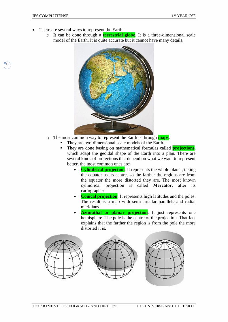
There are several ways to represent the Earth:
o It can be done through a terrestrial globe. It is a three-dimensional scale
model of the Earth. It is quite accurate but it cannot have many details.
o The most common way to represent the Earth is through maps:
They are two-dimensional scale models of the Earth.
They are done basing on mathematical formulas called projections,
which adapt the geoidal shape of the Earth into a plan. There are
several kinds of projections that depend on what we want to represent
better, the most common ones are:
Cylindrical projection. It represents the whole planet, taking
the equator as its centre, so the farther the regions are from
the equator the more distorted they are. The most known
cylindrical projection is called Mercator, after its
cartographer.
Conical projection. It represents high latitudes and the poles.
The result is a map with semi-circular parallels and radial
meridians.
Azimuthal or planar projection. It just represents one
hemisphere. The pole is the centre of the projection. That fact
explains that the farther the region is from the pole the more
distorted it is.

IES COMPLUTENSE 1ST YEAR CSE
DEPARTMENT OF GEOGRAPHY AND HISTORY THE UNIVERSE AND THE EARTH
12
There are several kinds of maps:
Topographic maps. They show the relief or physical
characteristics of the planet. It also shows the altitude of the
region through the contour lines.
Thematic maps. They can have different subjects:
o Physical maps.
o Political maps.
o Population maps.
o Vegetation maps.
o Climate maps...

IES COMPLUTENSE 1ST YEAR CSE
DEPARTMENT OF GEOGRAPHY AND HISTORY THE UNIVERSE AND THE EARTH
13
Maps are now done through photographs, normally taken from
satellites. There are also modern techniques such as GIS (Geographic
Information System) or remote sensing.
https://docs.google.com/open?id=0Bwe1dU-54DkeZ1QtaFFROHdXS2c
https://docs.google.com/open?id=0Bwe1dU-54Dkec3ZUbVg3UGVTZ0k
There are several major elements on a map or on a terrestrial globe:
o Cardinal Points. They help the orientation and can be known thanks to
nature or to other artificial means, such as the compass:
North.
South.
East.
West.
o Coordinates. They help find an exact point on a map through imaginary
lines. The units taken for that measure are degrees (º), minutes (’), and
seconds (’’).

IES COMPLUTENSE 1ST YEAR CSE
DEPARTMENT OF GEOGRAPHY AND HISTORY THE UNIVERSE AND THE EARTH
14
Meridians. They are the imaginary lines that link the poles (they go
from the north to the south or vice versa). They fix the longitude,
which can be either east or west. All the meridians measure the same
and there are 360 (up to 180ºE and 180ºW).
In 1884 it was agreed to fix the location of the Prime
Meridian (0º) in Greenwich, hence its name. It has its
antipodes at 180º.
Meridians fix the time zones, which are 24 in total basing on
the location of each region and the sun (each time zone
stretches 15º). The time we use as a reference is called
Greenwich Mean Time (GMT). As we move eastwards,
clocks move forward the same number of hours as time zones
travelled. On the contrary, if we move westwards, clocks go
back the same number of hours as time zones travelled.
Parallels. They are imaginary lines that are parallel to the equator
(parallel 0º). There are 180 in total (90ºN and 90ºS). They fix the
latitude (north or south) and divide the world into two parts, the
northern and the southern hemispheres. There are several major
parallels.
Equator. It is located at 0º and it separates the northern and
the southern hemispheres.

IES COMPLUTENSE 1ST YEAR CSE
DEPARTMENT OF GEOGRAPHY AND HISTORY THE UNIVERSE AND THE EARTH
15
Tropics. They are the imaginary lines that are the maximal
point of perpendicular fall of the sun onto the Earth. They are
caused due to the axial tilt.
o Tropic of Cancer. It is located at 23º27’N.
o Tropic of Capricorn. It is located at 23º27’S.
Polar Circles. They are the imaginary lines above which
there is at least 24 hours of day-time or night-time in a row.
They are also caused by the axial tilt.
o Arctic Circle. It is located at 66º33’N
o Antarctic Circle. It is located at 66º33’S.
o Scale. It is the ratio of a distance on the map to the corresponding distance
on the ground.
It helps get the real distances.
It can be represented in two ways:
Numerical scale. It is a ratio or a fraction from which we can
get the distance (1:x, 1/x, 1 to x). It means that one centimetre
on the map is actually x.
Bar, linear or graphic scale. It is a line marked at intervals
to show the distance on the earth or object which the distance
on the scale represents.
Maps change their scale according to what it has been represented,
the larger the scale is the more detail there is on the map (so the
represented region is smaller):
Small scale. It has very few details and represents large areas,
it is above 1:100,000.
Medium scale. It represents smaller areas and its scale
stretches from 1:50,000 to 1:100,000.
Large scale. It is the most detailed map that shows smaller
regions. The scale is smaller than 1:50,000.
IES COMPLUTENSE 1ST YEAR CSE
DEPARTMENT OF GEOGRAPHY AND HISTORY THE UNIVERSE AND THE EARTH
16
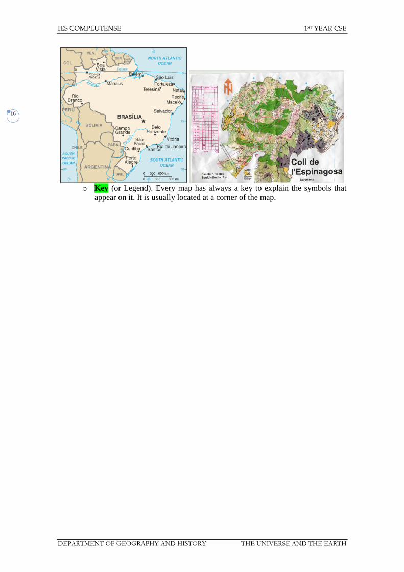
o Key (or Legend). Every map has always a key to explain the symbols that
appear on it. It is usually located at a corner of the map.

IES COMPLUTENSE 1ST YEAR CSE
DEPARTMENT OF GEOGRAPHY AND HISTORY THE UNIVERSE AND THE EARTH
17
Unit 6. The Universe and the Earth
Exercises
1. What is the Milky Way?
2. How many planets are there in our Solar System? How many dwarf planets are
there?
3. Match the words to the correct groups:
Pluto
Milky Way
Sun stars
Saturn galaxies
Earth planets
Jupiter dwarf planets
Ceres
Mars
4. Answer true or false and correct the wrong sentences:
a. There are three dwarf planets.
b. The eight planets are divided into three groups.
c. The smallest planet is Venus.
5. Which planet is nearest to the Sun? Which is the furthest from the Sun? What is
the Earth’s position?
6. Which planet is nearest to the Earth? Which is the farthest planet from the
Earth?
7. Which is the largest planet of the Solar System? And the smallest one?
8. Complete the sentences and choose the correct words:
a. The Earth in a(n) perfect/imperfect___________ sphere.
b. The Equator divides the Earth into two equal poles/
hemispheres_____________.
c. One reason there is life on Earth is because there is liquid
water/gas___________.
d. The temperature/atmosphere_______________ protects us from harmful
radiation.
9. Complete the sentences with the next figures:
40,009 510,000,000 1,000 2 40,077
a. The equator is _____________ km long.
b. The Earth is made up of ____________ hemispheres.
c. At ______________ km2, the total surface of the Earth is ________
times bigger than Spain.
d. A meridian is _______________ km long.
10. Why does the Earth look blue when seen from space?
11. In which hemisphere are most of the Earth’s continents?

IES COMPLUTENSE 1ST YEAR CSE
DEPARTMENT OF GEOGRAPHY AND HISTORY THE UNIVERSE AND THE EARTH
18
12. Complete the chart with the main characteristics of the two movements made by
the Earth.
Rotation Revolution
Duration
Direction of movement
What it consists of
Consequences
13. Look at the picture and answer the following questions:
a. How many cardinal points are there?
b. How can we explain the apparent movement of the Sun?
c. At what cardinal point does the sun rise?
14. Match each date with the correct information:
23 September Autumn equinox in the northern
hemisphere and spring equinox in
the southern hemisphere
21-22 December Spring equinox in the northern
hemisphere and autumn equinox in
the southern hemisphere
20-21 June Winter solstice in the northern
hemisphere and summer solstice in
the southern hemisphere
21 March Summer solstice in the northern
hemisphere and winter solstice in
the southern hemisphere
15. What season is it when both hemispheres receive the same amount of light?
16. What season is it in the north when the North Pole is tilted towards the Sun?
17. Complete the sentences:
a. The Earth consists of ________ large sections: the core, the _________,
and the crust.
b. The mantle is ____________% of the Earth’s total volume.
c. The Earth’s ___________ is between 10 and ______ kilometres thick.

IES COMPLUTENSE 1ST YEAR CSE
DEPARTMENT OF GEOGRAPHY AND HISTORY THE UNIVERSE AND THE EARTH
19
d. _____________ is the highest point in the world at _______ metres.
18. Are the following sentences true or false? Correct the wrong ones.
a. The core is the Earth’s outer layer.
b. The mantle consists only of solid rock.
c. The continents are on the crust of the Earth.
d. The Earth rotates towards the west.
19. Make a drawing of the layers of the atmosphere.
20. Which atmospheric layer is being described?
a. Meteorological phenomena happen here.
b. It is where the ozone layer is located.
c. Temperatures are very high in this layer.
d. Most of the air we breathe is located in this layer.
21. How can the atmosphere protect the Earth?
22. Draw a map of the Earth and add the main parallels (Equator, Tropic of Cancer,
Tropic of Capricorn, Arctic Circle, Antarctic Circle), the prime meridian, South
Pole and North Pole.
23. In an atlas locate your town or city and write down what parallel and meridian it
is on.
24. Match each word to one of the two concepts below:
North
Greenwich
Tropic of Cancer
Longitude parallels
Latitude meridians
West
Arctic Circle
Time zones
25. What do the lines represent in this diagram of the world?
a.
b.
c.
d.
e.
f.

IES COMPLUTENSE 1ST YEAR CSE
DEPARTMENT OF GEOGRAPHY AND HISTORY THE UNIVERSE AND THE EARTH
20
26. In an atlas, find the geographic coordinates (latitude and longitude) of the
following cities.
a. Tokyo.
b. New York.
c. Moscow.
d. Johannesburg.
e. Madrid.
f. Montevideo.
g. Sydney.
27. In an atlas find five countries that the Equator runs through and five that the
Greenwich meridian goes through.
28. Is there any place in the world at latitude 110ºN or 110ºS. If yes, say where it is.
If not, explain why.
29. Only one of these names of parallels and meridians is correct. Write the others
correctly.
a. Tropic of Equator.
b. Circle of Cancer.
c. Arctic Circle.
d. Meridian of Capricorn.
e. Tropic of Greenwich.
30. With the help of an atlas, answer this question. What time is it in the following
cities if in Greenwich it is 4 p.m.?
a. Warsaw.
b. Baghdad.
c. Wellington.
d. Lima.
e. Las Palmas de Gran Canaria.
31. How many time zones are there in the world? How wide is each time zone?
32. Do all places in Spain share the same time?
33. Why is it necessary to use cartographic projections to depict the Earth?
34. What type of projection is depicted on the map?
35. What part of the world will be more distorted if we use a cylindrical projection?
And if we use a conical projection?
36. Order the letters to make words from the unit:
a. Mdianeri
b. Lallraep
c. Ltdeitua
d. Itngudelo
e. Uareqto
f. Tpirocs
g. Cphyrtogra
h. Tatiroon

IES COMPLUTENSE 1ST YEAR CSE
DEPARTMENT OF GEOGRAPHY AND HISTORY THE UNIVERSE AND THE EARTH
21
37. Match four of the words from the previous activity to the definitions below:
a. An imaginary circle that divides the Earth into two equal halves.
b. The practice of drawing maps.
c. The distance between any point of the Earth’s surface and the 0º
meridian.
d. The 24-hour movement of the Earth.
38. Draw the position of the Earth, the Sun and the Moon during a solar eclipse.
39. Answer the following questions:
a. What is a map?
b. What are maps used for?
c. How did maps emerge in the past?
40. Which is the best projection to represent...?
a. The poles.
b. The areas in middle latitudes.
c. The world.
41. Find the following cities on the map:
a. Porto Novo (32ºS, 52ºW).
b. Cracow (50ºN, 20ºE).
c. Castellón de la Plana (40ºN, 0ºE).
d. Singapore (0ºN, 104ºE).
e. Miami (30ºN, 80ºW).
42. To represent the continent of Africa, would you use a small- or large-scale map?
Explain your answer.
43. What are the two forms of representing scale on maps.
44. Correct the following sentence: A large-scale map represents a large geographic
area while a small-scale map represents a small geographic area.
45. Look at the map of Spain below and basing on the scale find out the real
distance between Seville and Barcelona. Which is the numerical scale used in
the map?

IES COMPLUTENSE 1ST YEAR CSE
DEPARTMENT OF GEOGRAPHY AND HISTORY THE UNIVERSE AND THE EARTH
22
46. On a map with a scale 1:400,000, two points are 5 cm apart. How may km
separate them in reality? How many km would be equivalent to 7 cm on that
same map?
47. True or false. Correct the false ones:
a. There are 15 time zones of 24º each.
b. In a cylindrical projection, the Earth is inscribed on a cylinder.
c. It is the same time in all countries of the world.
d. Aerial photography obtains images from artificial satellites.
e. Numerical scale is expressed by fraction in which the numerator
represents the unit on the map and the denominator expresses the real
size.
f. On large-scale maps, very large areas of the Earth are represented with
very little detail.
48. Match each term with its definition:
Rotation Longitude Meridian Latitude
a. The distance, measured in degrees, from any point on Earth to the
Greenwich meridian.
b. The movement of the Earth around its axis.
c. The distance, measured in degrees, from any point on Earth to the
equator.
d. The imaginary line that goes from the North Pole to the South Pole.
49. Complete the chart with the missing noun or verb.
Verb Noun
Rotate
Projection
Revolve
Representation
Locate
Reduction

IES COMPLUTENSE 1ST YEAR CSE
DEPARTMENT OF GEOGRAPHY AND HISTORY THE UNIVERSE AND THE EARTH
23
50. Complete the sentences with a noun or verb from the previous exercise:
a. The Earth ___________ on its axis.
b. A map is the _____________ on a plane of part of the Earth’s surface.
c. To represents the Earth on a map, we use _______________.
d. The cardinal points help us to ______________ specific places on the
Earth.
IES COMPLUTENSE DEPARTMENT OF GEOGRAPHY AND HISTORY Jorge-Elías de la Peña y Montes de Oca
1st CSE YEAR UNIT 7. RELIEF AND WATER
1
Social Science 1st CSE
UNIT 7: Relief and water

IES COMPLUTENSE DEPARTMENT OF GEOGRAPHY AND HISTORY Jorge-Elías de la Peña y Montes de Oca
1st CSE YEAR UNIT 7. RELIEF AND WATER
2
UNIT 7: RELIEF AND WATER
1. EARTH’S RELIEF
Despite the name, the Earth is mostly covered by water:
o Hydrosphere is around 71% of the surface.
o Only 29% are emerged lands.
The continental relief has several formations:
o Mountains. They are elevations of the land with different origin.
They were created during the orogenies some millions years ago.
The highest mountains emerged in more recent periods. Their
profiles are steeper. They usually form mountain ranges:
The highest mountain range are the Himalayas (Everest is the
highest mountain in the world, 8,848 m).
The longest mountain range is the Andes (together with
Sierra Madre and the Rocky Mountains).
The oldest mountains are lower and rounder. They are called
massifs. They used to be high but they were eroded.
o Plateaux. They are large flat high areas higher than 400 metres. The highest
ones in the world are the Tibetan Plateau and the Altiplano (Bolivia), they
exceed 3,000 metres high. Most of Spain is composed by the Iberian
Plateau.
o Plains. They are flat and low-lying lands that do not exceed 200 metres high.
They are usually along the coast (coastal plains) or by the rivers (river
plains).
o Valleys. They have been created by the rivers in their flow towards their
mouth. They are usually low lands between mountains.
o Depressions. They are large areas located below sea level, such as the Dead
Sea (-395 m), Death Valley (-86 m) or the Caspian Sea (-28 m).
The coastal relief is composed of several types:
o Beaches. They are geological landforms along the shoreline of an ocean, sea,
lake or river. It usually consists of loose particles which are often composed
of rock, such as sand, gravel, shingle, pebbles or cobblestones.

IES COMPLUTENSE DEPARTMENT OF GEOGRAPHY AND HISTORY Jorge-Elías de la Peña y Montes de Oca
1st CSE YEAR UNIT 7. RELIEF AND WATER
3
o Rias. Coastal inlets formed by the partial submergence of a non-glaciated
river valley.
o Fiords. Coastal inlets formed by the partial submergence of a glaciated
valley.
o Cliffs. They are a significant vertical, or near vertical, rock exposure.
o Coastal lagoons. Saltwater lagoons separated from the sea by narrow sand
strips.
o Marshlands. They are a type of wetland that is subject to frequent or
continuous flood.
o Bays and gulfs. They are areas of water mostly surrounded by land.
o Capes. They are points or bodies of land extending into a body of water,
usually the sea.
o Peninsulas. Piece of land that is bordered by water on three sides but
connected to mainland through an isthmus.
o Isthmus. They connect peninsulas to a continent.
o Islands. Area of land completely surrounded by water. If there is a group of
islands it is called archipelago.
The submarine relief has also several kinds of formations:
o Continental shelf. They are vast coastal plateaux that are not deeper than
200 metres. Their width is around 100-500 km. Most of the fishing grounds
are in this part of the ocean.
o Continental slope. It is a steep step that descends from the continental shelf
to the ocean basin.
o Ocean basin or abyssal plain. It is a major deep plain that is around 3,000-
5,000 metres deep. There can be two other formations within the ocean
basin:
Oceanic trenches, which are narrow but deep depressions of sea
floor (the deepest one is the Mariana Trench, 11,022 m).
Submarine ridge. They are submerged mountain ranges that are
around 3,000 metres higher than the abyssal plain. They are usually
the boundary of the tectonic plates. Therefore magma comes out
from the summit of these ranges. There can be volcanic islands on
their highest points (Iceland, Azores).

IES COMPLUTENSE DEPARTMENT OF GEOGRAPHY AND HISTORY Jorge-Elías de la Peña y Montes de Oca
1st CSE YEAR UNIT 7. RELIEF AND WATER
4
2. RELIEF FORMATION
The Earth is constantly changing. The formations of the Earth are not permanent.
The German scientist Alfred Wegener proposed in 1912 the Theory of the
continental drift which hypothesised that the continents were slowly drifting
around the Earth. Basing on his theory the evolution of the continents was as
follows:
o 300,000,000 years ago only Pangaea existed. It was an only continent
completely surrounded by the Thetys Sea.
o 180,000,000 years ago that only continent split into two supercontinents:
Laurasia. It was composed of North America and Eurasia.
Gondwana. It was composed of South America, Africa, Antarctica,
Australia, and India.
o 150,000,000 years ago Gondwana split into several continents:
A block was composed of Antarctica, India, and Australia.
The other block was composed of South America and Africa.
o 135,000,000 years ago there were several modifications in the continents:
Laurasia split into two other continents and the North Atlantic Ocean
was created:
North America.
Eurasia.
Australia and India split up from Antarctica and moved northwards.
o 30,000,000 years ago there was a major change that made the world similar
to ours:
IES COMPLUTENSE DEPARTMENT OF GEOGRAPHY AND HISTORY Jorge-Elías de la Peña y Montes de Oca
1st CSE YEAR UNIT 7. RELIEF AND WATER
5
Both two Americas joined and the Isthmus of Panama was created.
India crashed on Asia, which created the Himalayas.
Africa moved northwards and the Mediterranean Sea was created.
Australia moved northwards.
o Nowadays the Earth is still changing and there are some movements:
America is moving away from Europe. The North Atlantic Ocean is
thus wider.
Africa is getting closer to Eurasia which involves the reduction of the
Mediterranean Sea.
India is setting into Asia, which makes the Himalayas much higher.
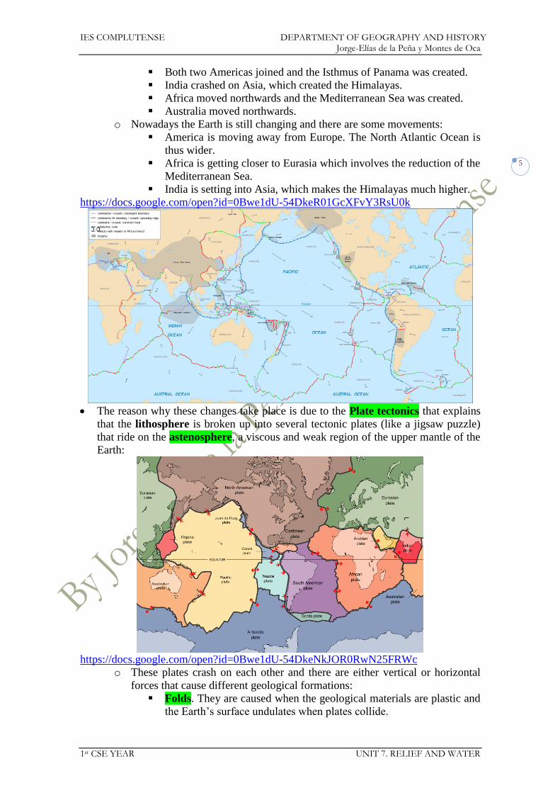
https://docs.google.com/open?id=0Bwe1dU-54DkeR01GcXFvY3RsU0k
The reason why these changes take place is due to the Plate tectonics that explains
that the lithosphere is broken up into several tectonic plates (like a jigsaw puzzle)
that ride on the astenosphere, a viscous and weak region of the upper mantle of the
Earth:
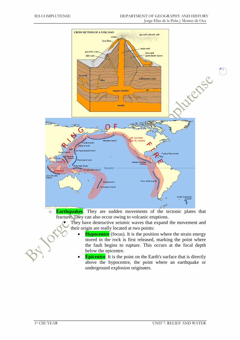
https://docs.google.com/open?id=0Bwe1dU-54DkeNkJOR0RwN25FRWc
o These plates crash on each other and there are either vertical or horizontal
forces that cause different geological formations:
Folds. They are caused when the geological materials are plastic and
the Earth’s surface undulates when plates collide.

IES COMPLUTENSE DEPARTMENT OF GEOGRAPHY AND HISTORY Jorge-Elías de la Peña y Montes de Oca
1st CSE YEAR UNIT 7. RELIEF AND WATER
6
Faults. They are caused when the geological materials are rigid and
they crack when plates collide.
o Mountains are created by this process called orogeny or orogenesis.
There are some internal agents that modify relief:
o Volcanoes. They are openings that expel magma through the vent and
crater. They are usually located at the plate boundaries. They usually expel
lava, ashes, and gases. There are three categories of volcanoes:
Active volcanoes. They have frequent eruptions.
Dormant volcanoes. They are volcanoes which are recharging their
lava supply. Meanwhile they repose.
Extinct volcanoes. They are unlikely to erupt again because they
have no lava supply.
IES COMPLUTENSE DEPARTMENT OF GEOGRAPHY AND HISTORY Jorge-Elías de la Peña y Montes de Oca
1st CSE YEAR UNIT 7. RELIEF AND WATER
7
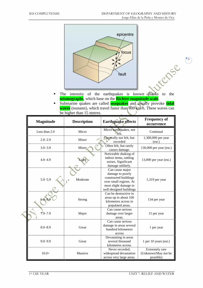
o Earthquakes. They are sudden movements of the tectonic plates that
fracture. They can also occur owing to volcanic eruptions.
They have destructive seismic waves that expand the movement and
their origin are really located at two points:
Hypocentre (focus). It is the position where the strain energy
stored in the rock is first released, marking the point where
the fault begins to rupture. This occurs at the focal depth
below the epicentre.
Epicentre. It is the point on the Earth's surface that is directly
above the hypocentre, the point where an earthquake or
underground explosion originates.
IES COMPLUTENSE DEPARTMENT OF GEOGRAPHY AND HISTORY Jorge-Elías de la Peña y Montes de Oca
1st CSE YEAR UNIT 7. RELIEF AND WATER
8
The intensity of the earthquakes is known thanks to the
seismographs, which base on the Richter magnitude scale.
Submarine quakes are called seaquakes and usually provoke tidal
waves (tsunami), which travel faster than 800 km/h. These waves can
be higher than 15 metres.
Magnitude Description Earthquake effects Frequency of
occurrence
Less than 2.0 Micro Micro earthquakes, not
felt. Continual
2.0–2.9 Minor Generally not felt, but
recorded
1,300,000 per year
(est.)
3.0–3.9 Minor Often felt, but rarely
causes damage. 130,000 per year (est.)
4.0–4.9 Light
Noticeable shaking of
indoor items, rattling
noises. Significant
damage unlikely.
13,000 per year (est.)
5.0–5.9 Moderate
Can cause major
damage to poorly
constructed buildings
over small regions. At
most slight damage to
well-designed buildings
1,319 per year
6.0–6.9 Strong
Can be destructive in
areas up to about 160
kilometres across in
populated areas.
134 per year
7.0–7.9 Major
Can cause serious
damage over larger
areas.
15 per year
8.0–8.9 Great
Can cause serious
damage in areas several
hundred kilometres
across
1 per year
9.0–9.9 Great
Devastating in areas
several thousand
kilometres across.
1 per 10 years (est.)
10.0+ Massive
Never recorded,
widespread devastation
across very large areas.
Extremely rare
(Unknown/May not be
possible)

IES COMPLUTENSE DEPARTMENT OF GEOGRAPHY AND HISTORY Jorge-Elías de la Peña y Montes de Oca
1st CSE YEAR UNIT 7. RELIEF AND WATER
9
3. RELIEF EXTERNAL AGENTS
There are three different external agents that modify relief:
o Erosion. Rocks wear away and they dissolve.
o Carriage. It carries all the eroded materials from the rocks.
o Sedimentation. It deposits all the eroded and carried materials.
Erosion is caused due to several factors:
o Temperatures. Abrupt temperature changes cause the erosion of the rocks
such as the solifluction together with water since it infiltrates through rocks
and when it freezes, it expands and the rocks break.
o Water. It is a constant action over the rocks. It can be stronger depending on
the kind of stone (limestone can be eroded more easily).
Rain. It can create valleys and ravines.
Rivers. They have different parts where the erosion changes. It is
harder in the upper course due to the slope and the speed of waters.
Instead it is very scarce is the lower course, since the speed of the
flow is much smaller.
Sea. Waves and currents cause different coastal geological
formations such as cliffs or beaches.
Groundwater. It can cause caves and underground rivers.
o Wind. It wears away the rocks and detaches some particles that attack other
rocks, polish and model them. It is called aeolian or wind erosion. Dunes
are the most typical formations created by aeolian erosion.
o Vegetation. Most of the times, plants help fix soil but their roots can also
split rocks.
o Human beings. We transform environment for agriculture, stockbreeding,
cities, felling, reservoirs, fires, mining...
4. WORLD’S RELIEF
The Earth has six continents:
o Asia. It is the largest continent in the world with 44,000,000 sq km.
It is separated from Europe by the Ural Mountains and the Caspian
Sea.
It is bathed by the Pacific, Indian, and Arctic Oceans.
It is mostly located in the northern hemisphere.
o America. It is the second largest continent with 42,000,000 sq km.
It is divided into two major sections united by the Isthmus of
Panama:
North America. It is composed by the largest part of the
continent and stretches from the Arctic Ocean to the Isthmus
of Panama.
South America. It is smaller than North America and
stretches from the Isthmus of Panama to the Antarctic Ocean.
It is a very long continent that is bathed by the Arctic, Atlantic,
Antarctic, and Pacific Oceans.
o Africa. It has 30,000,000 sq km. It is quite symmetrical in both two
hemispheres.
It is separated from Europe by the Strait of Gibraltar and from Asia
by the Red Sea.

IES COMPLUTENSE DEPARTMENT OF GEOGRAPHY AND HISTORY Jorge-Elías de la Peña y Montes de Oca
1st CSE YEAR UNIT 7. RELIEF AND WATER
10
It is bathed by the Atlantic and the Indian Ocean.
o Europe. It is actually a peninsula of Asia and has just 10,500,000 sq km.
The Ural Mountains separate Europe from Asia.
It is just bathed by the Atlantic and Arctic Oceans.
Its coastal relief is quite broken with many seas and peninsulas.
o Oceania. It is the smallest continent of the world, only 9,000,000 sq km.
It is composed of many islands, out of which Australia is the largest
one (7,500,000 sq km).
Some other major islands are New Zealand and New Guinea.
It is mostly located in the Pacific Ocean, although it has some coasts
by the Indian Ocean.
o Antarctica. It has 13,800,000 sq km and is located around the South Pole.
It is quite unknown since it has never been inhabited (but scientists in
modern times).
Its average altitude is the highest in the world (2,000 metres).
It is completely bathed by the Antarctic Ocean.
5. WATERS
Most of the Earth is covered by water (71%), which is essential for life.
Water is continuously moving on or below the surface of the Earth. That is the
water cycle:
o Water in the seas evaporates and the liquid turns into vapour.
o Water vapour rises, cools and condensates creating clouds
o Wind moves the clouds.
o Condensed vapour falls as precipitation (rain, snow or hail).
o Some water infiltrates into the ground.
o Groundwater goes into the sea.
o River water goes into the sea and other rivers.
Only 3% is fresh water:
o Only 0.014% can be consumed, since the rest is glacial ice (Arctic and
Antarctic).

IES COMPLUTENSE DEPARTMENT OF GEOGRAPHY AND HISTORY Jorge-Elías de la Peña y Montes de Oca
1st CSE YEAR UNIT 7. RELIEF AND WATER
11
o Most of the water has been regulated by engineering, such as canals,
reservoirs, dikes, dams for hydroelectric power stations...
o Fresh water has been polluted due to population growth.
A river is a natural watercourse, usually freshwater, flowing towards an ocean, a
lake, a sea, or another river.
o They get its water through rain or thaw.
o The river that flows into another river is called tributary.
o There can be permanent rivers or seasonal rivers (called wadis).
o When a river is analysed it is important to know:
Source. Many rivers start from groundwater which rises and form
springs, whereas some others originate from glaciers or lakes. It will
explain the flow and some other characteristics of the river.
Basin. It is an extent or an area of land where surface water
converges to a single point, where the waters join another river or
sea. The larger it is the more flow the river will have.
Length. It measures the kilometres of the river. The longest ones in
the world are the rivers Amazon (6,800 km) and Nile (6,756 km).
Flow or volume. It measures how much water flows in the river. The
more it rains the larger the flow will be. The river with a largest flow
is the Amazon (average flow: 225,000 m3/sec).
River regime. It depends on what kind of water is supplied to the
river:
Melting regime. The flow of the river just comes out of
snow. The flow will be larger in spring due to the thaw.
Rainfall regime. The flow of the river just comes out of rain,
so the flow will be larger in the rainy season.
o They have different areas where the erosion and sedimentation varies:
Upper course. Erosion is hard due to the fast water flow and to the
slope.
Middle course. The river flows slower and there is less erosion. It is
the part where the eroded materials are carried. It is common that the
river makes meanders owing to the slow speed of the flow.
Lower course. Most of the materials are deposited and the soil is
filled with this alluvial materials.
o Rivers can have three different kinds of mouths:
Estuary. The mouth opens to the sea and is caused by strong tides.
Fresh water mixes with saltwater from the sea. Major examples are
the estuaries of River Plate, Tagus or Thames.

IES COMPLUTENSE DEPARTMENT OF GEOGRAPHY AND HISTORY Jorge-Elías de la Peña y Montes de Oca
1st CSE YEAR UNIT 7. RELIEF AND WATER
12
Delta. They are accumulation of materials deposited by the river in a
shallow part of the coast where it meets the sea. It is usually
triangular-shaped. Major examples are the deltas of the Nile,
Amazon, Ganges or Ebro.
Ria. Coastal inlet formed by the partial submergence of a non-
glaciated river valley. Major examples can be found on the coast of
Galicia.
IES COMPLUTENSE DEPARTMENT OF GEOGRAPHY AND HISTORY Jorge-Elías de la Peña y Montes de Oca
1st CSE YEAR UNIT 7. RELIEF AND WATER
13
A lake is a body of relatively still fresh or salt water of considerable size, localised
in a basin, which is surrounded by land.
o Their surface may vary. The largest one is the Caspian Sea (371,000 sq km)
and the deepest one is Lake Baikal (1,638 m).
o Water can be supplied by rivers, glaciers, and aquifers.
Groundwater runs and is stored under the ground. It is 25% of the water on the
continents.
o Most of groundwater comes from precipitation and infiltration.
o It is stored in aquifers and underground rivers and lakes.
o It can find a way to the surface, a spring.
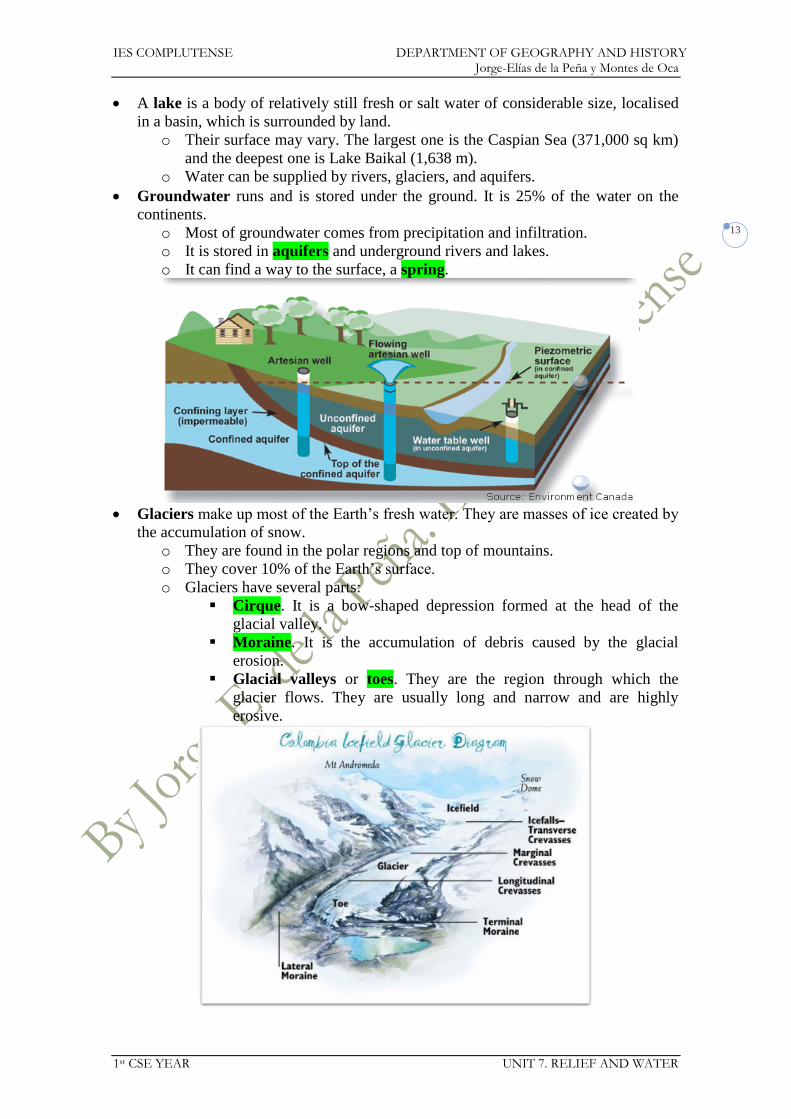
Glaciers make up most of the Earth’s fresh water. They are masses of ice created by
the accumulation of snow.
o They are found in the polar regions and top of mountains.
o They cover 10% of the Earth’s surface.
o Glaciers have several parts:
Cirque. It is a bow-shaped depression formed at the head of the
glacial valley.
Moraine. It is the accumulation of debris caused by the glacial
erosion.
Glacial valleys or toes. They are the region through which the
glacier flows. They are usually long and narrow and are highly
erosive.

IES COMPLUTENSE DEPARTMENT OF GEOGRAPHY AND HISTORY Jorge-Elías de la Peña y Montes de Oca
1st CSE YEAR UNIT 7. RELIEF AND WATER
14
Sea water is 97% of the Earth’s waters.
o It is salty due to the salt dissolution.
o It is saltier in hotter and seas surrounded by land (i.e. Dead Sea) where there
is more evaporation.
o Seas move constantly:
Waves. They are caused by the wind and are undulations of the
surface of the water. Their shape changes when they come into
contact with the sea floor.
Tides. They are the rise and fall of sea levels caused by the combined
effects of the gravitational forces exerted by the moon and the sun
and the rotation of the Earth:
High tide. It is the maximal level of the tide.
Low tide. It is the minimal level of the tide.
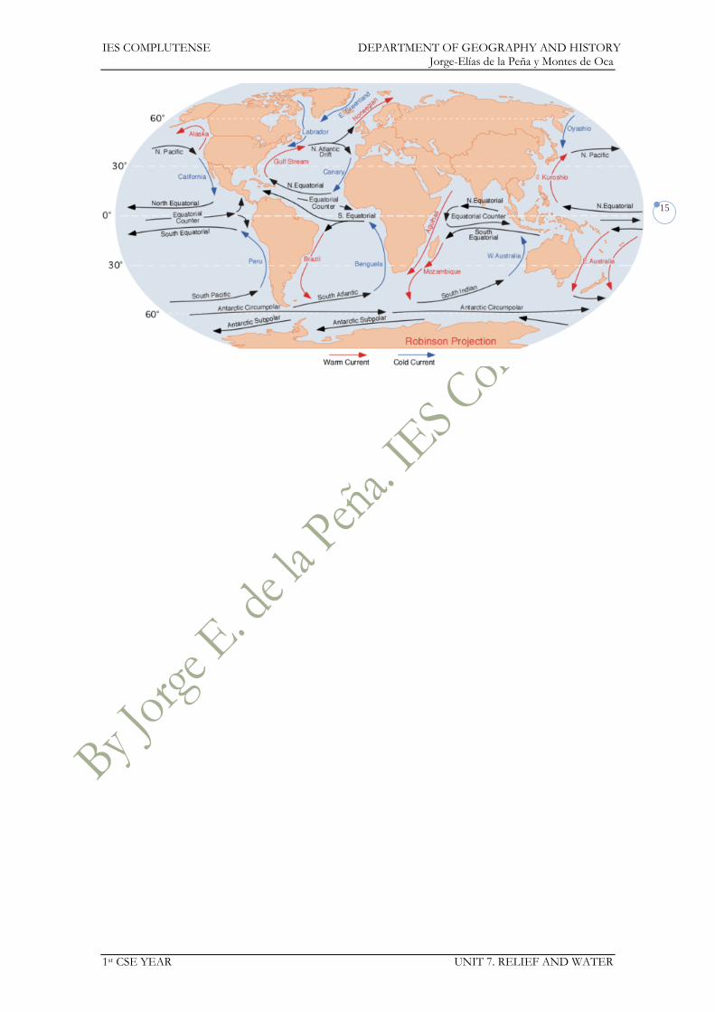
Ocean currents. It is a continuous, directed movement of ocean
water generated by the forces acting upon the water. There can be
two kinds:
Surface currents. They are caused by the wind and they
influence over the coastal climates. There can be two kinds:
o Warm currents. Their source is in the equator and
the tropics and move towards the poles. They usually
temper the temperatures in high latitudes.
o Cold currents. Their source is in polar areas and
move towards the equator. They make rains difficult
and are associated to the best fishing grounds.
Deep currents. They flow around 4 or 5 km deep. They are
caused by the salinity or temperature difference.
IES COMPLUTENSE DEPARTMENT OF GEOGRAPHY AND HISTORY Jorge-Elías de la Peña y Montes de Oca
1st CSE YEAR UNIT 7. RELIEF AND WATER
15

IES COMPLUTENSE DEPARTMENT OF GEOGRAPHY AND HISTORY Jorge-Elías de la Peña y Montes de Oca
1st CSE YEAR UNIT 7. RELIEF AND WATER
16
Unit 7. Relief and waters
Exercises
1. Correct the sentence: Most of the Earth’s oceans are in the northern hemisphere,
while most of the land masses are in the southern hemisphere.
2. Are the following sentences true or false? Correct the wrong ones.
a. Europe and Asia are part of the same continent land mass.
b. The Atlantic Ocean is the biggest and deepest ocean.
c. Capes are coastal areas that stick out into the sea.
3. Which oceans do these seas belong to?
a. Ross.
b. Baltic.
c. Red.
d. Barents.
e. Mediterranean.
f. Caribbean.
g. Arabian.
h. Philippines.
4. Which of these terms do not relate to the ocean floor?
a. Cliff.
b. Abyssal plain.
c. Ocean ridge.
d. Continental slope.
e. Focus.
f. Gulf.
5. What kinds of relief can you find on continents?
6. What kinds of relief can you find under seas and oceans?
7. Correct the mistakes in the sentences:
a. Oceanic ridges are narrow depressions.
b. The continental slope has a mild decline.
c. The abyssal plains are vast territories in shallow waters.
d. Submarine trenches are narrow depressions.
e. The continents extend underneath the oceans forming the continental
shelf.
8. Look at the map of tectonic plates and answer:
a. Where are the most unstable places in the world? Where are the more
stable places?
b. Which areas of Spain are the most unstable?
c. Explain why the Mediterranean Sea is an area of volcanoes and
earthquakes.

IES COMPLUTENSE DEPARTMENT OF GEOGRAPHY AND HISTORY Jorge-Elías de la Peña y Montes de Oca
1st CSE YEAR UNIT 7. RELIEF AND WATER
17
9. If there is an earthquake...
a. Where are the tremors most intense on the surface?
b. Where does the earthquake start?
c. Can the seismic waves pass though rock?
10. Complete the chart and put the things below into the correct columns.
What should you do if there is
an earthquake?
What should you not do if
there is an earthquake?
a. Stay in the building.
b. Turn off the lights.
c. Panic.
d. Turn off the gas and the water.
e. Move objects that might fall on you.
f. Leave the house if the floor starts to tilt.
g. Stay in the car if you are already in it.
h. Use things that need lighting with matches or gas.
11. Describe the parts of a volcano.
12. What happens in a volcanic eruption?
13. List all the external relief agents.
14. Complete the following chart:
IES COMPLUTENSE DEPARTMENT OF GEOGRAPHY AND HISTORY Jorge-Elías de la Peña y Montes de Oca
1st CSE YEAR UNIT 7. RELIEF AND WATER
18
Continent Africa America Antarctica Asia Europe Oceania
Oceans
15. Correct the sentences:
a. Fast rivers deposit sediment and create valleys.
b. When ice in rocks melts, it can break them apart.
c. Cliffs are made when waves and currents deposit sediment on the coast.
d. Wind erosion is greater in places with lots of vegetation.
e. Building roads and cities does not change the landscape.
16. Explain the difference between a delta and an estuary.
17. Explain the difference between the upper course and the lower course of a river.
18. Match the course of the river (upper, middle, or lower) to the characteristics.
a. It can cause erosion.
b. It has a lot of curves.
c. It is the highest part of the river.
d. It may form a delta.
19. Where does the water in a rainfall regime river come from?
20. Where does the water in a melting regime river come from?
21. Put the words in the order they occur in the course of a river:
a. Delta
b. Erosion
c. Waterfall
d. Meander
e. Sea
f. Mouth
g. Glacier
h. Sedimentation
22. Find the words to match these definitions:
a. The place where a river flows into the sea.
b. A frozen mass of water at the head of a river.
c. A part of the river where the water falls vertically.
23. What is an aquifer?
24. Find out what happens of you ever bathe in the Dead Sea.
25. What are the sentences describing?
a. They are produced by the action of the wind on the surface of the water.
b. The Moon’s gravitational pull produces them.
c. The time in a day when the level of the sea on the coast is at its lowest.
d. They can be warm or cold and move like big rivers across oceans.
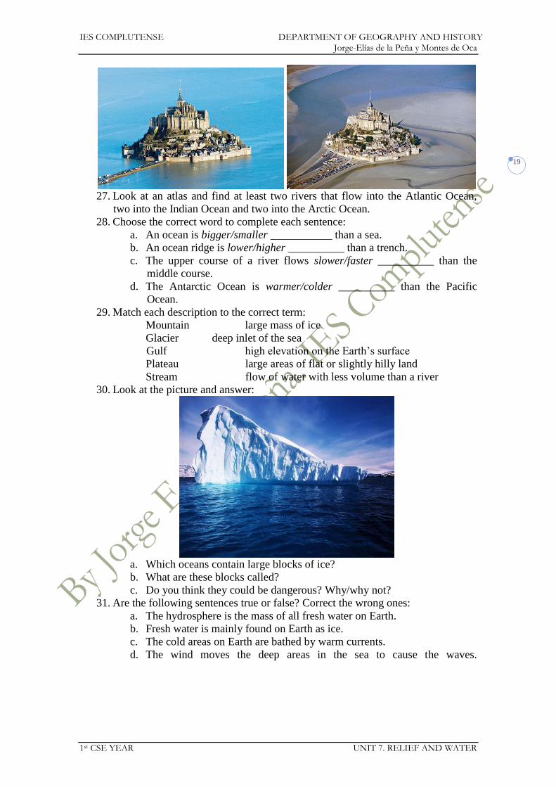
26. Which picture shows high tide? Which one shows low tide?
IES COMPLUTENSE DEPARTMENT OF GEOGRAPHY AND HISTORY Jorge-Elías de la Peña y Montes de Oca
1st CSE YEAR UNIT 7. RELIEF AND WATER
19
27. Look at an atlas and find at least two rivers that flow into the Atlantic Ocean,
two into the Indian Ocean and two into the Arctic Ocean.
28. Choose the correct word to complete each sentence:
a. An ocean is bigger/smaller ___________ than a sea.
b. An ocean ridge is lower/higher __________ than a trench.
c. The upper course of a river flows slower/faster __________ than the
middle course.
d. The Antarctic Ocean is warmer/colder __________ than the Pacific
Ocean.
29. Match each description to the correct term:
Mountain large mass of ice
Glacier deep inlet of the sea
Gulf high elevation on the Earth’s surface
Plateau large areas of flat or slightly hilly land
Stream flow of water with less volume than a river
30. Look at the picture and answer:
a. Which oceans contain large blocks of ice?
b. What are these blocks called?
c. Do you think they could be dangerous? Why/why not?
31. Are the following sentences true or false? Correct the wrong ones:
a. The hydrosphere is the mass of all fresh water on Earth.
b. Fresh water is mainly found on Earth as ice.
c. The cold areas on Earth are bathed by warm currents.
d. The wind moves the deep areas in the sea to cause the waves.
IES COMPLUTENSE DEPARTMENT OF GEOGRAPHY AND HISTORY Jorge-Elías de la Peña y Montes de Oca
1st CSE YEAR UNIT 8. CLIMATE
1
Social Science 1st CSE
UNIT 8: Climate

IES COMPLUTENSE DEPARTMENT OF GEOGRAPHY AND HISTORY Jorge-Elías de la Peña y Montes de Oca
1st CSE YEAR UNIT 8. CLIMATE
2
UNIT 8: CLIMATE
1. CLIMATE’S ELEMENTS
Climate and weather are different concepts that are usually confused:
o Weather is the present condition of these elements and their variations over
shorter periods. It is studied by the meteorology.
o Instead, climate is the term for the average atmospheric conditions over
longer periods of time (usually over 30 years). It is studied by the
climatology.
To identify a climate some elements are measured:
o Temperature. It measures how hot the air is.
It can be expressed in several kinds of degrees:
Celsius (ºC). They base on the different states of water (solid,
liquid, gaseous). Below 0ºC water freezes, over 100ºC water
boils and turns into vapour.
Fahrenheit (ºF). It is widely used in North America and has
no relationship to states of water.
Kelvin (K). It bases on the absolute zero (-273ºC).
The thermometer measures the temperatures.
They are usually represented on the maps through isotherms.
There are several factors that make temperatures vary:
Latitude. The sun falls on the earth in a different way
according to the latitude, hence the difference of temperatures
of the regions.
Altitude. It descends as we are higher in a proportion of
0.6ºC every 100 metres (c. 1ºC every 160 m).
Coastal locations. Sea currents influence over the
temperatures and make them milder. The farther a place is
from the coast the more extreme its temperatures are.
o Precipitations. It is the water fallen from the sky in a solid (snow or hail) or
liquid state (rain).

IES COMPLUTENSE DEPARTMENT OF GEOGRAPHY AND HISTORY Jorge-Elías de la Peña y Montes de Oca
1st CSE YEAR UNIT 8. CLIMATE
3
They are expressed either in millimetres (mm) or litres/square
kilometre (l/km2).
They are measured with a pluviometer or rain gauge.
They are represented on the maps through isohyets.
There are also several factors that make precipitations vary:
Latitude. There are many more precipitations in the equator
due to the warm and humid air that eases evaporation.
Altitude. It rains more in high areas.
Coastal location. Warm sea currents also favour rains, but
cold sea currents make them difficult. Anyway coastal
regions are usually rainier than inland regions.
o Atmospheric pressure. It is the weight of air above the surface.
In meteorology it is expressed in millibars (mb) or hectopascals
(hPa).
It is measured with the barometer.

IES COMPLUTENSE DEPARTMENT OF GEOGRAPHY AND HISTORY Jorge-Elías de la Peña y Montes de Oca
1st CSE YEAR UNIT 8. CLIMATE
4
It is represented on the maps through isobars.
Pressure is lower as the altitude increases because there is less air
above those regions.
o Air moisture. It is the amount of water vapour in the air.
When it is the relative air moisture it is expressed in percentages
(%).
It is measured with the hygrometer.
Cold air cannot withstand much air moisture. Instead warm air can
do.
o Wind. It is the movement of air due to the pressure differences. It re-
establishes pressure balance.
It is expressed in kilometres/hour (km/h).
It is measured with an anemometer.
Its direction is known thanks to the weathercock or weather vane.
2. CLIMATE’S FACTORS
All the climatic phenomena take place in the troposphere (the lowest atmospheric
layer).
The atmospheric circulation explains why climates are different and why weather
changes:

IES COMPLUTENSE DEPARTMENT OF GEOGRAPHY AND HISTORY Jorge-Elías de la Peña y Montes de Oca
1st CSE YEAR UNIT 8. CLIMATE
5
o Air masses. It is a volume of air defined by its temperature and water vapour
content.
Their characteristics depend on the source region they are originated.
They can either be dry or humid; either warm or cold.
They move due to the difference of temperatures, air moisture, and
pressure.
o Pressure centres. The average pressure is 1013.5 mb or hPa but the
atmosphere is never stable:
Above 1013.5 mb or hPa it is high pressure or anticyclone. It
circulates clockwise in the northern hemisphere, whereas in the
southern hemisphere it does counterclockwise.
High pressures usually involve dry and sunny weather. It can
be either cold or warm.
The usual high pressure areas are the poles and the tropics.
Below 1013.5 mb or hPa it is low pressure or low or depression. It
circulates counterclockwise in the northern hemisphere, whereas in
the southern hemisphere it does clockwise.
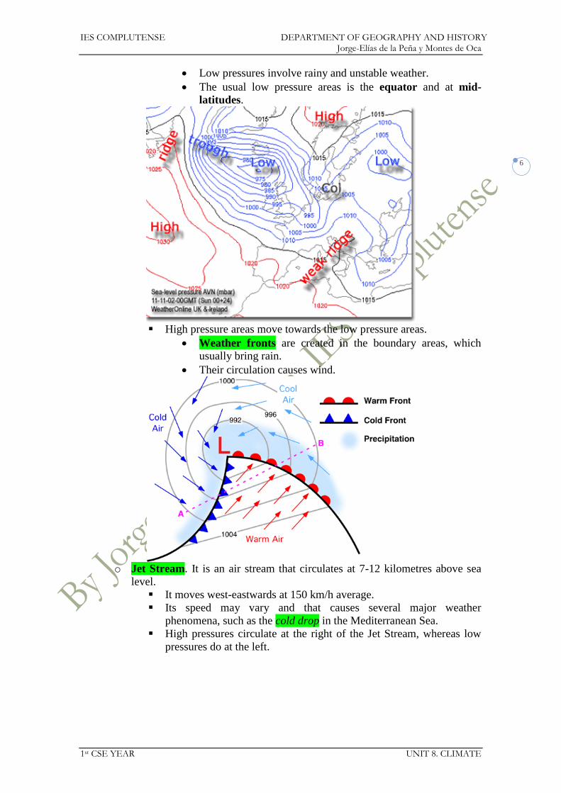
IES COMPLUTENSE DEPARTMENT OF GEOGRAPHY AND HISTORY Jorge-Elías de la Peña y Montes de Oca
1st CSE YEAR UNIT 8. CLIMATE
6
Low pressures involve rainy and unstable weather.
The usual low pressure areas is the equator and at mid-
latitudes.
High pressure areas move towards the low pressure areas.
Weather fronts are created in the boundary areas, which
usually bring rain.
Their circulation causes wind.
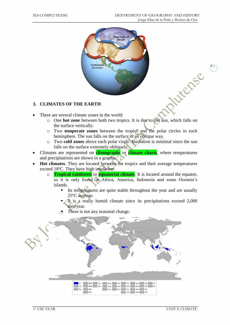
o Jet Stream. It is an air stream that circulates at 7-12 kilometres above sea
level.
It moves west-eastwards at 150 km/h average.
Its speed may vary and that causes several major weather
phenomena, such as the cold drop in the Mediterranean Sea.
High pressures circulate at the right of the Jet Stream, whereas low
pressures do at the left.
IES COMPLUTENSE DEPARTMENT OF GEOGRAPHY AND HISTORY Jorge-Elías de la Peña y Montes de Oca
1st CSE YEAR UNIT 8. CLIMATE
7
3. CLIMATES OF THE EARTH
There are several climate zones in the world:
o One hot zone between both two tropics. It is due to the sun, which falls on
the surface vertically.
o Two temperate zones between the tropics and the polar circles in each
hemisphere. The sun falls on the surface in an oblique way.
o Two cold zones above each polar circle. Insolation is minimal since the sun
falls on the surface extremely obliquely.
Climates are represented on climographs or climate charts, where temperatures
and precipitations are shown in a graphic.
Hot climates. They are located between the tropics and their average temperatures
exceed 18ºC. They have high insolation:
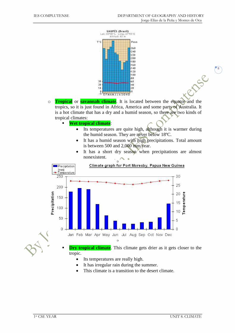
o Tropical rainforest or equatorial climate. It is located around the equator,
so it is only found in Africa, America, Indonesia and some Oceania’s
islands.
Its temperatures are quite stable throughout the year and are usually
25ºC average.
It is a really humid climate since its precipitations exceed 2,000
mm/year.
There is not any seasonal change.
IES COMPLUTENSE DEPARTMENT OF GEOGRAPHY AND HISTORY Jorge-Elías de la Peña y Montes de Oca
1st CSE YEAR UNIT 8. CLIMATE
8
o Tropical or savannah climate. It is located between the equator and the
tropics, so it is just found in Africa, America and some parts of Australia. It
is a hot climate that has a dry and a humid season, so there are two kinds of
tropical climates:
Wet tropical climate:
Its temperatures are quite high, although it is warmer during
the humid season. They are never below 18ºC.
It has a humid season with high precipitations. Total amount
is between 500 and 2,000 mm/year.
It has a short dry season when precipitations are almost
nonexistent.
Dry tropical climate. This climate gets drier as it gets closer to the
tropic.
Its temperatures are really high.
It has irregular rain during the summer.
This climate is a transition to the desert climate.

IES COMPLUTENSE DEPARTMENT OF GEOGRAPHY AND HISTORY Jorge-Elías de la Peña y Montes de Oca
1st CSE YEAR UNIT 8. CLIMATE
9
o Hot desert climate. It is usually located close to the tropics.
It is a really hot climate during the day (c. 50ºC), but it cools during
the night (c. 0ºC). However its average temperature is above 18ºC.
It is extremely dry, since it rains less than 250 mm/year. When it
rains in falls as heavy downpours.

IES COMPLUTENSE DEPARTMENT OF GEOGRAPHY AND HISTORY Jorge-Elías de la Peña y Montes de Oca
1st CSE YEAR UNIT 8. CLIMATE
10
Temperate climates. They are located between the tropics and the polar circles. All
of them have four different seasons with changes in temperatures and precipitations.
o Oceanic climate. It is usually a climate located on the west coasts of the
continents at mid-latitude:
Its temperatures are quite mild, since its average is between 10 and
15ºC.
It has regular and abundant rain, more usual in winter. It exceeds
1,000 mm/year.

IES COMPLUTENSE DEPARTMENT OF GEOGRAPHY AND HISTORY Jorge-Elías de la Peña y Montes de Oca
1st CSE YEAR UNIT 8. CLIMATE
11
o Mediterranean climate. It is mostly located around the Mediterranean Sea,
although it has some other locations in South Africa, California, Chile, and
Australia:
Its winter is quite mild, but its summer is hot and dry. Its average
temperature is around 15ºC.
Precipitations are quite irregular and non-abundant (never over 800
mm/year). They are more common in spring and autumn.
IES COMPLUTENSE DEPARTMENT OF GEOGRAPHY AND HISTORY Jorge-Elías de la Peña y Montes de Oca
1st CSE YEAR UNIT 8. CLIMATE
12
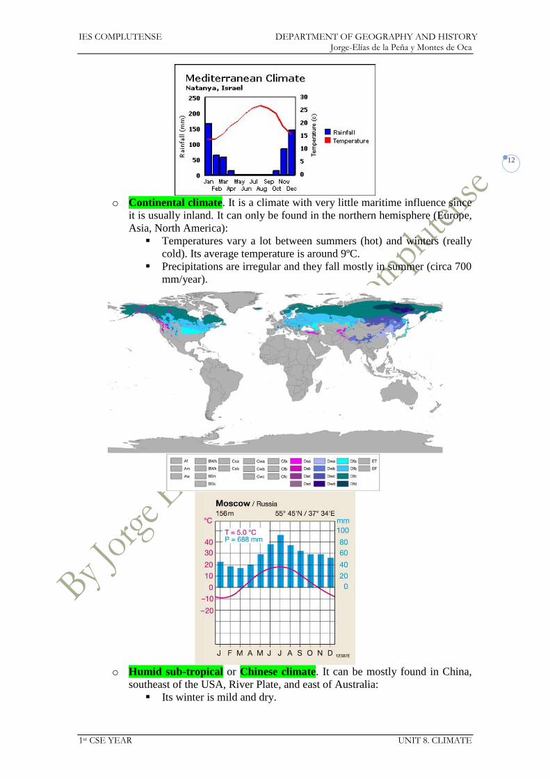
o Continental climate. It is a climate with very little maritime influence since
it is usually inland. It can only be found in the northern hemisphere (Europe,
Asia, North America):
Temperatures vary a lot between summers (hot) and winters (really
cold). Its average temperature is around 9ºC.
Precipitations are irregular and they fall mostly in summer (circa 700
mm/year).
o Humid sub-tropical or Chinese climate. It can be mostly found in China,
southeast of the USA, River Plate, and east of Australia:
Its winter is mild and dry.

IES COMPLUTENSE DEPARTMENT OF GEOGRAPHY AND HISTORY Jorge-Elías de la Peña y Montes de Oca
1st CSE YEAR UNIT 8. CLIMATE
13
Summer is really hot (almost tropical) and rainy.
Precipitations are above 1,000 mm/year, whereas the average
temperature is between 15 and 20ºC.
Cold climates. They are located in high latitudes and altitudes.
o Polar climate. It is located above the polar circles:
There is not any warm summer.
Average temperatures are around 0ºC and they can reach up to -50ºC.
There are very few precipitations (less than 300 mm/year), although
they remain frozen due to the extremely low temperatures.

IES COMPLUTENSE DEPARTMENT OF GEOGRAPHY AND HISTORY Jorge-Elías de la Peña y Montes de Oca
1st CSE YEAR UNIT 8. CLIMATE
14
o Alpine climate. It is located in the highest mountains of the world:
Its temperatures are quite low, since their average does not exceed
5ºC.
It is a rainy climate with more than 1,500 mm/year.
4. CLIMATIC HAZARDS
There are some climatic risks that can affect many regions of the world:
o Drought. It happens when it does not rain over a long period of time. It is
quite typical in some areas such as the Horn of Africa.
o Flooding. It happens when it rains a lot over a short period of time and the
land cannot absorb all the water. It is quite common in areas like southeast
China.
o Cyclones (hurricane in the Caribbean area, typhoon in Southeast Asia,
willy willies in Australia). They are very strong winds that bring heavy rain.
There are 5 categories following the Saffir-Simpson scale, which
measures the wind speed.
Sustained winds can reach more than 250 km/h.
They are really destructive.
They form swirling clouds around an eye, which is the centre of the
cyclone.

IES COMPLUTENSE DEPARTMENT OF GEOGRAPHY AND HISTORY Jorge-Elías de la Peña y Montes de Oca
1st CSE YEAR UNIT 8. CLIMATE
15
They take place when the temperature of the ocean exceeds 27ºC and
between 5-15º N/S.
o Tornadoes. They are violent, dangerous, rotating column of air that is in
contact with both the surface of the earth and a cloud.
There are also 5 categories based on the Fujita scale (F0-F5).
They are common in the centre of the USA at 20-50ºN.
They can reach more than 480 km/h.

IES COMPLUTENSE DEPARTMENT OF GEOGRAPHY AND HISTORY Jorge-Elías de la Peña y Montes de Oca
1st CSE YEAR UNIT 8. CLIMATE
16
Unit 8. Climate
Exercises
1. Who speaks about the weather and who does it about climate?
a. It rains a lot in spring in my town.
b. It is very hot and sunny today. Let us go to the beach.
2. Which sentences speak about weather and which ones about climate?
a. It does not usually rain in Seville in summer.
b. Yesterday, there was a very heavy storm in Zaragoza.
c. It is very cold in Siberia in winter.
d. I heard on the radio that is it going to be very cold in Valladolid
tomorrow.
3. Where do atmospheric phenomena exist?
4. Order the letters to make words. Then write the definition for each word:
a. Sephmoreat
b. Roetaptinpic
c. Aimtcle
d. Inwd
5. Match each term to the correct measuring instrument.
Temperature weather vane
Atmospheric pressure thermometer
Wind speed barometer
Precipitation wind gauge/anemometer
Wind direction rain gauge/pluviometer
6. How does altitude modify temperature?
7. What is the temperature oscillation?
8. How does the sea affect temperatures in summer?
9. Say the words that define the following items:
a. The study of climate.
b. The study of atmospheric phenomena.
c. The layer of gases around the Earth.
d. Area of high pressure.
e. Water falling from the atmosphere.
f. Area or low pressure.
10. Answer whether it is true or false. Correct the wrong ones.
a. The higher the altitude, the greater the atmospheric pressure.
b. Warm air rises because it weighs less.
c. Depressions are caused by cold air.
d. When air moves from low pressure areas to high pressure areas, winds
are produced.
11. What is the instrument that measures the amount of water fallen? How is it
expressed?
12. Many expressions in English refer to the weather. Use a dictionary to match
each expression to the correct meaning:
She’s a bit under the weather. She’s got a lot of work to do.
She’s snowed under. She’s not in touch with the
real world.
She’s got her head in the clouds. She’s not feeling very well.
IES COMPLUTENSE DEPARTMENT OF GEOGRAPHY AND HISTORY Jorge-Elías de la Peña y Montes de Oca
1st CSE YEAR UNIT 8. CLIMATE
17
She’s got a face like thunder. She looks very angry.
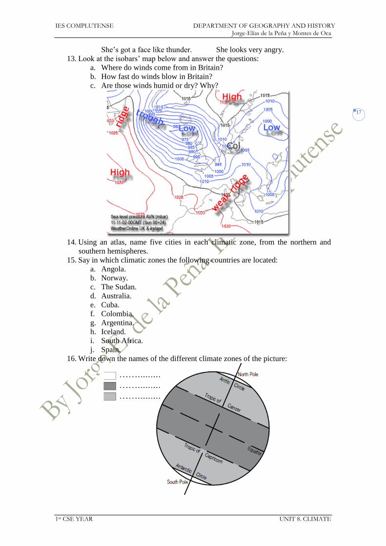
13. Look at the isobars’ map below and answer the questions:
a. Where do winds come from in Britain?
b. How fast do winds blow in Britain?
c. Are those winds humid or dry? Why?
14. Using an atlas, name five cities in each climatic zone, from the northern and
southern hemispheres.
15. Say in which climatic zones the following countries are located:
a. Angola.
b. Norway.
c. The Sudan.
d. Australia.
e. Cuba.
f. Colombia.
g. Argentina.
h. Iceland.
i. South Africa.
j. Spain.
16. Write down the names of the different climate zones of the picture:

IES COMPLUTENSE DEPARTMENT OF GEOGRAPHY AND HISTORY Jorge-Elías de la Peña y Montes de Oca
1st CSE YEAR UNIT 8. CLIMATE
18
17. Match each climate to its climate zone:
Mediterranean
Tropical
Alpine Hot
Polar Temperate
Equatorial Cold
Continental
Oceanic
Desert
18. Answer the following questions:
a. Which climates have the most precipitation?
b. And which the least?
19. In what way is the equatorial climate different from the wet tropical climate?
20. Answer the following questions:
a. What are temperatures like in a polar climate?
b. Is there much precipitation? Is it in form of rain or snow?
c. What is the main difference between the Mediterranean climate and the
humid sub-tropical climate?
21. Which climate type has the lower temperatures?
22. Are the following sentences true or false? Correct the wrong ones.
a. An equatorial climate is always humid and hot.
b. The polar and alpine climates have the lowest temperatures.
c. The tropical climate is a kind of temperate climate.
d. The oceanic climate is hot in summer and cold in winter.
23. Match each natural hazard to the correct definition:
Hail very strong wind and heavy rain
Storm small, hard balls of ice
Drought period of very hot weather
Cyclone long period without rain
High temperatures heavy rain, thunder and lightning
24. Are the following statements true or false? Correct the wrong ones.
a. The atmosphere is the layer of gases that surrounds the Earth.
b. Meteorological phenomena occur in the atmosphere.
c. Climate is the same all over the planet.
d. The temperate zone is located between 30º and 60º latitude north and
south.
e. The equatorial climate has very little precipitation and strong contrasts in
temperature.
f. Cyclones can cause great disasters.
25. Complete the chart with the actions below in the correct columns.
What to do in a
drought
What to do in a
flood
What to do in a
storm
IES COMPLUTENSE DEPARTMENT OF GEOGRAPHY AND HISTORY Jorge-Elías de la Peña y Montes de Oca
1st CSE YEAR UNIT 8. CLIMATE
19
a. Put bottles of water in the toilet cistern to reduce its capacity and save
water.
b. In the countryside, do not go near rivers, torrents or flooded areas.
c. At home, shut doors and windows to stop air currents because they attract
lightning.
d. Turn off the tap when you brush your teeth.
e. In the countryside, do not climb to the top of hills or shelter under trees.
f. If the house is flooded, do not shelter in the cellar or on the ground floor.
g. Do not park or camp near a river in case the water level rises.
h. Only use the washing machine and the dishwasher when they are full.
i. Switch off your mobile phone.
j. Do not touch metal objects.
IES COMPLUTENSE DEPARTMENT OF GEOGRAPHY AND HISTORY Jorge-Elías de la Peña y Montes de Oca
1st CSE YEAR UNIT 9. THE EARTH’S LANDSCAPES
1
Social Science 1st CSE
UNIT 9: The Earth’s landscapes
IES COMPLUTENSE DEPARTMENT OF GEOGRAPHY AND HISTORY Jorge-Elías de la Peña y Montes de Oca
1st CSE YEAR UNIT 9. THE EARTH’S LANDSCAPES
2
UNIT 9: THE EARTH’S LANDSCAPES
1. HOT CLIMATE LANDSCAPES
1.1. Equatorial landscapes
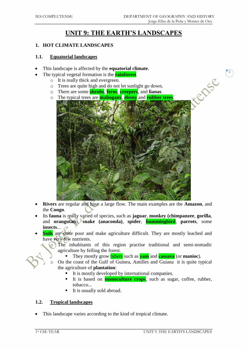
This landscape is affected by the equatorial climate.
The typical vegetal formation is the rainforest.
o It is really thick and evergreen.
o Trees are quite high and do not let sunlight go down.
o There are some shrubs, ferns, creepers, and lianas.
o The typical trees are mahogany, ebony and rubber trees.
Rivers are regular and have a large flow. The main examples are the Amazon, and
the Congo.
Its fauna is really varied of species, such as jaguar, monkey (chimpanzee, gorilla,
and orangutan), snake (anaconda), spider, hummingbird, parrots, some
insects...
Soils are quite poor and make agriculture difficult. They are mostly leached and
have very few nutrients.
o The inhabitants of this region practise traditional and semi-nomadic
agriculture by felling the forest.
They mostly grow tubers such as yam and cassava (or manioc).
o On the coast of the Gulf of Guinea, Antilles and Guiana it is quite typical
the agriculture of plantation:
It is mostly developed by international companies.
It is based on monoculture crops, such as sugar, coffee, rubber,
tobacco...
It is usually sold abroad.
1.2. Tropical landscapes
This landscape varies according to the kind of tropical climate.

IES COMPLUTENSE DEPARTMENT OF GEOGRAPHY AND HISTORY Jorge-Elías de la Peña y Montes de Oca
1st CSE YEAR UNIT 9. THE EARTH’S LANDSCAPES
3
The wet tropical climate has a very similar landscape to the equatorial climate.
The dry tropical climate can have several kinds of landscapes:
o The most important formation is the savannah:
It is a grassland ecosystem characterised by the trees being
sufficiently small or widely spaced so that the canopy does not close.
They typical species are acacia and baobab.
The open canopy allows sufficient light to reach the ground to
support an unbroken herbaceous layer.
They can grow up to 4 metres in the humid season.
o Around the rivers grows the gallery forest composed of species than need a
lot of water and that make a quite thick forest.
o Next to the desert areas the steppe is usual, since there is very little water
and that does not let trees grow.
Rivers are slightly irregular with high rises in flow during the humid season and
low water during the dry season. Major tropical rivers are the Orinoco, the
Zambezi, and the upper course of the Nile.
Its fauna is really important since the great mammals live in this kind of landscape,
such as the lion, cheetah, elephant, giraffe, zebra, hyena, rhinoceros,
hippopotamus, antelope...
Soils are not really rich either and that makes agriculture difficult. It is mostly
unirrigated agriculture with several kinds of crops.
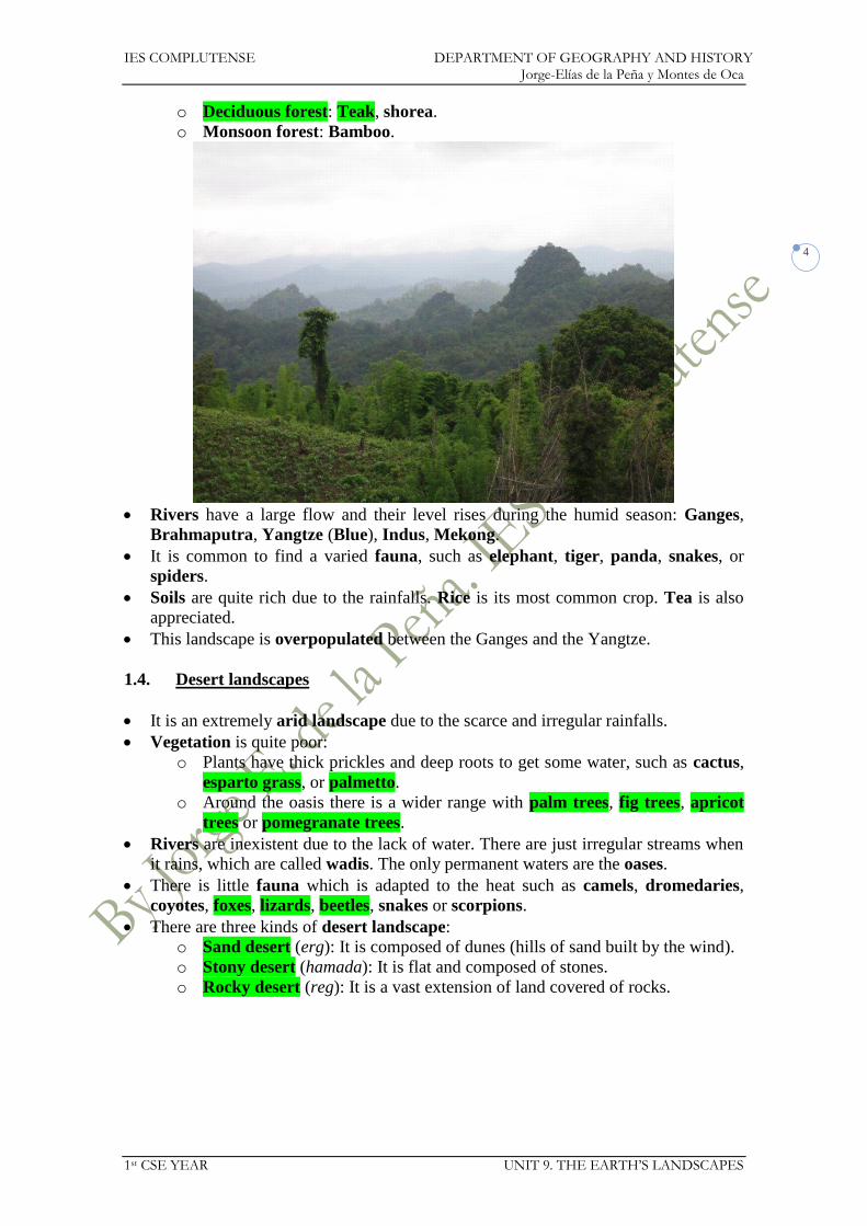
1.3. Monsoon Asian landscapes
It is located in Southeast Asia (India, Bangladesh, Burma, Indochina and southeast
China).
This landscape is affected by the monsoon, a kind of wind with two major
characteristics basing on the season:
o Winter monsoon. It is cold and dry wind that blows from Central Asia
towards the Indian Ocean.
o Summer monsoon. It is a warm and humid wind that blows from the Indian
Ocean towards Central Asia.
The vegetation is exposed to massive summer rainfalls:
IES COMPLUTENSE DEPARTMENT OF GEOGRAPHY AND HISTORY Jorge-Elías de la Peña y Montes de Oca
1st CSE YEAR UNIT 9. THE EARTH’S LANDSCAPES
4
o Deciduous forest: Teak, shorea.
o Monsoon forest: Bamboo.
Rivers have a large flow and their level rises during the humid season: Ganges,
Brahmaputra, Yangtze (Blue), Indus, Mekong.
It is common to find a varied fauna, such as elephant, tiger, panda, snakes, or
spiders.
Soils are quite rich due to the rainfalls. Rice is its most common crop. Tea is also
appreciated.
This landscape is overpopulated between the Ganges and the Yangtze.
1.4. Desert landscapes
It is an extremely arid landscape due to the scarce and irregular rainfalls.
Vegetation is quite poor:
o Plants have thick prickles and deep roots to get some water, such as cactus,
esparto grass, or palmetto.
o Around the oasis there is a wider range with palm trees, fig trees, apricot
trees or pomegranate trees.
Rivers are inexistent due to the lack of water. There are just irregular streams when
it rains, which are called wadis. The only permanent waters are the oases.
There is little fauna which is adapted to the heat such as camels, dromedaries,
coyotes, foxes, lizards, beetles, snakes or scorpions.
There are three kinds of desert landscape:
o Sand desert (erg): It is composed of dunes (hills of sand built by the wind).
o Stony desert (hamada): It is flat and composed of stones.
o Rocky desert (reg): It is a vast extension of land covered of rocks.

IES COMPLUTENSE DEPARTMENT OF GEOGRAPHY AND HISTORY Jorge-Elías de la Peña y Montes de Oca
1st CSE YEAR UNIT 9. THE EARTH’S LANDSCAPES
5
2. TEMPERATE CLIMATE LANDSCAPES
2.1. Oceanic landscape
The mild temperatures and the abundant precipitation let have a lot of vegetation:
o Oceanic deciduous forest: It is mostly composed of high trees such as oak,
beech, chestnut tree, elm or ash.
o Scrubland or moors: In the areas where the oceanic forest disappears it is
common to have bushes such as retama or heather.
o Grasslands: It is common in the plains and it is the basis of the pastures.
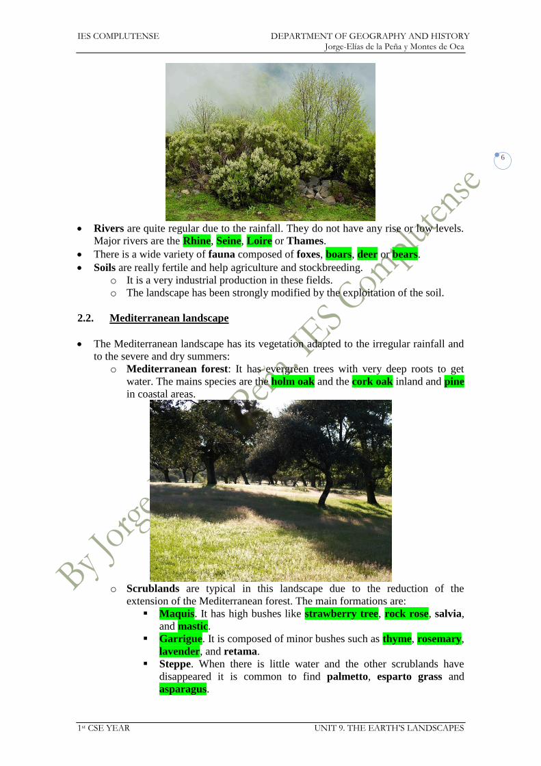
IES COMPLUTENSE DEPARTMENT OF GEOGRAPHY AND HISTORY Jorge-Elías de la Peña y Montes de Oca
1st CSE YEAR UNIT 9. THE EARTH’S LANDSCAPES
6
Rivers are quite regular due to the rainfall. They do not have any rise or low levels.
Major rivers are the Rhine, Seine, Loire or Thames.
There is a wide variety of fauna composed of foxes, boars, deer or bears.
Soils are really fertile and help agriculture and stockbreeding.
o It is a very industrial production in these fields.
o The landscape has been strongly modified by the exploitation of the soil.
2.2. Mediterranean landscape
The Mediterranean landscape has its vegetation adapted to the irregular rainfall and
to the severe and dry summers:
o Mediterranean forest: It has evergreen trees with very deep roots to get
water. The mains species are the holm oak and the cork oak inland and pine
in coastal areas.
o Scrublands are typical in this landscape due to the reduction of the
extension of the Mediterranean forest. The main formations are:
Maquis. It has high bushes like strawberry tree, rock rose, salvia,
and mastic.
Garrigue. It is composed of minor bushes such as thyme, rosemary,
lavender, and retama.
Steppe. When there is little water and the other scrublands have
disappeared it is common to find palmetto, esparto grass and
asparagus.

IES COMPLUTENSE DEPARTMENT OF GEOGRAPHY AND HISTORY Jorge-Elías de la Peña y Montes de Oca
1st CSE YEAR UNIT 9. THE EARTH’S LANDSCAPES
7
Rivers are quite irregular and have major rises and low level periods.
o Most of them are quite short due to the fact that their source is close to the
sea.
o The main rivers are Ebro, Rhone, and Po.
It has a quite varied fauna composed of rabbits, foxes, deer, wolves, boars,
squirrels, eagles, vultures, and sparrows.
Soils are quite poor, but in the valleys. There are different kinds of agriculture:
o Unirrigated agriculture: It is the most common agriculture, based on three
typical crops: wheat, vines, and olive tree.
o Irrigated agriculture: It is common in the coastal plains and in other
regions with greenhouses. They usually grow vegetables, legumes or fruits.
Tourism has developed a lot in this landscape. It is mostly based on sun and
beaches.
2.3. Continental climate
The northernmost continental landscape is defined by the coniferous forest (taiga):
o It has evergreen trees such as the pine and fir.
o Some other trees are larch or birch.
The southern continental landscape is defined by two kinds of formations:
o The areas which are cooler and more humid have large prairies, composed
of high grass, such in the American Midwest.
o The areas which are warmer and drier have steppes, composed of low grass,
like in East Europe or Central Asia.

IES COMPLUTENSE DEPARTMENT OF GEOGRAPHY AND HISTORY Jorge-Elías de la Peña y Montes de Oca
1st CSE YEAR UNIT 9. THE EARTH’S LANDSCAPES
8
Rivers have a large flow with important rises in the level in spring because of the
thaw. They are frozen in winter. Major rivers are Volga, Danube or Missouri.
Its fauna is adapted to the extreme temperatures and it is mostly composed by
moose, reindeers, bears, lynxes, wolves, otters, marmots, ferrets, ravens and
owls.
Soils are really different according to the region:
o Prairies are quite fertile and make agriculture possible. It is quite common
to have large plantations of corn and wheat.
o Steppes and taiga are quite barren and are almost uninhabited.
3. COLD CLIMATE LANDSCAPES
3.1. Polar landscape
It is located above the Polar circles.
There is no vegetation owing to the perpetual ice.
There are not rivers either.
Its fauna is adapted to the extreme cold. There are animals like penguins, whales,
polar bears, seals, and walrus.
In the Arctic and Antarctic Oceans it is common to have floating ice blocks called
icebergs that are fragments which have detached from the icefield that covers the
whole ocean.
Antarctica is a continent completely covered of snow and really thick ice over the
land called ice sheet.
o It is a completely uninhabited continent. Only scientists have settled there to
study it.

IES COMPLUTENSE DEPARTMENT OF GEOGRAPHY AND HISTORY Jorge-Elías de la Peña y Montes de Oca
1st CSE YEAR UNIT 9. THE EARTH’S LANDSCAPES
9
Border lands have a milder climate:
o Their vegetation appears after the thaw and it is based on tundra, which is
composed of lichens and moss.
o Their soils are quite infertile and their surface is quite muddy after the thaw,
but it remains frozen in lower strata. They are called permafrost.
3.2. Alpine landscape
This landscape is adapted to the severe cold winters
Vegetation is in tiers and varies according to the altitude owing to the difference of
temperatures and humidity.
o In the lower levels the vegetation has the same features of the region where
the mountains are.
o In middle levels deciduous forest is common, alternating with some conifers.
o In the upper levels meadows and little flowers are the only species that can
grow due to the fact that part of the year this stratum is completely covered
of snow.
The fauna is composed of major birds such as the condor, vulture or eagle and
some mammals such as the mountain goat and chamois.
Soils are not fertile due to the erosion.
In developed countries it is common to build ski resorts in this area.
In hot areas (Africa, South America), these regions are overpopulated owing to the
milder weather conditions.
IES COMPLUTENSE DEPARTMENT OF GEOGRAPHY AND HISTORY Jorge-Elías de la Peña y Montes de Oca
1st CSE YEAR UNIT 9. THE EARTH’S LANDSCAPES
10
Unit 9. The Earth’s landscapes
Exercises
1. Complete the chart:
Type of climate Natural landscape
Equatorial
Continental
Polar
2. Are the following sentences true or false? Correct the wrong ones.
a. There are no hot climate landscapes in the southern hemisphere.
b. There are grasslands and steppes in both hemispheres.
c. Tundra is a typical landscape in temperate climate zones.
3. Research which trees grow in the savannah.
4. Which animals live in the savannah?
5. Find the odd one out and explain why.
a. Savannah, hot desert, palm, steppe.
b. Snake, lion, scorpion, camel.
c. Equatorial rainforest, tropical rainforest, hot desert, perpetual ice.
d. Oak, teak, grass, acacia.
6. Match the landscape in each photo to the right term: savannah, hot desert,
equatorial rainforest.

IES COMPLUTENSE DEPARTMENT OF GEOGRAPHY AND HISTORY Jorge-Elías de la Peña y Montes de Oca
1st CSE YEAR UNIT 9. THE EARTH’S LANDSCAPES
11
7. One of the following animals could not live in the hot desert. Which one? Why?
a. Jackal.
b. Dromedary.
c. Snake.
d. Seal.
8. Match each landscape to the animal that lives there:
Tropical rainforest ape
Equatorial rainforest giraffe
Hot desert puma
Savannah camel
9. Correct the sentences:
a. Deserts are usually very hot at night.
b. A tundra environment is made up of deciduous and coniferous forests.
c. There are many rivers in desert landscapes.
10. Research what thyme and rosemary are used for and what products are obtained
from holm oaks and cork oaks.
11. Find out how tree in the Mediterranean forest adapt to drought.
12. Complete the sentences with the words below:
Evergreen mild scrubland flooding
a. Mediterranean winters are __________ because of the proximity to the
sea.
b. Mediterranean forests are made up of ___________ trees.
c. Maquis and Garrigue are types of ____________.
d. Intense autumn storms can cause __________.
13. Match each type of vegetation to the landscape in which it is found:
beech
rosemary
Mediterranean scrubland thyme
Deciduous forest bamboo
Humid sub-tropical forest pine
oak
14. Match each adjective to its right definition:
Leafy with leaves all year round
Deciduous losing their leaves in autumn
Coniferous lasting forever
Evergreen with a lot of trees and plants
Perpetual producing cones and with needle-like
leaves
15. Why do you think the continental climate does not exist in the southern
hemisphere?

IES COMPLUTENSE DEPARTMENT OF GEOGRAPHY AND HISTORY Jorge-Elías de la Peña y Montes de Oca
1st CSE YEAR UNIT 9. THE EARTH’S LANDSCAPES
12
16. What kind of vegetation can be found the following landscapes:
a. Moor.
b. Steppe (continental).
c. Meadow.
d. Taiga.
17. Say which of these natural landscapes it is nearly impossible for a human being
to survive in and why:
a. Deciduous forest.
b. Coniferous forest.
c. Perpetual ice.
d. Hot desert.
18. Complete the chart with the kinds of climate:
Natural landscape Climate
Tundra
Savannah
Coniferous forest
Equatorial rainforest
Deciduous forest
IES COMPLUTENSE DEPARTMENT OF GEOGRAPHY AND HISTORY Jorge-Elías de la Peña y Montes de Oca
1st CSE YEAR UNIT 10. THE CONTINENTS
1
Social Science 1st CSE
UNIT 10: The continents: Africa, Asia, America, and Oceania

IES COMPLUTENSE DEPARTMENT OF GEOGRAPHY AND HISTORY Jorge-Elías de la Peña y Montes de Oca
1st CSE YEAR UNIT 10. THE CONTINENTS
1
UNIT 10: THE CONTINENTS:
AFRICA, ASIA, AMERICA, AND OCEANIA
1. AFRICA
SEAS OF AFRICA/MARES DE ÁFRICA
Atlantic Ocean Océano Atlántico
Indian Ocean Océano Índico
Mar Mediterráneo Mar Mediterráneo
Red Sea Mar Rojo
STRAITS AND CHANNELS OF AFRICA/ESTRECHOS Y CANALES DE ÁFRICA
Strait of Gibraltar Estrecho de Gibraltar

IES COMPLUTENSE DEPARTMENT OF GEOGRAPHY AND HISTORY Jorge-Elías de la Peña y Montes de Oca
1st CSE YEAR UNIT 10. THE CONTINENTS
2
ISLANDS OF AFRICA/ISLAS DE ÁFRICA
Canary Islands
Islas Canarias Madagascar
Madeira Comoros
Comoras Cape Verde Cabo Verde
Seychelles São Tomé e Príncipe Santo Tomé y Príncipe
GULFS AND BAYS OF ÁFRICA/GOLFOS DE ÁFRICA
Gulf of Guinea
Golfo de Guinea Gulf of Gabes
Golfo de Gabés Gulf of Sidra
Golfo de Sidra Gulf of Aden
Golfo de Adén
CAPES OF AFRICA/CABOS DE ÁFRICA
Verde Agulhas
López
Guardafui Good Hope Buena Esperanza
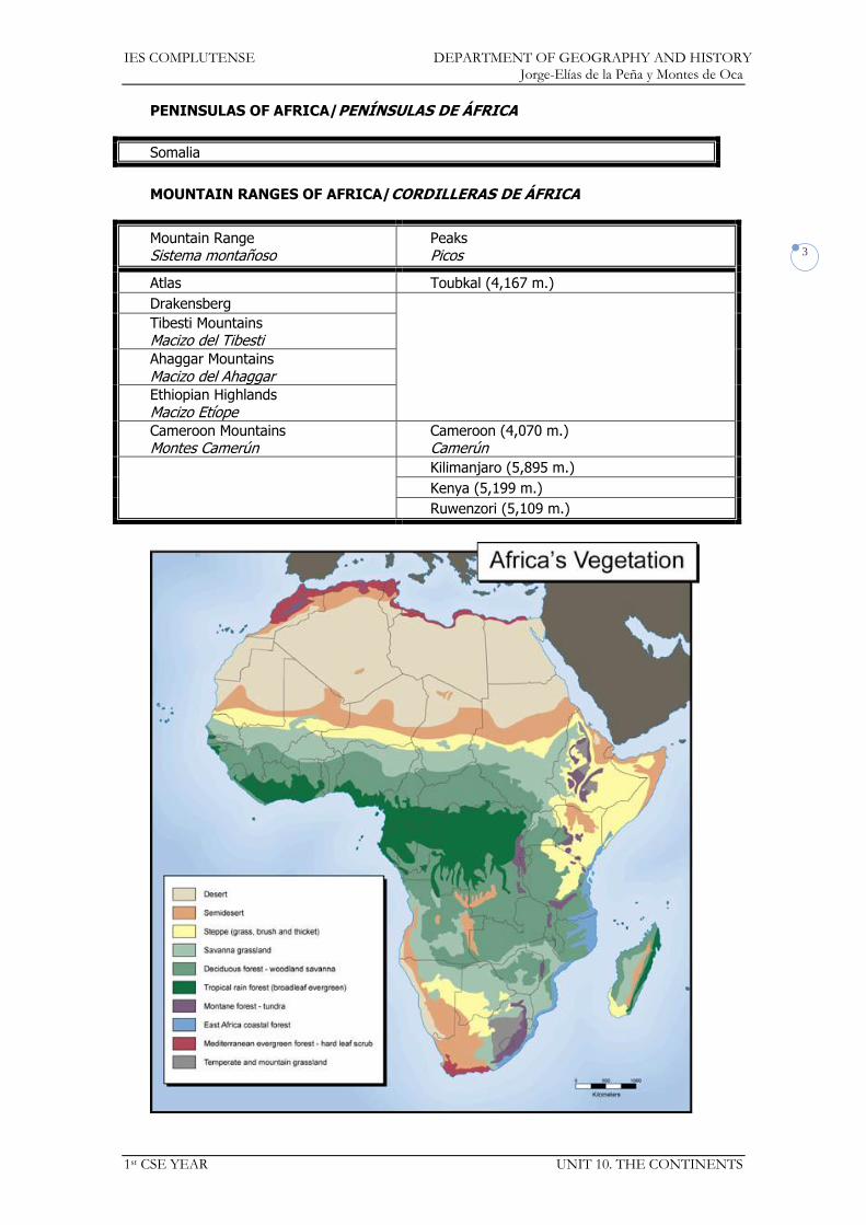
IES COMPLUTENSE DEPARTMENT OF GEOGRAPHY AND HISTORY Jorge-Elías de la Peña y Montes de Oca
1st CSE YEAR UNIT 10. THE CONTINENTS
3
PENINSULAS OF AFRICA/PENÍNSULAS DE ÁFRICA
Somalia
MOUNTAIN RANGES OF AFRICA/CORDILLERAS DE ÁFRICA
Mountain Range Sistema montañoso
Peaks Picos
Atlas Toubkal (4,167 m.)
Drakensberg
Tibesti Mountains Macizo del Tibesti Ahaggar Mountains
Macizo del Ahaggar Ethiopian Highlands
Macizo Etíope Cameroon Mountains Montes Camerún
Cameroon (4,070 m.) Camerún
Kilimanjaro (5,895 m.)
Kenya (5,199 m.)
Ruwenzori (5,109 m.)

IES COMPLUTENSE DEPARTMENT OF GEOGRAPHY AND HISTORY Jorge-Elías de la Peña y Montes de Oca
1st CSE YEAR UNIT 10. THE CONTINENTS
4
PLAINS AND PLATEAUS OF AFRICA/LLANURAS Y MESETAS DE ÁFRICA
Congo Basin Gran Cubeta del Congo
South African Plain
Meseta Sudafricana
RIVERS OF AFRICA/RÍOS DE ÁFRICA
Drainage Basin
Vertiente River
Río
Mediterranean Sea Mar Mediterráneo
Nile (6,650 km.) Nilo
Atlantic Ocean Océano Atlántico
Senegal (1,790 km.)
Niger (4,180 km.)
Níger Congo (4,700 km.) Orange (2,200 km.)
Indian Ocean Océano Índico
Limpopo (1,750 km.)
Zambezi (3,540 km.)
Zambeze
LAKES OF AFRICA/LAGOS DE ÁFRICA
Victoria Tanganyika Tanganica
Turkana Malawi
Albert
Alberto Chad
DESERTS OF AFRICA/DESIERTOS DE ÁFRICA
Sahara
Sáhara Kalahari
https://docs.google.com/open?id=0Bwe1dU-54DkeVzBuNERKSWZla1U
https://docs.google.com/open?id=0Bwe1dU-54DkeM0JuYlBPS0RtRmM

IES COMPLUTENSE DEPARTMENT OF GEOGRAPHY AND HISTORY Jorge-Elías de la Peña y Montes de Oca
1st CSE YEAR UNIT 10. THE CONTINENTS
5
COUNTRIES AND CAPITALS OF AFRICA/PAÍSES Y CAPITALES DE ÁFRICA
ALGERIA ARGELIA
Algiers Argel
MADAGASCAR Antananarivo
ANGOLA Luanda MALAWI Lilongwe
BENIN BENÍN
Porto Novo MALI MALÍ
Bamako
BOTSWANA Gaborone MAURITANIA Nouakchot Nuakchot
BURKINA FASO Ouagadougou Uagadugú
MAURITIUS MAURICIO
Port Louis
BURUNDI Bujumbura MOROCCO MARRUECOS
Rabat
CAMEROON
CAMERÚN Yaoundé
Yaundé MOZAMBIQUE Maputo
CAPE VERDE CABO VERDE
Praia NAMIBIA Windhoek
CENTRAL AFRICAN REPUBLIC REPÚBLICA CENTROAFRICANA
Bangui NIGER NÍGER
Niamey
CHAD N’Djamena N’Yamena
NIGERIA Abuja
COMOROS COMORAS
Moroni RWANDA RUANDA
Kigali
CONGO Brazzaville SÃO TOMÉ E PRÍNCIPE SANTO TOMÉ Y PRÍNCIPE
São Tomé Santo Tomé
D.R. OF THE CONGO
R.D. DEL CONGO Kinshasa SENEGAL Dakar
DJIBOUTI YIBUTI
Djibouti Yibuti
SEYCHELLES Victoria
EGYPT EGIPTO
Cairo El Cairo
SIERRA LEONA Freetown
EQUATORIAL GUINEA GUINEA ECUATORIAL
Malabo SOMALIA Mogadishu Mogadiscio
ERITREA Asmara SOUTH AFRICA REPÚBLICA SUDAFRICANA
Cape Town, Pretoria and Bloemfontein Ciudad del Cabo,...
ETHIOPIA ETIOPÍA
Addis Ababa Addís Abeba
SOUTH SUDAN SUDÁN DEL SUR
Juba
GABON GABÓN
Libreville SUDAN SUDÁN
Khartoum Jartum
THE GAMBIA GAMBIA
Banjul SWAZILAND SWAZILANDIA
Mbabane
GHANA Accra TANZANIA Dodoma
GUINEA Conakry TOGO Lomé
GUINEA BISSAU Bissau TUNISIA TUNICIA/TÚNEZ
Tunis Túnez
IVORY COAST COSTA DE MARFIL
Yamoussoukro Yamusukro
UGANDA Kampala
KENYA KENIA
Nairobi WESTERN SAHARA SÁHARA OCCIDENTAL
El Aaiún
LESOTHO Maseru ZAMBIA Lusaka
LIBERIA Monrovia
ZIMBABWE Harare LIBYA LIBIA
Tripoli Trípoli
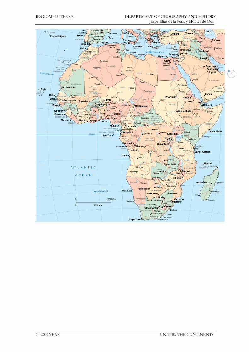
IES COMPLUTENSE DEPARTMENT OF GEOGRAPHY AND HISTORY Jorge-Elías de la Peña y Montes de Oca
1st CSE YEAR UNIT 10. THE CONTINENTS
6

IES COMPLUTENSE DEPARTMENT OF GEOGRAPHY AND HISTORY Jorge-Elías de la Peña y Montes de Oca
1st CSE YEAR UNIT 10. THE CONTINENTS
7
2. ASIA
SEAS OF ASIA/MARES DE ASIA
Arctic Ocean Océano Glacial Ártico
South China Sea Mar de la China Meridional
Bering Sea Mar de Bering
Philippine Sea Mar de Filipinas
Pacific Ocean Océano Pacífico
Indian Ocean Océano Índico
Sea of Okhotsk Mar de Ojotsk
Arabian Sea Mar Arábigo
Yellow Sea Mar Amarillo
Red Sea Mar Rojo
East China Sea
Mar de la China Oriental Mediterranean Sea
Mar Mediterráneo
Sea of Japan
Mar del Japón Black Sea
Mar Negro
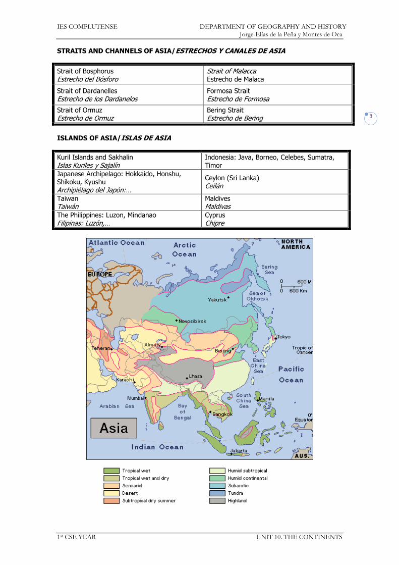
IES COMPLUTENSE DEPARTMENT OF GEOGRAPHY AND HISTORY Jorge-Elías de la Peña y Montes de Oca
1st CSE YEAR UNIT 10. THE CONTINENTS
8
STRAITS AND CHANNELS OF ASIA/ESTRECHOS Y CANALES DE ASIA
Strait of Bosphorus
Estrecho del Bósforo Strait of Malacca Estrecho de Malaca
Strait of Dardanelles
Estrecho de los Dardanelos Formosa Strait
Estrecho de Formosa
Strait of Ormuz
Estrecho de Ormuz Bering Strait
Estrecho de Bering
ISLANDS OF ASIA/ISLAS DE ASIA
Kuril Islands and Sakhalin
Islas Kuriles y Sajalín Indonesia: Java, Borneo, Celebes, Sumatra,
Timor
Japanese Archipelago: Hokkaido, Honshu, Shikoku, Kyushu
Archipiélago del Japón:…
Ceylon (Sri Lanka)
Ceilán
Taiwan Taiwán
Maldives Maldivas
The Philippines: Luzon, Mindanao
Filipinas: Luzón,… Cyprus
Chipre

IES COMPLUTENSE DEPARTMENT OF GEOGRAPHY AND HISTORY Jorge-Elías de la Peña y Montes de Oca
1st CSE YEAR UNIT 10. THE CONTINENTS
9
GULFS AND BAYS OF ASIA/GOLFOS DE ASIA
Gulf of Thailand
Golfo de Tailandia Gulf of Oman
Golfo de Omán Bay of Bengal Golfo de Bengala Gulf of Aden
Golfo de Adén Persian Gulf
Golfo Pérsico
CAPES OF ASIA/CABOS DE ASIA
Comorin Comorín
PENINSULAS OF ASIA/PENÍNSULAS DE ASIA
Anatolian peninsula Península de Anatolia
Malay peninsula Península de Malaca
Arabian peninsula Península arábiga
Korean peninsula Península de Corea
Hindustan Península del Indostán
Kamchatka Indochina
Península de Indochina
MOUNTAIN RANGES OF ASIA/CORDILLERAS DE ASIA
Mountain Range
Sistema montañoso Peaks
Picos
Himalayas
Himalaya Everest (8,848 m.)
K2 (8,611 m.)
Hindu Kush Tirich Mir (7,690 m.)
Pamir Mountains
Meseta del Pamir Ismoil Somoni/Comunism (7,495 m.)
…/Comunismo Altay Mountains
Montes Altai
Zagros Mountains Montes Zagros Caucasus
Cáucaso Yablonovy Mountains
Montes Yablonovi Stanovoiy Range Montes Stanovoi Verkhoyansk Range
Verjoyansk Ural Mountains
Urales Japanese Alps Alpes Japoneses
Fuji (3,776 m.) Fujiyama

IES COMPLUTENSE DEPARTMENT OF GEOGRAPHY AND HISTORY Jorge-Elías de la Peña y Montes de Oca
1st CSE YEAR UNIT 10. THE CONTINENTS
10
PLAINS AND PLATEAUS OF ASIA/LLANURAS Y MESETAS DE ASIA
Tibetan Plateau
Meseta del Tíbet Iranian Plateau
Meseta Iraní
Deccan Plateau
Meseta del Decán China Plain
Llanura de China
Indo-Gangetic Plain
Llanura Indo-Gangética West Siberian Plain
Llanura de Siberia occidental
RIVERS OF ASIA/RÍOS DE ASIA
Drainage Basin
Vertiente River
Río
Arctic Ocean Océano Glacial Ártico
Yenisey (4,090 km.) Yeniséi
Ob (2,962 km.)
Obi Lena (4,472 km.)
Kolyma (2,129 km.)
Kolima
Pacific Ocean
Océano Pacífico
Amur (2,824 km.)
Huang He/Yellow (5,464 km.) Huang Ho/Amarillo
Yangtze Kiang/Blue (6,300 km.) Yangtsé Kiang/Azul Sikiang/Black (1,930 km.)
Sikiang/Negro Mekong (4,909 km.)
Indian Ocean
Océano Índico
Brahmaputra (2,900 km.)
Ganges (2,510 km.)
Indus (3,100 km.) Indo
Tigris (1,850 km.)
Euphrates (2,850 km.)
Éufrates
Aral Sea
Mar de Aral
Amu Darya (2,400 km.) Amu Daria Syr Darya (2,212 km.)
Sir Daria
LAKES OF ASIA/LAGOS DE ASIA
Caspian Sea
Mar Caspio Lake Baikal
Lago Baikal Aral Sea Mar de Aral
Lake Balkhash Lago Baljash
DESERTS OF ASIA/DESIERTOS DE ASIA
Gobi Desert
Desierto del Gobi Arabian Desert
Desierto de Arabia
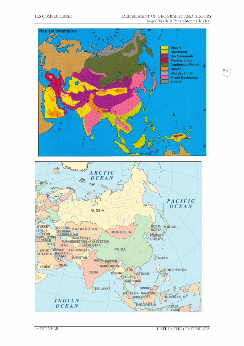
IES COMPLUTENSE DEPARTMENT OF GEOGRAPHY AND HISTORY Jorge-Elías de la Peña y Montes de Oca
1st CSE YEAR UNIT 10. THE CONTINENTS
11
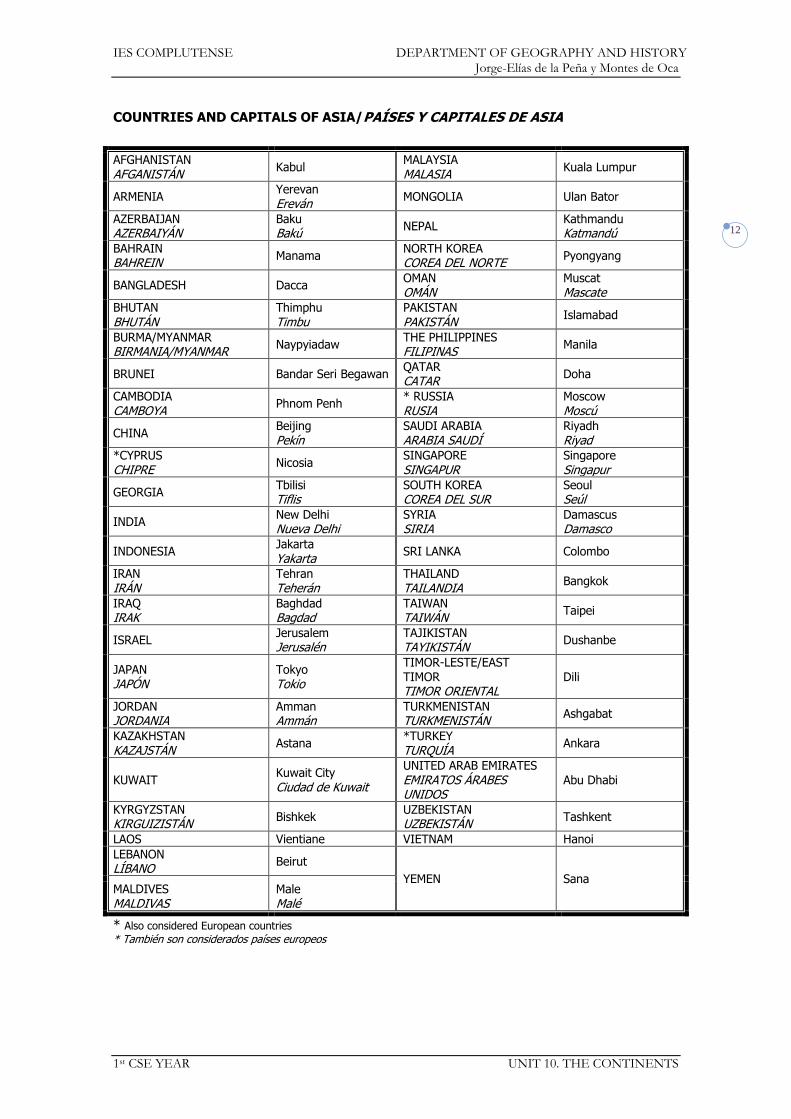
IES COMPLUTENSE DEPARTMENT OF GEOGRAPHY AND HISTORY Jorge-Elías de la Peña y Montes de Oca
1st CSE YEAR UNIT 10. THE CONTINENTS
12
COUNTRIES AND CAPITALS OF ASIA/PAÍSES Y CAPITALES DE ASIA
AFGHANISTAN AFGANISTÁN
Kabul MALAYSIA MALASIA
Kuala Lumpur
ARMENIA Yerevan Ereván
MONGOLIA Ulan Bator
AZERBAIJAN AZERBAIYÁN
Baku Bakú
NEPAL Kathmandu Katmandú
BAHRAIN BAHREIN
Manama NORTH KOREA COREA DEL NORTE
Pyongyang
BANGLADESH Dacca OMAN OMÁN
Muscat Mascate
BHUTAN
BHUTÁN Thimphu
Timbu PAKISTAN
PAKISTÁN Islamabad
BURMA/MYANMAR BIRMANIA/MYANMAR
Naypyiadaw THE PHILIPPINES FILIPINAS
Manila
BRUNEI Bandar Seri Begawan QATAR CATAR
Doha
CAMBODIA CAMBOYA
Phnom Penh * RUSSIA RUSIA
Moscow Moscú
CHINA Beijing Pekín
SAUDI ARABIA ARABIA SAUDÍ
Riyadh Riyad
*CYPRUS CHIPRE
Nicosia SINGAPORE SINGAPUR
Singapore Singapur
GEORGIA Tbilisi Tiflis
SOUTH KOREA COREA DEL SUR
Seoul Seúl
INDIA New Delhi Nueva Delhi
SYRIA SIRIA
Damascus Damasco
INDONESIA Jakarta Yakarta
SRI LANKA Colombo
IRAN IRÁN
Tehran Teherán
THAILAND TAILANDIA
Bangkok
IRAQ IRAK
Baghdad Bagdad
TAIWAN TAIWÁN
Taipei
ISRAEL Jerusalem Jerusalén
TAJIKISTAN TAYIKISTÁN
Dushanbe
JAPAN JAPÓN
Tokyo Tokio
TIMOR-LESTE/EAST TIMOR TIMOR ORIENTAL
Dili
JORDAN JORDANIA
Amman Ammán
TURKMENISTAN TURKMENISTÁN
Ashgabat
KAZAKHSTAN
KAZAJSTÁN Astana
*TURKEY
TURQUÍA Ankara
KUWAIT Kuwait City Ciudad de Kuwait
UNITED ARAB EMIRATES EMIRATOS ÁRABES UNIDOS
Abu Dhabi
KYRGYZSTAN KIRGUIZISTÁN
Bishkek UZBEKISTAN UZBEKISTÁN
Tashkent
LAOS Vientiane VIETNAM Hanoi
LEBANON LÍBANO
Beirut
YEMEN Sana MALDIVES MALDIVAS
Male Malé
* Also considered European countries
* También son considerados países europeos

IES COMPLUTENSE DEPARTMENT OF GEOGRAPHY AND HISTORY Jorge-Elías de la Peña y Montes de Oca
1st CSE YEAR UNIT 10. THE CONTINENTS
13
3. AMERICA
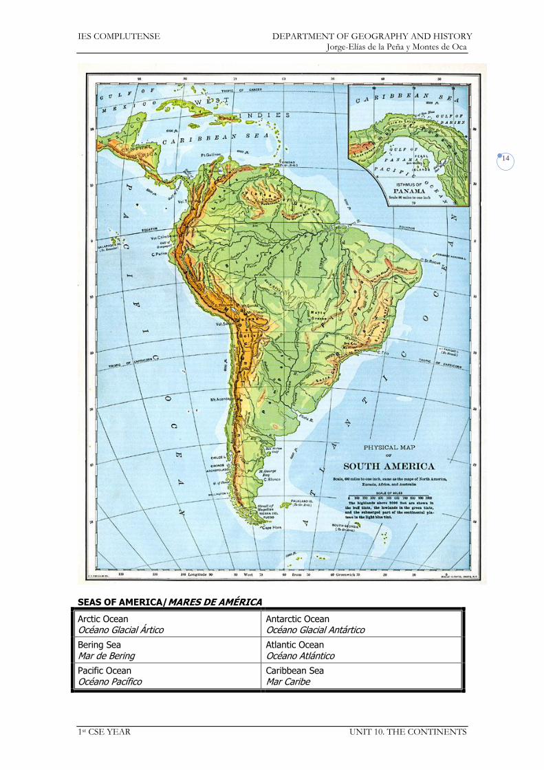
IES COMPLUTENSE DEPARTMENT OF GEOGRAPHY AND HISTORY Jorge-Elías de la Peña y Montes de Oca
1st CSE YEAR UNIT 10. THE CONTINENTS
14
SEAS OF AMERICA/MARES DE AMÉRICA
Arctic Ocean Océano Glacial Ártico
Antarctic Ocean Océano Glacial Antártico
Bering Sea
Mar de Bering Atlantic Ocean
Océano Atlántico
Pacific Ocean
Océano Pacífico Caribbean Sea
Mar Caribe

IES COMPLUTENSE DEPARTMENT OF GEOGRAPHY AND HISTORY Jorge-Elías de la Peña y Montes de Oca
1st CSE YEAR UNIT 10. THE CONTINENTS
15
STRAITS AND CHANNELS OF AMERICA/ESTRECHOS Y CANALES DE AMÉRICA
Bering Strait Estrecho de Bering
Strait of Magellan Estrecho de Magallanes
ISLANDS OF AMERICA/ISLAS DE AMÉRICA
Greenland Groenlandia
Puerto Rico
Baffin Lesser Antilles
Pequeñas Antillas Newfoundland
Terranova Falkland Islands
Islas Malvinas
Cuba Tierra del Fuego
Hispaniola
La Española Galapagos Islands
Islas Galápagos
Jamaica Aleutian Islands
Islas Aleutianas

IES COMPLUTENSE DEPARTMENT OF GEOGRAPHY AND HISTORY Jorge-Elías de la Peña y Montes de Oca
1st CSE YEAR UNIT 10. THE CONTINENTS
16
GULFS AND BAYS OF AMERICA/GOLFOS DE AMÉRICA
Baffin Bay
Bahía de Baffin Gulf of California
Golfo de California Hudson Bay
Bahía de Hudson Gulf of Alaska Golfo de Alaska Gulf of Mexico
Golfo de México

IES COMPLUTENSE DEPARTMENT OF GEOGRAPHY AND HISTORY Jorge-Elías de la Peña y Montes de Oca
1st CSE YEAR UNIT 10. THE CONTINENTS
17
CAPES OF AMERICA/CABOS DE AMÉRICA
Horn
Hornos São Roque
San Roque
São Tomé Santo Tomé
San Lucas
PENINSULAS OF AMERICA/PENÍNSULAS DE AMÉRICA
Alaska Florida
California Labrador
Yucatán
MOUNTAIN RANGES OF AMERICA/CORDILLERAS DE AMÉRICA
Mountain Range
Sistema montañoso Peaks
Picos
Andes
Aconcagua (6,962 m.)
Ojos del Salado (6,891 m.)
Huascarán (6,768 m.) Chimborazo (6,267 m.)
Guiana Highlands
Macizo de las Guayanas
Sierra Madre del Sur
Sierra Madre Oriental Orizaba (5,747 m.) Popocatepetl (5,500 m.)
Sierra Madre Occidental
Rocky Mountains
Montañas Rocosas McKinley (6,194 m.)
Appalachian Mountains
Montes Apalaches
Sierra Nevada Whitney (4,418 m.)
https://docs.google.com/open?id=0Bwe1dU-54DkedUptS2RTODlUS28
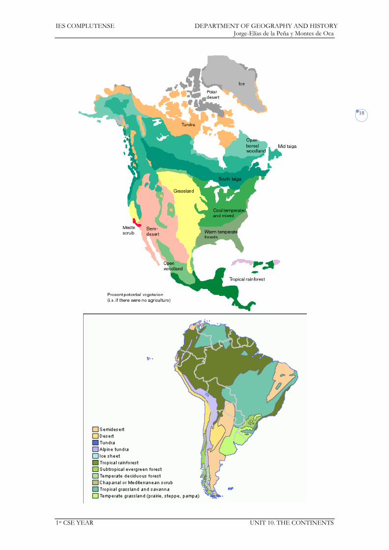
IES COMPLUTENSE DEPARTMENT OF GEOGRAPHY AND HISTORY Jorge-Elías de la Peña y Montes de Oca
1st CSE YEAR UNIT 10. THE CONTINENTS
18

IES COMPLUTENSE DEPARTMENT OF GEOGRAPHY AND HISTORY Jorge-Elías de la Peña y Montes de Oca
1st CSE YEAR UNIT 10. THE CONTINENTS
19
PLAINS AND PLATEAUS OF AMERICA/LLANURAS Y MESETAS DE AMÉRICA
Altiplano (Bolivian Plateau)
Altiplano de Bolivia Pampa
Mato Grosso Plateau
Meseta del Mato Grosso Great North American Plains
Grandes Llanuras Norteamericanas Amazon Plains Llanuras del Amazonas
RIVERS OF AMERICA/RÍOS DE AMÉRICA
Drainage Basin
Vertiente River
Río
Atlantic Ocean Océano Índico
Amazon (6,800 km.)
Amazonas
Orinoco (2,140 km.)
River Plate: Paraguay (2,621 km.), Paraná (4,880
km.), Uruguay (1,600 km.) Río de la Plata:…
Mississippi (3,764 km.)-Missouri (3,767 km.)
Misisispi-Misuri
Saint Lawrence (1,197 km.)
San Lorenzo
Pacific Ocean Océano Pacífico
Colorado (2,334 km.)
Yukon (1,984 km.) Yukón
Arctic Ocean Océano Glacial Ártico
Mackenzie (1,738 km.)
LAKES OF AMERICA /LAGOS DE AMÉRICA
Great Bear Lake Gran Lago del Oso
Great Lakes: Superior, Michigan, Huron, Erie,
Ontario
Grandes Lagos: …, Hurón,…
Great Slave Lake Gran Lago del Esclavo Lake Titicaca
Lago Titicaca Lake Winnipeg
Lago Winnipeg
DESERTS OF AMERICA/DESIERTOS DE AMÉRICA
Atacama Desert Desierto de Atacama Mojave Desert
Desierto de Mojave Sonora Desert
Desierto de Sonora

IES COMPLUTENSE DEPARTMENT OF GEOGRAPHY AND HISTORY Jorge-Elías de la Peña y Montes de Oca
1st CSE YEAR UNIT 10. THE CONTINENTS
20

IES COMPLUTENSE DEPARTMENT OF GEOGRAPHY AND HISTORY Jorge-Elías de la Peña y Montes de Oca
1st CSE YEAR UNIT 10. THE CONTINENTS
21
COUNTRIES AND CAPITALS OF AMERICA/PAÍSES Y CAPITALES DE AMÉRICA
ANTIGUA AND BARBUDA ANTIGUA Y BARBUDA
Saint John’s GUYANA Georgetown
ARGENTINA Buenos Aires HAITI HAITÍ
Port-au-Prince Puerto Príncipe
BAHAMAS Nassau HONDURAS Tegucigalpa
BARBADOS Bridgetown JAMAICA Kingston
BELIZE BELICE
Belmopan MEXICO MÉXICO
Mexico City México D.F.
BOLIVIA La Paz and Sucre NICARAGUA Managua
BRAZIL BRASIL
Brasilia PANAMA PANAMÁ
Panamá
CANADA CANADÁ
Ottawa PARAGUAY Asunción
CHILE Santiago de Chile PERU PERÚ
Lima
COLOMBIA Bogotá PUERTO RICO San Juan
COSTA RICA San José ST. KITTS AND NEVIS SAN CRISTÓBAL Y NIEVES
Basseterre
CUBA Havana La Habana
SAINT LUCIA SANTA LUCÍA
Castries
DOMINICA Roseau
ST. VINCENT AND THE GRENADINES SAN VICENTE Y LAS GRANADINAS
Kingstown
DOMINICAN REPUBLIC REPÚBLICA DOMINICANA
Santo Domingo SURINAME SURINAM
Paramaribo
ECUADOR Quito TRINIDAD AND TOBAGO TRINIDAD Y TOBAGO
Port of Spain Puerto España
EL SALVADOR San Salvador UNITED STATES ESTADOS UNIDOS
Washington D.C.
FRENCH GUIANA GUAYANA FRANCESA
Cayenne Cayena
URUGUAY Montevideo
GRENADA GRANADA
Saint George’s VENEZUELA Caracas
GUATEMALA Guatemala

IES COMPLUTENSE DEPARTMENT OF GEOGRAPHY AND HISTORY Jorge-Elías de la Peña y Montes de Oca
1st CSE YEAR UNIT 10. THE CONTINENTS
22
4. OCEANIA
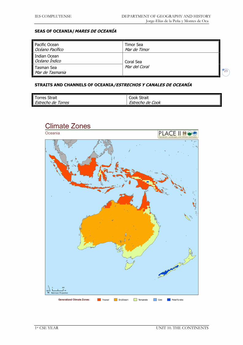
IES COMPLUTENSE DEPARTMENT OF GEOGRAPHY AND HISTORY Jorge-Elías de la Peña y Montes de Oca
1st CSE YEAR UNIT 10. THE CONTINENTS
23
SEAS OF OCEANIA/MARES DE OCEANÍA
Pacific Ocean
Océano Pacífico Timor Sea
Mar de Timor
Indian Ocean Océano Índico Coral Sea
Mar del Coral Tasman Sea Mar de Tasmania
STRAITS AND CHANNELS OF OCEANIA/ESTRECHOS Y CANALES DE OCEANÍA
Torres Strait Estrecho de Torres
Cook Strait Estrecho de Cook

IES COMPLUTENSE DEPARTMENT OF GEOGRAPHY AND HISTORY Jorge-Elías de la Peña y Montes de Oca
1st CSE YEAR UNIT 10. THE CONTINENTS
24
ISLANDS AND ARCHIPELAGOS OF OCEANIA/ISLAS Y ARCHIPIÉLAGOS DE OCEANÍA
Australia
Melanesia: Solomon Islands, Bismarck
Archipelago, New Caledonia, Fiji, Vanuatu Melanesia: Islas Salomón, Archipiélago de Bismarck, Nueva Caledonia, Fiyi,…
Tasmania
Micronesia: Marshall Islands, Caroline Islands, Mariana Islands, Guam, Palau, Kiribati
Micronesia: Islas Marshall, Islas Carolinas, Islas Marianas,…
New Zealand: North Island, South Island
Nueva Zelanda: Isla del Norte, Isla del Sur Polinesia: Hawaiian Islands, Tuvalu, Samoa,
Tonga, Cook Islands, French Polinesia, Easter
Island Polinesia: Hawai,…, Islas Cook, Polinesia Francesa, Isla de Pascua
New Guinea Nueva Guinea
GULFS AND BAYS OF OCEANIA/GOLFOS DE OCEANÍA
Island Isla
Gulf or Bay Golfo
Australia
Great Australian Bight
Gran Bahía Australiana
Gulf of Carpentaria
Golfo de Carpentaria

IES COMPLUTENSE DEPARTMENT OF GEOGRAPHY AND HISTORY Jorge-Elías de la Peña y Montes de Oca
1st CSE YEAR UNIT 10. THE CONTINENTS
25
CAPES OF OCEANIA /CABOS DE OCEANÍA
Island
Isla Cape
Cabo
Australia York
PENINSULAS OF OCEANIA/PENÍNSULAS DE OCEANÍA
Island
Isla Peninsula
Península
Australia Cape York Peninsula (Australia)
Península del Cabo York (Australia)
MOUNTAIN RANGES OF OCEANIA/CORDILLERAS DE OCEANÍA
Island Isla
Mountain Range Sistema montañoso
Peaks Picos
Australia Great Dividing Range
Gran Cordillera Divisoria Kosciusko (2,228 m.)
New Zealand Southern Alps Alpes Neozelandeses
Cook (3,764 m.)
RIVERS OF OCEANIA/RÍOS DE OCEANÍA
Island
Isla Drainage Basin
Vertiente River
Río
Australia Indian Ocean
Océano Pacífico Murray (2,375 km.)-Darling (1,472
km.)
DESERTS OF OCEANIA/DESIERTOS DE OCEANÍA
Island
Isla Desert
Desierto
Australia
Great Sandy Desert
Gran Desierto de Arena
Great Victoria Desert Gran Desierto Victoria Simpson Desert
Desierto Simpson Gibson Desert
Desierto Gibson
https://docs.google.com/open?id=0Bwe1dU-54Dkea1lOXzg5TWFRWDg

IES COMPLUTENSE DEPARTMENT OF GEOGRAPHY AND HISTORY Jorge-Elías de la Peña y Montes de Oca
1st CSE YEAR UNIT 10. THE CONTINENTS
26
COUNTRIES AND CAPITALS OF OCEANIA/PAÍSES Y CAPITALES DE OCEANÍA
AUSTRALIA Canberra PALAU Melekeok
FIJI FIYI
Suva PAPUA NEW GUINEA PAPÚA NUEVA GUINEA
Port Moresby
KIRIBATI Tarawa SOLOMON ISLANDS ISLAS SALOMÓN
Honiara
MARSHALL ISLANDS ISLAS MARSHALL
Majuro TONGA Nuku’alofa
MICRONESIA Palikir TUVALU Funafuti
NAURU Yaren VANUATU Port Vila
NEW ZEALAND NUEVA ZELANDA
Wellington WESTERN SAMOA SAMOA OCCIDENTAL
Apia
IES COMPLUTENSE DEPARTMENT OF GEOGRAPHY AND HISTORY Jorge-Elías de la Peña y Montes de Oca
1st CSE YEAR UNIT 11. EUROPE AND SPAIN
1
Social Science 1st CSE
UNIT 11: Europe and Spain
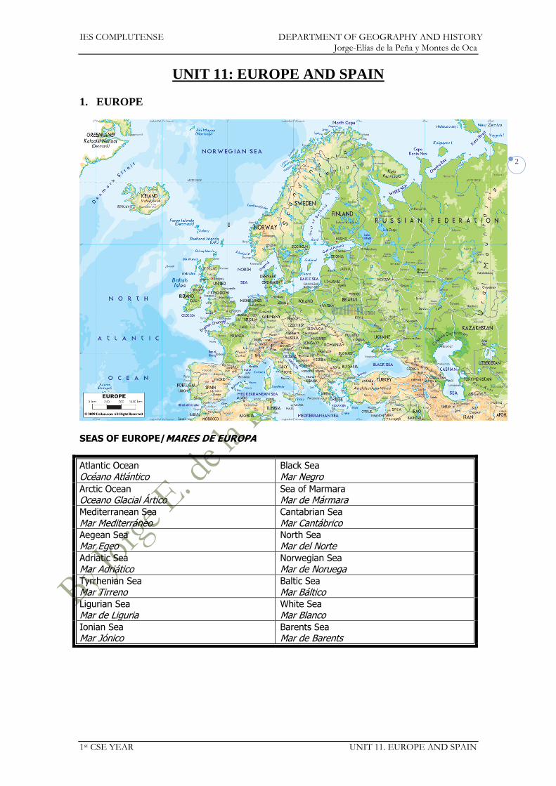
IES COMPLUTENSE DEPARTMENT OF GEOGRAPHY AND HISTORY Jorge-Elías de la Peña y Montes de Oca
1st CSE YEAR UNIT 11. EUROPE AND SPAIN
2
UNIT 11: EUROPE AND SPAIN
1. EUROPE
SEAS OF EUROPE/MARES DE EUROPA
Atlantic Ocean
Océano Atlántico Black Sea
Mar Negro
Arctic Ocean Oceano Glacial Ártico
Sea of Marmara Mar de Mármara
Mediterranean Sea
Mar Mediterráneo Cantabrian Sea
Mar Cantábrico Aegean Sea
Mar Egeo North Sea
Mar del Norte Adriatic Sea Mar Adriático
Norwegian Sea Mar de Noruega
Tyrrhenian Sea
Mar Tirreno Baltic Sea
Mar Báltico
Ligurian Sea
Mar de Liguria White Sea
Mar Blanco Ionian Sea Mar Jónico
Barents Sea Mar de Barents
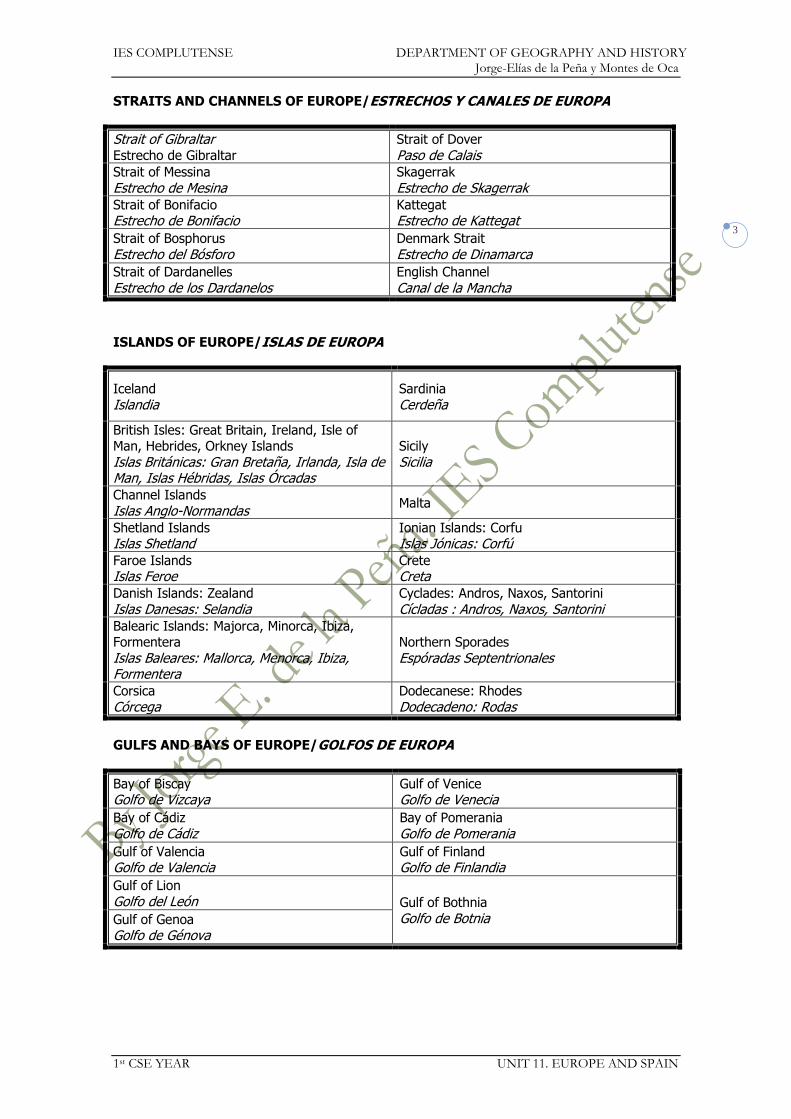
IES COMPLUTENSE DEPARTMENT OF GEOGRAPHY AND HISTORY Jorge-Elías de la Peña y Montes de Oca
1st CSE YEAR UNIT 11. EUROPE AND SPAIN
3
STRAITS AND CHANNELS OF EUROPE/ESTRECHOS Y CANALES DE EUROPA
Strait of Gibraltar Estrecho de Gibraltar
Strait of Dover
Paso de Calais Strait of Messina
Estrecho de Mesina Skagerrak
Estrecho de Skagerrak Strait of Bonifacio Estrecho de Bonifacio
Kattegat Estrecho de Kattegat
Strait of Bosphorus
Estrecho del Bósforo Denmark Strait
Estrecho de Dinamarca
Strait of Dardanelles
Estrecho de los Dardanelos English Channel
Canal de la Mancha
ISLANDS OF EUROPE/ISLAS DE EUROPA
Iceland
Islandia Sardinia
Cerdeña
British Isles: Great Britain, Ireland, Isle of Man, Hebrides, Orkney Islands
Islas Británicas: Gran Bretaña, Irlanda, Isla de Man, Islas Hébridas, Islas Órcadas
Sicily
Sicilia
Channel Islands
Islas Anglo-Normandas Malta
Shetland Islands Islas Shetland
Ionian Islands: Corfu Islas Jónicas: Corfú
Faroe Islands Islas Feroe
Crete Creta
Danish Islands: Zealand
Islas Danesas: Selandia Cyclades: Andros, Naxos, Santorini
Cícladas : Andros, Naxos, Santorini Balearic Islands: Majorca, Minorca, Ibiza, Formentera
Islas Baleares: Mallorca, Menorca, Ibiza, Formentera
Northern Sporades
Espóradas Septentrionales
Corsica
Córcega Dodecanese: Rhodes
Dodecadeno: Rodas
GULFS AND BAYS OF EUROPE/GOLFOS DE EUROPA
Bay of Biscay Golfo de Vizcaya
Gulf of Venice Golfo de Venecia
Bay of Cádiz
Golfo de Cádiz Bay of Pomerania
Golfo de Pomerania
Gulf of Valencia Golfo de Valencia
Gulf of Finland Golfo de Finlandia
Gulf of Lion
Golfo del León Gulf of Bothnia
Golfo de Botnia Gulf of Genoa Golfo de Génova
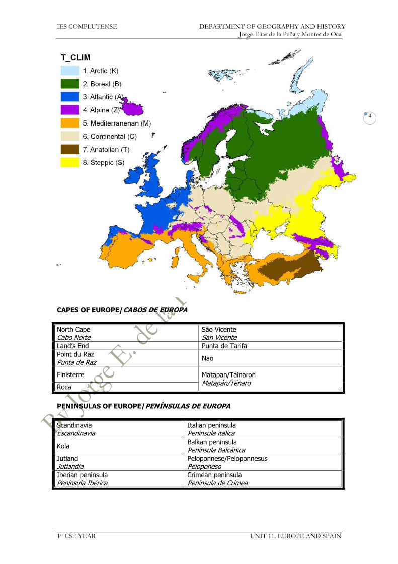
IES COMPLUTENSE DEPARTMENT OF GEOGRAPHY AND HISTORY Jorge-Elías de la Peña y Montes de Oca
1st CSE YEAR UNIT 11. EUROPE AND SPAIN
4
CAPES OF EUROPE/CABOS DE EUROPA
North Cape Cabo Norte
São Vicente San Vicente
Land’s End Punta de Tarifa
Point du Raz
Punta de Raz Nao
Finisterre Matapan/Tainaron
Matapán/Ténaro Roca
PENINSULAS OF EUROPE/PENÍNSULAS DE EUROPA
Scandinavia Escandinavia
Italian peninsula Peninsula italica
Kola Balkan peninsula
Península Balcánica Jutland Jutlandia
Peloponnese/Peloponnesus Peloponeso
Iberian peninsula
Península Ibérica Crimean peninsula
Península de Crimea
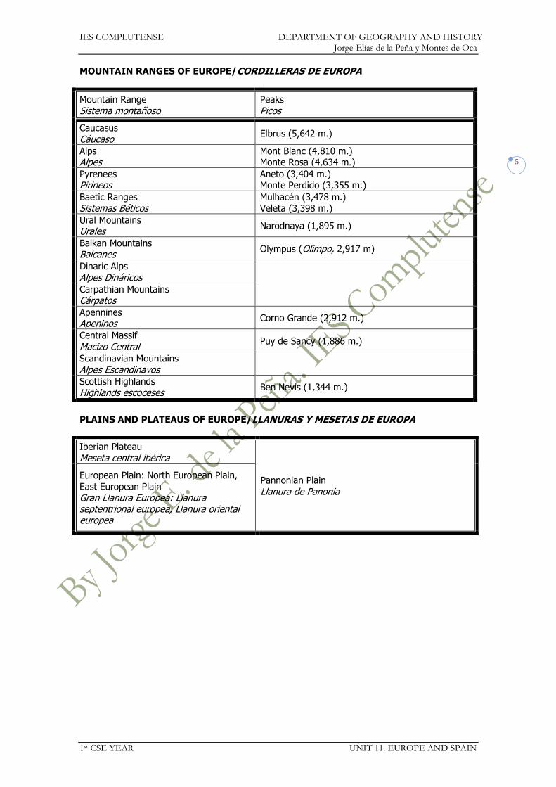
IES COMPLUTENSE DEPARTMENT OF GEOGRAPHY AND HISTORY Jorge-Elías de la Peña y Montes de Oca
1st CSE YEAR UNIT 11. EUROPE AND SPAIN
5
MOUNTAIN RANGES OF EUROPE/CORDILLERAS DE EUROPA
Mountain Range
Sistema montañoso Peaks
Picos
Caucasus
Cáucaso Elbrus (5,642 m.)
Alps Alpes
Mont Blanc (4,810 m.) Monte Rosa (4,634 m.)
Pyrenees Pirineos
Aneto (3,404 m.) Monte Perdido (3,355 m.)
Baetic Ranges
Sistemas Béticos Mulhacén (3,478 m.)
Veleta (3,398 m.)
Ural Mountains Urales
Narodnaya (1,895 m.)
Balkan Mountains Balcanes
Olympus (Olimpo, 2,917 m)
Dinaric Alps
Alpes Dináricos
Carpathian Mountains Cárpatos Apennines Apeninos
Corno Grande (2,912 m.)
Central Massif
Macizo Central Puy de Sancy (1,886 m.)
Scandinavian Mountains Alpes Escandinavos
Scottish Highlands Highlands escoceses
Ben Nevis (1,344 m.)
PLAINS AND PLATEAUS OF EUROPE/LLANURAS Y MESETAS DE EUROPA
Iberian Plateau
Meseta central ibérica
Pannonian Plain
Llanura de Panonia
European Plain: North European Plain,
East European Plain Gran Llanura Europea: Llanura septentrional europea, Llanura oriental europea

IES COMPLUTENSE DEPARTMENT OF GEOGRAPHY AND HISTORY Jorge-Elías de la Peña y Montes de Oca
1st CSE YEAR UNIT 11. EUROPE AND SPAIN
6
RIVERS OF EUROPE/RÍOS DE EUROPA
Drainage Basin Vertiente
River Río
Caspian Sea
Mar Caspio Volga (3,690 km)
Ural (2,428 km.)
Black Sea Mar Negro
Danube (2,860 km.)
Danubio Dnieper (2,290 km.) Dniéper Dniester (1,352 km.) Dniéster Don (1,950 km.)
Mediterranean Sea
Mar Mediterráneo
Ebro (960 km)
Rhone (815 km.)
Ródano Po (682 km.)
Atlantic Ocean Océano Atlántico
Elbe (1,091 km.)
Elba Rhine (1,236 km.) Rin Seine (776 km.)
Sena Loire (1,012 km.)
Loira Garonne (575 km.) Garona Duero (897 km)
Tagus (1,038 km.) Tajo Guadiana (818 km.)
Guadalquivir (657 km.)
Thames (346 km.) Támesis
Baltic Sea Mar Báltico
Oder (854 km.)
Vistula (1,047 km.)
Vístula
Arctic Ocean
Océano Glacial Ártico
Northern Dvina (744 km.) Dvina Septentrional
Pechora (1,809 km.)
LAKES OF EUROPE/LAGOS DE EUROPA
Caspian Sea
Mar Caspio Lake Onega
Lago Onega Lake Ladoga Lago Ladoga
Lake Geneva/Léman Lago de Ginebra/Lemán
https://docs.google.com/open?id=0Bwe1dU-54DkeNmw3NGhSRDVUUVk

IES COMPLUTENSE DEPARTMENT OF GEOGRAPHY AND HISTORY Jorge-Elías de la Peña y Montes de Oca
1st CSE YEAR UNIT 11. EUROPE AND SPAIN
7
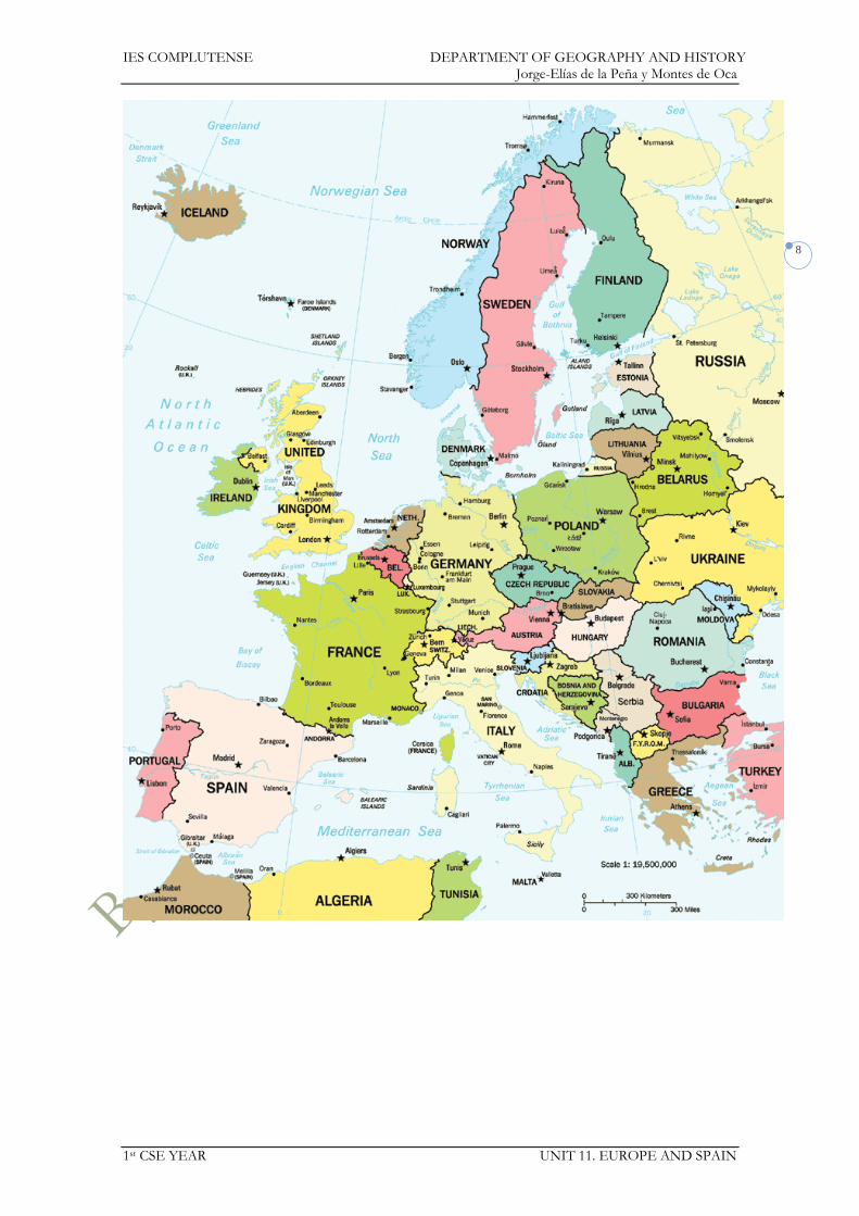
IES COMPLUTENSE DEPARTMENT OF GEOGRAPHY AND HISTORY Jorge-Elías de la Peña y Montes de Oca
1st CSE YEAR UNIT 11. EUROPE AND SPAIN
8

IES COMPLUTENSE DEPARTMENT OF GEOGRAPHY AND HISTORY Jorge-Elías de la Peña y Montes de Oca
1st CSE YEAR UNIT 11. EUROPE AND SPAIN
9
COUNTRIES AND CAPITALS OF EUROPE/PAÍSES Y CAPITALES DE EUROPA
ALBANIA Tirana LUXEMBOURG LUXEMBURGO
Luxembourg Luxemburgo
ANDORRA Andorra la Vella Andorra la Vieja/Vella
F.Y.R. OF MACEDONIA MACEDONIA
Skopje
AUSTRIA Vienna Viena
MALTA Valletta La Valeta
BELGIUM BÉLGICA
Brussels Bruselas
MOLDOVA MOLDAVIA
Chisinau
BELARUS BIELORRUSIA
Minsk MONACO MÓNACO
Monaco Mónaco
BOSNIA HERZEGOVINA Sarajevo MONTENEGRO Podgorica
BULGARIA Sofia Sofía
THE NETHERLANDS/ HOLLAND PAÍSES BAJOS/HOLANDA
The Hague and Amsterdam La Haya y Ámsterdam
CZECH REPUBLIC CHEQUIA/REPÚBLICA CHECA
Prague Praga
NORWAY NORUEGA
Oslo
CROATIA CROACIA
Zagreb POLAND POLONIA
Warsaw Varsovia
CYPRUS CHIPRE
Nicosia PORTUGAL Lisbon Lisboa
DENMARK DINAMARCA
Copenhagen Copenhague
ROMANIA RUMANÍA
Bucharest Bucarest
GERMANY ALEMANIA
Berlin Berlín
RUSSIA RUSIA
Moscow Moscú
ESTONIA Tallinn
Tallín SAN MARINO San Marino
FINLAND FINLANDIA
Helsinki SERBIA Belgrade Belgrado
FRANCE FRANCIA
Paris París
SLOVAKIA ESLOVAQUIA
Bratislava
GREECE GRECIA
Athens Atenas
SLOVENIA ESLOVENIA
Ljubljana Liubliana
HUNGARY HUNGRÍA
Budapest SPAIN ESPAÑA
Madrid
ICELAND ISLANDIA
Reykjavik Reikiavik
SWEDEN SUECIA
Stockholm Estocolmo
IRELAND IRLANDA
Dublin Dublín
SWITZERLAND SUIZA
Bern Berna
ITALY ITALIA
Rome Roma
TURKEY TURQUÍA
Ankara
LATVIA LETONIA
Riga UNITED KINGDOM REINO UNIDO
London Londres
LIECHTENSTEIN Vaduz UKRAINE UCRACIA
Kiev/Kyiv Kiev
LITHUANIA LITUANIA
Vilnius Vilnius/Vilna
VATICAN CITY/HOLY SEE VATICANO/SANTA SEDE
Vatican City Ciudad del Vaticano
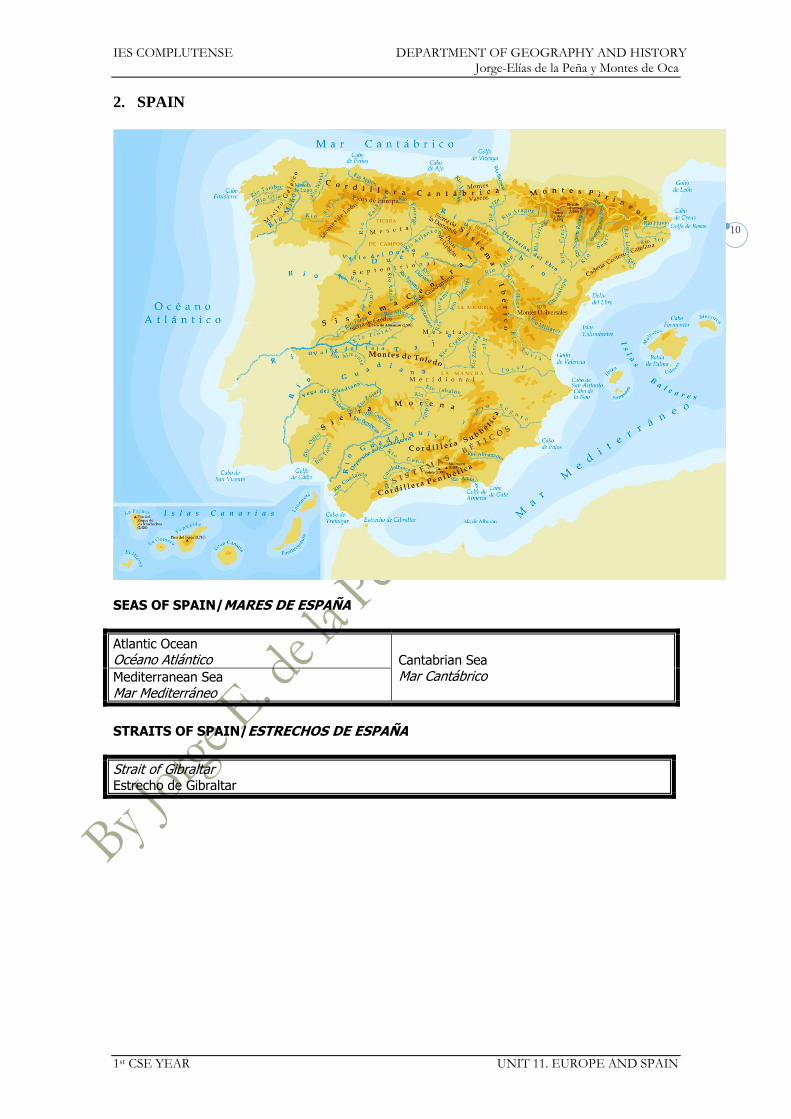
IES COMPLUTENSE DEPARTMENT OF GEOGRAPHY AND HISTORY Jorge-Elías de la Peña y Montes de Oca
1st CSE YEAR UNIT 11. EUROPE AND SPAIN
10
2. SPAIN
SEAS OF SPAIN/MARES DE ESPAÑA
Atlantic Ocean Océano Atlántico Cantabrian Sea
Mar Cantábrico Mediterranean Sea
Mar Mediterráneo
STRAITS OF SPAIN/ESTRECHOS DE ESPAÑA
Strait of Gibraltar Estrecho de Gibraltar
IES COMPLUTENSE DEPARTMENT OF GEOGRAPHY AND HISTORY Jorge-Elías de la Peña y Montes de Oca
1st CSE YEAR UNIT 11. EUROPE AND SPAIN
11
ISLANDS OF SPAIN/ISLAS DE ESPAÑA
Balearic Islands: Majorca, Minorca, Ibiza,
Formentera, Cabrera Islas Baleares: Mallorca, Menorca, Ibiza, Formentera, Cabrera
Medas
Canary Islands: Tenerife, La Gomera, La Palma, El Hierro, Gran Canaria,
Fuerteventura, Lanzarote Islas Canarias:…
Columbretes
North African Islands: Chafarinas Islands,
Peñón de Alhucemas, Peñón de Vélez de la Gomera, Perejil
Islas norteafricanas: Islas Chafarinas,…
Galician Atlantic Islands: Cíes, Sálvora, Ons
Islas atlánticas gallegas: Cíes,…
Alborán
GULFS AND BAYS OF SPAIN/GOLFOS DE SPAIN
Gulf of Rosas Golfo de Rosas
Gulf of Mazarrón Golfo de Mazarrón
Gulf of San Jorge
Golfo de San Jorge Gulf of Almería Golfo de Almería
Gulf of Valencia Golfo de Valencia
Bay of Cádiz Golfo de Cádiz
Gulf of Alicante
Golfo de Alicante Bay of Biscay
Golfo de Vizcaya
CAPES OF SPAIN/CABOS DE ESPAÑA
Creus San Vicente
San Jorge Roca
San Antonio Finisterre
Nao Punta de Estaca de Bares
Palos Ortegal
Gata Peñas
Sacratif Ajo
Punta de Tarifa Machichaco
Trafalgar
PLAINS AND PLATEAUS OF SPAIN/LLANURAS Y MESETAS DE ESPAÑA
Iberian Plateau Meseta Central: Submeseta norte o septentrional, Submeseta sur o meridional.
DEPRESSIONS OF SPAIN/DEPRESIONES DE ESPAÑA
Guadalquivir Ebro
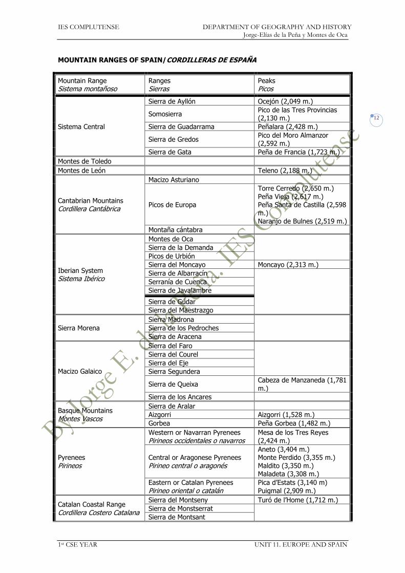
IES COMPLUTENSE DEPARTMENT OF GEOGRAPHY AND HISTORY Jorge-Elías de la Peña y Montes de Oca
1st CSE YEAR UNIT 11. EUROPE AND SPAIN
12
MOUNTAIN RANGES OF SPAIN/CORDILLERAS DE ESPAÑA
Mountain Range Sistema montañoso
Ranges Sierras
Peaks Picos
Sistema Central
Sierra de Ayllón Ocejón (2,049 m.)
Somosierra Pico de las Tres Provincias (2,130 m.)
Sierra de Guadarrama Peñalara (2,428 m.)
Sierra de Gredos Pico del Moro Almanzor (2,592 m.)
Sierra de Gata Peña de Francia (1,723 m.)
Montes de Toledo
Montes de León Teleno (2,188 m.)
Cantabrian Mountains Cordillera Cantábrica
Macizo Asturiano
Picos de Europa
Torre Cerredo (2,650 m.)
Peña Vieja (2,617 m.) Peña Santa de Castilla (2,598
m.) Naranjo de Bulnes (2,519 m.)
Montaña cántabra
Iberian System Sistema Ibérico
Montes de Oca
Sierra de la Demanda
Picos de Urbión
Sierra del Moncayo Moncayo (2,313 m.)
Sierra de Albarracín
Serranía de Cuenca
Sierra de Javalambre
Sierra de Gúdar
Sierra del Maestrazgo
Sierra Morena
Sierra Madrona
Sierra de los Pedroches
Sierra de Aracena
Macizo Galaico
Sierra del Faro
Sierra del Courel
Sierra del Eje
Sierra Segundera
Sierra de Queixa Cabeza de Manzaneda (1,781
m.)
Sierra de los Ancares
Basque Mountains
Montes Vascos
Sierra de Aralar
Aizgorri Aizgorri (1,528 m.)
Gorbea Peña Gorbea (1,482 m.)
Pyrenees
Pirineos
Western or Navarran Pyrenees
Pirineos occidentales o navarros Mesa de los Tres Reyes
(2,424 m.)
Central or Aragonese Pyrenees
Pirineo central o aragonés
Aneto (3,404 m.) Monte Perdido (3,355 m.)
Maldito (3,350 m.) Maladeta (3,308 m.)
Eastern or Catalan Pyrenees
Pirineo oriental o catalán Pica d’Estats (3,140 m)
Puigmal (2,909 m.)
Catalan Coastal Range
Cordillera Costero Catalana
Sierra del Montseny Turó de l’Home (1,712 m.)
Sierra de Monstserrat
Sierra de Montsant

IES COMPLUTENSE DEPARTMENT OF GEOGRAPHY AND HISTORY Jorge-Elías de la Peña y Montes de Oca
1st CSE YEAR UNIT 11. EUROPE AND SPAIN
13
Baetic System: Cordillera
Penibética
Sistemas Béticos: Cordillera Penibética
Serranía de Ronda
Sierra Nevada Mulhacén (3,482 m.) Veleta (3,398 m.)
Sierra de Gádor
Sierra de los Filabres
Baetic System: Cordillera Subbética
Sistemas Béticos: Cordillera
Subbética
Sierra de Grazalema
Sierra Mágina
Sierra de Cazorla
Sierra de Segura
Sierra de Espuña
Sierra de Aitana
Sierra de Tramontana (Majorca)
Sierra de Tramontana (Mallorca)
Puigmajor (1,445 m.)
Canarian volcanoes Volcanes canarios
Teide (Tenerife, 3,718 m.)
Roque de los Muchachos (La
Palma, 2,426 m.)
Pico de las Nieves (Gran Canaria, 1,949 m.)

IES COMPLUTENSE DEPARTMENT OF GEOGRAPHY AND HISTORY Jorge-Elías de la Peña y Montes de Oca
1st CSE YEAR UNIT 11. EUROPE AND SPAIN
14
RIVERS OF SPAIN/RÍOS DE ESPAÑA
Drainage Basin
Vertiente River
Río Tributary
Afluente
Cantabrian Sea Mar Cantábrico
Bidasoa (67 km.)
Nervión (69 km.)
Pas (57 km.)
Besaya (58 km.)
Sella (56 km.)
Nalón (129 km.) Narcea
Eo (79 km.)
Atlantic Ocean Océano Atlántico
Tambre (134 km.)
Ulla (126 km.)
Lérez (60 km.)
Miño (310 km.) Sil
Duero (897 km.)
Pisuerga (Arlanza, Carrión) Valderaduey
Esla Adaja-Eresma
Tormes Águeda
Tagus (1,038 km.)
Tajo
Jarama (Henares,
Manzanares, Tajuña) Guadarrama
Alberche
Tiétar Alagón
Guadiela Almonte
Guadiana (818 km.)
Cigüela
Záncara Jabalón
Zújar Matachel
Ardila
Odiel (121 km.)
Tinto (93 km.)
Guadalquivir (657 km.)
Guadiana Menor
Genil Guadaíra
Guadalimar
Guadalete (173 km.)
Mediterranean Sea Mar Mediterráneo
Guadalhorce (154 km.)
Almanzora (105 km.)
Segura (325 km.) Mundo
Sangonera o Guadalentín
Júcar (498 km.) Cabriel
Turia (280 km.)
Mijares (156 km.)

IES COMPLUTENSE DEPARTMENT OF GEOGRAPHY AND HISTORY Jorge-Elías de la Peña y Montes de Oca
1st CSE YEAR UNIT 11. EUROPE AND SPAIN
15
Ebro (960 km)
Aragón (Ega, Arga)
Gállego Segre (Cinca, Noguera
Pallaresa, Noguera Ribagorzana)
Jalón (Jiloca) Guadalope
Llobregat (157 km.)
Ter (209 km.)
Fluviá (98 km.)
LAKES OF SPAIN/LAGOS DE ESPAÑA
Lagunas de Ruidera Bañolas
Sanabria

IES COMPLUTENSE DEPARTMENT OF GEOGRAPHY AND HISTORY Jorge-Elías de la Peña y Montes de Oca
1st CSE YEAR UNIT 11. EUROPE AND SPAIN
16
REGIONS AND PROVINCES OF SPAIN
Autonomous Region Comunidad autónoma
Capital Province/s Provincia/s
Andalusia Andalucía
Seville Sevilla
Almería Cádiz Córdoba Granada Huelva Jaén Málaga Sevilla
Aragon Aragón
Zaragoza Huesca Teruel
Zaragoza
Principado de Asturias Oviedo Asturias
Balearic Islands Islas Baleares
Palma de Mallorca Islas Baleares
Canary Islands Islas Canarias
Las Palmas de Gran Canaria and Santa Cruz de Tenerife
Las Palmas de Gran Canaria Santa Cruz de Tenerife
Cantabria Santander Cantabria
Castile and Leon Castilla y León
Valladolid
Ávila Burgos León Palencia Salamanca Segovia Soria
Valladolid Zamora
Castilla-La Mancha Toledo
Albacete Ciudad Real Cuenca Guadalajara Toledo
Catalonia Cataluña
Barcelona
Barcelona Gerona Lérida Tarragona
Extremadura Mérida Badajoz Cáceres
Galicia Santiago de Compostela
La Coruña Lugo Orense Pontevedra
Comunidad de Madrid Madrid Madrid
Región de Murcia Murcia Murcia
Navarre Comunidad Foral de Navarra
Pamplona Navarra
Basque Country País Vasco
Vitoria Álava (Vitoria) Guipúzcoa (San Sebastián) Vizcaya (Bilbao)
La Rioja Logroño La Rioja
Comunidad Valenciana Valencia Alicante Castellón Valencia
Ceuta (Autonomous City/Ciudad autónoma)
Melilla (Autonomous City/Ciudad autónoma)

IES COMPLUTENSE DEPARTMENT OF GEOGRAPHY AND HISTORY Jorge-Elías de la Peña y Montes de Oca
1st CSE YEAR UNIT 11. EUROPE AND SPAIN
17