Geographical Catalogue of Archaeological Sites of the Part ...
15
International Journal of Research in Social Sciences Vol. 7 Issue 7, July 2017, ISSN: 2249-2496 Impact Factor: 7.081 Journal Homepage: http://www.ijmra.us , Email: [email protected] Double-Blind Peer Reviewed Refereed Open Access International Journal - Included in the International Serial Directories Indexed & Listed at: Ulrich's Periodicals Directory ©, U.S.A., Open J-Gage as well as in Cabell‟s Directories of Publishing Opportunities, U.S.A 471 International Journal of Research in Social Sciences http://www.ijmra.us , Email: [email protected] Geographical Catalogue of Archaeological Sites of the Part of South West Sundarban Coastal Tract, West Bengal, India Dr. SumanSaren * Abstract Humans are component elements of physical environment and settlement subsistent pattern of the people are govern by morphogenic evolution of landscape from the early time. Location of any archaeological site is deeply rooted with the local geography in any region, because the history of country is inseparably connected with its geography. The primitive people settled since ancient times on the natural landscape with the favorable geographical environment and sometimes adverse circumstances forced to abandon the settled areas. In this way, the traces of ancient human settlement take position in the natural landscape as archaeological remains. To understand the biodiversity, history, culture and even human behavior are needed to have a clear idea about the geographical environment of any region. Therefore, identification of archaeological remains with respect to local geographical environment is drastically significant. Temporal span of the available archaeological evidences from south west Sundarban region is pro-historic to the Pal-sen periods. The main aim of this study is a systematic arrangement of archaeological sites with a physiographic view. Keywords: Ancient settlement; Archaeological remains; Geographical environment; Copyright © 201x International Journals of Multidisciplinary Research Academy.All rights reserved. * Research scholar of department of Geography and ENVM, Vidyasagar University, Midnapure, West Bengal, India.
Transcript of Geographical Catalogue of Archaeological Sites of the Part ...
International Journal of Research in Social Sciences Vol. 7 Issue 7, July 2017,
ISSN: 2249-2496 Impact Factor: 7.081
Journal Homepage: http://www.ijmra.us, Email: [email protected]
Double-Blind Peer Reviewed Refereed Open Access International Journal - Included in the International
Serial Directories Indexed & Listed at: Ulrich's Periodicals Directory ©, U.S.A., Open J-Gage as well as in
Cabell‟s Directories of Publishing Opportunities, U.S.A
471 International Journal of Research in Social Sciences
http://www.ijmra.us, Email: [email protected]
Geographical Catalogue of Archaeological Sites of the Part of
South West Sundarban Coastal Tract, West Bengal, India
Dr. SumanSaren*
Abstract
Humans are component elements of physical environment and
settlement subsistent pattern of the people are govern by
morphogenic evolution of landscape from the early time.
Location of any archaeological site is deeply rooted with the
local geography in any region, because the history of country is
inseparably connected with its geography. The primitive
people settled since ancient times on the natural landscape with
the favorable geographical environment and sometimes
adverse circumstances forced to abandon the settled areas. In
this way, the traces of ancient human settlement take position
in the natural landscape as archaeological remains. To
understand the biodiversity, history, culture and even human
behavior are needed to have a clear idea about the geographical
environment of any region. Therefore, identification of
archaeological remains with respect to local geographical
environment is drastically significant. Temporal span of the
available archaeological evidences from south west Sundarban
region is pro-historic to the Pal-sen periods. The main aim of
this study is a systematic arrangement of archaeological sites
with a physiographic view.
Keywords:
Ancient settlement;
Archaeological remains;
Geographical environment;
Copyright © 201x International Journals of Multidisciplinary Research
Academy.All rights reserved.
* Research scholar of department of Geography and ENVM, Vidyasagar University,
Midnapure, West Bengal, India.
ISSN: 2249-2496 Impact Factor: 7.081
472 International Journal of Research in Social Sciences
http://www.ijmra.us, Email: [email protected]
1. Introduction
This research work is the summarized result of archaeological, historical and geographical data‟s of
the entire study area, which were occupied by early peoples in the past (Fig.2). Archaeology is a
discipline, which deal with human activity of the past time, whereas geology and geomorphology
explain the physiographic and environmental phenomena‟s of the landscape. In this situation,
geoarchaeology can play a central role as a breeze between those disciplines for the batter
understanding of the physiographic and cultural co-relation of the archaeological sites, because
human‟s activities have left several fingerprints on our natural environment
(Bandopadhyay&Mukhopadhyay, 2015). Each archaeological site should be judge in allied to the
natural environment, because human are a component element of natural environment and their life
and activities are conditioned and governed by it (Jain, 2014).Cost is a dynamic landscape and that
is why coastal archaeology is highly diverse.The Sundarban region is a plain approximately 3 to 4
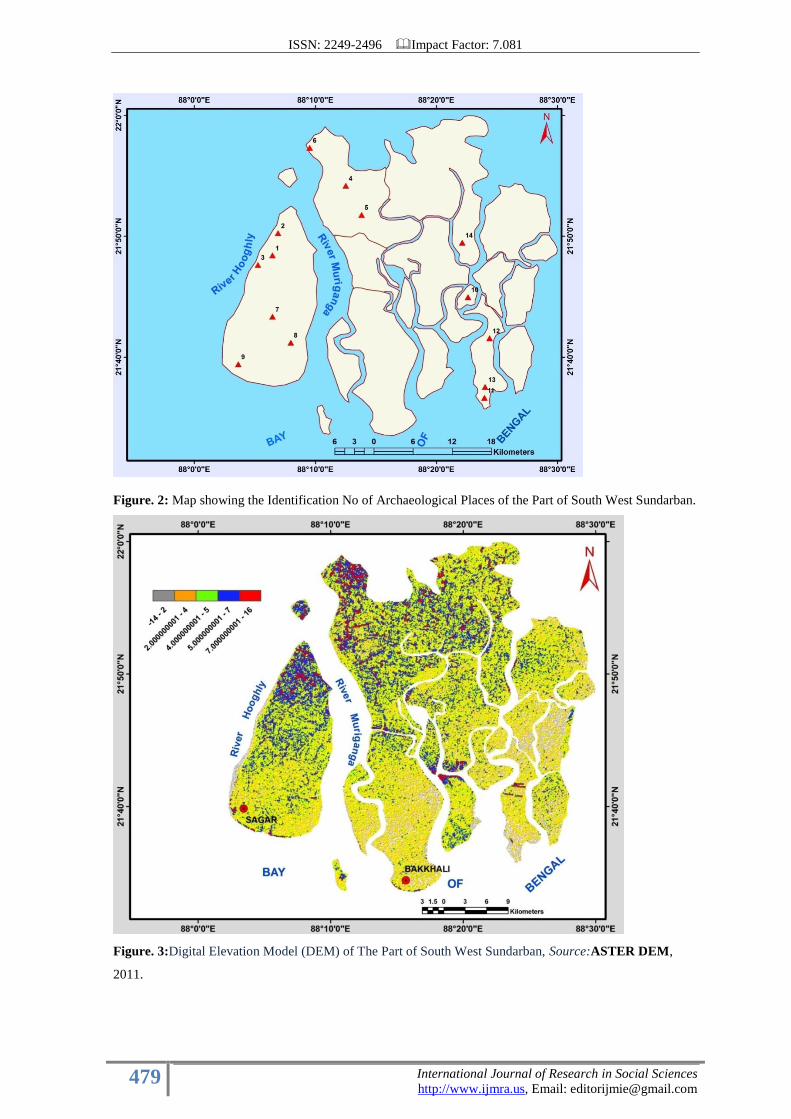
meter (Fig.3 & 4) above the sea level (ChattopadhyaySengupta, and Chakraborty.2005). The part
of south-west Sundarban of South 24 Paragana district (Fig.1), is under the active delta of the
Indian Sundarban delta system. The Indian Sundarbans delta is part of the delta of the Ganga-
Brahmaputra-Meghna basin in Asia (Danda&Sriskanthan, 2011). This part of the Ganga-
Brahmaputra-Meghna delta as we see it today came to be formed between 2500 and 5000 years ago
by the silt carried by the river Ganges (Allison et al, 2003) as well as its tributaries. The blanket of
Quaternary alluvium of the Ganga, and the Brahmhaputra, and their several tributaries and
distributaries conceals beneath it almost all the older rocks of the Bengal basin. Various
archaeological evidences have been discovered from entire Sundarban region at the time of forest
reclamations in British era. Including the area of South west Sundarban. Notable archaeological
sites of this region are Mandirtala, Sapkhali. Bamankhali, Pukurberia, Pakurtala ,Lat no -6,
Gobordhanpur, Buraburirtat and Surandraganjetc (Table, 1& Fig.2). The recent discovery of
ancient artifacts deep in the heart of the Sunderbans in West Bengal indicates that the region had
human habitation as early as the third century BC, and once again refutes the claim by colonial
historians that it was the British who made the Sundarbans habitable. During an exploration carried
out by the Directorate of Archaeology and Museums, Government of West Bengal, in
Govardhanpur and its adjacent Uttar Surendraganj, located near the mouth of the Ganga in the
interiors of the Sundarbans in South 24 Paraganas district, around 500 antiquities were found,
whose dates are ranging from as early as the third century BCE to as late as the 11th century A.D
(Chattopadhyay, 2015). The main aim of this study is a systematic arrangement of archaeological
sites with a physiographic view because History is around is the achievement of man (Nag,et.al
2007) and the man is an intellectual element of this landscape.
2. Research Method
The present work is deeply depended on the extensive literature review for the Archaeological
identification of places in the study area, especially the information‟s are used from different
ISSN: 2249-2496 Impact Factor: 7.081
473 International Journal of Research in Social Sciences
http://www.ijmra.us, Email: [email protected]
“IAR” (Indian Archaeology: a review), published by Department of Archaeology, Govt. of India.
Field study played an important role to examining the present geographical situation of the
archaeological sites and tracking GPS records. Fieldwork was conducted during winter of 2012,
2013 and 2014. Geographic information system (GIS) Technique is used for placing
archaeological sites on the present map. District planning map of south 24 paragana published by
National Atlas and Thematic Maping Organization (NATMO) are used. Images are joined using
mosaic tool of „Erdas Imagine‟9.1 to get total coverage of the study area map. The ASTER
(Advanced Space Borne Thermal Emission and Reflection Radiometer) elevation data with 30 m
resolution (GCS WGS84) of 2011 is downloaded from the website of the Earth Explorer
(http://earthexplorer.usgs.gov/) and it is also processed through „Erdas‟, using AOI and subset
tools. All unrectified raster and vector data are projected in UTM (Universal Transverse Mercator)
assigning datum of WGS84 (World Geodetic Survey, 1984) using the project raster tool of ArcGIS
9.3 software to overlap these data accurately. The contours of elevation are generated using
ASTER data and the spatial analyst tool of ArcGIS 9.3. Data are used from the website of central
Groundwater Board (CGWB), Govt. of India (www.cgwb.gov.in), of the district of south 24
Paragana, for better understanding the general geology, geomorphology and stratigraphy of the
study area. Geological Quadrangle map of Sagar (1:250,000 scale) was downloaded from the
website of geological survey of India (GSI), Govt. of India (www.portal.gsi.govt.in) for preparing
the general geological map of south west Sundarban part. In addition to the field survey, collecting
of archaeological information and taking photographs of archaeological evidences from different
museum located in the study area was also very helpful.
ISSN: 2249-2496 Impact Factor: 7.081
474 International Journal of Research in Social Sciences
http://www.ijmra.us, Email: [email protected]
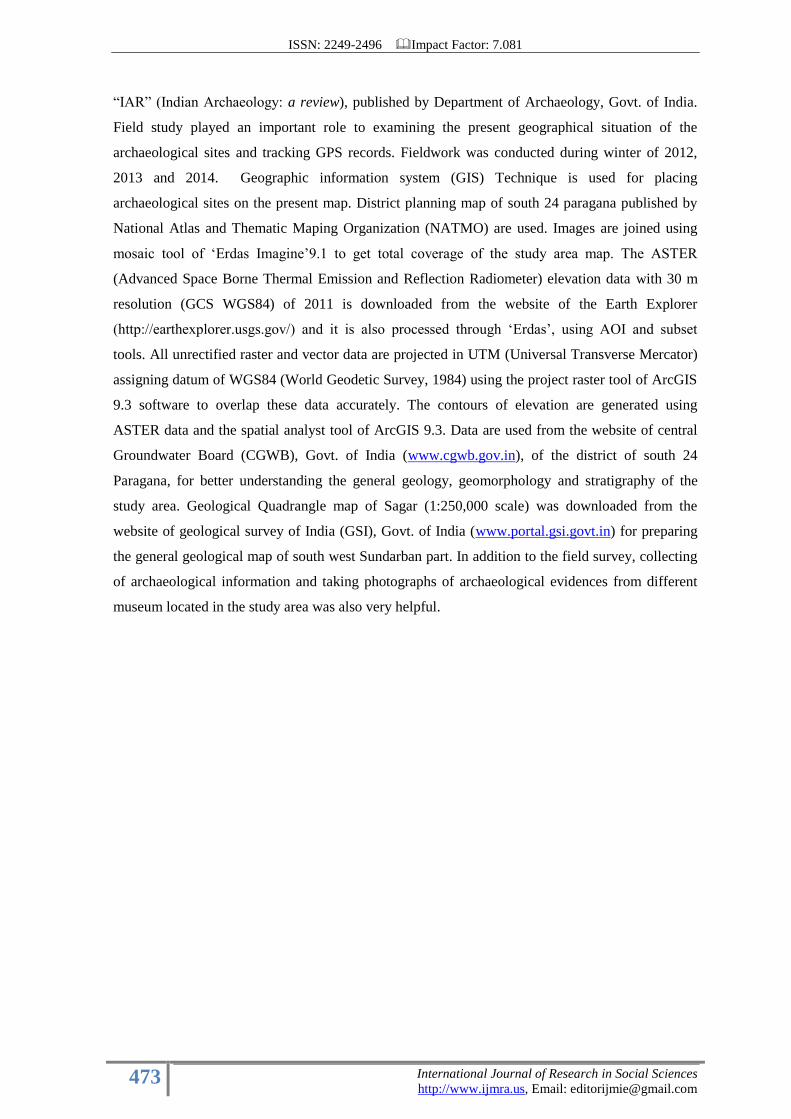
Figure. 1: Map of the study area – (a) location of West Bengal in India (b) District of
South 24 Paragana in West Bengal (c) Part of South West Sundarban including the
administrative blocks Kakdwip, Sagore, Namkhana and PatharPratima.
a
b
c
ISSN: 2249-2496 Impact Factor: 7.081
475 International Journal of Research in Social Sciences
http://www.ijmra.us, Email: [email protected]
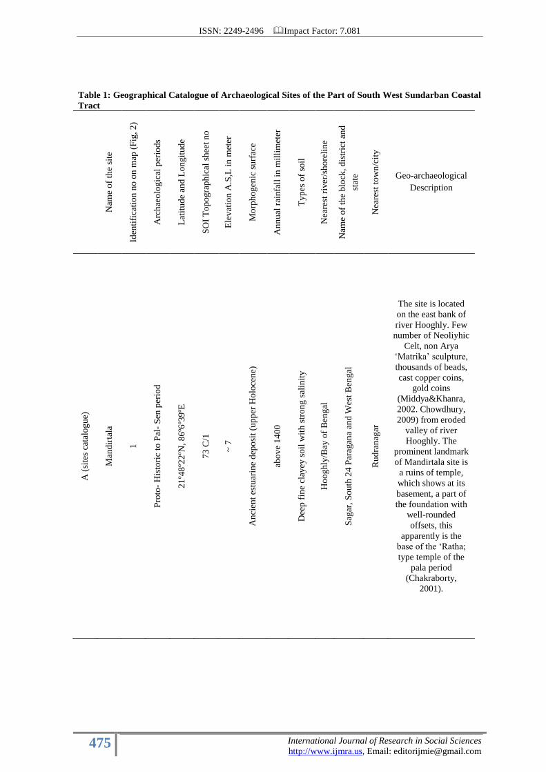
Table 1: Geographical Catalogue of Archaeological Sites of the Part of South West Sundarban Coastal
Tract
Nam
e o
f th
e si
te
Iden
tifi
cati
on
no
on
map
(F
ig, 2
)
Arc
hae
olo
gic
al p
erio
ds
Lat
itu
de
and
Lo
ng
itud
e
SO
I T
op
ogra
ph
ical
sh
eet
no
Ele
vat
ion
A.S
,L i
n m
eter
Mo
rph
og
enic
su
rfac
e
An
nu
al r
ainfa
ll i
n m
illi
met
er
Ty
pes
of
soil
Nea
rest
riv
er/s
ho
reli
ne
Nam
e o
f th
e b
lock
, d
istr
ict
and
stat
e
Nea
rest
to
wn
/cit
y
Geo-archaeological
Description
A (
site
s ca
talo
gu
e)
Man
dir
tala
1
Pro
to-
His
tori
c to
Pal
- S
en p
erio
d
21
º48º2
2ºN
, 8
6º6
º39
ºE
73
C/1
~ 7
An
cien
t es
tuar
ine
dep
osi
t (u
pper
Ho
loce
ne)
abo
ve
14
00
Dee
p f
ine
clay
ey s
oil
wit
h s
tro
ng
sal
init
y
Ho
og
hly
/Bay
of
Ben
gal
Sag
ar,
So
uth
24
Par
agan
a an
d W
est
Ben
gal
Ru
dra
nag
ar
The site is located
on the east bank of
river Hooghly. Few
number of Neoliyhic
Celt, non Arya
„Matrika‟ sculpture,
thousands of beads,
cast copper coins,
gold coins
(Middya&Khanra,
2002. Chowdhury,
2009) from eroded
valley of river
Hooghly. The
prominent landmark
of Mandirtala site is
a ruins of temple,
which shows at its
basement, a part of
the foundation with
well-rounded
offsets, this
apparently is the
base of the „Ratha;
type temple of the
pala period
(Chakraborty,
2001).
ISSN: 2249-2496 Impact Factor: 7.081
476 International Journal of Research in Social Sciences
http://www.ijmra.us, Email: [email protected]
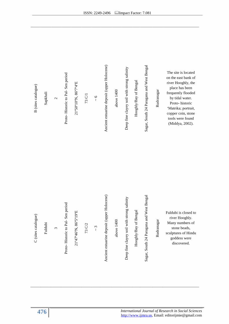
B (
site
s ca
talo
gu
e)
Sap
kh
ali
2
Pro
to-
His
tori
c to
Pal
- S
en p
erio
d
21
º50º1
0ºN
, 8
6º7
º4ºE
73
C/1
~ 6
An
cien
t es
tuar
ine
dep
osi
t (u
pper
Ho
loce
ne)
abo
ve
14
00
Dee
p f
ine
clay
ey s
oil
wit
h s
tro
ng
sal
init
y
Ho
og
hly
/Bay
of
Ben
gal
Sag
ar,
So
uth
24
Par
agan
a an
d W
est
Ben
gal
Ru
dra
nag
ar
The site is located
on the east bank of
river Hooghly, the
place has been
frequently flooded
by tidal water.
Proto- historic
„Matrika; portrait,
copper coin, stone
tools were found
(Middya, 2002).
C (
site
s ca
talo
gu
e)
Fu
ldu
bi
3
Pro
to-
His
tori
c to
Pal
- S
en p
erio
d
21
º47º4
6ºN
, 8
6º5
º19
ºE
73
C/2
~ 3
An
cien
t es
tuar
ine
dep
osi
t (u
pper
Ho
loce
ne)
abo
ve
14
00
Dee
p f
ine
clay
ey s
oil
wit
h s
tro
ng
sal
init
y
Ho
og
hly
/Bay
of
Ben
gal
Sag
ar,
So
uth
24
Par
agan
a an
d W
est
Ben
gal
Ru
dra
nag
ar
Fuldubi is closed to
river Hooghly.
Many numbers of
stone beads,
sculptures of Hindu
goddess were
discovered.
ISSN: 2249-2496 Impact Factor: 7.081
477 International Journal of Research in Social Sciences
http://www.ijmra.us, Email: [email protected]
D (
site
s ca
talo
gu
e)
Pak
urt
ala
4
Pro
to-
His
tori
c to
Pal
- S
en p
erio
d
21
º53º3
7ºN
, 8
8º1
3º1
0ºE
73
C/5
~ 6
An
cien
t es
tuar
ine
dep
osi
t (u
pper
Ho
loce
ne)
abo
ve
14
00
Dee
p f
ine
clay
ey s
oil
wit
h s
tro
ng
sal
init
y
Mu
rig
ang
a
Kak
dw
ipr,
So
uth
24 P
arag
ana
and
Wes
t B
eng
al
Kak
dw
ip (
6 k
m n
ort
h)
This archaeological
site is located on the
east bank of river
Muriganga, river
Kalnagini follow
near the village and
both are paleo
channel of
Adiganga. Notable
evidences of this
place are terracotta
beads; small pottery
vassals with basket
marks, semi-
precious stone
beads, punched
copper coin etc.
(Chakraborty,
2001).
E (
site
s ca
talo
gu
e)
Pu
ku
rber
ia
5
Pro
to-
His
tori
c to
Pal
- S
en p
erio
d
21
º50º5
3ºN
, 8
8º1
3º5
3ºE
73
C/5
~ 6
An
cien
t es
tuar
ine
dep
osi
t (u
pper
Ho
loce
ne)
abo
ve
14
00
Dee
p f
ine
clay
ey s
oil
wit
h m
od
erat
e sa
lin
ity
Mu
rig
ang
a
Kak
dw
ipr,
So
uth
24 P
arag
ana
and
Wes
t B
eng
al
Kak
dw
ip
This archaeological
site is located on the
east bank of river
Muriganga. Proto-
historic „Yakshini‟,
ancient terracotta
sculpture, vassal
characterize by
Greek style were
discovered.
ISSN: 2249-2496 Impact Factor: 7.081
478 International Journal of Research in Social Sciences
http://www.ijmra.us, Email: [email protected]
F (
site
s ca
talo
gu
e)
Lat
no
– 6
6
Pro
to-
His
tori
c to
Pal
- S
en p
erio
d
21
º57º4
ºN, 8
8º9
º46
ºE
No
t av
aila
ble
~ 5
An
cien
t es
tuar
ine
dep
osi
t (u
pper
Ho
loce
ne)
abo
ve
14
00
Dee
p f
ine
clay
ey s
oil
wit
h s
tro
ng
sal
init
y
Mu
rig
ang
a
Kak
dw
ipr,
So
uth
24 P
arag
ana
and
Wes
t B
eng
al
Kak
dw
ip
This archaeological
site is located on the
east bank of river
Muriganga along an
erosional surface.
Terracotta sculpture
of „Matrika‟,
different sculpture
with Roman and
Greek style were
found from here
(Chowdhury, 2009).
G (
site
s ca
talo
gu
e)
Ru
dra
nag
ar
7
Ear
ly H
isto
ric
21
º43º1
3ºN
, 8
8º6
º39
ºE
No
t av
aila
ble
~ 4
An
cien
t es
tuar
ine
dep
osi
t (u
pper
Ho
loce
ne)
abo
ve
14
00
Dee
p f
ine
clay
ey s
oil
wit
h s
tro
ng
sal
init
y
Mu
rig
ang
a
Sag
ar,
So
uth
24
Par
agan
a an
d W
est
Ben
gal
Gan
gas
agar
The site is located
on the west bank of
river Hooghly;
actually Rudranagar
is located on the
middle portion of
Sagar island.
Sculpture of
terracotta „Yakshini‟
and many numbers
of potteries were
discovered in the
depth of 2 meter
from surface
(Chowdhury, 2009).
ISSN: 2249-2496 Impact Factor: 7.081
479 International Journal of Research in Social Sciences
http://www.ijmra.us, Email: [email protected]
Figure. 2: Map showing the Identification No of Archaeological Places of the Part of South West Sundarban.
Figure. 3:Digital Elevation Model (DEM) of The Part of South West Sundarban, Source:ASTER DEM,
2011.
ISSN: 2249-2496 Impact Factor: 7.081
480 International Journal of Research in Social Sciences
http://www.ijmra.us, Email: [email protected]
H (
site
s ca
talo
gu
e)
Man
asad
wip
8
Lat
e H
isto
ric
to e
arly
med
iev
al
21
º41º1
3ºN
, 8
8º7
º53
ºE
No
t av
aila
ble
~ 4
An
cien
t es
tuar
ine
dep
osi
t (u
pper
Ho
loce
ne)
abo
ve
14
00
Dee
p f
ine
clay
ey s
oil
wit
h s
tro
ng
sal
init
y
Mu
rig
ang
a
Sag
ar,
So
uth
24
Par
agan
a an
d W
est
Ben
gal
Gan
gas
agar
Site is located on the
west bank of river
Muriganga.
Different terracotta
potteries, terracotta
bricks (size, 12”
*7*1 ¾”), remains
of building of Pal-
sen period were
discovered from a
local pond (Maity,
2002).
I (s
ites
cat
alo
gu
e)
Sag
ar
9
Ear
ly H
isto
ric
21
º39º2
8ºN
, 8
8º3
º23
ºE
79
C/2
~ 4
An
cien
t es
tuar
ine
dep
osi
t (u
pper
Ho
loce
ne)
abo
ve
14
00
Dee
p f
ine
clay
ey s
oil
wit
h s
tro
ng
sal
init
y
Bay
of
Ben
gal
Sag
ar,
So
uth
24
Par
agan
a an
d W
est
Ben
gal
Gan
gas
agar
Sagar is located on
the side of coastal
belt of Bay of
Bengal. This is a
erosional surface.
brocken part of
ancient brick,
sculpture of goddess
Bishnu, pottery oots
were found from
here ( Maity, 2002,
Chowdhury, 2009).
ISSN: 2249-2496 Impact Factor: 7.081
481 International Journal of Research in Social Sciences
http://www.ijmra.us, Email: [email protected]
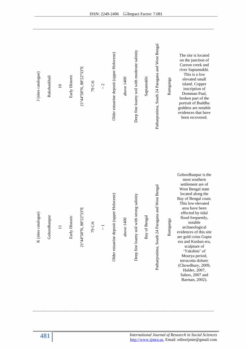
J (s
ites
cat
alo
gu
e)
Rak
shas
kh
ali
10
Ear
ly H
isto
ric
21
º44º5
8ºN
, 8
8º2
2º3
3ºE
79
C/6
~ 2
Old
er e
stu
arin
e d
epo
sit
(up
per
Ho
loce
ne)
abo
ve
14
00
Dee
p f
ine
loam
y s
oil
wit
h m
od
erat
e sa
lin
ity
Sap
tam
uk
hi
Pat
har
pra
tim
a, S
ou
th 2
4 P
arag
ana
and
Wes
t B
eng
al
Ram
gan
ga
The site is located
on the junction of
Curzon creek and
river Saptamukhi.
This is a low
elevated small
island. Copper
inscription of
Domman Paul,
broken part of the
portrait of Buddha
goddess are notable
evidences that have
been recovered.
K (
site
s ca
talo
gu
e)
Go
bo
rdh
anpu
r
11
Ear
ly H
isto
ric
21
º44º5
8ºN
, 8
8º2
2º3
3ºE
79
C/6
~ 1
Old
er e
stu
arin
e d
epo
sit
(up
per
Ho
loce
ne)
abo
ve
14
00
Dee
p f
ine
loam
y s
oil
wit
h s
tron
g s
alin
ity
Bay
of
Ben
gal
Pat
har
pra
tim
a, S
ou
th 2
4 P
arag
ana
and
Wes
t B
eng
al
Ram
gan
ga
Gobordhanpur is the
most southern
settlement are of
West Bengal state
located along the
Bay of Bengal coast.
This low elevated
area have been
effected by tidal
flood frequently,
notable
archaeological
evidences of this site
are gold coins Gupta
era and Kushan era,
sculpture of
„Yakshini‟ of
Mourya period,
terracotta dolsetc
(Chowdhury, 2009,
Halder, 2007,
Sahoo, 2007 and
Barman, 2002).
ISSN: 2249-2496 Impact Factor: 7.081
482 International Journal of Research in Social Sciences
http://www.ijmra.us, Email: [email protected]
L (
site
s ca
talo
gu
e)
Su
ren
dra
gan
j n
ort
h
12
Ear
ly H
isto
ric
21
º41º3
3ºN
, 8
8º2
4º2
1ºE
No
t av
aila
ble
~ 8
Old
er e
stu
arin
e d
epo
sit
(up
per
Ho
loce
ne)
abo
ve
14
00
Dee
p f
ine
loam
y s
oil
wit
h s
tron
g s
alin
ity
Cu
rzo
n c
reek
Pat
har
pra
tim
a, S
ou
th 2
4 P
arag
ana
and
Wes
t B
eng
al
Ram
gan
ga
The site is located
on west bank of
Curzon creek,
physiographicaly
this region is estuary
margin tidal or the
valley flats along the
margins of tidal
rivers (Paul, 2011).
Sculpture of
goddess Bishnu and
Ganesha and
substantial amount
of ancient potteries
were found
(Mandal, 2010).
M (
site
s ca
talo
gu
e)
Bu
rab
uri
r T
at
13
Ear
ly H
isto
ric
21
º37º3
2ºN
, 8
8º2
3º2
9ºE
79
C/6
~ 2
Old
er e
stu
arin
e d
epo
sit
(up
per
Ho
loce
ne)
abo
ve
14
00
Dee
p f
ine
loam
y s
oil
wit
h s
tron
g s
alin
ity
Bay
ofB
eng
al
Pat
har
pra
tim
a, S
ou
th 2
4 P
arag
ana
and
Wes
t B
eng
al
Ram
gan
ga
The archaeological
site is located in
nearby area of Bay
of Bengal along the
sandy and muddy
shoreline. Notable
evidences that have
been discovered are
– gold coins of
Shasanka and 2nd
Chandragupta,
terracotta dolls etc.
(Chowdhury, 2009,
Halder, 2007,
Sahoo, 2007 and
Barman, 2002).
ISSN: 2249-2496 Impact Factor: 7.081
483 International Journal of Research in Social Sciences
http://www.ijmra.us, Email: [email protected]
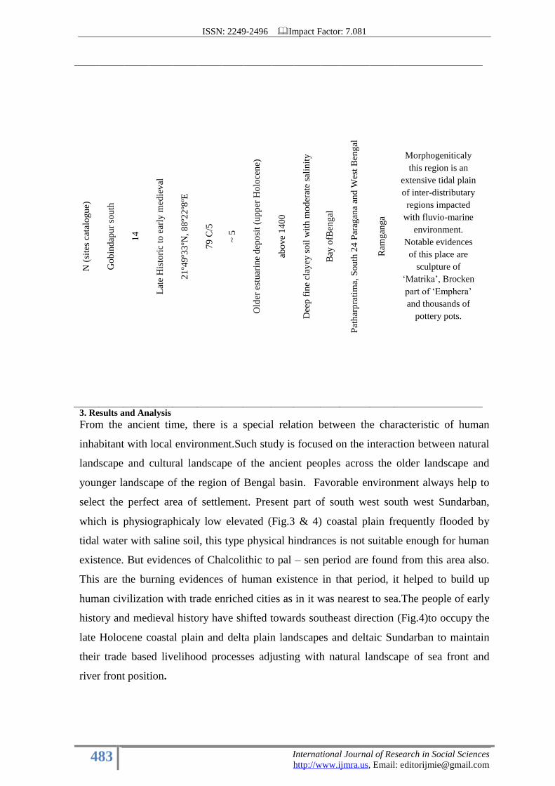
N (
site
s ca
talo
gu
e)
Go
bin
dap
ur
sou
th
14
Lat
e H
isto
ric
to e
arly
med
iev
al
21
º49º3
3ºN
, 8
8º2
2º8
ºE
79
C/5
~ 5
Old
er e
stu
arin
e d
epo
sit
(up
per
Ho
loce
ne)
abo
ve
14
00
Dee
p f
ine
clay
ey s
oil
wit
h m
od
erat
e sa
lin
ity
Bay
ofB
eng
al
Pat
har
pra
tim
a, S
ou
th 2
4 P
arag
ana
and
Wes
t B
eng
al
Ram
gan
ga
Morphogeniticaly
this region is an
extensive tidal plain
of inter-distributary
regions impacted
with fluvio-marine
environment.
Notable evidences
of this place are
sculpture of
„Matrika‟, Brocken
part of „Emphera‟
and thousands of
pottery pots.
3. Results and Analysis
From the ancient time, there is a special relation between the characteristic of human
inhabitant with local environment.Such study is focused on the interaction between natural
landscape and cultural landscape of the ancient peoples across the older landscape and
younger landscape of the region of Bengal basin. Favorable environment always help to
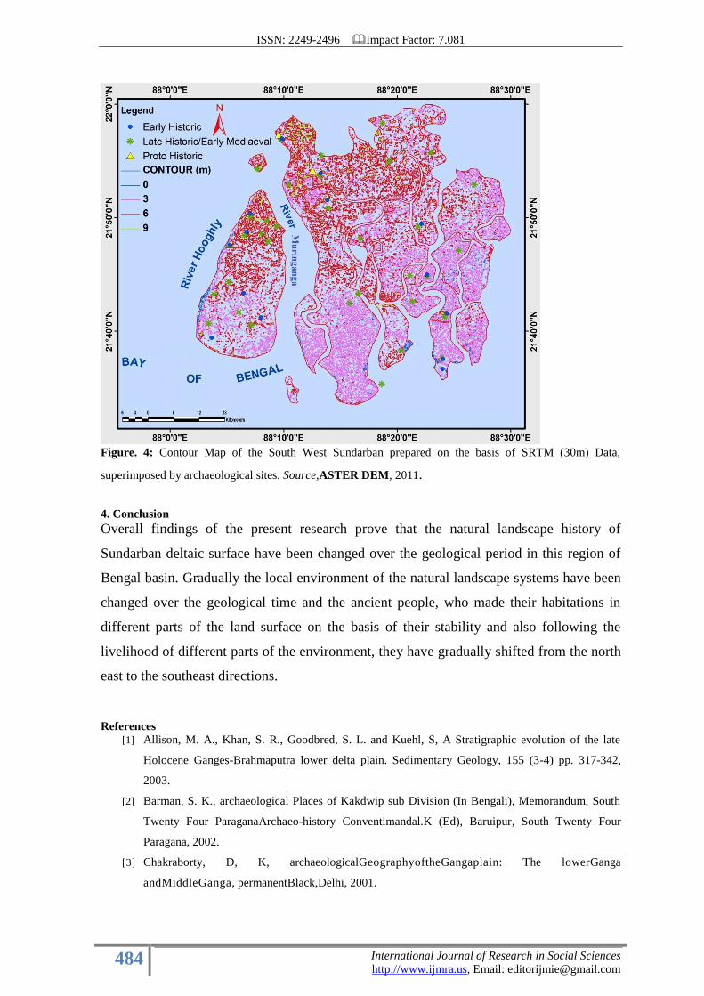
select the perfect area of settlement. Present part of south west south west Sundarban,
which is physiographicaly low elevated (Fig.3 & 4) coastal plain frequently flooded by
tidal water with saline soil, this type physical hindrances is not suitable enough for human
existence. But evidences of Chalcolithic to pal – sen period are found from this area also.
This are the burning evidences of human existence in that period, it helped to build up
human civilization with trade enriched cities as in it was nearest to sea.The people of early
history and medieval history have shifted towards southeast direction (Fig.4)to occupy the
late Holocene coastal plain and delta plain landscapes and deltaic Sundarban to maintain
their trade based livelihood processes adjusting with natural landscape of sea front and
river front position.
ISSN: 2249-2496 Impact Factor: 7.081
484 International Journal of Research in Social Sciences
http://www.ijmra.us, Email: [email protected]
Figure. 4: Contour Map of the South West Sundarban prepared on the basis of SRTM (30m) Data,
superimposed by archaeological sites. Source,ASTER DEM, 2011.
4. Conclusion
Overall findings of the present research prove that the natural landscape history of
Sundarban deltaic surface have been changed over the geological period in this region of
Bengal basin. Gradually the local environment of the natural landscape systems have been
changed over the geological time and the ancient people, who made their habitations in
different parts of the land surface on the basis of their stability and also following the
livelihood of different parts of the environment, they have gradually shifted from the north
east to the southeast directions.
References [1] Allison, M. A., Khan, S. R., Goodbred, S. L. and Kuehl, S, A Stratigraphic evolution of the late
Holocene Ganges-Brahmaputra lower delta plain. Sedimentary Geology, 155 (3-4) pp. 317-342,
2003.
[2] Barman, S. K., archaeological Places of Kakdwip sub Division (In Bengali), Memorandum, South
Twenty Four ParaganaArchaeo-history Conventimandal.K (Ed), Baruipur, South Twenty Four
Paragana, 2002.
[3] Chakraborty, D, K, archaeologicalGeographyoftheGangaplain: The lowerGanga
andMiddleGanga, permanentBlack,Delhi, 2001.
ISSN: 2249-2496 Impact Factor: 7.081
485 International Journal of Research in Social Sciences
http://www.ijmra.us, Email: [email protected]
[4] Chattopadhyay, B. D, Sengupta, G.Chakraborty, S. (Ed), An Annotated Archaeological Atlas of
West Bengal, Vol.I, Prehistory and Protohistory, Centre forArchaeological studies and Training,
Eastern India, Kolkata, 2005.
[5] Chattopadhyay, S.S, Settlement of History, FRONTLINE,
http://www.frontline.in/artsandculture/heritage/settlementofhistory/ article5486821.ece,
2015.
[6] Chowdhury, K, A cultural History of 24 Paragana (In Bengali), Deyspublishing.Kolkata,
2009.
[7] Danda. A. A and Sriskanthan. G, Indian Sundarbans Delta: A Vision, WWF-India, 2011.
[8] Haldar, N. Archaeology of Kakdwip sub-division (in Bengali), Memorandum, south 24
ParaganaArchaeo-History Convention, Board of Editors, PratnaItihasCharchaSamiti, 2007.
[9] Jain.V, K, Prehistory and Proto history of India- an Appraisal- Paleolithic- Non- Harappan
Chalcolithic cultures, Print World, New Delhi, 2014.
[10] Khanra, A. The Sagar – Mandirtala Museum (in Bengali). Memorandum, south 24
ParaganaArchaeo-History, Convention, Mandal, K (Ed), Baruipur South Twenty Four
Paragana, 2002.
[11] Maity, J. Archaeological Evidences of Sagar Island, (in Bengali), Memorandum, south 24
ParaganaArchaeo-. History Convention, Mandal, K (Ed), Baruipur, South Twenty Four
Paragana, 2002.
[12] Mandal, K. Some portrait – sculpture of Sundarban, (in Bengali), Nabachalantika, Kolkata,
2010.
[13] Middya, D. The south 24 Paraganas, from the light of Archaeology, (in Bengali),
Memorandum, south 24 ParaganaArchaeo-. History Convention, Mandal, K (Ed),Baruipur,
South Twenty Four Paragana. 2002.
[14] Nag, P. (Ed). Historical Atlas of India, NATMO, Kolkata, 2007.
[15] Paul, A.K.Man-Environment interaction in the single largest mangrove along the Shoreline
of the Bay of Bengal: a case study of Sundarban, Geomorphology of India, ed. Sharma &
Kale, PrayagpustakBhawan. Allahabad. Pp, 263-286, 2011.