Geoglyphs of Titicaca, Peru, by A.C. Sparavigna
7
The geoglyphs of Titicaca Amelia Carolina Sparavigna, Politecnico di Torino Abstract: Geoglyphs created in an ancient network of earthworks are shown, using Google satellite imagery enhanced by an image processing. This network covers a large part of the land near the Titicaca Lake. Satellite images display the slopes of hills criss-crossed with terrace walls and the surfaces of the plains covered with raised fields, indicating that this was once a highly productive agricultural place for the south central Andes. Among geoglyphs there are structures which represent animals, where ponds are their eyes. Other geoglyphs are geometric drawings. Keywords: Satellite maps, Landforms, Artificial landforms, Geo-glyphs, Image processing, Archaeology Any landform composed of fine-grained materials evolves in wide and flat relieves, due to the down-slope transport of its materials over time. Earthworks, which are artificial landforms, are subjected to the same destiny, to be widened and flattened as a consequence of the natural degradation processes [1-3]. These ancient structures are clearly displayed by satellite imagery as a texture superimposed to the background landform. In some cases, they remain quite visible and, on them, the modern structures. A wonderful example of a huge network of earthworks exists. It covers a total of 120,000 hectares of the land near the Titicaca Lake, being the result of an almost unimaginable agricultural effort of ancient Andean people. This network of earthworks is the remains of an extensive ancient agricultural system built and used by Andean peoples centuries ago, throughout the vast high plain surrounding Titicaca. People created a system of terraced hills and raised fields, which were large elevated planting platforms, with the corresponding drainage canals, to improved soil conditions and temperature and moisture conditions for crops. These remains of the prehistoric agricultural system are providing evidence of the impressive engineering abilities of the peoples who lived there in pre-Columbian times. The local farmers call the artificial landforms "waru waru" or "camellones" (pre-Hispanic raised fields are present in other regions too [4-7]). They had no idea that these textures are the persisting evidence of the remarkable skills of their ancestors, until 1981, when Clark Erickson, University of Illinois, recognized the significance of waru waru. He and other researchers started an experimental reintroduction of raised fields, in the Huatta, a land near the lake, in Peru, persuading some local farmers to rebuild a few of the raised fields, plant them in indigenous crops, and farm in traditional manner [7]. Let us remember that Lake Titicaca sits 3,811 m above sea level, in a basin high in the Andes on the border of Peru and Bolivia. The western part of the lake lies within the Puno Region of Peru, and the eastern side is located in the Bolivian La Paz Department. Both regions have the slopes of the hills criss-crossed with terrace walls. Satellite imagery shows some parts of the plain surfaces still covered with raised fields.
-
Upload
amelia-carolina-sparavigna -
Category
Documents
-
view
149 -
download
1
description
Geoglyphs created in an ancient network of earthworks are shown, using Google satellite imagery enhanced by an image processing. This network covers a large part of the landnear the Titicaca Lake. Among geoglyphs there are structures which represent animals, where ponds are their eyes. Other geoglyphs are geometric drawings.
Transcript of Geoglyphs of Titicaca, Peru, by A.C. Sparavigna

The geoglyphs of Titicaca
Amelia Carolina Sparavigna, Politecnico di Torino
Abstract: Geoglyphs created in an ancient network of earthworks are shown, using Google
satellite imagery enhanced by an image processing. This network covers a large part of the land
near the Titicaca Lake. Satellite images display the slopes of hills criss-crossed with terrace walls
and the surfaces of the plains covered with raised fields, indicating that this was once a highly
productive agricultural place for the south central Andes. Among geoglyphs there are structures
which represent animals, where ponds are their eyes. Other geoglyphs are geometric drawings.
Keywords: Satellite maps, Landforms, Artificial landforms, Geo-glyphs, Image processing,
Archaeology
Any landform composed of fine-grained materials evolves in wide and flat relieves, due to the
down-slope transport of its materials over time. Earthworks, which are artificial landforms, are
subjected to the same destiny, to be widened and flattened as a consequence of the natural
degradation processes [1-3]. These ancient structures are clearly displayed by satellite imagery
as a texture superimposed to the background landform. In some cases, they remain quite visible
and, on them, the modern structures.
A wonderful example of a huge network of earthworks exists. It covers a total of 120,000 hectares
of the land near the Titicaca Lake, being the result of an almost unimaginable agricultural effort of
ancient Andean people. This network of earthworks is the remains of an extensive ancient
agricultural system built and used by Andean peoples centuries ago, throughout the vast high
plain surrounding Titicaca. People created a system of terraced hills and raised fields, which were
large elevated planting platforms, with the corresponding drainage canals, to improved soil
conditions and temperature and moisture conditions for crops. These remains of the prehistoric
agricultural system are providing evidence of the impressive engineering abilities of the peoples
who lived there in pre-Columbian times. The local farmers call the artificial landforms "waru
waru" or "camellones" (pre-Hispanic raised fields are present in other regions too [4-7]). They
had no idea that these textures are the persisting evidence of the remarkable skills of their
ancestors, until 1981, when Clark Erickson, University of Illinois, recognized the significance of
waru waru. He and other researchers started an experimental reintroduction of raised fields, in the
Huatta, a land near the lake, in Peru, persuading some local farmers to rebuild a few of the raised
fields, plant them in indigenous crops, and farm in traditional manner [7].
Let us remember that Lake Titicaca sits 3,811 m above sea level, in a basin high in the Andes on
the border of Peru and Bolivia. The western part of the lake lies within the Puno Region of Peru,
and the eastern side is located in the Bolivian La Paz Department. Both regions have the slopes of
the hills criss-crossed with terrace walls. Satellite imagery shows some parts of the plain surfaces
still covered with raised fields.

Figure 1: This is a part of the land near Lake Titicaca (Huatta, Peru). In the upper panel, the image from
Google, in the lower one, the image enhanced with a previously proposed method [8]. Coordinates are
shown in the figure.
Figure 2: The head of a bird, where the beak is
touching an old dry channel. Coordinates are shown in the figure.
Let us observe the region of Titicaca Lake with Google Maps. We see raised fields having
different forms and size, generally being 4-10 m wide, 10 to 100 m long. Some early fields were
narrow ridges of 5 m wavelength. In fact, at later times, the wavelength increased for larger fields
to 10 m [7]. In spite of erosion, the raised fields are clearly visible from the space. For instance,

Figure 1 shows a piece of this land (Huatta). Observing the figure, we can argue that the creation
of these earthworks was previously planned, following the natural slope of the terrain. Another
example in Fig.2, it seems the head of a bird, where the beak is touching an old dry channel.
Many other interesting drawings are displayed by the satellite imagery, some of them having a
quite evident symbolic structure, being then geoglyphs of huge dimensions.
In Figure 3 we see a bird, where a circular pond is the eye. In Figure 4, it looks like a condor being
represented on the surface. For the images, a processing method [8] was used that enhances the
edges of earthworks. Two birds can be seen in Fig.5, the big one is protecting a canal with its beak
and claw. In Fig.6, there is an animal that could be a hedgehog. Another artificial landform that
could be a geo-glyph (a fish or a tortoise) is located at coordinates approx. -15.6464,-70.132. In
Fig.7, a complex scene composed by a snake and an animal assailing it, covering a huge surface.
Landforms in Figures 1-7 are in Peru districts. A rule of thumb: to find the figures, look for
circular ponds, because sometimes they can be the eye of an animal.
Figure 3: Many interesting drawings are displayed in
the satellite imagery of this land. Among them, there
are some which look as geo-glyphs. Here we see a
bird, where a circular pond is the eye. In the upper
panel, the original image from Google, in the lower
part the image enhanced with a previously proposed
method [8].

Figure 4. This landform appears as a geo-glyph
representing a condor. In the upper panel, the original image from Google, in the lower part the image, the
head enhanced with a previously proposed method [8].
Figure 5: Two
geoglyphs in
this area. They
seem two birds.
One is near the
canal with beak
and (white)
claw at the
bends of it. A
green pond is
the eye.
Another figure
is in the lower
right part of
figure.

Figure 6: This artificial landform could
represent a hedgehog. Coordinates of hedgehog are -15.65154,-70.1334 (upside-down).
Figure 7: This is a
huge geoglyphs. On
the left, a snake with a
bifid tongue, on the
right an animal
assailing it. The body
and skin of the snake
are created by the
terraced hill, the head
(darker area) is on the
plain surface of the
ground, a pond as its
eye. The figure is
reproducing a region
2500 m x 3000 m.
Coordinates are -
15.6281,-70.21858.
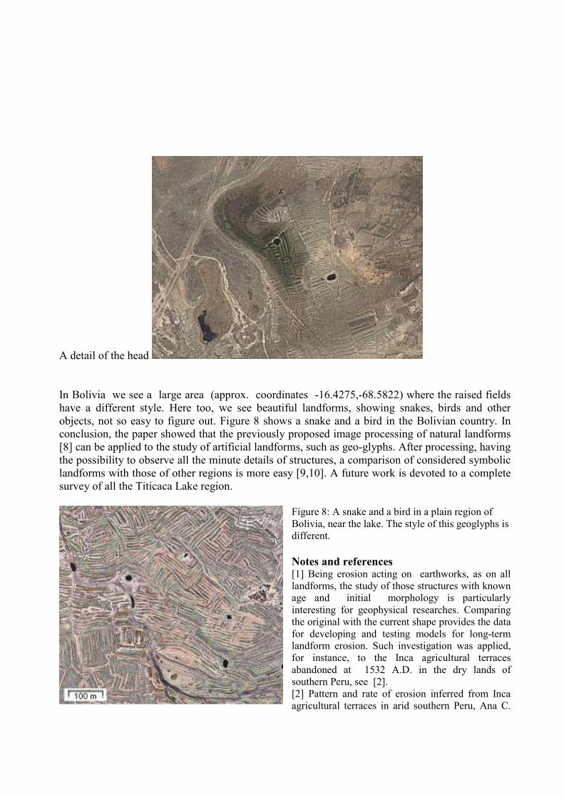
A detail of the head
In Bolivia we see a large area (approx. coordinates -16.4275,-68.5822) where the raised fields
have a different style. Here too, we see beautiful landforms, showing snakes, birds and other
objects, not so easy to figure out. Figure 8 shows a snake and a bird in the Bolivian country. In
conclusion, the paper showed that the previously proposed image processing of natural landforms
[8] can be applied to the study of artificial landforms, such as geo-glyphs. After processing, having
the possibility to observe all the minute details of structures, a comparison of considered symbolic
landforms with those of other regions is more easy [9,10]. A future work is devoted to a complete
survey of all the Titicaca Lake region.
Figure 8: A snake and a bird in a plain region of
Bolivia, near the lake. The style of this geoglyphs is
different.
Notes and references [1] Being erosion acting on earthworks, as on all
landforms, the study of those structures with known
age and initial morphology is particularly
interesting for geophysical researches. Comparing
the original with the current shape provides the data
for developing and testing models for long-term
landform erosion. Such investigation was applied,
for instance, to the Inca agricultural terraces
abandoned at 1532 A.D. in the dry lands of
southern Peru, see [2].
[2] Pattern and rate of erosion inferred from Inca
agricultural terraces in arid southern Peru, Ana C.

Londoño, Geomorphology, Volume 99, Issues 1-4, 1 July 2008, Pages 13-25
[3] Modeling the natural degradation of earthworks, M.A. O'Neal, M.E. O'Mansky, J.A. MacGregor,
Geoarchaeology,Volume 20, Issue 7, October 2005, Pages 739–748
[4] Pre-Columbian earthworks in coastal Amazonia, S. Rostain, Diversity, Volume 2, 2010, Pages 331-
352
[5] Pre-Hispanic Raised Field Agriculture, C. Erickson, web page, http://www.sas.upenn.edu/~cerickso/
[6] Agricultural Earthworks on the French Guiana Coast, S. Rostain, The Handbook of South-American
archaeology, Volume 3, 2008, Pages 217-233
[7] Raised field agriculture in the Lake Titicaca basin, C.L. Erickson, Expedition, Volume 30(1), 1988,
Pages 8-16
[8] Enhancing the Google imagery using a wavelet filter, A.C. Sparavigna, 8 Sept 2010. Geophysics
(physics.geo-ph); Earth and Planetary Astrophysics (astro-ph.EP), arXiv:1009.1590v1
[9] A huge literature is available on the subject of geo-glyphs. Let the author note an article with several
images, with a surprising title: Discovery of vast prehistoric works built by Giants? The Geoglyphs of
Teohuanaco, David E. Flynn, a post of February 24, 2008
[10] http://www.atlantisbolivia.org/geoforms.htm
Copyright note. Amelia Carolina Sparavigna is the owner of copyright. Material - including text
and images - on this site must not be copied or in any other way reproduced without explicit, prior
and written permission.
Other papers are:
A.C. Sparavigna, Symbolic landforms created by ancient earthworks near Lake Titicaca,
http://arxiv.org/abs/1009.2231, Cited by http://www.technologyreview.com/blog/arxiv/25770/
A.C. Sparavigna, Geoglyphs of Titicaca as an ancient example of graphic design,
http://arxiv4.library.cornell.edu/abs/1009.4602
Other images at http://www.lulu.com/items/volume_68/9395000/9395400/5/print/Symbolic-
landforms-bh.pdf
Amelia Carolina Sparavigna, 2010