GEOG081 GeoTechniques Syl final r3 - University of...
7
1 GEOG 081: Introduction to GeoTechniques Spring 2014 Dr. Ingrid L. Nelson ([email protected]) Class Meetings: M & W 9:3510:25 in Lafayette L311 Labs: F 9:3510:25 (A01); 10:4011:30 (A02) in Lafayette 203 Office: Old Mill 212 Office hrs: M & W 10:3012:00 (in GIS lab), or by appointment Translation: ‘Quelimane on Top of the World’ map painted on the wall of a pizza restaurant in the city of Quelimane, Zambézia, Mozambique. Photo taken by Ingrid L. Nelson, November 13 th , 2009 Course Overview and Structure This course introduces students to core geospatial concepts and techniques used by geographers across subdisciplinary interests: from urban geography to medical geography, climatology, biogeography, political ecology, cartography and beyond. The course is required for all geography majors at UVM, and thus provides essential knowledge and skills for all geographical interests. As we learn how to read maps and to use GIS (geographic information systems), we will also begin to approach maps with a critical eye, engaging the key ethical and political implications of mapping. This course is not a ‘memorize which options to click in ESRI’s ArcGIS software’ course. Rather, this course prepares students with the fundamental concepts necessary for beginning to work through geospatial problems and to approach mapreading, mapmaking and spatial analysis for addressing real world problems. By the end of the semester, students will be prepared to pursue more advanced collegiate studies that utilize GIS and/or remote sensing and cartographic techniques. NOTE: This syllabus is subject to change within the first few weeks of the course. All assignments except quizzes will be announced at least one week in advance.
Transcript of GEOG081 GeoTechniques Syl final r3 - University of...

1
GEOG 081: Introduction to GeoTechniques Spring 2014 Dr. Ingrid L. Nelson ([email protected]) Class Meetings: M & W 9:35-‐10:25 in Lafayette L311 Labs: F 9:35-‐10:25 (A01); 10:40-‐11:30 (A02) in Lafayette 203 Office: Old Mill 212
Office hrs: M & W 10:30-‐12:00 (in GIS lab), or by appointment
Translation: ‘Quelimane on Top of the World’ map painted on the wall of a pizza restaurant in the city of Quelimane, Zambézia, Mozambique. Photo taken by Ingrid L. Nelson, November 13th, 2009 Course Overview and Structure This course introduces students to core geospatial concepts and techniques used by geographers across sub-‐disciplinary interests: from urban geography to medical geography, climatology, biogeography, political ecology, cartography and beyond. The course is required for all geography majors at UVM, and thus provides essential knowledge and skills for all geographical interests. As we learn how to read maps and to use GIS (geographic information systems), we will also begin to approach maps with a critical eye, engaging the key ethical and political implications of mapping. This course is not a ‘memorize which options to click in ESRI’s ArcGIS software’ course. Rather, this course prepares students with the fundamental concepts necessary for beginning to work through geospatial problems and to approach map-‐reading, map-‐making and spatial analysis for addressing real world problems. By the end of the semester, students will be prepared to pursue more advanced collegiate studies that utilize GIS and/or remote sensing and cartographic techniques.
NOTE: This syllabus is subject to change within the first few weeks of the course. All assignments except quizzes will be announced at least one week in advance.

2
Learning Objectives This course will provide you with opportunities to:
• Identify the scope and breadth of geospatial concepts and specific geographical techniques across sub-‐disciplinary areas of interest in geography.
• Apply core geospatial concepts and spatial thinking in lab exercises. • Develop basic technical skills in GIS software and spatial analysis. • Identify the broad scope of potential real-‐world applications of geospatial concepts and
techniques. • Explore introductory qualitative and quantitative data interpretation and methods. • Work in small groups to conduct basic analysis in a way that enhances both individual and
collective communication of and understanding of specific geographical concepts. • Engage in critical reflection and discussion of the ethical dimensions of mapping with an
understanding that mapping is political and requires that we always consider who maps for whom and with what intentions and agendas.
• Build an awareness of the on-‐campus and off-‐campus resources for geographical analysis as well as the potential career pathways that require geotechniques preparation.
Course Texts, Equipment, Readings and Online Resources
Required Texts: Both available at the UVM Bookstore ● Meacham, A.W. Rodman and A.Y. Steingisser. 2012. Atlas of Yellowstone.
Berkeley, CA: University of California Press. [‘AY’ in Assignment Schedule] ● Monmonier, M.S. 1996. How to Lie with Maps (second edition). Chicago, IL:
University of Chicago Press. [‘Monmonier’ in Assignment Schedule] Required Equipment: Compass available at the UVM Bookstore
● Treknor T580 baseplate (flat) map compass with 1:24,000 map scale ● Course flash drive (for course material only) with minimum 16GB capacity for all
course data due to slow server speed in Lafayette (obtain by week 2)
Required Readings: Readings will include both of the required course texts AND other readings in .pdf format posted to our course Blackboard site (bb.uvm.edu). These must be read and brought to class (in digital or printed format) on the specified dates.
Online Resources: Course PowerPoint slides (when applicable, as I use ‘old school’ chalk/marker
board for many explanations of the material), lab exercises, assignment materials and links to resources/databases will be posted on our course Blackboard site. Note: If you encounter difficulties accessing the class Blackboard website, contact UVM Computing Helpline regarding connectivity ((802) 656-‐2604; email: [email protected]) or contact Prof. Nelson regarding content ([email protected])).
Course Format Geography 081 consists of 10 topic-‐focused sections, some of which extend beyond one week in length. Monday / Wednesday lectures and discussions will be accompanied by Friday lab sessions. Some class time slots will frequently be used for additional lab-‐based instruction when possible. Each course section will include readings, assignments, and 1-‐2 Friday lab exercises. Details for section #1 (Course Introduction) are included on the last page of this syllabus and in Blackboard. Details for subsequent sections will be distributed on a week-‐to-‐week basis and posted in Blackboard.
3
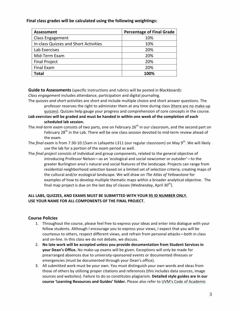
Final class grades will be calculated using the following weightings:
Assessment Percentage of Final Grade Class Engagement 10% In-‐class Quizzes and Short Activities 10% Lab Exercises 20% Mid-‐Term Exam 20% Final Project 20% Final Exam 20% Total 100%
Guide to Assessments (specific instructions and rubrics will be posted in Blackboard): Class engagement includes attendance, participation and digital journaling. The quizzes and short activities are short and include multiple choice and short answer questions. The
professor reserves the right to administer them at any time during class (there are no make-‐up quizzes). Quizzes help gauge your progress and comprehension of core concepts in the course.
Lab exercises will be graded and must be handed in within one week of the completion of each scheduled lab session.
The mid-‐term exam consists of two parts, one on February 26th in our classroom, and the second part on February 28th in the Lab. There will be one class session devoted to mid-‐term review ahead of the exam.
The final exam is from 7:30-‐10:15am in Lafayette L311 (our regular classroom) on May 9th. We will likely use the lab for a portion of the exam period as well.
The final project consists of individual and group components, related to the general objective of introducing Professor Nelson—as an ‘ecological and social newcomer or outsider’—to the greater Burlington area’s natural and social features of the landscape. Projects can range from residential neighborhood selection based on a limited set of selection criteria, creating maps of the cultural and/or ecological landscape. We will draw on The Atlas of Yellowstone for examples of how to develop multiple thematic maps within a broader analytical objective. The final map project is due on the last day of classes (Wednesday, April 30th).
ALL LABS, QUIZZES, AND EXAMS MUST BE SUBMITTED WITH YOUR 95 ID NUMBER ONLY. USE YOUR NAME FOR ALL COMPONENTS OF THE FINAL PROJECT. Course Policies
1. Throughout the course, please feel free to express your ideas and enter into dialogue with your fellow students. Although I encourage you to express your views, I expect that you will be courteous to others, respect different views, and refrain from personal attacks—both in class and on-‐line. In this class we do not debate, we discuss.
2. No late work will be accepted unless you provide documentation from Student Services in your Dean’s Office. No make-‐up exams will be given. Exceptions will only be made for prearranged absences due to university-‐sponsored events or documented illnesses or emergencies (must be documented through your Dean’s office).
3. All submitted work must be your own. You must distinguish your own words and ideas from those of others by utilizing proper citations and references (this includes data sources, image sources and websites). Failure to do so constitutes plagiarism. Detailed style guides are in our course ‘Learning Resources and Guides’ folder. Please also refer to UVM's Code of Academic

4
Integrity and the Academic Integrity Program in The Center for Student Ethics and Standards for further clarification.
4. During class, all phones must be turned off (no texting allowed). Laptops may be used for taking notes and for lab activity only (when authorized by the professor) and must not be connected to the Internet during class unless the lab activity requires this. All assigned readings must be complete before class and all students must arrive on time. Disruptive behavior will not be tolerated. Failure to abide by these expectations will result in a reduced class engagement grade or disenrollment.
5. ACCESS: I encourage students with documented disabilities to contact me during office hours or via email in the first two weeks of classes to discuss and arrange accommodations in co-‐ordination with the ACCESS office.
6. All classroom policies, including athletic and religious schedule accommodations, follow UVM policy, which can be viewed at http://www.uvm.edu/cses.
7. Consistent with the University’s policy on intellectual property rights, teaching and curricular materials (including but not limited to classroom lectures, class notes, exams, handouts, and presentations) are the property of the instructor and/or Pete Young. Therefore, electronic recording and/or transmission of classes or class notes is prohibited without the express written permission of the instructor. Such permission is to be considered unique to the needs of an individual student (e.g. ADA compliance), and not a license for permanent retention or electronic dissemination to others.

5
GEOG 081 Introduction to GeoTechniques – Schedule & Topics Dates Topics Readings and Assignments (due date) Jan. 13
Section 1 – Course Introduction Review Course Syllabus (Blackboard)
Jan. 15 Monmonier p.1-‐24; ‘It’s a Map’; ‘How Maps are Made’ Jan. 17 AY – Browse Page Pairs; Assignment #1 due (map pres.) Jan. 20 Martin Luther King Holiday Jan. 22
Section 2 – Projections, Coordinate Systems and Geographic Data See Section 2 Handout
Jan. 24 Jan. 27 Jan. 29 Jan. 31 MAP Library Introduction and Lab Feb. 3
Section 3 – GPS and Geocoding See Section 3 Handout Feb. 5 Feb. 7 Feb. 10
Section 4 – Geographic Information Systems (GIS) Software See Section 4 Handout Feb. 12
Feb. 14 Feb. 17 President’s Day Holiday Feb. 19 Intro Section 5 – Spatial Analysis & Stats.
See Section 5 Handout and a special assigned reading related to Dr. Wilson’s Guest Lecture
Feb. 21 Mid-‐Term Review Feb. 24 *Special Topic: Critical GIS,
Dr. M. Wilson, U. Kentucky Feb. 26 Mid-‐Term Exam, Part I in Classroom Feb. 28 Mid-‐Term Exam, Part II in Lab Mar. 3 -‐ 7 Spring Break Mar. 10 *Special Topic – Qual. Analysis, Dr. M. Cope Special assigned reading related to Dr. Cope’s work Mar. 12
Section 6 – 3D Virtual Topography See Section 6 Handout Mar. 14 Mar. 17 Finish Section 5 -‐ Spatial Analysis &
Statistics, GIS/Software Clinic See Section 5 Handout Mar. 19 Mar. 21
Section 7 – Remote Sensing See Section 7 Handout Mar. 24 Mar. 26 Mar. 28 Mar. 31
Section 8 -‐ Modeling See Section 8 Handout Apr. 2 Apr. 4 Apr. 7 Section 9 – Project Planning See Section 9 Handout Apr. 9 & 11 Prof. Nelson in Tampa, FL for the Annual Meeting of the AAG Apr. 14 Section 10 -‐ Cartography
See Section 10 Handout Apr. 16 * Virtual Lecture: Derek Watkins, New York Times
Apr. 18 Apr. 21 Final Project Development and Short
Virtual Guest Lectures See Final Handout
Apr. 23 Apr. 25 Open Lab to work on Final Project Apr. 28 Review for Final Exam Apr. 30 Presentations of Final Projects FINAL PROJECT DUE May 9 FINAL EXAM 7:30AM-‐10:15AM, Lafayette L311 (possibly in the lab as well)
6
GEOG 081 Section Details
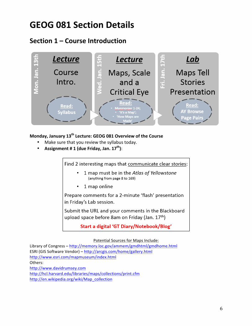
Section 1 – Course Introduction
Monday, January 13th Lecture: GEOG 081 Overview of the Course
• Make sure that you review the syllabus today. • Assignment # 1 (due Friday, Jan. 17th):
Potential Sources for Maps Include: Library of Congress – http://memory.loc.gov/ammem/gmdhtml/gmdhome.html ESRI (GIS Software Vendor) – http://arcgis.com/home/gallery.html http://www.esri.com/mapmuseum/index.html Others: http://www.davidrumsey.com http://hcl.harvard.edu/libraries/maps/collections/print.cfm http://en.wikipedia.org/wiki/Map_collection

7
Wednesday, January 15th Lecture: Maps, Scale and a Critical Eye • Read Monmonier (course book) p. 1-‐24 • Read ‘It’s a Map’ .pdf (this is very quick) • Read ‘How Maps are Made’ .pdf
Friday, January 17th Lab: Present Assignment #1
• Upload your map links AND comments by 8am in Blackboard • Browse the Atlas of Yellowstone and be prepared to discuss the following (during our
lab presentations of the AY and online maps):
1. What kinds of data and what kinds of information are presented in this Atlas? Can you identify maps with quantitative versus qualitative data? Which maps effectively mix both quantitative and qualitative data?
2. What other graphics are included in each page pair? (find examples of spatial data versus non-‐spatial data)
3. Did the authors and cartographers exclude particular topics? What is missing?
4. How transparent are the authors, cartographers and editors regarding their cartographic choices? Do they explain what they left out or emphasized and why?
Readings for Next Wednesday, January 22nd:
• ‘Map Use, Ch. 1’ by Kimerling et al. (Blackboard) • ‘Elements of Map Projections’ by Slocum et al. (Blackboard)