
GEOFFREY PAYNE & ASSOCIATES Regulatory Framework for...
65
GEOFFREY PAYNE & ASSOCIATES Regulatory Framework for affordable shelter The Case of Dar es Salaam, Tanzania Lusugga Kironde March 2004 J.M. Lusugga Kironde holds a Masters Degree in Urban Studies, and a Doctorate in Land Economics. He has researched, lectured, consulted and published extensively on matters of land, property and urban development and management in developing countries, partucularly urban Tanzania. He is currently an associate professor in land and urban economics at the University College of Lands and Architectural Studies (UCLAS) in Dar es Salaam, Tanzania. He is also managing director of a private firm of property consultants. [email protected]
Transcript of GEOFFREY PAYNE & ASSOCIATES Regulatory Framework for...

GEOFFREY PAYNE & ASSOCIATES
Regulatory Framework for affordable shelter
The Case of Dar es Salaam, Tanzania
Lusugga Kironde
March 2004 J.M. Lusugga Kironde holds a Masters Degree in Urban Studies, and a Doctorate in Land Economics. He has researched, lectured, consulted and published extensively on matters of land, property and urban development and management in developing countries, partucularly urban Tanzania. He is currently an associate professor in land and urban economics at the University College of Lands and Architectural Studies (UCLAS) in Dar es Salaam, Tanzania. He is also managing director of a private firm of property consultants. [email protected]

2
CONTENTS
List of Tables ...................................................................................................................... 4 List of Figures ..................................................................................................................... 4 List of Boxes ....................................................................................................................... 5 Glossary of Acronyms ....................................................................................................... 5
EXECUTIVE SUMMARY ..................................................................................................................... 6 THE CONTEXT ..................................................................................................................................... 9
The nature of the local land and housing market ........................................................... 9 Indication of the gap in the supply of formal land/housing ......................................... 10 The policy environment ................................................................................................... 12
THE REGULATORY FRAMEWORK ................................................................................................ 14 Introduction ...................................................................................................................... 14 Overview of the regulatory framework in Tanzania ...................................................... 14 Planning Regulations ....................................................................................................... 15 Planning standards .......................................................................................................... 16
Standards for utilities .................................................................................................................... 20 Exclusion of land considered unsuitable for development ........................................................... 20
Administrative procedures .............................................................................................. 21 Declaration of an area to be a planning area and preparation of a planning scheme .................... 21 Land acquisition and compensation .............................................................................................. 23 Access to land by households ....................................................................................................... 24 Building plans and building permit ............................................................................................... 25
General evaluation of the regulatory framework in Tanzania ...................................... 25 Objectives of the research .............................................................................................. 27 Research methods ........................................................................................................... 27
Selection of the case study area, Kinyerezi ................................................................................... 28 Background to Kinyerezi .............................................................................................................. 29 Administration of the questionnaire .............................................................................................. 30
Results ................................................................................................................................................... 31 Findings from official sources ........................................................................................ 31
Administrative Procedures adopted for Kinyerezi ........................................................................ 31 Elements of costs of the Kinyerezi Planning Scheme ................................................................... 31 Planning standards adopted for Kinyerezi .................................................................................... 32 Regulations adopted for Kinyerezi ............................................................................................... 33
Findings from the fieldwork ............................................................................................ 34 The question of compensation ...................................................................................................... 34 Kinyerezi Planned Area ................................................................................................................ 36 Unplanned Kinyerezi .................................................................................................................... 41
Evaluation of the regulatory framework as applied to Kinyerezi ................................. 45 Comparing the planned to unplanned Kinyerezi ........................................................... 46
RECOMMENDATIONS FOR ACTION ............................................................................................ 48

3
Long term .......................................................................................................................... 48 Administrative procedures ............................................................................................................ 48 Standards ....................................................................................................................................... 49 Regulations .................................................................................................................................... 49
Short term ......................................................................................................................... 50 ADDRESSING CONSTRAINTS TO CHANGE ................................................................................ 51
Reactions from the gatekeepers ..................................................................................... 51 Changes proposed from the RF Project ........................................................................................ 51
Recommendations included in the proposed Town and Country Planning Act ........ 56 Considerations for the future .......................................................................................... 56 Conclusions ...................................................................................................................... 57 Bibliography ..................................................................................................................... 59
Annexes ................................................................................................................................................ 61 Annex 1: Summary of Use Groups and Use Classes under the Town and Country Planning (Use Classes) Regulations 1960 as amended in 1993 .................................. 61 Annex 2: List of officials Interviewed ............................................................................. 64 Annex 3: List of other stakeholders interviewed .......................................................... 65 Annex 4: Regulatory matrix table for Kinyerezi ............................................................ 66 Annex 5: Questionnaire for Plot Owners, Kinyerezi Planned Area ............................. 70 Annex 6: Questionnaire for Plot Owners, Kinyerezi Unplanned Area ......................... 75 Annex 7: List of attendants, Workshop on “The Regulatory Framework for Affordable Shelter” held in Dar es Salaam, Tanzania, 12th February 2002 ................. 81
4
List of Tables Table 1: Recorded demand for surveyed and allocated plots, Dar es Salaam 1990-2001 10 Table 2: Average household size in Dar es Salaam and Tanzania 11
Table 3: Tenure households of occupant households, Dar es Salaam 1990 12
Table 4: Space Standards for residential areas under the 1997 Regulations 17
Table 5: Minimum building lines and setbacks 17
Table 6: Minimum Plot Coverage and Plot ratio for detached houses 17
Table 7: Standards for carriageways and rights of way 18
Table 8: Minimum standards for health facilities 18
Table 9: Standards for educational facilities 18 Table 10: Standards for recreational facilities 19 Table 11: Standards for active recreation activities 19 Table 12: Standards for passive recreation activities 19 Table 13: Space standards for public facilities 19 Table 14: Standards for public facilities by population size 20 Table 15: Typical steps in making legal land available 21 Table 16: Time schedule envisaged by the Town and Country Planning Ordinance 1956 with respect to planning schemes
22
Table 17: Typical steps followed when land for allocation is available 24 Table 18: Procedures in the Kinyerezi Planning Scheme 31 Table 19: Elements of costs of the Kinyerezi Planning Scheme 32
Table 20: Planning profile for Kinyerezi neighbourhood centre 33 Table 21: Typical conditions and charges on getting an offer for a right of occupancy in the Kinyerezi Planning Scheme
33
Table 22: Household monthly income, Kinyerezi planned area 36 Table 23: Ways of accessing land in Kinyerezi planned area 37 Table 24: Time lapse between the completion of the survey and the issuance of letters of offer
37
Table 25: Opinions on plot sizes owned 38 Table 26: Ownership of other pieces of land 38 Table 27: Reasons for not having title 38 Table 28: Opinion on Land Rent 39 Table 29: Reasons for not having a building permit 40 Table 30: Reasons for selling land, Kinyerezi planned area 40 Table 31: Land sizes owned in the unplanned area 41 Table 32: Decreasing sizes of land purchased 42 Table 33: Land sizes per house in select informal settlements in Dar es Salaam 42 Table 34: Modes of accessing land, Kinyerezi unplanned area 43 Table 35: Duration of negotiations to purchase land in unplanned Kinyerezi 43 Table 36: Witnesses to the sales of land 43
List of Figures Figure 1: Location of case study area: Kinyerezi, Dar es Salaam 29 Figure 2: Kinyerezi Centre, Shops under construction 30 Figure 3: Housing in unplanned Kinyerezi showing good quality buildings. 42 Figure 4: Phased Construction due to fluctuating incomes, Kinyerezi unplanned area 45 Figure 5: Locally produced bricks ready for construction, Kinyerezi unplanned area 45

5
List of Boxes Box 1: Key provisions for the regulatory framework in Tanzania 14 Box 2: Views of Mr JJ of Mnembwe Area, Kinyerezi 35 Box 3: The Case of Mr GZ 35 Box 4: Offer of Right of Occupancy over land rejected 35 Box 5: Living in Anxiety after land has been surveyed 36 Box 6: The space standards for residential areas in Tanzania 52 Box 7: Why a revised regulatory Frameworks is good for appropriate urban land management
57
Glossary of Acronyms ALAT Association of Local Authorities of Tanzania AQRB Architects and Quantity Surveyors Registration Board CBO Community-based organisation CIUP Community Infrastructure Upgrading Project DAWASA Dar es Salaam Water and Sanitation Authority DCC Dar es Salaam City Council ESRF Economic and Social Research Foundation EPM Environmental Planning and Management FACEIT Front Against Corrupt Elements in Tanzania GN Government Notice, General Notice HBS Household Budget Survey HSD Human Settlements Department ILO International Labour Organisation IST Institution of Surveyors of Tanzania KIJICO Kijitonyama Community Organisation MLHSD Ministry of Lands and Human Settlements Development MLHUD Ministry of Lands, Housing and Urban Development NCC National Construction Council NGO Non-governmental organisation NHC National; Housing Corporation NLUPC National Land Use Planning Commission NOC Certificate of no objection NSSF National Social Security Fund P.O. Post Office RoW Right of Way SMD Survey and Mapping Department SONGAS Songosongo Gas Project TAMWA Tanzania Media Women Association TCCIA Tanzania Chamber of Commerce and Agriculture TCPO Town and Country Planning Ordinance 1956 TP Town Planning TPAT Town Planning Association of Tanzania TSHS Tanzania Shillings UASU Urban Authorities Support Unit UCLAS University College of Lands and Architectural Studies UPC Urban Planning Committee USD United States Dollars UWSA Urban Water and Sanitation Authority VIBINDO Local acronym for a Youth advancement organisation WAT Women Advancement Trust WEO Ward Executive Officer

6
EXECUTIVE SUMMARY Getting Planned land is a major problem in Dar es Salaam. While between 1990 and 2001, the Dar es Salaam City authorities received 243,473 applications for planned plots, only 8209 were surveyed and allocated. The annual demand over the period is over 20,000 plots, while the annual supply has been under 700, leaving nearly 97 percent of the recorded demand unallocated. Projecting future demand depicts an even bleaker picture. The city of Dar es Salaam had 1,360,000 people in 1988. The population is estimated to be 3,500,000 in 2002. This represents a growth rate of 7.5 percent since 1988. If this growth rate is maintained, the population will be 6,700,000 people in 2010, representing an additional 3,200,000 people. At an average household size of 4.5, this means an extra 710,000 households over the period; or around 79,000 new households per annum for the next nine years. Not all households will be aiming at owner occupation since some 70 percent of Dar es Salaam’s households are tenants. If it is assumed that at least 50 percent of the households will require new land for construction either for owner occupation or for renting out, the demand for plots will be 40,000 annually to meet new land requirements. On the other hand, the supply of planned land has been around 684 plots a year between 1990 and 2001. If this level of supply persists in the future, it will meet under 2 percent of the demand, with the balance having to be taken care of, by the non-formal sector. This non-formal sector is estimated to produce not less that 19,000 plots a year. Shortage of planned land has led to households of all categories getting their land from the informal sector. This has led to the excessive growth of unplanned areas where, according to official statements, over 70% of Dar es Salaam’s population is living. While there are many reasons accounting for this limited supply of planned land, the regulatory framework, that is, administrative procedures, standards and regulations has a lot to do with it. Administrative Procedures set out the paths through which the public authorities and the citizens have to go, to achieve their aim of providing, or acquiring land, so that at the end, the landowners are recognised as legal owners and developers of that land. Planning standards stipulate how the settlement should look like in terms of “quality”, especially plot sizes, infrastructure, and provision for various uses. Planning Regulations are rules etc that allow or disallow activities on the plot or in an area; or prescribe the way the plot can be developed or used. Regulations are usually enacted to prevent what are conceived to be incompatible uses or developments considered to be against public interests, or those generating harmful externalities. The regulatory framework in Tanzania is set out in various principal and subsidiary legislation, directives and technical instructions, including those related to land tenure, town planning, land surveying, land acquisition and infrastructure provision. It can be conceived at various levels: the national level, the municipality level and the individual household level. Public authorities have the duty to provide planned land. In order to be able to do so, they must have that land in the first instance. Legislation and practice have set down the procedures followed by public authorities to make land available to households. These procedures are characterised by long bureaucracies. Over seven years can elapse between the identification of an area for implementing a planning scheme to the time letters of offer for a Right of Occupancy are issued; with each step having its own sub-steps. This approach envisages that the public authorities acquire land from existing occupiers and then plan and survey it with free reign. A major stumbling block in this process is the unpopularity of, and lack of finance to pay compensation. Planning standards regulate for the provision of large land lots and wide roads thus limiting the number of plots realisable in any planning scheme. Over three and half years can be expected to elapse between the availability of land for allocation and the issuance of a certificate of title. Major impediments can include inability to prepare deed plans, lack of stationery, queries related to procedures of allocation, history of the plot, and conflicts (such as those related to compensation). In practice, many years elapse between allocation and getting a certificate of title

7
Once allocated regulations stipulate how and when the land should be developed and put to what use. Subdivision, assignment or transfer without the consent of the Commissioner for Lands is not allowed. Transfer of the allocated land without substantial developments will not attract consent. The recipient has also to pay various fees and an annual land rent, and has to surrender that land to the Commissioner where he/she fails to develop this land. The Commissioner can revoke the offer or title where development conditions are not met. The regulatory framework was developed and passed during the Colonial and days, although there have been changes since independence. Nevertheless, there has not been a regulatory audit to evaluate the costs of adhering to the existing framework. What is clear however is that in view of the failure of public authorities to provide planned land to land seekers, both low and high income households in Dar es Salaam have resorted to getting their land requirements from the informal land sector which appears to work fast. A major objective of the research was to evaluate the impact of the regulatory framework on the availability of formal land particularly for low-income households. The question that the research sought to address was whether it was possible, to lower the cost of access to legal land. This entailed making an audit of the regulatory framework. An area in Dar es Salaam called Kinyerezi was selected for this research. An official planning scheme has been implemented in this area since the early 1990s. The aim was to document and evaluate the steps that this planning scheme has gone through from inception to allocation of land to households. This was compared to what was happening in an unplanned area in the vicinity of the planned area. In terms of administrative procedures, the Kinyerezi planning scheme went through the steps shown in the Table below. Year Event 1993 Kinyerezi declared planning area. Negotiations with the local population 1994/95 Preparation of planning schemes 1995 Issue of first set of survey instruction 1996 Valuation for compensation 1996/97 Land surveying completed in some parts 1997 Allocation of land starts 1998 Compensation funds released 1998-2001 Surveying completed in other parts
Compensation yielded a lot of discontent, despite the over US$ 330,000 used for the purpose. Land surveying cost nearly US$ 689,000 for the over 3600 odd plots that were surveyed. In terms of standards large plots were adopted and ranged between 800m2 and 2500m2. In the part that was studied in detail, the plot size adopted was 1800m2 consuming 54 percent of all the land. Roads were the second largest consumer of land with the following provisions: Neighbourhood collector roads, 30m Right of Way (RoW); secondary collector roads, 20m RoW; access roads, 10m RoW; and access paths and cul-de-sacs 10m and 5m RoW. Roads consumed 22.4 percent of the land in the planning scheme. A reduction of the standards of land lots to 288m, and the roads to half of the allowed for standards would have yielded 15,000 plots instead of the 3600 that were realised. In terms of regulations, the offers for a right of occupancy to land in the study area carried conditions restricting the use to which the plot can be put to residential purposes. Subdivision or assignment was prohibited. Building had to be completed in three years of the offer. The building itself was to be in permanent materials and building plans were to be submitted for approval by the Dar es Salaam City Council, within six months of the offer. The recipients were required to pay a number of fees and an annual land rent. The plots were put to various economic activities, despite the provisions in the offers.

8
From the field survey, it was found that most households in planned Kinyerezi had low income. A third said they lived at subsistence level. The three major ways of getting land were allocation as a flood victim, purchase before the area was planned, and inheritance. Only 4 percent got land as normal applicants. Over a third thought their land was too small but over half though the size was just about right. Nearly 40 percent had other land within or without Kinyerezi. Over half were able to get letters of offer within six months of completion of land surveying but others had to wait for a longer period. Some 16 percent had no offers four years after land had been surveyed. Only 4 percent had Titles to their land. The largest proportion thought land rent was too high. Plot development was very slow, presumably because of lack of development finance. Only 2 percent of the households carried a building permit. Over half did not know that a permit was required. Some recipients sold their land due to inability to pay land rent or to develop the plot. The system of selling land was simple enough, though it is not encouraged or supported by the Government, and transfer of land from the original recipient is very difficulty, and not allowed where land is undeveloped or poorly developed. In the unplanned part, residents were equally poor. Their land lots were large since the area was still very much rural, but the plots sizes in half of the cases were smaller than those in the studies planned area. Access to land was through purchase in over half of the cases, and through inheritance in a third of the cases. The process of buying land can be accomplished within a week. Local leaders witness these sales. It is difficult to convert land acquired in the unplanned area into legality since land must be surveyed in the first place. In this study area 86 percent of landowners had not surveyed their land. Over 80 percent of the respondents did not know that their land was subject to any regulations and 98 percent did not carry a building permit. The conclusion of the study is that administrative procedures and planning standards increase the cost of, and inhibit the supply of planned land. Recommendations to public authorities include the streamlining the procedures and decentralising powers from ministerial to lower levels, encouraging households to submit their own planned land use schemes for approval, and reducing standards to increase the supply of land from any given scheme. These proposals have so far not been adopted, and it is further recommended that besides continued advocacy, changes in the regulatory framework need to be hooked onto a major national programme such as the Poverty Reduction Strategy. The Town and Country Planning Ordinance is currently under review and some proposals from the regulatory framework project are under consideration. If these are adopted and put in practice, Tanzania may experience the lowering of the cost of access to legal land, taking more of low-income households on board, and reducing unplanned development.
9
THE CONTEXT
The nature of the local land and housing market Ideally, public authorities, that is, central or local governments or their agencies, are supposed to supply or enable the supply of land for orderly urban development. This is implied in Tanzania’s Town and Country Planning Ordinance of 1956 which provides for the declaration of planning areas and which forbids development in a planned area without the permission of planning authorities. The practice has developed in Tanzania that a would-be developer should go to the public authorities to be allocated land for undertaking the earmarked development. For most households, this is residential housing. However, getting planned land is a major problem in Dar es Salaam. As a result, land seekers have been looking at other options, mainly the informal land sector, to get land for their needs. This has developed into what is generally known as unplanned areas, the development of which has increased tremendously in recent years. It is calculated that people who live in these unplanned areas exceed 70 percent of the total population of Dar es Salaam (Kombe and Kreibich, 2000). The number of unplanned areas has increased from 40 in 1990 to over 100 in 2002, according to the data collected by the Community Infrastructure Upgrading Project (CIUP, 2002). Both the Land Act 1999 and the National Human Settlements Policy of 2000 realise that removing unplanned settlements is no longer a viable option. The range of land and housing supply options available to households can be divided into two major groups: Formal and non-formal. The latter includes informal, customary and quasi-customary tenures. The legal status of customary tenure in and around Dar es Salaam is vague. The Colonial government in the then Tanganyika issued a proposal in Government Circular No. 4 of 1953, which stated that once an area is declared to be a planning area, the customary tenure in such land ceases. This proposal was not translated into law. In the case of Nyagwasa v. Nyirabu (Civil Appeal no. 14 of 1985), the Court of Appeal held that customary tenure in land persisted after the declaration of an area to be a planning area, until these rights are properly extinguished in law (Fimbo, 1992). In December 1998, in the case of Mwalimu Omari and Ahmed Baguo v. Omari Bilal (Civil Appeal 19 of 1996), the Court of Appeal ruled that no person has a right to own urban land under customary law. The Court ruled that customary tenure applied only in rural areas, or to registered villages within the urban areas. Anyone who owns land in an urban area without a granted right of occupancy was a squatter without title. This ruling turns the majority of urban landowners into squatters. It also ignores the situation where urban boundaries are expanded outwards, encompassing customary land at the periphery. Nevertheless, people are continuing to acquire and develop land without reference to public authorities and many believe that they can invoke customary tenure. The Land Act 1999 has provisions to validate much of the urban land acquired otherwise than through the grant of a right of occupancy by turning such owners into licensees. These provisions have so far not been applied. The Land Act 1999 refers to customary tenure and other informal tenures in urban areas, but does not offer definite definitions. For the purpose of this study, we have opted to regard all land accessed otherwise than through a granted right of occupancy to be informal tenure. Formal land is equated to planned land. It is land which will have, in the first place, been acquired by public authorities and then planned and (usually) surveyed. Sometimes, it may be serviced, or has land set aside for institution of services in the future. Formal land is usually allocated directly to the users by either local authorities or the Ministry of Lands. There are cases when formal land can be bought from those to whom it is allocated in the

10
first place, although this is highly discouraged by the government, which will not allow the transfer of such land unless it is substantially developed. Informal land is equated to unplanned land. This comes about as a result of the failure to enforce development control in areas that are already declared to be planning areas, or the extension of urban boundaries to incorporate areas that were already growing unplanned, outside the urban boundaries. Informal land can be obtained by way of allocation by those who claim to own it or by village authorities; it can be occupied without anybody’s permission, or can be purchased. Increasingly, informal land is acquired through purchase. Landowners subdivide land and make it available to land seekers usually without regard to plans which the public authorities may hold.
Indication of the gap in the supply of formal land/housing Table 1 shows the applications for and output of surveyed and allocated plots in Dar es Salaam between 1990 and 2001. Table 1: Recorded demand for, and surveyed and allocated plots, Dar es Salaam 1990-2001
Year No of applications Surveyed and allocated plots
percent applicants unallocated
1990 30,000 1490 94.6 1991 31,734 1256 96.0 1992 32,780 203 99.4 1993 21,370 506 97.6 1994 18,670 201 98.9 1995 29,900 1372 95.4 1996 28,782 1027 96.4 1997 21,876 326 98.5 1998 16,497 701 95.7 1999 6,290 609 90.1 2000 2,263 310 86.6 2001 3,311 208 93.7 Total 243,473 8209 96.6
Source: Dar es Salaam City Council and the three Municipalities records Thus while between 1990 and 2001, Dar es Salaam received 243,473 applications, only 8,209 lots were surveyed and allocated. The annual demand over the period, based on registered applications is over 20,000 plots, while the annual supply has been under 700, leaving nearly 97 percent of the recorded demand unfulfilled. Since registered applications have been falling, the demand, based on demographic estimates of household formation (as calculated later on below), is higher. This means a larger shortfall than is reflected in the table. The picture of high demand and low supply is also reflected at the national level. While the annual registered demand for formal land is 150,000 plots, the supply has been an average of 8,000 surveyed plots annually for the ten years 1991-2001(Tanzania, 2001) indicating an annual shortfall of about 95 percent. Not only has the output of surveyed plots been falling over the years, but also applications have gone down as well, being a reflection of the experience that the chances of getting an allocation from public authorities are remote. The recourse for many is to acquire land from the informal sector, or to buy land from those to whom it is first allocated.

11
In recent years, planned plots have been allocated mostly to people with problems e.g. those being required to relocate. This means, 97 percent of the demand, as evidenced by registered applications, is not being met through planned development and this has led to most households, in both high and low income categories, government officials, academicians, and businessmen, getting land from the informal sector and building in unplanned areas. Figures provided in Table 1 give an indication of the gap between the demand and supply of formal land in the past decade or so. The gap may even be wider in the future if steps are not taken to increase supply. The future demand can be estimated on the basis of population and household growth rates. The average household size in Dar es Salaam was established to be 4.5 persons in 2001, a slight drop from 4.8 persons in the early 1990s (Table 2). Table 2: Average household size in Dar es Salaam and Tanzania Years Dar es
Salaam Other urban areas
Rural areas Mainland Tanzania
HBS 1991/92
4.8 4.9 5.9 5.7
HBS 2000 4.5 5.2 5.5 5.4 HBS = Household Budget Survey Source: National Bureau of Statistics (2001), Trends in Poverty and Social indicators: Tanzania 1991/92-2000, A Preliminary Analysis, Dar es Salaam. The population of Dar es Salaam was 1,360,000 in 1988 and is estimated to be 3,500,000 in 2002, indicating a growth rate of 7.5 percent since 1988. If this growth rate is maintained, the population will be 6,700,000 people in 2010, representing an additional 3,200,000 people. At an average household size of 4.5, this means an extra 710,000 households over the period, or around 79,000 new households per annum for the next nine years. Not all households will be aiming at owner occupation since, as pointed out above, the incidence of renting is high in Dar es Salaam. If we assume that at least 50 percent of the households will require new land for construction either for owner occupation or for renting out, the demand for new plots will be 40,000 annually to meet new requirements. On the other hand, the supply of planned land has been around 684 plots a year for the past twelve years (Table 1). If this level of supply persists in the future, it will meet under 2 percent of the demand, with the balance having to taken care of by the informal sector. It is difficult to estimate the supply of informal land over the years but given the rapid development of unplanned areas, it may be safe to assume that much of the unmet demand submitted to the formal sector, gets accommodated in the informal sector. This crude assumption means that the informal sector supplies between 18,000-19,000 plots in Dar es Salaam annually. In fact the supply may be higher since there is some evidence that many land seekers do not register with public authorities. In some of the old unplanned areas, densities of between 200 and 370 people per hectare have been recorded (MLHUD, 1997) There has not been a recent study on the nature of housing needs in Tanzania and in Dar es Salaam, although the analysis of the August 2002 census figures will shed some light on housing conditions and income. Almost all the housing (98 percent) is provided by the private sector using self-mobilised income. There is no formal housing finance in Tanzania. A negligible supply of housing is provided by the National Housing Corporation, the Government and Parastatal Organisations although the latter are moving out of housing supply by disposing of the stock that they have.

12
The 1988 census indicated that the majority of urban dwellers are tenants. A study carried out some two years later in 1990 indicated that owners make up 27 percent of households, while tenants are 73 percent (Table 3) (Hoek-Smit, 1991). The number of tenant households can only have increased in the past decade.
Table 3: Tenure households of occupant households, Dar es Salaam 1990 Tenure characteristics of the households Percent households
Owner households occupying house alone 14 Owner households sharing unit with renters 13
Unit renters 17 Room renters 56
Hoek-Smit (1991), The urban housing sector in Tanzania, Research report prepared for the Ministry of Regional Development and Local Government, Tanzania, and the World Bank.
The Government considers an occupancy rate of more than 2 persons per room to constitute overcrowding. Using this measure, 34.4 percent of all households in Dar es Salaam live in overcrowded conditions. Most housing is constructed without reference to public authorities even in planned areas. Only 35 percent of all houses in urban Tanzania are in compliance with the regulations. The cumulative shortfall of housing units is estimated to be 2,200,000 in 2000 (Tanzania, 2000).
The policy environment The policy environment is moulded by the roles played by the central and local governments and the relation of these with other actors and stakeholders. There are two kinds of government levels in Tanzania - the central government and local authorities. Local authorities comprise of urban authorities (city, municipal and town councils) and rural authorities (district councils). The supply of planned land is in the realm of public authorities. According to the past and current land tenure legislation, all land in the country is vested in the President. The role of the central government with regard to land and housing is to: • Stipulate policy and to propose and enforce legislation and norms • Acquire land from its current occupiers as and when required for planning purposes • Prepare and approve planning (i.e. land use) schemes over areas • Survey the land and to approve the surveyed plans for land • Allocate planned land • Issue certificates of title and to register titles and encumbrances to land • Enforce development conditions • Revoke titles to land where development conditions have been breached, or for any
other reason • Implement policy with regard to housing provision Most powers over land are vested within the central government. These include the approval of all planning and cadastral survey schemes and signing of certificates of title to land. Land acquisition must be sanctioned by the central government. Land allocation is shared between the central government and local authorities. Land Allocation Committees are supposed to be formed at various levels of government. Issuance and registration of title are within the Ministry of Lands. Enforcement of development conditions is done by local authorities, but change of use, and revocation of title in the case of failure to meet development conditions, can only be sanctioned by the Ministry of Lands.

13
The provision of service infrastructure is under different institutional arrangements from land use planning and land allocation. This, coupled with lack of resources, has resulted in many planned areas getting allocated and developed without the usual infrastructure. There is no organised private sector dealing with housing and real estate development in Tanzania. Private households are the major providers of housing, and do this on a small scale, incremental basis. Since there is no formal housing finance, the putting up of a property to completion can take over 10 years.

14
THE REGULATORY FRAMEWORK Introduction Although there are many variables that affect the cost of access to shelter, this study is restricted to the regulatory framework related to access and planning of land. It therefore excludes buildings and building regulations for example. The regulatory framework is conceived under three major categories i.e., planning regulations, planning standards, and administrative procedures. Planning Regulations are rules that allow or disallow activities on the plot or in an area; or prescribe the way the plot can be developed or used. Regulations are usually enacted to prevent what are conceived to be incompatible uses or developments considered to be against public interests, or those generating harmful externalities. They include land use/zoning controls, plot-use restrictions, and building set back. Planning standards stipulate how the settlement should look like in terms of “quality”. They include plot minimum sizes, minimum frontages and minimum depths, and road widths, and provisions for public and social and economic uses. Administrative Procedures set out the path through which the public authorities and the citizens have to go to achieve their aim of providing, or acquiring land, so that at the end, the landowners are recognised as legal owners and developers of that land. In the following paragraphs, an overview of the regulatory framework in Tanzania is provided, highlighting those provisions that are documented and are frequently applied.
Overview of the regulatory framework in Tanzania The regulatory framework in Tanzania is set out in various principal and subsidiary legislation, and directives and technical instructions. The most important of these are shown in Box 1. Box 1: Key provisions for the regulatory framework in Tanzania Principal Legislation: Land Ordinance, 1923 (till May 2001) Land Act, 1999 (from May 2001) Town and Country Planning Ordinance (Cap 378) 1956 Land Registry Ordinance (Cap 70) 1923 Land Registration Ordinance (Cap 334), 1954 Land Surveying Ordinance 1957 (Cap 390) Registration of Documents Ordinance (Cap 117) 1921 Land (Law of Property and Conveyancing) Ordinance (Cap 114) 1923 Land Acquisition Act 1967 Water Utilisation (Control and Regulation) Act of 1974, as subsequently amended Local Government (Urban Authorities) Act, 1982 Public Health (Sewerage and Drainage) Ordinance, Cap 336, 1950 Subsidiary Legislation: Under the Land Act 1999
Land (Compensation Claims) Regulations, 2001 Land (Management of the Land Compensation Fund) Regulations, 2001 Land (Fees) Regulations, 2001

15
Land (Schemes of Regularisation) Regulations, 2001 Under the Land Survey Ordinance (Cap 390) 1957
Land Survey (General) Regulations 1959 Land Survey and Surveyors Regulations 1959 Land Survey (General) (Amendment) Regulations 1990.
Under the Town Planning Ordinance (Cap 378) 1956 Use Classes Regulations 1960 as amended in 1993 Application for Planning Consent Regulations 1960 Town and Country Planning (Appeals) Regulations 1961 Town and Country Planning Modification of Planning Schemes Regulations 1964 Urban Farming Regulations Order 1993 Town Planning Space Standards Regulations 1997 Public Recreation Grounds (Allocation, Development Conditions, Management and Control) Regulation 1994 Town and Country Planning (Amendment of Use Classes) Regulations 1993
Directives and Technical Instructions: Technical Instruction no 5 of 1977 Distribution of Approved Layout Technical Directive No. 1 of 1989 Design of Layouts and other related matters Technical Instruction No 3 of 1991 Standards for cemeteries and waste disposal Technical circular No 14 of 1994 On legal requirements regarding planning consents and building permits in urban areas Technical circular No 1 of 1995 Conditions for the subdivision of urban plots in Tanzania Technical circular No. 1 of 1991, Standards for Market and small business areas
The regulatory framework can be conceived at various levels: the national level, the municipality level and the individual household level. The declaration of an area to be a planning area, the sanctioning of change of use, the approval of planning schemes, the application of land acquisition and compensation powers if necessary, the approval of surveying instructions, the approval of cadastral surveys, the issuance of title to land and land registration are all done at the national level. The major agent here is the Ministry of Lands and Human Settlements Developments (MLHSD) (formerly, Ministry of Lands, Housing and Urban Development). The relevant legislations include the Town and Country Planning Ordinance of 1956; the Land Acquisition Act of 1967; the Land Survey Ordinance of 1957; the Land Registry Ordinance 1923; and, the Land Act 1999 (which replaced the Land Ordinance 1923 in May 2001). Some powers responsibilities and procedures are also contained in the Local Governments Acts. Some planning schemes are conceived at the municipal level (though approval lies with the Minister). Land is allocated at the municipal level (as well as at the Ministerial level). Approval of development schemes, such as issuance of a building permit as well as enforcement of development controls is done at the municipal level.
Planning Regulations Planning regulations are contained in a number of legislations and directives the most important of which are the Town and Country Planning Ordinance of 1956 and the Land Act 1999 and regulations made under these pieces of legislation; the Township rules (Cap 101), the Land Survey Ordinance, 1957, and various technical circulars and Instructions. The Town and Country Planning Ordinance of 1956 as amended in 1961 is currently the principal legislation in Tanzania providing planning regulations. The Ordinance gives powers
16
to the Minister responsible for Town Planning to declare an area to be a planning area. Once this is done, a land use schedule (planning scheme) must be prepared for the area in question usually within three years of the declaration. The Minister is responsible for the preparation of the development scheme for a planning area. He may delegate his powers to an Area Planning Committee although approval of any planning scheme lies with the Minister. No development is allowed in a planning area without a planning consent given by the area planning committee, which is also responsible for the controlling of development in a planning area. Powers are given in the Ordinance for the preparation of planning schemes in order to: • Provide for reservation areas, zones and sites for various uses for residential, industrial,
commercial, institutional and agricultural uses; • Regulate and control the density of development by limiting the number of buildings
which may be on an area or a plot; or to limit the number and size of plots in any area, and,
• Make provisions for roads, public services and amenities; and the use of land, and regulation of buildings and structures.
The Town and Country Planning (Use Classes) Regulations of 1960 as amended in 1993 classify the various uses allowed in planned areas, and when a land seeker is given a letter of offer for a right of occupancy permissible uses will usually be stated. There are 22 Use groups (Group A to W), and under each group, there are several use classes as summarised in Annex 1. Use Group “A” is the most relevant for this study. When an applicant is offered a right of occupancy, there is usually a restriction that land will be used for residential purposes, Use Group “A”, Use classes (a) and (c). These allow only one dwelling house with the usual outbuilding. Under conditions of a right of occupancy, subdivision or assignment of land is not allowed without the permission of the Commissioner of Lands. The Township Rules prevent the use of building for use classes other than those allowed.
Planning standards Standards for planning schemes are provided for under the Town and Country Planning (Space Standards) Regulations of 1997. The Town Planning Space Standards include sizes for residential areas, building lines and set backs, plot coverage and plot ratios, health and educational facilities, golf courses, passive and active recreation, public facilities by planning levels, public facilities by population size, parking and road width and agricultural show grounds. Standards for residential areas specify the sizes of plots in a planning area. There is a tradition of dividing residential areas into high, medium and low-density areas. In colonial days, this was meant to roughly provide separate areas for native (African), Indian and European residential areas respectively. In modern times, there is a tendency to relate high, medium and low-density areas to low, medium and high-income households respectively. The space standards applicable to residential areas in Tanzania have evolved from directives, circulars, and recommendations made by various officials and in various reports, going as far back as the colonial Township Ordinance 1920. The master plans prepared for various urban areas, starting with the one for Dar es Salaam in 1949, made recommendations for space standards. In both the 1968 and 1979 Master plans for Dar es Salaam, space standards are given as a minimum of 450m2 and a maximum of 1600m2, with an intermediate size of 800m2. Clearly, this is a colonial legacy since colonial administrators were used to enjoying a spacious life style with detached houses usually in one acre plots.

17
During the 1970s and 1980s, the World Bank supported sites and services schemes adopted smaller plot sizes with a minimum size of 288m2, an intermediary size of 500m2 and a large size of 750m2. The argument was that the existing sizes were too large, and that there was need to lower the unit cost of infrastructure and to allow more of the earmarked low income households to afford the price of the plots which was based on the principle of cost recovery. In 1997, the existing information on plot sizes was collected, analysed and deliberated and official space standards regulations were passed by Parliament. These provided for a minimum size of 400m2, an intermediate size of 800m2 and a large size of 1600m2 and above. as is shown in Table 4. Table 4: Space Standards for residential areas under the 1997 Regulations Type of residential area
Plot sizes 1997 regulations (m2)
Plot sizes, Sites & Service Schemes 1970s (m2)
High Density 400-800 288-400 Medium Density 801-1600 500-800 Low Density 1601-4000 Over 750
Building lines and setbacks stipulate the location of the building on the plot and how much space should be left from the borders of the plot. The prevailing building lines and set backs are shown in Table 5. This means that on a 400m2 high-density plot, 145m2 is devoted to setbacks alone.
Table 5: Minimum building lines and setbacks Type of
residential area Setbacks
Front (m)
Sides (m) Rear (m)
High density 3.0 1.5 2.0 Medium Density 3.0 3.0 5.0 Low density 5.0 4.0 10.0
Plot coverage and plot ratios are meant to limit the size of the building and to control the density of buildings in an area. Current provisions are shown in Table 6. Thus even in a high-density area usually meant for low-income households, the building can only cover 40 percent of the plot.
Table 6: Minimum Plot Coverage and Plot ratio for detached houses Type of
residential area Plot coverage Plot ratio
High Density 40 percent 0.40 Medium Density 25 percent 0.25 Low Density 15 percent 0.20
Land for access is usually provided for in planning schemes. Standards are specified for various categories of carriageways and rights of way. The prevailing standards are as shown in Table 7. Roads consume between 20-30 percent of the land in a typical planning scheme.

18
Table 7: Standards for carriageways and rights of way Type of road Right of Way (ROW)
(m) Carriageway (CW) (m)
Trunk road 60.0-70.0 12.0-15.0 Primary distributors 30.0-40.0 7.0-10.0 District distributors 20.0-30.0 7.0-10.0 Local distributors 15.0-20.0 5.0-7.5 Access roads (shopping areas) 20.0 10.0 Access roads (industrial areas 18.0-20.0 7.0-10.0 Access roads (residential areas) 10.0-20.0 5.0-7.0 Local distributors (residential areas)
10.0-20.0 6.0
Rural roads 15.0-20.0 4.5-7.5 Pedestrian access 10.0 2.0
In a typical planning scheme for residential land uses, a dispensary or clinic is usually provided for. Some 3,500 to 5000m2 is the recommended minimum for a population of between 7000 and 10,000. Higher levels of health facilities need more land (see Table 8) Table 8: Minimum standards for health facilities Type Beds per unit
or facility Population per unit or facility
Gross area per person
Plot size
Dispensary or clinic
- 7,000-10,000 0.5m2 3,500-5,000m2
Health centre/MCH
20-40 10,000-25,000 2.5m2 0.5-1.0 ha
Hospital 100-400 100,000-120,000 2.5m2 2.5-10.0 ha Referral Hospital 400-1,000 150,000+ 2.5m2 10.0-40.0 ha
Education facilities are considered an important element of any planning scheme. Provisions are usually necessary for a nursery and primary school in a neighbourhood. The standards for education facilities are as shown in Table 9. Table 9: Standards for educational facilities Type Planning
unit Population per unit (students)
Gross area per person (m2)
Plot size
Nursery school Neighbourhood
40-60 30 1200-1800m2
Primary school Neighbourhood
280-1120 40 1.5-4.5 ha
Secondary school District 320-640 40 2.5-5.0 ha Polytechnic District 300-500 100 3.0-5.0 ha Educational centre District 300-600 40 1.2-2.5 ha College 300-6600 50 1.5-3.0 ha University College 600-800 100 8.0-40.0 ha
Another important land use that is usually provided for in a planning scheme is land for recreation. At a neighbourhood level, it is considered necessary to have an open space as well as a neighbourhood park. The provisions for recreational facilities under the space standards regulations are as shown in Table 10.

19
Table 10: Standards for recreational facilities Type of facility Planning level Population/unit Gross area per
person (m2) Plot size
Open spaces Neighbourhood
100-150 5.0-10.0 500-1500m2
Neighbourhood park Neighbourhood
3,000-5,000 2.0-5.0 0.6-2.5 ha
Recreational park Community 10,000-20,000 1.5-2.5 1.5-4.0 ha Stadium District/town 100,000-
120,000 1.5-2.0 15.0-24.0
Park District/town 100,000-120,000
1.0-2.0 10.0-24.0
Besides the general provisions for recreational facilities, standards required the accommodation of active and passive recreation activities. Active recreation activities include sports grounds and playing fields. Passive recreation activities include private and public parks, public gathering grounds, green belts, botanical or other gardens, urban squares and scenic sites. The standards for the provision of these at neighbourhood, community and district levels is as shown in Tables 10 and 11. Table 11: Standards for active recreation activities
Type of activity
Gross area per 1000 persons
Neighbourhood level
Community level
District level
Children play area
0.2-0.4 ha 1.0-2.0 ha 4.0-8.0 ha 2.0 ha
Play fields 0.5-1.0 ha 2.5-5.0 ha 10.0-20.0 ha 50.0 ha Sports fields 1.0-1.5 ha 5.0-8.0 ha 20.0-30.0 ha 100.0 ha
Table 12: Standards for passive recreation activities
Type of activity Gross area per 1000 persons
Neighbourhood level
Community level
District level
Picnicking 250-500m2 1.0-2.0 ha 5.0-10.0 ha 15.0 ha Zoo or arboretum 0.5-1.0 ha 2.5-5.0 ha 10.0-15.0 ha 60.0 ha Camping 2.0-5.0 ha 10.0-25.0 ha 40.0-100.0 ha 240.0 ha
The provisions for recreational facilities need to be flexible to avoid over-provision since the same piece of land can be used for various types of recreation. Public facilities that are usually provided for include markets shopping areas or commercial centres, service trade areas, areas for religious activities, community halls and cemeteries. Again these are considered at neighbourhood, community and district level as shown in Table 13. Table 13: Space standards for public facilities Type of facility Gross area per
person (m2) Neighbourhoo
d level Community
level District
level Market 0.4-0.5 1200-2500m2 0.5-1.5 ha 4.0 ha Shops** 0.8-1.0 250-500m2 1.0-2.0 ha 8.0 ha Public areas/buildings
0.25-0.5 800-2500m2 0.32-1,5 ha 82.5 ha
Service trade 0.4-1.0 2000-5000m2 0.16-0.5 ha 3.0 ha Religious areas 0.3-0.4 - 0.2-0.4 ha 0.8 ha Library 0.15-0.2 - 0.15-0.2 0.6 ha

20
Community halls 0.2-0.4 - 0.2-0.8 ha 2.0 ha Cemetery sites 0.5-1.5 ha 2.0-6.0 ha 12.0 ha ** 5-10 plots within the centre and at other corner plots
There are also provisions for public facilities that may be pertinent to the neighbourhood level on the basis of population. These include service industry, hotel sites, commercial areas, bars and restaurants, cinema halls, petrol stations and industrial areas as shown in Table 14.
Table 14: Standards for public facilities by population size Type of facility Gross area
(m2) Population
Unit Plot size
Service industry 0.3 100,000 3.0 ha Hotel sites 0.2 100,000 2.0 ha Commercial zone
0.3 100,000 3.0 ha
Bar/ restaurant 0.4 3,000+ 1,200m2 Cinema Halls 0.3-1.0 400-800 seats 1,200-8,000
m2 Petrol Station 7,000-10,000 3,000-4,500
m2 Industrial plot 4,000-8,000
m2 A general observation is that the space standards provide for fairly large land parcels for the various requirements. This means that the number of residential plots that can be realised from a given planning scheme are low, thus contributing little to easing the shortage of planned land. Large land plots are also expensive to service and contribute to urban sprawl. Besides regulations limit the area that can be developed into buildings, thus leading to the under-utilisation of land. Standards for utilities Except for road sizes, there are no specific standards for infrastructure enforced. Roads are meant to cater for other infrastructure such as water, sewer, drain, electricity and telecommunications networks. However, in most planning schemes in Tanzania, infrastructure is missing and plots are allocated and developed without any of the standard infrastructure. This may keep the initial cost of access to the plots low, but it has a negative psychological impact on low-income households who realise that they have to meet the cost of instituting infrastructure themselves. Without co-ordination, this becomes very expensive for the individual landowner. In any case, large plots are expensive to service, whenever a decision is made to do so, whether this is done by the public authorities or by the private landowners. Thus there do not appear to be standards set down for water, drains, waste disposal or electricity supply, that are related to the legality or otherwise of planning a neighbourhood. Although the service providers have their own technical standards related to say the type of materials to be used, the depth at which pipes must be buried under different circumstances, and the legal process of getting hooked to the service. Exclusion of land considered unsuitable for development One observable aspect of urban development in Tanzania is the occupation, especially by low-income households, of land that is considered to be hazardous. The Land Act 1999 defines hazardous land as land, the development of which is likely to pose a danger to life, lead to the degradation, or environmental destruction, of that or contiguous land. It includes

21
land within 60 metres of a riverbank, shoreline of an inland lake, beach or coast, and land on steep slopes. Development on hazardous land is not allowed. In many official planning schemes, land that is considered hazardous is excluded, although in the absence of planned schemes, such land, in river valleys and on steep terrain is occupied especially by low-income households. While exclusion of hazardous land is sound planning practice, too much land is left out. Based on what low-income households do with that land, much of it could be put to useful development.
Administrative procedures Administrative procedures can be conceived of at the level of the public authorities and of individual land seekers. In order for households to get access to legal land, this land must be available in the first instance. The various steps that authorities go through to provide legal land are shown in Table 15. Relevant legislation include the TCPO, Land Acquisition Act 1967, Land Surveying Ordinance 1957, and the Land Act 1999.
Table 15: Typical steps in making legal land available Step Action Typical Duration 1 Identification of a suitable area 2 Notification of property owners 6 months 3 Declaration of area to be planning area 1 year 4 Valuation of existing interests 1 year 5 Effecting payment of compensation 1-2 years 6 Preparation of Town Planning Scheme 1-2 years 7 Approval of Town Planning Scheme,
UPC 6 months
8 Approval of Town Planning Scheme, Ministry
6 months
9 Land Surveying 1-2 years 10. Approval of survey 1-9 years 11. Letters of Offer* 1-6 months 12. Acceptance 1 month 13. Issuing of Certificate of Title 1- many years
* Entry point into legality Source: Ministry of Lands, Dar es Salaam City Council, Dar es Salaam Municipalities.
Thus, seven or more years can elapse between the identification of an area for implementing a planning scheme to the time letters of offer are issued. Each of the steps shown in Table 15 has its own internal sub-steps that are not shown here. Land surveying, for example, must go through 17 steps, which can take anything from a few months to several years (Silayo, 2002). Declaration of an area to be a planning area and preparation of a planning scheme The TCPO sets out the procedure for preparing general and detailed planning schemes. This is shown in Table 16. In some cases, the law stipulates the time limit in which an action must take place. In most cases however, the law is unspecific, although typical durations are given from a study of a number of planning schemes. The process starts with the declaration of an area to be a planning area and the preparation of a general planning scheme, followed later on by a detailed planning scheme.

22
This procedure is very long and an optimistic period of two years is perhaps the minimum between the declaration of an area and the approval of a planning scheme by the Minister. Besides, it gives most powers to the Minister though the time in which the Minister is required to take action is not specified. Even at the most optimistic implementation, some two years are bound to elapse before a general planning scheme is approved and another two years before a detailed planning scheme is approved. In practise, moreover, the requirement to deposit planning schemes for public inspection is rarely practised. Also, the provisions empowering the occupiers of land to submit their own scheme for consideration are rarely resorted to and when the public do submit their own schemes, these are usually subjected to exacting standards and are thereby rejected. The case of the Makongo area referred to later illustrates this point. Table 16: Time schedule envisaged by the Town and Country Planning Ordinance 1956 with respect to planning schemes p Action Time span Remarks
1. Preparatory period. Minister in consultation with local authority declares an area to be a planning area
Unspecified It takes very long before a Minister can decide to declare an area to be a planning area (1-2 years)
2. Preparation of general planning scheme for a Planning area by the Minister or, if he delegated his powers, by the Area Planning Committee
Unspecified It takes very long (1-2 years). Misunderstandings between Minister and the Area Planning Committee do occur.
3. Approval for the publication of a Planning Scheme by the minister
Unspecified It takes long before the Minister can decide on the issue (6 months)
4. Publication of a General Planning Scheme and its deposit for public inspection
Unspecified In takes long for the Minister or Area Planning Committee to publish the scheme or make it open for inspection (6 months)
5. Receiving objections 2 months 6. Depositing copies of objections for
further public scrutiny and representations
1 month
7. Submission of the scheme with objections to the Minister for his decision
1 month
8. Minister approves planning scheme with/without modification
Unspecified It takes very long for the minister to make up his mind (½ to 1 year)
9. Decision by Minister or Area Planning Committee to prepare a detailed planning scheme for a planning area
Unspecified Can take very long (½ to 1 year)
10. Informing landowners of intention to prepare detailed planning scheme. Land owners may prepare their own scheme
6 months
11. Preparation of detailed planning scheme for a planning area (by the minister or Area Planning Committee)
Unspecified It takes very long for a detailed planning scheme to be prepared (1-2 years)

23
12. Approval of publication of a planning scheme by the Minister
Unspecified It takes long before the Minister decides on the issue (6 months)
13. Publication of a detailed planning scheme and its deposit for inspection
Unspecified It takes long before Minister/Area Planning Committee publishes the scheme or avails it to the public for inspection (½ to 1 year).
14. Receiving objections 2 months 15. Depositing copies of objections for
further public scrutiny and representations
1 month
16. Submission of scheme plus objections to the Minister for his consideration and decision
1 month
17. Minister approves detailed planning scheme
Unspecified It takes very long (1-2 years).
Planning practice aims at creating a tabula rasa on which planners can freely formulate detailed planning schemes. The resultant plan is usually known as a Town Planning (TP) drawing. After that, the land must be surveyed. But since the standards at which land must be surveyed are high and the process takes a long time, planned land is sometimes allocated from these TP Drawings. The subsequent surveying of the land may produce a land subdivision regime different from the TP drawing. It has happened a number of times that people who are offered land from a TP drawing find themselves in conflict with the plan produced by the land surveyors. This has created a number of problems such as the changing plot numbers, or of plots allocated from the TP drawing disappearing after the surveying of the land, leading to conflicts in planned areas (Gabone, 2000; Kironde, 1995). Because of not clearing existing interests on land, many town-planning schemes are prepared over land that is occupied. This has frequently resulted in conflicts between those who are offered land by the public authorities, and the land occupiers. The sight of land surveyors is usually a signal that a planning scheme has been prepared over land, which may not be in the interests of land occupiers. As a result incidences of land surveyors being prevented from operating or getting sent away have taken place in a number of cases (Kironde, 1997). Land acquisition and compensation The practice in Tanzania is that once land has been identified as suitable for a planning scheme, a system of land acquisition and compensation must be implemented. This is in order that the existing interests on the land can be cleared. Powers of land acquisition lie with the Minister. The basis of compensation is the unexhausted enjoyment of improvements on the land. This has in the past generated little sums for compensation especially in the case of agricultural land. Valuation of crops is based in a Crop Compensation Schedule prepared by the Ministry of Agriculture in 1992. Besides, lack of funds to pay compensation and the general unpopularity of compulsory land acquisition have frustrated many planning schemes. The Land Act 1999 has improved the basis of compensation for compulsory acquisition to include the following: − Market value of real property to be acquired − Loss of accommodation − Loss of Profit − Disturbance allowance − Transport allowance, and,

24
− Cost of acquiring new land. A Land Compensation Fund is set up under the Land Act, to ensure prompt payment of compensation. This fund is yet to be established. Considering that in the past it has been difficult to muster sufficient funds to pay compensation, it is plausible to predict that the government will find it even harder to pay the higher compensation bills envisaged under the Land Act 1999, with serious consequences for the availability of planned land. Access to land by households Allocation of government land starts with a letter of offer. This sets out the terms and conditions under which land is being allocated. If these are accepted, then a certificate of title is granted, on paper at least, within one month of the acceptance of the offer. In practice this can take years and is dependent on a different system of preparing deed plan. Certificates of title are given by the Ministry of Lands, although letters of offer can be given by local authorities. Most land owners even on planned land have no certificates of title, and following up to get this title is a time consuming and costly exercise. Once land has been made available for allocation in a municipality, access to it is through a number of steps, typically shown in Table 17. Table 17: Typical steps followed when land for allocation is available Step Action Typical duration 1. Fill in application forms 2. Submit application Forms to municipality 3. Documentation by municipality 3 months 4. Consideration of applications by the Land Allocation
Committee 1 month
5. Advertising of successful applicants 1 month 6. Submission of 4 passport size photographs 7. Letter of offer issued 1 month 8. Acceptance of offer 1 month 9. Payment for offer and submission of receipts to Land Office 10. Advice of payment prepared for Ministry of Lands 3 months 11. Deed Plan prepared and approved 2 years 12. Draft Certificate of Title prepared in duplicate 3 months 13. Signatures of owner affixed to draft certificates 14. Submission of draft certificate to Commissioner for Lands 1 month 15. Commissioner signs and seals the draft certificate 1 year 16. Submission of certificates to Registrar of Titles 17. Certificate of Title registered 6 months 18. Notification of owner to collect certificate 1 month
Thus, over three and half years can be expected to elapse between the availability of land for allocation and the issuance of a certificate of title. Major impediments can include inability to prepare deed plans, lack of stationery, queries related to procedures of allocation, history of the plot, and conflicts (such as those related to compensation). In practice, many years elapse between allocation and getting a certificate of title. The issuance of certificates of title over land is problematic even in areas that were surveyed a long time ago. A study of the Sinza area which was planned and surveyed as part of the sites and services programmes of the 1970s, found that of the 3695 plots in the area, only 166 (4.5 percent) have certificates of title (Chikoko, 2002).

25
The offeree of a Right of occupancy is required to provide full residential address including house number, name of street and P.O. Box Number (if any). However, most houses in urban areas are not numbered, nor are most streets named. Moreover, most households do not have a post office address. Thus, this standard is difficult to meet. Once allocated, the transfer of land is not allowed unless land is developed to the stipulated conditions. Where transfer can be allowed, the process is overly bureaucratic. Consent of the Commissioner for Lands is required. In the case of an application for a transfer, land officials usually have to visit the site to convince themselves that the land is developed. This delays transfers and creates a climate for corruption. Where the offeree fails to develop the land, this land has to be surrendered to the authorities for re-allocation. In practice this rarely happens. Land can be sold illegally, and the seller can request that it be transferred to the buyer “for love and affection”, although the government does not readily entertain this reason. Building plans and building permit Under the Township Rules (Cap 101), putting up a building in a planned area is not allowed without the permit of a planning authority. Building plans must be submitted in a prescribed form to the planning authority within six months of the commencement of the right. The planned building must be completed within thirty-six months from the commencement of the right. Construction must begin six months after the approval of approval of plans. While it may take more than six months to approve the plans, the builder is required to complete the building in 36 months of the commencement of the right, not of the approval of plans.
General evaluation of the regulatory framework in Tanzania Many of the provisions of the regulatory framework are old, are inappropriate to the situation which they are supposed to address and are not well known to the public, or even to officials themselves. Many are out of print and copies cannot be found easily. Many officials go by past precedents. It should be pointed out as well that all these regulations are in English, which few people speak or read. To some extent, this could be a reason why many regulations are ignored; but to another extent, many are unenforceable. All the same, the insistence on “proper regulation” has created a situation where the government has opted to do nothing about unplanned areas as they develop. Developers do therefore act with a free rein. However, this has created areas, which have a number of deficiencies such as irregular development, lack of (land for) infrastructure and public services, extremely high densities of structures and buildings especially in the older areas, and high levels of pollution and environmental degradation. Sometimes, the land that is occupied is unsuitable and includes land in valleys liable to flooding, and land on steep hills. Later efforts to remove these land occupiers have mostly failed (Ngware, 2002; Skaare, 2000). The provisions in the Town and Country Planning Ordinance and in the Land Act 1999 which empower land occupiers to submit their own land use schemes to the authorities for consideration are not encouraged. In the few cases where owners have submitted their own schemes (like the case of Makongo area referred to below), their proposals were subjected to exacting standards and procedures, which rendered them to be rejected. As pointed out above, there is too much centralisation of authority related to the implementation of the regulatory framework. All town-planning schemes must get the approval of the Director for Human Settlements Development. All land surveying plans must be approved by the Director of Surveys and Mapping. All Certificates of Title are signed by the Commissioner for Lands. This leads to delays and direct and indirect costs

26
Officials argue that the major problem restricting access to land especially for low-income households is a lack of resources. The Government’s position was put very well by the Minister for Lands and Human Settlement Development in his Budget Speech for year 2001-2002. He said that the number of plots surveyed in urban areas countrywide was too low compared to the national demand of 150,000 plots. The shortfall was largely caused by the inadequacy of funds to compensate the people who would have to surrender the land they hold so that it can be subdivided into plots (Tanzania, 2002). The regulatory framework contributes very much to this situation. The envisaged system of making planned land available is through land acquisition, planning and surveying and then allocation. To adhere to this process means that some 8 years can elapse before land earmarked for a planning scheme can be translated into planned plots for allocation. During this period, households will have taken steps to get themselves land for development. Besides, it is becoming more and more difficult for the government to acquire land, chiefly because it cannot afford to pay the compensation required. This was realised as long ago as the early 1990s. The Land Act 1999 increases the amount that can be claimed as compensation in the case of land acquisition. Compulsory acquisition is politically extremely unpopular. As the government fails to acquire land, land seekers turn to the informal sector and acquire and develop land without following the requirements or plans of the public authorities thus making it difficult for the authorities to acquire and plan land at a later date. This contributes to a shortage of planned land, thus creating a vicious circle. Of the three categories of the regulatory framework adopted in this study, administrative procedures seem to be the most significant in restricting the supply of land in general. Even when land has been made available, administrative procedures to get an offer for a right of occupancy take a very long time. The process of getting the title to land is so long that the majority of landowners have no title several years after the allocation of land. Most people also build without the necessary permits, as it is not easy to get these. When people have acquired land outside formal ways, it becomes very difficult for them to convert their area to legality. The example of the Makongo area in Dar es Salaam is very instructive. The area was developed informally and in 1991 the Ministry of Lands tried to impose a land use scheme on the area in the usual way of acquisition, clearing, planning, surveying and re-allocation. The residents resisted this and, with the sanctioning of the Ministry of Lands, went ahead and prepared their own land use scheme, reflecting the pattern of their land holding. By the end of 2001, however, the community initiated Makongo land use plan had not received the approval of the Ministry, despite the fact that the people of Makongo engaged experts to assist them (Burra, 2002). Next in significance are the standards adopted in planning. In particular, the insistence on large land plots in planning schemes restricts the supply of planned land in the few planning schemes that exist. Roads too consume relatively large areas of land, adhering to standards that are unnecessary to meet needs of the foreseeable future. Plot ratios and setback requirements leave a lot of land unnecessarily undeveloped. Infrastructure (eg water, drains and electricity networks) does not seem to be part of the planned land package in Tanzania. Land is usually planned and allocated with rudimentary or no infrastructure. Whether this has an impact on the access to planned land by low-income households is difficult to gauge. Lack of infrastructure keeps the cost of basic land low and therefore affordable to low-income households. Moreover, infrastructure is not taken into consideration when computing the necessary costs of preparing planning schemes. So infrastructure standards do not seem to contribute to the shortage of planned land. Moreover, it does not appear that defining use classes is a major obstacle that affects low-income households in their access or use of land. Many economic activities, such as

27
agriculture, trade, art, livestock keeping, and so on, are allowed on planned land under different legal provisions and practices. One major aspect of the regulatory framework is the strong hand of the public (particularly central government) sector as far as land management is concerned. A major criticism of the Land Act for example, is its concentration of powers of land management in the hands of the Commissioner for Lands when decentralisation of powers of land administration is a key ingredient of tackling the needs of rapid urban development. Most of the regulatory framework was enacted during the colonial era, and little modification has been made since independence in 1961. Much of this legislation was operating under circumstances that are radically different from what the situation is today. For example, during the colonial days, urbanisation was slow, and the government wielded extensive powers to control the movement of people. Controlling rapid urban growth is no longer an option. However, the law still reflects the conditions obtaining during the colonial days. Even where there has been a major re-enacting of the law, basic principles have not changed much. The Land Act for example has provisions for regularising land that has been informally acquired and developed. Similar powers are provided for under the Town and Country Planning Ordinance, and have hardly been used since the enactment of the ordinance in 1956. Perhaps there was need for the Land Act 1999, to adopt an approach different from that contained in the 1956 Town and Country Planning Ordinance.
Objectives of the research The regulatory framework affects the supply, cost, accessibility to and use of formal land. A major objective of this research was to evaluate the impact of the regulatory framework on the availability of formal land particularly for low-income households. The question that the research sought to address was whether it was not possible to increase the supply of formal land at a lower cost, if the three aspects making up the regulatory framework, that is, regulations, standards and administrative procedures, were reviewed. If this is possible, more low-income households can be brought onto the legal ladder. In order to establish this, an audit of the regulatory framework is necessary. While dissatisfaction with certain aspects of the regulatory framework has been expressed in various fora, there has not been a regulatory audit undertaken in Tanzania. Consideration of undertaking such an audit requires that documentation of the various steps, which authorities adopt or enforce; or households have to go through to acquire legal land, have it evaluated, each have their costs. The idea is to find out what these costs are, and who pays them, and whether they could be reviewed. Moreover, there is need to be open-minded and question these procedures, standards and regulations, and establish whether they are necessary, given the circumstances found in Tanzania. The study focused on constraints to the supply of planned or legal land. Some of the identifiable aspects of costs include delays, falls in the value of money, and costs of land acquisition, planning and surveying. Other costs include those of infrastructure provision and ownership; the cost of urban sprawl, and increased distances to economic and social centres. Some costs are quantifiable, while others cannot be easily quantified.
Research methods In order to address the objectives of the research, it was considered necessary to select an area in Dar es Salaam, which is included in a planning scheme for the provision of formal land, and a nearby area which is unplanned and where informal land transactions are taking place. Both places were required to be vibrant in the sense of having developments taking

28
place. The options that were considered, and the case study that was finally selected (an area known as Kinyerezi), are all discussed below. Research methods included: − Interviews with officials i.e. the land officers who are related to Kinyerezi, the planners,
valuers and local ward executive officers, in the Ministry of Lands, the City Council of Dar es Salaam and the municipality of Ilala, (see Annex 2 for a list of officials interviewed);
− Collection and study of official town planning drawings and survey plans; − In-depth discussions with select stakeholders: prominent land developers and brokers;
(see Annex 3 for those with whom discussions were held) − Administration of a questionnaire to a selected sample of land owners and, − Participant observation. A regulatory matrix table (see Annex 4) was used to represent data and evaluate the degree of constraint imposed by the various types of regulations, standards and administrative procedures. Selection of the case study area, Kinyerezi The study was carried out in the city of Dar es Salaam, which is the largest city in the country. The city covers some 1,387 km2, out of which 15 percent is densely built upon. The city is divided into three municipalities (i.e. urban local authorities) of Ilala, Temeke and Kinondoni; and an overall city council. The central government is also represented in the sense that, Dar es Salaam is a region with a Regional Commissioner, and also has three District Commissioners. The districts borders coincide with the municipalities. The 2001 population of Dar es Salaam was estimated to be 3,500,000 people. Immigration to Dar es Salaam from all parts of the country is immense and some 300,000 people move to the city annually (CIUP, 2002) On this must be added City growth coming from natural increase. There is a dearth of official planning schemes for new development in Dar es Salaam. There has not been a specific scheme earmarked for low-income households since the sites and services and squatter upgrading schemes of the 1970s and early 1980s. Recent schemes have been almost entirely related to resettlement of people moved from flood-prone areas, and from areas earmarked for infrastructure expansion, such as airports, roads and pipelines. Other schemes have involved community-based upgrading. After due consideration of the various schemes in Dar es Salaam, the Kinyerezi area in the municipality of Ilala was selected (Figure 1). This was a traditional village, which was declared a planning area in 1993. The reason for its selection for a planning scheme was that the area was ripe for development. It was earmarked to accommodate people displaced from a right of way reserved for a gas pipeline project known as SONGAS; and also for people being required to move from flood-prone areas. Formal and informal land acquisition is taking place in Kinyerezi, where the planned area is also flanked by a growing unplanned area. This area was found suitable for this study since all aspects of the regulatory framework (with the exception of infrastructure) seem to be present, from declaration of the area to be a planning area by the authorities, through to land acquisition and development. While the gas pipe project introduced special circumstances to the Kinyerezi area, it is still a typical planning scheme since most of the land was surveyed by the Dar es Salaam City Council for allocation to people being moved from flood-prone areas, and to meet the demand for new plots. Access to the area is good, and the area has elements of being an old traditional village, which is currently being developed into a modern planned area.

29
Figure 1: Location of case study area: Kinyerezi, Dar es Salaam
KINONDONI
ILALA TEMEKE
INDIAN OCEAN
KisaraweDistrict
KibahaDistrict
Kinyerezi
BagamoyoDistrict
MkurangaDistrict
City Center
10 0 10 Kilometers
N
Municipal BoundaryCity Boundary
500000 550000
9250000
RailwayRoad
Legend
Scale 1:500,000
Background to Kinyerezi Kinyerezi ward is on the western side of the Dar es Salaam city, about 20 km from the city centre (Figure 1). The physical area of the Kinyerezi ward is around 2,000 hectares. The area was earmarked as major open space in the 1979 Master Plan. However, the Ministry of Lands changed this to residential uses due to the fact that it is already populated and the same area was used for the resettlement of population in the 1975 and 1984 Villagisation Programmes and Operations Nguvu Kazi respectively. According to the ward government, there were 5,197 people and 1,200 households in Kinyerezi in 2001. The study did not cover the whole of the ward but concentrated on the central area, for the planned part because it was showing dynamic signs of development. An unplanned area abutting the planned area was taken for study for comparative purposes. The people found in Kinyerezi are generally poor traditional landowners, and those who were being resettled there were mainly poor people from hazardous areas. However, medium to high income households are slowly finding their way into Kinyerezi, and are especially attracted by the large plots provided in the plan for the area.

30
Figure 2: Kinyerezi Centre, Shops under construction
Source: Evelyn Tehrani
Administration of the questionnaire In the planned part of Kinyerezi development is concentrated in the central area. The rest of the area has only scattered developments and a lot of undeveloped land. The central part has 624 surveyed plots. It was decided to take 10 percent of these by selecting every 10th plot for interviewing. Where the earmarked plot was not developed, the nearest developed plot was selected. This was supplemented by randomly selecting any plot that was developed along the routes radiating form the centre. The total aimed at was a sample of 100 plot owners. In the unplanned area, development is scattered. Here, it was only possible to get 60 randomly selected plot owners who had developed and occupied their plots. A questionnaire was administered to both these areas (see Annexes 5 and 6). Although designed in English, questions were asked in Kiswahili, the national language, which practically every Tanzanian understands well. The responses were recorded on the questionnaire sheet. The questions administered to the planned area differed somewhat from those administered in the unplanned area. Given the fact that the research is interested in those who had actually developed their land, this sample can be considered to be qualitatively adequate. However, it is missing the opinion and views of those who have land, but have not developed it. It is safe to assume that these are either still putting together resources, or consider the area not yet ripe for development. Also the views of those who would like to be landowners, but have not yet got an allocation of land are not captured. The key issues that were emphasised in the questionnaire were the socio-economic characteristics of the respondents, the process through which they went to get land, their opinions as to the size of the land, and the whole process from allocation to getting an offer, to getting a title. Aspects of land transfer, i.e. buying and selling or otherwise transferring land were also raised. The extent of knowledge about the existing regulations related to the area was solicited. The views of the households were supplemented by those of local (village and ward) officials, those of local land brokers and those of officials in the Ministries of Lands, Water and Local Government, the municipality of Ilala, and the City of Dar es Salaam. A Workshop that was convened in February 2002 to discuss the findings provided another source of inputs (see Annex 7 for a list of the Workshop participants).
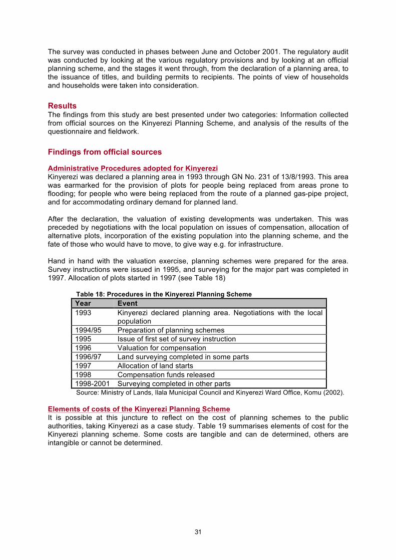
31
The survey was conducted in phases between June and October 2001. The regulatory audit was conducted by looking at the various regulatory provisions and by looking at an official planning scheme, and the stages it went through, from the declaration of a planning area, to the issuance of titles, and building permits to recipients. The points of view of households and households were taken into consideration.
Results The findings from this study are best presented under two categories: Information collected from official sources on the Kinyerezi Planning Scheme, and analysis of the results of the questionnaire and fieldwork.
Findings from official sources Administrative Procedures adopted for Kinyerezi Kinyerezi was declared a planning area in 1993 through GN No. 231 of 13/8/1993. This area was earmarked for the provision of plots for people being replaced from areas prone to flooding; for people who were being replaced from the route of a planned gas-pipe project, and for accommodating ordinary demand for planned land. After the declaration, the valuation of existing developments was undertaken. This was preceded by negotiations with the local population on issues of compensation, allocation of alternative plots, incorporation of the existing population into the planning scheme, and the fate of those who would have to move, to give way e.g. for infrastructure. Hand in hand with the valuation exercise, planning schemes were prepared for the area. Survey instructions were issued in 1995, and surveying for the major part was completed in 1997. Allocation of plots started in 1997 (see Table 18)
Table 18: Procedures in the Kinyerezi Planning Scheme Year Event 1993 Kinyerezi declared planning area. Negotiations with the local
population 1994/95 Preparation of planning schemes 1995 Issue of first set of survey instruction 1996 Valuation for compensation 1996/97 Land surveying completed in some parts 1997 Allocation of land starts 1998 Compensation funds released 1998-2001 Surveying completed in other parts Source: Ministry of Lands, Ilala Municipal Council and Kinyerezi Ward Office, Komu (2002).
Elements of costs of the Kinyerezi Planning Scheme It is possible at this juncture to reflect on the cost of planning schemes to the public authorities, taking Kinyerezi as a case study. Table 19 summarises elements of cost for the Kinyerezi planning scheme. Some costs are tangible and can de determined, others are intangible or cannot be determined.

32
Table 19: Elements of costs of the Kinyerezi Planning Scheme Element of Cost Tangible Costs Intangible/undetermined costs Declaration of a Planning Area
• Cost to government (distribution of information, etc)
• Indirect costs to landowners in terms of anxiety and discouraged development. and investment
• Waiting period: Area was declared a planning area in 1993, survey instructions issued in 1995, surveying completed in 1997. Suspense, non-investment, not knowing what to do
Identification of owners and negotiations
Costs borne by the government
Property Valuation Fees Cost borne by the government Property compensation Tshs 300,000,000
(USD 333,333), from the government
Popular dissatisfaction with compensation creates limbo and anxiety, disputes prevent development increasing project costs to the government.
Preparation and approval of Planning schemes
Costs borne by the government
Land surveying Tshs 620,000,000 (USD 688,888) from the government
Land allocation Recipients had to pay between Tshs 30,000-50,000 on allocation
• Administrative costs etc borne by government
• Costs to recipients of waiting, bureaucracy and commuting before allocation for recipients
Infrastructure No infrastructure was instituted
Certificate of Title Recipients pay some fees Building permit Recipients pay some fees
Planning standards adopted for Kinyerezi At least five planning schemes were prepared for Kinyerezi. The plan adopted for the neighbourhood centre (TP No. 1/838/597; area 208.33 ha) gives us an idea of the planning standards adopted in planning schemes in Tanzania. Plots for residential plots were extremely low density (1800 m2). The reason for this, according to officials, was to allow house construction as well as farming and animal husbandry, although these activities are not mentioned as permitted uses in the offers for a right of occupancy, which allows only residential uses. Experience, however, shows that once an area is declared a planning area and is planned, agriculture in the sense of wanting to use large parcels of land loses importance. Large plots are an almost unquestionable invitation for medium and high-income households to poach the area from low-income households. The roads had the following provisions: Neighbourhood collector roads, 30m Right of Way (RoW); secondary collector roads, 20m RoW; access roads, 10m RoW; and access paths and cul-de-sacs 10m and 5m RoW. The roads are obviously over provided for, given the

33
limited level of vehicular traffic at present or likely in the future. Cul-de-sacs, for example, are 10m wide. Access paths meant to provide pedestrian and bicycle accessibility are 5m wide. There is no justification for such wide provisions for access facilities. Details of the planning scheme provisions adopted are shown in Table 20. Table 20. Planning profile for Kinyerezi neighbourhood centre Land Use No of
Plots Plot size m2 Total area
(Ha) Percent of total area
Residential 624 1800 112.32 53.91 Neighbourhood centre • Pombe shop* 1 2500 0.25 • Light industries 8 1800 1.60 • Commercial 32 450 1.44 • Market 1 4200 0.42 • Community centre 1 2100 0.21 • Church 1 3900 0.39 • Mosque 1 3600 0.36 • Pharmacy 1 1800 0.18 • Nursery school 1 3780 0.38 • Public building 4 1800 0.82 Sub-total, neighbourhood centre 6.05 2.9 Cemetery 6 31000 3.11 1.49 Primary School 1 74000 7.40 3.55 Gas Pipeline reserve 99000 9.90 4.75 Circulation (Roads) 46.54 22.34 River valleys, tree/plants 9.82 4.72 Dispensary 1 15600 1.56 0.75 Secondary School 1 70400 7.04 3.37 Bible School 1 26300 2.63 1.26 Church 1 14100 1.41 0.67 Open space 5500 0.55 0.26 Total Neighbourhood 208.33 100
* Local liquor public house Source: Ministry of Lands (1996), Planning Proposals for Kinyerezi Resettlement Area, Dar es Salaam City. Regulations adopted for Kinyerezi In line with the usual practice, those who were offered land in Kinyerezi were given, documents with regulations covering what to develop on the land. These included specifications of allowed land uses, payment of land rent and other charges, submission of building plans, non-subdivision or assignment of the allocated land, keeping of beacons, and so on. Most of these are shown in the letter of offer for a right of occupancy. A typical case is that shown in Table 21. Table 21: Typical conditions and charges on getting an offer for a right of occupancy in the Kinyerezi Planning Scheme Date of offer May 2000 Plot 677 Block “B” Kinyerezi Term 33 years from 1st April 2000 Rent Tshs 9750/= payable annually in advance, revisable every ten years User Residential purposes only. Use Group “A” use classes (a) and (c) as
defined in the Town and Country Planning (Use Classes) Regulations,

34
1960 Building − To be in permanent materials
− Plans to be submitted to the Dar es Salaam City Council within six months of the commencement of the Right
− Building to be completed within 36 months of the commencement of the right
− Building to begin within 6 months of the approval of the plans Fees
On accepting the Right, the following amount in Tanzania shillings was required to be paid within one month of the offer:
Fee for Certificate of Occupancy Registration Fee Survey Fee Fee for deed plan Stamp duty Land Rent Total
2000 1950
28275 6000
590 9752
48567
The occupier has to pay any further fees and charges as may be required
Beacons Occupier responsible for the protection of beacons Subdivision No subdivision or assigning without the consent of the Commissioner
for Lands Further information required
− Full name in block letters. Certificate were not be issued in names other than that of the offerree
− Full residential address including block number, street number − Whether Right is to be held as joint tenants or tenants in common
Lapse of offer Offer lapses if sums listed above are not paid within 30 days of the date of offer
Source: Land Records The amount of Tshs 48,567 shown in the table above must be paid in one lump sum on getting an allocation. When household income (Table 22) is taken into consideration, it can be concluded that the amount is more than one month’s income in over 60 percent of the households in Kinyerezi.
Findings from the fieldwork We now turn to the findings from the field survey based mainly on the prepared questionnaire and interviews starting with the issue of compensation for the whole area and going on to Kinyerezi planned area ending up with the Kinyerezi unplanned area. The question of compensation The compensation rates for existing property in Kinyerezi generated a lot of dissatisfaction. The WEO for Kinyerezi confirmed that he received more than 53 letters of complaints against the land acquisition and compensation exercise. Dissatisfaction with the figures of compensations constituted 90.6 percent of the complaints. The remaining 9.4 percent of the complaints concerned non-inclusion of some developments (e.g. crops) in the valued assets; non-payment of disturbance allowance or the way the whole exercise was carried out. The other major complaint was against the long waiting period before payment was effected. Many had to wait for a year or more before getting compensation. Other complaints hinged

35
around favouritism and non-allocation of alternative land1. Box 2 expresses the views of an affected resident. Box 2: Views of Mr JJ of Mnembwe Area, Kinyerezi
“I remember several officers came here to address the wananchi (the public) about the planning and surveying exercise and the new status of Kinyerezi. They included the then District Commissioner, Mr. Mkuchika, Land Officers and the Commissioner for Lands. A meeting was held at the Kinyerezi Primary School and we were told that Kinyerezi is now a planning area and that it was only crops that would be compensated after planning and surveying. When they came to survey, they did it in a hurry. The same was the case with assessment of compensation. On this side we have not been compensated because even the valuation was not done. We only hear that it has been done in some other areas and people have been paid compensation. This is a third year now and nothing has happened in this area of ours. People are continuing to build and the situation/extent of development is not the same as it was three years back (i.e. in 1998). If they will come again they have to start the whole exercise afresh! Otherwise we will resist because it is not our fault. You cannot stop somebody from carrying out any development for three years while you have not compensated him/her! We wonder why they did not issue plot numbers or offers of a right of occupancy or compensation. They did not even discuss the modes of valuing and/or paying compensation”. He concluded by saying resignedly: “what is obvious is that the Government is above everything, what it decides, is what takes place.” (Source: Fieldwork interview)
Problems related to land acquisition and compensation are a major bottleneck that make it difficult for low-income households to get onto the legal shelter ladder. Further insights into the problems of compensation and the allocation of alternative and can be gauged from the case of Mr GZ, (Box 3). Box 3: The Case of Mr GZ Mr GZ acquired a plot informally in Kinyerezi in 1991. When the area was surveyed in 1997/98 his plot was compulsorily acquired and he was ordered to move off the land. On the plot, he had a three-bedroom structure. His entitlement for compensation was assessed at Ths 600,000/= (USD 951). He was also promised two surveyed plots. It took over 6 months for the compensation to be paid. As the promised plots were not forthcoming, Mr GZ decided to buy a small plot in the unplanned part of Kinyerezi in 1999 for a sum of Tshs 120,000/= (USD 170) which he paid in four instalments. In May 2001, he was allocated one plot (900m2) in the surveyed part of Kinyerezi. He had in the meanwhile constructed a three-bedroom house in permanent materials as well as a temporary structure on the unplanned plot. He had therefore no funds to develop the surveyed plot that he was offered. He was planning to sell that plot and expected to realise between Tshs 700,000/= USD 778) and 1,000,000/= (USD 1,111), which sum he could use to acquire (more) land in the unplanned area and to develop it. (Source: Fieldwork survey)
There were cases where offers for a right of occupancy were rejected. The case of Mrs TY and her family of Mnembwe area of Kinyerezi illustrates this point (Box 4). Box 4: Offer of a right of occupancy over land rejected “This is our land that we inherited from our parents in 1964. We have lived here all this time till the area was surveyed in 1997 by the authorities. There was no prior information of their coming. We just saw them coming and doing their surveying. Even our Mjumbe (local leader) was not aware of what was going on. After they had completed the survey, they went away and there was no feedback till the year 2000 when they came back to allocate the plots. They had a list full of names of their friends and acquaintances. This created a major conflict because the list of offerees/recipients had very few names of the current local residents. We, as a family, were supposed to get five plots, one for each of the family members, but instead we were allocated only one. A few days later, they brought us an offer for the one plot, but we rejected it, because we wanted five. They left the offer at the Ward Executives Offices where it is still lying to-date. The issue is yet to be solved.” Source: Fieldwork interview with Mrs TY of Kinyerezi
1 Much of the complaint was championed by The Kinyerezi Complaints Committee, chaired by one A. Gonegwa.
36
It seems as can be gathered from Box 4 that officials decide rather arbitrarily as to the number of the plots that the existing landowners will get after the land has been surveyed, and this could be unfair to the landowners. Also non- or late allocation of alternative plots is a major cause of dissatisfaction among residents whose land was acquired (Box 5). Box 5: Living in anxiety after land has been surveyed Mrs AM is a widow whose land was acquired in 1996/97. She was paid compensation of around Tshs 2 million (USD 3170). She was also promised alternative land. As this was not forthcoming, she used her compensation money to but a plot in a nearby unplanned area in 1998. In the same year, however, the area in which she had bought the land was surveyed. Ever since that time, she has not heard from the authorities. She is now living in apprehension since she is technically a squatter. (Source: Fieldwork interviews).
The government spends a lot of money on paying compensation in implementing planning schemes. An approach based on land regularisation and legalising existing owners can minimise compensation as well as complaints. Kinyerezi Planned Area Socio-economic characteristics of the land owners in Kinyerezi Although in the past Kinyerezi was a rural area whose residents were mainly agriculturists, this is changing fast. According to our study, only 24 percent of the respondents depended exclusively on farming for their livelihood. Another 26 percent mixed farming with other activities such as employment in the public or private sectors. Some 6 percent were employed either in the public or in the private sector; but the largest proportion (44 percent) undertook some kind of business, or trade, or were artisans. This implies that urban types of activities are taking root in Kinyerezi. Over half (54 percent) of all the respondents hail from Dar es Salaam and the majority were born in Kinyerezi itself. The rest come from other parts of the country. The education level of the respondents is generally low, with 68 percent having only primary education. Some 18 percent claimed to have no education at all. The income levels of our respondents is as shown in Table 22. Generally speaking the income of the residents of Kinyerezi is low, with some 74 percent of households earning less that Tshs 55,000 (US$60) per month. The largest proportion of the respondents claimed to live at a subsistence level without income.
Table 22: Household monthly income, Kinyerezi planned area Income levels Percent households Subsistence/No income 34 Below Tshs 5,000 2 Tshs 5,000-30,000 16 Tshs 30,000-55,000 22 Tshs 55,000-80,000 14 Tshs 80,000-105,000 4 Over Tshs 105,000 6
Source: Fieldwork survey (1 US$=Tshs 900) The process of getting land Our study found that the two major ways of accessing land in the planned area of Kinyerezi were by way of allocation as a flood victim, or purchase before the area was planned (Table 23). One point to note from the Table is that it is becoming common practice that in order to get onto the legal ladder of planned plots, one needs to be in special circumstances, such as

37
living in flood-prone areas, or in areas that are the subject of other development schemes making it necessary to relocate some of the existing population. There is only a very remote chance that low-income households can get planned land through the normal channels of application and allocation. Also chances of allocation increase when land is acquired before the implementation of a planning scheme.
Table 23: Ways of accessing land in Kinyerezi planned area Way of accessing land Percent
respondents Allocation as a flood victim 32 Bought before land was planned 24 Inherited 20 Got land during Villagisation Programme 8 Bush clearing 6 Relocation from Songas Project 4 Bought from an offeree of Right of Occupancy
4
Allocated as a normal applicant 4 Source: Fieldwork survey
Time lapse between completion of surveying and issuing of titles Land began to be allocated in 1997. The time lapse between the completion of the surveying and the issuance of offers was as shown in Table 24.
Table 24: Time lapse between the completion of the survey and the issuance of letters of offer Time Lapse Percent respondents 1-6 months 52 7-12 months 20 Over 12 months 12 No offers 16
Source: Fieldwork survey From Table 24, the majority of the landowners were able to get offers within six months to one year. Pressure to resettle people earmarked to be replaced during the implementation of the gas to electricity project (Songas), and those being moved from flood-prone areas, helped speed up matters somewhat. However, some 12 percent had to wait for between 1 and 3 years, while 16 percent had no offers at all at the time of the fieldwork. This is three to four years after the surveying was completed. The reasons for this include conflicts such as double allocation or dispute over compensation, lack of feedback from the authorities and unauthorised transfers. In some cases, however, offers for a Right of Occupancy, were rejected on grounds of unfairness (see Box 4). Lack of offers creates anxiety among the landowners, adversely affecting their enthusiasm to develop the land. Opinion on plot sizes owned Table 25 indicates that opinions held on the size of the plot vary; 36 percent consider the plots to be too small, 54 percent think the size is just about right, and 10 percent consider the plots to be too big. The fact that the majority of the respondents consider the plot sizes to be either just about right, or too big can be interpreted as an indication that the plots are actually too big. This is because it is reasonable to expect land seekers to want to have large plots and therefore consider what they have as being too small.

38
Table 25: Opinions on plot sizes owned Plot sizes (m2) Opinion on the size (percent
respondents) Too
small Just about
right Too big
400-800 (high density) 22 14 6 801-1600 (medium density) 10 14 - 1601-4000 (Low density) 2 26 4 Overall percent households 36 54 10
Some 36 percent of the respondents had more than one piece of land within Kinyerezi (16 percent), and outside Kinyerezi (22 percent). The majority, however, (62 percent), had no other land. These are mainly those who were resettled from flood-prone areas (Table 26). Recipients who have land outside Kinyerezi are mainly those native to Kinyerezi, and have land in unplanned areas. This encourages them to sell the surveyed plots and move to these alternative plots. Those who have other land within Kinyerezi include those who were allocated more than one plot, after their land had been surveyed.
Table 26: Ownership of other pieces of land Owning another piece of land Percent households No other piece of land owned 62 Have other land outside Kinyerezi 22 Have other land within Kinyerezi 16
Source: Field survey Getting the Certificate of Title The situation with regard to the issuance of titles is bleak. Despite the government promises, only 4 percent of the households have title. The other 96 percent have no title some 4 years after the planning and surveying of the area (Table 27). Among those with title is a prominent businessman who did a close follow up with the Ministry and got the title within one year.
Table 27: Reasons for not having title Reasons Percent respondents Waiting for authorities to deliver the titles
60.5
No money to pay for the process 10.4 Currently making a follow up 6.5 Wary of the bureaucracy 4.5 No money and wary of bureaucracy 2.1 No offers 16.0
Most of the respondents had no idea what should be done to get the title. They were promised delivery by the government although this seems not to be fulfilled. For some, the process is expensive. Legally, a title is supposed to be issued within a month of the offeree/recipient accepting the offer for a right of occupancy. In practice, it takes several months or years before a title is issued. Land rent The owner of a right of occupancy has to pay land rent annually to the government. This is one element of the cost of ownership. The annual land rent rates for Kinyerezi are: 10 shillings per m2 for residential plots, 15 shillings per m2 for commercial plots and 30 shillings per m2 for commercial residential plots. This means the larger the plot, the higher the land rent. The annual land rent in high-density areas of Kinyerezi ranged from Tshs 3,000/= to

39
Tshs 26,000/=. It ranged from Tshs 5,000/= to Tshs 13,000/= for medium density areas, and Tshs 7,000/= to Tshs 40,000/= for low-density areas. The opinion of the respondents on the amount of land rent they are paying is shown in Table 28. Table 28: Opinion on Land Rent Land size m2 Opinion on land rent (percent respondents) Too high Right Too low Not paid yet Not stated Not known 400-800 (High density)
20 12 - 6 - 4
801-1600 (medium density)
12 6 - 2 2 2
1601-4000 (low density)
16 8 - 8 - 2
Overall percent 48 26 - 16 2 8 From Table 28, it will be seen that none of the landowners said that the land rent was low. The largest proportion said the land rent was too high. Large plots go with high rents, which low-income households consider to be too high. This may lead to low-income households selling their plots, for fear of failing to meet the requirement of paying annual land rent. Land development after allocation Land is supposed to be developed after allocation and the regulatory framework gives a procedure to follow and a time limit in which land must be developed. A survey of the Kinyerezi area revealed that much of the land allocated since 1997 remains undeveloped. This study was unable to get the absentee landowners and ask them why they had failed to develop their plots. However, the phenomenon of land remaining undeveloped for many years after allocation is a feature of many planned areas in Tanzania and has been documented (see for example, Kironde 1997). The main reason is the lack of development finance. Many households regard the process of seeking land as very distinct from that of developing it. Once land has been secured, a different process of putting together finances to develop it starts and this takes many years, since finances are obtained in small sums relative to the requirements for full plot development. Thus, the stipulations in the regulatory framework that the landowners must submit building plans to the authorities within six months of land allocation, must have the building completed within three years of land allocation is rarely adhered to. Construction may take ten or more years. Public authorities are usually not in a hurry to enforce development conditions. Revocation will only be considered after several years have elapsed and the landowner does not show any signs of wanting to develop the plot. Before revocation is effected, several notices of intention to revoke the offer will be issued. If the landowner can show some activity on the plot, then usually revocation will not be contemplated. Our respondents had developed their plots and were in occupation of their houses, but the houses were incomplete in many respects. However, before developing their land they needed a building permit from the local authorities. The study established that 98 percent of the surveyed landowners in the planned area of Kinyerezi did not have a building permit and only 2 percent were processing getting one. The reasons for this situation are shown in Table 29.

40
Table 29: Reasons for not having a building permit Reasons percent respondents No idea that a building permit is required 55.1 Bureaucracy and lack of money to process 24.4 Building existed before land was planned 16.3 Making a follow up 2.0 Conflict over land 2.0
Source: Field survey The assertion by landowners that they had no idea that a building permit was required is an indicator that many regulations are not known to many of the landowners. Technically, all those who have constructed without building permits are in breach of the regulatory framework. However, it is very rare that action is taken against such flouting of development conditions. Selling allocated land Some of those who get a land allocation opt to dispose of it, usually by way of selling. Selling land before meeting development conditions is illegal. Such land is supposed to be surrendered to the Commissioner for Lands for reallocation. The fieldwork study in Kinyerezi indicated that some of those who are allocated land do sell it. Since our sample relied on existing land owners, it was not easy to get a clear picture of land selling from them although 15 percent of our respondents had actually sold part of their land. Some had done so before the area was planned. Some of the reasons given justifying the sale of land are: to solve double allocation problems, to raise money to address a family issue (such as paying school fees, sorting out issues of inheritance etc), and inability to develop the plot. However, our respondents were asked to indicate whether any of their neighbours had sold land. Some 66 percent of the respondents said they had witnessed their neighbours selling land. The reasons for selling land were given as shown in Table 30. Thus, much as the government prohibits the transfer of land without consent, such transfer is taking place.
Table 30: Reasons for selling land, Kinyerezi planned area Reasons for selling land percent respondents Inability to pay land rent 31.5 Inability to develop the plots 26.3 Having surplus plots 21.0 To supplement household income 10.6 Inability to cope with new life style (urban)
10.6
Source: Fieldwork survey The fact that landowners can sell land because of their inability to pay land rent is significant since the larger the plots, the higher the land rent. If people sell land because they cannot develop it, then the mere access to land may not be the only solution to the problems faced by low-income households in terms of getting legal housing. There is a need to look into the possibility of enabling the landowners to develop their land. Inability to cope with a new lifestyle is an indicator that some households are apprehensive that the area will be developed to standards which they cannot cope with. This is usually the case where plots are large, as is the case with Kinyerezi. The process of buying and selling land in Kinyerezi Individual land seekers may themselves look for those with land to sell. Increasingly, there are “barefoot” land brokers facilitating this process. According to one land broker, Mr NSM,

41
land selling in Kinyerezi became prominent after flood victims started to be resettled in the area in 1999. A sale agreement is entered into, on a special form obtained from the village government. It shows the buyer, seller, location of the plot, witnesses, price and the revenue for the village government. Some of the buyers and sellers bypass this village government system in order to avoid paying the 10 percent village government fee. An important point to note is that, while village governments facilitate the sale of land, the central government (through the Ministry of Lands) is usually against such sales and blocks or otherwise discourages land transfers from seller to buyer. The price of the land is negotiable, but prices of Tshs 500,000 (USD 556), 800,000 (USD889) and 1,000,000 (USD1,111) were typical for high, medium and low-density plots respectively. These prices are high for low-income households. This may explain why over 70 percent of the buyers are from the city. All in all, however, the system looks simple enough. Problems arise when all this has been done and transfers must be effected with the Ministry of Lands. The issue of whether the land is developed or not becomes a major stumbling block. Transfer will not be allowed if land is not developed to the satisfaction of land officials. Thus, a plot of land bought in the process described above remains officially in the name of the seller, although practically it may be in the hands of the buyer. This is a situation that is undesirable. Facilitating the transfer of land from one person to the other is bound to lower costs of access to legal shelter. Unplanned Kinyerezi The unplanned part of Kinyerezi is abutting the planned part and has pockets that are planned. Interaction between the planned part and the unplanned part is intense. Some 44 percent of all of our respondents in the unplanned part were born in Dar es Salaam. Livelihood activities About 50 percent of the interviewed residents depend on subsistence agriculture and other forms of manual work for their livelihood. The remaining 50 percent are employed in the public or private sectors, or are self-employed. Self-employment includes shop keeping, running a stall for selling l foodstuff, tailoring, plumbing, plaiting and selling mats, selling of second-hand clothes, welding, and masonry. The monthly monetary income from non-subsistence farming activities range from Tshs10,000/= (US$11) to Tshs100,000/= (US$111) with an average of Tshs 42,000/= (US$47). Land sizes owned The land sizes owned in the unplanned area are large and range from below 2023m2 (0.5 acres) to 8,094m2 (2.0 acres) (Table 31). This reflects the fact that the area is still very much rural (see Figure 2). Nevertheless, this is changing. Those who bought land in the 1980s were able to get large pieces of land compared to those who bought land in the 1990s (Table 32).
Table 31: Land sizes owned in the unplanned area Land size Percentage respondents Below 2023m2 (0.5 acres) 51.0 2023m2-4047m2 (0.5 acres-1.0 acres) 32.7 4047m2-8094m2 (1.0-2.0 acres) 16.3
Source: Fieldwork survey

42
Table 32: Decreasing sizes of land purchased Period of land purchase Percentage households Average size of land purchased Before 1985 6.7 8094m2 (2.0 acres) 1986-1990 10.0 2023m2 (0.5 acres) 1991-1995 33.3 2023m2 (0.5 acres) 1996-2001 50.0 1295m2 (0.37 acres)
Source: Fieldwork survey Despite their having what could be considered to be large pieces of land, 51 percent of the respondents thought their land was too small (60 percent of these had less than 0.5 acres/0.2 hectares) and 49 percent thought the size was just about right. None thought their land was too big. Nevertheless, much of the land owned, was undeveloped apart from the one residential house on most plots.
Figure 3: Housing in unplanned Kinyerezi showing good quality buildings.
Source: Evelyn Tehrani
Plot sizes in unplanned areas In order to get an idea as to the sizes of plots in informal settlements generally in Dar es Salaam, a study of sections of a number of unplanned areas based on the 1992 aerial photographs was carried out. This was done by identifying a fairly well developed part, calculating the area based on grid lines and then counting the number of houses. It was found that the plot sizes per house ranged from 222m2 in high-density (usually older) areas to 1,500m2 in newer areas (Table 33). Although these sizes may be considered to be generous, they are much smaller than what is provided in planning schemes like that of Kinyerezi. In this planned area, the smallest plot is around 800m2. Table 33: Land sizes per house in select informal settlements in Dar es Salaam
Settlement Location/Density Area (m2) No of houses Area per house (m2)
Kigamboni ward Near city centre/medium 437,500 663 660 Segerea ward Outer city/low 250,000 165 1515 Ubungo ward Outer city/medium 125,000 218 573 Ukonga ward Outer city/medium 250,000 183 1366 Mbagala Outer city/high 62,500 197 317 Mikocheni Outer city/high 62,500 282 222 Tandale Inner city/high 62,500 279 224 Manzese Inner city/high 62,500 279 224

43
Source: Calculated from aerial photographs of the Ministry of Lands, 1992 Access to land Respondents were asked how they got access to land. The major mode of access was purchase (60 percent), followed by inheritance (32 percent) (Table 34). This is different from the planned area where the major form of access is allocation.
Table 34: Modes of accessing land, Kinyerezi unplanned area Mode of access Percentage Bought from traditional land owner 52 Inherited 32 Bought from somebody who also bought
8
Allocated during Villagization programme*
6
Given by a relative 2 * Late 1970s, early 1980s Source: Fieldwork survey
33 percent of the buyers bought their land between 1991-1995 and 50 percent bought theirs between 1996-2001. Some of the land buyers sold their surveyed plots and combined the money with the amount they got as compensation to acquire and develop land in the unplanned area. Commenting on the land prices, 53 percent of the buyers thought the price was just about right, 33 percent thought the price was too high, and 13 percent thought the price was on the low side. The process of buying and selling appears to be efficient since a deal can be clinched within a week. Lawyers are usually not involved (Table 35). Payment in instalments is acceptable, and in our study, 43 percent of the buyers paid in two or more instalments.
Table 35: Duration of negotiations to purchase land in unplanned Kinyerezi Duration of negotiations Percentage respondents One week 60.0 Two weeks 3.3 Three weeks 3.3 Four weeks 13.3 Over four weeks 20.0 Two months 6.7 Twelve months (one year) 6.7 Three months 3.3 Seven months 3.3
Source: Fieldwork survey The most common witness of the sale is the ten-cell leader or mjumbe (Table 36). Both of these are local political leaders. Table 36: Witnesses to the sales of land Witnesses to the sales Percentage respondents Seller, buyer and their witnesses with local leader 70.0 Seller, buyer and their witnesses without local leader 16.7 No witnesses 6.7 Seller, buyer and their witnesses, ten cell leaders and ward office
3.3

44
Seller, buyer and their witnesses and a middleman 3.3 Witnesses may be paid some fees for their services at the discretion of the buyer or the seller, but there are no fixed rates. Local leaders are paid anything between Tshs2,000/= and 10,000/= (for acting as witnesses. It was, however, found that most buyers and sellers avoid the ward offices. Most land buyers (90 percent in our study) have the sale agreement as evidence of their ownership. The balance of 10 percent did not have any evidence. The agreement is signed at the time of the sale and refers to the consent and willingness of the seller to dispose of his/her land, the location and size of the land, the developments on the land, the names of the buyer, seller and witnesses, the date of sale, the price paid and any conditions attached to the sale. Signatures of the buyer, seller and witnesses as well as the local leaders are affixed. Legalising land acquired in unplanned areas While it is easy to acquire land in an unplanned area, it is difficult to legalise it. Planning consent must first be obtained and land must subsequently be surveyed to the approval of the Ministry of Lands. Thus, only 12 percent of those who acquired their land in the unplanned areas had surveyed their land, while 2 percent are in the process of surveying. However, 86 percent have not surveyed their land. Those who surveyed their land used private surveyors, or engaged the public sector (Ministry of Lands, The City Council, or the Municipal Council). Private surveyors charged 250,000/= (US$278) per survey. Use of surveying services from the public sector requires those in need of these services to provide transport for the surveyors, their technicians and their equipment. Where land had been surveyed, it was not easy to get an offer for a right of occupancy. Waiting periods of one to over three years were recorded. Getting a title is even more difficult. In our study, there was not a single respondent in Kinyerezi unplanned area who had a certificated of title over their land. Clearly, this is an area where the regulatory framework can be revised to allow those who access land in the informal sector to attain legality. Nevertheless, our study found that there was apprehension about the outcome of surveying one’s land. While a few cited the advantages of having land surveyed, many were against getting their land surveyed, citing problems such as having to pay land rent annually, the possibility of losing one’s land, getting little compensation, or getting relocated to a place that is not preferred, or that lacks developments that the current land has (such as mature trees which may take years to mature, if one has to plant afresh). Selling of land Some 36 percent of our respondents had sold part of their land. While most of he landowners were local to the area and had inherited land from their forefathers, the majority of the buyers were people from outside Kinyerezi. In 77.8 percent of the cases, these were from the city of Dar es Salaam. The reasons for the sale of land include the realisation that Kinyerezi was becoming urban and therefore agricultural activities would lose importance, in which case, one did not need large pieces of land. Others sold land to solve family problems or to raise money to pay for expenses such as school fees, house improvement, meeting medical bills, raising capital for business and so on. Building permits Most of our respondents in this unplanned part (i.e. 82 percent) said that they did not know whether their area was governed by any land use regulations. Most (98 percent) said they did not have a building permit, advancing many reasons for this situation. Many said they knew nothing about the existence of building permits. Others said theirs was an unplanned

45
area where the requirements for a building permit did not apply. This, of course is not the case. All developments in an area declared to be a planning area need the permit of the planning authorities.
Figure 4: Phased Construction due to fluctuating incomes, Kinyerezi unplanned area
Source: Evelyn Tehrani
Figure 5: Locally produced bricks ready for construction,
Kinyerezi unplanned area
Source: Evelyn Tehrani
Evaluation of the regulatory framework as applied to Kinyerezi From the way the Kinyerezi planning scheme was implemented, it is possible to make an evaluation of the regulatory framework in Tanzania. The administrative procedures applied to Kinyerezi are the standard ones based on land acquisition, planning, surveying and allocation. We have seen how this approach made it lengthy to have legal land made available. Even when this land was made available, getting

46
it to the recipients and providing them with the necessary papers took a long time to be implemented.
In terms of standards, the sizes of residential plots provided for in Kinyerezi were very generous. Land for circulation was the second biggest consumer of land (Table 20). It can be argued that if smaller plot sizes, such as the 288m2 that were used in the sites and services schemes of the 1970s had been adopted, then some 3,900 plots would have been obtained from the neighbourhood centre alone2. Instead, only 624 plots were demarcated. The second largest user of land is land for circulation (roads - 22.34 percent) consuming some 465,400m2 of land in the central area. This is partly because roads are over-provided for. A reduction of the standard for the roads by 50 percent would release 233,700m2 of land. If this is put to plots 288m2 in area then another 808 plots could be added to the supply. If such standards were to be adopted throughout Kinyerezi then some 15,000 residential plots would have been realised instead of the 3,600 odd plots that were demarcated. This would no doubt make a dent into the demand for planned plots. Streamlining of the administrative procedures would also be necessary to smoothen the making of these plots available to land seekers. Thus, one area where standards could be revised is to adopt smaller plots and to increase the proportion of land going to residential uses from such uses as roads. Unfortunately, recent planning practice seems to be driving in the opposite direction of wanting bigger and bigger plots. Not only do these constrain supply, they increase the unit cost of land surveying and land servicing, and also lead to urban sprawl. Also, large plots have high ownership costs, one of which is the annual land rent. Findings presented earlier from the fieldwork findings, reveal that a number of low income households who were allocated plots in Kinyerezi decided to sell them because they felt they could not afford the annual land rent. Plot ratios also mean that only a maximum of 40 percent of the land on plots classified as high density can be legally built upon. This has remained so even as the minimum plot size has been raised from 288m2 to 400m2 as in the case of Kinyerezi. Besides, the plot ratio becomes smaller with land that is large and classified as medium or low density. Setbacks also consume a lot of land unnecessarily. Infrastructure of any kind was not part of the Kinyerezi planning scheme. Regulations as applied to Kinyerezi define allowed land-use classes. These are reflected in the offer for a right of occupancy. It was established that land use class regulations were not a major problem in Kinyerezi. A number of economic activities were undertaken on some of the respondents’ plots. Indeed, one argument in favour of large land lots in Kinyerezi is to allow agriculture. Urban farming is therefore allowed and regulated under the Urban Farming Regulations Order of 1993.
Comparing the planned to unplanned Kinyerezi The regulatory framework can be further evaluated by comparing how it operates in planned Kinyerezi to the situation in the unplanned part. The administrative procedures as currently practised, make the preparation of planning schemes and thus the availability of planned land a very expensive undertaking. Since resources are limited, both central and local governments have been unable to muster resources to undertake sustained planned land delivery schemes. The Kinyerezi scheme cost at least Tshs 1 billion in compensation and land surveying costs alone, leaving aside
2 It should be remembered that plot sizes of 288m2 are considered generous in many countries.

47
the costs of preparing the planning scheme and other related costs. Even when land was finally available, it took up to three years before the beneficiaries got a Letter of Allocation (Offer). In the short term, access to land in unplanned areas does not cost the government much although future cost of upgrading may be high. Access to land by individual land seekers in an unplanned area can be realised in as a short a time, as one week, although as has been pointed out above, it is very difficult to convert land acquired informally into legality, the main reason being that such land must fit into an official planning scheme and must be surveyed, and the survey approved by the Ministry of Lands. The plot sizes in unplanned Kinyerezi are large, but this is because the area is still sparsely populated. In any case, evidence produced in this report shows that land sizes in the unplanned part have been decreasing with the passage of years. The size of roads in the unplanned area is just wide enough to allow the passage of one vehicle (i.e. around 4 metres wide). In both areas, there is no infrastructure instituted. The land for the roads has been set aside for the planned part but the roads are not made. In both the planned and unplanned parts, roads and paths are just earth, with many troughs that fill with water during the rainy season. In the planned part, these do not necessarily follow the plan, although the population know exactly where the roads are planned to pass. In both the planned and unplanned part piped water networks are missing. People depend on natural wells for their supply (Njechele, 2002). Regulations are articulated in the offers for a right of occupancy given to the recipients in the planned part. But these do not seem to be unduly onerous and people are able to use their pieces of land for a variety of activities. It appears that few people know about the existence of regulations as evidenced by the majority not knowing that they are supposed to apply for a building permit. We can therefore conclude that administrative procedures impose the highest costs and the highest constraints, particularly by their restricting the supply of planned land, and making access to land a protracted process. Most people get land from the informal sector. The failure of the regulatory framework to convert land acquired informally into legality means that many poor landowners hold land illegally or under vague conditions.

48
RECOMMENDATIONS FOR ACTION
Long term The major problem in the case of Tanzania is the limited supply of planned land. The long-term goal therefore must be to increase supply by doing away with aspects of the regulatory framework that restrict supply, and also bringing into play aspects that can increase it. Administrative procedures Administrative procedures have been identified to be the major obstacle towards increasing supply. There is a need to conduct studies to identify ways and means of decentralising much of the land administration powers from the central government, to the local governments, and lower down the hierarchy. Thus for example, the declaration of an area to be a planning area need not be done at Ministerial level. Planning schemes can be approved at local government level. Surveying instructions can be issued at local government level and surveying approved at that level as well. The question of compulsory land acquisition and compensation, need not be dealt with at national level, where this involves local land planning schemes. Applications for land and land allocations could be handled at lower levels of local government such as wards. Likewise, the question of issuing titles at local authority level could be looked into, although there is the argument that this is too sensitive to be decentralised. Capacity building is necessary at sub-Ministerial levels to prepare a framework that can handle these responsibilities. At the same time, regulations need to be formulated that will define the role of the various authorities in this decentralised situation. The Ministry of Lands could issue policy directives and act as a watchdog to ensure that lower authorities do not abuse their position through acts of omission or commission and have a framework within which to fulfil their duties. One aspect of increasing supply is to widen the range of actors that can play a positive role in making land available. Thus, landowners could be enabled to seek planning permission (which should be granted at the local authority level), and plan their land with the advice of planning authorities. Once this is accomplished, landowners should be free to bring their land into the market and transfer it to whoever requires it at terms, which the two parties can agree. It is well known that land is bought and sold mainly in the unplanned areas, but this also happens in the planned areas. Generally speaking, the government is especially unhappy with the situation where people sell bare land and there are many impediments in transferring land ownership or converting land, which is acquired from the informal sector to legality. In the long run, the government should seek to enable the working of the formal land market, as this is likely to increase the supply of land and therefore lower its cost, thus increasing affordability. The government is also advised to encourage the formation of land buying companies, which should have a specific aim of assembling, planning, and servicing land, and bringing this land to the market. This can help increase choice and supply. Again, a regulatory framework enabling the working of the land market is required. Where people have already settled on the land and want to convert their settlements and landholdings into legality, the regulatory framework should facilitate them to do so. Although the majority of landowners in Tanzanian urban areas acquire land from the informal sector, and cannot therefore claim legality, the regulatory framework is not geared to assist these landowners. There is therefore a need to popularise such approaches to land management as regularisation, land readjustment, or land sharing so as to reach as many of the households as possible.

49
A major impediment to the supply of land is the approach that seeks to clear the land of existing land occupiers, plan and survey the land, and then allocate it. The problem here is the high cost and unpopularity of compensation, and the long procedures that this entails. An approach that does not seek to replace existing land occupiers, and that can allow them to dispose of their land as they find it fit, will not only reduce the compensation bill, but will speed up the availability of, and transactions in, land. A legal set-up to enable this system exists, but needs to be operationalised and streamlined. Standards As far as standards are concerned, the adoption of smaller plots and smaller areas of land for roads and utilities will increase the supply and lower the overall unit cost of servicing land. This includes the costs of land planning, surveying and land servicing. Although recent trends have been to increase the size of land plots, there is in the long run a need to have a policy that is geared to the more intensive use of land. Smaller plots will give more choice to poor households and, by increasing supply, will lower the price of land where it is sold, thus making it affordable to low income households. It will also reduce the cost of providing utilities, and the existing tendency of urban sprawl to encroach upon agricultural land, and increase distances to places of work. The cost of ownership, such as land rent and property tax, are high for larger plots thus making them unaffordable to low income households. The evidence adduced from the case study point to some households selling their land because of the fear of inability to afford paying the annual land rent. Others sell because they feel that they would not afford the high “neighbourhood standards” of land development that usually develop when plots are too big and get therefore poached by high income households. The high cost of land surveying has been alluded to. The standards that insist on individual plot demarcation or ‘monumentation’ need to be revisited in the long run, and be replaced with those that are cheaper and easy to execute at local level. Where an area is already settled upon and people want to convert themselves into legal residents, there is no need to insist on planning standards that are applicable to virgin areas. Standards and procedures that are applicable to such areas need to be developed. The standards prescribed for building permits are too high and the level of approval can be at a local level. After all, what we see on the ground, particularly in informal areas, is that people develop land as and when they decide to do so, although the local leadership and community can enforce some conditions on how the new building should be put up. Regulations Regulations seem to present the least constraint in allowing access to legal land. Zoning involving the separation of uses is adopted in preparing planning schemes. Thus, residential areas are usually separated from other uses, and the rights of occupancy specify the allowed uses. Nevertheless, there are other processes that allow economic uses on residential plots. In the long-term, there is a need to revise zoning regulations and allow more mixed uses in planned schemes, instead of relying on other processes. The offers for a right of occupancy, and the certificates themselves carry prohibitive provisions restricting uses on planned land, preventing subdivision and subletting and restricting the number of buildings on the site. A review of development conditions outlined in the Right of Occupancy may therefore need to be carried out.
50
The mere allocation of land to low-income households may not, on its own, ensure that these households consolidate their access to legal shelter. In Kinyerezi it was shown that a good number of those who were given official plots sold them and moved elsewhere usually in unplanned areas. Also, much of the allocated land remains undeveloped, presumably because recipients have no resources to develop their land. Therefore, assistance with house development finance may be a necessity. At the same time, the encouragement of livelihood strategies on the site or in the neighbourhood (e.g. the allowing mixed land uses, construction in cheap materials and subdivision of allocated land) may be necessary to stabilise low-income households.
Short term In the short term, it is recommended that the ongoing proposals to revise the Town and Country Planning Ordinance of 1956 should be supported, and inputs submitted that can lead to the formulation of a regulatory framework to remove the constraints pointed out above. Although recently enacted, the Land Act 1999 has been criticised for, inter alia, not recognising the value of bare land, making it difficult to transfer rights of occupancy, centralising powers of land administration in the Ministry, making it difficult for lenders to use land as collateral. Amendments are being mooted. It is therefore important to use this opportunity to amend provisions that constrain land availability or access to credit by low-income households. The government is also currently deliberating a National Housing Programme. This is an opportunity to convince the custodians of the regulatory framework to address issues that constrain the access to legal land by those who need it. Devolving more powers to local governments and encouraging them to address land matters can be part and parcel of this National Housing Programme as well as the ongoing Local Government Reform Programme. Planning schemes that are currently being prepared, or are being contemplated, could adopt different standards. For example, the tendency to go for larger plots could be reversed, at least on a trial basis, so that at least the larger proportion of plots in any planned scheme be of smaller plot sizes of 200m2 each in high density areas, so as to maximise the number of these plots in the few planning schemes available. The same could be said for roads, whose sizes could be revised downwards. It is proposed that neighbourhood collector roads be reduced to 15m RoW; secondary collector roads to 10m RoW; access roads to 5m RoW; and access paths and cul-de-sacs, to 3m RoW. Also, the encouragement of land occupiers to prepare planning schemes for their areas for approval by the Ministry may transform many illegal land occupiers into legal residents.

51
ADDRESSING CONSTRAINTS TO CHANGE The Phase 2 Report was completed in March 2003 and it was expected that the recommended changes would be agreed upon and introduced. However, this was not the case and it is instructive to ponder as to why change has been difficult to realise.
Reactions from the gatekeepers The agencies that are responsible for formulating, implementing and changing these aspects of the regulatory framework are mainly the Ministry of Lands and Human Settlements Development, the President’s Office, Regional Administration and Local Government, and urban local authorities. Professional bodies can also play a critical role in safeguarding, or campaigning for the changing of the existing regulatory framework. A National Human Settlements Development Policy was approved in 2000 (Tanzania, 2000). It seeks to give more powers to local authorities to manage land for settlements, to support land regularisation schemes, and to enhance the role of CBOs and NGOs in the planning and administering of human settlements. Overall, however, there is no clear government policy on the role and activities of these latter organisations. The Town and Country Planning Ordinance is currently under review and aims at among other things, decentralising activities from the Ministry to Local authorities. The major bottleneck envisaged is a lack of capacity within these authorities. The situation is rather regressive with regard to standards, especially plot sizes and road space. Recent steps are moving towards increasing the size of plots and to over-provide for roads. Also, the situation is regressive with regard to planning schemes that are prepared by the people, communities, etc. These are being subjected to high standards and can therefore not get approved. With regard to land surveying standards, the general argument is that the surveying department is blamed for happenings that are not its fault. If, for example, the land acquisition process worked efficiently and surveyors are given land without third party interests, they could do a wonderful job in producing surveyed plots quickly, especially with modern equipment and technology. Standards of accuracy inherited from the colonial days are still defended, although voices arguing for the revision of these standards are beginning to be heard (see for example Silayo, 2002). Some decentralisation of authority to the district surveyors has been implemented. The land management and administration sector is insisting that all certificates of title bear the signature of the Commissioner for Lands. The Land Act 1999 centralises most powers of land administration in the Ministry of Lands. However, some decentralisation of title preparation and registration has been implemented. Authorised officers are being appointed within local authorities to deal with land matters on behalf of the Commissioner for Lands. But generally speaking, this sector is slow in acting, as evidenced by the low number of planned and allocated land. Changes proposed from the RF Project The Regulatory Framework (RF) Project was aware during its design that change is difficult to achieve. Therefore, it aimed at realising modest initial changes, which might be easier to achieve and would pave the way for further changes in the future. Two of these changes, which appeared most significant in constraining households’ access to land, were selected. These were:

52
− A reduction of the minimum official plot sizes and land set-aside for roads and road reserves. This was meant to increase the supply of legal plots in any given planned land use scheme.
− Decentralisation of powers of land management from Ministerial levels, to lower levels of
local authorities and neighbourhoods. This was meant to go hand-in-hand with encouraging landowners and communities to plan their land for approval by planning authorities, instead of the authorities always aiming at displacing existing land users as part of the implementation of planning schemes.
It was also intended to test these recommendations in a pilot project where the planning of land would be undertaken with the existing landowners. This would take place in an unplanned area not far from the area where the research was carried out for the RF audit. The proposed changes in the RF were supported within wider government policies including the National Human Settlements Development Policy of 2000, the Local Government Reform Programme, the Poverty Reduction Strategy, and the drive to achieve good governance. In order to set the scene for achieving these changes, a Steering Committee was formed. It was chaired by the Director of the Human Settlements Development Division in the Ministry of Lands, and was made up of officials from central government, local government, academia and the private sector. Arguments for change were presented to this committee and deliberated upon. Two stakeholder workshops were held. Lobbying was done at Ministerial and local government level, including an audience with the Permanent Secretary, Ministry of Lands. Articles were written for local newspapers depicting some of the disadvantages of continuing with the current standards, and the advantages of, for example, going for smaller plot sizes. It was also known that there were plans to review the Town and Country Planning Ordinance (TCPO) of 1956, and that this offered a chance to include some of the envisaged changes in the new legislation. There was general agreement among officials that change in the RF was necessary and, in part, that was why the TCPO 1956 was being reviewed. Nevertheless, there was opposition to the project’s proposed reduction of the standards for plot sizes. It was argued that this would lead to overcrowding which would amount to new planned slums. It was generally argued that there was no shortage of land and there was therefore no need to cram people in a limited space. It was also argued that there was pressure to increase plot sizes after the experience of the sites and services schemes of the mid-1970s where the minimum size was 288m2. Box 6: The space standards for residential areas in Tanzania The arguments for large plot sizes in Tanzania are on the following grounds: − There is no shortage of land and therefore no need to cram people in a limited space − Small plots would soon lead to overcrowding and to slums − It was necessary to accommodate on-site sanitation particularly pit latrines, and septic tanks − It was necessary accommodate agricultural activities, an important consideration for poor
households Countering the above arguments, the RF Project called for smaller plot sizes on the grounds that: − Most people in low income households live on smaller plots, many smaller that 100m2, which are
therefore considered illegal

53
− It was necessary to maximise the number of plots on a given piece of land, particularly where this is in inner-city or easily accessible areas, which would fit the needs and means of poor households
− The more the plots on a given unit of land the lower the unit cost of infrastructure − It was necessary to prevent urban sprawl with its immense economic and social costs The following contextual framework which generally supports the idea of large plot sizes should be born in mind: − Land is considered to have no value when bare or undeveloped − Planned land is usually allocated without substantive infrastructure − Beneficiaries of planned land do not usually pay the full cost of this land − Land is developed slowly and incrementally by individuals, without any official financing facilities.
There is therefore lack of a budget ceiling. This leads to the design and construction of large houses, particularly for high and middle income households
− Plot coverage regulations are not enforced. Houses that cover most of the plot’s area, creating an impression that the plots are small
− Construction is usually horizontal rather than vertical − Policy makers think in terms of their own needs ignoring all evidence of space requirements for
poor households. The voice of the poor in terms of land requirements and issues of affordability is not heard or accommodated
Despite efforts through workshops, lobbying, and the media our arguments for the lowering of plot sizes have so far proved unsuccessful. This is likely to remain the case, as long as the full cost of the various planned land use schemes is not reflected in the final cost of the individual plots. Nevertheless, a growing number of professionals and researchers are arguing for a reduction of plot sizes. Lupala (2002: 249) concludes that: “between 100 and 200 square metres plots would be appropriate for many kinds of residential forms, and within acceptable ranges, if aspects of infrastructure provision… are to be addressed”. In terms of decentralisation of land management powers, opponents argued that this was not supported by the existing legal framework as outlined for example in the Land Act 1999 where powers of land management were concentrated under the Commissioner for Lands. It was also feared that too much decentralisation could lead to corruption. However, the Annual Report on the State of Corruption in Tanzania 2002 (ESRF-FACEIT 2002) concludes that there is corruption at the Ministry of Lands. Areas prone to corruption are those dealing with the survey of land held under customary tenure, with Rights of Occupancy and the assessment of premium to be paid prior to the grant of a Right of Occupancy. Other areas are those dealing with consent/approval of a disposition relating to a Right of Occupancy, changes of tenure, the renewal of a Right of Occupancy, revocation of a Right of Occupancy, mortgage registration, as well as applications for rectification of the land register. A total of 23 officers suspected of corruption or malpractice were indicted or dismissed and seven others were taken to court (ESRF-FACEIT, 2002: 31-32). The corruption argument at local level is possibly exaggerated. Furthermore, it was argued that there was no capacity for effective and efficient land management at lower levels. This argument is also contentious. Local officials feel that their major constraint is finance. Human capacity has greatly improved at local level with the transfer of key staff to local authorities as part of the ongoing Local Government Reform Programme. An opportunity to test the acceptability of the ideas for change presented itself when the government decided to implement a large planned land provision scheme in the city of Dar es Salaam in the first half of 2002 i.e. the 20,000 plots Project. Unfortunately, very few of the ideas proposed by the RF Project were taken on board. The project was administered at Ministerial level; it adopted the “acquisition-clearance-allocation” approach; land use

54
planning did not involve land occupiers, communities or the private sector, although the latter sector was marginally involved in providing services such as land surveying, and property valuation. Moreover, the size of land plots adopted was generally higher than in previous schemes, rather than lower as we had recommended. The high-density plots (i.e. small plots measuring 400-800m2) were a minority in the whole scheme. The result has been that compensation has consumed the budget for the whole project, which is suffering from cost overruns. The whole project, including land acquisition, planning and surveying and some basic infrastructure was budgeted to cost US$8,900,000. As of January 2004 compensation alone had cost US$12,500,000, indicating major cost overruns and the danger of non-sustainability. While it must be acknowledged that the plot delivery system in this project has been very fast, the plots are proving to be too expensive for the public in general and the poor in particular. Plot uptake has been much slower than had been anticipated and the poor have literally been edged out of this scheme. As of 30th June 2003, 21,833 plots had been surveyed, 16,747 allocated, but only 3,674 paid for (Tanzania, 2003). The government realises that the plots are too expensive for the poor but argues that it was important to deal with high-income households first, to prevent them from poaching areas earmarked for low-income households as was the case with the sites and service projects. The implication is that the government will undertake, later on, another scheme especially geared to low income households. The delay in realising changes can be attributed to a number of reasons: - Change comes only slowly, after many years of deliberation. Many officials are very slow
in accepting new ideas resulting in changes from the existing situation. There is the fear of the unknown. Considerable effort is required to put the new ideas in practice and there may not be the motivation to do so. There are no examples in Tanzania, of changes that have come about within a year or two of being proposed. There is always the need to repeat the issue in several fora to get a general consensus for change. Bureaucratic inertia was possibly the main constraint as opposed to defending current interests, or corruption. A lot of lobbying is also important and the researcher neither had the resources nor the time to mount the required lobbying.
- Perhaps it was too optimistic to envisage that the RF would stand-alone and draw the
necessary attention, given other ongoing programmes aimed at the poor. There are programmes related to access to finance, primary education, basic health, water and so on. The RF should be part of the larger policies and programmes such as the Poverty Reduction Strategy Policies adopted in many African countries. In other words, to have the desired effects, the RF Project should have come in as part of a key programme, policy review or formulation (such as the National Human Settlements Development Policy, or National Housing Programme). The formulation of the study and its anchorage should have involved key policy makers/implementers. Envisaged changes should have been identified in the early stages of the Project, discussed with key stakeholders, and research carried out to inform these stakeholders of the desirability or otherwise of the proposed changes.
- Changes must be championed. In Tanzania, there is no caucus pressuring for change in
the RF or campaigning for making legal land available to the poor. There are for example, pressure groups campaigning for women, children and youths’ rights, for awareness with respect to HIV/AIDS and so on. There is an NGO in Tanzania known as Hakiardhi, fighting for land rights, but its concentration is on villagers threatened by eviction, and on pastoralists. It has not been possible to get a caucus that agrees on what changes in the RF to propose, and is powerful enough to be able to see these changes through. In fact, an idea has been put up by the Ministry of Lands that the poor, who cannot afford to buy the planned plots put up by the Ministry in the ongoing 20,000
55
Plots Project in Dar es Salaam, cannot be expected to be able to subsequently develop these plots into houses. This, of course, is not true, since construction is undertaken slowly over many years. It is surprising that this stand was taken by the government and stated in public in Parliament in view of the observation in the National Human Settlements Development Policy that “Housing is financed from personal and family savings over a long period of time … “ (Tanzania, 2000:8).
- There are many reforms, projects and programmes going on in Tanzania at the moment.
In terms of urban development there are the programmes of Sustainable Cities, Community Infrastructure, Safer Cities, the Local Government Reform Programme, City Alliance, and many others. The RF would appear to be seen as lacking in significance compared to other reforms, projects or programmes and needs a proper slot within these. There must be pressure to get the RF on the reform bandwagon. External pressure e.g. from donors is effective in bringing about reforms. The existence of so many reforms, projects and programmes at the same time leaves little time for officials to consider changes like those proposed for the RF.
- Opposition to change came from an unexpected corner when landowners in a large
unplanned area resisted all exhortations to convince them to prepare a plan of their own with the assistance of experts, and present it to the authorities for approval. The landowners believed there was a secret agenda whereby in the end they would find themselves losing their land without compensation. Clearly, if change has to be accepted, the people must identify with it. With hindsight, it is possible that the research team was regarded with suspicion since it was composed of the researchers and officials from the municipal council, as well as with local people who were identified with previous government land use schemes in the area. This emerged in the public meetings that we held.
- Sometimes, other interests determine action priorities. It is now accepted that the
general elections earmarked for 2005 are, to some extent, currently determining the direction of government action. Land-related projects that may get government support are those that can yield quick results and that can be pointed to by the politicians as having fulfilled election promises. The 20,000-plots project is seen in this respect. The ruling Party had promised in its election manifesto to deal with the problem of lack of planned plots. This had to be implemented and results shown in the forthcoming election campaigns. Short cuts, like compulsory acquisition and compensation, and centralised planning, were therefore resorted to, as opposed to negotiations, which would take a long time, and outputs would be difficult to show.
- The status quo may be defended partly because of the interests of the “gatekeepers”,
and partly because it is well known. Change means going into the unknown. Should matters go wrong, blame could be traded. For example, there is reluctance in Tanzania to revise standards for land surveying, due to fears that this may result in chaos and numerous (boundary) disputes. Thus the existing “well-tested” system is defended though it is slow and expensive. Fortunately, voices for revising land surveying standards are beginning to be articulated (Silayo, 2000).
- The voice of the intended beneficiaries of the proposed changes was not brought to the
forefront in both designing the project, and in campaigning for change. In the RF Project, the local population was involved only as interviewees. Representatives were nevertheless invited to workshops but did not attend. The language used in the RF project was a major barrier as the local population speaks Swahili very well but very little English. There was also fear that to mobilise the poor to have an effective voice on land matters, could be interpreted as constituting a political movement.

56
Nevertheless, some of the proposed changes have been listened to and incorporated in the proposed Town and Country Planning Act.
Recommendations included in the proposed Town and Country Planning Act As pointed out above, the Town and Country Planning ordinance is currently under review. Those offered an opportunity for some proposals from the RF Project to be tabled for inclusion in the proposed Act. Some of these have been taken on board in one form or the other. Changes that have been accepted include: - Decentralisation of many land management powers from the Ministry of Lands - Acceptance of flexible planning standards developed and approved at local or regional
level. - Allowing landowners to prepare their own land use plans and to have these plans
approved by the planning authorities. It is proposed to give landowners powers to have their plans supersede those of planning authorities. If and when such changes are accepted, there will be the need to build the capacity of landowners in the preparation of land use schemes that can get the approval of the public authorities.
- A more active role for CBOs, and NGOs. These proposed changes have been accepted because they were generally supported by academics and researchers, some of whom were given the task of formulating and leading debate on the proposed new Act. There is also a general acceptance in government that decentralisation of various powers is necessary, and is actually going on with a varying degree of success in many sectors, although the land sector is, in this respect, possibly behind compared to other sectors. The inclusion of communities, and their organisations is also a generally accepted policy in much of the ongoing sector reforms. Inputs from the RF project, and the evidence collected and analysed from the research helped to guide and strengthen the case for the proposed changes. The case was presented during the plenary sessions and expanded in working groups. One-to-one discussions were held with key officials, and the consultants entrusted with proposing the new Act. It is nevertheless realised that putting reforms on paper is one thing, but realising these changes in practice is a different matter. The Land Act 1999 has very good provisions for public participation and protecting the rights of individual landowners or communities, but these are not implemented in practice as envisaged on paper. Nevertheless, if the proposed changes are eventually adopted in the new Town and Country Planning Act, this will be a big boost for the RF Project and for land use programmes aimed at reaching poor households.
Considerations for the future In order to realise change, the campaign for the review of the regulatory framework should be fitted into ongoing policies, programmes and projects that are conducive to change. Political factors must also be considered. There is a need to build up a caucus, or pressure group, to take up the cause of access to land for the poor. This access will have many facets, including the question of finance, technology, good governance as well as the regulatory framework. This caucus should be

57
made up of researchers, academicians, politicians, government officials, and poor households. It should be interested in, and willing to campaign for change. Professional bodies in the country can play an important role in bringing about change. Land-based professional bodies in Tanzania, such as the Town Planning Association of Tanzania, National Council for Professional Surveyors, Institution of Surveyors of Tanzania, Tanzania Institution of Valuers and Estate Agents, Architectural Association and so on have not been very active and have a lot of matters that they need to do to put their own houses in order. It is realised however, achieving changes in the regulatory framework requires professional bodies to be on board. Unfortunately, the RF Project did not actively involve Professional bodies, and, with hindsight, this is seen as a weakness. In campaigning for change, the advantages of the proposed changes must be shown to outweigh the disadvantages, if any, of maintaining the status quo. In Box 7, some advantages of revising the regulatory framework are put forward. Box 7: Why a revised regulatory framework is good for appropriate urban land management All indicators suggest that over 70 percent of the residents of Dar es Salaam live in unplanned areas. The majority of the landowners get it from the informal sector. This land has no legal certainty. In realisation of this, the National Land Policy of 1995, and the Land Act 1999 provided for the legalisation and regularisation of land obtained otherwise than from public authorities. Unfortunately, since the Land Act 1999 became operative in 2001, no action has been taken in this direction. There are advantages in revising the regulatory framework as it relates to access to land. Overall, if the proposals for a revised regulatory framework are adopted, many, particularly low income, households would be able to get legal land. This would bring them in the ambit of formal land use regulation, meaning that the public authorities can exert their powers over a wider range of households. Building permit fees, land rent, and property tax would be easy to collect. Besides, public authorities would be able to know what was going on in their areas in terms of land development and economic activities.
The voice of the intended beneficiaries of change, in this case poor households, must be brought to the forefront without causing excessive concern in political circles. Poor groups must be involved from the very beginning, so that they interact with officials and politicians and each one’s position is made clear. This will avoid the interpretation that that there may be a conspiracy. It may not be possible to avoid stepping on somebody’s toes, but this should be minimised. It is necessary to avoid suspicion from poor groups of the purpose of the proposed changes. One way of overcoming such fear is to win the confidence of the local population by, for example, identifying personalities who are influential in this area, discussing changes with them, presenting them with possible benefits and giving them examples of successful cases, etc. It is important also to involve local representatives such as Members of Parliament, local councillors and traditional leaders. A word of assurance from public authorities in support of the proposed course of action is also very reassuring.
Conclusions The regulatory framework is one of the major causes of the shortage of planned land in Tanzania. The administrative procedures set down take too long to make land available to those in need and as a result many have opted to get their land from the informal sector where the result is the rapid growth of unplanned settlements in all urban areas in Tanzania. Whenever they are challenged with regard to this situation, public authorities blame a lack of

58
resources to acquire, plan and survey land as a major cause of unplanned development. Rarely do they address the issue of the regulatory framework. Where the public authorities obtain land, it is planned to high standards involving large plots and generous land for roads. As such, the number of plots realised from such land is lower than would be the case if smaller plots were adopted. Thus, many of the poor cannot be reached, and those few who get an allocation are usually those in extreme circumstances, such as being relocated from flood-prone areas or from areas earmarked for other projects. Many of the poor could be reached if the regulatory framework made it easy for land already settled upon informally to be easily converted into formal land. This, however, is very difficult. However, implementing the regulatory framework has its own problems. Many of the Acts and regulations are old and not readily available. Thus, many officials operate by depending on precedent. That may be part of the reason why some of the provisions that may speed up the supply of land are not applied. For example, the Town and Country Planning Ordinance, requires public deliberation of planning schemes. It allows land occupiers to submit their own land use plans for consideration and approval by the authorities. It also has provisions for the regularisation of unplanned areas. All these are rarely resorted to in the execution of planning schemes in Tanzania. There are no debates, seminars, workshops or refresher courses on the regulatory framework. Although the standards, administrative procedures and regulations adhered to lead to a high cost of planned land, this cost is not debated or perhaps realised. There are usually no calculations of the unit cost of planned land in both the short and long term periods. The cost of providing planned land is not directly paid for by the recipients. In most cases, it is borne by the government from special funds set aside for the purpose. Land is usually allocated without infrastructure. This means the cost, for example of large plots, is not readily apparent in terms of land servicing. Nor is the cost of urban sprawl taken into consideration. The actual anchorage of the regulatory framework is sometimes a problem. While most powers are centralised in the Ministry of Lands, there are many cases where there are overlaps. In the case study, for example, implementation of the regulatory framework involved the Ministry of Lands, the City Authorities, and the Regional and District authorities. This not only caused delays, but it also resulted into the application of different standards to different areas. The rates used for compensation were higher in the areas under the gas project compared to those under the City Council of Dar es Salaam, leading to major discontent among the affected population. Decentralisation of powers of land management and administration and the mobilisation of land owners, communities and the private sector to plan, regularise and service land should be the focus of land management policy. In order to maximise the land available for households, in any one planning scheme, it is recommended that the sizes of land parcels for residential plots be reduced, as should be the areas for roads and other uses. The idea should be to greatly increase supply of planned land at lower cost, so that many of the poor can be enabled to access legal land.

59
Bibliography Burra, M. (2002), “Informal-formal interface: Problems of legalising an informal settlement: The Case of Makongo”, Paper presented at the Workshop on the “Regulatory Framework for Legal Shelter” Dar es Salaam, 12 February. Chikoko, A .B. (2002), Payment of Land Rent in unplanned settlements in Tanzania: Case study, Makongo, Kinondoni Municipality in Dar es Salaam, BSc Thesis, Department of Land Management and Valuation, UCLAS. CIUP (Community Infrastructure Upgrading Project)(2002), Proposed Community Selection Process for Unplanned Settlements Ranking and Prioritisation for Upgrading in Dar es Salaam City ,President’s Office, Regional Administration and Local Government ESRF-FACEIT (2002), The State of Corruption Tanzania: Annual Report 2002, Dar es Salaam, Economic and Social Research Foundation and Front Against Corrupt Elements in Tanzania Fimbo, G.M.M. (2000), Essays in Land Law in Tanzania, Faculty of Law, University of Dar es Salaam. Gabone, S. (2000), A Study of Land Disputes in Dar es Salaam: Case Study Mbezi Beach Area, BSc Thesis, Department of Land Management and Valuation, UCLAS. Hoek-Smit, M. (1990), The urban Housing Sector in Tanzania, Research Report prepared for the Ministry of Regional Development and Local Government, Tanzania and World Bank Kaitilla, S. (1987), “The Land Delivery Mechanisms in Tanzania: Implications for the socialist state”, Habitat International, Volume 11, Numbers 3, pp. 53-59. Kalabamu, F.T. (1988) “The aftermath of a bureaucratic land-use planning and alienation system in urban Tanzania”, Paper presented to the Commonwealth Association of Planners, African Regional Conference, Ardhi Institute, Dar es Salaam Tanzania. Kironde, J.M.L. (1995), The Evolution of the Land Use Structure of Dar es Salaam 1890-1990: A Study in the Effects of Land Policy, Phd Thesis, University of Nairobi, Kenya. Kironde, J.M.L. (1997), “Land Policy Options for Urban Tanzania”, Land Use Policy, Vol. 14, No. 2, pp. 99-117 Kironde, J.M.L. (2001), Local Democracy and Decentralisation in Tanzania, Report prepared for UN-Habitat, Nairobi Kombe, W.J. and Kreibich, V. (2000), Informal Land Management in Tanzania, Spring Series Number 29, University of Dortmund. Kombe, W.J. and Kreibich, V. (2000), Informal Land Management in Tanzania, Spring Series Number 29, University of Dortmund. Lupala, J.M. (2002), Urban Types in Rapidly Urbanising Cities: Analysis of Formal and Informal Settlements in Dar es Salaam, Tanzania, Phd Thesis, Royal Institute of Technology, Department of Infrastructure, Division of Urban Studies, Stockholm, Sweden.

60
Materu, et al (1992), Land Management in Tanzania, Research Report prepared for the World Bank, Centre for Housing studies, Ardhi Institute, Dar es Salaam. Meshack, M.V. and Sheuya, S.A. (2001), Trekking the Path of Urban Community-based Organisations in Tanzania: The Case of five CBOs in Dar es Salaam, Dar es Salaam, Dar es Salaam University Press. MLHUD (Ministry of Lands, Housing and Urban Development (1997), National Urban Development Policy, Dar es Salaam National Bureau of Statistics (2001), Trends in Poverty and Social Indicators: Tanzania 1991/92-2000: A Preliminary Analysis, Dar es Salaam Ngware, N. (2002). A Crisis of Urban Settlements in Tanzania: The Case of Msimbazi Valley in Dar es Salaam, Research Report, Institute of Human Settlements studies, UCLAS. Njechele, M.V. (2002), Analysis of the Resettlement of the Valley People in Dar es Salaam: Case Study of Buza Block E and Kinyerezi Resettlement Areas, BSc Thesis, Department of Land Management and Valuation, UCLAS. Nnkya, T.J. (1991), “Urban Planning Practice in Tanzania: Sources of ineffectiveness of urban planning in managing urban growth”, Unpublished Seminar Paper, Ardhi Institute, Dar es Salaam. Rauth, R., Spence, M. and Morril, G. (1996), The investors’ Roadmap to Tanzania, Report prepared for USAID under contract with Cooper Lybrand. Silayo, E.H. (2002), “Searching for Reliable low-cost Cadastral Survey Methods” Paper presented at a Workshop on the Regulatory Framework for Affordable Shelter in Tanzania, Dar es Salaam 12th February. Skaare, S.O. (2000), Urbanisation and Flood Hazard: A Study of Settlement on Flood-exposed Land in Dar es Salaam, Tanzania, MPhil Thesis, University of Oslo. Tanzania (2000), National Human Settlements Development Policy, Dar es Salaam, Government Printer. Tanzania (2001), Speech by the Minister of Lands and Human Settlements Development to the Budget session of Parliament for financial year 2001-2002, Dar es Salaam, Government Printer. Tanzania (2003), Speech by the Minister of Lands and Human Settlements Development to the Budget session of Parliament for financial year 2003-2004, Dar es Salaam, Government Printer.

Annexes
Annex 1: Summary of Use Groups and Use Classes under the Town and Country Planning (Use Classes) Regulations 1960 as amended in 1993
Use Group Use Classes A: Dwelling Houses
(a) Individual dwelling houses for use by single families plus the usual outbuildings
(b) Terraced dwelling houses each for a single family, plus the usual outbuildings
(c) Dwelling houses but also used for professions and occupations (d) Dwelling houses of customary native design constructed of mud
bricks and permanent roofs not exceeding six habitable rooms and suitable for occupation by one or more families or lodgers
(e) Dwelling houses of customary native design but of non permanent materials, not exceeding six rooms and suitable for occupation by one or several families and lodgers
(f) Dwelling houses of types (d) or (e) but containing one room only used for retail trade
B: Residential Building (other than dwelling houses
(a) Boarding houses (b) Blocks of Flats (c) Tenements or apartment houses (d) Residential accommodation over shops and offices (e) Residential Club (f) Convalescent and nursing home
C: Special Residential Buildings
(a) Hostels and residential portions of schools monasteries, etc (b) Hospitals, sanatoria (c) Residential hotels (d) Barracks for armed forces or police (e) Common lodging houses
D: Shops (a) Buildings for retail trade or services (b) Cafes or restaurants (c) Licences bars (d) Hairdressers (e) Cleaners and driers (f) Workshops (g) Shops attached to services trades
E: Special Retail Services
(a) Shops for sale of uncooked meat or fish (b) Shops for retail sale of dried fish (c) Retail markets (d) Informal trade activities
F: (a) Petrol service stations (b) Fire stations (c) Solid fuel storage
G: Offices (a) Offices of businesses or professions (excluding use group H) H; Public Buildings and Places of Assembly
(a) Art galleries, museums, exhibition halls, places of worship, meeting houses, public halls
(b) Public baths and swimming pools (c) Central or local government offices (d) Clinics, health centres, dispensaries (e) Clubs, non-residential, community centres (f) Concert halls, cinemas, theatres, lecture halls gymnasia (g) Courts of law (h) Buildings of social services, voluntary or charitable organisations

62
(i) Public libraries (j) Post office, police stations
J: Special Places of Assembly
(a) Billiard saloons, dance halls amusement halls etc (b) Open spaces for active recreation (c) Open spaces for passive recreation (d) Cemeteries and crematoria (e) Camp sites and caravan site (f) Aqua-based recreation sites (g) Beaches, sunbathing swimming
K: Educational Buildings
(a) Nursery schools (b) Schools, colleges institutes
L: Wholesale and Storage Warehouses
(a) Wholesale warehouses designed for storage of goods and transactions relating to such goods
M: Industrial, Service Centres (mainly small scale industries)
(a) Manufacturing and processing of various goods and commodities (b) General light joinery, furniture repairing, small repair shops (c) Motor vehicle repairs and servicing
N: Special industries
(a) Kilns, ovens furnaces (b) Industrial processes producing noxious, offensive or explosive
chemicals (c) Bulk storage of petroleum products and inflammable fuels (d) Storing or processing any form of animal matter (e) Industrial or other processes using radio-active material.
O: General Industrial
(a) All other industries not included in use groups M and N
P: Transport Terminal Facilities
(a) Bus stations, terminals, car parks, garages (b) Railway stations and terminals (c) Aerodromes (d) Ports and dockyards
Q: Communications and Public Works
(a) Radio, television, telephone exchange, meteorological stations (b) Electricity generating stations and substations (c) Water works (d) Sewerage treatment and pumping works
R: Plant and Animal Husbandry
(a) Cultivation of crops (b) Rearing of animals (c) Farm homesteads (d) Forestry (e) Wildlife keeping (f) Aquiculture (g) Snake parks, crocodile farms (h) Game hunting sites (i) Eco-reserves
S: Leave ways for public utility services
(a) Roads and road reserves, railway lines footpaths and cycle ways (b) Overhead utility services including electricity and
telecommunications (c) Underground utility services (d) Canals and waterways
T: Ecological Fragile Lands for
(a) Marine and lacustrine beaches, mangrove swamps, wetlands (b) Streams, rivers river valleys and banks, springs geysers (c) Relic land such as abandoned quarries

63
Conservation (d) Areas of outstanding physiological and geological interest U: Shooting Ranges
(a) Riffle ranges, shot-gun shooting ranges, skeet shooting fields (b) Archery ranges
V: (a) All land and building uses not falling under groups A-U above W: Cultural properties, buildings, sites and areas of preservation as heritage
(a) Buildings and sites of historic, architectural or cultural interest (b) Archaeological sites

64
Annex 2: List of officials Interviewed S. No Name Position and Organisation 1. J. Mahela Land Officer, Ilala Municipal Council 2. E. Baruti Land Officer, Ilala Muncipal Council 3. E. Mhando Senior Town Planner, MLHSD, in charge of Kinyerezi
scheme 4. J. Lubuva Director, Ilala Municipal Council 5. R. Ndunguru City Planner, Dar es Salaam City Council 6. A.M. Hayuma Assistant to the Permanent Secretary, MLHSD 7. A. Lupala Town Planner, UCLAS 8. T. Kalokola Estate Manager Tanzani Electricity Supply Company 9. B. Njau Director, Urban Water and Sanitation, Ministry of Water 10. Y. Fundi National Construction Council 11. I. Hemed Surveyor, UCLAS 12. L.L. Mollel Director, Surveys and Mapping Division, MLHSD 13. K. Msita Director, National Construction Council 14. M. Rutaserwa Engineer, Tanzania Roads Agency (TANROADS) 15. S. Sinda Senior Assistant Registrar of Titles, MLHSD 16. L. Banzi Chief Government Valuer, MLHSD 17. C. Bitegeko Town Planner, Presidents’ Office, Local Government 18. l. Likwelile Poverty Alleviation, Vice President’s Office 19. R. Leonald Ward Executive Officer, Kinyerezi Ward, Ilala Municipal
Council 20. B. Madunda Tanzania Petroleum Development Corporation 21. B. Kasege Local Government Reform Programme

65
Annex 3: List of other stakeholders interviewed S. No Name Position and Organisation 1. S. Rashid Kijagwa Prominent Land Broker, Kinyerezi 2. A. Gonegwa Chairman, Kinyerezi Complaints Committee 3. S. Mbegu Member, Kinyerezi Complaints Committee 4. Shehe Foin Member, Kinyerezi Complaints Committee 5. S. Hamza Member, Kinyerezi Complaints Committee 6. Mzee Masenga Member, Kinyerezi Complaints Committee 7. E. Ngasa Member. Kinyerezi Complaints Committee 8. P. Kazungu Valuer, TRACE Consultants 9. M. Mshasha Valuer, TK and Associates 10. M. Makongoro Member of Parliament, Ukonga 11. A. Ramadhani Local Village Leader, Kinyerezi 12. A. Kafunya Activist, Kinyerezi 13. A. Bankole Activist, Kinyerezi 14. S. Ulanga Activist, Kinyerezi 15. V. Kimei Community Infrastructure Upgrading Project 16. J.D. Kessy Councillor, Tabata, Chairman Urban Planning Committee 17. S.N. Mkota Local leader Kibaga area 18. A.R. Dibwe Local leader, CCM Political Party Branch 5, Kinyerezi 19. M. Mshindo Local Leader, Branch 1, Zimbili area, Kinyerezi 20. S. Malubwa Local land broker