GENERATIVE GRAMMAR OF MODERN JAPANESE CITY...
10
N. Gu, S. Watanabe, H. Erhan, M. Hank Haeusler, W. Huang, R. Sosa (eds.), Rethinking Comprehensive Design: Speculative Counterculture, Proceedings of the 19th International Conference on Computer- Aided Architectural Design Research in Asia CAADRIA 2014, 555–564. © 2014, The Association for Computer-Aided Architectural Design Research in Asia (CAADRIA), Hong Kong GENERATIVE GRAMMAR OF MODERN JAPANESE CITY PLANNING Procedural Modeling of Tsukuba Science City SHUN WATANABE 1 and HARUKA KITADA 2 1,2 University of Tsukuba, Tsukuba-shi, Ibaraki, JAPAN {shun, kitada00}@sk.tsukuba.ac.jp Abstract. The generative grammar is described for urban structures and public housing for government workers constructed during the late 1960s and 1970s in Tsukuba Science City, selected as the case study area. A landscape simulation system for ongoing redevelopment projects based on this grammar is developed with ArcGIS and CityEngine, and the configuration of the city landscape is clarified. Keywords. GeoDesign; Urban Structure; Public Housing; CGA. 1. Introduction The requirements of three-dimensional (3D) urban models have been grow- ing not only for landscape simulations but also for sun shadow control, ur- ban thermal environments, urban disaster prevention, navigation of transpor- tation, etc. The advances of 3D printing provide an additional boost to these 3D models. Currently, a wide range of photorealistic urban models can be automatically constructed by laser scanners and video sequences, as seen in the map applications of Google and Apple. But these models are not useful for design purposes, since all elements of the urban space are unified in a single static representation. Object-based models are required to manipulate individual elements. Consequently, GeoDesign has been attracting increasing attention for ur- ban and environmental design (Steinitz, 2012). Introduced in the famous book Design with Nature (McHarg, 1967), GeoDesign comprises not only the use of a geographic information system (GIS) as a spatial analysis tool but also the strategic use of GIS as a design tool. Procedural modeling based on shape grammar has also attracted attention as a convenient method of de-
Transcript of GENERATIVE GRAMMAR OF MODERN JAPANESE CITY...
N. Gu, S. Watanabe, H. Erhan, M. Hank Haeusler, W. Huang, R. Sosa (eds.), Rethinking Comprehensive Design: Speculative Counterculture, Proceedings of the 19th International Conference on Computer-Aided Architectural Design Research in Asia CAADRIA 2014, 555–564. © 2014, The Association for Computer-Aided Architectural Design Research in Asia (CAADRIA), Hong Kong
GENERATIVE GRAMMAR OF MODERN JAPANESE CITY PLANNING
Procedural Modeling of Tsukuba Science City
SHUN WATANABE1 and HARUKA KITADA2 1,2 University of Tsukuba, Tsukuba-shi, Ibaraki, JAPAN {shun, kitada00}@sk.tsukuba.ac.jp
Abstract. The generative grammar is described for urban structures and public housing for government workers constructed during the late 1960s and 1970s in Tsukuba Science City, selected as the case study area. A landscape simulation system for ongoing redevelopment projects based on this grammar is developed with ArcGIS and CityEngine, and the configuration of the city landscape is clarified.
Keywords. GeoDesign; Urban Structure; Public Housing; CGA.
1. Introduction
The requirements of three-dimensional (3D) urban models have been grow-ing not only for landscape simulations but also for sun shadow control, ur-ban thermal environments, urban disaster prevention, navigation of transpor-tation, etc. The advances of 3D printing provide an additional boost to these 3D models. Currently, a wide range of photorealistic urban models can be automatically constructed by laser scanners and video sequences, as seen in the map applications of Google and Apple. But these models are not useful for design purposes, since all elements of the urban space are unified in a single static representation. Object-based models are required to manipulate individual elements.
Consequently, GeoDesign has been attracting increasing attention for ur-ban and environmental design (Steinitz, 2012). Introduced in the famous book Design with Nature (McHarg, 1967), GeoDesign comprises not only the use of a geographic information system (GIS) as a spatial analysis tool but also the strategic use of GIS as a design tool. Procedural modeling based on shape grammar has also attracted attention as a convenient method of de-
556 S. WATANABE AND H. KITADA
scribing 3D urban space (Parish, 2001; Müller, 2006; Halatsch, 2008). Whereas interactive modeling requires manual operations of creating an enormous number of urban elements, procedural modeling allows the auto-matic generation of 3D shapes from the individual attributes of urban ele-ments by giving some spatial configuration rules.
2. Objectives
In this study, we select Tsukuba Science City in Japan as the case study area, discover the generative grammar of urban structures and public housing for government workers constructed during the late 1960s and 1970s, clarify the configuration of the city landscape, and provide an urban landscape simula-tion system for ongoing redevelopment projects.
3. Grammar of Modern Japanese Urban Planning
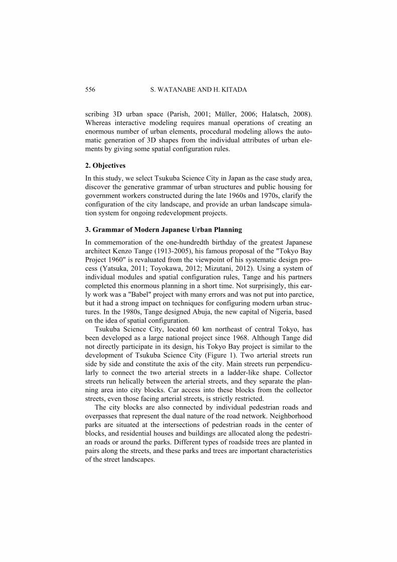
In commemoration of the one-hundredth birthday of the greatest Japanese architect Kenzo Tange (1913-2005), his famous proposal of the "Tokyo Bay Project 1960" is revaluated from the viewpoint of his systematic design pro-cess (Yatsuka, 2011; Toyokawa, 2012; Mizutani, 2012). Using a system of individual modules and spatial configuration rules, Tange and his partners completed this enormous planning in a short time. Not surprisingly, this ear-ly work was a "Babel" project with many errors and was not put into parctice, but it had a strong impact on techniques for configuring modern urban struc-tures. In the 1980s, Tange designed Abuja, the new capital of Nigeria, based on the idea of spatial configuration.
Tsukuba Science City, located 60 km northeast of central Tokyo, has been developed as a large national project since 1968. Although Tange did not directly participate in its design, his Tokyo Bay project is similar to the development of Tsukuba Science City (Figure 1). Two arterial streets run side by side and constitute the axis of the city. Main streets run perpendicu-larly to connect the two arterial streets in a ladder-like shape. Collector streets run helically between the arterial streets, and they separate the plan-ning area into city blocks. Car access into these blocks from the collector streets, even those facing arterial streets, is strictly restricted.
The city blocks are also connected by individual pedestrian roads and overpasses that represent the dual nature of the road network. Neighborhood parks are situated at the intersections of pedestrian roads in the center of blocks, and residential houses and buildings are allocated along the pedestri-an roads or around the parks. Different types of roadside trees are planted in pairs along the streets, and these parks and trees are important characteristics of the street landscapes.
GENERATIVE GRAMMAR OF MODERN JAPANESE CITY PLAN… 557
The hierarchical network of roads and the complete separation of cars and pedestrians are in accordance with the principles of modern urban plan-ning and are adaptable to current modeling methods. However, they do not always receive full support, because the spatial configuration characterizing Tsukuba Science City differs from that of other traditional cities in Japan.
Figure 1. Tokyo Bay Project 1960 (Tange, 1985), and Tsukuba Science City.
4. Grammar of Modern Japanese Public Housing
In Japan, buildings for public housing were constructed in large numbers and at low cost during the high economic growth period after World War II. These buildings are important elements that constitute and characterize the modern urban space, and their presence has had a great impact on the current landscape and environment. Although the spatial configuration of Japanese public housing originated in the highly systematic rules stated in the well-known "Type 51C" project proposed in 1951 (Suzuki, 2006), this housing has not been seriously studied in the field of architectural design computing, because it is of little interest from the viewpoint of architectural appearance.
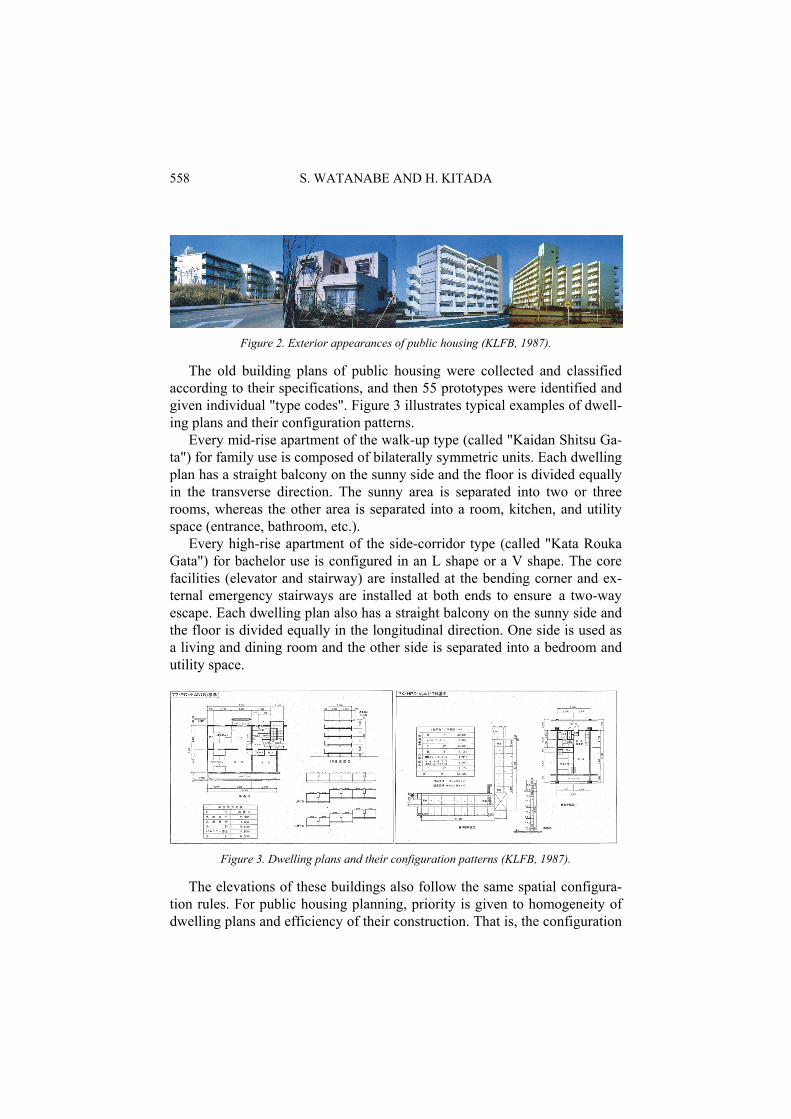
According to the "Summary of Housing Construction for National Gov-ernment Workers 1987" (KFLB, 1987), 747 buildings/7624 housing units were constructed in Tsukuba Science City as various types of public housing, such as detached houses, townhouses, duplex apartment buildings, and high-rise apartment buildings. They are divided into seven classes based on floor area. The housing has been rented to workers according to their job grade (Figure 2).
558 S. WATANABE AND H. KITADA
Figure 2. Exterior appearances of public housing (KLFB, 1987).
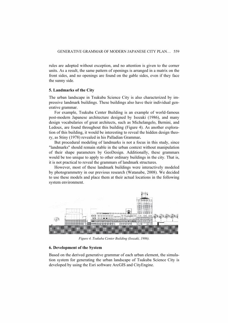
The old building plans of public housing were collected and classified according to their specifications, and then 55 prototypes were identified and given individual "type codes". Figure 3 illustrates typical examples of dwell-ing plans and their configuration patterns.
Every mid-rise apartment of the walk-up type (called "Kaidan Shitsu Ga-ta") for family use is composed of bilaterally symmetric units. Each dwelling plan has a straight balcony on the sunny side and the floor is divided equally in the transverse direction. The sunny area is separated into two or three rooms, whereas the other area is separated into a room, kitchen, and utility space (entrance, bathroom, etc.).
Every high-rise apartment of the side-corridor type (called "Kata Rouka Gata") for bachelor use is configured in an L shape or a V shape. The core facilities (elevator and stairway) are installed at the bending corner and ex-ternal emergency stairways are installed at both ends to ensure a two-way escape. Each dwelling plan also has a straight balcony on the sunny side and the floor is divided equally in the longitudinal direction. One side is used as a living and dining room and the other side is separated into a bedroom and utility space.
Figure 3. Dwelling plans and their configuration patterns (KLFB, 1987).
The elevations of these buildings also follow the same spatial configura-tion rules. For public housing planning, priority is given to homogeneity of dwelling plans and efficiency of their construction. That is, the configuration
GENERATIVE GRAMMAR OF MODERN JAPANESE CITY PLAN… 559
rules are adopted without exception, and no attention is given to the corner units. As a result, the same pattern of openings is arranged in a matrix on the front sides, and no openings are found on the gable sides, even if they face the sunny side.
5. Landmarks of the City
The urban landscape in Tsukuba Science City is also characterized by im-pressive landmark buildings. These buildings also have their individual gen-erative grammar.
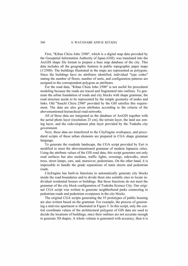
For example, Tsukuba Center Building is an example of world-famous post-modern Japanese architecture designed by Isozaki (1986), and many design vocabularies of great architects, such as Michelangelo, Bernini, and Ledoux, are found throughout this building (Figure 4). As another explora-tion of this building, it would be interesting to reveal the hidden design theo-ry, as Stiny (1978) revealed in his Palladian Grammar.
But procedural modeling of landmarks is not a focus in this study, since "landmarks" should remain stable in the urban context without manipulation of their shape parameters by GeoDesign. Additionally, these grammars would be too unique to apply to other ordinary buildings in the city. That is, it is not practical to reveal the grammars of landmark structures.
However, most of these landmark buildings were interactively modeled by photogrammetry in our previous research (Watanabe, 2008). We decided to use these models and place them at their actual locations in the following system environment.
Figure 4. Tsukuba Center Building (Isozaki, 1986).
6. Development of the System
Based on the derived generative grammar of each urban element, the simula-tion system for generating the urban landscape of Tsukuba Science City is developed by using the Esri software ArcGIS and CityEngine.
560 S. WATANABE AND H. KITADA
First, "Kiban Chizu Joho 2500", which is a digital map data provided by the Geospatial Information Authority of Japan (GSI), was translated into the ArcGIS shape file format to prepare a base map database of the city. This data includes all the geographic features in public topographic paper maps (1/2500). The buildings illustrated in the maps are represented as polygons. Since the buildings have no attributes identified, individual "type codes" stating the number of floors, number of units, and configuration patterns are assigned to the correspondent polygons as attributes.
For the road data, "Kiban Chizu Joho 2500" is not useful for procedural modeling because the roads are traced and fragmented into outlines. To gen-erate the urban foundation of roads and city blocks with shape grammar, the road structure needs to be represented by the simple geometry of nodes and links. Old "Suuchi Chizu 2500" provided by the GSI satisfies this require-ment. The data are also given attributes according to the criteria of the abovementioned hierarchical road networks.
All of these data are integrated as the database of ArcGIS together with the aerial photo layer (resolution 25 cm), the terrain layer, the land use zon-ing layer, and the redevelopment plan layer provided by the Tsukuba city government.
Next, these data are transferred to the CityEngine workspace, and proce-dural scripts of these urban elements are prepared in CGA shape grammar language.
To generate the roadside landscape, the CGA script provided by Esri is modified to meet the abovementioned grammar of modern Japanese cities. Using the attribute values of the GIS road data, this script generates not only road surfaces but also medians, traffic lights, crossings, sidewalks, street trees, street lamps, cars, and, moreover, pedestrians. On the other hand, it is impossible to handle the grade separations of main streets and pedestrian roads.
CityEngine has built-in functions to automatically generate city blocks inside the road boundaries and to divide them into suitable sites to locate in-dividual residential houses or buildings. But these functions do not meet the grammar of the city block configuration of Tsukuba Science City. Our origi-nal CGA script was written to generate neighborhood parks connecting to pedestrian roads and pedestrian overpasses in the city blocks.
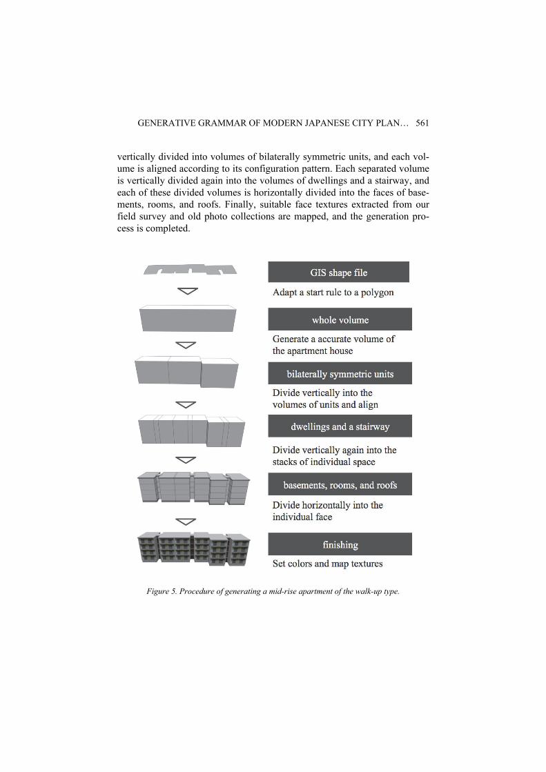
The original CGA scripts generating the 55 prototypes of public housing are also written based on the grammar. For example, the process of generat-ing a mid-rise apartment is illustrated in Figure 5. In this script, only the cen-tral coordinate values of the architectural polygons of GIS data are used to decide the locations of buildings, since their outlines are not accurate enough to generate 3D shapes. A whole volume is generated with accuracy, then it is
GENERATIVE GRAMMAR OF MODERN JAPANESE CITY PLAN… 561
vertically divided into volumes of bilaterally symmetric units, and each vol-ume is aligned according to its configuration pattern. Each separated volume is vertically divided again into the volumes of dwellings and a stairway, and each of these divided volumes is horizontally divided into the faces of base-ments, rooms, and roofs. Finally, suitable face textures extracted from our field survey and old photo collections are mapped, and the generation pro-cess is completed.
Figure 5. Procedure of generating a mid-rise apartment of the walk-up type.
562 S. WATANABE AND H. KITADA
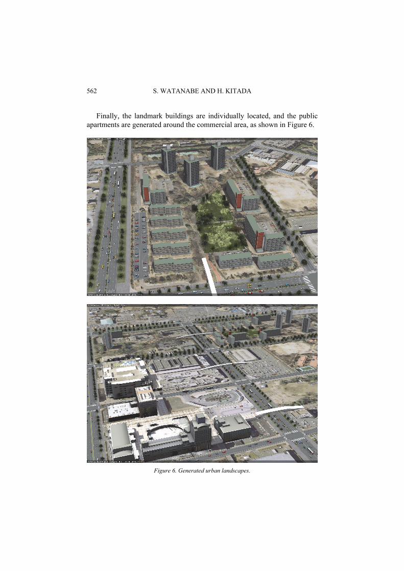
Finally, the landmark buildings are individually located, and the public apartments are generated around the commercial area, as shown in Figure 6.
Figure 6. Generated urban landscapes.
GENERATIVE GRAMMAR OF MODERN JAPANESE CITY PLAN… 563
7. Conclusion
All urban elements except landmarks can be represented as individual ob-jects automatically generated by the procedural CGA scripts of the genera-tive grammar, and the urban landscape of the city is reproduced successfully. If observed in detail, many generated urban objects differ from reality. Nev-ertheless, they can be manipulated by changing their attributes, such as hous-ing type, number of floors, width of roads, and type of street trees.
It is difficult to describe all the grammars derived from the survey since an adequate amount of "reserved words" have not yet been prepared in CGA shape grammar language. For example, it is impossible to describe the bot-tom-up process of recognizing and integrating patterns of elements. En-hancement of this language is expected.
As part of the search for financial resources to restore urban landscapes after the Great East Japan Earthquake, the Japanese government decided to close the public housing for government workers across the nation and cash out their assets within a few years. However, demolition of old public hous-ing buildings was partially executed in the past, and concerns are increasing about the spatial disconnection between the familiar environment cultivated over decades and the heterogeneous environment being redeveloped. In ad-dition, deterioration of the structures constructed in the high economic growth period is recognized as a social problem, and urban planning and de-sign with a long-term perspective is expected to make effective use of Ge-oDesign.
The collection of CGA scripts will be a fundamental source of GeoDe-sign for the redevelopment of modern Japanese cities.
Acknowledgements
The present study was supported by the "New Developments of Spatial Analysis Methods Combining Geographic Information Science and Urban Engineering" and "Theory and Exper-imental Study of Selecting, Consolidating, and Overhauling Aged Urban Infrastructures" Grants-in-Aid for Scientific Research (KAKENHI) in Japan.
References
Steinitz, C.: 2012, A Framework for Geodesign: Changing Geography by Design, ESRI Press, New York, 89–195.
McHarg, I.: 1969, Design with Nature, Parish, Y. I. H. and Müller, P.: 2001, Procedural Modeling of Cities, SIGGRAPH '01 Pro-
ceedings of the 28th annual conference on Computer graphics and interactive techniques, pp.301-308.
Müller, P., Wonka, P., Haegler, S., Ulmer, A., and Gool, L. V.: 2006, Procedural Modeling of Buildings, SIGGRAPH '06 ACM SIGGRAPH 2006 Papers, pp.614-623.
Halatsch, J., Kunze, A., and Schmitt, G.: 2008, Using Shape Grammars for Master Planning, Design Computing and Cognition DCC’08, Sprinter, 655-672.
564 S. WATANABE AND H. KITADA
Yatsuka, H.: 2011, Metabolism Nexus, Ohm Press, Tokyo, (in Japanese). Toyokawa, S.: 2012, Architectural Theories and Practices by Kenzo Tange Laboratory, Main-
stream of Postwar Japanese Architecture and Urban History, Ohm Press, Tokyo, (in Japa-nese).
Mizutani, A.: 2013, Revaluation and Application of Urban Design Method by Kenzo Tange Laboratory -focus on today's significance of their computational method, Doctoral Thesis of Shibaura Institute of Technology, (in Japanese).
Tange, K.: 1985, Ippon no enpitsu kara, Nihon Keizai Shimbun, Inc. (in Japanese). Suzuki, S.: 2006, White paper on 51C, my postwar history of architectural planning, SUMAI
Library Publishing Company. (in Japanese). KLFB (Kanto Local Financial Bureau of the Ministry of Finance): 1987, Summary of Hous-
ing Construction for National Government Workers 1987, (in Japanese). Mitchell, J. W.: 1990, Logic of Architecture, MIT Press, London. Stiny, G. and Mitchell, J.W.: 1978, The Palladian Grammar, Environment and Planning B 5,
no.1, 5-18 Stiny, G.: 2006, SHAPE, Talking about Seeing and Doing, The MIT Press. Watanabe, S. and Nishikawa, Y.: 2008, Production Method of Accurate 3D Urban Models
with Digital Photogrammetry, Proceedings of the 13th Conference on Computer-Aided Design Research in Asia (CAADRIA 2008), Cheng Mai, 564-571.
Isozaki, A.: 1986, Arata Isozaki's detail drawings, Details of Tsukuba Center Building, SHO-KOKUSHA Publishing Co., Ltd.


![2. Generative Grammar [Kompatibilitätsmodus]x4diho/Grammar and Language Use 2.pdf · In generative grammar, ... • Morphology • Syntax ... -> What kind of methodology do generative](https://static.fdocuments.us/doc/165x107/5ae3ab2e7f8b9a5b348db8b6/2-generative-grammar-kompatibilittsmodus-x4dihogrammar-and-language-use-2pdfin.jpg)