
GENERAL BIOLOGICAL RESOURCES AND MSHCP COMPLIANCE … B - MSHCP... · · 2010-03-22lsa...
30
GENERAL BIOLOGICAL RESOURCES AND MSHCP COMPLIANCE REPORT RIVERSIDE PUBLIC UTILITIES SUBTRANSMISSION PROJECT 1533 FEEDER LOAD RELIEF CITY OF RIVERSIDE RIVERSIDE COUNTY, CALIFORNIA December 1, 2009
Transcript of GENERAL BIOLOGICAL RESOURCES AND MSHCP COMPLIANCE … B - MSHCP... · · 2010-03-22lsa...

G E N E R A L B I O L O G I C A L R E S O U R C E S A N D M S H C P C O M P L I A N C E R E P O R T
RIVERSIDE PUBLIC UTILITIES SUBTRANSMISSION PROJECT
1533 FEEDER LOAD RELIEF
CITY OF RIVERSIDE
RIVERSIDE COUNTY, CALIFORNIA
December 1, 2009

G E N E R A L B I O L O G I C A L R E S O U R C E S A N D M S H C P C O M P L I A N C E R E P O R T
RIVERSIDE PUBLIC UTILITIES SUBTRANSMISSION PROJECT
1533 FEEDER LOAD RELIEF
CITY OF RIVERSIDE
RIVERSIDE COUNTY, CALIFORNIA
Prepared for:
Riverside Public Utilities 3901 Orange Street
Riverside, California 92501
Prepared by:
LSA Associates, Inc. 1500 Iowa Avenue, Suite 200 Riverside, California 92507
(951) 781-9310
LSA Project No. CTR0901
December 1, 2009

R:\CTR0901\Biology\CTR0901 MSHCP Compliance Rpt_Draft.doc (12/1/2009) i
TABLE OF CONTENTS
EXECUTIVE SUMMARY.................................................................................................................... 1 1.0 INTRODUCTION..................................................................................................................... 2 2.0 PROJECT DESCRIPTION AND LOCATION ........................................................................ 2 3.0 REGULATORY BACKGROUND........................................................................................... 2
3.1 JURISDICTIONAL WATERS AND STREAMBEDS ............................................... 2 3.2 MSHCP COMPLIANCE ............................................................................................. 4 3.3 CALIFORNIA ENVIRONMENTAL QUALITY ACT COMPLIANCE.................... 5
4.0 METHODS................................................................................................................................ 7
4.1 LITERATURE REVIEW............................................................................................. 7 4.2 FIELD SURVEYS ....................................................................................................... 7
5.0 RESULTS.................................................................................................................................. 7
5.1 EXISTING AND ADJACENT LAND USE................................................................ 7 5.2 ELEVATION, TOPOGRAPHY, AND SOILS............................................................ 7 5.3 VEGETATION, SOILS, AND DISTURBANCE........................................................ 8 5.4 WILDLIFE ................................................................................................................... 8 5.5 POTENTIAL JURISDICTIONAL WETLANDS AND STREAMBEDS................... 8
6.0 MSHCP COMPLIANCE ........................................................................................................ 11
6.1 OBJECTIVES FOR AREA PLAN AND SUBUNIT ................................................ 11 6.2 OBJECTIVES FOR CRITERIA CELLS ................................................................... 11 6.3 OVERALL CONSISTENCY WITH MSHCP AND RESERVE ASSEMBLY
CRITERIA ................................................................................................................. 13 7.0 CEQA COMPLIANCE ........................................................................................................... 15
7.1 ADOPTED HABITAT CONSERVATION PLANS ................................................. 15 7.2 THREATENED AND ENDANGERED SPECIES ................................................... 15 7.3 OTHER SPECIAL INTEREST SPECIES ................................................................. 15 7.4 WILDLIFE MOVEMENT, CORRIDORS, AND NURSERY SITES ...................... 19 7.5 NATURAL COMMUNITIES OF INTEREST.......................................................... 19 7.6 WETLANDS AND OTHER JURISDICTIONAL AREAS....................................... 19 7.7 LOCAL POLICIES AND ORDINANCES PROTECTING BIOLOGICAL
RESOURCES............................................................................................................. 20 7.8 INDIRECT EFFECTS................................................................................................ 20 7.9 CUMULATIVE EFFECTS........................................................................................ 20
8.0 RECOMMENDATIONS ........................................................................................................ 21 9.0 REFERENCES........................................................................................................................ 22
R:\CTR0901\Biology\CTR0901 MSHCP Compliance Rpt_Draft.doc (12/1/2009) ii
FIGURES, TABLES, AND APPENDIX
FIGURES 1: Regional Location, Study Area and Biological Resources Map ............................................... 3 1A: Site Photographs........................................................................................................................ 4 TABLES A: MSHCP Project Review Checklist............................................................................................ 6 B: Special Interest Species Potentially Occurring in the Project Vicinity that are not
Adequately Covered by the MSHCP....................................................................................... 10 APPENDIX A: PLANT AND ANIMAL SPECIES OBSERVED

L S A A S S O C I A T E S , I N C . G E N E R A L B I O L O G I C A L R E S O U R C E S A N D M S H C P C O M P L I A N C E R E P O R T D E C E M B E R 2 0 0 9 R I V E R S I D E P U B L I C U T I L I T I E S S U B T R A N S M I S S I O N P R O J E C T 1 5 3 3 F E E D E R L O A D R E L I E F
R:\CTR0901\Biology\CTR0901 MSHCP Compliance Rpt_Draft.doc (12/1/2009) 1
EXECUTIVE SUMMARY LSA Associates, Inc. (LSA) was retained by the City of Riverside Public Utilities Department (RPU) to prepare necessary biological reports to comply with the Western Riverside County Multiple Species Habitat Conservation Plan (MSHCP) for the Orangecrest-Overlook Feeder Project (Project). The proposed project alignment starts at the Orangecrest Substation located at the southeast corner of Trautwein Avenue and John F. Kennedy Boulevard. From the substation, the new cable will be routed through existing underground conduits north along Trautwein Avenue for 6,500 feet and continuing north along Alessandro Boulevard for approximately 5,200 feet to Overlook Parkway. The underground cable will then continue west into a new underground conduit system within the street right-of-way along Overlook Parkway for approximately 1,300 feet. Construction plans include an overhead span of 350 feet over the eastern arroyo located near the end of the pavement at Overlook Parkway, which will then continue west underground through existing structures for approximately 1,000 feet past Via Vista Drive to the second arroyo. At the second arroyo, an additional overhead span of 600 feet will be constructed to clear the second arroyo and then drop underground into existing underground structures located within the Overlook Parkway right-of-way for approximately 300 feet to Crystal View Terrace where the new cable will tie into existing facilities. The project site is located within the MSHCP Cities of Riverside and Norco Area Plan. The project is not located within a planning area subunit or Criteria Cell and is therefore not subject to MSHCP criteria for conservation. The project site is located within the MSHCP Burrowing Owl Survey Area but is not within a Criteria Area Species Survey Area (CASSA) or Narrow Endemic Plant Species Survey Area (NEPSSA). A burrowing owl habitat suitability assessment (HSA) has been conducted. Focused burrowing owl surveys are required due to the presence of suitable habitat in the project area. The study area contains riparian/riverine habitat and potential U.S. Army Corps of Engineers (ACOE) and California Department of Fish and Game (CDFG) jurisdictional areas. However, permanent impacts to these areas will be avoided through project design. It is recommended that overland project activities be conducted outside of the avian nesting season (February 15 to August 15) in order to avoid impacts to nesting birds including the state and federally endangered least Bell’s vireo (Vireo bellii pusillus) and southwestern willow flycatcher (Empidonax traillii traillii). If project activities are planned within the riverine/riparian areas, a focused riparian bird survey will be required in order to avoid potential impacts to these species.

L S A A S S O C I A T E S , I N C . G E N E R A L B I O L O G I C A L R E S O U R C E S A N D M S H C P C O M P L I A N C E R E P O R T D E C E M B E R 2 0 0 9 R I V E R S I D E P U B L I C U T I L I T I E S S U B T R A N S M I S S I O N P R O J E C T 1 5 3 3 F E E D E R L O A D R E L I E F
R:\CTR0901\Biology\CTR0901 MSHCP Compliance Rpt_Draft.doc (12/1/2009) 2
1.0 INTRODUCTION LSA Associates, Inc. (LSA) was retained to conduct a general biological resources assessment at the proposed Riverside Public Utilities Subtransmission Project located near Trautwein Avenue, Alessandro Boulevard, Overlook Parkway and Via Vista Drive in the City of Riverside (City), California. The proposed project includes installation of an electric transmission line for the Riverside Public Utilities (RPU) Department. LSA biologists reviewed relevant background information and visited the site to assess existing biological resources and determine potential project impacts on these resources. 2.0 PROJECT LOCATION AND DESCRIPTION An initial project route has been identified through system studies performed by RPU. The route starts at the Orangecrest Substation located at the southeast corner of Trautwein Avenue and John F. Kennedy Boulevard. From the substation, the new cable will be routed through existing underground conduits north along Trautwein Avenue for 6,500 feet and continue within existing underground conduit north along Alessandro Boulevard for approximately 5,200 feet to Overlook Parkway. The underground cable will then continue west into a new underground conduit system within the street right-of-way along Overlook Parkway for approximately 1,300 feet. From there, an overhead span of 350 feet will be constructed over the eastern arroyo located near the end of the pavement at Overlook Parkway. Beyond this, the cable will continue west underground through existing structures for approximately 1,000 feet past Via Vista Drive to the second arroyo. At the second arroyo, an additional overhead span of 600 feet will be constructed to clear the second arroyo. The cable will then be located underground in existing underground structures located within the Overlook Parkway right-of-way for approximately 300 feet to Crystal View Terrace. The new cable will tie into existing facilities at Crystal View Terrace (Figure 1). 3.0 REGULATORY BACKGROUND 3.1 Jurisdictional Waters and Streambeds The U.S. Army Corps of Engineers (ACOE), under Section 404 of the Federal Clean Water Act (CWA), regulates discharges of dredged or fill material into “waters of the United States.” These waters include wetlands and non-wetland bodies of water that meet specific criteria, including a connection to interstate or foreign commerce. This connection may be direct (through a tributary system linking a stream channel with traditional navigable waters used in interstate or foreign commerce) or it may be indirect (through a connection identified in ACOE regulations). The ACOE typically regulates as non-wetland waters of the U.S. any body of water displaying an “ordinary high water mark.” In order to be considered a jurisdictional wetland under Section 404, an area must possess hydrophytic vegetation, hydric soils, and wetland hydrology. On January 9, 2001, the United States Supreme Court narrowly limited the ACOE jurisdiction of “non-navigable, isolated, intrastate” waters based solely on the use of such waters by migratory birds. The Court ruling derives from the case Solid Waste Agency of Northern Cook County (SWANCC) v. U.S. Army Corps of Engineers, No. 99-1178. The Supreme Court, in a 5–4 decision, determined the ACOE exceeded its statutory authority by asserting CWA jurisdiction over an abandoned sand and gravel pit in northern Illinois that provides habitat for migratory birds.

OVERLOOK PKWY
VIA VISTA DRIVE
Arroyo
Arroyo
OVERLOOK PKWY
OVERLOOK
PKWY
VIA VI
STA
DRI
VE
!1
!2
!
3
!
4
SOURCE: AirPhotoUSA, 2009; City of Riverside, Department of Public Utilities, (08/31/09).I:\CTR0901\Reports\Bio_Res\fig1_Study_Area_Bio_Photo_Loc.mxd (12/01/09)
1533 Feeder Load Relief ProjectRegional Location, Study Area and Biological Resources Map
FIGURE 1
0 100 200
Feet
S!!NStudy AreaNon-Native GrasslandRiparian ScrubRiparian Woodland
?l
?q
A»A»
!"a$ A¦
%&g(
!"$
A¥
?q
!"a$
!"a$
%&h(
%&h(!"$
Pacific Ocean
A
Riverside County
San Bernardino County
Orange County
San Diego County
Los Angeles County
Regional Location
Project Area
S!!N0 10 20
Miles
!1 Photograph location and direction taken

Photograph 1:View of riparian woodland canopy in western portion of site, towards southwest.
Photograph 2:View of nonnative grassland with remnants of Riversidian sage scrub in western portion of site, towards southwest.
FIGURE 1A
Site Photographs
1533 Feeder Load Relief Project
I:\CTR0901\Reports\Bio_Res\Fig2A-B_Photos.cdr (12/01/09)

L S A A S S O C I A T E S , I N C . G E N E R A L B I O L O G I C A L R E S O U R C E S A N D M S H C P C O M P L I A N C E R E P O R T D E C E M B E R 2 0 0 9 R I V E R S I D E P U B L I C U T I L I T I E S S U B T R A N S M I S S I O N P R O J E C T 1 5 3 3 F E E D E R L O A D R E L I E F
R:\CTR0901\Biology\CTR0901 MSHCP Compliance Rpt_Final.doc (12/1/2009) 5
In 2006, the Supreme Court in the consolidated cases Rapanos v. United States and Carabell v. Army Corps of Engineers (Rapanos) addressed CWA jurisdiction over wetlands adjacent or abutting navigable, non-navigable and ephemeral tributaries; jurisdiction over permanent and relatively permanent non-navigable tributaries (126. CT.2208 (2006), 33 U.S.C. §1251 et seq.). The CWA does not assert jurisdiction over upland erosional features, gullies, and roadside ditches that have infrequent, low volume, and short duration of water flow. In addition, ACOE uses a significant nexus analysis. Application of this standard will involve a comprehensive review of the tributary flow characteristics, functions of the tributary, and functions of any adjacent wetlands. The analysis involves completion of a seven-page “Approved Jurisdiction Form.” The ACOE uses the standard to determine if the tributary or wetland significantly affects the hydrological, ecological, chemical, physical, and biological integrity of the downstream navigable water. Additional information is provided in United States Environmental Protection Agency (EPA) memorandum titled “Clean Water Act Jurisdiction Following the U.S. Supreme Court’s Decision in Rapanos v. United States & Carabell v. United States,” dated June 5, 2007 (ACOE 2007), and also the U.S. Army Corps of Engineers Jurisdictional Determination Form Instructional Guidebook (ACOE and EPA 2007). The California Department of Fish and Game (CDFG), under Sections 1600 et seq. of the California Fish and Game Code, regulates alterations to lakes, rivers, and streams. A stream is defined by the presence of a channel bed and banks, and at least an occasional flow of water. The CDFG also regulates habitat associated with the streambed, such as wetland, riparian shrub, and woodlands. The Regional Water Quality Control Board (RWQCB) is responsible for the administration of Section 401 of the CWA, through water quality certification of any activity that may result in a discharge to jurisdictional waters of the U.S. The RWQCB may also regulate discharges to “waters of the State,” including wetlands, under the California Porter-Cologne Water Quality Control Act. 3.2 MSHCP Compliance The Western Riverside County Multiple Species Habitat Conservation Plan (MSHCP) provides for the assembly of a Conservation Area consisting of Core Areas and Linkages for the conservation of Covered Species (Riverside County 2003). Covered Species are 146 species of plants and animals of various federal and state listing status. The Conservation Area is to be assembled from portions of the MSHCP Criteria Area, which consists of quarter-section (i.e., 160-acre) Criteria Cells, each with specific criteria for the species conservation within that cell. The MSHCP provides an incentive-based program, the Habitat Evaluation and Acquisition Negotiation Strategy (HANS) for adding land to the MSHCP Conservation Area. If it is determined that all or a portion of the property is needed for inclusion in the MSHCP Conservation Area, then various incentives may be available to the property owner in exchange for the conveyance of a property interest. The MSHCP requires focused surveys for certain plant, amphibian, owl, and mammal species for project sites located within designated plant and animal survey areas when potential suitable habitat is present. Surveys for Delhi Sands giant flower-loving fly (Rhaphiomidas terminatus abdominalis) may be required in areas having Delhi soils. Surveys for listed riparian birds are required when suitable riparian habitat is present, and surveys for listed fairy shrimp species are required when vernal pools or other suitable habitat are? present.

L S A A S S O C I A T E S , I N C . G E N E R A L B I O L O G I C A L R E S O U R C E S A N D M S H C P C O M P L I A N C E R E P O R T D E C E M B E R 2 0 0 9 R I V E R S I D E P U B L I C U T I L I T I E S S U B T R A N S M I S S I O N P R O J E C T 1 5 3 3 F E E D E R L O A D R E L I E F
R:\CTR0901\Biology\CTR0901 MSHCP Compliance Rpt_Final.doc (12/1/2009) 6
Projects located in proximity to the MSHCP Conservation Area may result in edge effects that could adversely affect biological resources within the MSHCP Conservation area. MSHCP Urban/Wildlands Interface Guidelines (MSHCP Section 6.1.4) are intended to reduce such indirect effects. 3.3 California Environmental Quality Act Compliance (CEQA) 3.3.1: Adopted Habitat Conservation Plans. Section 10(a)(2)(A) of the 1973 Federal Endangered Species Act (FESA) requires the preparation of a habitat conservation plan (HCP) for incidental take of threatened or endangered species when there is no federal agency involvement in a project. Continuing land development may cause incidental take of listed species and, therefore, HCPs have been prepared for areas within western Riverside County. The MSHCP and the Stephens’ Kangaroo Rat Habitat Conservation Plan are the principal habitat conservation plans in western Riverside County. The U.S. Fish and Wildlife Service (USFWS) regional office maintains a current list of habitat conservation plans for the southern California region. 3.3.2: Threatened and Endangered Species. The USFWS or CDFG may list species as threatened or endangered under the FESA or California Endangered Species Act (CESA), respectively. The USFWS can designate critical habitat that identifies specific areas, either occupied or unoccupied, that are essential to the conservation of a listed species. Critical habitat areas may require special management considerations or protections. The USFWS and CDFG have issued permits for the take of most threatened and endangered species within the MSHCP Plan Area. The MSHCP and related EIR/EIS address impacts to these species. However, if a project has the involvement of a federal agency, that agency is required to address impacts to listed species and critical habitat by consulting with the USFWS. The USFWS has indicated in the permit issued for the MSHCP that, in such cases, the consultation will be expedited and that no restrictions will be imposed on the project beyond those specified in the MSHCP. 3.3.3: Other Special Interest Species. Other special interest species may occur on the proposed project site. The CDFG, USFWS, local agencies, and special interest groups, such as the California Native Plant Society (CNPS), maintain lists of species that they consider to be in need of monitoring. Legal protection for special interest species varies widely. 3.3.4: Wildlife Movement, Corridors, and Nursery Sites. Wildlife movement includes seasonal migration along corridors, as well as daily movements for foraging. Migration corridors may include areas of unobstructed movement of deer, riparian corridors providing cover for migrating birds, routes between breeding waters and upland habitat for amphibians, and between roosting and feeding areas for birds. During the avian nesting season (typically February 1 through August 31), large trees (greater than 15 to 70 feet in height) may be used by hawks, ravens, or other large birds for nesting. Trees, shrubs, and other vegetation may provide nest sites for smaller birds, and burrowing owls may nest in abandoned ground squirrel burrows, pipes, or similar features. Most birds and their active nests are protected

L S A A S S O C I A T E S , I N C . G E N E R A L B I O L O G I C A L R E S O U R C E S A N D M S H C P C O M P L I A N C E R E P O R T D E C E M B E R 2 0 0 9 R I V E R S I D E P U B L I C U T I L I T I E S S U B T R A N S M I S S I O N P R O J E C T 1 5 3 3 F E E D E R L O A D R E L I E F
R:\CTR0901\Biology\CTR0901 MSHCP Compliance Rpt_Final.doc (12/1/2009) 7
from “take” (meaning destruction, pursuit, possession, etc.) under the Migratory Bird Treaty Act (USFWS 2002) and/or Sections 3503–3801 of the California Fish and Game Code (CDFG 2007). Activities that cause destruction of active nests, or that cause nest abandonment and subsequent death of eggs or young, may constitute violations of one or both of these laws. Removal of vegetation shall be conducted outside of nesting season to avoid impacts to nesting birds. 3.3.5: Natural Communities of Interest. Riparian habitats, oak woodlands, and vernal pools are among the natural communities of interest to the CDFG. Coastal sage scrub is not considered a sensitive natural community unless it is occupied by coastal California gnatcatcher (Polioptila californica californica) or has been designated as critical habitat for the California gnatcatcher by the USFWS. 3.3.6: Wetlands. Wetlands as defined by the ACOE must possess hydrophytic vegetation, hydric soils, and wetland hydrology under normal circumstances. In order to be considered a vernal pool under the MSHCP, a depression must also meet these three wetland criteria. 3.3.7: Local Policies and Ordinances Protecting Biological Resources. City and County General Plans and development ordinances may include regulations or policies governing biological resources. For example, policies may include tree preservation, locally designated species survey areas, local species of interest, and significant ecological areas (Riverside County Planning Department 2006). 3.3.8: Direct Effects. Direct effects are impacts that occur at the same time and in the location of the actual construction work. The associated impacts with construction activities have the potential to result in the destruction, disturbance, and removal of plants, animals, watercourses, and natural communities. 3.3.9: Indirect Effects. Indirect effects are impacts caused by the project action but are later in time or farther in distance from the actual construction work. Indirect effects include growth inducement, changes in land use patterns, increased human intrusion, population growth, noise, and impacts to air quality, wind movements, water quality, hydrology, plant communities, wildlife movement, and regional ecosystems. 3.3.10: Cumulative Effects. According to Section 15130 of the CEQA Guidelines (Consulting Engineers and Land Surveyors of California 2007), cumulative impacts refer to incremental effects of an individual project when viewed in connection with the effects of past projects, current projects, and probable future projects.
L S A A S S O C I A T E S , I N C . G E N E R A L B I O L O G I C A L R E S O U R C E S A N D M S H C P C O M P L I A N C E R E P O R T D E C E M B E R 2 0 0 9 R I V E R S I D E P U B L I C U T I L I T I E S S U B T R A N S M I S S I O N P R O J E C T 1 5 3 3 F E E D E R L O A D R E L I E F
R:\CTR0901\Biology\CTR0901 MSHCP Compliance Rpt_Final.doc (12/1/2009) 8
4.0 METHODS 4.1 Literature Review A literature review was conducted to determine the existence or potential occurrence of special-status plant and animal species on the project site and in the project vicinity. Database records for the Riverside East, California; Riverside West, California; Steele Peak, California; and Lake Mathews, California U.S. Geological Survey (USGS) 7.5-minute quadrangles were searched on October 28, 2009, using the CDFG Natural Diversity Data Base Rarefind 3 application (version 3.1.0, dated August 30, 2009) and the CNPS Electronic Inventory of Rare and Endangered Vascular Plants of California (online edition, v7-09d, 2009, http://www.cnps.org/inventory). An aerial photograph (AirPhoto USA 2008) was reviewed and Geographic Information Systems (GIS) software generated maps of USFWS designated critical habitats (USFWS 1994, 2005, 2006, 2007, and 2008) were used to determine the locations of critical habitats relative to the project site. Volume 1, Parts 1 and 2 of the Western Riverside County Multiple Species Habitat Conservation Plan were also used to prepare the biological resources report. Soil information was taken from Soil Survey of Western Riverside Area, California (Soil Conservation Service 1971) and electronic data provided by Soil Data Mart (NRCS 2003). 4.2 Field Surveys The general biological resources assessment included a site visit on November 9, 2009, by LSA Senior Biologist Sarah Barrera. An HSA for burrowing owl (Athene cunicularia hypugaea) was conducted at this time. Field surveys were conducted following applicable survey protocols or guidelines for each species. 5.0 RESULTS 5.1 Existing and Adjacent Land Use The majority of the study area is currently developed as the existing Overlook right-of-way. Paved portions of the Overlook Parkway right-of-way were not included in the study area for the biological resources assessment. The study area is discussed in two sections: the eastern portion, located approximately 1,000 feet northeast of the intersection of Overlook Parkway and Via Vista Drive, and the western portion, located immediately west of the intersection of Overlook Parkway and Via Vista Drive (Figure 1). Adjacent land uses include single-family residences and small areas of open space. 5.2 Elevation and Topography The site elevation ranges between approximately 1,485 to 1,375 feet above mean sea level (amsl). The site is generally flat in the eastern portion. The western portion is highest on the east side and slopes toward the east to its lowest point in a riverine/riparian area.

L S A A S S O C I A T E S , I N C . G E N E R A L B I O L O G I C A L R E S O U R C E S A N D M S H C P C O M P L I A N C E R E P O R T D E C E M B E R 2 0 0 9 R I V E R S I D E P U B L I C U T I L I T I E S S U B T R A N S M I S S I O N P R O J E C T 1 5 3 3 F E E D E R L O A D R E L I E F
R:\CTR0901\Biology\CTR0901 MSHCP Compliance Rpt_Final.doc (12/1/2009) 9
5.3 Soils, Vegetation, and Disturbance Mapped soils on the site are Cieneba sandy loam, Cieneba rocky sandy loam, Fallbrook sandy loam, Hanford coarse sandy loam, and Vista coarse sandy loam (Soil Survey for Western Riverside Area, California, A.A. Knecht 1971). The study area is undeveloped but much of the habitat is disturbed due to impacts from adjacent land uses. Several large boulders have been placed on the site on the west side, adjacent to Overlook Parkway. Vegetation communities identified on site include nonnative grassland (NNG), riparian scrub, and riparian woodland. NNG is the dominant vegetation community and occurs at the tops of the slopes in both the eastern and western portions of the study area. It is dominated by red brome (Bromus madritensis ssp. rubens), common fiddleneck (Amsinkia menziesii), tree tobacco (Nicotiana glauca), California buckwheat (Eriogonum fasciculatum), and California encelia (Encelia californica). The NNG contains remnants of Riversidean sage scrub, which was likely the dominant plant community prior to disturbance. There is a small area of disturbed riparian scrub located within a wash (arroyo) in the eastern portion of the study area. The riparian scrub is dominated by arroyo willow (Salix lasiolepis), mule fat (Baccharis salicifolia), tamarisk (Tamarix sp.), and California encelia. Riparian woodland occurs within the streambed near the center of the western portion of the study area. The tree canopy within the riparian woodland is dominated by arroyo willow, Goodding’s black willow (Salix gooddingii), and Fremont’s cottonwood (Populus fremontii). The understory is dominated by shrub and herbaceous species including cattails (Typha sp.), stinging nettle (Urtica dioica), and mule fat. Land cover, soils, and site photographs are shown in Figures 2 and 2A. A complete list of plant species observed on the site is included in Appendix A. 5.4 Wildlife Wildlife common to disturbed and riparian areas was observed, including black phoebe (Sayornis nigricans), house finch (Carpodacus mexicanus), lesser goldfinch (Carduelis psaltria), song sparrow (Melospiza melodia), yellow-rumped warbler (Dendroica coronata), Nuttall’s woodpecker (Picoides nuttallii), Audubon’s cottontail (Sylvilagus audubonii), and coyote (Canis latrans). A complete list of wildlife species observed on the site is included in Appendix A. 5.5 Potential Jurisdictional Wetlands and Streambeds Any activities resulting in fill, discharge, or alteration of a lake, river, or streambed are subject to jurisdiction by the CDFG, ACOE, and/or RWQCB. The stream, streambed, and associated riparian vegetation in the western portion of the study area are subject to the jurisdiction of CDFG, ACOE, and RWQCB. Additionally, there are two eroded washes in the eastern portion of the study area that are potentially subject to the jurisdiction of CDFG, ACOE, and/or RWQCB. A formal jurisdictional delineation was not conducted at the time of the survey as impacts to these areas are not anticipated. If impacts to these areas are proposed, a jurisdictional delineation will be required to determine the extent of jurisdictional areas within the study area.

L S A A S S O C I A T E S , I N C . G E N E R A L B I O L O G I C A L R E S O U R C E S A N D M S H C P C O M P L I A N C E R E P O R T D E C E M B E R 2 0 0 9 R I V E R S I D E P U B L I C U T I L I T I E S S U B T R A N S M I S S I O N P R O J E C T 1 5 3 3 F E E D E R L O A D R E L I E F
R:\CTR0901\Biology\CTR0901 MSHCP Compliance Rpt_Final.doc (12/1/2009) 10
The findings and conclusions presented in this report, including the location and extent of wetlands and other waters subject to regulatory jurisdiction, represent the professional opinion of LSA. These findings and conclusions should be considered preliminary until verified by the resource agencies. 6.0 MSHCP COMPLIANCE The study area is located within the MSHCP Cities of Riverside and Norco Area Plan but is not within an MSHCP Criteria Cell (Figure 3). Required species survey areas for the study area were identified by conducting a search on the Riverside County Integrated Project (RCIP) Conservation Summary Report Generator. The site is located within the burrowing owl survey area but is not located within and survey areas for CASSA or NEPSSA species. The study area is not located within areas identified as existing or proposed cores or linkages. Table A summarizes conservation criteria associated with Criteria Area Cell 5131 and a review of general conservation requirements identified in Volume 1 of the MSHCP. This table summarizes the MSHCP Project Review Checklist to determine conservation measures and surveys necessary for MSHCP Compliance. Table A: MSHCP Project Review Checklist
Yes No Is the project located in a Criteria Area or Public/Quasi-Public Land? Is the project located in Criteria Area Plant Survey Area? Is the project located in Criteria Area Amphibian Survey Area? Is the project located in Criteria Area Mammal Survey Area? Is the project located adjacent to MSHCP Conservation Areas? Is the project located in Narrow Endemic Plant Species Survey Area? Are riverine/riparian/wetland habitats or vernal pools present? Is the project located in Burrowing Owl Survey Area? 6.1 Objectives for Area Plan and Subunit The project site is located within the MSHCP Area Plan within the Cities of Riverside and Norco. This Area Plan is divided into two Subunits. For each Subunit, target conservation acreages are established along with a description of the Planning Species, Biological Issues and Considerations, and Criteria for each Subunit. However, the study area is not located within one of these Subunits and, therefore, there are no specific conservation objectives identified for the study area. 6.2 Objectives for Criteria Cells The study area is not located within any Criteria Cells.

L S A A S S O C I A T E S , I N C . G E N E R A L B I O L O G I C A L R E S O U R C E S A N D M S H C P C O M P L I A N C E R E P O R T D E C E M B E R 2 0 0 9 R I V E R S I D E P U B L I C U T I L I T I E S S U B T R A N S M I S S I O N P R O J E C T 1 5 3 3 F E E D E R L O A D R E L I E F
R:\CTR0901\Biology\CTR0901 MSHCP Compliance Rpt_Final.doc (12/1/2009) 11
6.3 Overall Consistency with MSHCP and Reserve Assembly Criteria Since the study area is not located within any Criteria Cells, it is not identified for potential use for the MSHCP Reserve Assembly. Therefore, use of the project site as proposed will not conflict with MSHCP conservation objectives for the area. 6.3.1: Cores and Linkages. A Linkage is a connection between Core Areas with adequate size, configuration, and vegetation characteristics to generally provide for “Live-In” habitat and/or provide for genetic flow for identified planning species. A Core is a block of habitat that supports the life history requirements of Covered Species. The proposed project is not located within or adjacent to any areas identified as a Linkage or Core Area. 6.3.2: Planning Species. The study area is not located within a designated planning area subunit and does not have any identified planning species. Therefore, impacts will not occur to any planning species. 6.3.3: Riparian/Riverine and Vernal Pool Requirements. Riparian/riverine areas are lands that contain habitat dominated by trees, shrubs, and persistent emergents, which occur close to or depend upon soil moisture from a nearby water source; or areas with fresh water flowing during all or a portion of the year. Unvegetated drainages (ephemeral streams) may be included if alterations to that drainage have the potential to affect Covered Species and Conservation Areas. The MSHCP requires focused surveys for sensitive riparian bird species when suitable riparian habitat is present and surveys for sensitive fairy shrimp species when vernal pools or other suitable habitat is present. The study area contains approximately 1.16 acres of riparian/riverine habitat in the western portion of the site and approximately 0.10 acres in the eastern portion of the site. The MSHCP requires analysis of project impacts to riparian/riverine areas through the preparation of a Determination of Biological Superior or Equivalent Preservation (DBESP). However, the proposed project will avoid permanent impacts to riparian/riverine habitat. No permanent structures will be placed in the riparian/riverine areas. Since no permanent impacts to riparian/riverine areas within the study area are expected, a DBESP is not anticipated to be required for the project. Mitigation measures as discussed in the MSHCP will be implemented in order to avoid potential temporary impacts to riparian/riverine areas and associated sensitive species. The riparian woodland in the western portion of the site provides suitable habitat for southwestern willow flycatcher and least Bell’s vireo. In order to avoid potential impacts to these species as a result of temporary project impacts, it is recommended that construction activities take place outside of the avian nesting season (February 15–August 31). If construction is scheduled during the avian nesting season, focused surveys for riparian birds will be required prior to project activities within and/or adjacent to riparian/riverine areas. If these species are found on site during riparian bird surveys, a DBESP would be required to analyze and mitigate for impacts to these species as a result of construction activities conducted during the nesting season. No vernal pools or similar habitats suitable for special interest fairy shrimp species are present on the project site; therefore, no surveys for fairy shrimp species will be required.

L S A A S S O C I A T E S , I N C . G E N E R A L B I O L O G I C A L R E S O U R C E S A N D M S H C P C O M P L I A N C E R E P O R T D E C E M B E R 2 0 0 9 R I V E R S I D E P U B L I C U T I L I T I E S S U B T R A N S M I S S I O N P R O J E C T 1 5 3 3 F E E D E R L O A D R E L I E F
R:\CTR0901\Biology\CTR0901 MSHCP Compliance Rpt_Final.doc (12/1/2009) 12
6.3.4: Narrow Endemic and Criteria Area Plant Species Survey Area. The study area is not within any Narrow Endemic or Criteria Area Plant Species Survey Areas and no NEPSSA or CASSA surveys are required. 6.3.5: Burrowing Owl. The majority of the project site is within the MSHCP burrowing owl survey area. Burrowing owls are found in open, dry grasslands, agricultural and range lands, and desert habitats often associated with burrowing animals. They can also inhabit grass, forb, and shrub stages of pinyon, and ponderosa pine habitats. They nest in abandoned burrows of ground squirrels or other animals, in pipes, under piles of rock or debris, and in other similar features. Sites within the MSHCP burrowing owl survey area require a burrowing owl HSA, and, if suitable, focused burrowing owl surveys. An HSA was conducted at the time of the general biological resources survey in November 2009, according to the MSHCP Burrowing Owl Survey Guidelines (MSHCP October 2005) and California Burrowing Owl Consortium Burrowing Owl Survey Protocol and Mitigation Guidelines (August 2000). Burrowing owls generally forage in short grass (2 to 6 inches in height), mowed and grazed pastures, and ruderal vegetation. Burrowing owls avoid vegetation taller than approximately three feet. Burrowing owls avoid foraging in open fields that do not provide adequate cover from potential predators. Nonnative grassland habitat present on site provides suitable habitat for burrowing owl due to the presence of suitable vegetation. Several small mammal burrows were observed throughout these areas. Additionally, large boulders in the western portion of the study area could provide suitable burrows (see Figure 2A, Photograph 2). No owls or owl sign (pellets, whitewash, feathers, prey remains, etc.) were observed at the time of the HSA. In order to determine if burrowing owls occupy the site, focused burrowing owl surveys will be required. If surveys determine that burrowing owls occupy the site, occupied burrows should be avoided. If all burrows can be avoided, activities adjacent to active burrowing owl burrows should be avoided during nesting season. Upon approval by CDFG, prior to construction, a 250-foot buffer within which no activity will be permissible will be established around any active burrows. This buffer will be maintained throughout the construction process until the end of nesting season (August 31) or a qualified biologist has determined that young owls are foraging independently. If impacts to active burrows can not be avoided, measures will be implemented according to guidelines listed in MSHCP Volume 1, Table 9-2. These guidelines state that for project sites supporting less than 35 acres of suitable burrowing owl habitat or if the surrounding area supports fewer than three pairs of burrowing owls, on-site burrowing owls can be passively or actively relocated following accepted protocols. If the site (including adjacent areas) supports three or more pairs of burrowing owls, at least 90 percent of the area with long-term conservation value and burrowing owl pairs will be conserved onsite. Regardless of the findings of the focused burrowing owl survey, a pre-construction survey will be required within 30 days prior to beginning of site grading in order to determine whether any owls may have subsequently moved onto the site.
L S A A S S O C I A T E S , I N C . G E N E R A L B I O L O G I C A L R E S O U R C E S A N D M S H C P C O M P L I A N C E R E P O R T D E C E M B E R 2 0 0 9 R I V E R S I D E P U B L I C U T I L I T I E S S U B T R A N S M I S S I O N P R O J E C T 1 5 3 3 F E E D E R L O A D R E L I E F
R:\CTR0901\Biology\CTR0901 MSHCP Compliance Rpt_Final.doc (12/1/2009) 13
6.3.6: Other MSHCP Survey Requirements. The project site is not within designated MSHCP survey areas for any other animal species, nor does the site contain Delhi series soils. Therefore, no surveys for other animal species are necessary for MSHCP consistency. 6.3.7: Urban/Wildlands Interface Requirements. The MSHCP Conservation Area is to be assembled from portions of the Criteria Area and existing Public/Quasi-Public Lands. Any development in proximity to the MSHCP Conservation Area may result in edge effects that adversely affect biological resources within the MSHCP Conservation Area. The guidelines provided in MSHCP Section 6.1.4 (Guidelines Pertaining to the Urban/Wildlands Interface) are intended to reduce such edge effects. The guidelines describe mitigation for project impacts related to drainage, toxics, lighting, noise, invasive species, barriers, grading, and land development. The study area is not adjacent to any proposed or existing MSHCP Conservation Area lands; therefore, MSHCP Section 6.1.4 Guidelines do not apply to this project. 7.0 CEQA COMPLIANCE 7.1 Adopted Habitat Conservation Plans The project site is within the MSHCP area. Other adopted Habitat Conservation Plans (HCPs) in the area include the Stephens’ Kangaroo Rat HCP. The project site is within the Stephens’ Kangaroo Rat Habitat Conservation Plan (SKR HCP) fee area. The project site is not located within any areas identified as Core Reserves for Stephens’ kangaroo rat (Dipodomys stephensi). The project site is not subject to any other adopted HCP. 7.2 Threatened and Endangered Species
The site provides suitable habitat for the state and federal listed endangered southwestern willow flycatcher and least Bell’s vireo. As discussed in Section 6.3.3, it is recommended that construction activities be conducted outside of the avian nesting season in order to avoid impacts to these species. If construction is scheduled during the avian nesting season, focused surveys for riparian birds will be required prior to project activities within and/or adjacent to riparian/riverine areas. If these species are found on site during riparian bird surveys, a DBESP would be required to analyze and mitigate for impacts to these species as a result of construction activities conducted during the nesting season. The site is located within designated critical habitat for the California gnatcatcher; however, habitat within the site is not suitable to support California gnatcatcher and no impacts to this species are expected. Critical habitat for Munz’s onion (Allium munzii) occurs approximately 3 miles southwest of the proposed project site. No suitable habitat for California gnatcatcher, Munz’s onion, or any other threatened or endangered species occurs on site. No impacts will occur to listed species. NNG habitat in the site provides suitable habitat for Stephens’ kangaroo rat and the species was known to occupy the local vicinity based on surveys conducted in 1990 (CNDDB). Due to the small
L S A A S S O C I A T E S , I N C . G E N E R A L B I O L O G I C A L R E S O U R C E S A N D M S H C P C O M P L I A N C E R E P O R T D E C E M B E R 2 0 0 9 R I V E R S I D E P U B L I C U T I L I T I E S S U B T R A N S M I S S I O N P R O J E C T 1 5 3 3 F E E D E R L O A D R E L I E F
R:\CTR0901\Biology\CTR0901 MSHCP Compliance Rpt_Final.doc (12/1/2009) 14
area of ground disturbance anticipated for this project, loss of habitat for this species will not be substantial. Participation in the SKR HCP will mitigate for potential impacts to this species. 7.3 Other Special Interest Species
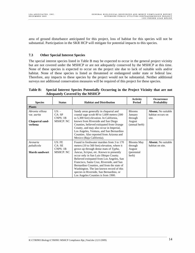
The special interest species listed in Table B may be expected to occur in the general project vicinity but are not covered under the MSHCP or are not adequately conserved by the MSHCP at this time. None of these species is expected to occur on the project site due to lack of suitable soils and/or habitat. None of these species is listed as threatened or endangered under state or federal law. Therefore, any impacts to these species by the project would not be substantial. Neither additional surveys nor additional conservation measures will be required of this project for these species. Table B: Special Interest Species Potentially Occurring in the Project Vicinity that are not
Adequately Covered by the MSHCP
Species Status Habitat and Distribution Activity Period
Occurrence Probability
Plants Abronia villosa var. aurita Chaparral sand-verbena
US: – CA: SP CNPS: 1B MSHCP: NC
Sandy areas generally in chaparral and coastal sage scrub 80 to 1,600 meters (300 to 5,300 feet) elevation. In California, known from Riverside and San Diego Counties, believed extirpated from Orange County, and may also occur in Imperial, Los Angeles, Ventura, and San Bernardino Counties. Also reported from Arizona and Mexico (Baja California).
Blooms January through August (annual herb)
Absent. No suitable habitat occurs on site.
Arenaria paludicola Marsh sandwort
US: FE CA: SE CNPS: 1B MSHCP: NC
Found in freshwater marshes from 3 to 170 meters (10 to 560 feet) elevation, where it grows up through dense mats of Typha, Juncus, Scirpus, etc. Known to presently occur only in San Luis Obispo County. Believed extirpated from Los Angeles, San Francisco, Santa Cruz, Riverside, and San Bernardino Counties, and from the state of Washington. The last known record of this species in Riverside, San Bernardino, or Los Angeles Counties is from 1900.
Blooms May through August (perennial herb)
Absent. No suitable habitat on site.

L S A A S S O C I A T E S , I N C . G E N E R A L B I O L O G I C A L R E S O U R C E S A N D M S H C P C O M P L I A N C E R E P O R T D E C E M B E R 2 0 0 9 R I V E R S I D E P U B L I C U T I L I T I E S S U B T R A N S M I S S I O N P R O J E C T 1 5 3 3 F E E D E R L O A D R E L I E F
R:\CTR0901\Biology\CTR0901 MSHCP Compliance Rpt_Final.doc (12/1/2009) 15
Table B: Special Interest Species Potentially Occurring in the Project Vicinity that are not Adequately Covered by the MSHCP
Species Status Habitat and Distribution Activity Period
Occurrence Probability
Calochortus plummerae Plummer’s mariposa lily
US: – CA: SP CNPS: 1B MSHCP: P
Sandy or rocky sites of (usually) granitic or alluvial material in valley and foothill grassland, coastal scrub, chaparral, cismontane woodland, and lower montane coniferous forest at 100 to 1,700 meters (300 to 5,600 feet) elevation. Known from the Santa Monica Mountains to San Jacinto Mountains in Riverside, San Bernardino, Orange, Los Angeles, and Ventura Counties. In the western Riverside County area, this species is known from the foothills of the San Bernardino Mountains, northeastern Santa Ana Mountains, Box Springs Mountains, and from the Lake Skinner area (The Vascular Plants of Western Riverside County, California. F. M. Roberts et al., 2004).
Blooms May through July (perennial herb)
Absent. Suitable habitat occurs on site but site is outside of species’ known range in western Riverside County.
Chorizanthe parryi var. parryi Parry’s spineflower
US: – CA: SP CNPS: 3 MSHCP: P
Dry sandy soils in chaparral or coastal scrub at 40 to 1,750 meters (100 to 5,700 feet) elevation. Known only from Riverside and San Bernardino Counties and possibly extending into Los Angeles County.
April through June (annual herb)
Absent. No suitable habitat on site.
Cordylanthus maritimus spp. maritmus Salt marsh bird’s beak
US: FE CA: SE CNPS: 1B MSHCP: NC
Coastal dunes and salt marshes below 30 meters (100 feet) elevation. In California, known from Los Angeles, Orange, Santa Barbara, San Diego, San Luis Obispo, and Ventura Counties. Historical collections referred to this taxon from alkaline meadow in vicinity of San Bernardino Valley are intermediate to C. maritimus ssp. canescens. Also occurs in Mexico.
Blooms May through October (annual herb)
Absent. No suitable habitat on site.
Dudleya multicaulis Many-stemmed dudleya
US: – CA: SP CNPS: 1B MSHCP: S
Heavy, often clay soils or around granitic outcrops in chaparral, coastal sage scrub, and grassland below 790 meters (2,600 feet) elevation. Known only from Los Angeles, Orange, Riverside, San Bernardino, and San Diego Counties.
Blooms April through July (perennial herb)
Absent. No suitable habitat on site.
Lepidium virginicum var. robinsonii Robinson’s pepper-grass
US: – CA: SP CNPS: 1B MSHCP: NC
Dry soils in coastal sage scrub and chaparral, typically below 500 meters (1,600 feet) elevation. In California, known only from Los Angeles, Orange, Riverside, Santa Barbara, San Bernardino, and San Diego Counties.
January through July
Absent. No suitable habitat on site.
Lycium parishii Parish’s desert-thorn
US: – CA: SP CNPS: 2 MSHCP: NC
Coastal scrub and Sonoran desert scrub at 300 to 1,000 meters (1,000 to 3,300 feet) elevation. In California, known from Imperial and San Diego Counties. Report from Riverside County is based on a misidentification. Known only historically from San Bernardino County (benches and/or foothills north of San Bernardino).
Blooms March through April (deciduous shrub)
Absent. No suitable habitat on site.

L S A A S S O C I A T E S , I N C . G E N E R A L B I O L O G I C A L R E S O U R C E S A N D M S H C P C O M P L I A N C E R E P O R T D E C E M B E R 2 0 0 9 R I V E R S I D E P U B L I C U T I L I T I E S S U B T R A N S M I S S I O N P R O J E C T 1 5 3 3 F E E D E R L O A D R E L I E F
R:\CTR0901\Biology\CTR0901 MSHCP Compliance Rpt_Final.doc (12/1/2009) 16
Table B: Special Interest Species Potentially Occurring in the Project Vicinity that are not Adequately Covered by the MSHCP
Species Status Habitat and Distribution Activity Period
Occurrence Probability
Symphyotrichum defoliatum (Aster defoliatus) San Bernardino aster
US: – CA: SP CNPS: 1B MSHCP: NC
Vernally wet sites (such as ditches, streams, and springs) in many plant communities below 2,040 meters (6,700 feet) elevation. In California, known from Ventura, Kern, San Bernardino, Los Angeles, Orange, Riverside, and San Diego Counties. In the western Riverside County area, this species is scarce, and documented only from Temescal and San Timoteo Canyons (The Vascular Plants of Western Riverside County, California. F.M. Roberts et al., 2004).
Blooms July through November (perennial herb)
Absent. Suitable habitat occurs on site but site is outside of species’ known range in western Riverside County.
Fish Rhinichthys osculus ssp. 3 Santa Ana speckled dace
US: – CA: CSC MSHCP: NC
Found in the headwaters of the Santa Ana and San Gabriel River drainages. Found in riffles in small streams and shore areas with abundant gravel and rock.
Year-round Absent. Project not located in headwaters of Santa Ana or San Gabriel Rivers.
Reptiles Charina trivirgata Rosy boa
US: – CA: SA MSHCP: NC
In rocky areas in chaparral or scrub habitats or immediately adjacent oak woodland; also in rocky riparian areas. Found in Los Angeles County, southwestern San Bernardino County, south through western Riverside County, and San Diego County into Baja California.
Nocturnal. Rarely active during day. Active between April and September
Absent. Riparian areas on site are not suitably rocky. No other suitable habitat occurs on site.
Mammals Eumops perotis Western mastiff bat
US: – CA: CSC MSHCP: NC
Occurs in many open, semi-arid to arid habitats, including conifer and deciduous woodlands, coastal scrub, grasslands, chaparral, etc.; roosts in crevices in vertical cliff faces, high buildings, and tunnels, and travels widely when foraging.
Primarily the warmer months
Low. No suitable roosting habitat occurs on site. May use site for foraging.
Lasiurus xanthinus Western yellow bat
US: – CA: SA MSHCP: NC
Occurs in southern California in palm oases and in residential areas with untrimmed palm trees. Roosts primarily in trees, especially the dead fronds of palm trees. Forages over water and among trees.
Primarily the warmer months
Low. No palm oases on site, but may roost in fan palms located in riparian habitat on site.
Onychomys torridus ramona Southern grasshopper mouse
US: – CA: CSC MSHCP: NC
Arid habitats, especially scrub habitats with friable soils. Coastal scrub, mixed chaparral, sagebrush, low sage, bitterbrush, and grassland habitats. Arid portions of southwestern California and northwestern Baja California.
Nocturnal, active year-round
Moderate. Suitable arid grassland habitat occurs on site.

L S A A S S O C I A T E S , I N C . G E N E R A L B I O L O G I C A L R E S O U R C E S A N D M S H C P C O M P L I A N C E R E P O R T D E C E M B E R 2 0 0 9 R I V E R S I D E P U B L I C U T I L I T I E S S U B T R A N S M I S S I O N P R O J E C T 1 5 3 3 F E E D E R L O A D R E L I E F
R:\CTR0901\Biology\CTR0901 MSHCP Compliance Rpt_Final.doc (12/1/2009) 17
Legend US: Federal Classifications – FE
No applicable classification Taxa listed as Endangered.
CA: State Classifications CSC California Species of Special Concern. Refers to animals with vulnerable or seriously declining populations. SA Special Animal. Refers to any other animal monitored by the Natural Diversity Data Base, regardless of its legal or
protection status. SE Taxa State-listed as Endangered. SP Special Plant. Refers to any other plant monitored by the Natural Diversity Data Base, regardless of its legal or
protection status. CNPS: California Native Plant Society Classifications 1B Plants considered by CNPS to be rare, threatened, or endangered in California and elsewhere. 2 Plants considered by CNPS to be rare, threatened, or endangered in California, but more common elsewhere. 3 Plants suggested by CNPS for consideration as endangered but about which more information is needed. MSHCP: Western Riverside County MSHCP Status NC Species not is covered under the MSHCP. P Species is covered but not considered adequately conserved pending completion of MSHCP specified requirements. S Species is adequately conserved under the MSHCP, but surveys are required within indicated habitats and/or survey
areas. 7.4 Wildlife Movement, Corridors, and Nursery Sites Wildlife movement includes seasonal migration along corridors, as well as daily movements for foraging and reaching water sources. Migrational corridors may include areas of unobstructed movement for deer, riparian corridors providing cover for migrating birds, routes between breeding waters and upland habitat for amphibians, and between roosting and feeding areas for birds. The project site is not adjacent to any existing or proposed linkage or core areas as identified in the MSHCP. The site is surrounded by residential uses on the south,? east and west. The riparian area within the western portion of the site could provide wildlife movement habitat for many species. As part of the project, an electric transmission cable will be permanently installed over this wildlife corridor. This cable may result in minor impedance to wildlife movement along this corridor; however, since the cable will be small and will not completely obstruct the corridor, impacts will not be substantial. No other structures are proposed within the wildlife corridor; therefore, no substantial impacts are expected. Participation in the MSHCP will mitigate for minor project impacts to wildlife movement. There are no nursery sites, such as bat roosting sites or bird rookeries, on the project site. 7.5 Natural Communities of Interest Riparian habitats, oak woodlands, wetlands, aquatic sites, and vernal pools are among the natural communities of interest to the CDFG. The project site contains riparian habitat in both the eastern and western portions (Figure 2). The project has been designed to avoid permanent impacts to riparian habitat, and no permanent loss of riparian habitat will occur as a result of project implementation.
L S A A S S O C I A T E S , I N C . G E N E R A L B I O L O G I C A L R E S O U R C E S A N D M S H C P C O M P L I A N C E R E P O R T D E C E M B E R 2 0 0 9 R I V E R S I D E P U B L I C U T I L I T I E S S U B T R A N S M I S S I O N P R O J E C T 1 5 3 3 F E E D E R L O A D R E L I E F
R:\CTR0901\Biology\CTR0901 MSHCP Compliance Rpt_Final.doc (12/1/2009) 18
Temporary impacts to riparian habitat may occur while stringing cable over the riparian areas. In order to reduce temporary impacts to riparian habitat, best management practices (BMPs) as identified in Volume One, Appendix C of the MSHCP will be implemented. 7.6 Wetlands and Other Jurisdictional Areas The study area contains potential wetland and non-wetland waters of the U.S. Due to the presence of an ordinary high water mark, streambed, and riparian vegetation, it is likely that the two washes in the eastern portion of the study area and the large wash in the western portion of the study area are subject to the jurisdiction of ACOE, CDFG, and RWQCB. The project has been designed to avoid permanent impacts to wetland and non-wetland waters of the U.S. and associated riparian habitat. Implementation of BMPs as identified in the MSHCP will ensure no impacts to wetland and non-wetland waters of the U.S. and associated riparian habitat will occur; therefore, no authorization from ACOE, CDFG or RWQCB will be required. If the proposed project changes and it is determined that the project will result in fill, grading, or excavation of waters of the U.S., or removal of wetland or riparian vegetation, authorization from ACOE, CDFG and RWQCB will be required. 7.7 Local Policies and Ordinances Protecting Biological Resources City and County General Plans and development ordinances may include regulations or policies governing biological resources. For example, policies may include tree preservation, locally designated species survey areas, local species of interest, and significant ecological areas. There are no other local ordinances applicable to biological resources except for code provisions related to the MSHCP mitigation fee and land credits. The project will not be in conflict with any local policies or ordinances applicable to biological resources. 7.8 Indirect Effects Indirect impacts to surrounding areas as a result of the project may include, but are not limited to, increased dust, noise, lighting, and traffic. Since the project is not adjacent to any areas identified as MSHCP Linkages or Core Areas, indirect impacts to surrounding conservation are not anticipated. Project activities adjacent to riparian areas should implement BMPs as described in Volume One, Appendix C of the MSHCP. 7.9 Cumulative Effects Cumulative impacts refer to incremental effects of an individual project when viewed in connection with the effects of past projects, current projects, and probable future projects. Project construction will contribute to the incremental loss of natural habitat in the region. Cumulative impacts potentially include limitations on wildlife movement, increased edge effects, reduced habitat quality, and increased wildlife mortality. The MSHCP provides a comprehensive approach to the regional conservation of natural habitats and, as a regional plan, serves to provide mitigation for cumulative impacts to covered species. Project compliance and consistency with the

L S A A S S O C I A T E S , I N C . G E N E R A L B I O L O G I C A L R E S O U R C E S A N D M S H C P C O M P L I A N C E R E P O R T D E C E M B E R 2 0 0 9 R I V E R S I D E P U B L I C U T I L I T I E S S U B T R A N S M I S S I O N P R O J E C T 1 5 3 3 F E E D E R L O A D R E L I E F
R:\CTR0901\Biology\CTR0901 MSHCP Compliance Rpt_Final.doc (12/1/2009) 19
MSHCP ensure that any cumulative impacts to covered species are effectively mitigated. Special interest species that are not covered by the MSHCP also benefit from the surveys, conservation, and other measures of the MSHCP because they occupy many of the same habitats. 8.0 RECOMMENDATIONS • Focused burrowing owl surveys are required due to the presence of suitable burrowing owl
habitat in an MSHCP-designated burrowing owl survey area. Surveys consist of four site visits and should be conducted by a qualified biologist between March 1 and August 31.
• Pre-construction burrowing owl surveys will be required within 30 days prior to any phase of construction in the areas identified as potential burrowing owl habitat. These pre-construction surveys are also required in order to comply with the MSHCP, Migratory Bird Treaty Act (MBTA), and the California Fish and Game Code. If any of the pre-construction surveys determine that burrowing owl are present, mitigation measures may be required.
• In order to avoid impacts to nesting birds, no native or exotic vegetation removal or tree trimming activities will occur during the nesting bird season (February 15–August 31). In the event that vegetation clearing is necessary during the nesting season, a qualified biologist will conduct a pre-construction survey to identify the locations of nests. Should nesting birds be found, an exclusionary buffer will be established by the biologist. This buffer shall be clearly marked in the field by construction personnel under guidance of the biologist, and construction or clearing will not be conducted within this zone until the biologist determines that the young have fledged or the nest is no longer active. If project activities are scheduled within riparian habitat during the nesting bird season, focused riparian bird surveys will be required in order to avoid take of least Bell’s vireo and southwestern willow flycatcher.
• The following measures will be incorporated to avoid potential impacts to riparian/riverine habitat and associated riparian species, such as least Bell’s vireo and southwestern willow flycatcher:
o During construction, soil and vegetation disturbance will be minimized to the greatest extent feasible. Prior to clearing or construction, highly visible barriers (such as orange construction fencing) will be installed around riparian/riverine vegetation, under the guidance of a qualified biologist. These areas will be designated as Environmentally Sensitive Areas (ESAs) to be preserved. No grading or fill activity of any type will be permitted within the ESA. In addition, heavy equipment, including motor vehicles, will not be allowed to operate within the ESAs. All construction equipment shall be operated in a manner so as to prevent accidental damage to nearby preserved areas. No structure of any kind, or incidental storage of equipment or supplies, shall be allowed within the ESA. Silt fence barriers will be installed at the ESA boundary to prevent accidental deposition of fill material in areas where vegetation is immediately adjacent to planned grading activities.
o A biologist will monitor construction within the vicinity of designated ESA areas for the duration of the project to flush any wildlife species present prior to construction and to ensure that all vegetation removal, BMPs, ESAs, and all avoidance and minimization measures are properly constructed and followed.
o Applicable Best Management Practices (BMPs_ as identified in MSHCP Appendix C will be implemented during project construction in order to minimize siltation and erosion and point

L S A A S S O C I A T E S , I N C . G E N E R A L B I O L O G I C A L R E S O U R C E S A N D M S H C P C O M P L I A N C E R E P O R T D E C E M B E R 2 0 0 9 R I V E R S I D E P U B L I C U T I L I T I E S S U B T R A N S M I S S I O N P R O J E C T 1 5 3 3 F E E D E R L O A D R E L I E F
R:\CTR0901\Biology\CTR0901 MSHCP Compliance Rpt_Final.doc (12/1/2009) 20
and/or nonpoint pollution sources in established ESAs during and following the project’s construction phase.
o Equipment maintenance and staging will occur in designated areas, away from ESAs. If work must be done at night, noise and direct lighting would be directed away from ESAs.
o During construction, the construction contractor shall inspect and clean construction equipment at the beginning and end of each day for fluid leaks.
o ESAs will be kept clear of all equipment or structures that could potentially serve as barriers to wildlife passage.

L S A A S S O C I A T E S , I N C . G E N E R A L B I O L O G I C A L R E S O U R C E S A N D M S H C P C O M P L I A N C E R E P O R T D E C E M B E R 2 0 0 9 R I V E R S I D E P U B L I C U T I L I T I E S S U B T R A N S M I S S I O N P R O J E C T 1 5 3 3 F E E D E R L O A D R E L I E F
R:\CTR0901\Biology\CTR0901 MSHCP Compliance Rpt_Final.doc (12/1/2009) 21
9.0 REFERENCES AirPhotoUSA. 2007. Riverside County, California, January–March 2006 flights. Digital Globe, Inc.
Phoenix, Arizona. AirPhotoUSA. 2006. Riverside County, California, January–March 2006 flights. Digital Globe, Inc.
Phoenix, Arizona. Burrowing Owl Consortium, The. 1993. Burrowing Owl Survey Protocol and Mitigation Guidelines.
April 1993; revised August 23, 2000. California Department of Fish and Game. 2003. List of California Terrestrial Natural Communities
Recognized by the Natural Diversity Data Base. September. California Department of Fish and Game, Natural Diversity Data Base. 2009. Rarefind 3 version
3.1.0. The Resources Agency, Sacramento, California. California Native Plant Society. 2009. Inventory of Rare and Endangered Plants online edition, v. 7-
07c. California Native Plant Society. Sacramento, California. http://www.cnps.org/inventory. California, State of. 2007. California Fish and Game Code. Office of Legislative Counsel online
legislation database access. http://www.leginfo.ca.gov/. Consulting Engineers and Land Surveyors of California. 2007. California Environmental Quality Act:
CEQA Guidelines. Sacramento, California. Knecht, A.A. 1971. Soil Survey of Western Riverside Area, California. U.S. Department of
Agriculture, Washington D.C. National Weather Service Forecast Office. San Diego Regional Center. http://newweb.wrh.noaa.gov/
sgx/obs/rtp/rtpmap.php?wfo=sgx. Accessed on August 29, 2007. Natural Resources Conservation Service. 2003. Riverside County, California. Soil Data Mart
SSURGO metadata and GIS maps. http://soildatamart.nrcs.usda.gov/. Rand McNally and Company. 2005. ArcInfo coverage of road data from Thomas Guide for Riverside
County, California. Chicago, Illinois. Riverside, County of. 2005. Metadata for Western Riverside County Multiple Species Habitat
Conservation Plan provided by County GIS Department. Riverside, California. Riverside County Planning Department. 2006. Riverside County Oak Tree Management Guidelines.
http://www.tlma.co.riverside.ca.us/planning/content/devproc/guidelines/oak_trees/oak_trees.html.
Riverside County Transportation and Land Management Agency. 2003. Western Riverside County
Multiple Species Habitat Conservation Plan (MSHCP). Final MSHCP—Volumes 1 and 2. Approved June 17, 2003.
L S A A S S O C I A T E S , I N C . G E N E R A L B I O L O G I C A L R E S O U R C E S A N D M S H C P C O M P L I A N C E R E P O R T D E C E M B E R 2 0 0 9 R I V E R S I D E P U B L I C U T I L I T I E S S U B T R A N S M I S S I O N P R O J E C T 1 5 3 3 F E E D E R L O A D R E L I E F
R:\CTR0901\Biology\CTR0901 MSHCP Compliance Rpt_Final.doc (12/1/2009) 22
Sawyer and Keeler-Wolf. 1995. A Manual of California Vegetation. California Native Plant Society,
Sacramento, California. Soil Conservation Service. 1971. Soil Survey of Riverside County, California. United States
Department of Agriculture, Washington, D.C. United States Army Corps of Engineers. 2007. Memorandum Re: Clean Water Act Jurisdiction
following the U.S. Supreme Court’s Decision in Rapanos v. United States & Carabell v. United States. June 5, 2007.
United States Army Corps of Engineers and Environmental Protection Agency. 2007. U.S. Army
Corps of Engineers Jurisdictional Determination Form Instructional Guidebook. May 30, 2007.
United States Fish and Wildlife Service. 2000. Endangered and Threatened Wildlife and Plants: Final
Determination of Critical Habitat for the Coastal California gnatcatcher; Final Rule. 50 CFR Part 17. Tuesday, October 24, 2000. pp. 63680 through 63743.
United States Fish and Wildlife Service. 2002. Migratory Bird Treaty Act. A Guide to the Laws and
Treaties of the United States for Protecting Migratory Birds. Last Revised: 05/21/2002. http://www.fws.gov/migratorybirds/intrnltr/treatlaw.html#mbta.
United States Fish and Wildlife Service. 2003. Endangered and Threatened Wildlife and Plants: Final
Determination of Critical Habitat for the Coastal California gnatcatcher; Proposed Rule. 50 CFR Part 17. Thursday, April 24, 2003. pp. 20228 through 20312.
United States Geological Survey. 7.5-minute Riverside East, California; Riverside West, California;
Steel Peak, California; and Lake Mathews, California quadrangles. University of California Integrated Pest Management Online. 2007. California Weather Data.
University of California. Agriculture and Natural Resources. http://www.ipm.ucdavis.edu/WEATHER/SITES/riverside.html. Accessed on August 29, 2007.
Western Regional Climate Center. 2007. Western Regional Climate Center: Western U.S. Climate
Historical Summaries. http://www.wrcc.dri.edu/Climsum.html (accessed August 15, 2007).

R:\CTR0901\Biology\CTR0901 MSHCP Compliance Rpt_Draft.doc (12/1/2009)
APPENDIX A
PLANT AND ANIMAL SPECIES OBSERVED
R:\CTR0901\Biology\CTR0901 MSHCP Compliance Rpt_Draft.doc (12/1/2009) A-1
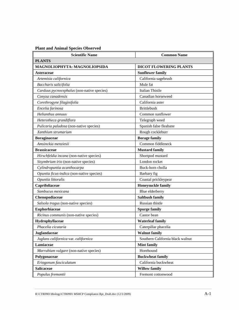
Plant and Animal Species Observed Scientific Name Common Name
PLANTS MAGNOLIOPHYTA: MAGNOLIOPSIDA DICOT FLOWERING PLANTS Asteraceae Sunflower family Artemisia californica California sagebrush Baccharis salicifolia Mule fat Carduus pycnocephalus (non-native species) Italian Thistle Conyza canadensis Canadian horseweed Corethrogyne filaginifolia California aster Encelia farinosa Brittlebush Helianthus annuus Common sunflower Heterotheca grandiflora Telegraph weed Pulicaria paludosa (non-native species) Spanish false fleabane Xanthium strumarium Rough cockleburr Boraginaceae Borage family Amsinckia menziesii Common fiddleneck Brassicaceae Mustard family Hirschfeldia incana (non-native species) Shortpod mustard Sisymbrium irio (non-native species) London rocket Cylindropuntia acanthocarpa Buck-horn cholla Opuntia ficus-indica (non-native species) Barbary fig Opuntia littoralis Coastal prickleypear Caprifoliaceae Honeysuckle family Sambucus mexicana Blue elderberry Chenopodiaceae Saltbush family Salsola tragus (non-native species) Russian thistle Euphorbiaceae Spurge family Ricinus communis (non-native species) Castor bean Hydrophyllaceae Waterleaf family Phacelia cicutaria Caterpillar phacelia Juglandaceae Walnut family Juglans californica var. californica Southern California black walnut Lamiaceae Mint family Marrubium vulgare (non-native species) Horehound Polygonaceae Buckwheat family Eriogonum fasciculatum California buckwheat Salicaceae Willow family Populus fremontii Fremont cottonwood

R:\CTR0901\Biology\CTR0901 MSHCP Compliance Rpt_Draft.doc (12/1/2009) A-2
Plant and Animal Species Observed Scientific Name Common Name
Salix exigua Narrowleaf willow Salix gooddingii Goodding’s willow Salix lasiolepis Arroyo willow Solanaceae Nightshade family Datura wrightii Sacred thorn-apple Nicotiana glauca (non-native species) Tree tobacco Tamaricaceae Tamarisk family Tamarix sp. (non-native species) Tamarisk Urticaceae Nettle Family Urtica dioica Stinging nettle MAGNOLIOPHYTA: LILIOPSIDA MONOCOT FLOWERING PLANTS Arecaceae Palm family Washingtonia filifera California fan palm Poaceae Grass family Arundo donax (non-native species) Giant reed Bromus diandrus (non-native species) Ripgut brome Bromus madritensis ssp. rubens (non-native species) Red brome Hordeum murinum (non-native species) Foxtail barley Schismus barbatus (non-native species) Common Mediterranean grass Typhaceae Cattail family Typha sp. Cattail ANIMALS REPTILIA REPTILES Phrynosomatidae Phrynosomatid Lizards Sceloporus occidentalis Western fence lizard Uta stansburiana Common side-blotched lizard AVES BIRDS Columbidae Pigeons and Doves Zenaida macroura Mourning dove Trochilidae Hummingbirds Calypte anna Anna’s hummingbird Picidae Woodpeckers Picoides nuttallii Nuttall’s woodpecker Tyrannidae Tyrant Flycatchers Sayornis nigricans Black phoebe Corvidae Crows and Ravens Corvus brachyrhynchos American crow

R:\CTR0901\Biology\CTR0901 MSHCP Compliance Rpt_Draft.doc (12/1/2009) A-3
Plant and Animal Species Observed Scientific Name Common Name
Aegithalidae Bushtits Psaltriparus minimus Bushtit Mimidae Mockingbirds and Thrashers Mimus polyglottos Northern mockingbird Parulidae Wood Warblers Dendroica coronata Yellow-rumped warbler Emberizidae Emberizines Pipilo crissalis California towhee Melospiza melodia Song sparrow Cardinalidae Cardinals, Grosbeaks and Allies Pheucticus melanocephalus Black-headed grosbeak Fringillidae Finches Carpodacus mexicanus House finch MAMMALIA MAMMALS Leporidae Rabbits and Hares Sylvilagus audubonii Desert cottontail Canidae Foxes, Wolves and Dogs Canis latrans Coyote
![Neurophysiological differences between patients clinically ... · approach, as opposed to a first-contact sampling approach, ... medication compliance [4] and may also have biological](https://static.fdocuments.us/doc/165x107/6042a19ce2f4537e59590d3b/neurophysiological-differences-between-patients-clinically-approach-as-opposed.jpg)


