GE DI E I A DI A D AC I LA - Northumberland Coast Area of ... · 4 Northumberland Coast Area of...
37
Northumberland Coast Area of Outstanding Natural Beauty and European Marine Site GEODIVERSITY AUDIT AND ACTION PLAN
Transcript of GE DI E I A DI A D AC I LA - Northumberland Coast Area of ... · 4 Northumberland Coast Area of...

Northumberland Coast Area of Outstanding Natural Beauty and European Marine Site
GEODIVERSITY AUDIT AND ACTION PLAN

3Geodiversity Audit and Action Plan2 Northumberland Coast Area of Outstanding Natural Beauty and European Marine Site
AONB/EMS Map ...................................................................................................... 2
Summary .................................................................................................................. 4
Introduction .............................................................................................................. 5
AONBs
European Marine Sites
Purpose of the Plan
Geodiversity - what is it and why does it matter?
Designated sites
Geological time
The geological story of the coast .............................................................................. 8
The geodiversity of the coast .................................................................................... 11
Geological maps of the coast .................................................................................. 12
Carboniferous rocks .............................................................................................. 16
Permian rocks ...................................................................................................... 26
Intrusive igneous rocks – the Whin Sill Swarm ...................................................... 27
Metamorphic rocks ................................................................................................ 34
Quaternary deposits .............................................................................................. 36
Geological structures ............................................................................................ 43
Fossils .................................................................................................................. 46
Minerals ................................................................................................................ 48
Mineral extraction .................................................................................................. 50
Building stones and the built environment ............................................................ 54
Action Plan .............................................................................................................. 56
Selected references and maps ................................................................................ 63
Glossary .................................................................................................................. 67
CONTENTS
The Northumberland Coast at Longhoughton Steel

5Geodiversity Audit and Action Plan4 Northumberland Coast Area of Outstanding Natural Beauty and European Marine Site
Intro
du
ctio
nG
eo
log
y o
f the
Co
ast
Ge
od
ive
rsity
Au
dit
Actio
n P
lan
Re
fere
nce
Areas of Outstanding Natural Beauty (AONBs)
AONBs were created by the National Parks and Access to the Countryside Act (1949) and
since 1956 forty AONBs have been designated in England and Wales. The UK’s AONBs
and National Parks are within a worldwide category of protected areas known as
International Union for the Conservation of Nature (IUCN) CatgeoryV Protected
Landscapes, designated so that their qualities can be enjoyed by present and future
generations. AONBs range in size from the Isles of Scilly (16km2) to the Cotswolds
(2038km2). The other Protected Landscapes in the North East region are the North
Pennines AONB and Northumberland National Park. AONBs and National Parks have the
same protection in the landuse planning system.
The Northumberland Coast AONB was designated in 1958 and covers an area of 138km2
along 64km of coastline from Berwick to the Coquet estuary. Though nowhere more than
2.5km wide, this area is remarkably rich in natural and cultural heritage.
European Marine Sites (EMS)
In 1994 the UK Government incorporated into law as the Conservation (Natural Habitats, &c.)
Regulations 1994, the EU Habitats Directive and the Birds Directive. This is commonly
known as the Habitats Regulations. A European Marine Site is any area designated under
the Habitats Regulations as Special Protection Area of Special Area of Conservation that
includes a marine area.
The EMS covers 115km of coastline over 635km2 of shore and sea, from Fast Castle
Head to Alnmouth and includes the Farne Islands and Lindisfarne.
The Northumberland Coast AONB/EMS has long, sweeping beaches, rocky cliffs and
isolated islands. The bird and marine life of the coast is internationally important. It also
has a 7,000 year history of human activity and its castles, fishing villages and Christian
heritage all contribute to its special character.
More detail on the purpose of designation and the special qualities of the AONB can be
found in the AONB/EMS joint management plan.
The AONB/EMS Management Plan
Through the AONB/EMS Management Plan, policies for the better conservation,
enhancement and understanding of wildlife, cultural and historical assets are already in
place. Included in the management plan is an objective to produce and implement the
findings of a geodiversity audit and action plan. The production of this document and the
implementation of its action plan may be seen as a fundamental objective of the AONB
and EMS Partnerships over the next five years.
The Purpose of this Geodiversity Audit and Action Plan
The principal aim of this plan is to guide the conservation and interpretation of the
geological features of the Northumberland Coast. It is also intended to support the
development of sustainable nature-based tourism in the area.
The main objectives of this Geodiversity Audit and Action Plan can be summarised as:
• to improve knowledge and understanding of the geodiversity resources on the
Coast;
• to identify the main geological formations and features and to evaluate their
contribution to local geodiversity;
• to identify linkages between the area’s geodiversity and its landscape character,
biodiversity, economic and cultural history;
• to identify threats to geological features and opportunities for their conservation and
enhancement; and
• to identify a network of individual sites which encapsulate the essential features of
the area’s geology and where possible identify how these might be used to support
interpretation and education programmes and projects.
Recommendations and action points for any aspect of geodiversity can only be meaningful
and credible if they are devised in the light of a sound, modern understanding of the area’s
Earth heritage. In this plan the key elements of the area’s geology are outlined in sufficient
detail to inform and underpin specific recommendations and action points.
The principal audience for this document is not practising geologists, but those who
manage and influence the Northumberland Coast AONB and EMS. Readers of this
document who may have little geological knowledge, or be unfamiliar with the geology of
the area, should be able to appreciate the geology of the Coast, why it is important and
how it might be conserved, interpreted and used to support educational programmes.
INTRODUCTION
This Geodiversity Audit and Action Plan focuses on the Northumberland Coast Area of
Outstanding Natural Beauty (AONB) and European Marine Site (EMS). It is a companion
document to the AONB/EMS Joint Management Plan.
The area covered by this plan is shown on the map on the inside front cover of this
document.
This document comprises an Audit and an Action Plan:
The Audit summarises the geological and geomorphological heritage of the area and
identifies:
• the different rock types;
• the importance of the rock types or particular sites in terms of biodiversity and their
impact on the landscape;
• the uses of the rocks; and
• any wider significance of each rock type.
The Action Plan is arranged under the headings:
• Understanding more about our geodiversity (addressing the need for continued
research and study);
• Conserving our geodiversity (addressing designations and site-based conservation
work);
• Interpreting our geodiversity (addressing how people might be guided towards
greater enjoyment and understanding of the coast’s geological heritage); and
• Education and lifelong learning about our geodiversity (addressing how programmes
of formal and information education might be developed).
It is the intention that interpretation and education projects may be integrated with other
subjects and themes along the coast.
Accompanying this document is a GIS-based digital dataset containing all of the sites and
features referred to in this plan, accompanied by spatial information, basic descriptions
and further references.
SUmmARY
Howick Bay, excavated in Carboniferous sandstones, limestones and shales

7Geodiversity Audit and Action Plan
Intro
du
ctio
nG
eo
log
y o
f the
Co
ast
Ge
od
ive
rsity
Au
dit
Actio
n P
lan
Re
fere
nce
Intr
od
uctio
nG
eo
log
y o
f th
e C
oa
st
Ge
od
ive
rsity A
ud
itA
ctio
n P
lan
Re
fere
nce
6 Northumberland Coast Area of Outstanding Natural Beauty and European Marine Site
Geodiversity – what is it and why does it matter?
Recent years have seen many different definitions of Geodiversity put forward, but it is
succinctly captured in Mick Stanley’s 2001 definition: ‘The variety of geological
environments, phenomena and processes that make those landscapes, rocks, minerals,
fossils and soils which provide the framework for life on Earth’. Geodiversity makes the
links between people, landscape, biodiversity and culture and is one of an area’s chief
natural resources. It has a profound influence on the landscape, habitats and species and
also on the economic activities and history of settlement in any given place.
Following the UK government’s ratification of the UN Convention on Biological Diversity,
which resulted from the Rio Earth Summit in 1992, and the production in 1995 of the UK
Biodiversity Steering Group’s Report “Meeting the Rio Challenge”, the concept of
‘biodiversity’ is now widely understood. Subsequent years saw the preparation and
implementation of Biodiversity Action Plans for most parts of the UK, including
Northumberland. Biodiversity is now accepted as an essential element in sustainable
planning and management strategies. Until recently the parallel concept of geodiversity
has attracted little interest, despite its fundamental importance in underpinning
biodiversity. However, the last five years in particular have seen a growing interest in the
concept of geodiversity and in the production of geodiversity audits and action plans. The
North East of England, (notably the North Pennines AONB Partnership through the
production of the area’s first GAP and establishment of the European Geopark, and
Natural England which has helped to champion geodiversity policies in strategic
documents), has been at the forefront of embracing geodiversity and making it part of
mainstream conservation thinking and practice.
It is a common misconception that geological and landscape features, other than those
already afforded some measure of protection as Sites of Special Scientific Interest
(SSSIs), are sufficiently robust not to require active management or action planning, but all
geological features are potentially vulnerable. In addition to obvious threats posed by
inappropriate site development and the infilling of quarries, the encroachment of
vegetation, natural weathering and general deterioration with time may threaten to
damage or obliterate important geological features. This situation would not be tolerated in
wildlife or archaeological sites of comparable scientific or educational value.
Geology is fundamental to almost every aspect of life. Geological resources provide the
raw materials for civilisation, be they fuels, water supply, metal ores or bulk and industrial
minerals and building materials. A clear understanding of geology is vital to the design and
siting of buildings, roads, railways and airports as well as to the safe control of waste
disposal and the management of a wide range of natural and man-made natural hazards.
The importance of the range and diversity of Earth science features – the ‘geodiversity’ –
of any area is as important a facet of its natural heritage as its wildlife interests.
Conservation, sustainable management, educational use and interpretation of geodiversity
is thus as important as that of biodiversity, archaeology etc. Knowledge of an area’s
geology undoubtedly makes it much easier to understand the character of the local
landscape, and also makes it easier to understand an area’s biodiversity. Geodiversity
literally and figuratively underpins all aspects of heritage.
Designated Sites and Features
International, European and National Designations
The varied landscape of the Northumberland Coast includes a wealth of sites and features
which, for a variety of reasons, are subject to conservation designations of various kinds.
These include international designation (RAMSAR sites), areas of Europe-wide
conservation importance (Special Protection Areas (SPA) and Special Areas of
Conservation (SAC)), and national designations (National Nature Reserves (NNRs) and
Sites of Special Scientific Interest (SSSI)).
Geological Conservation Review Sites
The Geological Conservation Review (GCR) was initiated by the Nature Conservancy
Council in 1977 to identify, assess, document and eventually publish, accounts of the most
important parts of Great Britain’s geological heritage. GCR sites are those of national or
international importance which have either been notified as SSSIs or are being considered
for such notification. Publication of descriptions of GCR sites is being undertaken in a
series of 42 thematic volumes. Since 1991, publication of descriptions of GCR sites has
been undertaken by the Joint Nature Conservation Committee on behalf of the three
country agencies, Natural England, Scottish Natural Heritage, and the Countryside
Council for Wales.
Local Sites
Other localities have non-statutory designation, for example, as County Wildlife Sites or
the Voluntary Marine Nature Reserve at St Abbs Head. There is no active Regionally
Important Geological and Geomorphological Sites (RIGS) network in Northumberland and
no sites are currently recorded under this second tier designation, which has the same
status as the County Wildlife Sites (Local Sites). A review of Local Sites and the criteria for
their designation was being proposed at the time of writing this document.
A complete database of designations, sites, area, their principal interest feature and their
geological interest has been complied for this Geodiversity Audit and Action Plan and is
available on the AONB/EMS Partnerships’ websites.
Geological Time
The rocks of the Northumberland coast provide us with a tangible record of long past
events and Earth processes that created, shaped, and continue to shape, the landscape
we see today. The events recorded by these rocks date back over many millions of years.
In order to appreciate, and place these rocks in their true context, it is useful to look very
briefly at geological time.
The earth is currently known to be almost 4600 million years old. As such an immense
span of time is virtually impossible to imagine, it is helpful to represent the whole of Earth
history by a single day (see diagram)*. On this basis, the oldest rocks present within the
AONB/EMS, which date back to about 350 million years ago, were formed at around
10.30pm; the Quaternary ice ages started at about one minute to midnight and the whole
of human history took place within the last two seconds to midnight!
For convenience of description and interpretation, geologists, like historians, divide time
into manageable units to which they give names. Geological time is divided into Periods,
as shown in the diagram.
Geological time diagram
Reproduced with permission of Durham County Council

9Geodiversity Audit and Action Plan
Intro
du
ctio
nG
eo
log
y o
f the
Co
ast
Ge
od
ive
rsity
Au
dit
Actio
n P
lan
Re
fere
nce
Intr
od
uctio
nG
eo
log
y o
f th
e C
oa
st
Ge
od
ive
rsity A
ud
itA
ctio
n P
lan
Re
fere
nce
8 Northumberland Coast Area of Outstanding Natural Beauty and European Marine Site
The outer layer of the Earth, the part with which we are familiar, consists of a series of
huge comparatively thin slabs of rock up to around 100km thick, known as plates, which
effectively float above deeper partially molten rock. These plates, on which occur the
Earth’s continents and oceans, are in constant motion, in places pulling apart, in places
colliding with one another. Although imperceptible to us, on a geological timescale this
motion is surprisingly rapid in places, estimated to be roughly the speed at which human
finger nails grow.
The nature and distribution of the rocks we see today in Northumberland result from the
movement of these continental plates over many millions of years of geological time.
The oldest rocks that crop out at the surface in the AONB are of Carboniferous age and
are the product of geological processes that affected what is now northern England
between about 350 and 290million years ago. However, by studying adjoining areas, we
know that these Carboniferous rocks rest upon much older rocks that are exposed at the
surface today in the Cheviot Hills, the Scottish Borders and along the Berwickshire coast.
These now concealed older rocks give us important clues to events that were then
shaping the region and which were to influence the succession of rocks which occur today
at the surface in the AONB.
To best comprehend the development of this part of Northumberland we must venture
back almost 500million years to the Ordovician Period of Earth history.
At that time the map of the Earth was very different from today. The portion of the Earth’s
crust that was destined to become Northumberland lay far south of the Equator, beneath
the waters of a deep ocean, known to geologists as the Iapetus Ocean, between two huge
continents. The northern continent, known as Laurentia contained what would eventually
become Scotland, North America and Greenland. The southern continent, known as
Avalonia, which lay close to the much larger continental mass of Gondwana, included
what subsequently became England, Wales and southern Ireland. By the process of plate
tectonics, these two continents moved inextricably closer to one another. As they did so
the sediments deposited in the deep ocean were progressively squeezed and began to be
pushed downwards into the Earth, a process known as subduction. As a result, volcanoes
developed in the area we see today as Wales, the Lake District and parts of southern
Scotland. By about 420million years ago, during the Silurian Period, the continents finally
collided, resulting in severe crumpling of the oceanic sediments, and the creation of a
huge chain of mountains including the Scottish Highlands and Southern Uplands. The
hard grey sandstones and shales of the Southern Uplands and the Berwickshire coast,
some of which show spectacular folds due to these severe Earth movements, are the
remnants of these oceanic sediments. The original physical union of Scotland and
England thus dates back to these vast Earth movements over 400million years ago.
The line of continental collision, known as the Iapetus Suture, today lies buried deep
between the Solway coast and Berwick-upon-Tweed. Although this line has no obvious
surface expression today, its presence was to have a fundamental influence on the
region’s geological history, the rocks that formed there and ultimately the landscape we
see today.
At the time of the collision, our area lay a little south of the Equator and formed part of a
large continent. The climate was hot and arid and volcanoes were still actively erupting in
what is now the Cheviots. Rapid erosion quickly degraded the mountains and piled up
huge thicknesses of red sands and gravels which we see today as the Old Red Sandstone
of the Scottish Borders and Berwickshire coast.
By about 350million years ago, at the beginning of the Carboniferous Period, our area lay
on or very close to the Equator. Stretching of the Earth’s crust, along lines roughly parallel
to the Iapetus Suture, resulted in the development of a series of fault-bounded basins
heralding a period of around 50million years during which our area would lie very close to,
and on many occasions a little below, sea level. The largest of these, the
Northumberland–Solway Trough, was to be the locus of much of the sediment preserved
today as the Carboniferous rocks of the AONB.
Early in Carboniferous times, whilst the climate remained arid, thick accumulations of
gravels, washed from the ancestors of the Cheviot Hills, and seen today as conglomerate
at places such as Roddam Dene, near Wooler, were soon submerged beneath sands, silts
and muds washed into the basin by rivers draining from the north, whilst dolomitic
limestones, known as ‘cementstones’ were deposited in ephemeral lakes. Gradually, the
climate became more humid and further uplift of nearby upland areas caused wide rivers
to spread vast quantities of sand across a wide part of the Northumberland Trough
building up the thick accumulations of sand seen today as the Fell Sandstone of the
Rothbury hills, the Doddington area and Bowden Doors.
Eventually, subsidence of the Earth’s crust caused the region to subside beneath the
waters of a warm, shallow tropical sea in which an abundance of lime-secreting organisms
produced accumulations of limestone. Into this sea drained large rivers, mainly from a
contemporary land mass somewhere to the north and north east, carrying huge volumes
of mud and sand, and building deltas on the tops of which lush tropical vegetation thrived.
As they were buried, compacted and turned to rock, the muds became the shales we see
today; the sands became sandstones; and the remnants of vegetation from the tropical
forests were preserved as coal seams.
The coal-forming forests were periodically submerged as the tropical sea flooded the area
ThE GEOLOGICAL STORY Of ThE NORThUmbERLAND COAST
again, only to be followed by the repeated building of river deltas. This repetitive
alternation of marine and deltaic environments resulted in the very distinctive succession
of rocks that make up much of the Carboniferous succession of Great Britain, Europe and
North America. Geologists apply the term ‘cyclothem’ to these regularly-repeated and
predictable successions of limestone, shale, siltstone, sandstone and coal. The
cyclothems found in the Lower Carboniferous rocks of northern England are commonly
referred to as Yoredale cyclothems, named after ‘Yoredale’, an old name for Wensleydale
in North Yorkshire where these rock successions were first studied in detail. The diagram
shown here offers a simplified explanation of the formation of Yoredale cyclothems.
Despite many years of research, the formation of cyclothems remains the subject of
debate amongst geologists.
Although the detailed history of the Carboniferous Period is complex, throughout time
limestone-forming marine intervals gradually became fewer and shorter with coal-forming
forests becoming progressively more common and longer-lived, culminating in the major
coal-forming episodes of the Coal Measures in the upper part of the Carboniferous
succession. Coal Measures rocks occupy only a tiny area in the southern part of the
AONB near Amble, but occupy a huge outcrop immediately to the south in the
Northumberland Coalfield.
Towards the end of Carboniferous times, a major phase of Earth movements affected
much of northern Europe, including the area that was to become Northumberland. During
this episode, known as the Variscan Orogeny, the pre-existing rocks were uplifted, tilted,
folded and fractured.
Associated with these movements, about 295million years ago, stretching of the Earth’s
crust allowed huge volumes of molten rock, or magma, at temperatures of up to about
1,100°C, to rise from deep within the Earth. This never reached the surface, but spread
out between the layers of sediment, cooling and crystallising to produce the hard black
dolerite of the Whin Sill. As it did so its heat altered, or metamorphosed, the adjacent
rocks, turning shales into ‘hornfels’ and limestones into marble.
After the formation of the Whin Sill, the geological record falls silent for over 290million
years. Any rocks deposited over the area during this long period have long been removed
by erosion. Our understanding of the events that continued to affect the area can be
deduced, with varying levels of confidence, only by studying rocks in adjoining and more
distant areas. These will not be considered further here.
The formation of Yoredale Cyclothems
© Elizabeth Pickett
Key
1 Limy ooze on the sea floor hardened into limestone
2 Mud washed in by rivers became shale
3 Sand deposited by river deltas hardened into sandstone
4 Swampy forests grew on top of the deltas and eventually became
coal seams
5 The sea flooded the deltas, depositing more limy ooze - and the
cycle started again
5
4
3
2
1
5
4
3
2
1

11Geodiversity Audit and Action Plan
Intro
du
ctio
nG
eo
log
y o
f the
Co
ast
Ge
od
ive
rsity
Au
dit
Actio
n P
lan
Re
fere
nce
Intr
od
uctio
nG
eo
log
y o
f th
e C
oa
st
Ge
od
ive
rsity A
ud
itA
ctio
n P
lan
Re
fere
nce
10 Northumberland Coast Area of Outstanding Natural Beauty and European Marine Site
Our area’s story resumes about 2million years ago when a remarkable, and as yet
unexplained, episode of global cooling caused ice sheets to develop and expand across
much of Britain and northern Europe and the adjoining seas. From detailed studies of
glacial deposits across this wider region it is clear that ice covered northern Britain,
including Northumberland, on several separate occasions. At times, ice may have been up
to 1km thick over parts of northern England. These glacial periods were separated by
inter-glacial periods during which the ice cover is known to have melted with, on
occasions, the climate becoming much milder than it is today. Almost all of the glacial
deposits and landforms in Northumberland date from the most recent cold period, known
as the Devensian Glaciation, which lasted from about 25 000 to 11000 BP (before
present). Melting of the last ice cover, which took place with remarkable and unexplained
rapidity, as recently as 15 ,000 to 11,000 years ago, resulted in the formation of a number
of post-glacial deposits, including some related to the markedly fluctuating sea level
changes caused both by large volumes of meltwater and by the rising of the land surface
previously depressed by the weight of glacial ice.
It is important to recognise that since the disappearance of the last ice sheets, Earth
processes have shaped, and continue to shape, the landscape we see today. Geological
history is long, but is not over. We are privileged to be witnesses to this brief point in the
Earth’s long and sometimes turbulent history, and unique in the Earth’s evolution in being
the first of its creatures able to marvel at, and attempt to comprehend, something of the
complex processes at work.
Dunstanburgh Castle, one of the Coast’s best known landmarks, stands on a promontory formed by the resistant Whin Sill
Geology is not constrained by administrative or political boundaries. True understanding of
an area’s geodiversity comes from recognising the significance of those features within
their wider regional, national and international context. Appropriate comments on this
wider context are included in the sections which follow.
As we shall see, the varied geodiversity of the Northumberland Coast includes much of
interest and importance.
The succession of rocks that crop out at the surface on the coast is shown in the
geological column on page 18. In the following pages the essential characteristics of each
of these major rock units will be outlined together with general comments on their local
and wider scientific importance, their role in influencing landscape character, biodiversity,
economic use, settlement patterns etc.
Carboniferous limestones, sandstones and shales exposed on the foreshore at Saltpan Rocks, near Scremerston. The numerous rock pools are important for their marine ecology.
ThE GEODIVERSITY Of ThE NORThUmbERLAND COAST

13Geodiversity Audit and Action Plan
Intro
du
ctio
nG
eo
log
y o
f the
Co
ast
Ge
od
ive
rsity
Au
dit
Actio
n P
lan
Re
fere
nce
Intr
od
uctio
nG
eo
log
y o
f th
e C
oa
st
Ge
od
ive
rsity A
ud
itA
ctio
n P
lan
Re
fere
nce
12 Northumberland Coast Area of Outstanding Natural Beauty and European Marine Site
GEOLOGICAL mAPS Of ThE NORThUmbERLAND COAST
Taken from the Northumberland County Council publication ‘Explore the Geology and
Landscape of the Northumerbland Coast’. These maps use the terminology current at the
time of their production.

Intr
od
uctio
nG
eo
log
y o
f th
e C
oa
st
Ge
od
ive
rsity A
ud
itA
ctio
n P
lan
Re
fere
nce
14 Northumberland Coast Area of Outstanding Natural Beauty and European Marine Site
A simple guide to geological terminology
Like any other discipline, Earth science has its own technical jargon. Whereas many
commonly used terms are explained very briefly in the Glossary on page 67, a number of
the most fundamental terms and their associated concepts are of sufficient importance to
merit the rather fuller explanations offered below.
Geologists recognise three main types of rock, examples of all of which may be found in
the AONB/EMS.
Sedimentary rocks comprise almost all of the rocks exposed at the surface within the
AONB. These are rocks that were originally deposited as sediments on the sea floor, in
lakes, on river banks or in similar environments which have comparable, and
understandable, modern counterparts. Over geological time, compaction and a variety of
physical and chemical processes, have transformed these sediments into rock. Materials,
such boulder clay, peat, the sands of present-day beaches and dunes, etc. are
unconsolidated sediments of comparatively recent origin.
Igneous rocks are rocks formed by the cooling and crystallisation of originally very hot
molten rock, or magma, from deep within the Earth. The AONB includes one world-famous
example of such an igneous rock — the Whin Sill. It was intruded into different levels
within the succession of sedimentary rocks. It cannot therefore be easily depicted on
diagrams representing geological timescales.
Metamorphic rocks are rocks which, through the effects of heat and pressure have been
altered from their original form. In the AONB, some of the sedimentary rocks have been
altered, or metamorphosed, adjacent to the Whin Sill.
Stratigraphy is the branch of Earth science concerned with the study of the layers, or
strata, in rock successions such as that shown in the geological column on page 18. It
provides the means to decipher events and process throughout geological time. We may
look at an area’s stratigraphy in terms of the nature and composition of the constituent
rocks, or in terms of the relative ages of those rock units. Although clearly related to one
another, it is important to distinguish between these two concepts. Strict protocols
determine the stratigraphical classification of rocks, but the following brief paragraphs
introduce the essential differences in two important ways of using stratigraphy.
Lithostratigraphy is the term applied to the succession of rock types, or lithologies, e.g.
limestone, sandstone, coal etc. In the AONB, individually recognisable rock units, such as
the Eelwell Limestone, or the Scremerston Main Coal, are separately named, but for
convenience of description and for ease of depiction on geological maps, it is common
practice to designate parts of the rock succession which share certain key characteristics
as Formations. Formations typically take their name from a locality or region in which they
are particularly well developed. Where a succession of one or more Formations shares a
number of broader unifying characteristics, they may be gathered together as Groups.
Within the AONB, the Great, Acre and Eelwell limestones, together with the Acre and
Beadnell coals, are some of the rock units which together comprise the Alston Formation.
This, together with the Stainmore and Tyne Limestone formations, comprise the larger unit
known as the Yoredale Group. The important point to appreciate is that these subdivisions
of the geological succession relate to the component rock type, or types.
Chronostratigraphy is a parallel concept to lithostratigraphy and concerns itself with the
relative ages, or time divisions, within the component parts of the succession of rocks,
irrespective of the rock types present. The dating evidence is derived principally from a
study of the fossil content of the rocks. Thus, the Carboniferous System embraces all of
the deposits formed during the Carboniferous Period. This is subdivided, as shown in
Table 1 on page 18, into smaller time intervals known as Sub-systems and further into
Series. Smaller chronostratigraphical intervals, including Stages and Zones are not
considered further here. These time intervals allow comparison or correlation with similar
rock sequences elsewhere. Thus, for example, the portion of the Northumberland
geological succession which can be shown to be of Tournaissian age, is the equivalent of
successions of rocks of the same age elsewhere across the globe. Rock successions of
Tournaisian age in different places are not necessarily composed of the same rock types,
or lithologies: sandstones of this age in Northumberland may be the exact time equivalent
of limestones somewhere else.
Both lithostratigraphy and chronostratigraphy offer important insights into aspects of the
rocks to which they relate, though it is important that the two sets of nomenclature, and
thus concepts, are not confused.In Table 1 on page 18, terms relating to
lithostratigraphical classification are shown in green, the chronostratigraphical
classification is shown in blue.

17Geodiversity Audit and Action PlanNorthumberland Coast Area of Outstanding Natural Beauty and European Marine Site
Intro
du
ctio
nG
eo
log
y o
f the
Co
ast
Ge
od
ive
rsity
Au
dit
Actio
n P
lan
Re
fere
nce
Intr
od
uctio
nG
eo
log
y o
f th
e C
oa
st
Ge
od
ive
rsity A
ud
it
Ca
rbo
nife
rou
s R
ocks
Actio
n P
lan
Re
fere
nce
Carboniferous Rocks
These rocks were formed during the Carboniferous Period of Earth history, between about
354 to 290million years ago. The term Carboniferous relates to the worldwide abundance
of coal seams within rock sequences of this age. Like the names of many geological
periods, ‘Carboniferous’ was first used in Britain and has long been adopted
internationally.
Carboniferous rocks in northern England
Carboniferous rocks comprise one of the most extensive groups of rocks in British
geology, and occur extensively across northern England. The great majority of the rocks
that crop out at the surface within the AONB are of Carboniferous age. However, in order
to appreciate and understand the characteristics and significance of the area’s
Carboniferous rocks, it is useful to look briefly at the origins of these rocks within the wider
context of northern England.
Britain’s Carboniferous rocks record a long and rather complex sequence of geological
events and associated changing environmental conditions. The following is a brief
summary of the most important of these in the evolution of what we see today as the
Northumberland Coast AONB.
Throughout Carboniferous time, the Earth’s crust beneath what is now Britain subsided at
different rates, creating a series of ‘troughs’ separated by active fault lines from
upstanding ‘block’ areas. Much thicker sequences of sediment accumulated within the
more rapidly sinking ‘troughs’ than over the intervening ‘blocks’. Distinctive rock
sequences can today be identified in each of these ‘block’ and ‘trough’ areas.
Northumberland’s Carboniferous rocks, north of the Tyne Valley, were deposited in a
broad ‘trough’ area, known as the Northumberland-Solway Trough. This region of
comparatively rapid subsidence during Carboniferous time was bounded on the south by
the Stublick–Ninety Fathom Fault system: to the south lay the ‘Alston Block’, beneath what
is today the North Pennines. To the north, the Northumberland–Solway Trough was
bounded by the North Solway Fault system, north of which lay another ‘block’ beneath
what is today the Southern Uplands.
The Carboniferous rocks of Northumberland, of which those of the coast form part,
comprise a succession, more than 2.5km thick, composed almost exclusively of
sedimentary rocks. A few small outcrops of basaltic lavas, exposed south-west of the
Cheviot, principally near Cottonshope, record brief episodes of Carboniferous volcanic
activity: no Carboniferous volcanic rocks occur on the coast.
A complex interplay of marine and deltaic environments during Carboniferous times
produced a succession of limestones, shales, siltstones, sandstones and coals, in more or Cross-bedded red sandstone beneath Whin Sill, at Bamburgh Castle.
less regular and predictable rhythmic units, known as cyclothems. Comparatively frequent
marine intervals during the Dinantian portion of Carboniferous time resulted in the
deposition of numerous beds of limestone. Interbedded units of shale, siltstone and
sandstone, reflect the advance of ancient rivers, draining a contemporary land area to the
north and east. Beds of sandstone or mudstone, characterised by an abundance of
fossilised roots, and known as seatearths, record the growth of lush swamp forests on the
deltas built by these rivers. Coal seams, found immediately above these seatearths are
the preserved remains of this rich vegetation.
Naming and classifying the Carboniferous rocks of northern England
The naming of rock units began long before the emergence of geology as a scientific
discipline. Geological science developed in large part from the simple practical
observations and interpretations made by generations of quarrymen and miners. From the
beginnings of human civilisation rocks and minerals have been extracted for a variety of
purposes including building or other construction materials, as metal ores, or as fuel. For
centuries it has been recognised that, in order to work these materials most efficiently, and
to secure future reserves, an appreciation and understanding of their distribution, their
physical, and to some extent chemical, characteristics was essential. Thus it was that,
over the centuries, quarrymen and miners became extremely familiar with the rocks upon
which their livelihoods depended. Beds of economic importance, such as many
sandstones, limestones and coal seams, acquired local names. The AONB includes many
such examples, some of which derive their names from localities within the AONB.
These earliest observations often exhibited considerable insight and sophistication: the
earliest attempts at correlating rock units between different locations or regions arose from
the need to identify beds, or groups of beds, of economic interest and trace them across
country. Many of these named units are identified on Table 1 on page 18. These and
others of importance in understanding the geodiversity of the AONB are discussed below.
With the emergence of geology as a scientific discipline, many of these traditional names
passed into formal use in the geological literature. Even today, individual beds of
limestone, coal seams, and some sandstones still bear their original local names.
Information on the origins of the names, type locations and earliest references in the
scientific literature, of individual Carboniferous rock units, including many in the AONB, is
contained in two detailed volumes published by the Union Internationale des Sciences
Géologiques [International Union of Geological Sciences] (Whittard and Simpson, 1960;
Simpson, George and Blake, 1971).
Geologists today classify Carboniferous rocks within a number of formal Groups and
Formations, based upon distinctive internal characteristics relating to the nature and
composition (the lithology) of the rocks. This lithostratigraphical classification is used to
describe and interpret the origins of the rocks and to name and identify them on geological
maps. Study of their contained fossils enables a parallel classification of these rocks
based upon their age to be erected. This chronostratigraphical classification allows
these rock sequences to be compared, or correlated, with rock sequences of similar age
elsewhere. The relevant lithostratigraphical and chronostratigraphical subdivisions of
the Carboniferous rocks of the AONB and adjoining areas is shown in Table 1 on page 18.
Whereas the names of individual beds of, for example, limestone, sandstone or coal, have
remained more or less constant over the course of time, the names applied to larger
subdivisions or groups of rock units have changed as ideas on stratigraphical
classification and correlation have evolved. Research into the classification of
Carboniferous rocks across the whole of Great Britain, mostly undertaken by the British
Geological Survey in the past decade, has led to a fundamental revision of the naming of
Carboniferous strata over wide areas, including Northumberland. Although intended to aid
understanding of these rock sequences, and ultimately to simplify national nomenclature,
much of this terminology has yet to appear widely outside of the specialised technical
literature. The stratigraphical nomenclature used on 1:50000 scale geological maps, and
their accompanying memoirs, that cover the AONB, is that employed at the time of their
publication (1925–1934). Table 1 provides a summary of the newly adopted subdivisions
and a guide to their previous identities.
In the following pages, the essential characteristics of the Carboniferous rocks of the
AONB, and immediately adjoining areas, are outlined briefly in chronological order.
Ca
rbo
nife
rou
s R
ocks
16

19Geodiversity Audit and Action Plan
Intro
du
ctio
nG
eo
log
y o
f the
Co
ast
Ge
od
ive
rsity
Au
dit
Actio
n P
lan
Re
fere
nce
Intr
od
uctio
nG
eo
log
y o
f th
e C
oa
st
Ge
od
ive
rsity A
ud
itA
ctio
n P
lan
Re
fere
nce
18 Northumberland Coast Area of Outstanding Natural Beauty and European Marine Site
Carboniferous rocks within the AONB/EMS and adjoining areas
To appreciate fully, and in context, the nature and significance of Carboniferous rocks
within the AONB, it is important to include brief comments on some of the rocks in
immediately adjoining areas.
Inverclyde Group
Because the oldest Carboniferous rocks deposited in north Northumberland resemble
more closely those rocks deposited in early Carboniferous times in central Scotland than
those laid down further south in England, the British Geological Survey has recently
included these Northumbrian rocks within the Inverclyde Group.
The Kinneswood Formation (the name is taken from the Kinneswood area in central
Scotland, near Loch Leven), at the base of this Group, includes beds of conglomerate,
sandstone and shale, known from a number of localities close to the Cheviots. One of the
best known units within these rocks is the Roddam Dene Conglomerate, magnificently
exposed in the steep sides of Roddam Dene near Wooperton. This comprises a thick
succession of rocks dominated by coarse conglomerates that formed as accumulations of
pebbles and boulders washed by ephemeral streams in a semi-arid environment, from the
newly created uplands of the Cheviot area, in early Carboniferous times.
The overlying Ballagan Formation (the name is derived from Ballagan Glen, north of
Glasgow) includes the thick succession of shales, siltstones, sandstones and thin
limestones long known in Northumberland as the ‘Cementstones Group’. These rocks
have been interpreted as the products of deposition in a wide lagoonal, coastal flat and
estuarine environment which, on occasions, was subject to evaporation and desiccation.
The numerous thin limestones are commonly rich in clay and were formerly referred to as
‘cementstone’, hence the former name of the succession containing them. The generally
soft rocks of the Ballagan Formation are rather easily eroded and give rise to the mainly
low-lying ground fringing the Cheviot Hills and extending towards the Scottish Border near
Coldstream. Much of their outcrop is concealed beneath glacial and other superficial
deposits.
Although these two formations do not crop out within the AONB, they are exposed at the
surface a few kilometres to the west and further north on the coast. Due to the general
regional easterly or south-easterly dip of Northumberland’s Carboniferous rocks, the
Ballagan Formation is almost certainly present at depth beneath the younger
Carboniferous rocks of the AONB. Rocks of the Kinneswood Formation are probably of
much more limited extent and may not extend far eastwards beneath the AONB.
An appreciation of the nature and origins of these rocks is important in understanding the
evolution of Northumberland during early Carboniferous times, thus enabling the rocks of
the AONB to be seen in their wider geological context. However, as rocks of the Inverclyde
COAL MEASURES
OBSOLETELITHOSTRATIGRAHPICAL
CLASSIFICATION DEPICTEDON 1:50000 SCALE BGS MAPS
PENNINE COAL MEASURES GROUP
YOREDALE
GROUP
BORDALE
GROUP
INVERCLY
DE GROUP
STAINMOREFORMATION
ALSTONFORMATION
TYNE LIMESTONEFORMATION
FELL SANDSTONEFORMATION †
BALLAGANFORMATION
KINNESWOODFORMATION
MILLSTONE GRIT &LONGHOUGHTON GRITS
UPPER LIMESTONE GROUP
MIDDLE LIMESTONE GROUP
LOWER LIMESTONE GROUP
SCREMERSTON COALGROUP
FELL SANDSTONE GROUP
CEMENTSTONES GROUP
RODDAM DENECONGLOMERATES
Great Limestone *
Oxford Limestone *
Great Limestone *
Oxford Limestone *WESTP
HALIAN
NAMURIAN
VISEAN
TOURNAISIAN
CARBONIFEROUS
} }MODERNLITHOSTRATIGRAHPICAL
CLASSIFICATION
CHRONOSTRATIGRAPHICALCLASSIFICATION}
PRE_CARBONIFEROUS ROCKS
Ran
ge of C
arbo
niferous ro
cks expo
sed in AONB
Approximatevertical scale:100m
* Great and OxfordLimestones not toscale
† In this part ofNorthumberlandthe Fell SandstoneFormationcomprises almostall of the BorderGroup.
Table 1:
Classification of Carboniferous rocks in the AONB and adjoining parts of Northumberland.
Group do not crop out within the AONB, their impact upon landscape, biodiversity,
economic use, etc. are not discussed further here. More detailed discussion of these rocks
within Northumberland, may be found in the geodiversity Audit and Action Plan for the
Northumberland National Park (Lawrence et al., 2007).
Border Group
In the latest lithostratigraphical classification of eastern Northumberland’s Carboniferous
rocks, the Border Group contains only one Formation, the Fell Sandstone Formation.
This comprises a thick succession dominated by hard gritty sandstones, which locally
contain conspicuous scattered quartz pebbles. Beds of shale are also known, but are
rarely exposed at the surface. The sandstones are well-known for finely-preserved
sedimentary structures including spectacular examples of cross-bedding. These attest to
the formation’s deposition within a major system of river channels during early
Carboniferous times. The Fell Sandstone takes its name from its conspicuous role in
forming the very distinctive fell country of prominent escarpments and crags in the
Rothbury, Simonside, Chillingham and Doddington areas.
As with the rocks of the Inverclyde Group, the Fell Sandstone Formation dips gently
eastwards beneath the AONB where its rocks are concealed beneath later Carboniferous
rocks. Also like these older rocks, an appreciation of the nature and origins of Fell
Sandstone helps to inform understanding of the geological evolution of Northumberland
and enables the rocks of the AONB to be seen in their wider geological context.
As rocks of the Border Group and Fell Sandstone Formation do not crop out within the
AONB, their impact upon landscape, biodiversity, economic use, etc. are not discussed
further here. More detailed discussion of these rocks within Northumberland, may be
found in op cit. Lawrence et al., 2007.
Yoredale Group
This newly defined group derives its name from ‘Yoredale’, an old name for Wensleydale,
the North Yorkshire dale where these rocks were first studied in detail. Most of the
carboniferous rocks exposed at outcrop within the AONB belong to the Yoredale Group.
Reference to Table 1 reveals that this large subdivision of Carboniferous lithostratgraphy
includes units known previously as the Scremerston Coal Group, the Lower, Middle and
Upper Limestone groups, and the Millstone Grit and Longhoughton Grits. Further
comments on the equivalence of these well known and traditional subdivisions, with the
formations defined in the modern terminology follow.
The distinguishing characteristic of the Yoredale Group is the remarkable succession of
repeated units of rhythmically deposited sediments, known as cyclothems. The nature of
these units, together with very brief comments on their mode of formation, have been
given above.
Section through a typical carboniferous cyclothem. The Eelwell Limestone and underlying bedsat Beadnell.
In much the same way that previous generations of geologists subdivided this succession
of rocks into the Lower, Middle and Upper Limestone groups, the modern classification
subdivides the Yoredale Group into three formations. As in past classifications, these sub-
divisions are based mainly upon the relative abundance of certain rock types within the
succession. These characteristics will be explained more fully below for each of the
named formations.
Individual rock types, or lithologies, are commonly similar throughout the Yoredale Group
succession. Thus, there is usually little to distinguish sandstones or shales in the Tyne
Limestone Formation from those in either the Alston or Stainmore formations. Before
outlining briefly the characteristics of these individual formations, it is appropriate to review
the essential characteristics of the main Yoredale Group rock types within the AONB.
Ca
rbo
nife
rou
s R
ocks
Ca
rbo
nife
rou
s R
ocks

21Geodiversity Audit and Action Plan
Intro
du
ctio
nG
eo
log
y o
f the
Co
ast
Ge
od
ive
rsity
Au
dit
Actio
n P
lan
Re
fere
nce
Intr
od
uctio
nG
eo
log
y o
f th
e C
oa
st
Ge
od
ive
rsity A
ud
itA
ctio
n P
lan
Re
fere
nce
20 Northumberland Coast Area of Outstanding Natural Beauty and European Marine Site
Limestones are usually compact mid to dark grey rocks in which bedding is usually
conspicuous as thick beds or ‘posts’. The dark colour of these rocks, compared with
that of Carboniferous limestones in, for example, Yorkshire or Derbyshire, is due to
significant amounts of impurities such as mud or bitumen. A feature of many
Northumberland limestones, including many along the coast, is the distinctive oily, or
foetid, smell emitted when they are struck with a hammer, as a result of this high
organic content. Most of the limestones are rich in fossils of marine creatures.
Whereas these are mostly rather fragmentary and commonly difficult to distinguish,
especially on freshly broken surfaces, clearly recognisable fossils of complete, or
nearly complete, corals, brachiopods, molluscs and crinoids are generally common.
More rarely, gastropods, algae, sponges and fragments of trilobites may be found.
Limestones consists mainly of the mineral calcite (CaCO3), though locally this is partly
replaced by dolomite ((CaMg(CO3)2), giving the rock a dull buff or pale brown colour.
Shales, more properly called clay rocks or mudstones are composed
predominantly of clay mineral particles and may be very variable in appearance.
Most are medium or dark grey, though where significant amounts of iron minerals
are present they may assume a dark brown colour on weathering. True shales are
finely laminated and split readily into thin sheets. Mudstones typically exhibit no
clear lamination and may be rather massive rocks with a rather blocky appearance.
Some shales, especially those that overlie limestones, may be markedly calcareous,
commonly with an abundance of marine fossils of the sort found in limestones.
Many shales are barren of obvious fossils: some contain plant fragments and some
yield fossils of freshwater molluscs. Several shale beds contain scattered nodules,
or layers of nodules of clay ironstone (see below).
The Sandbanks Limestone exposed in old quarry workings near Coves Haven, Holy Island. Shales with thin partings of sandstone at Saltpan Rocks, near Scremerston.
With increasing silt content, shales pass imperceptibly into siltstones.
Siltstones closely resemble many shales or mudstones, though are distinguished
by being composed of silt, rather than clay, particles. Like shales, siltstones are
typically grey when fresh, though commonly assume a brown colour on weathering.
Many exhibit prominent lamination and trace fossils including burrows or trails may
locally be conspicuous. Where such burrowing activity is intense, the sediment may
have a thoroughly mixed appearance, a feature known as bioturbation.
With increasing grain size of the constituent particles, siltstones may pass
imperceptibly into sandstones.
Sandstones comprise a major proportion of the Yoredale Group rocks of the AONB.
These are very variable rocks, ranging from very fine grained sandstones
resembling coarse-grained siltstones, to very coarse-grained rocks in which pebbles
of quartz and other minerals may be clearly visible to the naked eye. In common
with most of the Carboniferous sandstones of northern England, the sandstones of
the AONB typically contain significant amounts of clay, usually in the form of
degraded grains of the mineral feldspar. Some of the very coarse-grained
sandstones at Longhoughton Steel are remarkable for their conspicuous grains of
comparatively fresh feldspar. Some sandstones are massive in appearance, in
some instances with few signs of bedding, though most exhibit some remnants of
bedding. This may be extremely prominent, especially in sandstones rich in mica
grains which commonly accentuate and define individual bedding planes. Ripple-
marked surfaces are common in some sandstones, clearly recording the effect of
moving water, exactly comparable to the formation of modern ripples on the shore.
Many sandstones exhibit conspicuous cross-bedding in which internally inclined
layers within the bed indicate the direction of current flow in the water in which the
sandstone was deposited. The internal lamination of some sandstones is
conspicuously distorted due to the effects of Earthquake shocks during
Carboniferous times. Some sandstones contain a variety of trace fossils, including
amphibian footprints at one locality in Howick Bay. Sections of fossilised plant roots
or stems may also be found locally.
Most of the AONB’s sandstones are pale brown or buff in colour, though striking pink
and red colours are seen in some sandstones in the north of the AONB, for example
at Hud’s Head, and in the stone used in the construction of Lindisfarne Priory.
Laminated siltstones exposed at the cliffs in Saltpan Rocks, near Scremerston.
Cross-bedded red sandstone beneath theWhin Sill at Bamburgh Castle
Ca
rbo
nife
rou
s R
ocks
Ca
rbo
nife
rou
s R
ocks
23Geodiversity Audit and Action Plan
Intro
du
ctio
nG
eo
log
y o
f the
Co
ast
Ge
od
ive
rsity
Au
dit
Actio
n P
lan
Re
fere
nce
Intr
od
uctio
nG
eo
log
y o
f th
e C
oa
st
Ge
od
ive
rsity A
ud
itA
ctio
n P
lan
Re
fere
nce
22 Northumberland Coast Area of Outstanding Natural Beauty and European Marine Site
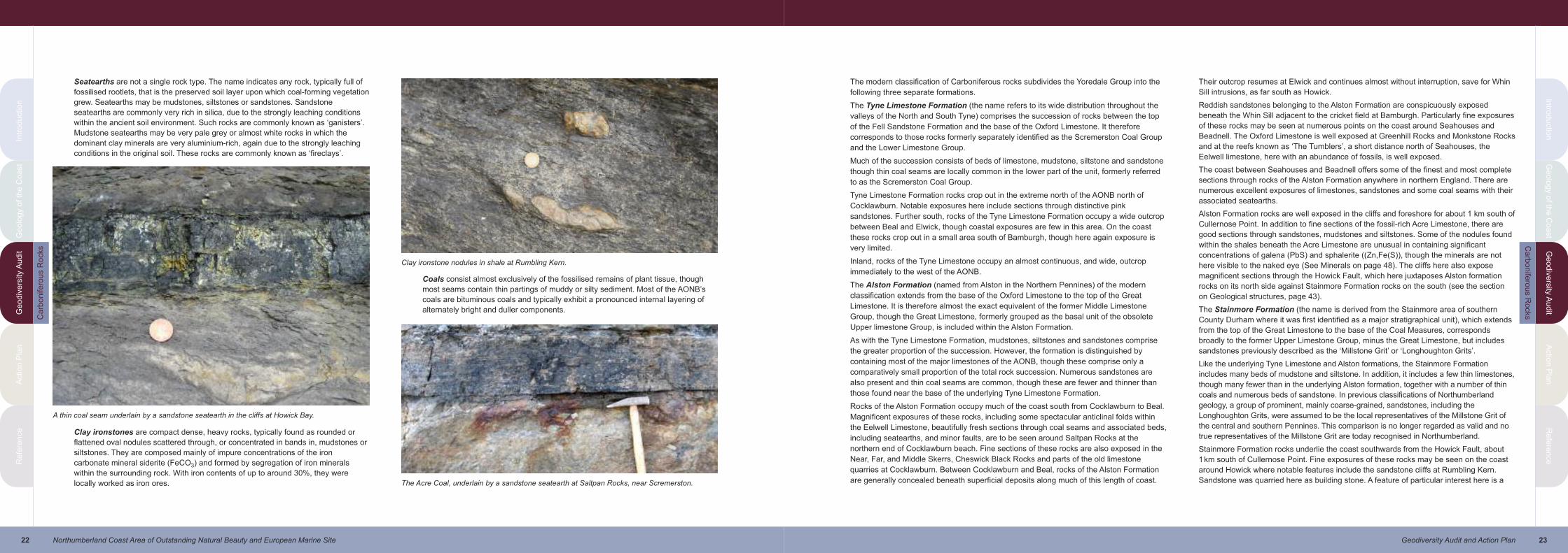
Seatearths are not a single rock type. The name indicates any rock, typically full of
fossilised rootlets, that is the preserved soil layer upon which coal-forming vegetation
grew. Seatearths may be mudstones, siltstones or sandstones. Sandstone
seatearths are commonly very rich in silica, due to the strongly leaching conditions
within the ancient soil environment. Such rocks are commonly known as ‘ganisters’.
Mudstone seatearths may be very pale grey or almost white rocks in which the
dominant clay minerals are very aluminium-rich, again due to the strongly leaching
conditions in the original soil. These rocks are commonly known as ‘fireclays’.
Clay ironstones are compact dense, heavy rocks, typically found as rounded or
flattened oval nodules scattered through, or concentrated in bands in, mudstones or
siltstones. They are composed mainly of impure concentrations of the iron
carbonate mineral siderite (FeCO3) and formed by segregation of iron minerals
within the surrounding rock. With iron contents of up to around 30%, they were
locally worked as iron ores.
Coals consist almost exclusively of the fossilised remains of plant tissue, though
most seams contain thin partings of muddy or silty sediment. Most of the AONB’s
coals are bituminous coals and typically exhibit a pronounced internal layering of
alternately bright and duller components.
A thin coal seam underlain by a sandstone seatearth in the cliffs at Howick Bay.
Clay ironstone nodules in shale at Rumbling Kern.
The Acre Coal, underlain by a sandstone seatearth at Saltpan Rocks, near Scremerston.
The modern classification of Carboniferous rocks subdivides the Yoredale Group into the
following three separate formations.
The Tyne Limestone Formation (the name refers to its wide distribution throughout the
valleys of the North and South Tyne) comprises the succession of rocks between the top
of the Fell Sandstone Formation and the base of the Oxford Limestone. It therefore
corresponds to those rocks formerly separately identified as the Scremerston Coal Group
and the Lower Limestone Group.
Much of the succession consists of beds of limestone, mudstone, siltstone and sandstone
though thin coal seams are locally common in the lower part of the unit, formerly referred
to as the Scremerston Coal Group.
Tyne Limestone Formation rocks crop out in the extreme north of the AONB north of
Cocklawburn. Notable exposures here include sections through distinctive pink
sandstones. Further south, rocks of the Tyne Limestone Formation occupy a wide outcrop
between Beal and Elwick, though coastal exposures are few in this area. On the coast
these rocks crop out in a small area south of Bamburgh, though here again exposure is
very limited.
Inland, rocks of the Tyne Limestone occupy an almost continuous, and wide, outcrop
immediately to the west of the AONB.
The Alston Formation (named from Alston in the Northern Pennines) of the modern
classification extends from the base of the Oxford Limestone to the top of the Great
Limestone. It is therefore almost the exact equivalent of the former Middle Limestone
Group, though the Great Limestone, formerly grouped as the basal unit of the obsolete
Upper limestone Group, is included within the Alston Formation.
As with the Tyne Limestone Formation, mudstones, siltstones and sandstones comprise
the greater proportion of the succession. However, the formation is distinguished by
containing most of the major limestones of the AONB, though these comprise only a
comparatively small proportion of the total rock succession. Numerous sandstones are
also present and thin coal seams are common, though these are fewer and thinner than
those found near the base of the underlying Tyne Limestone Formation.
Rocks of the Alston Formation occupy much of the coast south from Cocklawburn to Beal.
Magnificent exposures of these rocks, including some spectacular anticlinal folds within
the Eelwell Limestone, beautifully fresh sections through coal seams and associated beds,
including seatearths, and minor faults, are to be seen around Saltpan Rocks at the
northern end of Cocklawburn beach. Fine sections of these rocks are also exposed in the
Near, Far, and Middle Skerrs, Cheswick Black Rocks and parts of the old limestone
quarries at Cocklawburn. Between Cocklawburn and Beal, rocks of the Alston Formation
are generally concealed beneath superficial deposits along much of this length of coast.
Their outcrop resumes at Elwick and continues almost without interruption, save for Whin
Sill intrusions, as far south as Howick.
Reddish sandstones belonging to the Alston Formation are conspicuously exposed
beneath the Whin Sill adjacent to the cricket field at Bamburgh. Particularly fine exposures
of these rocks may be seen at numerous points on the coast around Seahouses and
Beadnell. The Oxford Limestone is well exposed at Greenhill Rocks and Monkstone Rocks
and at the reefs known as ‘The Tumblers’, a short distance north of Seahouses, the
Eelwell limestone, here with an abundance of fossils, is well exposed.
The coast between Seahouses and Beadnell offers some of the finest and most complete
sections through rocks of the Alston Formation anywhere in northern England. There are
numerous excellent exposures of limestones, sandstones and some coal seams with their
associated seatearths.
Alston Formation rocks are well exposed in the cliffs and foreshore for about 1 km south of
Cullernose Point. In addition to fine sections of the fossil-rich Acre Limestone, there are
good sections through sandstones, mudstones and siltstones. Some of the nodules found
within the shales beneath the Acre Limestone are unusual in containing significant
concentrations of galena (PbS) and sphalerite ((Zn,Fe(S)), though the minerals are not
here visible to the naked eye (See Minerals on page 48). The cliffs here also expose
magnificent sections through the Howick Fault, which here juxtaposes Alston formation
rocks on its north side against Stainmore Formation rocks on the south (see the section
on Geological structures, page 43).
The Stainmore Formation (the name is derived from the Stainmore area of southern
County Durham where it was first identified as a major stratigraphical unit), which extends
from the top of the Great Limestone to the base of the Coal Measures, corresponds
broadly to the former Upper Limestone Group, minus the Great Limestone, but includes
sandstones previously described as the ‘Millstone Grit’ or ‘Longhoughton Grits’.
Like the underlying Tyne Limestone and Alston formations, the Stainmore Formation
includes many beds of mudstone and siltstone. In addition, it includes a few thin limestones,
though many fewer than in the underlying Alston formation, together with a number of thin
coals and numerous beds of sandstone. In previous classifications of Northumberland
geology, a group of prominent, mainly coarse-grained, sandstones, including the
Longhoughton Grits, were assumed to be the local representatives of the Millstone Grit of
the central and southern Pennines. This comparison is no longer regarded as valid and no
true representatives of the Millstone Grit are today recognised in Northumberland.
Stainmore Formation rocks underlie the coast southwards from the Howick Fault, about
1km south of Cullernose Point. Fine exposures of these rocks may be seen on the coast
around Howick where notable features include the sandstone cliffs at Rumbling Kern.
Sandstone was quarried here as building stone. A feature of particular interest here is a
Ca
rbo
nife
rou
s R
ocks
Ca
rbo
nife
rou
s R
ocks
25Geodiversity Audit and Action Plan
Intro
du
ctio
nG
eo
log
y o
f the
Co
ast
Ge
od
ive
rsity
Au
dit
Actio
n P
lan
Re
fere
nce
Intr
od
uctio
nG
eo
log
y o
f th
e C
oa
st
Ge
od
ive
rsity A
ud
itA
ctio
n P
lan
Re
fere
nce
24 Northumberland Coast Area of Outstanding Natural Beauty and European Marine Site
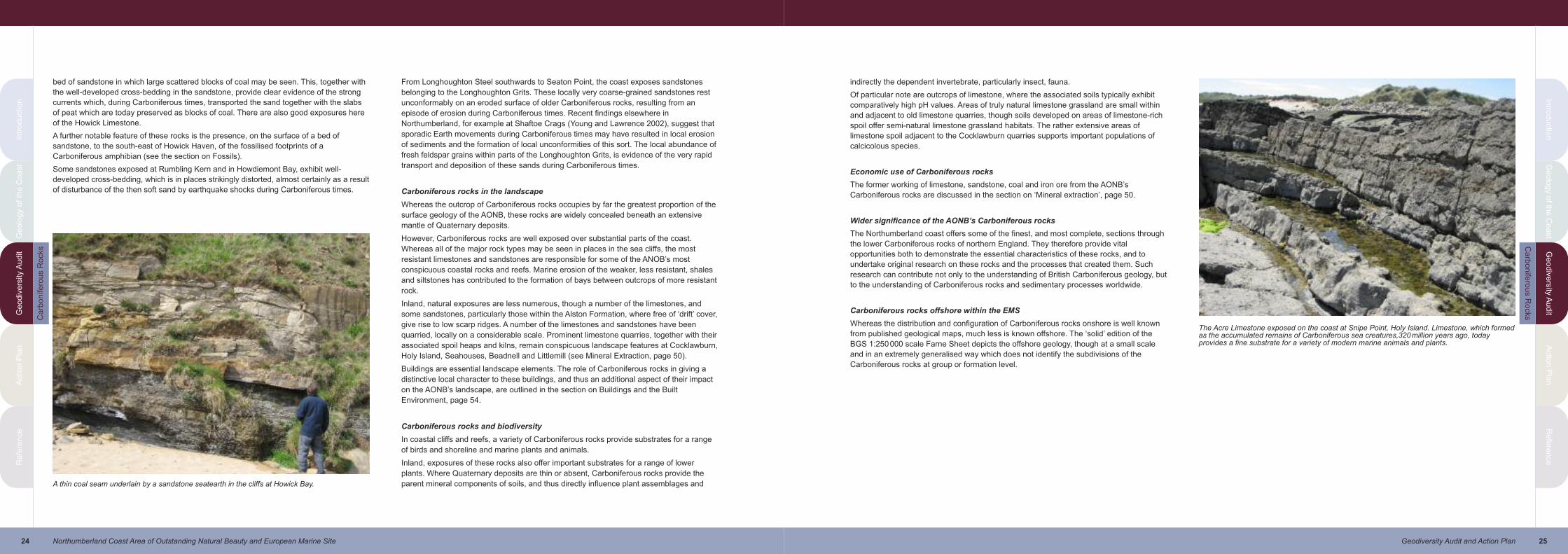
bed of sandstone in which large scattered blocks of coal may be seen. This, together with
the well-developed cross-bedding in the sandstone, provide clear evidence of the strong
currents which, during Carboniferous times, transported the sand together with the slabs
of peat which are today preserved as blocks of coal. There are also good exposures here
of the Howick Limestone.
A further notable feature of these rocks is the presence, on the surface of a bed of
sandstone, to the south-east of Howick Haven, of the fossilised footprints of a
Carboniferous amphibian (see the section on Fossils).
Some sandstones exposed at Rumbling Kern and in Howdiemont Bay, exhibit well-
developed cross-bedding, which is in places strikingly distorted, almost certainly as a result
of disturbance of the then soft sand by earthquake shocks during Carboniferous times.
From Longhoughton Steel southwards to Seaton Point, the coast exposes sandstones
belonging to the Longhoughton Grits. These locally very coarse-grained sandstones rest
unconformably on an eroded surface of older Carboniferous rocks, resulting from an
episode of erosion during Carboniferous times. Recent findings elsewhere in
Northumberland, for example at Shaftoe Crags (Young and Lawrence 2002), suggest that
sporadic Earth movements during Carboniferous times may have resulted in local erosion
of sediments and the formation of local unconformities of this sort. The local abundance of
fresh feldspar grains within parts of the Longhoughton Grits, is evidence of the very rapid
transport and deposition of these sands during Carboniferous times.
Carboniferous rocks in the landscape
Whereas the outcrop of Carboniferous rocks occupies by far the greatest proportion of the
surface geology of the AONB, these rocks are widely concealed beneath an extensive
mantle of Quaternary deposits.
However, Carboniferous rocks are well exposed over substantial parts of the coast.
Whereas all of the major rock types may be seen in places in the sea cliffs, the most
resistant limestones and sandstones are responsible for some of the ANOB’s most
conspicuous coastal rocks and reefs. Marine erosion of the weaker, less resistant, shales
and siltstones has contributed to the formation of bays between outcrops of more resistant
rock.
Inland, natural exposures are less numerous, though a number of the limestones, and
some sandstones, particularly those within the Alston Formation, where free of ‘drift’ cover,
give rise to low scarp ridges. A number of the limestones and sandstones have been
quarried, locally on a considerable scale. Prominent limestone quarries, together with their
associated spoil heaps and kilns, remain conspicuous landscape features at Cocklawburn,
Holy Island, Seahouses, Beadnell and Littlemill (see Mineral Extraction, page 50).
Buildings are essential landscape elements. The role of Carboniferous rocks in giving a
distinctive local character to these buildings, and thus an additional aspect of their impact
on the AONB’s landscape, are outlined in the section on Buildings and the Built
Environment, page 54.
Carboniferous rocks and biodiversity
In coastal cliffs and reefs, a variety of Carboniferous rocks provide substrates for a range
of birds and shoreline and marine plants and animals.
Inland, exposures of these rocks also offer important substrates for a range of lower
plants. Where Quaternary deposits are thin or absent, Carboniferous rocks provide the
parent mineral components of soils, and thus directly influence plant assemblages andA thin coal seam underlain by a sandstone seatearth in the cliffs at Howick Bay.
indirectly the dependent invertebrate, particularly insect, fauna.
Of particular note are outcrops of limestone, where the associated soils typically exhibit
comparatively high pH values. Areas of truly natural limestone grassland are small within
and adjacent to old limestone quarries, though soils developed on areas of limestone-rich
spoil offer semi-natural limestone grassland habitats. The rather extensive areas of
limestone spoil adjacent to the Cocklawburn quarries supports important populations of
calcicolous species.
Economic use of Carboniferous rocks
The former working of limestone, sandstone, coal and iron ore from the AONB’s
Carboniferous rocks are discussed in the section on ‘Mineral extraction’, page 50.
Wider significance of the AONB’s Carboniferous rocks
The Northumberland coast offers some of the finest, and most complete, sections through
the lower Carboniferous rocks of northern England. They therefore provide vital
opportunities both to demonstrate the essential characteristics of these rocks, and to
undertake original research on these rocks and the processes that created them. Such
research can contribute not only to the understanding of British Carboniferous geology, but
to the understanding of Carboniferous rocks and sedimentary processes worldwide.
Carboniferous rocks offshore within the EMS
Whereas the distribution and configuration of Carboniferous rocks onshore is well known
from published geological maps, much less is known offshore. The ‘solid’ edition of the
BGS 1:250000 scale Farne Sheet depicts the offshore geology, though at a small scale
and in an extremely generalised way which does not identify the subdivisions of the
Carboniferous rocks at group or formation level.
The Acre Limestone exposed on the coast at Snipe Point, Holy Island. Limestone, which formedas the accumulated remains of Carboniferous sea creatures,320million years ago, todayprovides a fine substrate for a variety of modern marine animals and plants.
Ca
rbo
nife
rou
s R
ocks
Ca
rbo
nife
rou
s R
ocks

27Geodiversity Audit and Action Plan
Intro
du
ctio
nG
eo
log
y o
f the
Co
ast
Ge
od
ive
rsity
Au
dit
Actio
n P
lan
Re
fere
nce
Intr
od
uctio
nG
eo
log
y o
f th
e C
oa
st
Ge
od
ive
rsity A
ud
itA
ctio
n P
lan
Re
fere
nce
26 Northumberland Coast Area of Outstanding Natural Beauty and European Marine Site
Permian Rocks
Permian rocks formed during the Permian Period of Earth history which extended from
about 295 to 245million years ago. The name Permian is derived from the Perm area of
Russia, where these rocks were first studied.
Permian rocks within the AONB
Permian rocks do not crop out within the onshore area of the AONB. The nearest onshore
outcrops lie several miles further south, in isolated outliers at Cullercoats and Tynemouth:
south of the River Tyne a continuous narrow outcrop of Permian rocks extends south to
the Midlands.
Permian rocks offshore within the EMS
The ‘solid’ edition of the BGS 1:250000 scale Farne Sheet depicts the offshore geology
(including the Permian rocks) of the entire EMS, though at a very small scale and in a very
generalised way. The Permian rocks in the offshore area to the south of the AONB and
EMS are depicted in more detail on the recently published BGS 1:50000 scale sheet 10
(Newbiggin). Permian rocks underlie a huge area of the North Sea, with the western edge
of their outcrop lying approximately 10kms east of the Farne Islands and about 12kms
east of Amble. Small thicknesses of these rocks are therefore likely to underlie parts of the
eastern extremities of the EMS.
Knowledge of these rocks comes mainly from numerous offshore boreholes, drilled both
for coal and hydrocarbon exploration. The Coal Measures rocks of the North East
Coalfield dip beneath the Permian rocks when followed eastwards beneath the North Sea,
and these Permian rocks are locally very important reservoirs for North Sea gas.
The Permian rocks of this part of the North Sea comprise part of the Zechstein Group, a
succession of dolomites and impure limestones with beds of anhydrite. These limestones
are the equivalents of the Magnesian Limestone of the Cullercoats and County Durham
areas. Poorly cemented sands belonging to the Rotliegende Group, which occur locally
beneath the limestones are the offshore equivalents of the Yellow Sands of the
Cullercoats, Tynemouth and County Durham areas.
Permian rocks, landscape and biodiversity
Whereas little appears to be known about the impact of these rocks on submarine
biodiversity, the widespread coverage of their outcrop by recent seabed sediments is likely
to render any such impact very small.
Intrusive Igneous Rocks—The Whin Sill swarm
Igneous rocks are rocks formed by the cooling and crystallisation of originally very hot
molten rock, or magma, from deep within the Earth. Magma extruded, or erupted, at the
surface of the Earth is known as lava. Depending upon its chemical composition, lava
cools to form a variety of extrusive igneous rocks. When magma does not reach the
surface, it may be intruded between layers or masses of pre-existing rocks. Here it cools
and crystallises and, depending upon its chemical composition, gives rise to a range of
intrusive igneous rocks. Intrusions of igneous rock may take a variety of forms, but two of
these are of particular importance in the AONB: roughly horizontal, sheet-like intrusions,
more or less parallel or concordant with the adjoining, or country, rocks, are known as sills;
roughly vertical, wall-like, intrusive bodies are known as dykes. Millions of years of
erosion may then expose these intrusive rocks at the surface. A variety of complex
analytical techniques may be used to date the crystallisation of these rocks. These dates,
when interpreted with other geological evidence, provide an extremely important means of
establishing accurate dates for key events in Earth history.
Introducing the Whin Sill swarm
Deep-seated stretching and fracturing of the Earth’s crust during late Carboniferous to
early Permian times, about 295million years ago, enabled huge volumes of magma to rise
from deep within the Earth. It did not reach the surface, but spread out between the layers
of Carboniferous rocks where it cooled and crystallised to form the extensive suite of sills
and dykes, collectively referred to today as the Whin Sill swarm.
The following very brief summary introduces those aspects of the Whin Sill that are vital to
understanding its fundamental place within the geodiversity of the AONB/EMS. More
detailed descriptions, together with references to some of the more technical literature, will
be found in the publications listed in the section on Information Sources and the selected
bibliography.
The Whin Sill swarm underlies an area of more than 4,500 square kilometres of North
East England. Its rocks reach the surface in an arcuate outcrop that extends southwards
from around Holy Island and the Kyloe Hills, through central Northumberland, along the
escarpments of the Hadrian’s Wall country and the North Pennine escarpment to
Lunedale and Teesdale. From this surface outcrop, the sills dip generally eastwards and
south-eastwards beneath southern Northumberland and eastern County Durham.
The sills remain concordant with the bedding of the Carboniferous country rocks over
large areas, though in places they abruptly change their stratigraphical horizon in a series
of steps. Over much of the outcrop the sill occurs as a single sheet, or leaf, but in places
two or more sheets or leaves, may be present one above the other: up to five such leaves
occur in the Kyloe Hills, a short distance to the west of the AONB.
In places large raft-like masses of country rock, detached by the intruding magma, and
known as xenoliths, occur within the main body of the sills.
Associated with these sills is a series of vertical dykes. Four belts of en echelon dykes
cross north-east England. From the north, these comprise the Holy Island, High Green, St
Oswald’s Chapel and Hett echelons. The first three occur in Northumberland: the fourth
lies in County Durham.
The sills and dykes of the Whin Sill swarm are composed of dolerite, commonly known
throughout Northumberland as ‘whinstone’. Dolerite is a fine- to medium-grained, dark-
grey to greenish-grey crystalline rock composed mainly of the minerals plagioclase
feldspar, pyroxene and iron and titanium oxides. A feature of the Whin Sill swarm is the
Bamburgh Castle occupies a naturally defensive site on a spectacular promontory of Whin Silldolerite. The base of the sill, in contact with reddish Carboniferous sandstone, is exposed at thefoot of the cliffs near the War Memorial.
Pe
rmia
n R
ocks
Wh
in S
ill

29Geodiversity Audit and Action Plan
Intro
du
ctio
nG
eo
log
y o
f the
Co
ast
Ge
od
ive
rsity
Au
dit
Actio
n P
lan
Re
fere
nce
Intr
od
uctio
nG
eo
log
y o
f th
e C
oa
st
Ge
od
ive
rsity A
ud
itA
ctio
n P
lan
Re
fere
nce
28 Northumberland Coast Area of Outstanding Natural Beauty and European Marine Site
continuity of its mineralogical and chemical composition across the whole of its wide
outcrop. Most abundant is fine- to medium-grained dolerite, though very fine-grained,
almost glassy, varieties of dolerite occur as narrow selvages where the magma cooled, or
chilled, very rapidly against the much cooler country rocks. In places, very coarsely-
crystalline dolerite, known as dolerite pegmatite, occurs near the centre of the intrusions,
and in places there are small concentrations of pink felsitic material, though these rocks
are uncommon in the AONB.
In places, rounded cavities, up to a few centimetres across, and known as vesicles,
represent pockets of gas within the molten magma. Most commonly these have been filled
with later formed minerals such as calcite or quartz: such filled cavities are known as
amygdales.
The rocks adjacent to the sills and dykes, and the xenoliths of country rock, have usually
been altered, or metamorphosed, by the great heat of the intrusion. These metamorphic
rocks are discussed below.
Vein of pink felsitic rock within a block of grey Whin Sill dolerite in a wall at Craster. Thesefelsitic veins are comparatively common at nearby Cushat Shiel, on the coast nearDunstanburgh Castle.
Calcite-filled amygdales in Whin Sill dolerite at Harkess Rocks.
A common, and very striking, feature of the Whin Sill dolerite is the conspicuous pattern of
vertical fractures, along which the rock breaks readily into rough hexagonal columns. This
columnar jointing, which is a common feature of many sills and lavas, formed by
contraction of the rock during its final stages of cooling. Spectacular though this jointing is
in parts of the Whin Sill it does not match the regularity of the columnar jointing seen in the
basalts of the Giant’s Causeway and Fingal’s Cave, on the Hebridean Isle of Staffa.
Radiometric dating of the Whin Sill dolerite indicates that it was intruded about 295million
years ago. Detailed studies of magnetic minerals within the dolerite suggest that, at the time
of its intrusion, the area we know today as North East England lay within tropical latitudes.
Naming the Whin Sill
Like so many names used in geology throughout the world, that of the Whin Sill is derived
from the everyday vocabulary of quarrymen and miners. For centuries Northumbrian
miners and quarrymen have used the term ‘sill’ for any more or less horizontal body of
rock, irrespective of its mode of origin. Thus, in parts of northern England we encounter,
for example, the Grindstone Sill, a sandstone well-suited to making grindstones or
millstones, the Slate Sills, a group of sandstones suitable for making roofing slabs, and
many others. ‘Whin’ is an old term used by quarrymen for any very dark coloured hard
rock that is difficult to shape. It is said that the word ‘whin’ derives from the distinctive
whistling “whinnnn…” noise made by fragments as they are broken from large blocks,
though the common occurrence of gorse, or whin, bushes on its outcrops have also been
cited as the origin of its name.
When the intrusive nature of Northumberland’s Whin Sill was established in the 19th
century, the term ‘sill’ was quickly adopted by geological science worldwide for all such
roughly horizontal concordant intrusions. The Whin Sill is thus the original sill of geological
science.
Cullernose Point. The Whin Sill here exhibits perhaps the finest example of columnar jointing tobe seen along the coast.
Wh
in S
illW
hin
Sill

31Geodiversity Audit and Action Plan
Intro
du
ctio
nG
eo
log
y o
f the
Co
ast
Ge
od
ive
rsity
Au
dit
Actio
n P
lan
Re
fere
nce
Intr
od
uctio
nG
eo
log
y o
f th
e C
oa
st
Ge
od
ive
rsity A
ud
itA
ctio
n P
lan
Re
fere
nce
30 Northumberland Coast Area of Outstanding Natural Beauty and European Marine Site
The Whin Sill within the AONB/EMS
This suite of intrusive igneous rocks is one of Northumberland’s best known geological
features and is of particular importance in the AONB/EMS.
Within the AONB, parts of the Whin Sill swarm crop out on Holy Island (Lindisfarne), the
Farne Islands, between Budle Bay and Bamburgh, near Newton by the Sea, and between
Dunstanburgh Castle and Howick. Over much of the AONB, and adjoining country, the
Whin Sill comprises sheet-like sills of dolerite, though narrow vertical dykes are known, for
example at Boulmer, Embleton Bay and south of Cullernose Point.
Although the intrusions crop out widely inland, where they form important landscape
features and may be seen in numerous abandoned quarries, the finest exposures of these
rocks are to be seen in coastal cliffs, islands and reefs. Excellent sections are also
exposed in working and recently abandoned quarries a short distance west of the
boundary of the AONB.
Such is the quality and geological importance of the coastal exposures that much of
shoreline outcrop of the Whin Sill within the AONB lies within a number of sites protected
under the Geological Conservation Review (GCR). Detailed descriptions and
interpretations of the numerous features of interest exposed in these areas are to be
found in the appropriate GCR Volume (Stephenson et al., 2003). Only a brief summary of
the most important Whin Sill features within the AONB is presented below.
Of particular importance are the Whin Sill dyke exposures on Holy Island. Most
conspicuous of these is the rocky knoll upon which the Castle is sited, though other
important outcrops are present at St Cuthbert’s Isle, Heugh Hill and Jockey Scar. Notable
features of the sill here include distinctive arcuate, ripple-like surfaces within lower parts of
gas cavities, or vesicles, within the dolerite. These are almost identical to the so-called
ropy textures found on the upper surfaces of modern lava flows in places such as Hawaii:
the Hawaiin name ‘pahoehoe’ is used by geologists for this structure. The texture results
from the flow of still molten magma beneath a solidified, or almost solidified, crust.
Whereas Whin Sill magma was never erupted at the surface as lava, these remarkable
structures give clear evidence that it was intruded at comparatively shallow depths
(perhaps as little as a few tens of metres) beneath the surface. Slabs, or xenoliths, of
Carboniferous rocks, intensely altered by the heat of the dolerite magma, are present in
the Heugh Hill outcrop. Structures within the Whin Sill rocks on Holy Island have led to
suggestions that the present day upper surface of the Holy Island Dyke lies close to the
top of the intrusion. However, modern studies suggest that the intrusion here comprises a
series of upward steps resulting in alternating dyke-like and sill-like intrusions.
At Harkess Rocks, north of Bamburgh, numerous fine examples of pahoehoe structures,
like those at Holy Island may also be seen. The presence of pahoehoe structures in an
intrusion of this sort is highly unusual and may be unique worldwide. Clear sections of
cross-cutting relationships where the sill changes position from one horizon of
Carboniferous rocks to another, are a feature of this section of coast.
The cliffs between Castle Point and Cullernose Point provide spectacular exposures of
Whin Sill rocks. Features of particular interest here include numerous highly altered
xenoliths of Carboniferous rocks engulfed within the sill (see the section on Metamorphic
Rocks, below), and the presence of amygdales — large quartz and calcite-filled gas
cavities within the dolerite (see the section on Minerals, below).
At Cushat Shiel, near Dunstanburgh Castle, the dark grey dolerite contains numerous
veins and pods of pink felsitic rock up to about 5cm across. These rocks give evidence of
the changing composition of the Whin Sill magma during its final stages of crystallisation.
The cliffs of Cullernose point exhibit some of the finest columnar jointing seen within the
Whin Sill of the AONB.
A few metres south of Cullernose Point, the vertical Cullernose Dyke occupies a fault
cutting Carboniferous rocks. Xenoliths of broken rock (fault breccia) from the fault,
included within the dolerite of the dyke, indicate that the dyke was intruded after initial
formation of the fault.
Dyke of Whin Sill dolerite cutting Carboniferous rocks south of Cullernose Point.
The Holy Island Dyke forms the prominent ridge of Heugh Hill and Steel End, with Holy IslandCastle in the distance standing on a further promontory formed of this rock.
Pahoehoe in Whin Sill dolerite exposed at Harkess Rocks, near Bamburgh.
Vertical Whin Sill sea cliffs at Castle Point.
Wh
in S
illW
hin
Sill
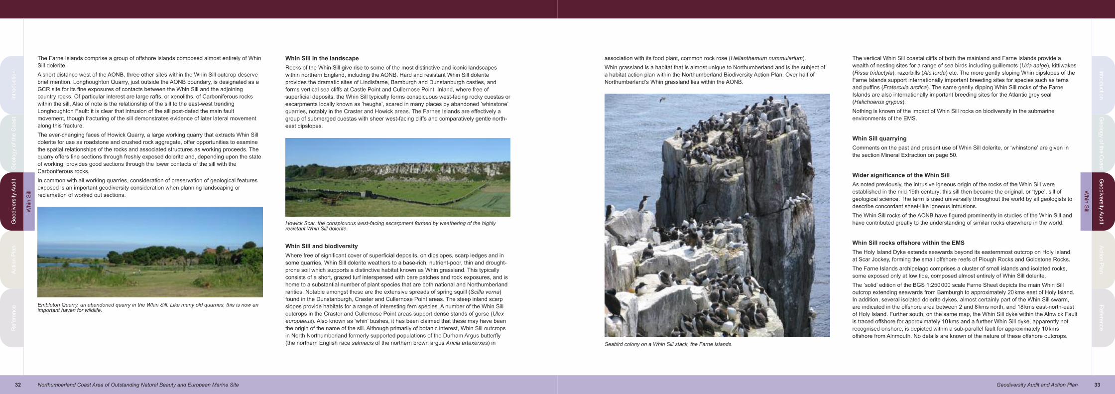
33Geodiversity Audit and Action Plan
Intro
du
ctio
nG
eo
log
y o
f the
Co
ast
Ge
od
ive
rsity
Au
dit
Actio
n P
lan
Re
fere
nce
Intr
od
uctio
nG
eo
log
y o
f th
e C
oa
st
Ge
od
ive
rsity A
ud
itA
ctio
n P
lan
Re
fere
nce
32 Northumberland Coast Area of Outstanding Natural Beauty and European Marine Site
The Farne Islands comprise a group of offshore islands composed almost entirely of Whin
Sill dolerite.
A short distance west of the AONB, three other sites within the Whin Sill outcrop deserve
brief mention. Longhoughton Quarry, just outside the AONB boundary, is designated as a
GCR site for its fine exposures of contacts between the Whin Sill and the adjoining
country rocks. Of particular interest are large rafts, or xenoliths, of Carboniferous rocks
within the sill. Also of note is the relationship of the sill to the east-west trending
Longhoughton Fault: it is clear that intrusion of the sill post-dated the main fault
movement, though fracturing of the sill demonstrates evidence of later lateral movement
along this fracture.
The ever-changing faces of Howick Quarry, a large working quarry that extracts Whin Sill
dolerite for use as roadstone and crushed rock aggregate, offer opportunities to examine
the spatial relationships of the rocks and associated structures as working proceeds. The
quarry offers fine sections through freshly exposed dolerite and, depending upon the state
of working, provides good sections through the lower contacts of the sill with the
Carboniferous rocks.
In common with all working quarries, consideration of preservation of geological features
exposed is an important geodiversity consideration when planning landscaping or
reclamation of worked out sections.
Whin Sill in the landscape
Rocks of the Whin Sill give rise to some of the most distinctive and iconic landscapes
within northern England, including the AONB. Hard and resistant Whin Sill dolerite
provides the dramatic sites of Lindisfarne, Bamburgh and Dunstanburgh castles, and
forms vertical sea cliffs at Castle Point and Cullernose Point. Inland, where free of
superficial deposits, the Whin Sill typically forms conspicuous west-facing rocky cuestas or
escarpments locally known as ‘heughs’, scared in many places by abandoned ‘whinstone’
quarries, notably in the Craster and Howick areas. The Farnes Islands are effectively a
group of submerged cuestas with sheer west-facing cliffs and comparatively gentle north-
east dipslopes.
Whin Sill and biodiversity
Where free of significant cover of superficial deposits, on dipslopes, scarp ledges and in
some quarries, Whin Sill dolerite weathers to a base-rich, nutrient-poor, thin and drought-
prone soil which supports a distinctive habitat known as Whin grassland. This typically
consists of a short, grazed turf interspersed with bare patches and rock exposures, and is
home to a substantial number of plant species that are both national and Northumberland
rarities. Notable amongst these are the extensive spreads of spring squill (Scilla verna)
found in the Dunstanburgh, Craster and Cullernose Point areas. The steep inland scarp
slopes provide habitats for a range of interesting fern species. A number of the Whin Sill
outcrops in the Craster and Cullernose Point areas support dense stands of gorse (Ulex
europaeus). Also known as ‘whin’ bushes, it has been claimed that these may have been
the origin of the name of the sill. Although primarily of botanic interest, Whin Sill outcrops
in North Northumberland formerly supported populations of the Durham Argus butterfly
(the northern English race salmacis of the northern brown argus Aricia artaxerxes) in
association with its food plant, common rock rose (Helianthemum nummularium).
Whin grassland is a habitat that is almost unique to Northumberland and is the subject of
a habitat action plan within the Northumberland Biodiversity Action Plan. Over half of
Northumberland’s Whin grassland lies within the AONB.
The vertical Whin Sill coastal cliffs of both the mainland and Farne Islands provide a
wealth of nesting sites for a range of sea birds including guillemots (Uria aalge), kittiwakes
(Rissa tridactyla), razorbills (Alc torda) etc. The more gently sloping Whin dipslopes of the
Farne Islands support internationally important breeding sites for species such as terns
and puffins (Fratercula arctica). The same gently dipping Whin Sill rocks of the Farne
Islands are also internationally important breeding sites for the Atlantic grey seal
(Halichoerus grypus).
Nothing is known of the impact of Whin Sill rocks on biodiversity in the submarine
environments of the EMS.
Whin Sill quarrying
Comments on the past and present use of Whin Sill dolerite, or ‘whinstone’ are given in
the section Mineral Extraction on page 50.
Wider significance of the Whin Sill
As noted previously, the intrusive igneous origin of the rocks of the Whin Sill were
established in the mid 19th century; this sill then became the original, or ‘type’, sill of
geological science. The term is used universally throughout the world by all geologists to
describe concordant sheet-like igneous intrusions.
The Whin Sill rocks of the AONB have figured prominently in studies of the Whin Sill and
have contributed greatly to the understanding of similar rocks elsewhere in the world.
Whin Sill rocks offshore within the EMS
The Holy Island Dyke extends seawards beyond its easternmost outcrop on Holy Island,
at Scar Jockey, forming the small offshore reefs of Plough Rocks and Goldstone Rocks.
The Farne Islands archipelago comprises a cluster of small islands and isolated rocks,
some exposed only at low tide, composed almost entirely of Whin Sill dolerite.
The ‘solid’ edition of the BGS 1:250000 scale Farne Sheet depicts the main Whin Sill
outcrop extending seawards from Bamburgh to approximately 20kms east of Holy Island.
In addition, several isolated dolerite dykes, almost certainly part of the Whin Sill swarm,
are indicated in the offshore area between 2 and 8kms north, and 18kms east-north-east
of Holy Island. Further south, on the same map, the Whin Sill dyke within the Alnwick Fault
is traced offshore for approximately 10kms and a further Whin Sill dyke, apparently not
recognised onshore, is depicted within a sub-parallel fault for approximately 10kms
offshore from Alnmouth. No details are known of the nature of these offshore outcrops.
Embleton Quarry, an abandoned quarry in the Whin Sill. Like many old quarries, this is now animportant haven for wildlife.
Howick Scar, the conspicuous west-facing escarpment formed by weathering of the highlyresistant Whin Sill dolerite.
Seabird colony on a Whin Sill stack, the Farne Islands.
Wh
in S
illW
hin
Sill
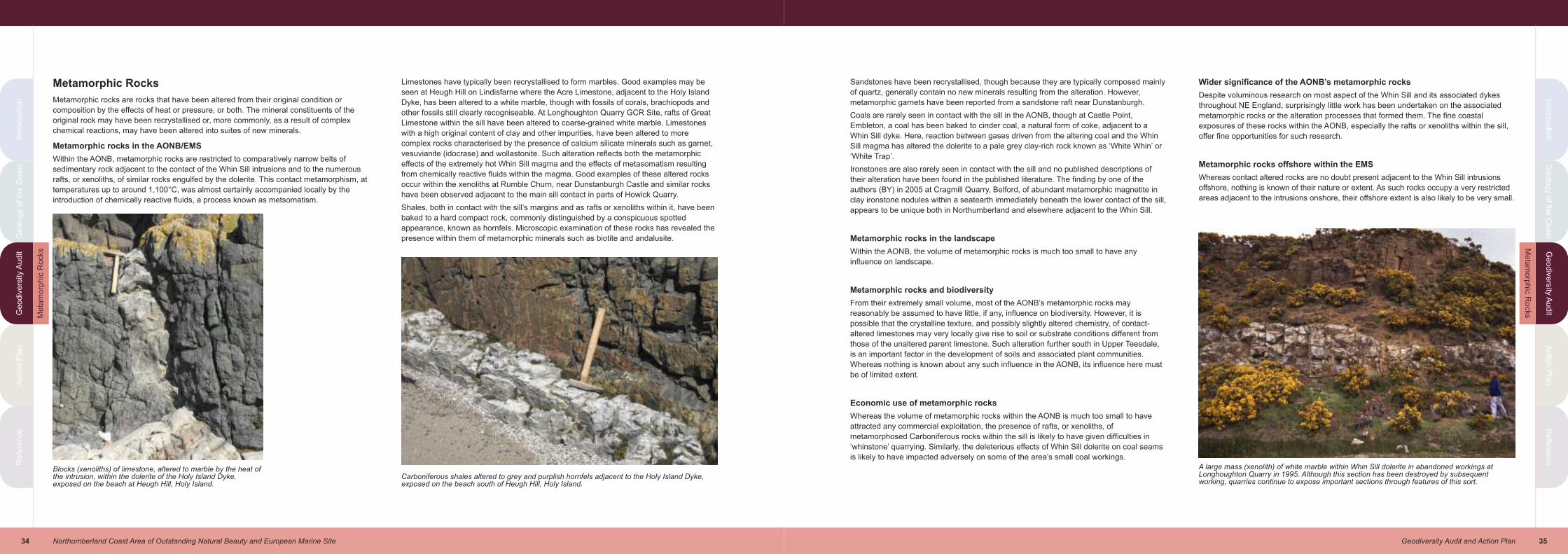
35Geodiversity Audit and Action Plan
Intro
du
ctio
nG
eo
log
y o
f the
Co
ast
Ge
od
ive
rsity
Au
dit
Actio
n P
lan
Re
fere
nce
Intr
od
uctio
nG
eo
log
y o
f th
e C
oa
st
Ge
od
ive
rsity A
ud
itA
ctio
n P
lan
Re
fere
nce
34 Northumberland Coast Area of Outstanding Natural Beauty and European Marine Site
Metamorphic Rocks
Metamorphic rocks are rocks that have been altered from their original condition or
composition by the effects of heat or pressure, or both. The mineral constituents of the
original rock may have been recrystallised or, more commonly, as a result of complex
chemical reactions, may have been altered into suites of new minerals.
Metamorphic rocks in the AONB/EMS
Within the AONB, metamorphic rocks are restricted to comparatively narrow belts of
sedimentary rock adjacent to the contact of the Whin Sill intrusions and to the numerous
rafts, or xenoliths, of similar rocks engulfed by the dolerite. This contact metamorphism, at
temperatures up to around 1,100°C, was almost certainly accompanied locally by the
introduction of chemically reactive fluids, a process known as metsomatism.
Limestones have typically been recrystallised to form marbles. Good examples may be
seen at Heugh Hill on Lindisfarne where the Acre Limestone, adjacent to the Holy Island
Dyke, has been altered to a white marble, though with fossils of corals, brachiopods and
other fossils still clearly recogniseable. At Longhoughton Quarry GCR Site, rafts of Great
Limestone within the sill have been altered to coarse-grained white marble. Limestones
with a high original content of clay and other impurities, have been altered to more
complex rocks characterised by the presence of calcium silicate minerals such as garnet,
vesuvianite (idocrase) and wollastonite. Such alteration reflects both the metamorphic
effects of the extremely hot Whin Sill magma and the effects of metasomatism resulting
from chemically reactive fluids within the magma. Good examples of these altered rocks
occur within the xenoliths at Rumble Churn, near Dunstanburgh Castle and similar rocks
have been observed adjacent to the main sill contact in parts of Howick Quarry.
Shales, both in contact with the sill’s margins and as rafts or xenoliths within it, have been
baked to a hard compact rock, commonly distinguished by a conspicuous spotted
appearance, known as hornfels. Microscopic examination of these rocks has revealed the
presence within them of metamorphic minerals such as biotite and andalusite.
Sandstones have been recrystallised, though because they are typically composed mainly
of quartz, generally contain no new minerals resulting from the alteration. However,
metamorphic garnets have been reported from a sandstone raft near Dunstanburgh.
Coals are rarely seen in contact with the sill in the AONB, though at Castle Point,
Embleton, a coal has been baked to cinder coal, a natural form of coke, adjacent to a
Whin Sill dyke. Here, reaction between gases driven from the altering coal and the Whin
Sill magma has altered the dolerite to a pale grey clay-rich rock known as ‘White Whin’ or
‘White Trap’.
Ironstones are also rarely seen in contact with the sill and no published descriptions of
their alteration have been found in the published literature. The finding by one of the
authors (BY) in 2005 at Cragmill Quarry, Belford, of abundant metamorphic magnetite in
clay ironstone nodules within a seatearth immediately beneath the lower contact of the sill,
appears to be unique both in Northumberland and elsewhere adjacent to the Whin Sill.
Metamorphic rocks in the landscape
Within the AONB, the volume of metamorphic rocks is much too small to have any
influence on landscape.
Metamorphic rocks and biodiversity
From their extremely small volume, most of the AONB’s metamorphic rocks may
reasonably be assumed to have little, if any, influence on biodiversity. However, it is
possible that the crystalline texture, and possibly slightly altered chemistry, of contact-
altered limestones may very locally give rise to soil or substrate conditions different from
those of the unaltered parent limestone. Such alteration further south in Upper Teesdale,
is an important factor in the development of soils and associated plant communities.
Whereas nothing is known about any such influence in the AONB, its influence here must
be of limited extent.
Economic use of metamorphic rocks
Whereas the volume of metamorphic rocks within the AONB is much too small to have
attracted any commercial exploitation, the presence of rafts, or xenoliths, of
metamorphosed Carboniferous rocks within the sill is likely to have given difficulties in
‘whinstone’ quarrying. Similarly, the deleterious effects of Whin Sill dolerite on coal seams
is likely to have impacted adversely on some of the area’s small coal workings.
Wider significance of the AONB’s metamorphic rocks
Despite voluminous research on most aspect of the Whin Sill and its associated dykes
throughout NE England, surprisingly little work has been undertaken on the associated
metamorphic rocks or the alteration processes that formed them. The fine coastal
exposures of these rocks within the AONB, especially the rafts or xenoliths within the sill,
offer fine opportunities for such research.
Metamorphic rocks offshore within the EMS
Whereas contact altered rocks are no doubt present adjacent to the Whin Sill intrusions
offshore, nothing is known of their nature or extent. As such rocks occupy a very restricted
areas adjacent to the intrusions onshore, their offshore extent is also likely to be very small.
Blocks (xenoliths) of limestone, altered to marble by the heat ofthe intrusion, within the dolerite of the Holy Island Dyke,exposed on the beach at Heugh Hill, Holy Island.
Carboniferous shales altered to grey and purplish hornfels adjacent to the Holy Island Dyke,exposed on the beach south of Heugh Hill, Holy Island.
A large mass (xenolith) of white marble within Whin Sill dolerite in abandoned workings atLonghoughton Quarry in 1995. Although this section has been destroyed by subsequentworking, quarries continue to expose important sections through features of this sort.
Me
tam
orp
hic
Ro
cks
Me
tam
orp
hic
Ro
cks

37Geodiversity Audit and Action Plan
Intro
du
ctio
nG
eo
log
y o
f the
Co
ast
Ge
od
ive
rsity
Au
dit
Actio
n P
lan
Re
fere
nce
Intr
od
uctio
nG
eo
log
y o
f th
e C
oa
st
Ge
od
ive
rsity A
ud
itA
ctio
n P
lan
Re
fere
nce
36 Northumberland Coast Area of Outstanding Natural Beauty and European Marine Site
Quaternary Deposits and Landforms
The Quaternary Period spans the last 2.5million years of geological history. Over much of
northern Europe the beginning of this period was marked by a pronounced episode of
global cooling which resulted in the formation of thick ice sheets, at times over 1km thick,
which covered much of Great Britain and Northern Europe. Throughout Quaternary times,
the climate alternated between colder (glacial) and warmer (interglacial) stages. Several
such glacial and interglacial stages are known to have affected Britain, though the majority
of the deposits and landforms preserved today are believed to date from the most recent
glacial period, known as the Devensian, which in Northumberland ended about 11,000
years ago. During glacial episodes, thick ice sheets scoured and modified the pre-existing
landscape, creating vast amounts of glacial debris which was deposited beneath or on top
of the ice sheets, or transported to adjoining areas by both the ice and meltwater.
Since the final melting of the last ice sheets, the most recent episode of geological time, in
which we are living today, is known as the Holocene Epoch. Earth processes operating
during that time, many of which are still active today, have produced a variety of geological
materials.
Much of the present day form of the physical landscape, or geomorphology, of the
AONB is a result of Earth processes that have affected the area during and after the last
glacial period.
Quaternary deposits and landforms in the AONB
Over large areas the ‘solid’ Carboniferous and Whin Sill rocks of the AONB are concealed
by an extensive mantle composed of a variety of unconsolidated ‘drift’ deposits formed
during and since the most recent glacial episode, the Devensian.
A large volume of research has been undertaken on the complex pattern of ice flow and
related processes during Devensian times in Northumberland. One of the most up-to-date
reviews of these processes, and their effects on landscape formation, is that presented in
the Geodiversity Audit and Action Plan for the nearby Northumberland National Park
(Lawrence et al., 2007). From these studies it is clear that the AONB was heavily scoured
by ice which originated mainly in southern Scotland, the Lake District and west and central
Northumberland. As this flowed eastwards, it was deflected around the Cheviot massif
which at that time supported its own rather static ice cap. On reaching the area of the
present coast, this ice met a thick ice sheet, of Scandinavian origin, covering what is today
the North Sea. This deflected the main ice stream towards the south or south-east,
roughly parallel with the modern coastline.
A variety of deposits were formed by this ice and by meltwaters as the ice sheets finally
decayed and disappeared around 11,000 years ago. The effects of comparatively rapid
changes in sea level following this melting, resulting from a combination of relative sea
level rises and ‘rebound’ of the land surface when relieved of the weight of ice, may be
recognised in parts of the AONB.
Brief comments on the different Quaternary materials present within the AONB follow,
accompanied by comments of their impact upon landscape, biodiversity etc.
Till (or boulder clay)
The ‘drift’ maps of the British Geological Survey depict extensive areas of the AONB
mantled by spreads of boulder clay, though this term has been generally superseded
today by the term till. Across much of northern England, including the AONB, till typically
consists of a heterogeneous assortment of grey or brown silty or sandy clay in which
occur rock fragments which range in size from gravel up to large boulders. The variety of
rock fragments within the till give clear evidence of its source, and thus the direction of ice
flow (see Erratics, below).
Detailed descriptions of the ’drift’ geology in the Geological Survey memoirs, recognise
two till sheets, separated by beds of sand and gravel and laminated clay. The lower clay is
typically grey in colour and dominated by boulders of local rock types. The upper clay is
commonly reddish purple with more far-travelled erratic blocks.
Important sections of till with associated sand and gravel deposits, exposed on the coast
at Sandy Bay, are designated as a GCR site.
The till varies widely in thickness, though over much of the coast it generally does not
exceed a few metres. Till-covered ground typically exhibits a smooth or gently undulating
surface, commonly with damp, poorly-drained soils in hollows or low-lying areas.
At Kelsoe Hill, near Embleton, a bare Whin Sill dolerite crag is associated with a long ‘tail’
of till, on its south-eastern side, of till. Such ‘crag and tail’ landforms are comparatively
common in glaciated areas with local outcrops of hard resistant rock. They indicate, as in
this example, the direction of ice flow. The small crag of hard rock has protected the softer
till on its lee side from the scouring effects of the over-riding ice.
Erratics
These are glacially transported boulders or fragments of rock found within till, many of
which, from their distinctive characteristics, may be traced back to their original bed-rock
source. They therefore give clear evidence of the direction of ice flow. In addition to an
abundance of locally derived sandstones, limestones and Whin Sill dolerite, erratics within
the AONB include an abundance of greywacke sandstones from southern Scotland, and a
variety of volcanic rocks and some blocks of granite from the Cheviots.
At a few places on the shore, small boulders of rocks that may be recognised as having a
Scandinavian origin, may be found. These include a variety of gneisses and granitic rocks,
together with rarer examples of striking rocks, known as ‘rhomb porphyries’. These are
fine-to-medium-grained varieties of the rock known as microsyenite from the Oslo district,
characterised by the presence of conspicuous large rhomb-shaped feldspar crystals.
Whereas most erratics are of boulder size or smaller, north-east England is noted for the
local presence of very large, or giant, erratics. Within the AONB a large erratic slab of
coarse-grained sandstone, at least 56m long, embedded in till, has been described from
the low sea cliff at Emanuel Head at the north-east corner of Holy Island. A smaller slab of
sandstone, about 18m long and up to 1.5m thick has been recorded from the sea cliff at
Birling Carrs, north of Warkworth. These, and other very much larger erratic blocks, known
from elsewhere in North East England, indicate very clearly the immense power of ice
sheets to transport eroded material.
Boulder clay, or till, exposed in cliffs near Longhoughton Steel. Blocks and pebbles ofsandstone, limestone and Whin Sill dolerite in sandy clay matrix.
Kelsoe Hill, near Embleton. A ‘crag and tail’ feature: an outcrop ofresistant Whin Sill dolerite forms a low ‘crag’ on the north side of the hill(left in photograph) with a ‘tail’ of boulder clay, or till (right ofphotograph).
Erratic boulders of volcanic rocks from the Cheviot Hills on the beach at CovesHaven, Holy Island.
Qu
ate
rna
ry R
ocks
Qu
ate
rna
ry R
ocks

39Geodiversity Audit and Action Plan
Intro
du
ctio
nG
eo
log
y o
f the
Co
ast
Ge
od
ive
rsity
Au
dit
Actio
n P
lan
Re
fere
nce
Intr
od
uctio
nG
eo
log
y o
f th
e C
oa
st
Ge
od
ive
rsity A
ud
itA
ctio
n P
lan
Re
fere
nce
38 Northumberland Coast Area of Outstanding Natural Beauty and European Marine Site
Glacial striae
As blocks of rock are ground together within a moving ice sheet, or as the ice sheet
scours the rock floor over which it is moving, these rock fragments scratch deeply into one
another. When exposed by weathering or quarrying, the bare rock surface (rockhead)
beneath a sheet of till commonly exhibits deep grooves or striae, gouged out in this way.
The striae are generally parallel, or nearly so, giving a clear indication of the direction of
flow. Striae are best preserved on durable fine-grained rocks such as dolerite or
limestone. Good examples are recorded on dolerite from the Farne Islands, near
Cullernose Point and Littlemill Station, and on limestone at the old quarry west of Littlemill.
Similar striations are extremely common on erratic boulders within till.
Sand and gravel
Beds of sand and gravel, of varying coarseness, lie within or between the beds of till. In
addition, numerous, mostly small, patches of sand and gravel are mapped throughout the
AONB, though with the greatest concentration in the Aln valley between Alnwick and
Alnmouth. These deposits are the products of glacial meltwater, either during glaciation or
during the final melting of the ice sheets.
Of particular importance is the long sinuous ridge of gravel, known as the Bradford Kame,
which lies a short distance to the west of the AONB. The Bradford Kame Complex
comprises a complicated assemblage of mounds and sinuous ridges composed of silt,
sand and gravel. Perhaps the most obvious part of the complex is the very prominent
ridges, known as eskers, which locally resemble large partially degraded railway
embankments. These are conspicuous landscape features between Spindlestone and
Pigdon Hill and between Newham and Preston, to the west of the AONB. The Bradford
Kame Complex has long been the subject of detailed research and a variety of
interpretations have been proposed to account for its origins. However, it seems likely that
the main esker ridges formed as gravel-filled channels beneath or within an ice sheet:
associated spreads of gravel, sand and silt may be the products of deltas deposited by
meltwaters draining into glacial lakes. The importance of the Bradford Kame Complex in
the understanding of Quaternary geology and processes in recognised in its designation
as a GCR site.
Peat
Peat occupies small hollows, almost all of which were probably small lakes formed soon
after the melting of the last ice sheets, at a few places immediately west of the AONB. The
largest are those at Holburn Moss and Embleton Bog. At the former site, peat fills hollows
in the hilly topography of the Fell Sandstone outcrop. The latter is the largest of a number
of hollows in the Quaternary deposits including the gravels of the Bradford Kame.
Holburn Moss and Newham Fen are internationally important biodiversity sites. On the
Farne Islands, thin patches of sandy maritime peat, too small to be depicted on the
published 1:50000 scale BGS map, rest on till and locally Whin Sill bedrock, and provide
the main sites for puffin burrows.
Submerged forests
At numerous places on the British coast the remains of forest vegetation, below modern
high tide levels, give clear evidence of significant post-glacial sea level changes. Within
the AONB, very small remnants of such vegetation, including the remains of oak (Quercus
sp.), alder (Alnus glutinosa) and hazel (Corylus avellana), some in original growth position,
have been described from Howick Haven. Better known, and more extensive submerged
forest remains are those at Druridge Bay, a short distance south of the AONB. Radio
carbon dating of the organic remains from Druridge Bay reveals that forest growth and
peat formation here occurred between 4700 and 2800 radiocarbon years before present.
Alluvium and river terrace deposits
These include a great variety of sediments ranging from clays, through silts and sands to
coarse gravels. Modern alluvial deposits flank many stream and river courses and are still
accumulating, principally during flooding events. In addition, alluvial deposits occur in
hollows formerly occupied by lakes or ponds, for example in the numerous small bogs
associated with the hummocky topography adjacent to the Bradford Kame and similar
deposits in the Spindlestone area. Accumulations of shell marl, a limy deposit formed
principally of freshwater shell debris, are present in some of these bogs.
River terrace deposits are alluvial deposits that accumulated in response to higher base
levels during Holocene times.
Raised and storm beach deposits
Raised beach deposits comprise sands and gravels, usually indistinguishable from
modern beach deposits, but situated at elevations well above present sea level. They are
the remnants of beaches developed during periods of higher relative sea level during the
Holocene Epoch.
Beach deposits at elevations of approximately 1.5 to 1.8metres above modern high tide
level on both the seaward and landward side of the dunes at Ross Links, on parts of Holy
Island, and at a handful of other rather isolated sites along the nearby coast, are depicted
as raised beach deposits on the BGS 1:63360 scale Holy Island sheet. However, the
authors of the Holy Island memoir (Carruthers et al.,1927) express misgivings about the
authenticity of these as true raised beach deposits, pointing out the significant absence of
any vestiges of a clear rock cut shelf, characteristic of raised beaches, on any of the rocky
exposures on the coast.
Modern research has identified a number of important raised beach and associated
deposits on Holy Island which have been designated as GCR sites. Storm beaches are
accumulations of similar beach deposits deposited by storms or exceptionally high tides.
Narrow belts of beach deposits at about 2.4 to 3.0metres above present sea level in parts
of Holy Island, notably west of Coves Haven, parts of the Snook and opposite the
Sheldrake Pool may be examples of storm beach deposits. Prior to the formation of these
deposits, it is likely that Holy Island comprised a group of three or more separate islets.
Modern beach deposits
As well as being iconic landscape features within the Northumberland coastal landscape,
the modern beaches, and the materials of which they are composed, are important
elements in the geodiversity of the AONB.
The BGS ‘drift’ maps of the AONB pre-date the modern practice of depicting and
classifying these deposits.
Sands, gravel and accumulations of boulders, of both locally-derived rocks and blocks
winnowed from the coastal till, or boulder, clay, comprise the modern beach deposits.
These pass imperceptibly into finer-grained silt and clay deposits, described briefly below,
as marine alluvium and saltmarsh deposits.
An unusual feature of certain beaches within the AONB, notably in Budle Bay, is the
presence of ephemeral patches of sand composed predominantly of grains of minerals of
high density. Most conspicuous are patches and streaks of vivid purple sand composed of
up to 45% of garnet grains, though high concentrations of black grains of magnetite also
occur either alone, or in association with garnet. These ‘heavy mineral’ sands have formed
by the concentration by wave action, of grains weathered from some of the Carboniferous
sandstones.
Marine alluvium and saltmarsh deposits
These may be regarded as modern beach deposits composed of very fine sand, silt or
clay. Extensive expanses of such deposits occur between Holy Island and the mainland
where Holy Island Sands consists predominantly of firm sand. The silts and clays further
south at Fenham Flats and in parts of Budle Bay, support distinctive saltmarsh habitats.
Small areas of saltmarsh are also present near the mouths of the rivers Aln and Coquet.
The Bradford Kame The distinctive esker ridge, composed mainly of gravel,looking north at Goldenhill Farm, southwest of Bamburgh.
The Ouse, Holy Island. Modern beach deposits composed of mud, silt and shingle.
Qu
ate
rna
ry R
ocks
Qu
ate
rna
ry R
ocks
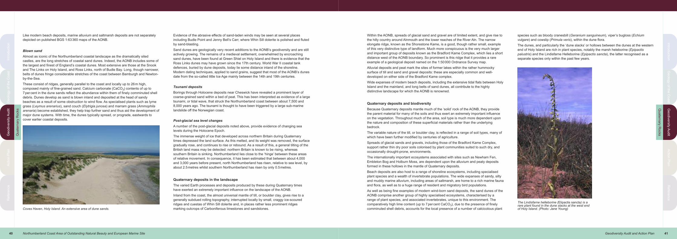
41Geodiversity Audit and Action Plan
Intro
du
ctio
nG
eo
log
y o
f the
Co
ast
Ge
od
ive
rsity
Au
dit
Actio
n P
lan
Re
fere
nce
Intr
od
uctio
nG
eo
log
y o
f th
e C
oa
st
Ge
od
ive
rsity A
ud
itA
ctio
n P
lan
Re
fere
nce
40 Northumberland Coast Area of Outstanding Natural Beauty and European Marine Site
Like modern beach deposits, marine alluvium and saltmarsh deposits are not separately
depicted on published BGS 1:63360 maps of the AONB.
Blown sand
Almost as iconic of the Northumberland coastal landscape as the dramatically sited
castles, are the long stretches of coastal sand dunes. Indeed, the AONB includes some of
the largest and finest of England’s coastal dunes. Most extensive are those at the Snook
and The Links on Holy Island, and Ross Links, north of Budle Bay. Long, though narrower,
belts of dunes fringe considerable stretches of the coast between Bamburgh and Newton-
by-the-Sea.
These consist of ridges, generally parallel to the coast and locally up to 26m high,
composed mainly of fine-grained sand. Calcium carbonate (CaCO3) contents of up to
7percent in the dune sands reflect the abundance within them of finely comminuted shell
debris. Dunes develop as sand is blown inland and deposited at the head of sandy
beaches as a result of some obstruction to wind flow. As specialised plants such as lyme
grass (Leymus arenarius), sand couch (Elytrigia juncea) and marram grass (Ammophila
arenaria) become established, they help trap further sand and thus aid the development of
major dune systems. With time, the dunes typically spread, or prograde, eastwards to
cover earlier coastal deposits.
Evidence of the abrasive effects of sand-laden winds may be seen at several places
including Budle Point and Jenny Bell’s Carr, where Whin Sill dolerite is polished and fluted
by sand-blasting.
Sand dunes are geologically very recent additions to the AONB’s geodiversity and are still
actively growing. The remains of a medieval settlement, overwhelmed by encroaching
sand dunes, have been found at Green Shiel on Holy Island and there is evidence that the
Ross Links dunes may have grown since the 17th century. World War II coastal tank
defences, buried by dune deposits, today lie some distance inland of the shoreline.
Modern dating techniques, applied to sand grains, suggest that most of the AONB’s dunes
date from the so-called little Ice Age mainly between the 14th and 19th centuries.
Tsunami deposits
Borings through Holocene deposits near Cheswick have revealed a prominent layer of
coarse-grained sand within a bed of peat. This has been interpreted as evidence of a large
tsunami, or tidal wave, that struck the Northumberland coast between about 7,500 and
8,000 years ago. The tsunami is thought to have been triggered by a large sub-marine
landslide off the Norwegian coast.
Post-glacial sea level changes
A number of the post-glacial deposits noted above, provide evidence of changing sea
levels during the Holocene Epoch.
The immense weight of ice that developed across northern Britain during Quaternary
times depressed the land surface. As this melted, and its weight was removed, the surface
gradually rose, and continues to rise or rebound. As a result of this, a general tilting of the
British land mass may be detected: northern Britain is known to be rising, whereas
southern Britain is sinking. Northumberland lies close to the ‘hinge’ between these areas
of relative movement. In consequence, it has been estimated that between about 4,000
and 3,000 years before present, north Northumberland has risen, relative to sea level, by
about 2.5metres whilst southern Northumberland has risen by only 0.5metres.
Quaternary deposits in the landscape
The varied Earth processes and deposits produced by these during Quaternary times
have exerted an extremely important influence on the landscape of the AONB.
Inland from the coast, the almost universal mantle of till, or boulder clay, gives rise to a
generally subdued rolling topography, interrupted locally by small, craggy ice-scoured
ridges and cuestas of Whin Sill dolerite and, in places rather less prominent ridges
marking outcrops of Carboniferous limestones and sandstones.
Within the AONB, spreads of glacial sand and gravel are of limited extent, and give rise to
the hilly country around Alnmouth and the lower reaches of the River Aln. The narrow
elongate ridge, known as the Shorestone Kame, is a good, though rather small, example
of this very distinctive type of landform. Much more conspicuous is the very much larger
and important group of deposits known as the Bradford Kame Complex, which lies a short
distance west of the AONB boundary. So prominent is this ridge that it provides a rare
example of a geological deposit named on the 1:50000 Ordnance Survey map.
Alluvial deposits and peat mark the sites of former lakes within the rather hummocky
surface of till and sand and gravel deposits: these are especially common and well-
developed on either side of the Bradford Kame complex.
Wide expanses of modern beach deposits, including the extensive tidal flats between Holy
Island and the mainland, and long belts of sand dunes, all contribute to the highly
distinctive landscape for which the AONB is renowned.
Quaternary deposits and biodiversity
Because Quaternary deposits mantle much of the ‘solid’ rock of the AONB, they provide
the parent material for many of the soils and thus exert an extremely important influence
on the vegetation. Throughout much of the area, soil type is much more dependent upon
the nature and composition of these superficial materials rather than the underlying
bedrock.
The variable nature of the till, or boulder clay, is reflected in a range of soil types, many of
which have been further modified by centuries of agriculture.
Spreads of glacial sands and gravels, including those of the Bradford Kame Complex,
support rather thin dry poor soils colonised by plant communities suited to such dry, and
occasionally drought-prone, environments.
The internationally important ecosystems associated with sites such as Newham Fen,
Embleton Bog and Holburn Moss, are dependent upon the alluvium and peaty deposits
formed in these hollows in the mantle of Quaternary deposits.
Beach deposits are also host to a range of shoreline ecosystems, including specialised
plant species and a wealth of invertebrate populations. The wide expanses of sandy, silty
and muddy marine alluvium, including areas of saltmarsh, are home to a rich marine fauna
and flora, as well as to a huge range of resident and migratory bird populations.
As well as being fine examples of modern wind-born sand deposits, the sand dunes of the
AONB comprise another group of highly specialised ecosystems, characterised by a
range of plant species, and associated invertebrates, unique to this environment. The
comparatively high lime content (up to 7percent CaCO3), due to the presence of finely
comminuted shell debris, accounts for the local presence of a number of calcicolous plant
species such as bloody cranesbill (Geranium sanguineum), viper’s bugloss (Echium
vulgare) and cowslip (Primula veris), within the dune flora.
The dunes, and particularly the ‘dune slacks’ or hollows between the dunes at the western
end of Holy Island are rich in plant species, notably the marsh heleborine (Epipactis
palustris) and the Lindisfarne Helleborine (Epipactis sancta), the latter recognised as a
separate species only within the past few years.
Coves Haven, Holy Island. An extensive area of dune sands.
The Lindisfarne helleborine (Elipactis sancta) is arare plant found in the dune slacks at the west endof Holy Island. (Photo: Jane Young)
Qu
ate
rna
ry R
ocks
Qu
ate
rna
ry R
ocks
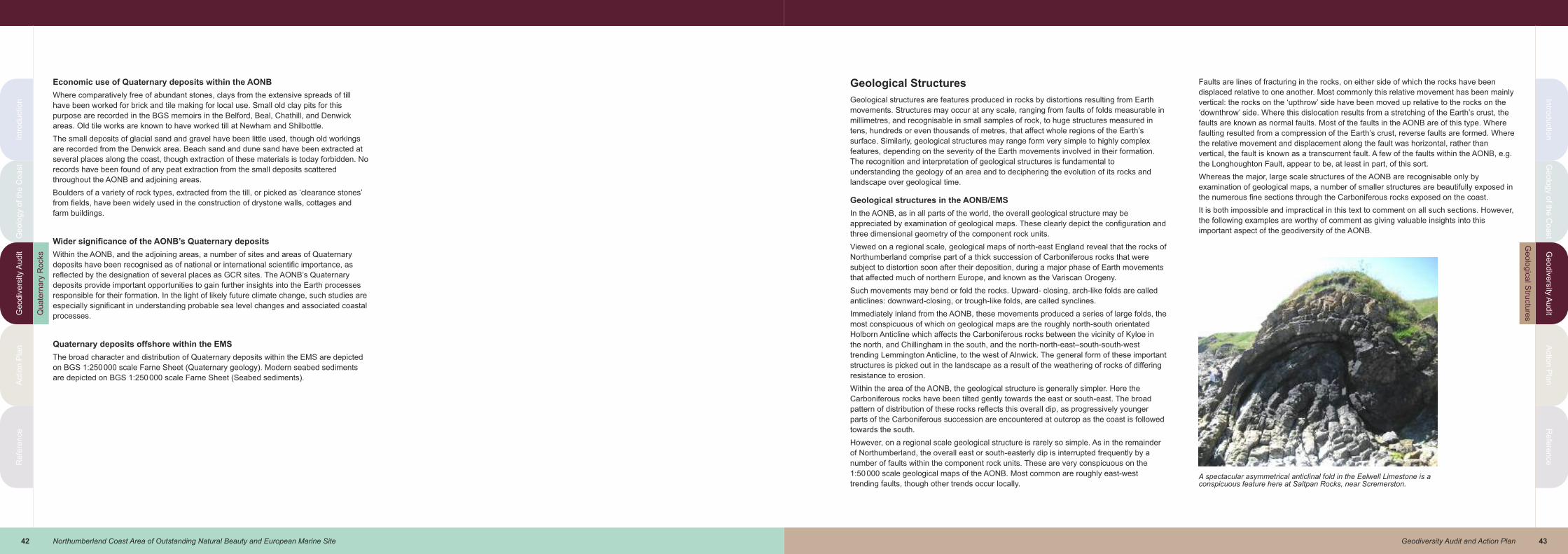
43Geodiversity Audit and Action Plan
Intro
du
ctio
nG
eo
log
y o
f the
Co
ast
Ge
od
ive
rsity
Au
dit
Actio
n P
lan
Re
fere
nce
Intr
od
uctio
nG
eo
log
y o
f th
e C
oa
st
Ge
od
ive
rsity A
ud
itA
ctio
n P
lan
Re
fere
nce
42 Northumberland Coast Area of Outstanding Natural Beauty and European Marine Site
Economic use of Quaternary deposits within the AONB
Where comparatively free of abundant stones, clays from the extensive spreads of till
have been worked for brick and tile making for local use. Small old clay pits for this
purpose are recorded in the BGS memoirs in the Belford, Beal, Chathill, and Denwick
areas. Old tile works are known to have worked till at Newham and Shilbottle.
The small deposits of glacial sand and gravel have been little used, though old workings
are recorded from the Denwick area. Beach sand and dune sand have been extracted at
several places along the coast, though extraction of these materials is today forbidden. No
records have been found of any peat extraction from the small deposits scattered
throughout the AONB and adjoining areas.
Boulders of a variety of rock types, extracted from the till, or picked as ‘clearance stones’
from fields, have been widely used in the construction of drystone walls, cottages and
farm buildings.
Wider significance of the AONB’s Quaternary deposits
Within the AONB, and the adjoining areas, a number of sites and areas of Quaternary
deposits have been recognised as of national or international scientific importance, as
reflected by the designation of several places as GCR sites. The AONB’s Quaternary
deposits provide important opportunities to gain further insights into the Earth processes
responsible for their formation. In the light of likely future climate change, such studies are
especially significant in understanding probable sea level changes and associated coastal
processes.
Quaternary deposits offshore within the EMS
The broad character and distribution of Quaternary deposits within the EMS are depicted
on BGS 1:250000 scale Farne Sheet (Quaternary geology). Modern seabed sediments
are depicted on BGS 1:250000 scale Farne Sheet (Seabed sediments).
Geological Structures
Geological structures are features produced in rocks by distortions resulting from Earth
movements. Structures may occur at any scale, ranging from faults of folds measurable in
millimetres, and recognisable in small samples of rock, to huge structures measured in
tens, hundreds or even thousands of metres, that affect whole regions of the Earth’s
surface. Similarly, geological structures may range form very simple to highly complex
features, depending on the severity of the Earth movements involved in their formation.
The recognition and interpretation of geological structures is fundamental to
understanding the geology of an area and to deciphering the evolution of its rocks and
landscape over geological time.
Geological structures in the AONB/EMS
In the AONB, as in all parts of the world, the overall geological structure may be
appreciated by examination of geological maps. These clearly depict the configuration and
three dimensional geometry of the component rock units.
Viewed on a regional scale, geological maps of north-east England reveal that the rocks of
Northumberland comprise part of a thick succession of Carboniferous rocks that were
subject to distortion soon after their deposition, during a major phase of Earth movements
that affected much of northern Europe, and known as the Variscan Orogeny.
Such movements may bend or fold the rocks. Upward- closing, arch-like folds are called
anticlines: downward-closing, or trough-like folds, are called synclines.
Immediately inland from the AONB, these movements produced a series of large folds, the
most conspicuous of which on geological maps are the roughly north-south orientated
Holborn Anticline which affects the Carboniferous rocks between the vicinity of Kyloe in
the north, and Chillingham in the south, and the north-north-east–south-south-west
trending Lemmington Anticline, to the west of Alnwick. The general form of these important
structures is picked out in the landscape as a result of the weathering of rocks of differing
resistance to erosion.
Within the area of the AONB, the geological structure is generally simpler. Here the
Carboniferous rocks have been tilted gently towards the east or south-east. The broad
pattern of distribution of these rocks reflects this overall dip, as progressively younger
parts of the Carboniferous succession are encountered at outcrop as the coast is followed
towards the south.
However, on a regional scale geological structure is rarely so simple. As in the remainder
of Northumberland, the overall east or south-easterly dip is interrupted frequently by a
number of faults within the component rock units. These are very conspicuous on the
1:50000 scale geological maps of the AONB. Most common are roughly east-west
trending faults, though other trends occur locally.
Faults are lines of fracturing in the rocks, on either side of which the rocks have been
displaced relative to one another. Most commonly this relative movement has been mainly
vertical: the rocks on the ‘upthrow’ side have been moved up relative to the rocks on the
‘downthrow’ side. Where this dislocation results from a stretching of the Earth’s crust, the
faults are known as normal faults. Most of the faults in the AONB are of this type. Where
faulting resulted from a compression of the Earth’s crust, reverse faults are formed. Where
the relative movement and displacement along the fault was horizontal, rather than
vertical, the fault is known as a transcurrent fault. A few of the faults within the AONB, e.g.
the Longhoughton Fault, appear to be, at least in part, of this sort.
Whereas the major, large scale structures of the AONB are recognisable only by
examination of geological maps, a number of smaller structures are beautifully exposed in
the numerous fine sections through the Carboniferous rocks exposed on the coast.
It is both impossible and impractical in this text to comment on all such sections. However,
the following examples are worthy of comment as giving valuable insights into this
important aspect of the geodiversity of the AONB.
A spectacular asymmetrical anticlinal fold in the Eelwell Limestone is aconspicuous feature here at Saltpan Rocks, near Scremerston.
Qu
ate
rna
ry R
ocks
Ge
olo
gic
al S
tructu
res
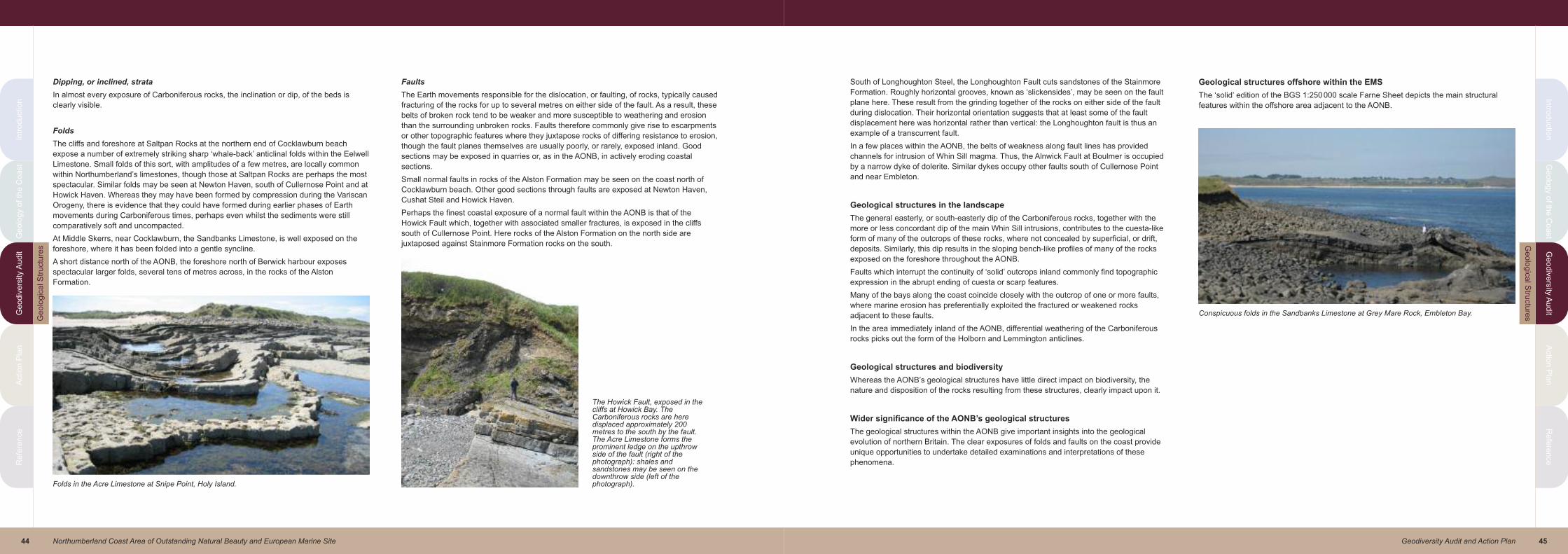
45Geodiversity Audit and Action Plan
Intro
du
ctio
nG
eo
log
y o
f the
Co
ast
Ge
od
ive
rsity
Au
dit
Actio
n P
lan
Re
fere
nce
Intr
od
uctio
nG
eo
log
y o
f th
e C
oa
st
Ge
od
ive
rsity A
ud
itA
ctio
n P
lan
Re
fere
nce
44 Northumberland Coast Area of Outstanding Natural Beauty and European Marine Site
Dipping, or inclined, strata
In almost every exposure of Carboniferous rocks, the inclination or dip, of the beds is
clearly visible.
Folds
The cliffs and foreshore at Saltpan Rocks at the northern end of Cocklawburn beach
expose a number of extremely striking sharp ‘whale-back’ anticlinal folds within the Eelwell
Limestone. Small folds of this sort, with amplitudes of a few metres, are locally common
within Northumberland’s limestones, though those at Saltpan Rocks are perhaps the most
spectacular. Similar folds may be seen at Newton Haven, south of Cullernose Point and at
Howick Haven. Whereas they may have been formed by compression during the Variscan
Orogeny, there is evidence that they could have formed during earlier phases of Earth
movements during Carboniferous times, perhaps even whilst the sediments were still
comparatively soft and uncompacted.
At Middle Skerrs, near Cocklawburn, the Sandbanks Limestone, is well exposed on the
foreshore, where it has been folded into a gentle syncline.
A short distance north of the AONB, the foreshore north of Berwick harbour exposes
spectacular larger folds, several tens of metres across, in the rocks of the Alston
Formation.
Faults
The Earth movements responsible for the dislocation, or faulting, of rocks, typically caused
fracturing of the rocks for up to several metres on either side of the fault. As a result, these
belts of broken rock tend to be weaker and more susceptible to weathering and erosion
than the surrounding unbroken rocks. Faults therefore commonly give rise to escarpments
or other topographic features where they juxtapose rocks of differing resistance to erosion,
though the fault planes themselves are usually poorly, or rarely, exposed inland. Good
sections may be exposed in quarries or, as in the AONB, in actively eroding coastal
sections.
Small normal faults in rocks of the Alston Formation may be seen on the coast north of
Cocklawburn beach. Other good sections through faults are exposed at Newton Haven,
Cushat Steil and Howick Haven.
Perhaps the finest coastal exposure of a normal fault within the AONB is that of the
Howick Fault which, together with associated smaller fractures, is exposed in the cliffs
south of Cullernose Point. Here rocks of the Alston Formation on the north side are
juxtaposed against Stainmore Formation rocks on the south.
South of Longhoughton Steel, the Longhoughton Fault cuts sandstones of the Stainmore
Formation. Roughly horizontal grooves, known as ‘slickensides’, may be seen on the fault
plane here. These result from the grinding together of the rocks on either side of the fault
during dislocation. Their horizontal orientation suggests that at least some of the fault
displacement here was horizontal rather than vertical: the Longhoughton fault is thus an
example of a transcurrent fault.
In a few places within the AONB, the belts of weakness along fault lines has provided
channels for intrusion of Whin Sill magma. Thus, the Alnwick Fault at Boulmer is occupied
by a narrow dyke of dolerite. Similar dykes occupy other faults south of Cullernose Point
and near Embleton.
Geological structures in the landscape
The general easterly, or south-easterly dip of the Carboniferous rocks, together with the
more or less concordant dip of the main Whin Sill intrusions, contributes to the cuesta-like
form of many of the outcrops of these rocks, where not concealed by superficial, or drift,
deposits. Similarly, this dip results in the sloping bench-like profiles of many of the rocks
exposed on the foreshore throughout the AONB.
Faults which interrupt the continuity of ‘solid’ outcrops inland commonly find topographic
expression in the abrupt ending of cuesta or scarp features.
Many of the bays along the coast coincide closely with the outcrop of one or more faults,
where marine erosion has preferentially exploited the fractured or weakened rocks
adjacent to these faults.
In the area immediately inland of the AONB, differential weathering of the Carboniferous
rocks picks out the form of the Holborn and Lemmington anticlines.
Geological structures and biodiversity
Whereas the AONB’s geological structures have little direct impact on biodiversity, the
nature and disposition of the rocks resulting from these structures, clearly impact upon it.
Wider significance of the AONB’s geological structures
The geological structures within the AONB give important insights into the geological
evolution of northern Britain. The clear exposures of folds and faults on the coast provide
unique opportunities to undertake detailed examinations and interpretations of these
phenomena.
Geological structures offshore within the EMS
The ‘solid’ edition of the BGS 1:250000 scale Farne Sheet depicts the main structural
features within the offshore area adjacent to the AONB.
Folds in the Acre Limestone at Snipe Point, Holy Island.
The Howick Fault, exposed in thecliffs at Howick Bay. TheCarboniferous rocks are heredisplaced approximately 200metres to the south by the fault.The Acre Limestone forms theprominent ledge on the upthrowside of the fault (right of thephotograph): shales andsandstones may be seen on thedownthrow side (left of thephotograph).
Conspicuous folds in the Sandbanks Limestone at Grey Mare Rock, Embleton Bay.
Ge
olo
gic
al S
tru
ctu
res
Ge
olo
gic
al S
tructu
res
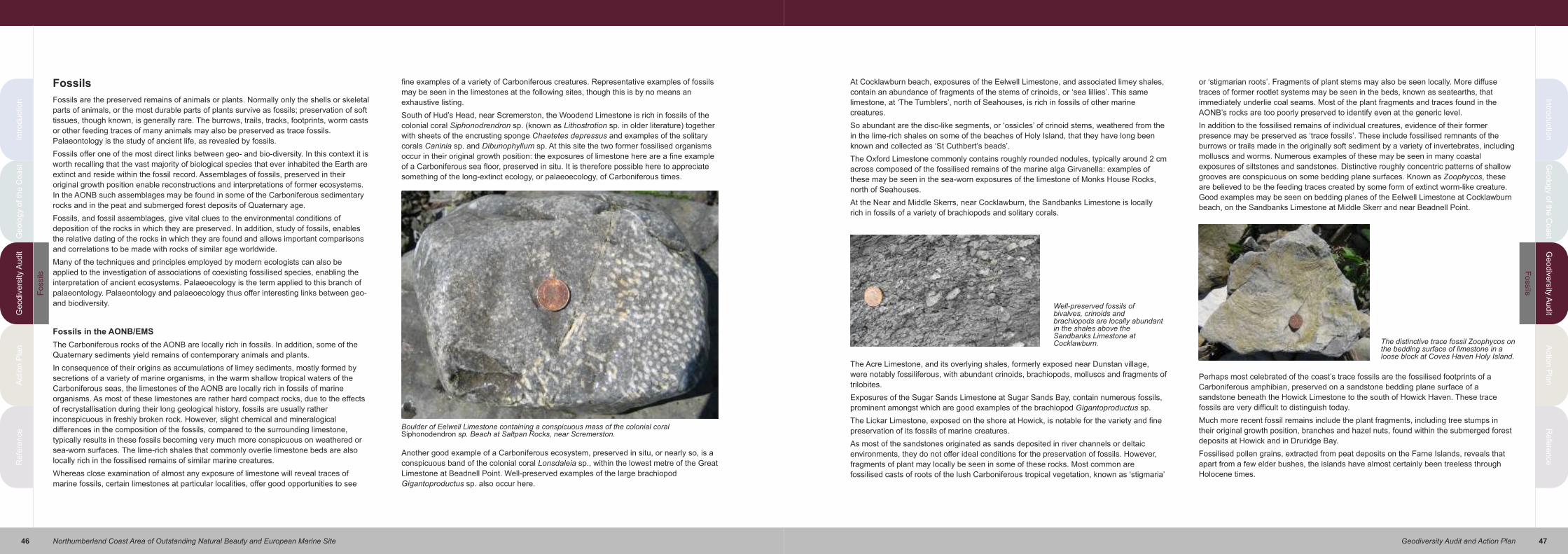
47Geodiversity Audit and Action Plan
Intro
du
ctio
nG
eo
log
y o
f the
Co
ast
Ge
od
ive
rsity
Au
dit
Actio
n P
lan
Re
fere
nce
Intr
od
uctio
nG
eo
log
y o
f th
e C
oa
st
Ge
od
ive
rsity A
ud
itA
ctio
n P
lan
Re
fere
nce
46 Northumberland Coast Area of Outstanding Natural Beauty and European Marine Site
Fossils
Fossils are the preserved remains of animals or plants. Normally only the shells or skeletal
parts of animals, or the most durable parts of plants survive as fossils; preservation of soft
tissues, though known, is generally rare. The burrows, trails, tracks, footprints, worm casts
or other feeding traces of many animals may also be preserved as trace fossils.
Palaeontology is the study of ancient life, as revealed by fossils.
Fossils offer one of the most direct links between geo- and bio-diversity. In this context it is
worth recalling that the vast majority of biological species that ever inhabited the Earth are
extinct and reside within the fossil record. Assemblages of fossils, preserved in their
original growth position enable reconstructions and interpretations of former ecosystems.
In the AONB such assemblages may be found in some of the Carboniferous sedimentary
rocks and in the peat and submerged forest deposits of Quaternary age.
Fossils, and fossil assemblages, give vital clues to the environmental conditions of
deposition of the rocks in which they are preserved. In addition, study of fossils, enables
the relative dating of the rocks in which they are found and allows important comparisons
and correlations to be made with rocks of similar age worldwide.
Many of the techniques and principles employed by modern ecologists can also be
applied to the investigation of associations of coexisting fossilised species, enabling the
interpretation of ancient ecosystems. Palaeoecology is the term applied to this branch of
palaeontology. Palaeontology and palaeoecology thus offer interesting links between geo-
and biodiversity.
Fossils in the AONB/EMS
The Carboniferous rocks of the AONB are locally rich in fossils. In addition, some of the
Quaternary sediments yield remains of contemporary animals and plants.
In consequence of their origins as accumulations of limey sediments, mostly formed by
secretions of a variety of marine organisms, in the warm shallow tropical waters of the
Carboniferous seas, the limestones of the AONB are locally rich in fossils of marine
organisms. As most of these limestones are rather hard compact rocks, due to the effects
of recrystallisation during their long geological history, fossils are usually rather
inconspicuous in freshly broken rock. However, slight chemical and mineralogical
differences in the composition of the fossils, compared to the surrounding limestone,
typically results in these fossils becoming very much more conspicuous on weathered or
sea-worn surfaces. The lime-rich shales that commonly overlie limestone beds are also
locally rich in the fossilised remains of similar marine creatures.
Whereas close examination of almost any exposure of limestone will reveal traces of
marine fossils, certain limestones at particular localities, offer good opportunities to see
fine examples of a variety of Carboniferous creatures. Representative examples of fossils
may be seen in the limestones at the following sites, though this is by no means an
exhaustive listing.
South of Hud’s Head, near Scremerston, the Woodend Limestone is rich in fossils of the
colonial coral Siphonodrendron sp. (known as Lithostrotion sp. in older literature) together
with sheets of the encrusting sponge Chaetetes depressus and examples of the solitary
corals Caninia sp. and Dibunophyllum sp. At this site the two former fossilised organisms
occur in their original growth position: the exposures of limestone here are a fine example
of a Carboniferous sea floor, preserved in situ. It is therefore possible here to appreciate
something of the long-extinct ecology, or palaeoecology, of Carboniferous times.
Another good example of a Carboniferous ecosystem, preserved in situ, or nearly so, is a
conspicuous band of the colonial coral Lonsdaleia sp., within the lowest metre of the Great
Limestone at Beadnell Point. Well-preserved examples of the large brachiopod
Gigantoproductus sp. also occur here.
At Cocklawburn beach, exposures of the Eelwell Limestone, and associated limey shales,
contain an abundance of fragments of the stems of crinoids, or ‘sea lillies’. This same
limestone, at ‘The Tumblers’, north of Seahouses, is rich in fossils of other marine
creatures.
So abundant are the disc-like segments, or ‘ossicles’ of crinoid stems, weathered from the
in the lime-rich shales on some of the beaches of Holy Island, that they have long been
known and collected as ‘St Cuthbert’s beads’.
The Oxford Limestone commonly contains roughly rounded nodules, typically around 2 cm
across composed of the fossilised remains of the marine alga Girvanella: examples of
these may be seen in the sea-worn exposures of the limestone of Monks House Rocks,
north of Seahouses.
At the Near and Middle Skerrs, near Cocklawburn, the Sandbanks Limestone is locally
rich in fossils of a variety of brachiopods and solitary corals.
The Acre Limestone, and its overlying shales, formerly exposed near Dunstan village,
were notably fossiliferous, with abundant crinoids, brachiopods, molluscs and fragments of
trilobites.
Exposures of the Sugar Sands Limestone at Sugar Sands Bay, contain numerous fossils,
prominent amongst which are good examples of the brachiopod Gigantoproductus sp.
The Lickar Limestone, exposed on the shore at Howick, is notable for the variety and fine
preservation of its fossils of marine creatures.
As most of the sandstones originated as sands deposited in river channels or deltaic
environments, they do not offer ideal conditions for the preservation of fossils. However,
fragments of plant may locally be seen in some of these rocks. Most common are
fossilised casts of roots of the lush Carboniferous tropical vegetation, known as ‘stigmaria’
or ‘stigmarian roots’. Fragments of plant stems may also be seen locally. More diffuse
traces of former rootlet systems may be seen in the beds, known as seatearths, that
immediately underlie coal seams. Most of the plant fragments and traces found in the
AONB’s rocks are too poorly preserved to identify even at the generic level.
In addition to the fossilised remains of individual creatures, evidence of their former
presence may be preserved as ‘trace fossils’. These include fossilised remnants of the
burrows or trails made in the originally soft sediment by a variety of invertebrates, including
molluscs and worms. Numerous examples of these may be seen in many coastal
exposures of siltstones and sandstones. Distinctive roughly concentric patterns of shallow
grooves are conspicuous on some bedding plane surfaces. Known as Zoophycos, these
are believed to be the feeding traces created by some form of extinct worm-like creature.
Good examples may be seen on bedding planes of the Eelwell Limestone at Cocklawburn
beach, on the Sandbanks Limestone at Middle Skerr and near Beadnell Point.
Perhaps most celebrated of the coast’s trace fossils are the fossilised footprints of a
Carboniferous amphibian, preserved on a sandstone bedding plane surface of a
sandstone beneath the Howick Limestone to the south of Howick Haven. These trace
fossils are very difficult to distinguish today.
Much more recent fossil remains include the plant fragments, including tree stumps in
their original growth position, branches and hazel nuts, found within the submerged forest
deposits at Howick and in Druridge Bay.
Fossilised pollen grains, extracted from peat deposits on the Farne Islands, reveals that
apart from a few elder bushes, the islands have almost certainly been treeless through
Holocene times.
Boulder of Eelwell Limestone containing a conspicuous mass of the colonial coralSiphonodendron sp. Beach at Saltpan Rocks, near Scremerston.
Well-preserved fossils ofbivalves, crinoids andbrachiopods are locally abundantin the shales above theSandbanks Limestone atCocklawburn. The distinctive trace fossil Zoophycos on
the bedding surface of limestone in aloose block at Coves Haven Holy Island.
Fo
ssils
Fo
ssils

49Geodiversity Audit and Action Plan
Intro
du
ctio
nG
eo
log
y o
f the
Co
ast
Ge
od
ive
rsity
Au
dit
Actio
n P
lan
Re
fere
nce
Intr
od
uctio
nG
eo
log
y o
f th
e C
oa
st
Ge
od
ive
rsity A
ud
itA
ctio
n P
lan
Re
fere
nce
48 Northumberland Coast Area of Outstanding Natural Beauty and European Marine Site
Minerals
A mineral is defined as “A substance having a definite, but not fixed, chemical composition
and atomic structure and normally formed by the inorganic processes of nature”. Individual
minerals are referred to as species. The study of minerals is called mineralogy. As rocks
are composed of different minerals in varying proportions, minerals may be regarded as
the essential components of those rocks. Outside of the Earth sciences, the term ‘mineral’
is commonly used to denote any natural product obtained from the Earth. Thus, although it
is common to regard coal, oil, gas, limestone, ‘whinstone’, peat etc as mineral products,
they do not fulfil the strict definition of a mineral. This section of the document is
concerned with minerals, as they are defined above.
Minerals within the AONB/EMS
Individual mineral species are the essential components of rocks. Brief comments on the
mineralogical composition of the AONB’s rocks and sediments are given in appropriate
sections of this document and will not be discussed further here. Minerals may also occur
alone, or in associations, in a variety of other geological environments. Within the AONB,
these occurrences include mineral veins – narrow vertical bodies that cut pre-existing
rocks as cavity fillings within the Whin Sill, and as pebbles on modern beaches. Each of
these will be reviewed briefly below:
Mineral veins
Because of their geological setting, the rocks of the AONB lie well beyond the
concentrations of mineral veins that comprise important elements in the geodiversity of
south Northumberland, most notably in the Northern Pennines and Tyne Gap. However, a
number of veins are present, though they are little known.
Galena (PbS), the main ore of lead, has been recorded from small veins found in a small
coal working near Rock Hall, on the foreshore at Beadnell, on the coast at Ellwick, on the
east side of Holy Island, in the Lowick area, in the fault exposed in the cliffs at Howick,
associated with marcasite at Little Houghton, and in underground workings in Shilbottle
Colliery, a little way to the south of the AONB. Apart from unsuccessful attempts to work
the first two of these, no attempts at exploitation are known. None is known to be exposed
today and the writers are unaware of the existence of any specimens of ore from these
occurrences.
Near Harkess Rocks, the Whin Sill contains a few veins, up to a few centimetres wide,
containing baryte, calcite and pyrite. Narrow veins of calcite, locally accompanied by
dolomite, occur in some of the limestones, for example at Salt Pan Rocks and at Grey
Mare Rocks.
At Cragmill Quarry quartz veins up to about 2cm wide have been noted, with sprays of
dark brown goethite crystals, apparently associated with the metamorphism of the
ironstone nodules, described previously in the section on Metamorphic rocks.
Cavity fillings
Gas cavities, or vesicles, within the Whin Sill, mentioned above, are commonly partially or
wholly filled with minerals and are then referred to as amygdales. Most common of the
introduced minerals are calcite and quartz. Well-formed colourless crystals of quartz have
long been known as ‘Dunstanburgh diamonds’. Also present are quartz crystals of a
purple colour, giving the variety known as ‘amethyst’.
Nodules within Shales
The unusual occurrence of galena, accompanied by the zinc sulphide mineral sphalerite
((Zn,Fe)S), of sedimentary origin, in nodules scattered through Carboniferous shales, has
been noted in the section on Carboniferous rocks.
Weathering products
Vivid yellow crystalline crusts of iron sulphate minerals including copiapite, resulting from
the weathering of pyrite–rich coal, are locally conspicuous on weathered exposures of
some coal seams, for example in Howick Bay and at Salt Pan Rocks.
Beach pebbles
The local boulder clay, or till, commonly contains erratic blocks of rocks derived from the
Cheviots. Small, but often beautifully patterned, agates from the Cheviot lavas, winnowed
by the sea from these deposits, are locally common on some beaches.
Economic use of minerals
Despite brief records of attempts to explore the economic potential of lead ore at Rock
Hall and Beadnell foreshore, there has never been commercial working of these or any
other lead ore occurrences in and adjacent to the AONB.
Wider significance of the AONB’s minerals
Irrespective of their uneconomic scale, the scattered occurrences of lead ore have hitherto
attracted surprisingly little scientific interest. With modern analytical techniques, they may
be of interest in offering useful insights into the role of the thick succession of
Carboniferous sediments of the Northumberland-Solway trough as a potential source of
ore-forming fluids, in the mineralization of the Northern Pennine Orefield.
Calcite fills amygdales in the Whin Sill dolerite at Harkess Rocks, near Bamburgh.
Bright yellow coatings of the iron sulphate mineral copiapite, formed by alteration of the mineralpyrite, may be seen in dry weather on surfaces of coal seams as here at Howick Bay.
Small agates collected from the shingle at Cocklawburn Beach. Agates arelocally common in the lavas of the Cheviot Hills and may be found on many ofNorthumberland’s beaches whence they have been carried by ice sheets duringthe last glacial period.
Min
era
lsM
ine
rals

51Geodiversity Audit and Action Plan
Intro
du
ctio
nG
eo
log
y o
f the
Co
ast
Ge
od
ive
rsity
Au
dit
Actio
n P
lan
Re
fere
nce
Intr
od
uctio
nG
eo
log
y o
f th
e C
oa
st
Ge
od
ive
rsity A
ud
itA
ctio
n P
lan
Re
fere
nce
50 Northumberland Coast Area of Outstanding Natural Beauty and European Marine Site
Mineral Extraction
It is clear from the definition of geodiversity, quoted in the introduction to this document,
that an area’s geodiversity embraces not only the geological materials and the processes
that formed them, but the materials and products that have been extracted as raw
materials.
A variety of mineral products has been worked in the AONB in the past. As the extraction
of most of these has left some legacy on today’s landscape and environment, these must
be considered as vital elements within the AONB’s geodiversity. Although no form of
mineral extraction is active within the AONB today, two substantial quarries are still
operating within a few kilometres of its western boundary.
Brief comments follow on the mineral products known to have been worked within the
AONB, or within the immediately adjoining areas.
Coal
Numerous coal seams occur within the Carboniferous rocks of the AONB. Whereas many
of these are too thin or of too poor quality to have been of economic interest, a significant
number have been worked. Within the AONB most of the workings were comparatively
small and supplied local needs, mainly for domestic use and for lime burning. However, a
few seams in the areas immediately adjoining the AONB were worked on a more
substantial scale, in some instances supplying coal to a wide area of Northumberland and
beyond.
The greatest concentration of coal seams in this part of Northumberland occurs within the
succession of rocks formerly known as the Scremerston Coal Group, now included within
the Tyne Limestone Formation. As might be expected, these rocks take their name from
the village of Scremerston, a short distance north of the AONB. Several seams crop out
on the coast here where they were originally discovered and probably first worked. As the
most easily won coal was exhausted from these outcrops, the seams were followed inland
from a number of underground collieries. The partially collapsed remains of old mine
entrances and drainage adits can be seen near Hud’s Head.
Further south, a number of seams were worked from shallow shafts on Holy Island, in the
Kyloe, Fenwick, Belford, Seahouses, Beadnell, Embleton and Howick areas. These seams
were locally up to 0.6metres thick, though many were much thinner. The positions of many
of the shafts are indicated on the 1:50000 scale geological maps. A number of seams are
still exposed on the shore and in the cliffs around Sea Houses and Beadnell.
The most significant coal deposits within the neighbourhood of the AONB, and the most
recently worked, are those of the Shilbottle seam within the rocks of the Carboniferous
Alston Formation. This seam was locally up to 0.7metres thick. Underground workings in
this seam approach the AONB near Lesbury and High Buston. The most recent workings
here, at Shilbottle Colliery, closed in 1982.
Limestone
Numerous beds of limestone occur within the Carboniferous rocks of the AONB. Whereas
many of these are comparatively thin, commonly less than 2.5metres thick, several were
thicker and were exploited on a considerable scale for the making of burnt lime, or quick
lime. This had two main uses locally. Firstly, when hydrated with water, to produce slaked
or hydrated lime, it was used as a soil improver to sweeten acidic soils. Secondly,
substantial quantities of lime were used in making lime mortar, an essential building
material before the widespread use of Portland cement.
Many of the AONB’s limestones have been worked in small quarries, often for small scale
local use. Larger quarries, with attached limekilns, were worked at Cocklawburn, Holy
Island, Seahouses, Beadnell and Littlemill. Ruined limekilns remain at many of these sites,
adjacent to the long-abandoned quarries. At some of these locations, e.g. Cocklawburn
and Littlemill, burnt lime was transported from the area via the main east coast railway.
The kilns on the harbourside at Beadnell served an important coastal trade in burnt lime.
Sandstone
Sandstones comprise a substantial proportion of the AONB’s succession of Carboniferous
rocks. Many of these have been employed as local building stones, though the high
quality sandstone formerly quarried at Denwick, was employed widely across northern
England and southern Scotland.
‘Whinstone’
Whin Sill dolerite, more commonly known in Northumberland as ‘whinstone’, provides an
excellent roadstone and has been quarried from many of its outcrops in the AONB. The
industry reached its peak production during the 19th and early 20th centuries, producing
both chippings and setts. Quarries which were worked around Bamburgh, Embleton,
Craster and Howick remain conspicuous landscape features today. At Craster ‘whinstone’
chippings, produced in the quarry which is now the village car park, were carried by aerial
ropeway to large hoppers on the pier from which they were loaded into steamers: the
foundations of these hoppers remain prominent features of Craster harbour today. None of
the quarries within the AONB is active today, though large quarries are still working at
Belford and Howick a short distance to the west.
Whereas Whin Sill dolerite has not been widely employed as a building stone elsewhere in
Northumberland, it has been much used in Bamburgh, Craster and Embleton where it
gives a distinctive character to the cottages built from it.
The Acre Coal, a thin coal seam exposed in the cliffs at Saltpan Rocks, near Scremerston.
Old flooded quarries in the Eelwell Limestone at Seahouses Golf Course.
Beadnell limekilns, once the centre of an important coastal trade in lime.
The main car park at Craster is sited within the former whinstone quarry, the faces of which arenow seriously overgrown.
Min
era
l E
xtr
actio
nM
ine
ral E
xtra
ctio
n

53Geodiversity Audit and Action Plan
Intro
du
ctio
nG
eo
log
y o
f the
Co
ast
Ge
od
ive
rsity
Au
dit
Actio
n P
lan
Re
fere
nce
Intr
od
uctio
nG
eo
log
y o
f th
e C
oa
st
Ge
od
ive
rsity A
ud
itA
ctio
n P
lan
Re
fere
nce
52 Northumberland Coast Area of Outstanding Natural Beauty and European Marine Site
Iron ore
Rounded nodules of clay ironstone, composed mainly of fine-grained concentrations of the
iron carbonate mineral siderite
(FeCO3), are common in several
of the shale units within the
AONB’s Carboniferous rocks.
Large examples of these, from
shales above the Acre Limestone
on Holy Island, were collected
from the beaches and exported to
Scotland as iron ores in the late
18th century.
Fragments of iron slag, found on
the shore at Cocklawburn, suggest
that some early small-scale iron
smelting may have taken place
here, no doubt exploiting ironstone
nodules from the Carboniferous
shales exposed nearby.
Lead ore
The occurrence of narrow veins of the lead ore mineral, galena, in and near the AONB has
been mentioned above. Apart from unsuccessful attempts to work the veins at Rock Hall
and Beadnell no attempts at exploitation are known.
Sand and gravel
The small deposits of glacial sand and gravel have been little used, though old workings
are recorded from the Denwick area. Small quantities of sand have been dug from time to
time from beaches and sand dunes.
Brick clay
Where comparatively free of abundant stones, clays from the extensive spreads of till
have been worked for brick and tile making for local use. Small old clay pits for this
purpose are recorded in the BGS memoirs in the Belford, Beal, Chathill, and Denwick
areas. Old tile works are known to have worked till at Newham and Shilbottle.
Salt
Sea salt is known to have been produced at Saltpan Rocks, near Cocklawburn by the
evaporation of sea water in large iron pans heated by local coal.
Mineral extraction in the landscape
Mineral working, whether by mining or quarrying, inevitably has an impact on landscape
which, in some instances may survive long after the closure of the industry. The most
conspicuous legacy of mineral working within the AONB is the scatter of old quarries, in
many of the outcrops of limestone and ‘whinstone’. Whereas most of these are very small,
a few larger workings are also present. Such abandoned quarries may justly be regarded
as essential and distinguishing features of the modern landscape and clearly reflect an
important aspect of the local geodiversity. The substantial ‘whinstone’ quarry at Craster,
now the site of the main village car park, and the remains of the loading facility on the
harbour wall, are important in giving character to the village. Similarly, the limestone
quarries, their spoil heaps and associated limekilns at Cocklawburn, Holy Island and
Beadnell are also essential local landscape features.
The extraction of sandstone from coastal exposures has left evidence of former quarrying
in the cliffs at Rumbling Kern and at Birling Carrs. Traces of quarrymen’s chisel marks may
still be seen on the rock faces at the latter site.
Although coal was widely worked throughout parts of the AONB, unlike the main coalfield
further south in Northumberland, there are today few visible remains of the industry. Small
depressions which mark the sites of former colliery shafts near Seahouses golf course,
and the conspicuous stone-built tower at the Snook, Holy Island, which is supposed to
cover a disused coal mine shaft, are perhaps the most obvious remains of the AONB’s
former coal industry. In the area immediately beyond the AONB, former coal mine
drainage adits may be seen in the cliffs near Scemerston. Inland from here, and further
south around Shilbottle, remains of colliery spoil heaps and a handful of colliery buildings
may still be seen.
Mineral extraction and biodiversity
Whereas mineral extraction is commonly portrayed in a negative light, it is important to
recognise that many former mineral workings may be important havens of biodiversity.
Quarry faces exactly mimic natural rock faces, and when abandoned, may become
important habits for a variety of plant species as well as nesting and roosting sites for
birds and bats. Even before abandonment, it is not uncommon in many working quarries,
to find that inaccessible faces, isolated from
close human interference, are selected as
nesting sites by a range of birds of prey.
Quarry floors similarly may provide important
habits for a range of plant species, together
with dependent invertebrate, as well as
reptiles, amphibians and small mammals. The
long-abandoned and partially flooded
limestone quarry at Seahouses is today an
important brackish water habit that is home to
such marsh plants as reedmace (Typha
latifolia), water crowfoot (Ranunculus
baudotii) and northern marsh orchid
(Dactylorhiza purpurella).
Quarry spoil heaps may offer excellent
habitats for interesting and perhaps rare plant
species. Of particular importance within the
AONB are the spoil heaps associated with
former limestone quarries at Cocklawburn
where thin lime-rich soils support a number of
typical limestone grassland plants such as
bloody cranesbill (Geranium sanguineum),
viper’s bugloss (Echium vulgare), common
restharrow (Ononis repens) and cowslip
(Primula veris).
Old limekilns may offer an abundance of roosting and breeding sites for a variety of bat
species.
Environmental impacts of mineral extraction
Within the AONB the environmental impacts of limestone, ‘whinstone’ and sandstone
quarrying have been their visual impact on landscape and their influence on biodiversity,
as discussed above.
Coal is the only mineral product known to have been worked underground both in the
AONB and immediately adjoining areas. As in all underground mining, there is potential for
significant environmental impact. Perhaps most obvious is the possibility of surface
collapse through subsidence of old workings. Undoubted evidence of problems resulting
from such subsidence have not been found within the AONB, though collapse of
underground workings is known in the Scremerston and Shilbottle areas.
The abandonment of underground workings, and the cessation of pumping of
groundwater, typically results in the flooding of abandoned workings that lie beneath the
water table. In certain circumstances this mine water may discharge to the surface in an
uncontrolled manner. Such mine water is commonly heavily contaminated with high
concentrations of iron, and in some cases manganese and aluminium salts all of which
are extremely damaging to land or water courses into which they may discharge. We have
been unable to find reliable records of any such discharges within the AONB. However,
serious damage to property in Spittal, a short distance north of the AONB, has occurred
within the past ten years as a result of the sudden discharge of contaminated mine water
from abandoned underground workings in the Scremerston coal seams. Controlled
pumping of mine water, and its treatment prior to safe discharge into water courses, has
been established to prevent, or minimise, environmental damage from the extensive
workings in the Shilbottle coal, in the area immediately south of the AONB.
Wider significance of mineral extraction within the AONB
Whereas many of the locally worked mineral products were used within, or very close to,
the AONB, several commodities were exported far beyond the area. Limestone, and more
especially quicklime and slaked lime, from several sites was exported from the area, both
by road, and by sea, supplying markets well beyond the AONB. Coal was also widely
exported for use beyond the AONB. Similarly, sandstone from quarries within, or very
close to, the AONB was employed widely across northern England and southern Scotland
as a building stone. A considerable coastal trade in ‘whinstone’ chippings once flourished
from Craster. Small amounts of iron ore, picked from the beaches of Holy Island are
known to have been exported to furnaces in Scotland.
Craster Harbour. The foundations of the silo on the pier from which whinstone chippings fromthe nearby quarry were loaded onto coastal ships.
Clay ironstone nodules from shales above the AcreLimestone at Coves Haven, Holy Island. These wereextracted here in the late 18th century and taken by seato furnaces in Scotland.
A variety of characteristic plants colonisinglimestone-rich spoil at the old quarries atCocklawburn.
Min
era
l E
xtr
actio
nM
ine
ral E
xtra
ctio
n

55Geodiversity Audit and Action Plan
Intro
du
ctio
nG
eo
log
y o
f the
Co
ast
Ge
od
ive
rsity
Au
dit
Actio
n P
lan
Re
fere
nce
Intr
od
uctio
nG
eo
log
y o
f th
e C
oa
st
Ge
od
ive
rsity A
ud
itA
ctio
n P
lan
Re
fere
nce
54 Northumberland Coast Area of Outstanding Natural Beauty and European Marine Site
Building Stones and the Built Environment
The built environment includes castles, houses, farms, churches, graveyards, schools and
other public buildings, harbours, road and railway bridges and viaducts, and drystone walls.
Built structures of all sorts are essential elements in the landscape. Where constructed
wholly or partly of locally-sourced materials, these buildings clearly reflect the local
geology and can thus be regarded as key factors in the local geodiversity.
Built structures offer readily accessible opportunities to demonstrate a range of rock types,
both from the local area and, where imported materials have been employed, from a
range of more exotic locations. Building materials aid appreciation of the importance of the
Earth’s resources through understanding the properties and limitations of those materials,
and the ways their uses may have changed over the centuries. They thus have significant
educational potential.
Building stones within the AONB
Natural stone is the predominate material employed in most of the older built structures
within the AONB. Traditional vernacular architecture depended, both for its character, and
for its raw materials, on the availability of locally sourced stone. Until the late 20th century
more costly materials, imported from beyond the area, were generally only employed for
specialised purposes, such as the construction of prominent domestic or public structures.
The AONB contains, within its boundaries, and in the immediately adjoining areas, a
variety of types of stone, many of which figure prominently in the local built environment.
The main rock types employed are outlined below:
Sandstone
As in much of rural Northumberland, sandstone imparts a distinctive character to a large
proportion of the buildings throughout the AONB.
Sandstones comprise a substantial proportion of the AONB’s succession of Carboniferous
rocks. Almost any reasonably durable sandstone may be suitable for use in vernacular
architecture, where cost and ease of availability have generally been of greater
importance than aesthetic or other considerations. Thus, many of the local sandstones
have been worked, commonly on a very small scale, for limited local use, perhaps solely
to supply stone for a single building. As few of the local Carboniferous sandstones exhibit
individual distinguishing features, determining the provenance of the stone used in any
single structure is commonly difficult or impossible. However, in a few instances, notably
with major structures, characteristics of the stone, perhaps combined with documentary
records, may be sufficient to identify the source with confidence. For example, it is known
that Haggerstone Castle was built from stone quarried at Collar Heugh, west of the Kyloe
Hills, Dunstanburgh Castle is largely built of the locally sourced Dunstanburgh Sandstone,
and there are grounds for believing that Holy Island Priory was constructed from stone
quarried, or collected from the beach, at Cheswick.
Many of the smaller sandstone quarries throughout the AONB are today completely
obscured or overgrown. However, the remains of larger quarries, where stone of much
higher quality, suitable for export beyond the area, was worked, may still be seen at
Denwick and in the sea cliffs at Rumbling Kern.
The Denwick Quarries were especially important and yielded by far the best quality
sandstone within the area. Large tonnages of Denwick stone were used in prominent
buildings over a wide area of northern England and southern Scotland, including the
Hancock Museum, Newcastle; Trinity House, Newcastle; and the former Post Office in
Sunderland.
Limestone
Local limestone has been little used as a building stone, no doubt because of the ready
availability of more abundant sandstone and the greater value of limestone as a raw
material in the making of quicklime.
‘Whinstone’
Because of its hard, intractable nature, the dolerite of the Whin Sill is a difficult rock to
work and in most parts of Northumberland is not widely used as a building stone.
However, close to its outcrops at Bamburgh and Craster, dolerite has been much used in
vernacular architecture. ‘Whinstone’ cottages contribute greatly to the character of
Craster’s built environment and are also conspicuous in Bamburgh, Embleton and
elsewhere in the AONB.
Clearance stones
Blocks and boulders cleared from fields have commonly been a ready source of building
material, mainly for stone walls, cottages and farm buildings. As many of these ‘clearance
stones’ are boulders weathered from glacial deposits, mainly till, a variety of rock types,
including many introduced from outwith the AONB, may be present. Such clearance
stones are usually readily detectable in structures due to the variety of rock types and their
commonly rounded outlines.
Clay tiles
Red pan tile roofs, contrasting with rough stone walls, are locally distinctive features.
These were produced from locally won, comparatively stone-free clays within the till. The
use of clay tiles reflects the general scarcity within the AONB and adjoining areas of other
local roofing materials such as sandstones capable of being split to give thin roofing slabs.
Brick
Whereas brick, made by firing locally sourced clays, mainly from the till, have been used
locally, their use in pre-20th century buildings is not widespread. However, within the past
century, the increasing cost of natural stone, combined with the closure of most of the
local stone quarries, has resulted in a dramatic rise in the use of brick and other synthetic
block materials, imported from outside of the AONB.
Slate
Dark grey or blue-grey slate, mainly from north Wales, became a popular and widespread
roofing material during the 19th century as the railways provided a ready means of efficient
and cheap transport. Slate roofs are conspicuous in many places within the AONB.
Building stones and biodiversity
The rocks and mortar used in buildings provide substrates for a variety of lower plants,
including mosses and lichens. In addition, buildings fulfil many of the roles of quarry faces
and natural cliffs, offering shelter and nesting sites for bats, birds and a variety of small
mammals.
St Aidan’s Church, Bamburgh is built largely of locally worked Carboniferous sandstone, withCarboniferous sandstone slabs roof tiles (of unknown provenance). Memorials in churchyardssuch as this commonly employ a variety of rock types.
Cottages at Craster are built mainly of locally quarried undressed ‘whinstone’ rubble from theWhin Sill. Quoins, lintels and window casings are mainly of Carboniferous sandstone ofunknown provenance. The roofs are of Welsh slate.
Lindisfarne Priory is builtmainly of Carboniferoussandstone, perhapsobtained from the Cheswickarea. Locally sourcedstone, including Whin Silldolerite, may be seen in theexposed rubble cores ofmany of the walls.
Bu
ildin
g S
ton
es
Bu
ildin
g S
ton
es

57Geodiversity Audit and Action Plan
Intro
du
ctio
nG
eo
log
y o
f the
Co
ast
Ge
od
ive
rsity
Au
dit
Actio
n P
lan
Re
fere
nce
Intr
od
uctio
nG
eo
log
y o
f th
e C
oa
st
Ge
od
ive
rsity A
ud
itA
ctio
n P
lan
Re
fere
nce
56 Northumberland Coast Area of Outstanding Natural Beauty and European Marine Site
This action plan is intended to guide the work of Northumberland Coast AONB and
European Marine Site teams and their partners. It is divided into four sections:
• Understanding more about our geodiversity (pink)
• Conserving our geodiversity (yellow)
• Interpreting our geodiversity (green)
• Education and lifelong learning about our geodiversity (blue)
These actions were derived from the work of auditing and assessing the geodiversity of the
Northumberland Coast and assessing the opportunities for understanding, conserving and
celebrating it. It is not an exhaustive list of actions – other ideas may come forward during
the life of this plan and these should be accommodated where time and funds allow.
Abbreviations used in this Action Plan
BGS British Geological Survey
Mus Museums
AONB/EMS Northumberland Coast AONB and European Marine Site teams
NCC Northumberland County Council
NE Natural England
NEGF North East Geodiversity Forum
NT National Trust
NWT Northumberland Wildlife Trust
UNIs Universities
Objective Action Partners Timescale
1 To ensure that sites and features of
Earth heritage importance are
protected from adverse impacts of
development.
1 Assess other sites identified in this audit and action plan against the criteria and seek the
designation of any that qualify.
AONB/EMS, NWT 2010–11
Objective
Something we want to
achieve by 2014. Action
Work towards meeting
the objective.
Partners
Not an exclusive list of those
involved, but those which are
central to implementing the
action. Lead in bold.
Timescale
When will it be done by
(sometimes ‘how many’ per year
or during the life of the plan).
Understanding more about our geodiversity
Objective Action Partners Timescale
1 To acquire improved data and
support new research about the
geodiversity of the coast.
1 Establish and maintain a GIS record of sites/ features and their management and interpretation. AONB/EMS 2009
2 Establish links with academic institutions and support studies linked to the research priorities
through staff time, data and project funding.
AONB/EMS, UNIs,
BGS, Mus
2009–2014
3 Acquire, maintain and update a set of maps, books, reports and studies on the geodiversity of the
coast.
AONB/EMS 2009–2014
4 Establish a set of geodiversity research priorities for the coast. AONB/EMS, UNIs,
BGS, Mus
2010
Conserving our geodiversity
Objective Action Partners Timescale
2 To ensure that sites and features of
Earth heritage importance are
protected from adverse impacts of
development.
1 Support the production of new and more robust criteria for Local Sites. NEGF 2010
2 Assess Local Sites against the new criteria, ensuring input from qualified geologists. NWT, NE,
AONB/EMS
2010–2011
3 Assess other sites identified in this audit and action plan against the criteria and seek the
designation of any that qualify, ensuring input from qualified geologists.
AONB/EMS, NWT,
NE
2010–2011
4 Adopt the revised list of second tier sites which arises from the new criteria and assessment, and
identify them on alert maps.
NCC 2011
5 Consult the alert maps in relation to new development proposals and take steps protect sites as
necessary.
NCC 2009–2014
6 Incorporate polices in the Northumberland Local Development Framework which protect second
tier geological sites from adverse impacts of development.
NCC 2010
7 Provide opportunities for local people and groups to adopt suitable sites, to ensure they remain
accessible and litter-free.
NCC, RIGS 2009–2014
8 Provide information for landowners and managers on the location and importance of Earth
science features on land which they own or control.
AONB/EMS 2009
ACTION PLAN

59Geodiversity Audit and Action Plan
Intro
du
ctio
nG
eo
log
y o
f the
Co
ast
Re
fere
nce
Intr
od
uctio
nG
eo
log
y o
f th
e C
oa
st
Ge
od
ive
rsity A
ud
itA
ctio
n P
lan
Re
fere
nce
58 Northumberland Coast Area of Outstanding Natural Beauty and European Marine Site
Conserving our geodiversity
Objective Action Partners Timescale
3 To achieve favourable or
unfavourable recovering condition
for geological SSSIs.
1 Assess the condition of geological SSSIs and produce management prescriptions where
required.
NE 2010
2 Secure and implement revised management agreements for SSSIs shown by condition
monitoring to require them.
NE 2010
4 To conserve the geological interest of
individual sites and features.
1 Clear some of the tree cover which is gradually shielding from view the quarry faces at
Craster car park.
AONB/EMS, NCC,
NE
2010
2 Record and conserve important geological features in quarries alongside commercial
activity and encourage enhancement of those features where possible.
AONB/EMS,
Operators
2010
3 Encourage the establishment of new sites and features of geodiversity value. This should
be a feature of any review of restoration plans for quarries.
NCC, Quarry
Operators,
AONB/EMS
2009–2014
4 Clear faces and Embleton Quarry to allow access to and interpretation of significant faces.
This site has the potential to be designated an LNR.
NCC, AONB/EMS,
NE
2010–2012
5 Establish and deliver a Whin grasslands project which interprets and conserves the
habitat and makes clear links to geodiversity.
NWT, AONB/EMS,
NE, NT
2010–2012
6 Ensure the preservation of selected sites and features associated with industrial use of
geodiversity, such as Beadnell and Seahouses lime kilns and the Whinstone chippings silo
base at Craster Harbour.
NCC, EH,
AONB/EMS
2009–2014
7 Consolidate Cocklawburn Limekilns (a fine example of cliff-top kilns and a striking
landscape feature but now in disrepair). This could be achieved as part of a conservation
and interpretation programme for this part of the coast.
NCC, EH,
AONB/EMS
2011
Interpreting our geodiversity
Objective Action Partners Timescale
5 To increase awareness of the
geological heritage of the coast as
a whole.
1 Revise and reprint the Northumberland Coast Geology Booklet. AONB/EMS, BGS 2010
2 Include a geological element in talks and presentations about the coast’s natural heritage. AONB/EMS, NWT,
NT
2009–2014
3 Include geologically themed events and activities in the annual programmes of partners. AONB/EMS, NWT,
NT
2009–2014
4 Maintain a photographic record of sites/features of Earth science importance. AONB/EMS 2009–2014
5 Establish an oral history project with former workers in the quarry industry of the coast. AONB/EMS 2011
6 Produce a leaflet on the pebbles of the Northumberland Coast. AONB/EMS 2011
6 To interpret a series of priority sites
and features of geological interest,
integrated with interpretation of other
aspects of the area’s heritage.
AMBLE TO EMBLETON
1 Provide a geological element to guided boat trips to Coquet Island. AONB/EMS,
operators
2010–2014
2 Interpret raised beaches at Alnmouth and Birling Carrs with discreetly sited static interpretation. AONB/EMS 2010–2011
3 Use Longhoughton Steel as a location for short guided walks, interpreting Whin Sill formation,
boulder clay cliffs, dewatering features in sandstones, cheviot lavas and limestones (including the
environments in which they were formed).
AONB/EMS 2010–2014
4 Interpret brachiopods, trace fossils and crinoids at Sugar Sands Bay in any guided walks in the
area.
AONB/EMS 2009–2014
5 Improve parking area at Rumbling Kern / south of Howick by public footpath to bay. NCC 2010–2011
6 Improve access to Howick Bay in the area around the fault, near to the site current lifebuoy. NCC 2010–2011
7 As part of a leaflet on Howick Bay, interpret: Yoredale cycles, cross bedding in sandstone, building
stone in the Bathing House and nearby quarrying, siderite nodules, fossil amphibian footprints at
southeast end of bay (including a representation of the creature in its environment), the Howick
Fault, highly altered xenoliths of Carboniferous rocks engulfed within the Whin Sill and the
presence of amygdales (large quartz and calcite-filled gas cavities within the dolerite), the
Cullernose Dyke and the Whin Sill columns at Cullernose Point.
AONB/EMS 2012
Actio
n P
lan
Ge
od
ive
rsity
Au
dit

61Geodiversity Audit and Action Plan
Intro
du
ctio
nG
eo
log
y o
f the
Co
ast
Ge
od
ive
rsity
Au
dit
Actio
n P
lan
Re
fere
nce
Intr
od
uctio
nG
eo
log
y o
f th
e C
oa
st
Ge
od
ive
rsity A
ud
itA
ctio
n P
lan
Re
fere
nce
60 Northumberland Coast Area of Outstanding Natural Beauty and European Marine Site
Interpreting our geodiversity
Objective Action Partners Timescale
6 To interpret a series of priority sites
and features of geological interest,
integrated with interpretation of other
aspects of the area’s heritage.
8 Seek controlled access to Howick Quarry to interpret geological features including the Whin Sill. AONB/EMS, quarry
operator
2010–2014
9 Provide interpretation of Craster’s Whinstone quarrying heritage in the Craster Car Park ,itself a
former Whinstone quarry.
AONB/EMS 2010–2011
10 Provide interpretation of Craster’s Whinstone quarrying heritage at Craster Information Centre. AONB/EMS 2010–2011
11 Produce a linear geology trail from Craster Information Centre to Dunstanburgh Castle / Castle
Point, interpreting quarry heritage, the harbour’s Whinstone transportation past, Whinstone
buildings in the village, the Whin Sill as the foundation for Dunstanburgh Castle, the intrusion of
the Whin and the columnar jointing formed on cooling, and the lower contact rocks exposed at
Castle Point.
AONB/EMS 2010–2011
12 Include geodiversity interpretation, notably the Whin Sill and its intrusion, in guided boat trips to
the Farne Islands.
AONB/EMS,
operators
2009–2014
13 Interpret the Whin Sill intrusion and whinstone quarrying at Embleton Quarry. AONB/EMS 2012
NEWTON POINT TO HARKESS ROCKS
14 In any interpretation at Beadnell, incorporate the Beadnell Lime Kilns and the coastal lime trade,
Beadnell Dyke and the Carboniferous sedimentary section at the junction of the road to Swinhoe.
AONB/EMS 2009–2014
15 Interpret the Whin Sill as the foundations of Bamburgh Castle in any interpretation of the Castle
and its history.
AONB/EMS 2012
16 Produce a short leaflet or unobtrusive panel for Harkess Rocks, interpreting Pahoehoe features
in the Whin Sill, contact between the Whin Sill and altered limestones and the xenolith of baked
shale in the Whin Sill.
AONB/EMS 2012
BUDLE BAY TO THE SCOTTISH BORDER
17 Interpret sand dune development at Cheswick and Goswick Sands through guided events. AONB/EMS Ongoing
18 At Saltpan Rocks, interpretation panels could replace those from 80s and 90s interpreting
spectacular folds in the Eelwell Limestone.
AONB/EMS 2011
Interpreting our geodiversity
Objective Action Partners Timescale
6 To interpret a series of priority sites
and features of geological interest,
integrated with interpretation of other
aspects of the area’s heritage.
19 A trail booklet / leaflet for the Saltpan Rocks / Cocklawburn area would allow deeper exploration
of this fine area for discovering coastal geology and the social history of salt production linked to
coal deposits (interpretation should refer to former salt production by evaporation of seawater
fuelled by local coal).
AONB/EMS 2011
20 Employ carefully sited fixed interpretation of Cocklawburn limestone quarries (including kilns and
the flora on the lime-rich quarry spoil). These features would also feature in a booklet / leaflet on
this stretch of coast (see action 7.18).
AONB/EMS 2011
21 Interpret past coal mining at Scremerston as part of any guided events or trail publications for this
area.
AONB/EMS 2009–2014
22 Interpret synclines, anticlines, faulting and limestone fossils (trace fossils, brachiopods, crinoids)
at the Skerrs, perhaps through a short leaflet to the area.
AONB/EMS 2013
23 In any guided events or printed interpretation of the Marshall Meadows Bay area, interpret
carboniferous strata, links to biodiversity, and the erosive power of the sea.
AONB/EMS 2013
HOLY ISLAND
24 As a high priority, produce a geological trail guide to Holy Island. This would include: building
stone in the priory and other buildings, the Holy Island Dyke, the creation of the island through
post-glacial activity, glacial deposits, Coves Haven bay in soft shales, Whin grasslands, shingle
raised beach at Castle Point, dune formation, folds in the Eelwell limestone, lime kilns,
amygdales (large quartz and calcite-filled gas cavities within the dolerite at Steel End) and links
between biodiversity, cultural heritage and geodiversity.
AONB/EMS 2010
25 Produce a Holy Island Building Stones Trail leaflet. AONB/EMS 2010
26 Several points on Holy Island are ideal for carefully sited static interpretation highlighting the Holy
Island Dyke, dunes, former limestone quarrying, building stones in the Priory and mud/sand flats.
AONB/EMS 2010
27 Produce a ‘Holy Island Loan Box’. This would include resources for education about geodiversity
alongside those for biodiversity and cultural heritage’ (see ‘Education and Lifelong Learning).
AONB/EMS 2010
63Geodiversity Audit and Action Plan
Intro
du
ctio
nG
eo
log
y o
f the
Co
ast
Ge
od
ive
rsity
Au
dit
Actio
n P
lan
Re
fere
nce
Intr
od
uctio
nG
eo
log
y o
f th
e C
oa
st
Ge
od
ive
rsity A
ud
itA
ctio
n P
lan
Re
fere
nce
62 Northumberland Coast Area of Outstanding Natural Beauty and European Marine Site
Education and lifelong learning about our geodiversity
Objective Action Partners Timescale
7 To increase opportunities for
schools to increase their use of the
coast for the study of Earth science.
1 Produce geologically themed education resource material in partnership with teachers, either as
a standalone project or as part of other resources for the coast.
AONB/EMS 2010–2011
2 Produce a set of ‘Northumberland Coast Loan Boxes’ as part of the education resources an as a
stand alone product. The would include resources for education about geodiversity alongside
those for biodiversity and cultural heritage’.
AONB/EMS 2010–2011
3 Hold a twilight session for teachers to promote the resources produced through actions 8.1 and
8.2 and to showcase opportunities to deliver the curriculum which are provided by the coast’s
geodiversity.
AONB/EMS 2011–2012
4 Support school travel grants for education visits to the coast. This is likely to be part of the wider
work of the Coast teams.
AONB/EMS 2010
5 Encourage the use of local buildings, structures, graveyards, etc. as local educational resources
to introduce children to the varied range and uses of geological materials.
AONB/EMS 2009–2014
6 Work with media artists and a local school to produce a short film about the geology and landscape
of the coast.
AONB/EMS 2011
8 To support lifelong learning about the
coast’s Earth heritage.
1 Incorporate an Earth heritage aspect into lifelong learning activities focused on the coast’s natural
environment.
AONB/EMS, NWT,
NT
Ongoing
2 Run a series of evening classes on the Earth heritage of the coast. AONB/EMS. UNI,
WEA
2010, 2012,
2014
3 Ensure the continuation of an Earth heritage aspect to the Coast and Countryside programme for
tourism providers.
AONB/EMS 2010
4 Establish a children’s nature club on the coast and ensure a strong geological element to the
activities.
AONB/EMS 2010
5 Hold an annual geology and landscape painting weekend with an element of geological
interpretation to help provoke the work of participants.
AONB/EMS Annual
What follows is a brief summary of the main references which will provide more detail on
the issues covered in this document. A full list is available from the AONB/EMS
Partnerships.
Books and reports
As already noted, details of the AONB’s geology are covered in an extensive technical
literature. It is neither appropriate, nor possible, to attempt a comprehensive list of these
publications. Instead, the following brief list includes the most important summaries and
regional syntheses of information relevant to the understanding and application of the
geodiversity of the AONB. The publications listed below should be regarded as essential
works of reference for this purpose. All include substantial lists of the most important
detailed papers and reports in the scientific press that relate to key aspects of the district’s
geodiversity.
BRIDGELAND, D.R., HORTON, B.P. and INNES, J.B. (editors). 1999. The Quaternary of
North-east England. Field Guide. Quaternary Research Association, London.
A detailed introduction to the Quaternary geology of the region, including much of
importance in the AONB. Includes several field guides to parts of the AONB and
adjoining areas.
CARRUTHERS, R.G., BURNETT, G.A. and ANDERSON, W. 1930. The geology of the
Alnwick District. Memoir of the Geological Survey of Great Britain. HMSO, London.
A detailed technical description of the geology of the area covered by BGS 1:50000
Sheet 6. An essential reference for geological features within this area.
CARRUTHERS, R.G., DINHAM, C.H., BURNETT, G.A. and MADEN, J. 1927. The
geology of Belford, Holy Island, and the Farne Islands. Memoir of the Geological Survey of
Great Britain. HMSO, London.
A detailed technical description of the geology of the area covered by BGS 1:50000
Sheet 4. An essential reference for geological features within this area.
CHADWICK, R.A., HOLLIDAY, D.W., HOLLOWAY, S. and HULBERT, A.G. 1995. The
structure and evolution of the Northumberland-Solway basin and adjacent areas.
Subsurface memoir of the British Geological Survey. HMSO, London.
A very detailed technical exploration of the deep structure of Northumberland and its
geological evolution over time. An essential reference for geological features within
this area.
CROSSLEY, C. and YOUNG, B. 2005. Explore the geology and landscape of the
Northumberland Coast Area of Outstanding Natural Beauty. Northumberland County
Council, Morpeth.
An introduction, for readers with little or no previous knowledge of geology, to the
geology and landscape, with more detailed descriptions of the geological features of
interest visible on key sections of the coast
FOWLER, A. 1926. The geology of Berwick-upon-Tweed, Norham and Scremerston.
Memoir of the Geological Survey of Great Britain. HMSO, London.
A detailed technical description of the geology of the area covered by BGS 1:50000
Sheets 1 & 2. An essential reference for geological features within this area.
FOWLER, A. 1936. The geology of the country around Rothbury, Amble and Ashington.
Memoir of the Geological Survey of Great Britain. HMSO, London.
A detailed technical description of the geology of the area covered by BGS 1:50000
Sheet 9. An essential reference for geological features within this area.
JOHNSON, G.A.L. (editor). 1995 (2nd edition). Robson’s Geology of North East England.
Transactions of the Natural History Society of Northumbria, Vol. 56, Part 5.
A detailed review of the geology of the whole of north-east England.
LAWRENCE, D.J.D., ARKLEY, S.L.B., EVEREST, J.D., CLAKE, S.M., MILLWARD, D.,
HYSLOP, E.K., THOMPSON, G.L. and YOUNG, B. 2007. Northumberland National Park.
Geodiversity Audit and Action Plan. British Geological Survey Commissioned Report,
CR/07/037N.
The first work of its type to consider geodiversity in Northumberland. An important
companion volume to this document, it reviews the geodiversity of the areas
adjoining the Northumberland Coast AONB.
SCRUTTON, C.T. (editor). 2004 (2nd edition). Northumbria rocks and landscape. A field
guide. Yorkshire Geological Society.
A series of self guided excursions to demonstrate key areas of north-east England
geology. Includes a simplified and easily understood general introduction to the
region’s geological evolution.
TAYLOR, B.J., BURGESS, I.C., LAND, D.H., MILLS, D.A.C., SMITH, D.B. and WARREN,
P.T. 1971 (4th edition). British Regional Geology. Northern England. HMSO, London.
A general description of the geology of the whole of northern England from Teesside
and Morecambe Bay northwards to the Scottish Border with much relevant to the
AONB. Now out of print, a new edition is currently in press. An essential reference
for geological features within this area.
SELECTED REfERENCES, READING LIST AND mAPS
65Geodiversity Audit and Action Plan
Intro
du
ctio
nG
eo
log
y o
f the
Co
ast
Ge
od
ive
rsity
Au
dit
Actio
n P
lan
Re
fere
nce
Intr
od
uctio
nG
eo
log
y o
f th
e C
oa
st
Ge
od
ive
rsity A
ud
itA
ctio
n P
lan
Re
fere
nce
64 Northumberland Coast Area of Outstanding Natural Beauty and European Marine Site
Geological Conservation Review Volumes
A systematic review, to identify and help conserve, British geological sites of national and
international importance, was begun by the Nature Conservancy Council in 1977. This
process, known as the Geological Conservation Review (GCR), was completed in 1990
under the auspices of the Joint Nature Conservancy Committee (JNCC). The results of the
review, including detailed descriptions of the sites identified, are being published in a
series of volumes written for a specialised scientific readership. Those volumes which
include descriptions of sites within the AONB are listed below, together with the
introductory volume for the GCR series.
ELLIS, N.V. (editor), BOWEN, D.Q., CAMPBELL, S., KNILL, J.L., McKIRDY, A.P.,
PROSSRR, C.D., VINCENT, M.A. and WILSON, R.C.L. 1996. An introduction to the
Geological Conservation Review. GCR Series No. 1, Joint Nature Conservation
Committee, Peterborough.
CLEAL, C.J. and THOMAS, B.A.. 1996. British Upper Carboniferous Stratigraphy. GCR
Series, Joint Nature Conservation Committee, Peterborough and Chapman & Hall,
London.
COSSEY, P.J., ADAMS, A.E., PURNELL, M.A., WHITELEY, M.J., WHYTE, M.A. and
WRIGHT, V.P. 2004. British Lower Carboniferous Stratigraphy. GCR Series, Joint Nature
Conservation Committee, Peterborough.
HUDDART, D. and GLASSER, N.F. 2002. Quaternary of Northern England. GCR Series,
Joint Nature Conservation Committee, Peterborough.
MAY, V.J. and HANSOM, J.D. 2003. Coastal geomorphology of Great Britain. GCR Series,
Joint Nature Conservation Committee, Peterborough.
STEPHENSON, D., LOUGHLIN, S.C., MILLWARD, D., WATERS, C.N. and WILLIAMSON,
I.T. 2003. Carboniferous and Permian Igneous Rocks of Great Britain North of the
Variscan Front. GCR Series, Joint Nature Conservation Committee, Peterborough and
British Geological Survey, Keyworth, Nottingham.
Maps
Onshore geological maps
1:50000 or 1:63360 scale
The most widely available geological maps in Great Britain are published at these scales.
These maps give an excellent picture of the local geology and are suitable for a wide
range of uses. However, for more detailed, or site-specific information, mapping at the
1:10000 or 1:10560 scale is required (see below).
It is normal in Great Britain for geological maps at these scales to be available in two
editions:
• The ‘solid’, or ‘bedrock’, edition depicts the distribution and configuration of bedrock
geology as if all superficial deposits of Quaternary age were removed; and
• The ‘drift’, or ‘superficial’, edition depicts the Quaternary geology, usually
unconsolidated deposits that include those of glacial and post-glacial origin. Made
ground, worked ground and landscaped ground may also be shown.
The Northumberland Coast AONB, and its immediately adjoining areas, is covered by the
following British Geological Survey 1:50000 and 1:63 360 scale sheets:
Sheet 1 & 2 Berwick-upon-Tweed and Norham
Published at the 1:63360 scale as separate ‘solid’ and ‘drift’ editions of Sheets 1 and 2
in 1926. Reissued as one sheet at the 1:50 000 scale with separate ‘solid’ and ‘drift’
editions printed on the same map and incorporating marginal additions and
amendments in 1977.
Sheet 4 Holy Island
Published at the 1:63360 scale as separate ‘solid’ and ‘drift’ editions in 1925. ‘Solid’
edition reissued at the 1:50000 scale without amendment in 1974. ‘Drift’ edition still
available only at 1:63 360 scale.
Sheet 6 Alnwick
Published at the 1:63 360 scale as separate ‘solid’ and ‘drift’ editions in 1930.
Reissued at the 1:50000 scale in separate ‘solid’ and ‘drift’ editions without
amendment in 1972.
Sheet 9 Rothbury
Published at the 1:63360 scale in 1934. ‘Drift’ edition reissued at the 1:50000 scale
without amendment in 1977. New editions, of both ‘solid’ and ‘drift’ geology, based on
a recent revision survey, are in press.
1:10000 or 1:10560 scale
Geological field mapping in Great Britain is today normally carried out at 1:10000 scale
(1:10560 scale prior to the advent of metric scale maps). The results of these surveys are
published as maps at these scales. For many areas these published maps are available
only as copies of hand coloured manuscript versions of the sheet. These maps are used
to compile maps at 1:50000, or smaller, scale, though considerable editing and
generalisation of geological detail is usually necessary, especially in areas of geological
complexity.
Geological maps at 1:10000 or 1:10560 scale are published in only one edition, in which
both bedrock (‘solid’) and superficial (‘drift’) geology are depicted on the same sheet.
Geological maps at 1:10000 or 1:10560 scale are necessary where detailed site-specific
information is required, for example for most site investigation, building or detailed
planning purposes.
The incidence of 1: 10000 or 1:10560 or scale map sheets is shown on the marginal
information of 1:63360 or 1:50000 scale geological maps. More detail on coverage, date
of survey, style, availability etc. of these large scale maps may be obtained from offices of
the British Geological Survey.
For the Northumberland Coast AONB large scale geological mapping is available solely at
the 1:10560 scale, except for the area covered by 1:50 Sheet 9 (Rothbury). For this area,
1:10000 scale maps resulting from the most recent field survey, are available.
Geological and related maps at other scales
The geology of the AONB is also depicted on geological maps at1:2500000, 1:1000000,
1:625000, 1:584000, 1:500000, and 1:250000 scales. At these scales the level of detail is
small, but the maps are useful in placing the district in its wider national context. Included
in these smaller scale maps are maps that depict aspects of geophysics, mineral
resources and geochemistry.
Offshore geological maps
Until very recently, British Geological Survey 1:50000 and 1:63360 scale geological maps
depicted onshore geology only. In recent years, where possible, new editions of maps at
the 1:50000 scale incorporate information on offshore geology. Ideally as a continuation of
onshore mapping at 1:50000 scale.
For Northumberland, the only 1:50000 sheet on which offshore geology is depicted is
Sheet 10 (Newbiggin), published in 1997, which covers the area immediately south of the
AONB. The offshore geology is depicted in a much generalised form than for onshore
areas.

67Geodiversity Audit and Action Plan
Intro
du
ctio
nG
eo
log
y o
f the
Co
ast
Ge
od
ive
rsity
Au
dit
Actio
n P
lan
Re
fere
nce
Intr
od
uctio
nG
eo
log
y o
f th
e C
oa
st
Ge
od
ive
rsity A
ud
itA
ctio
n P
lan
Re
fere
nce
66 Northumberland Coast Area of Outstanding Natural Beauty and European Marine Site
The following British Geological Survey maps depict the offshore geology of the coast
adjacent to the AONB.
At the 1:250 000 scale:
Sheet 55N 02W Farne. Solid edition
Depicts ‘solid’ geology both onshore and offshore. The geology of offshore areas is
much more generalised than for onshore areas. Published 1988.
Sheet 55N 02W Farne. Quaternary edition.
Depicts Quaternary geology in offshore areas only. Published 1988.
Sheet 55N 02W Farne. Seabed sediments edition.
Published 1989.
At the 1:1000000 scale:
Geology of the United Kingdom, Ireland and continental shelf: North sheet (Solid).
Depicts the solid geology both onshore and offshore. Published 1991.
Quaternary Geology around the UK: North sheet.
Depicts the Quaternary geology (‘drift’ deposits) of the offshore area only.
Published 1994.
Historical geological maps
Of historical interest as important early contributions to understanding of the geology of
the Northumberland coast are two maps by William Smith, the so-called ‘Father of English
geology’, published in 1815 The first of these, which covers England, Wales and the
southern part of Scotland, was originally published as a series of 15 parts at a scale of five
miles to the inch. The complete map has been digitally scanned and published at half
scale (ten miles to the inch) by the British Geological Survey. The seconds is Smith’s
slightly later (1820) geological map of England and Wales, with important emphasis on
coal and other mineral resources. Reproductions of both of these maps are available from
the British Geological Survey.
Glossary
Some descriptions have already appeared in the run of the text and are not repeated here.
Amygdale A gas cavity in an igneous rock that has been filled with later
minerals
Anticline A convex upwards, or arch-like, fold in rocks, with the oldest rocks
in the centre
Bedding The layering in sedimentary rocks parallel to the original surface of
deposition
Bivalve A class of molluscs with paired shell valves
Brachiopod A phylum of solitary marine invertebrates with shells made of two
unequal valves
Calcareous Containing calcium carbonate
Cementstone A limestone with a significant clay content that may be suitable for
making cement. Also used in Northumberland as a formal, though
now obsolete, name for a succession of Lower Carboniferous rocks
in which cementstones are common
Chronostratigraphy The standard hierarchical classification of geological time units
Conglomerate A coarse-grained sedimentary rock composed of more or less
rounded fragments at least 2 mm in diameter in a matrix of sand,
silt or clay
Crinoid Marine animals, often known as ‘sea lillies’, composed of
calcareous plates, belonging to the phylum Echinodermata
Cross-bedding Internally inclined layers in a rock related to the original direction of
current flow
Dolerite A medium-grained igneous rock composed of the minerals
pyroxene, plagioclase feldspar and iron and titanium oxides.
Dolomite A mineral composed of calcium magnesium carbonate
(CaMg(CO3)2)
Dyke Discordant, sheet-like bodies of intrusive igneous rock in a vertical,
or near-vertical, orientation
Esker A long, narrow, sinuous or straight ridge composed of glacial
meltwater deposits, usually including large amounts of sand and
gravel
Fault A fracture in rocks along which some displacement has taken place
Feldspar A group of rock-forming minerals consisting of silicates of
aluminium, sodium, potassium, calcium and, more rarely, barium
Fesite A general term used to denote a light-coloured fine-grained igneous
rock composed of quartz and feldspar
Hornfels A fine-grained rock adjacent to an igneous intrusion, that has been
partly or wholly recrystallised by heat from the intrusion
Igneous rock A rock that has formed from the cooling and crystallisation of
molten rock, or magma
Limestone A sedimentary rock composed mostly of calcium carbonate
Magma Molten rock
Marble A fine to coarse-grained metamorphic rock composed of crystalline
calcite (calcium carbonate) and formed by the alteration of
limestone
Metamorphic rock A rock that has been formed by the alteration (metamorphism),
usually by heat and/or pressure, from a pre-existing rock
Mudstone A fine-grained sedimentary rock composed of mud sized particles
Orogeny An episode in earth history that produced folding and dislocation of
rocks that resulted in regional uplift and mountain building
Pahoehoe The ‘ropy’, undulating ridge-like surfaces found on the surfaces, or
inside gas cavities, of some igneous rocks, resulting from flow
during cooling. The term originated in Hawaii, where such features
are common in some lava flows
Ripple marks Small-scale ridges and troughs formed by the flow of water or wind
over unconsolidated sand or silt. Ripple marks in sandstones are
the fossilised equivalent of the ripples found today on river or beach
sands
Seatearth The fossil soil underlying a coal seam. Seatearths may be
sandstones, siltstones of mudstones

69Geodiversity Audit and Action Plan
Intr
od
uctio
nG
eo
log
y o
f th
e C
oa
st
Ge
od
ive
rsity A
ud
itA
ctio
n P
lan
Re
fere
nce
68 Northumberland Coast Area of Outstanding Natural Beauty and European Marine Site
Sedimentary rock A rock formed by the accumulation of fragments produced by the
wasting of pre-existing rocks or organic materials, deposited as
layers of sediment
Sill A tabular igneous intrusion with more or less concordant contacts
with the surrounding wall rocks
Stratigraphy The definition and description of the stratified rocks of the Earth’s
crust
Syncline A concave-downwards, or trough-like, fold in rocks, with the
youngest rocks in the centre
Throw The amount of vertical displacement on a fault
Notes

70 Northumberland Coast Area of Outstanding Natural Beauty and European Marine Site
Northumberland Coast AONB Partnership
c/o County Hall
Morpeth,
Northumberland
NE61 2EF
This Geodiversity Audit and Action Plan was produced by Brian Young with Chris Woodley-Stewart on behalf
of the Northumberland Coast AONB and European Marine Site Partnerships. Original illustrations are by
Elizabeth Pickett. Photography by Brian Young unless otherwise credited in the text. Front cover (repeated
page 15) and back cover photographs © Northumberland Coast AONB/Gavin Duthie.
Notes

Produced on behalf of the Northumberland Coast AONB Partnership and
Berwickshire & North Northumberland European Marine Site Partnership
Supported by: