Gatewing nv Ottergemsesteenweg 439/11 9000 Gent Belgium...
5
Gatewing NV Ottergemsesteenweg 439/11 9000 Gent Belgium +32 9 335 05 15 sales @ gatewing.com
Transcript of Gatewing nv Ottergemsesteenweg 439/11 9000 Gent Belgium...

2
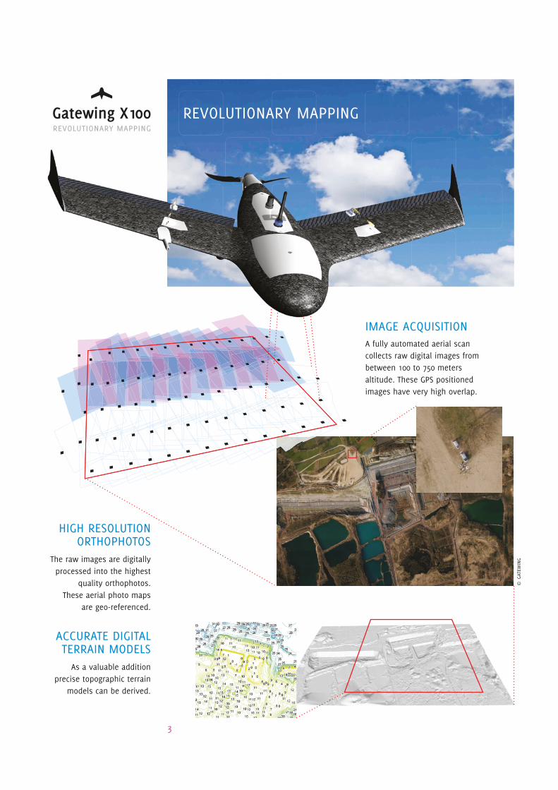
IMaGe aCQUISItIONa fully automated aerial scan collects raw digital images from between 100 to 750 meters altitude. these GPS positioned images have very high overlap.
ReVOLUtIONaRY MaPPING
aCCURate DIGItaLteRRaIN MODeLS
as a valuable addition precise topographic terrain
models can be derived.
hIGh ReSOLUtIONORthOPhOtOS
the raw images are digitally processed into the highest
quality orthophotos.these aerial photo maps
are geo-referenced.
© G
ateW
ING
3

BeNeFItS - USP• Easy and fast deployment of UAS
• Digital and automated image processing
• End products ready for GIS or CAD importing
• Highly accurate mapping of areas up to 20 km2
• Multitemporal site coverage through frequent scanning
• Make your own images whenever and wherever you need to!
category item value
Operation System setup time 15 minutes
Flight altitude range 100 - 750 m
Default flight altitude (5 cm resolution) 150 m
Overlap 75% (forward), 60% (side)
Average coverage per flight (30 min at 150 m) 2 km2
Average number of pictures per km2 (at 150 m) 400
Weather up to 6 Bft wind & light rain
Orthophoto Pixel resolution 5 cm (at default altitude)
Planimetric accuracy 1 pixel
Projection semi-true or true
Colour true RGB; no haze
DTM Point spacing 25 - 200 cm
Planimetric accuracy (XY plane) 5 cm (at default altitude)
Height accuracy (Z axis) 10 cm (at default altitude)
aPPLICatIONS• Vegetation monitoring in combined
visual and NIR spectrum for preci-sion farming and forest preservation
• Topographic surveying as a valuable alternative for LIDAR and add-on to terrestrial measurements
• Infrastructure mapping for land management and planning, visuali-zation and follow-up of projects
• Other applications? Please share your ideas with us!
SOMe DetaILS
GateWING teRRaIN MaPPINGOur new method for digital terrain mapping allows you to provide your own remote sensing imagery. Make your own recent and high quality images whenever and wherever you need to.
Let’s revolutionize the way we map the globe!
4
category item value
Wing Type Tailles, fixed wing
Weight 1.85 kg
Wingspan 100 cm
Wing area 23 dm2
Dimensions 100 x 60 x 10 cm
Material full-body EPP with carbon frame
8 cm EPP Impact nose
Configuration Propulsion E lectric brushless 250 W
Pusher prop
Battery Lipo 11.1 V, 6000 mAh
Payload Calibrated 10 MP camera
Autopilot Autonomous take-off & landing
Waypoint navigation
Autonomous camera triggering
Fail-safe routines
Performance Cruise speed 70 km/h
Max horizontal speed 115 km/h
Max vertical speed 18 km/h
Stall speed 45 km/h
Endurance 45 min
Operational range 50 km
Service ceiling 750 m AGL
Take off Take off type Catapult launch
& landing Take off speed 55 km/h
Climb angle 15 degrees
Landing type Belly landing
Landing speed 50 km/h
Landing angle 7.5 degrees
Adviced landing strip 100 x 15 m
Communication C&C link 2.4 GHz
C&C range 5 km (TBC)
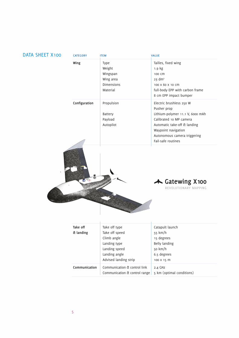
category item value
Wing Type Tailles, fixed wing
Weight 1.9 kg
Wingspan 100 cm
Wing area 23 dm2
Dimensions 100 x 60 x 10 cm
Material full-body EPP with carbon frame
8 cm EPP impact bumper
Configuration Propulsion Electric brushless 250 W
Pusher prop
Battery Lithium-polymer 11.1 V, 6000 mAh
Payload Calibrated 10 MP camera
Autopilot Automatic take-off & landing
Waypoint navigation
Autonomous camera triggering
Fail-safe routines
Performance Cruise speed 70 km/h
Max horizontal speed 115 km/h
Max vertical speed 18 km/h
Stall speed 45 km/h
Endurance 45 min
Operational range 50 km
Service ceiling 750 m AGL
Take off Take off type Catapult launch
& landing Take off speed 55 km/h
Climb angle 15 degrees
Landing type Belly landing
Landing speed 50 km/h
Landing angle 6.5 degrees
Advised landing strip 100 x 15 m
Communication Communication & control link 2.4 GHz
Communication & control range 5 km (optimal conditions)
Data Sheet X100
5