Garnet deposits near Wrangell Southeastern Alaska - … · Garnet deposits near Wrangell...
17
Garnet deposits near Wrangell Southeastern Alaska By C. T. BRESSLER MINERAL RESOURCES OF ALASKA, 1945-46 (pp. fff-93} GEOLOGICAL SURVEY BULLETIN 963-C UNITED STATES GOVERNMENT PRINTING OFFICE, WASHINGTON : 195O
Transcript of Garnet deposits near Wrangell Southeastern Alaska - … · Garnet deposits near Wrangell...
Garnet deposits near Wrangell Southeastern AlaskaBy C. T. BRESSLER
MINERAL RESOURCES OF ALASKA, 1945-46 (pp. fff-93}
GEOLOGICAL SURVEY BULLETIN 963-C
UNITED STATES GOVERNMENT PRINTING OFFICE, WASHINGTON : 195O

UNITED STATES DEPARTMENT OF THE INTERIOR
Oscar L. Chapman, Secretary
GEOLOGICAL SURVEY
W. E. Wrather, Director
For sale by the Superintendent of Documents, U. S. Government Printing Office Washington 25, D. C. - Price $1.00 (paper cover)
CONTENTS
PageAbstract_______---___--_-___-__---_-_--_-___-___-_-____--______ 81Introduction._____________________________________________________ 81
. History and production......__________________________________ 81Previous work__________________.____.__.____.__________:____ 82Field work and acknowledgements__________ _______ ______________ 82
Geography_____________________________________________________ 83Location and accessibility._____________________________________ 83Topography _________--_-_ ___---___-______-__-__-____--_____ 83Climate.__________________._________.______ 83
Geology.: --__---- ________-_-_--__-_--_-__--__----____-___--- 84General features___ _ _ _-_____-__-__-_----__-__-_-__-_____.____l_ 84Metamorphic rocks'-'.__________________________________________ 84
Distribution and character__--__--_--__-__________________ 84Structure. - -__ -__-___---___--_____-_____-___---_______-___ 86Age_._.------_------_--------._-_---__----_-----_-._____ 86
Igneous rocks.________________________________________________ 87Distribution and character________________________________ 87Structure- ________________________________________________ 88Age.rji .-_ . _ _ _ 88
Garriet; deposits._______________________________________________ 88Location, size, and grade______________________________-____ 88Mine description ______ ______________________________.__1__ 89Classification and genesis.________________-_-_---_-__-_____- 91Mineralogy_______________________________________________ 81
Index..________________-____-____-___-___-_____-___--____--___--. 93
ILLUSTRATIONS
Page PLATE 7. Generalized 'geologic map of part of the Wrangell district,
southeastern Alaska.________________________________ In pocket8. Geologic map of the Wrangell garnet mine and vicinity____ In pocket
FIGUBE 21. Tunnel map of the Wrangell garnet mine __________________ 90HI
GARNET DEPOSITS NEAR WRANGELL SOUTHEASTERN ALASKA
By C. T. BRESSLER
Almandite garnet crystals occur disseminated in schist 7% miles north of Wrangell on the east side of the Stikine River, in a region of high relief and rugged mountains covered with rain forest.
The schists are part of the Wrangell-Revillagigedo belt of regionally meta morphosed rocks that flank the west margin of the Coast Range batholith. Intrusion of an* outlying stock of quartz diorite has induced the formation of sizable garnet deposits adjacent to the contact.
Five claims, several prospects, and one adit are in the area. Production of abrasive garnet has been small and intermittent; there has been no production for the past 25 years.
Laboratory examination of Wrangell garnets indicates that they are excellent for use as an abrasive.
INTRODUCTION
The deposits of almandite garnet, occurring in schists near the east side of the mouth of the Stikine River, southeastern Alaska, have supplied for more than five decades the renowned "Fort Wrangell" garnet crystals displayed in many musuems and mineral collections. The deposits are less well known as a source of abrasive garnet, yet they have been mined intermittently for that purpose since before 1910. Prior to 1946 no detailed study of the garnet deposits had been made. In the summer of 1946, the United States Geological Survey made investigations of the deposits, which are described in this report. A generalized geologic map of Wrangell and vicinity was prepared, modified after the maps of the Wrights l and Buddington and Chapin.2 In addition, detailed geologic maps of the principal garnet deposits and of the adit at the garnet mine were prepared.
HISTORY AND PRODUCTION
The date of actual discovery of the garnet deposits is unknown, but gold seekers working the bars of the Stikine River as early as 1862, probably knew of their existence. J. D. Dana, 3 probably the
> Wright, F. E., and C. W., The Ketchikan and Wrangell mining districts, Alaska: U..S..Qeol. Survey Bull. 347, 1906.
2 Buddington, A. F., and Chapin, Theodore, Geology and mineral deposits of southeastern Alaska: U. S. Oeol. Survey Bull. 800,1929.
' Dana, J. D., System of Mineralogy, 6th_ed., 1892. Analysis of garnet from Wrangell cited on p. 442.880804-50 81
82 MINERAL RESOURCES OF ALASKA, 1945-46
first to record the presence of garnet crystals on the Stikine River, published an analysis of the-crystals by A. F. Kountze. F. E. and C. W. Wright 4 mentioned the presence of garnets along the Stikine River in the course of their investigations of the Wrangell mining district, and Knopf 5 states that a small amount of garnet was pro duced from the Wrangell district in -1910. In 1912, the Alaska Garnet Mining & Manufacturing Co. applied for a patent on two claims covering the most promising, garnet area. The same year, J. L. McPherson, civil engineer of Seattle, Wash., made a location map for United States Mineral Survey 951 embracing the garnet claims, which were at that time a portion of the unsurveyed Public Domain in the Wrangell mining district.
In 1922, the Alaska Garnet Mining & Manufacturing Co. gave a short-term lease to a small company that operated for the period of the lease. The quantity of garnets produced by the two companies is unknown, but it is probably small, as the literature contains only a few indefinite statements concerning production.
PREVIOUS WORK
The most comprehensive previous study of the garnet-bearing schists on the Stikine River is that made by Buddington 6 in 1922 while he was engaged in investigations of the mineral deposits of the Wrangell mining district. A topographic map of the district from Eastern Passage east to the Canadian Boundary was prepared by the International Boundary Commission in 1904-5. This survey constituted the first effort at accurate mapping in the Wrangell district.
FIELD WORK AND ACKNOWXEDQMENTS
The field work that provided the data for this report began June 26and ended August 5, 1946. Detailed mapping of the garnet deposits by plane table and telescopic alidade was carried out on a scale of 1inch to 200 feet. Contiguous areas, embracing approximately 4 square miles, were mapped in less detail on the same suaie. xri-ionsaerial photographs and United States Coast and Geodetic Survey nine-lens composite photographs were of great value despite the heavy timber and great relief. The entrance to the adit at the garnet mine,which had caved in approximately 25 years before, according to local sources of information, was reopened with considerable difficulty inorder to map the underground, workings.
< Wrigbt, F, E, ana 0, W,, op, cit,, p, 92, . »Knopf, Adolph, Mining in southeastern Alaska: U. S. Geol. Surv. Bull. 480-D, p. 42,1911. Buddington, A. F., Mineral deposits of the Wrangell district, Alaska: U. S. Geol. Surv. Bull. 739, pp.
61-75,1922. ' -'... ,
GARNET DEPOSITS NEAR WRANGELL, SOUTHEASTERN .ALASKA 83
The writer was aided greatly in the examination of the deposits by William T. Holser. Wayne L. Swift also served efficiently in camp and in the field.
Numerous courtesies and helpful cooperation by the citizens of Wrangell aided the investigation, and the work was facilitated espe cially by Bert and Ingvald Nore, H. R. McKibben, Neil Grant, and by Richard J. Suratt, the United States Commissioner.
GEOGRAPHY
LOCATION AND ACCESSIBILITY
The garnet deposits are on the east bank near the, mouth of the Stikine River, 7}£ miles north of Wrangell, the principal town and supply point in the Wrangell mining district. (See pi. 7.) Wrangell is served regularly by coastwise steamships carrying passengers and freight between Seattle or British Columbia and points in Alaska. Specially constructed shallow draft, high-powered boats ply the Stikine River twice a week between Wrangell and Telegraph Creek, British Columbia. These boats can stop at the garnet deposits only at high tide because of the shallow, shifting, and anastomosing channels of the muddy lower reaches of the Stikine River. Daily air service is maintained, weather permitting, between Wrangell and Juneau.
TOPOGRAPHY
The principal garnet deposits lie 750 feet east of the Stikine River in a steep narrow valley, \% miles long, which is bordered by precipi tous ridges rising from sea level to 3,010 feet, the summit of Garnet Mountain. Two forks of Garnet Creek, both of which traverse the garnet deposits, rise from snow fields on Garnet Mountain and flow over a series of cascades and waterfalls to join at a point 600 feet east of the Stikine River. Great relief and steep-walled valleys are typical of both the mainland portion of the Wrangell district and its contigu ous islands.
Dense stands of timber cover all but the steepest slopes up to timber line, which is about 2,500 feet above sea level. The under growth, consisting mainly of huckleberry bushes, alder, and devil's club, is extremely thick and in many places,, particularly on old avalanche scars, nearly impenetrable. Heather and lichens are the dominant vegetation between timber line and the permanent snow fields.
CLIMATE
Climatic records at Wrangell show that the district has relatively mild winters at the lower altitudes, with temperatures usually above zero, and cool summers with temperatures rarely above 80° F. About
'84 MINERAL RESOURCES OFiALASKA, 1945-46
60 percent of the mean annual precipitation of 78 inches occurs be tween the first of September and the last of January. . Most of the precipitation is in the form of rain below an altitude of 500 feet.
GEOLOGY
GENERAL FEATURES
The Wrangell garnet deposits lie within the Wrangell-Kevillagigedo iDelt of metamorphic rocks which comprise a complex assemblage of schists, phyllites, and slates that form the western flank of the Coast Range. The trend of this belt is, in general, parallel to the north westerly trend of the range, and the rocks dip to the northeast. Intricate and locally highly contorted folds are superimposed on the uniformly trending structures, a condition that makes difficult the determination of the origin and age of these rocks.- Intruded into this metamorphic complex is the Coast Range bath- olith of probable Jurassic age. The batholith forms the backbone of the Coast Range and is its dominant geologic feature for more than 1,100 miles along the coast from southern British Columbia northward beyond latitude 60° N. Numerous peripheral and outlying stocks, dikes, and bosses are thought generally to be genetically related to the batholith. Buddington,7 after studying many portions of the batholith in southeastern Alaska, concluded that the core is grano- dioritic in composition and that the western margin is quartz diorite, whereas the eastern margin is dominantly quartz monzonite. Lo cally there are many variations in composition ranging from, granite to diorite and more basic types.
Metamorphic and late magmatic effects associated with these large rand small intrusions are widespread, pronounced, and varied. Bed- by-bed injection gneiss, aplite, and pegmatite are conspicuous, par ticularly near intrusive contacts.
. As valley sides have been oversteepened by glaciers, the marks of avalanches are* fairly common features. Between the two mainforks of Garnet Creek at an altitude of 5OO feet is a large area of
landslide debris containing blocks of rock up to 50 feet in length.The rocks are faulted, but faults are not prominent within the
map area. Most of .the observed faults appeared to be small andwere so poorly exposed that the direction of movement was not..determined.
METAMORPHIC BOCKS
DISTRIBUTION AND CHARACTER
Schists, representative of the Wrangell-Revillagigedo metamorphic complex, .crop .out prominently for more than 800 feet in the lower
' Buddington, A. F., op. cit., pp. 178-179.
GARNET DEPOSITS NEAR WRANGELL, SOUTHEASTERN ALASKA 85
part of the valley of Garnet Greek. (See pi. 8.) Quartz diorite intrusions fringe on three sides, the several schist facies that crop out in the map area. The fourth side is obscured by the Stikine River. Similar schists are exposed south of the intrusive rocks shown on plate 8, and on Sergief Island. (See pi. 7.) Contacts between the schist and the quartz diorite are characterized by a zone of aplitic bed-by- bed injection gneiss, which generally is gradational. Locally, how ever, the contact is fairly sharp, as along the main fork of Garnet 'Creek (pi. 8) where at several points the contact zone is very narrow <or missing.
Within the areas of quartz diorite are masses of large blocks of unassimilated schist. Some smaller blocks are present as xenoliths and inclusions that were probably caught up by the invading magma.
The metamorphic rocks of the garnet area are predominantly (crystalline quartz-biotite schist with some interbedded quartzite .and quartz schist. Other metamorphic rock types, including black islaty phyllite, schistose greenstone, and crystalline limestone, crop out near the garnet area.
The more quartzose facies of the fine- to medium-grained schists commonly exhibits a gneissic structure owing to alternating layers of contrasting minerals. The fine-grained, less-quartzose schist facies .is often highly contorted and does not" show the conspicuous alternation of quartz and mica.
The mineral constituents, with the exception of the garnets, are not conspicuous for their size. The garnets are commonly less than 6 millimeters in diameter, although specimens with diameters in excess of 25 millimeters have been noted. The other minerals of the meta morphic rocks are commonly less than 1 millimeter in size.
In thin section, the schists exhibit variations in composition, tex ture, and structure. Quartz, biotite, garnet, muscovite, graphite, :and orthoclase are identified in the schists in the garnet-bearing area. In thin sections of quartzite and quartz schist, the structure is usually :a granulose aggregate of equidimensional, recrystallized quartz grains. Rudimentary schistosity is present locally where biotite flakes impart & poorly developed parallel alinement between the quartz grains. The recrystallized quartz grains show elongation only to a very minor extent. Where this occurs, the quartz is usually introduced into the body of the rock along the schistosity as quartz veinlets, or as .small apophyses of aplite or injection gneiss.
In thin sections containing large amounts of biotite and muscovite, flakes of these minerals commonly define highly contorted microfolds, and the rocks are characteristically schistose. In this facies belongs the larger part of the garnetiferous quartz-biotite schists-found in the
86 MINERAL RESOURCES OF ALASKA, 1945-46
garnet area and throughout the northeastern portion of the Wrangel- Revillagigedo belt of metamorphic rocks.
It is apparent from studies of thin sections that some of the schists in the garnet area have been subjected to at least two periods of metamorphism. The earlier of these, and the one which produced the schists, phyllites, and slates of the Wrangell-Revillagigedo metamor phic complex, was of the dynamothermal type of metamorphism on a regional scale. Thin sections of the regional garnetiferous quartz- biotite schist facies show the small garnets to be fairly idioblastic and to contain relatively few inclusions. Where the garnet is in contact with mica flakes, the latter have been spread apart by the growth of the garnet.
The idioblastic garnet crystals in the schists adjacent to the quartz diorite contact are generally of much larger size and contain innumer able inclusions. Most of the garnet metacrysts in the quartz-rich biotite schist show little or no spreading of the enclosing schist, and only in the graphite-rich schist facies is there any apparent spreading by garnet growth. Because large garnets, commonly containing in clusions and showing no spreading of the micas, are found only ad jacent to the intrusive igneous contacts, they are believed to be the result of contact metamorphism caused by the intrusion of the quartz diorite.
STRUCTURE
In the vicinity of the garnet deposits the attitude of the schists conforms to the regional pattern. Local variations in strike and dip reflect minor folds. Only two small well-defined folds are exposed inthe map area; one at the garnet mine and one at a point on the StikineRiver bank between Garnet Creek and Green Point.
Fracture cleavage is displayed in the schists. It is seen best in the garnet-mine adit where its strike is parallel to the schistosity and its dip is to the south.
AGE
. Little evidence was found within or adjacent to the garnet area by which the age of the schists could be ascertained. The only evidence of age relationship in the garnet area is that of the quartz diorite, generally regarded as Jurassic age, which intruded the Wrangell- Revillagigedo schists.
The Wrights 8 believed that the greater part of the metamorphicrocks were of Cai-bonifcrous age, and that part of the formations might include rocks of Triassic age. Buddington ° concurs wioix ti«=Wrights in assigning these rocks to the late Paleozoic and early
8 Wright, F. E., and C. W., op. cit., p. 56.' Buddington,-A. F., The Geology and mineral deposits of southeastern Alaska: TT. S. Qeol. Surv. BtllJ.
£00, p. 74,1929.
GARNET DEPOSITS NEAR WRANGELL,, SOUTHEASTERN ALASKA 87
Mesozoic. However, he believes that some of the rocks may be a& old as Devonian, whereas others may be as young as Cretaceous.
IGNEOUS BOCKSDISTRIBUTION AND CHARACTER
Most of the igneous rocks exposed near the garnet deposits are tongues of a large quartz diorite stock, and it is likely that the body of schist near the garnet mine may represent a roof pendant in this quartz diorite stock. The quartz diorite which forms the ridge southwest of Garnet Creek is only a few hundred feet wide at the Stikine River but widens to the southeast where it joins the main body of the stock. The main body of the stock trends southeastward from Point Rothsay in a broad band roughly parallel to the eastern side of Eastern Passage.
Fine- to medium-grained gray quartz diorite predominates within the stock. Variations to granodiorite occur locally, but the difference between the two types is so slight that no distinction has been made on the map. The variations in composition probably resulted from differing physico-chemical conditions in .the country rocks intruded by the stock. Porphyritic textures and gneissic structures are com paratively uncommon in the quartz diorite near the garnet-mine area. At some localities, blocks of schist were incompletely assimilated by the magma and relict structures give the rock a gneissoid appearance.
In most hand specimens of the quartz diorite, biotite and hornblende are readily distinguishable. The biotite commonly gives the appear ance of chunky plates, whereas the hornblende appears as black prismatic crystals. In thin section its texture is seen to be hypidio- morphic granular. Locally the quartz diorite is porphyritic. The average grain size is slightly greater than 1 millimeter, but occasion ally phenocrysts of biotite and hornblende as much as 3 millimeters in length are present. Less common are phenocrysts of plagioclase feldspar up to 2.8 millimeters in length.
The approximate modal composition of six representative specimens of quartz diorite from the garnet-mine area is given below..Andesine (Abeo-An^ to Ab^-
Anj4)._.______________ 53Orthoclase_________________ 3Quartz________________^_____ 17Biotite__________________ 14Hornblende________________ 7Kaolin________________ 3Sericite (muscovite)__________ 1.5
Clinozoisite_-______---__-___- 1. 0-__-_--____-____--_- . 5
Pyrite. _______-__---___-___- TraceZircon, apatite. _ _____________ Trace
100. oa
Some large plagioclase crystals, apparently older than most of the other minerals, display conspicuous zoning. The zoned plagioclase crystals are generally larger than those showing no zonal structure.
88 MINERAL RESOURCES OF ALASKA, 1945-46
All biotite crystals are deeply pleochroic, the color varying from a very pale yellow to an intense deep red brown. The biotite commonly shows large pleochroic halos surrounding zircon inclusions. The horn blende, in contrast to the biotite, displays a prismatic shape in which the length greatly exceeds the width. Neither biotite nor hornblende shows any alteration. In several specimens the larger grains of feld spars showed alteration to kaolin and sericite. Garnet is conspicuous as an accessory mineral in some specimens of the quartz diorite. Pyrite is locally abundant and appears to be one of the latest minerals for it is seen constricted between the boundaries of other minerals, notably quartz.
A few pegmatite and aplite dikes crop out within the garnet-mine area. Two dikes of pegmatite crop out on the south side of the north fork of Garnet Creek about 600 feet from the forks. This rock is coarse-grained and blocky and in color is white to yellowish white. Plagioclase and quartz are the dominant minerals, together making up 95 percent of the rock; the remainder is biotite. The biotite occurs in small books about 12 millimeters in diameter. The average grain size of the rock as a whole is about 12 millimeters.
Aplite is less easily recognized, for at many points it grades into bed-by-bed injection gneiss. It has no characteristic place of occur rence but is found near most of the borders of areas of intrusive rocks. It is a fine-grained, sugary white rock often containing stringers of biotite.
STRUCTURE
The structure of the igneous rocks is generally massive. Locally, a gneissic structure is apparent in the quartz diorite although in general it seems to be less prevalent than in most of the Coast Rangeintrusives. 10 Jointing is fairly prominent, consisting of both open joints and joints filled with aplite. The main trends of jointing arenorthward and eastward.
AGE
The age of the quartz diorite, as determined from contact rela tions outside the garnet-mine area, 11 is probably Upper Jurassic orLower Cretaceous. Within the garnet area the only evidence for age determination is its intrusion into tke scKists of iow o*- MO^O^O OI-pre-lvlesozoic age.
GARNET DEPOSITS
LOCATION, SIZE, AND GRADE
The garnet crystals, disseminated through the quartz-biotite schist, attain a size and concentration worthy of economic consideration only
10 BuddingtOJi, A. F., Geology and mineral deposits of southeastern Alaska: U. S. Geol. Surv. Bull. 800, p. 231,1929.
11 Buddington, A. F., op. cit., pp. 252, 253.
GARNET DEPOSITS NEAR WRANGELL, SOUTHEASTERN ALASKA 89
at Garnet Creek. Five garnet claims, all belonging to the Alaska Garnet Mining and Manufacturing Co. have been; located within the valley of Garnet Creek. The largest concentration of garnets is in the two patented claims Ruby No..1 and Ruby No. 2. These claims are near the mouth of Garnet Creek> which traverses both of them. (See pi. 8.) ..
The deposits, as delimited on the map, roughly form a narrow isosceles triangle extending approximately 450 feet southeast from an apex at the' confluence of the two forks of .Garnet Greek. (See.pl. 8.) The maximum width of the rich garnet-bearing zone is about 250 feet. A vertical profile across the low ridge at any point between the two forks of Garnet Creek is roughly triangular. The shape of the body of rock enclosing the deposits of highest grade is thus a rough tapering triangular prism. Above a horizontal datum plane at the level of the forks of Garnet Creek, this body of rock is estimated to have a volume of more than 2,810,000 cubic feet.
Two samples, representative of the garnet-bearing schist between the two forks of Garnet Creek, gave 4.85 and 9.26 percent of garnet by weight. (See pi. 8.) A comparison between barren schist and the two garnet-bearing schist samples is shown below:
Percent of garnet
04.859.26
Calculated specific gravity of schist
2.652.722.78 ;
Volume (cubic feet per ton)
12.111.7811.5
. *-%
Weight of garnet
(pounds per ton)
097.fr
185.2
The deposits probably will average at least 5 percent of commercial, garnet, possibly more. Miss Anna E. Durkee, 12 secretary of th& Alaska Garnet Mininge& Manufacturing> Co.,, stat.es, tfyat W. .C; Hall,, mining engineer, sa'niple'd''t;^fe7 dfepOsi:trin lt)22 a^'c'ai^lated^th'at a. ton of garnet-bearing schist contained 112.5 pounds of garnet.
If it is assumed that 11.8 cubic feet of schist containing 5 percent of garnet weighs 1 ton, then 2,810,000 cubic feet of the garnet-bearing" schist will weigh 238,136 tons and will yield 11,907 tons of garnet.
If garnet-bearing schist of the same tenor extends 20 feet below the> assumed datum plane, then a further volume of 1,125,000 cubic feet,, equivalent to 95,339 tons, is adpled; this increase^ the total to 333,475- tons of schist or 16,674 tons of garnet.
MINE DESCRIPTION
The adit of the garnet mine is located on the Ruby No. 1 claim on.:; . Garnet Creek, "265 feet southeast of the forks. (See pi. 8.) It is- easily accessible by trail from the Stikine River.
11 Personal communication, June 4,1947.
90 MINERAL RESOURCES OF ALASKA, 1945-46
^<Sfe
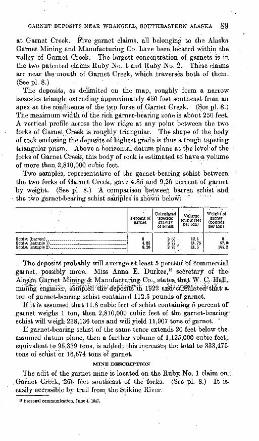
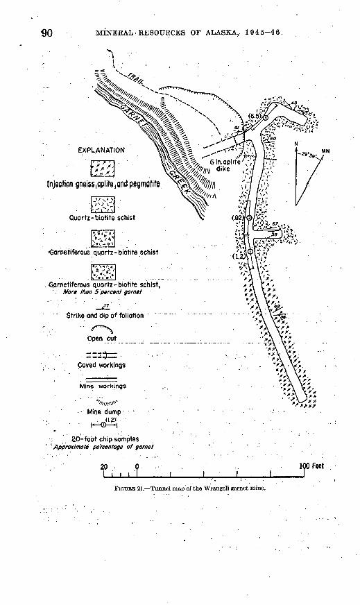
EXPLANATION
(Injection gneiss,aplite,and pegmatite
<5,arnetiferous quartz-biotite schist,
Mine workings
Mine dump(1.2).
; 20-foot chip samples* Approximate percentage of garnet
More than 5 percent garnet
^7'
"Strike and dip of foliation ' ~~~" VTTTT>^ ' .
Open cut .
. --2^=: ' .: . .Caved workings
*A \^"- A\;>........ . .4^ --%\w
A\';--,\ \s*^X\ \* *_ .-._....-,... . . .s .x .\ .yx..
- . . AYv. ''A V* ^A'Vx,
20, I i i i
100 Feet
FIOUKK 21. Tunnel map of the Wrangell garnet mine.
GARNET DEPOSITS NEAR WRANGELL, SOUTHEASTERN ALASKA 91
The underground workings consist of about 260 feet of drifts. The main drift explores the deposits for 30 feet northeastward from the present entrance; then turns to the southeast for 25 feet; Another drift, from a point 10 feet inside the main drift, extends for 162 feet in a southerly direction. It crosscuts schist with minor amounts of bed-by-bed injection gneiss for about 80, feet, beyond which the proportion of injection gneiss increases m'arkedly to the end of the drift. About 55 feet south of the mouth of this drift, a short drift, 1.7 feet long, explores the schist eastward and parallel to the schistosity.
Three chip samples taken along the west wall of the main and south drifts showed the northern part of the workings to contain an appreci ably, higher percentage of garnet, than the remainder. (See fig. 21.) The samples of garnet-bearing schist were disaggregated, with due care to avoid crushing the garnet, and the percentage of garnet by .weight was. calculated.: A cut-off size of 6 millimeters (% inch) was used, as garnets below this size have no commercial value, and most manufacturers, of'garnet products screen out everything below 13 millimeters (% inch). This cut-off size was used in the calculation of the. reserves of the deposits.-.Samples -1, 2, and 3 contained 2.1, 0.2, and 6.5 percent of garnet, respectively. As chip sampling in such deposits offers relatively inaccurate results, it is likely that samples 1 and 2 may actually be of higher grade than is indicated by the figures. Sample 3-conforms more clqsely: to the results of the two representative garnet-bearing surface samples. . . .
CLASSIFICATION AND GENESIS
The slates, phyllites, and schists that comprise the Wrangell- Revillagigedo belt of metamorphic rocks were formed by regional dynamothermal metamorphism. Contact metamorphism caused by intrusions of igneous rocks into this metamorphic series, as seen in the garnet mine area, induced the formation of large garnets in the schist. The deposits are thus classified as contact metamorphic.
MINERALOGY
These garnets have been classified by Dana 13 and others as alman- dite. The crystals range in diameter up to 44 millimeters. All the garnets have external crystallization and generally show both dodeca hedron and trapezohedron faces. As Pabst u has pointed out, the dodecahedron becomes more prominent with increase in size of the crystal. Measurement of the specific gravity of several garnets showed the value 4.1 to be constant for crystals of all sizes, and any
18 Dana, J. D., System of Mineralogy, 6th ed., p. 442, 1892.» Pabst, Adolph, Large and small garnets from Fort Wrangell, Alaska: Am. Min., Vol. 28, pp. 233-245*
1943.
92 MINERAL RESOURCES OF ALASKA, 1945-4&
slight variation commonly affects only the second or third decimal place. The hardness, based on Moh's scale, is approximately 7.5. The color is deep red.
Some of the larger crystals display a parting or lamination that generally is parallel to the plane of schistosity, and experiments showed that crystals embedded in schist would fracture parallel to the schistosity. Experiments conducted to determine the manner of fracture showed that the crystal fragments are equidimensional with sharp angular edges, even when crushed to, pass through a 230-mesh sieve.
The garnets generally show no alteration, but many crystals,, particularly those displaying parting, show oxidation of part of the iron to limonite along the planes of parting and within the internal fractures.
The crystals have no value as gems, for all contain internal frac tures. Thin sections show that the garnet crystals contain many inclusions of quartz. No zoning was seen in garnets found in the quartz diorite or in the garnet schist.
Myers and Anderson 1S give requirements for abrasive garnet, and the Wrangell garnets have physical properties analogous to the commercial garnets from New Hampshire, which are the acknowledged standards for the abrasive-garnet industry.
'»Myers, W. M., and Anderson, C. 0., Garnet Its mining, milling, and utilization: U. S, Bur. Mines Bull. 256,1925.
INDEX
PageAccessibility of the area. __________. 83,89 Acknowledgments.._.._________.. 83 Age of the rocks. _____________ 84,86-87,88 Alaska Garnet Mining & Manufacturing Co.. 82,89 Analysis (modal) of quartz diorite_.. ___. 87 Avalanche scars.._____________ 83,84
Carboniferous (?) age of schist ________ 86 Climate__________. _________ 83-84 Coast Range batholith, age................. 84,89
peripheral stocks and bosses ______ i 84,88 Cretaceous (?) age of schist. _________ 86
Devonian (?) age of schist.....________ 86 Dikes, aplite and pegmatite..._______ 88
Eastern Passage_... ____.. ___ 87
Faults . - 84Folds 84,86Fracture cleavage_______________ 86
Garnet Creek... 83,84,85,86,87,88,89Garnet deposits, claims______. ____ 89
classification and genesis.___. ____ 91content and volume.._________ 89location_______________ 88-89; pi. 8mining. See under History of mining.
size of garnets... 85,88,91size of zone__ ...___ _.. 89
Garnet Mountain. ___._ __ 83Geology, general features. 84Glacially oversteepened valley walls. ____ 84Gneiss, aplitic____ _____...._ 85Green Point._____ ..... _ .. 86
History of garnet mining....__ ..... 81-82
Localities:Eastern Passage.. .._ ___ 87 Garnet Creek.. . 83,84,85,86,87,88,89 Garnet Mountain ..... ...... 83Green Point. - -- 86Point Rothsay-__... . 87 Sergief Island______________ 85; pi. 7 Stikine River . 81,82,83,87; pi. 7 Wrangell......__....... . 83, pi. 7
Location of the area.. __ _ 83, pi. 7
Metaniorphism, late magmatic effects.. __. 84 types -.. 86,91
Mine description. 89-91; pi. 8Minerals:
biotite, in diorite . 88 in schist- - 85,87
feldspar, alteration hi igneous rock... 88 orthoclase.. . 85 plagioclase.. 87
garnets, accessory in igneous rock .. 88 in schist_______ - 85 non-gem quality 92
c
Page Minerals Continued
previous descriptions............._ 82,91use as abrasive. ._..... 92
graphite................. ............ 85,86hornblende in diorite___________ 87,88 limonite, alteration to____._.___ 92 muscovite.______________.... 85pyrite in igneous rocks_____ ____ 88
Mkiing company and claim names.....___ 82,89
Point Rothsay,________________ 87 Precipitation, mean annual_________'... 84
Rocks:aplite dikes, filling on joints.. ______ 88
occurrence_____________ 84,85,88diorite and other basic phases..._____ 84granodiorite. ________.____ 84,87gneiss, aplitic_______________ 85,88
injection. . __....-..-....-. 84-85greenstone, schistose.___________ 85 limestone, crystalline_____._____ 85 pegmatite......_.___......._...... 84,88quartz diorite, hornblende in. ______ 87
modal composition.._________ 87occurrence___.__.______ 84,85,87-88quartz monzonite____.... ..--.-... 84
quartzite..------___________.. 85schists, garnetiferous. . _..._ 85,89
general features..__ 84-85, 91; pis. 7 and 8 gneissic structure in.... ..___. 85graphitic.....-...-.------__.--..... 85,86quartz.__________.____. 85 quartz-biotite ....._.. ......... 85,88
slate................. ............... 84,86,91Roof pendants...__......-..-.-.-...--. .. 85,87
Sampling and samples__... -------- 91Sergief Island_______________ 85; pi. 7 Stikine River- - . -- 81, 82, 83, 87, 92; pi. 7 Structure:
attitude...... . .. 84,86faults . 84folds.. 84,86fracture cleavage. . . 86 gneissic..___ . . 88 Joints, in part.aplite filled._______.. 88 roof pendants__ 85,87 xenoliths... -. 85,87
Temperatures, seasonal -.... 83Timber line..--..--...------ --------- 83Topography of the area. . 83Trails.. 89
Vegetation. 83
Waterfall . - 83Wrangell- - 83; pi. 7Wrangell mining district. . 83 Wrangell-Revillagigedo belt or complex.... 84,86,91
Xenoliths.----- 85,87
93