Gangtok Smart City Development Limited -...
16
Gangtok Smart City Development Limited Implementation of Multi - Level Car Parking cum Commercial Development at Old West Point School Area near M.G. Marg, Gangtok – East Sikkim O n Design, Build , Finance , Operate and Transfer ( DB F O T basis ) Volume II I – Project Information Memorandum
Transcript of Gangtok Smart City Development Limited -...

Gangtok Smart City Development Limited
Implementation of Multi - Level Car Parking cum
Commercial Development at Old West Point School
Area near M.G. Marg, Gangtok – East Sikkim
O n
Design, Build , Finance , Operate and Transfer
( DB F O T basis )
Volume II I – Project Information Memorandum

Implementation of Multi-Level Car Parking cum Commercial Development at Old West Point School Area near M.G. Marg, Gangtok – East Sikkim on Design, Build, Finance, Operate and Transfer (DBFOT)
basis Volume III – Project Information Memorandum
Page 2 of 16
Table of Contents
1. Introduction ......................................................................................................................... 3
1.1. Gangtok ............................................................................................................................... 4
1.2. Gangtok Civic Administration ........................................................................................... 5
2. The Project Site ................................................................................................................... 8
2.1. Project Site .......................................................................................................................... 8
2.2. Parking demand at Project Site ..................................................................................... 12
3. Commercial Development................................................................................................ 14
3.1. Project Site – Vicinity to M.G. Marg............................................................................... 14
3.2. Allowed Commercial Development ............................................................................... 15
3.3. Restricted Commercial Development ........................................................................... 15
4. Project Site Map ................................................................................................................ 16
Implementation of Multi-Level Car Parking cum Commercial Development at Old West Point School Area near M.G. Marg, Gangtok – East Sikkim on Design, Build, Finance, Operate and Transfer (DBFOT)
basis Volume III – Project Information Memorandum
Page 3 of 16
1. Introduction
Sikkim is a state in northeast India. It borders Tibet in the north and northeast, Bhutan in the
east, Nepal in the west, and West Bengal in the south. Sikkim is also located close to India's
Siliguri Corridor near Bangladesh. Sikkim is the least populous and second smallest among
the Indian states. A part of the Eastern Himalaya, Sikkim is notable for its biodiversity, including
alpine and subtropical climates, as well as being a host to Kanchenjunga, the highest peak in
India and third highest on Earth. Sikkim's capital and largest city is Gangtok. Almost 35% of
the state is covered by the Khangchendzonga National Park. The Kingdom of Sikkim was
founded by the Namgyal dynasty in the 17th century. It was ruled by a Buddhist priestking
known as the Chogyal. It became a princely state of British India in 1890. After 1947, Sikkim
continued its protectorate status with the Republic of India. It enjoyed the highest literacy rate
and per capita income among Himalayan states. In 1973, anti-royalist riots took place in front
of the Chogyal's palace. In 1975, the monarchy was deposed by the people. A referendum in
1975 led to Sikkim joining India as its 22nd state.
The state's economy is largely agrarian based on the terraced farming of rice and the
cultivation of crops such as maize, millet, wheat, barley, oranges, tea, and cardamom. Sikkim
produces more cardamom than any other Indian state and is home to the largest cultivated
area of cardamom and is the world's second largest producer of the spice after Guatemala.
Sikkim achieved its ambition to convert its agriculture to fully organic over the interval 2003 to
2016, the first state in India to achieve this distinction. It is also among India's most
environmentally conscious states, having banned plastic water bottles and styrofoam products.
Because of its hilly terrain and poor transport infrastructure, Sikkim lacks a large-scale
industrial base. Brewing, distilling, tanning and watchmaking are the main industries and are
mainly located in the southern regions of the state, primarily in the towns of Melli and Jorethang.
In addition, a small mining industry exists in Sikkim extracting minerals such as copper,
dolomite, talc, graphite, quartzite, coal, zinc, and lead. Despite the state's minimal industrial

Implementation of Multi-Level Car Parking cum Commercial Development at Old West Point School Area near M.G. Marg, Gangtok – East Sikkim on Design, Build, Finance, Operate and Transfer (DBFOT)
basis Volume III – Project Information Memorandum
Page 4 of 16
infrastructure, Sikkim's economy has been among the fastest-growing in India since 2000; the
state's GDP expanded by 89.93% in 2010 alone. In 2003, Sikkim decided to fully convert to
organic farming and achieved this goal in 2015 becoming India's first "organic state".
In recent years, the government of Sikkim has extensively promoted tourism. As a result, state
revenue has increased 14 times since the mid-1990s. Sikkim has furthermore invested in a
fledgling gambling industry promoting both casinos and online gambling. The state's first
casino, the Casino Sikkim, opened in March 2009, and the government subsequently issued
a number of additional casino licences and online sports betting licenses. The Playwin lottery
has been a notable success in the state. The opening of the Nathu La pass on 6 July 2006,
connecting Lhasa, Tibet, to India, was billed as a boon for Sikkim's economy. Trade through
the pass remains hampered by Sikkim's limited infrastructure and government restrictions in
both India and China, though the volume of traded goods has been steadily increasing.
1.1. Gangtok
Gangtok is a city, municipality, the capital and the largest town of Sikkim. It also is the
headquarters of the East Sikkim district. Gangtok is located in the eastern Himalayan range,
at an elevation of 1,650 m (5,410 ft). The town's population of 100,000 are from different
ethnicities such as Nepalis, Lepchas and Bhutia. Nestled within higher peaks of the Himalaya
and enjoying a year-round mild temperate climate, Gangtok is at the centre of Sikkim's tourism
industry.
Gangtok rose to prominence as a popular Buddhist pilgrimage
site after the construction of the Enchey Monastery in 1840. In
1894, the ruling Sikkimese Chogyal, Thutob Namgyal,
transferred the capital to Gangtok. In the early 20th century,
Gangtok became a major stopover on the trade route between
Lhasa in Tibet and cities such as Kolkata in British India.
Gangtok is the main base for Sikkim tourism. Summer and
spring seasons are the most popular tourist seasons. Many of
Gangtok's residents are employed directly and indirectly in the tourism industry, with many
residents owning and working in hotels and restaurants. M. G. Marg is one of the main
shopping and cultural activity streets in Gangtok. Ecotourism has emerged as an
important economic activity in the region which includes trekking, mountaineering, river
rafting and other nature-oriented activities.

Implementation of Multi-Level Car Parking cum Commercial Development at Old West Point School Area near M.G. Marg, Gangtok – East Sikkim on Design, Build, Finance, Operate and Transfer (DBFOT)
basis Volume III – Project Information Memorandum
Page 5 of 16
The Nathula Pass, located about 50 km from Gangtok, used to be the primary route of the
wool, fur and spice trade with Tibet and spurred economic growth for Gangtok till the mid-20th
century. In 1962, after the border was closed during the Sino-Indian War, Gangtok fell into
recession. The pass was reopened in 2006 and trade through the pass is expected to boost
the economy of Gangtok. The Sikkim government is keen to open a Lhasa–Gangtok bus
service via Nathula pass.
Gangtok's economy does not have a large manufacturing base but has a thriving Cottage
industry in watch-making, country-made alcohol and handicrafts. Among the handicrafts are
the handmade paper industry made from various vegetable fibres or cotton rags. The main
market in Gangtok provides many of the state's rural residents a place to offer their produce
during the harvest seasons. The majority of the private business community is made up of
Marwaris and Biharis. As part of Sikkim, Gangtok enjoys the status of being an income-tax
free region as per the state's 1948 Income tax law. Following schematic depicts the SWOT
analysis of Gangtok:
1.2. Gangtok Civic Administration
Gangtok is administered by the Gangtok Municipal
Corporation along with the various departments of the
Government of Sikkim, particularly the Urban
Development and Housing Department (UDHD) and the
Public Health Engineering Department (PHED). These
departments provide municipal functions such as
garbage disposal, water supply, tax collection, license
allotments, and civic infrastructure. An administrator
appointed by the state government heads the UDHD.
Strength Largest city in Sikkim Well connected Strong heritage and cultural centre Upcoming education hub, with a very high literacy ratio Tourist attraction Power and water surplus city
Weakness Difficult terrain and availability of land Inadequate public transport system Lack of manufacturing activity Lack of branding of City’s tourism potential
Opportunity Opening off Nathula Pass should enhance business opportunities Demand for organic food should create business opportunity for local farmers Ever improving tourism activity in the City and State
Threats Natural calamities Haphazard growth Competition from other North Eastern States Stressed infrastructure

Implementation of Multi-Level Car Parking cum Commercial Development at Old West Point School Area near M.G. Marg, Gangtok – East Sikkim on Design, Build, Finance, Operate and Transfer (DBFOT)
basis Volume III – Project Information Memorandum
Page 6 of 16
As the headquarters of East Sikkim district, Gangtok houses the offices of the district collector,
an administrator appointed by the Union Government of India. Gangtok is also the seat of the
Sikkim High Court, which is India's smallest High Court in terms of area and population of
jurisdiction. Gangtok does not have its own police commissionerate like other major cities in
India. Instead, it comes under the jurisdiction of the state police, which is headed by a Director
General of Police, although an Inspector General of Police oversees the town. Sikkim is known
for its very low crime rate. Rongyek jail in Gangtok is Sikkim's only central jail.
1 Source: Urban Development and Housing Department, Government of Sikkim www.sikkim.nic.in
1.2.1. Gangtok Smart City Development Limited
The Smart Cities Mission is an innovative and new initiative by the Government of India to
drive economic growth and improve the quality of life of people by enabling local development
and harnessing technology as a means to create smart outcomes for citizens.
The Gangtok Smart City Development Limited (GSCDL), the Authority of the Project, has been
formed by the Gangtok Municipal Corporation along with Government of Sikkim to implement
various area based as well as pan-city level projects under Smart City Mission. The Gangtok
Municipal Corporation has entrusted GSCDL to implement the said Project. The GSCDL will
plan, appraise, approve, release funds, implement, manage, operate, monitor and evaluate
various Smart City development projects in Gangtok.
Urban Development and Housing Department Proposed Land - use Pattern of Gangtok
Keeping in view of the rapid urbanization vis - à - vis the requirement of infrastructures, the Department ha s prepared the Master Plans for Gangtok town, which envisages perspective planning. These objectives can be achieved through the broad strategies being adopted by the department. Plans are being formulated to develop Gangtok Town as a Model City 1 .

Implementation of Multi-Level Car Parking cum Commercial Development at Old West Point School Area near M.G. Marg, Gangtok – East Sikkim on Design, Build, Finance, Operate and Transfer (DBFOT)
basis Volume III – Project Information Memorandum
Page 7 of 16
1.2.2. Gangtok Utility Services
Electricity is supplied by the power department of the Government of Sikkim. Gangtok has a
nearly uninterrupted electricity supply due to Sikkim's numerous hydroelectric power stations.
The rural roads around Gangtok are maintained by the Border Roads Organisation, a division
of the Indian army. Most households are supplied by the central water system maintained and
operated by the PHED. The main source of PHED water supply is the Rateychu River, located
about 16 km from the city, at an altitude of 2,621 m (8,599 ft). Its water treatment plant is
located at Selep. The river Rateychu is snow-fed and has perennial streams. Since there is no
habitation in the catchment area except for a small army settlement, there is little
environmental degradation and the water is of very good quality.
Around 40% of the population has access to sewers. However, only the toilet waste is
connected to the sewer while sullage is discharged into the drains. Without a proper sanitation
system, the practice of disposing sewage through septic tanks and directly discharging into
Jhoras and open drains is prevalent. The entire city drains into the two rivers, Ranikhola and
Roro Chu, through numerous small streams and Jhoras. Ranikhola and Roro Chu rivers
confluence with Teesta River, the major source of drinking water to the population downstream.
The densely populated urban area of Gangtok does not have a combined drainage system to
drain out the storm water and waste water from the buildings. The estimated solid waste
generated in Gangtok city is approximately 45 tonnes per day. Only around 40% of this is
collected by UDHD, while the remainder is indiscriminately thrown into Jhora, streets and
valleys. The collected waste is disposed in a dump located about 20 km from the city. There
is no waste collection from inaccessible areas where vehicles cannot reach, nor does any
system of collection of waste exist in the adjoining rural areas. The city is under a statewide
ban on the use of polythene bags.
1.2.3. Connectivity
Road: Taxis are the most widely available public transport within
Gangtok. Most of the residents stay within a few kilometres of
the town centre and many have their own vehicles such as two-
wheelers and cars. The share of personal vehicles and taxis
combined is 98% of Gangtok's total vehicles, a high percentage
when compared to other Indian cities. City buses comprise less
than one percent of vehicles. Those travelling longer distances
generally make use of share-jeeps, a kind of public taxis. Four-
wheel drives are used to easily navigate the steep slopes of the
roads.
Gangtok is connected to the rest of India by an all-weather metalled highway, National
Highway 10, earlier known as National Highway 31A, which links Gangtok to Siliguri, located
114 km away in the neighbouring state of West Bengal. The highway also provides a link to
the neighbouring hill station towns of Darjeeling and Kalimpong, which are the nearest urban
areas. Regular jeep, van, and bus services link these towns to Gangtok. Gangtok is a linear
city that has developed along the arterial roads, especially National Highway 31A. Most of the

Implementation of Multi-Level Car Parking cum Commercial Development at Old West Point School Area near M.G. Marg, Gangtok – East Sikkim on Design, Build, Finance, Operate and Transfer (DBFOT)
basis Volume III – Project Information Memorandum
Page 8 of 16
road length in Gangtok is of two lane undivided carriageway with footpath on one side of the
road and drain on the other. The steep gradient of the different road stretches coupled with a
spiral road configuration constrain the smooth flow of vehicular as well as pedestrian traffic.
Rail: The nearest railhead connected to the rest of India is the station of New Jalpaiguri in
Siliguri, situated 124 km away from Gangtok. Work has commenced for a broad-gauge railway
link from Sevoke in West Bengal to Rangpo in Sikkim that is planned for extension to Gangtok.
Air: Pakyong Airport, a Greenfield project near Gangtok, was commissioned in 2018. It is the
first and only airport in Sikkim.
2. The Project Site
Parking is an essential component of any city's transportation system. Managing public and
private parking spaces is an integrated aspect of a planned urban transportation system. This
plays an important role in increasing the capacity of existing roadways, improving traffic
circulation and reducing urban chaos in the city. The unprecedented growth in the number of
motor vehicles, especially the taxis and cars along with the concentration of activities has led
to acute parking problems in the Gangtok City area. As the road space is limited and On-Street
parking is not possible on all roads, parking demand far outstrips the supply equation.
Moreover, there are limited parking lots leading to spill-over of on-street parking on the main
carriageway and impending the movement of the traffic stream.
Accordingly, GSCDL, under smart city program has identified various Multi-Level Car Parking
projects to be implemented on priority. Under the program, GSCDL has identified an existing
MLCP, which will be demolished and upgrade into a state of the art, modern MLCP cum
Commercial Development at Old West Point School Area near M.G. Marg on a DBFOT basis.
2.1. Project Site
Implementation of Multi-Level Car Parking cum Commercial Development at Old West Point School Area near M.G. Marg, Gangtok – East Sikkim on Design, Build, Finance, Operate and Transfer (DBFOT)
basis Volume III – Project Information Memorandum
Page 9 of 16
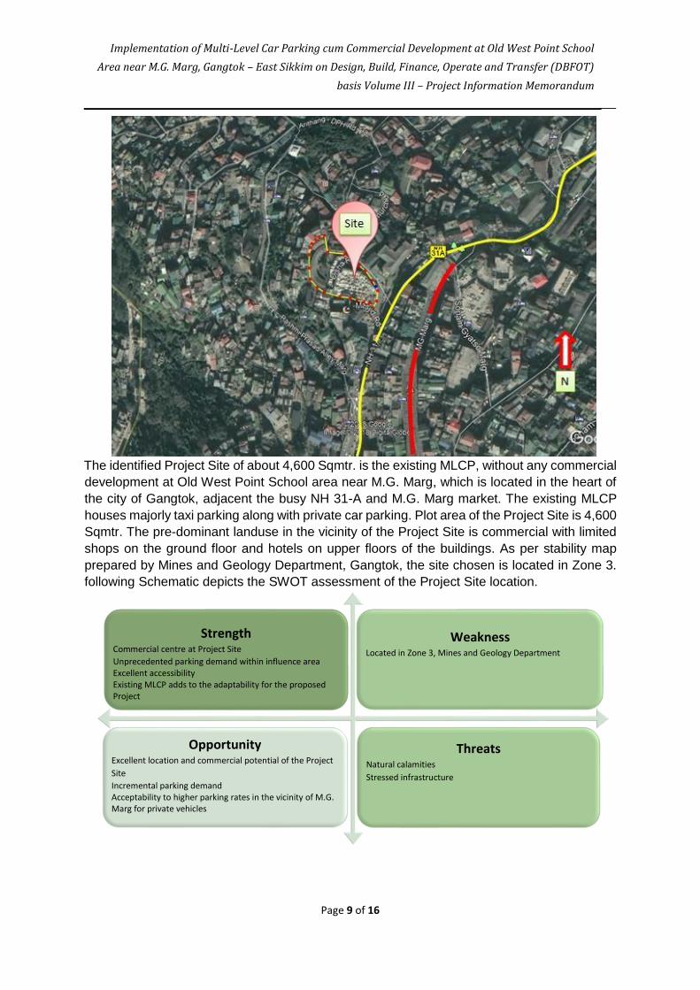
The identified Project Site of about 4,600 Sqmtr. is the existing MLCP, without any commercial
development at Old West Point School area near M.G. Marg, which is located in the heart of
the city of Gangtok, adjacent the busy NH 31-A and M.G. Marg market. The existing MLCP
houses majorly taxi parking along with private car parking. Plot area of the Project Site is 4,600
Sqmtr. The pre-dominant landuse in the vicinity of the Project Site is commercial with limited
shops on the ground floor and hotels on upper floors of the buildings. As per stability map
prepared by Mines and Geology Department, Gangtok, the site chosen is located in Zone 3.
following Schematic depicts the SWOT assessment of the Project Site location.
Strength Commercial centre at Project Site Unprecedented parking demand within influence area Excellent accessibility Existing MLCP adds to the adaptability for the proposed Project
Weakness Located in Zone 3, Mines and Geology Department
Opportunity Excellent location and commercial potential of the Project Site Incremental parking demand Acceptability to higher parking rates in the vicinity of M.G. Marg for private vehicles
Threats Natural calamities Stressed infrastructure
Implementation of Multi-Level Car Parking cum Commercial Development at Old West Point School Area near M.G. Marg, Gangtok – East Sikkim on Design, Build, Finance, Operate and Transfer (DBFOT)
basis Volume III – Project Information Memorandum
Page 10 of 16
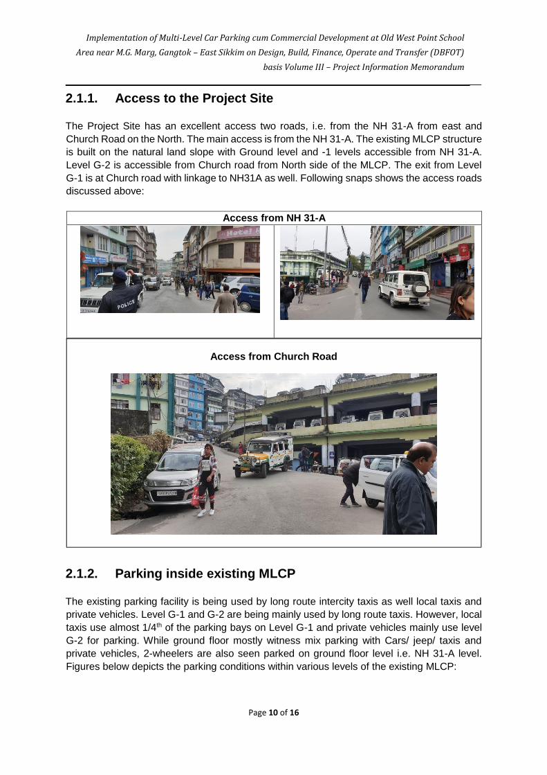
2.1.1. Access to the Project Site
The Project Site has an excellent access two roads, i.e. from the NH 31-A from east and
Church Road on the North. The main access is from the NH 31-A. The existing MLCP structure
is built on the natural land slope with Ground level and -1 levels accessible from NH 31-A.
Level G-2 is accessible from Church road from North side of the MLCP. The exit from Level
G-1 is at Church road with linkage to NH31A as well. Following snaps shows the access roads
discussed above:
Access from NH 31-A
2.1.2. Parking inside existing MLCP
The existing parking facility is being used by long route intercity taxis as well local taxis and
private vehicles. Level G-1 and G-2 are being mainly used by long route taxis. However, local
taxis use almost 1/4th of the parking bays on Level G-1 and private vehicles mainly use level
G-2 for parking. While ground floor mostly witness mix parking with Cars/ jeep/ taxis and
private vehicles, 2-wheelers are also seen parked on ground floor level i.e. NH 31-A level.
Figures below depicts the parking conditions within various levels of the existing MLCP:
Access from Church Road

Implementation of Multi-Level Car Parking cum Commercial Development at Old West Point School Area near M.G. Marg, Gangtok – East Sikkim on Design, Build, Finance, Operate and Transfer (DBFOT)
basis Volume III – Project Information Memorandum
Page 11 of 16
Parking at NH 31-A level
Parking at G-1 Level
Parking at G-2 Level
As it can be seen, at present, no proper parking bay system is being followed at the existing
MLCP. Due to overspill of demand, the parking facility is under tremendous pressure and
operates beyond its capacity. As such, even the parking aisles are used for parking wherein
cars continuously shifted to give way to an incoming or outgoing vehicle.
2.1.3. Passenger and other infrastructur facilities
The existing MLCP is of very basic nature in terms of passenger amenities and other
infrastructural facilities with poorly maintained public toilet and an unplanned passenger
waiting area. In absence of a regularised canteen, many unorganised eatery points are

Implementation of Multi-Level Car Parking cum Commercial Development at Old West Point School Area near M.G. Marg, Gangtok – East Sikkim on Design, Build, Finance, Operate and Transfer (DBFOT)
basis Volume III – Project Information Memorandum
Page 12 of 16
operational, mostly at level G-1 and level G-2. Levels G-1 and G-2 are connected by staircase
within the building footprint. Although a passenger enquiry counter is operational, no IT based
information system is in place. Signages, rate card and in & out terminals are missing at all
levels.
Currently most of the users are not satisfied with the manual ticketing management system.
Private vehicle owners, while are satisfied with the parking rates (during office time and night
charges), they are generally unsatisfied with the overall management system. The
maintenance of the MLCP is another prominent issue reported by the users. The existing
building is not being maintained as per good industry standards, with issues pertaining to
cleanliness, proper illumination and other safety aspects.
2.2. Parking demand at Project Site
The existing demand at the proposed Project Site has been estimated at 280 vehicles in peak
hour, with 91% of 4 wheelers (cars/Jeeps) and only 9% of two wheelers. The corresponding
peak hourly demand is about 260 ECS. Reconnaissance survey for the proposed MLCP site
was carried out on December 04, 2018 and on-site parking survey was conducted on
December 05, 2018. On-street and off-street parking surveys were carried out to acquire data
on parking accumulation, duration and parking turnover. This information is utilized to infer the
demand for parking and the extent of the parking required in terms of the number of equivalent
car spaces (ECS) to be built. Primary surveys were carried out to obtain information on:
Parking Accumulation
Parking Duration
Parking Turnover
2.2.1. Parking accumulation
Manual counting has been done at different hours of the day to ascertain the parking
accumulation at the existing facility. The actual holding capacity of the existing site is 165 ECS
(Equivalent Car Spaces). The accumulation survey reveals the existing facility is being
operated beyond its capacity. For the purpose of understanding of the on-street parking
scenario in the vicinity of the Site survey had been carried out at the Tibet Road, with following
results:
Parking Survey Count Nos. Composition
Private Cars 88 33%
2 Wheelers 25 9%
Local Taxi 80 30%
Long Route Taxi 75 28%
Total 268

Implementation of Multi-Level Car Parking cum Commercial Development at Old West Point School Area near M.G. Marg, Gangtok – East Sikkim on Design, Build, Finance, Operate and Transfer (DBFOT)
basis Volume III – Project Information Memorandum
Page 13 of 16
Time
Two
Cars
Wheelers
Jeeps LCV
Heavy
Trucks
Total
Vehicles Hourly Accumulation
9:00 - 9:30 15 0 15 0 0 30 9:00 - 10:00 31
9:30 - 10:00 16 0 15 0 0 31 9:30 - 10:30 39
10:00 - 10:30 20 0 19 0 0 39 49
10:30 - 11:00 25 0 24 0 0 49 58
11:00 - 11:30 29 0 29 0 0 58
64
11:30 - 12:00 31 0 33 0 0 64 64
Time Cars Two
Wheelers Jeeps LCV
Heavy
Trucks
Total
Vehicles Hourly Accumulation
12:00 - 12:30 33 0 26 0 0 59 59
12:30 - 1:00 34 0 25 0 0 59 59
1:00 - 1:30 28 0 26 0 0 54 54
1:30 - 2:00 24 0 16 0 0 40 50
2:00 - 2:30 29 0 21 0 0 50 57
2:30 - 3:00 31 0 26 0 0 57 57
3:00 - 3:30 26 0 29 0 0 55
55
3:30 - 4:00 34 0 21 0 0 55 56
4:00 - 4:30 31 0 25 0 0 56 56
4:30 - 5:00 32 0 22 0 0 54 54
5:00 - 5:30 22 0 20 0 0 42 47
5:30 - 6:00 23 0 24 0 0 47 47
6:00 - 6:30 17 0 21 0 0 38 18:00 - 19:00 38
6:30 - 7:00 16 0 22 0 0 38
2.2.2. Parking duration

Implementation of Multi-Level Car Parking cum Commercial Development at Old West Point School Area near M.G. Marg, Gangtok – East Sikkim on Design, Build, Finance, Operate and Transfer (DBFOT)
basis Volume III – Project Information Memorandum
Page 14 of 16
Following is the result of on-street parking survey conducted at Tibet Road, near Project Site
for understanding the parking duration:
Classification of Duration of Parking
S. No Duration of
Parking
Designation of
Parking
Survey Count Info %age
1 < 1 Hour Very Short Duration 160 37%
2 1 to 2 Hours Short Duration 143 33%
3 2 to 4 Hours Medium Duration 54 13%
4 4 to 6 Hours Long Duration 31 7%
5 > 6 Hours Long Term Parking 42 10%
Total 430 100%
3. Commercial Development
3.1. Project Site – Vicinity to M.G. Marg
M.G. Marg is a 'must visit' place in Gangtok and this is the town center of the hill town. M.G.
Marg is also the main market area of Gangtok. The road and the area around it has
transformed over the years. It is now more like a long stretch of open mall or boulevard square
where locals and tourists take leisure stroll or just sit and relax on one of the many benches
laid along the middle and both sides of the road to soak in the ambience.

Implementation of Multi-Level Car Parking cum Commercial Development at Old West Point School Area near M.G. Marg, Gangtok – East Sikkim on Design, Build, Finance, Operate and Transfer (DBFOT)
basis Volume III – Project Information Memorandum
Page 15 of 16
The road is lined up with glittering shops,
restaurants, cafes & bars on both sides.
Many tourists take a table on a roadside
restaurant and watch the activities on the
street. It's like a carnival like atmosphere
out here. In line with government's
green initiative, all buildings on
both sides of this road are painted green.
The Statue of Unity
overlooks MG Marg. The statue comprises of the figures of Bhutia Chieftain Khye Bumsa, the
Lepcha leader Thetong Tek and his wife Ngo-Kong-ngol. The statue depicts peace, love and
harmony. About midway is an imposing statue of Mahatma Gandhi. There are Victorian lamps
along this road. When lit up after dark, the entire place looks magical. As part of Gangtok
Annual Food and Culture Festival that takes place in the month of December, many different
food stalls are set up at the Titanic park in MG Road, cultural shows take place here opposite
to Sikkim Tourism & Civil Aviation Department where ethnic dance performances and musical
shows are organized.
3.2. Allowed Commercial Development
The Concessionaire shall be entitled to construct/ develop such components which it deems
appropriate from commercial viability point of view provided however that such component
does not fall in the category of prohibitive item as per Authority or GoS or GOI norms or
applicable law. Following are the Optional Development components permissible within
Commercial Development:
Shopping Mall
Multiplex
Hotel
Food Courts/Restaurants/ coffee shop
Commercial (Retail cum Office) Area would include retail shopping, branded showrooms,
anchor stores, Entertainment Complex/ Zone and business spaces
Banks
Coaching Institutes
Gaming Zone/children play home
Gymnasium or Health Centre
Any other activity with the approval of Authority
3.3. Restricted Commercial Development
Following functions / products are not permitted for development:
Industrial activities
Hostel
Warehousing (except such warehousing facility which is incidental to the use of the Project)
Wholesale Activity
Car Service Garage

Implementation of Multi-Level Car Parking cum Commercial Development at Old West Point School Area near M.G. Marg, Gangtok – East Sikkim on Design, Build, Finance, Operate and Transfer (DBFOT)
basis Volume III – Project Information Memorandum
Page 16 of 16
Workshops
Hospitals or health centers
Other environmentally incompatible functions
4. Project Site Map
(to be incorporated)