Game Management Unit 53 - NMDGF - New Mexico … · then west along NM 570 to its junction with NM...
1
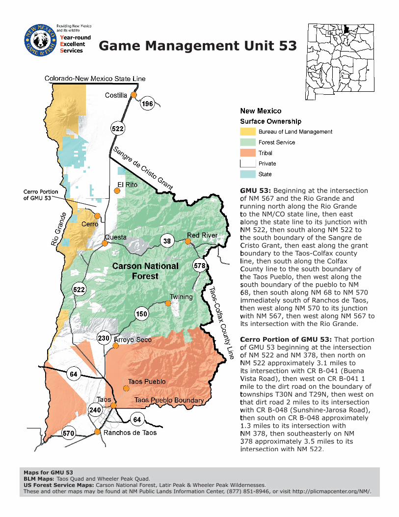
Game Management Unit 53 Maps for GMU 53 BLM Maps: Taos Quad and Wheeler Peak Quad. US Forest Service Maps: Carson National Forest, Latir Peak & Wheeler Peak Wildernesses. These and other maps may be found at NM Public Lands Information Center, (877) 851-8946, or visit http://plicmapcenter.org/NM/. GMU 53: Beginning at the intersection of NM 567 and the Rio Grande and running north along the Rio Grande to the NM/CO state line, then east along the state line to its junction with NM 522, then south along NM 522 to the south boundary of the Sangre de Cristo Grant, then east along the grant boundary to the Taos-Colfax county ine, then south along the Colfax County line to the south boundary of the Taos Pueblo, then west along the south boundary of the pueblo to NM 68, then south along NM 68 to NM 570 mmediately south of Ranchos de Taos, then west along NM 570 to its junction with NM 567, then west along NM 567 to ts intersection with the Rio Grande. Cerro Portion of GMU 53: That portion of GMU 53 beginning at the intersection of NM 522 and NM 378, then north on NM 522 approximately 3.1 miles to ts intersection with CR B-041 (Buena Vista Road), then west on CR B-041 1 mile to the dirt road on the boundary of townships T30N and T29N, then west on that dirt road 2 miles to its intersection with CR B-048 (Sunshine-Jarosa Road), then south on CR B-048 approximately 1.3 miles to its intersection with NM 378, then southeasterly on NM 378 approximately 3.5 miles to its ntersection with NM 522.
Transcript of Game Management Unit 53 - NMDGF - New Mexico … · then west along NM 570 to its junction with NM...
Game Management Unit 53
Maps for GMU 53BLM Maps: Taos Quad and Wheeler Peak Quad.US Forest Service Maps: Carson National Forest, Latir Peak & Wheeler Peak Wildernesses.These and other maps may be found at NM Public Lands Information Center, (877) 851-8946, or visit http://plicmapcenter.org/NM/.
GMU 53:GMU 53: Beginning at the intersection of NM 567 and the Rio Grande and of NM 567 and the Rio Grande and running north along the Rio Grande running north along the Rio Grande to the NM/CO state line, then east to the NM/CO state line, then east along the state line to its junction with along the state line to its junction with NM 522, then south along NM 522 to NM 522, then south along NM 522 to the south boundary of the Sangre de the south boundary of the Sangre de Cristo Grant, then east along the grant Cristo Grant, then east along the grant boundary to the Taos-Colfax county boundary to the Taos-Colfax county line, then south along the Colfax line, then south along the Colfax County line to the south boundary of County line to the south boundary of the Taos Pueblo, then west along the the Taos Pueblo, then west along the south boundary of the pueblo to NM south boundary of the pueblo to NM 68, then south along NM 68 to NM 570 68, then south along NM 68 to NM 570 immediately south of Ranchos de Taos, immediately south of Ranchos de Taos, then west along NM 570 to its junction then west along NM 570 to its junction with NM 567, then west along NM 567 to with NM 567, then west along NM 567 to its intersection with the Rio Grande.its intersection with the Rio Grande.
Cerro Portion of GMU 53:Cerro Portion of GMU 53: That portion of GMU 53 beginning at the intersection of GMU 53 beginning at the intersection of NM 522 and NM 378, then north on of NM 522 and NM 378, then north on NM 522 approximately 3.1 miles to NM 522 approximately 3.1 miles to its intersection with CR B-041 (Buena its intersection with CR B-041 (Buena Vista Road), then west on CR B-041 1 Vista Road), then west on CR B-041 1 mile to the dirt road on the boundary of mile to the dirt road on the boundary of townships T30N and T29N, then west on townships T30N and T29N, then west on that dirt road 2 miles to its intersection that dirt road 2 miles to its intersection with CR B-048 (Sunshine-Jarosa Road), with CR B-048 (Sunshine-Jarosa Road), then south on CR B-048 approximately then south on CR B-048 approximately 1.3 miles to its intersection with 1.3 miles to its intersection with NM 378, then southeasterly on NM NM 378, then southeasterly on NM 378 approximately 3.5 miles to its 378 approximately 3.5 miles to its intersection with NM 522.intersection with NM 522.
Cerro Portionof GMU 53