GALVESTON COUNTY CONSOLIDATED DRAINAGE DISTRICT …€¦ · The City of Friendswood, the City of...
45
GALVESTON COUNTY CONSOLIDATED DRAINAGE DISTRICT (GCCDD) DRAINAGE CRITERIA MANUAL Approved: September 22, 2009 Effective: September 25, 2009 LENTZ ENGINEERING, L.C. CONSULTING ENGINEERING AND PLANNERS 4710 Bellaire Blvd., Suite 250 Bellaire, Texas 77401 Phone 713-839-8900 Fax 713-839-9020
Transcript of GALVESTON COUNTY CONSOLIDATED DRAINAGE DISTRICT …€¦ · The City of Friendswood, the City of...

GALVESTON COUNTY CONSOLIDATED DRAINAGE DISTRICT
(GCCDD)
DRAINAGE CRITERIA MANUAL
Approved: September 22, 2009
Effective: September 25, 2009
LENTZ
ENGINEERING, L.C.
CONSULTING ENGINEERING AND PLANNERS 4710 Bellaire Blvd., Suite 250 Bellaire, Texas 77401
Phone 713-839-8900 Fax 713-839-9020

TABLE OF CONTENTS
I. INTRODUCTION
A. Purpose .................................................................................. 3
B. Policy...................................................................................... 3
C. Jurisdiction ............................................................................ 3
II. ADMINISTRATION
A. Predevelopment Review ...........................................................5
B. Submittal ..................................................................................5
C. Fee .......................................................................................... .6
D. Site Visit .................................................................................. .6
E. Datum ...................................................................................... .6
F. Preliminary Plat Review ........................................................... .6
G. Preliminary Plat Approval ........................................................ .7
H. Final Plat Review ..................................................................... .7
I. Final Plat Approval ................................................................... .8
J. Short Form Plat Submittal ........................................................ .8
K. Pre-application Meeting Required ……………………………..….9 L. Preliminary Drainage Plan Review ........................................... 11
M. Preliminary Drainage Plan Approval ......................................... 13
N. Final Drainage Plan Review ..................................................... 13
O. Final Drainage Plan Approval ................................................... 15
P. Project Acceptance .................................................................. 16
Q. Maintenance of Storm Water Detention Facilities ...................... 16
R. Time Limits of Approvals ......................................................... 17
S. Revisions to Drainage Plans and Plats .................................... 17
T. Utility, Pipeline, and Cable Crossings ....................................... 17
U. Regional and Sub-Regional Detention Facilities ....................... 19
III. VARIANCES ................................................................................. 19
IV. ENFORCEMENT .......................................................................... 20
V. RIGHTS OF APPEAL ................................................................... 22
VI. HYDROLOGY A. Storm Frequency .................................................................... 23
B. Rational Method ...................................................................... 24

GCCDD CRITERIA MANUAL
VII. DETENTION STORAGE A. General Policy ........................................................................ 25
B. Hydrologic Method for Projects of 100 Acres or Less ............... 26
C. Detention Storage Methodology for Projects over 100 Acres ...28
VIII. DETENTION POND STRUCTURAL REQUIREMENTS
A. Outfall Design ......................................................................... 31
B. Pond Details ........................................................................... 32
EXHIBITS I. Rational Method Runoff Coefficients ........................................ 35 II. Rainfall Intensity Coefficients .................................................. 36
III. Hydrograph .............................................................................. 37
APPENDICES
APPENDIX A
Signature Block ................................................................. 38
APPENDIX B
Required Plat and Plan Notes ........................................... 39
APPENDIX C
Rights-Of-Ways and Easements ....................................... 41
APPENDIX D
Variance Request Information Form .................................. 43
APPENDIX E Plan Submittal Flow Chart…………………………………….44
ELEVATION REFERENCE MARKS…………..……...………………….45

GCCDD CRITERIA MANUAL
Page 3
I. INTRODUCTION
A. Purpose
This DRAINAGE CRITERIA MANUAL provides a guide for use by Developers and Engineers to follow for the preparation of drainage plans for development within the GALVESTON COUNTY CONSOLIDATED DRAINAGE DISTRICT (the DISTRICT). It establishes rules and regulations that must be consistently followed and will be enforced throughout the DISTRICT'S jurisdiction. These are minimum requirements and additional requirements may be imposed and/or additional data may be required by the DISTRICT.
B. Policy
Due to the nature of the watersheds within the DISTRICT'S boundaries and the existence of flood plains that exceed the banks of the creeks in most cases, it is the policy of the DISTRICT to maintain zero net increase in runoff due to development. Although it is the DISTRICT'S long-term goals to construct and maintain facilities (channels and regional detention facilities) that will contain 100 year storm flows within drainage right-of-ways, it is recognized that further impacts cannot be tolerated in the interim period. It is further recognized that impacts outside of the DISTRICT'S boundaries are also unacceptable and the DISTRICT is dependent and supportive of the action of others to construct upstream and downstream facilities to accommodate 100-year flows.
It is the goal of the DISTRICT to complete channelization and improvements to the major Creeks within its jurisdiction in general conformance with the ”Clear Creek Regional Flood Control Plan”, dated December 1992, the “Clear Creek Regional Flooding Control Project – Harris County and Brazoria County, Texas” prepared by the Corps of Engineers dated June 23, 2008, the “Regional Drainage Study, Mary’s, Cowarts and Chiggers Watershed” dated August 21, 2001, the “Cowart Creek Modeling Update” prepared by Dannenbaum Engineering dated January 2009, and the “Dickinson Bayou Watershed Regional Drainage Plan” dated December 1994. The DISTRICT further intends to be an active participant in the Clear Creek Regional Flood Plan, the Corps of Engineer’s Clear Creek Project, the Clear Creek Steering Committee, the Dickinson Bayou Watershed Steering Committee and the Dickinson Bayou Watershed Regional Drainage Plan. The DISTRICT will also support and cooperate with the City of Friendswood, the City of League City, Galveston County and other governmental entities to improve local drainage.
C. Jurisdiction
The area within the DISTRICT is drained entirely by five (5) major drainage arteries: Clear Creek, Mary's Creek, Coward’s Creek, Chigger Creek, and Dickinson Bayou. Subdivisions and other developments in the area, which are not located directly on one of these major drainage arteries, are generally drained by man-improved or man-made ditches and storm sewers, which convey the rainfall runoff to the major drainage artery. Responsibility for provision and maintenance of drainage facilities is uniquely

GCCDD CRITERIA MANUAL
Page 4
divided between the City of Friendswood, City of League City, Galveston County, the Texas Department of Transportation and the DISTRICT in the following manner: The DISTRICT has jurisdiction for all creeks, streams, ditches, and outfalls into such drainage arteries within the DISTRICT'S boundaries. The DISTRICT is responsible for the maintenance of those creeks, streams, ditches, and outfalls, which drain 100 acres, or more within the DISTRICT'S boundaries. The City of Friendswood, the City of League City, and Galveston County are responsible for the maintenance of those drainage ways that drain less than 100 acres (such as storm sewers or roadside ditches) at the time of development. The Texas Department of Transportation is responsible for all drainage systems within the rights-of-way of any State controlled facility. The DISTRICT is chartered by the State of Texas to manage the above-named drainage arteries. The Board of Directors is charged with the responsibility of developing policy and enacting resolutions to implement the intent as well as the laws of the State Legislature and the DISTRICT’S Master Drainage Plan. The DISTRICT’S Master Drainage Plan for the area within its jurisdiction has been approved by the State of Texas (the Texas Water Development Board, formerly the Texas Department of Water Resources) and identifies guidelines for the Right-of-Way and Easement requirements along all creeks, bayous, streams, gullies and ditches; drainage areas and channel design and size for each major drainage artery as it is improved.
D. In the event that any one or more of the provisions contained in the
DRAINAGE CRITERIA MANUAL shall, for any reason, be held to be invalid, illegal or unenforceable in any respect, such invalidity, illegality or unenforceability shall not affect any other provisions of this MANUAL, but this MANUAL shall be construed as if such invalid, illegal or unenforceable provisions had never been contained herein, unless the deletion of such provision or provisions would result in such a material change so as to cause application of the criteria contemplated herein to be unreasonable.
E. When this DRAINAGE CRITERIA MANUAL requires the DISTRICT to provide written notice, such notice shall be sent by certified mail, return receipt requested to the person receiving such notice or an attorney or agent authorized to accept notice.
F. In computing any period of time prescribed or allowed by the procedures in this DRAINAGE CRITERIA MANUAL, the day of the act or event after which the designated period of time begins to run is not to be included. The last day of the period so computed is to be included, unless it is a Saturday, Sunday or legal holiday, in which event the period runs until the end of the next day which is not a Saturday, Sunday or legal holiday.

GCCDD CRITERIA MANUAL
Page 5
G. The DRAINAGE CRITERIA MANUAL is effective on the third (3rd) day after the publication of the MANUAL, following adoption or amendment and shall continue to be in effect until otherwise amended or repealed.
II. ADMINISTRATION
A. Predevelopment Review
Each person or entity planning to construct any improvements within the DISTRICT shall meet with the DISTRICT'S staff to determine whether that person or entity shall submit a Drainage Plan to the DISTRICT for approval. Any improvements that are included in a previously approved plan or master plan that meet the requirements of that plan or master plan and that meets the requirements of this Criteria Manual may not require the submittal of a plan to the DISTRICT. If the proposed improvements are not part of a previously approved plan, at a Drainage Plan meeting these requirements must be submitted to the DISTRICT for approval. In addition, any improvement located within the limits of the existing channel or the designated Flood Plain or Flood Way of any channel or stream must be approved by the DISTRICT.
The DISTRICT and the City of Friendswood, City of League City, Galveston County and other governmental entities may from time to time enter into Interlocal Governmental Contracts and pass Joint Resolutions agreeing to share certain review responsibilities. The Developer should make himself aware of these agreements prior to commencing design.
B. Submittal
One (1) copy of plans, plats, reports, and calculations shall be submitted to the DISTRICT’S Operations Manager’s office for review at least two (2) weeks prior to the meeting at which the item will be considered. One (1) copy of all documents shall also be submitted directly to the DISTRICT’S Engineer. After all plans, plats, reports and calculations have been reviewed and have been found to meet the DISTRICT’S requirements, the DISTRICT’S Engineer will notify the developer, his agent or his engineer that six (6) copies of all documents shall be provided to the DISTRICT one week prior to the scheduled meeting. Preliminary and final plats and plans, to be considered separately, shall be submitted for each development unless an overall drainage plan for the development has been previously approved, in which case the applicant can proceed directly to final with the DISTRICT'S prior approval. For projects of 100 acres or more or out of tracts of 100 acres or more, approval of a preliminary engineering report and conceptual master plan shall be required, detailing design methodology and concepts for drainage of the project prior to preliminary plat approval. All plans and reports must be prepared and sealed by a Registered Professional Engineer and must contain the Firm’s registration number.
GCCDD CRITERIA MANUAL
Page 6
C. Fees
Plats and plans submitted to the DISTRICT for approval must be accompanied by a check made payable to the DISTRICT as follows: GCCDD or Galveston County Consolidated Drainage District for an amount specified in the Schedule of Fees as determined by the Board of Directors and on file at the DISTRICT’S Office or see the DISTRICT’S website.
D. Site Visit
A representative of the property owner or developer shall meet with DISTRICT personnel at the project site prior to preliminary approval.
E. Datum
All plats and plans must be related to the Monuments as designated by the DISTRICT. A list of these monuments is available at the DISTRICT Office, the office of the DISTRICT’S Engineer or the DISTRICT’S Website. No exceptions will be made to this policy.
F. Preliminary Plat Review
The preliminary plat shall depict the applicant’s overall layout for the proposed development. The preliminary plat shall contain the following:
1) Name of owner, address, phone number and contact person.
2) Name, address, phone number and contact person of surveyor who
prepared the plat.
3) Scale of Drawing with a minimum scale of 1 inch (") = 100 feet (').
4) Benchmark and reference benchmark with year of adjustment.
5) A detailed location or vicinity map drawn to scale. The project site shall be accurately located on the map.
6) Date on all submittals with date of all revisions with month, day and year.
7) Signature lines for DISTRICT Directors in accordance with APPENDIX A.
8) DISTRICT notes in accordance with APPENDIX B.
9) Ownership of adjacent tracts if unplatted or lot and block numbers, if
platted.
10) Contour lines at 0.5 foot (.5’) where slopes do not exceed 1.0% and 1 foot (1’) intervals for slopes exceeding 1.0% intervals covering the entire development and extended beyond the development boundaries at least 200 feet (200’) on all sides for developments over 5 acres and 50 feet (50’) on development under 5 acres.
GCCDD CRITERIA MANUAL
Page 7
11) Points at which structures or pipelines will cross drainage ditches, streams etc., within the development.
12) Location of all existing drainage structures, utility lines, pipelines and
other underground features on the property and adjacent right-of-ways.
13) Location and dimensions of all proposed drainage easements and right-of-ways. Guidelines for right-of-ways and easements are listed in APPENDIX C.
14) Public detention facilities shall be placed in "Restricted Reserves-
Restricted to Detention Use Only". These Reserves shall have a minimum width of twenty feet (20') and shall have a minimum of twenty feet (20’) of free and clear unobstructed access to a public street or right-of-way.
15) Location of major drainage arteries adjacent to or crossing the
development as determined through actual ground survey by the developer’s surveyor. Survey shall have been completed within the past year and shall show stream alignment 200 feet (200’) upstream and downstream of development.
G. Preliminary Plat Approval
1) The DISTRICT shall provide comments to the applicant as soon as possible after submittal. At least five (5) working days prior to the DISTRICT'S Board of Director's regularly scheduled meeting, revised plats addressing all comments of the DISTRICT must be submitted to the DISTRICT'S Office and the DISTRICT'S Engineer. If all comments have been addressed, the plat will be placed on that agenda.
2) At the DISTRICT’S Board of Director’s meeting at which preliminary approval is being considered, one (1) blueline copy of the revised plat shall be submitted
H. Final Plat Review
The Final Plat shall be in accordance with the approved preliminary plat. The submittal shall include the following:
1) Developer’s name, address, phone number and contact person.
2) Name, address, phone number and contact person of surveyor who
prepared the plat.
3) Scale of drawing with a minimum scale of 1 inch (1") = 100 feet (100').
4) Benchmark and reference benchmark with year of adjustment.
5) A detailed location or vicinity map drawn to scale. The project site shall be accurately located on the map.

GCCDD CRITERIA MANUAL
Page 8
6) Date on all submittals with date of all revisions, including month, day and year.
7) Signature lines for DISTRICT Directors in accordance with APPENDIX A.
8) DISTRICT notes in accordance with APPENDIX B.
9) Ownership of adjacent tracts if unplatted or lot and block numbers, if
platted.
10) Drainage easements and dedicated Fee Simple Right-of-Ways along all creeks, bayous, streams, gullies and ditches. (SEE APPENDIX C).
11) Public detention facilities shall be placed in "Restricted Reserves-
Restricted to Detention Use Only". These Reserves shall have a minimum width of twenty feet (20') and shall have a minimum of twenty feet (20’) of free and clear unobstructed access to a public street or right-of-way.
12) True locations of existing creeks, bayous, streams, gullies, and ditches, as determined by actual ground survey, current within one year of approval of the Preliminary Plat. Show stream alignment 200 feet (200’) upstream and 200 feet (200’) downstream of development.
I. Final Plat Approval
1) The DISTRICT shall provide comments to the applicant as soon as
possible after submittal. At least five (5) working days prior to the DISTRICT'S Board of Director’s regularly scheduled meeting, revised plats addressing all comments of the DISTRICT must be submitted to the DISTRICT'S Office and the DISTRICT'S Engineer. If all comments have been addressed and the DISTRICT has received written confirmation from the City that they have no objection, the plat will be placed on the next available agenda.
2) At the DISTRICT’S Board of Directors meeting at which final approval is
being considered, the following shall be submitted:
(a) Final plat mylars.
(b) One (1) blueline copy of plat.
J. Short Form Plat Submittal
A development consisting of no more than two lots can be submitted under the DISTRICT'S Short Form Procedure. A final plat containing all applicable requirements of the Final Plat Submittal Section of this Manual can be submitted to the DISTRICT for approval. The plat will be reviewed consistent with the DISTRICT'S review process and items needing to be addressed must be completed prior to the DISTRICT'S Board meeting. No conditional approvals will be granted. This short form process addresses plats only and is

GCCDD CRITERIA MANUAL
Page 9
not to be used for grading and drainage plans.
K. 1. PRE-APPLICATION MEETING REQUIRED
A pre-application meeting with the DISTRICT’S Operations Manager and the DISTRICT Engineer is required before a submittal can be made to the DISTRICT. The pre-application meeting will provide the applicant with an opportunity to discuss the proposed construction with DISTRICT personnel for the purpose of establishing what hydrologic modeling will be necessary. During the meeting, DISTRICT personnel will also provide the applicant with information regarding the availability of existing hydrologic models, which might be used. The DISTRICT will make a determination during this meeting as to whether or not any existing models may need to be updated. Failure to request and attend this meeting could result in studies, which are improperly coordinated or prepared. Improperly coordinated or prepared studies will be rejected by the DISTRICT. A Drainage Impact Analysis may be required when:
• A tract or any part thereof consisting of 100 acres or more.
• The proposed construction includes realignment or modification of a public drainage way within the DISTRICT. This shall also include projects, which propose inline detention.
• A bridge or culvert crossing of a public drainage way within the DISTRICT is proposed.
• The proposed work will redirect flows from one watershed to another.
• The proposed construction has the potential to modify or impact the 100-year flood plain and/or floodway.
• The proposed development will outfall into a public facility that cannot accommodate these flows.
• The Flood Plain Administrator or DISTRICT personnel require a study.
2. General Requirements for Drainage Impact Analysis Reports
a) Name, address, and phone number of the engineer that prepared the drainage impact analysis. The engineer shall also sign and seal the report and the Firm’s registration number must be contained on the report.
b) All drawings and exhibits shall include a standard Engineer’s scale. Whenever possible, a minimum scale of 1 inch (1”) = 100 feet (100’) shall be used.
c) Exhibits shall include contour lines at 0.5 foot (.5’) intervals where slopes do not exceed 1.0% and 1 foot (1’) intervals for slopes exceeding 1.0% for the entire subject area whenever possible.

GCCDD CRITERIA MANUAL
Page 10
d) Exhibits shall include the true location of all existing creeks, bayous, streams, gullies and ditches, as determined by actual on the ground survey information which is less than one year old.
e) All elevations on drawings or in hydrologic models shall be tied to a benchmark, datum, and year of adjustment as required in Section II. E. If a DISTRICT benchmark is not used, an adjustment must be provided to get to the DISTRICT datum and year of adjustment.
f) All submittals must be dated with the month, day and year. Any revisions must be dated in the same manner.
g) All submittals must be in U.S. Customary units.
3. Content of the Drainage Impact Analysis Report
a) A location or vicinity map drawn to scale must be provided to show the subject area for the drainage impact analysis in an approximate manner. For projects, which are not entirely within the DISTRICT boundary, the exhibit shall show the DISTRICT boundary in an approximate manner in relation to the area of study.
b) Discuss what additional agencies have jurisdictional authority over the proposed project and the status of coordination, submittals, and approvals from those agencies.
c) Include copies of the most current (FIRM) FEDERAL INSURANCE RATE MAP panel(s) in the area of the proposed work with the project limits drawn to scale on the maps. Discuss how the current 100-year flood plain and/or floodway might be impacted by the proposed improvements and how these impacts will be mitigated. Alternatively, include a statement that the flood plain and floodway will not be adversely affected by the proposed improvements.
d) Confirm in writing that all proposed ponds and ditches modeled in the hydrologic analysis conform to the DISTRICT’S geometric requirements. Alternatively, briefly discuss any non-conforming drainage structures.
e) Discuss the need for drainage easements for any existing or proposed drainage features pursuant to the DISTRICT’S criteria and how the required easements will be obtained.
f) An extreme event sheet flow analysis that describes how the developed flows will be conveyed to the detention facility or the point of outfall. The analysis shall also include discussion of adjacent properties as applicable.
g) Discussion of potential conflicts (eg. pipelines) identified during the preliminary engineering analysis including a proposed conceptual approach to resolving the conflict. Proposed encroachments onto easements or fee strips held by others shall be discussed in a similar
GCCDD CRITERIA MANUAL
Page 11
manner.
h) Provide a summary of findings in the report, which demonstrates that no increase in the 5-year, 25-year, or 100-year flows will occur as a result of the proposed improvements. The findings shall also demonstrate that no increase in the water surface elevation of the receiving system will occur for the 5-year, 25-year or 100-year events.
i) Provide an electronic copy of all hydrologic models discussed in the report on a CD-ROM. This submittal shall include the base (pre-development) model. Include the name and version number for the required modeling software required to run each model.
L. Preliminary Drainage Plan Review
The preliminary plan shall present the applicant’s overall approach to moving rainfall runoff to the appropriate drainage artery. It is recommended that prior to preparation of the plan a meeting be arranged between the applicant and DISTRICT Staff to discuss the proposed concept for drainage of the project. The preliminary submittal shall contain the following items.
1) Name, address and phone number of the engineer that prepared the
plan including contact person and the Firm’s registration number.
2) Scale of drawing with a minimum scale of 1 inch (1") = 100 feet (100').
3) Benchmark and reference benchmark with datum and year of adjustment.
4) A detailed location or vicinity map drawn to scale. The project site shall
be accurately located on the map.
5) Date on all submittals with date of all revisions with month, day and year.
6) Signature lines for DISTRICT Directors in accordance with APPENDIX A.
7) DISTRICT notes in accordance with APPENDIX B.
8) Contour lines at 0.5 foot (0.5’) where slopes do not exceed 1.0% and 1 foot (1’) intervals for slopes exceeding 1.0% intervals covering the entire development and extended beyond the development boundaries at least 200 feet (200’) on all sides for developments over 5 acres and 50 feet (50’) on developments under 5 acres. At least two contours are required for each project.
9) Preliminary scheme for the passage of sheet flow from adjacent
properties.
10) Drainage area divides for project area, with peak run-off rates for each drainage area.

GCCDD CRITERIA MANUAL
Page 12
11) Locations of all planned drainage improvements proposed for moving run-off water from the development to the principle drainage artery, i.e., creek, stream, bayou, ditch etc., and their point(s) of entry into the drainage artery.
12) Points at which structures or pipelines will cross drainage ditches,
streams etc., within the development require the DISTRICT’s approval.
13) Locations of structures or other physical features on the development area to provide orientation as required during field inspection of the site.
14) Location of all existing drainage structures, utility lines, pipelines and
other underground features on the property and adjacent street right-of-ways.
15) Location and dimensions of all proposed drainage easements and right-
of-ways. Guidelines for right-of-ways and easements are listed in APPENDIX C.
16) Public detention facilities shall be placed in "Restricted Reserves-
Restricted to Detention Use Only". These Reserves shall have a minimum width of twenty feet (20') and shall have a minimum twenty feet (20’) of free and clear unobstructed access to a public street or right-of-way.
17) Location of major drainage arteries adjacent to or crossing the
development as determined through actual ground survey by the developer's engineer. Survey shall have been completed within the past year and shall show stream alignment 200 feet (200’) upstream and downstream of development.
18) Cross-section of detention facility. (Must be on plan).
19) Detention calculations in accordance with SECTION VII including
volumetric calculations of detention provided.
20) If the project is located in the Flood Plain, preliminary Flood Plain mitigation calculations shall be provided.
21) Drainage area map of receiving system, if discharging to existing storm
sewer system. Drainage area of receiving channel, if discharging to open ditch or stream. Calculations to prove capacity are available.
22) Copy of application for TxDOT permit if draining to their system.
23) Copies of documents and letters of request for permission to cross privately held easements or right-of-ways.
24) Show limits of 100-year flood plain by a vertically controlled survey and
not scaled from the (FIRM) FEDERAL INSURANCE RATE MAP.

GCCDD CRITERIA MANUAL
Page 13
25) Ownership of adjacent properties.
26) Copy of request for Corps permit for construction work within Clear Creek, Chigger Creek, Coward's Creek, Mary's Creek or Dickinson Bayou.
M. Preliminary Drainage Plan Approval
1) The DISTRICT shall provide comments to the applicant as soon as
possible after submittal. At least five (5) working days prior to the DISTRICT'S Board of Directors regularly scheduled meeting, revised plans addressing all comments of the DISTRICT must be submitted to the DISTRICT'S Office and the DISTRICT'S Engineer. If all comments have been addressed, the plan will be placed on that agenda.
2) At the DISTRICT’S Board of Directors meeting at which preliminary
approval is being considered, one (1) blueline copy of the plan must be submitted.
N. Final Drainage Plan Review
The final submittal shall consist of detailed construction drawings and final drainage calculations. The overall concept shall be in accordance with the approved preliminary plan with final design details, as they will be submitted to the contractor for construction. Design guidelines are given in SECTION III, IV, V and APPENDIX E. The submittal shall include the following: 1) Name, address, phone number and contact person of the engineer that
prepared the plans and the Firm’s registration number.
2) Scale of drawing with a minimum scale of 1 inch (1") = 100 feet (100').
3) Benchmark and reference benchmark with year of adjustment.
4) A detailed location or vicinity map drawn to scale. The project site shall be accurately located on the map.
5) Date on all submittals with date of all revisions, including month, day and
year.
6) Signature lines for DISTRICT Directors in accordance with APPENDIX A.
7) DISTRICT notes in accordance with APPENDIX B.
8) Contour lines at 0.5 foot (0.5’) intervals where slopes do not exceed 1.0% and one foot (1’) intervals for slopes exceeding 1.0% intervals covering the entire development and extended beyond the development boundaries at least 200 feet (200’) on all sides for developments over 5 acres and 50 feet (50’) on developments under 5 acres. At least two contours are required for each project.

GCCDD CRITERIA MANUAL
Page 14
9) Lot grading plan which provides for the passage of sheet flow from adjacent property
10) A 100-year sheet flow analysis that provides direct access to the
detention facility and/or the receiving stream.
11) Drainage area divides for project area, with peak run-off rates for each inlet, structure or drainage area.
12) Locations of pipelines, utility lines, drainage structures, buildings or other
physical features on the property and adjacent right-of-ways.
13) Drainage easement and dedicated Fee Simple Right-of-Ways along all creeks, bayous, streams, gullies, and ditches. (SEE APPENDIX C.)
14) Public detention facilities shall be placed in "Restricted Reserves-
Restricted to Detention Use Only". These Reserves shall have a minimum width of twenty feet (20') and shall have a minimum twenty feet (20’) of free and clear unobstructed access to a public street or right-of-way.
15) True locations of existing creeks, bayous, streams, gullies, and ditches,
as determined by actual ground survey, current within one (1) year of approval of the Preliminary Plan. Show stream alignment 200 feet (200’) upstream and 200 feet (200’) downstream of development.
16) Cross-section of existing and proposed detention facility or ditch.
Calculations to verify capacity must be furnished.
17) Details of all ditches, which are to convey rainfall runoff from a subdivision and/or through a subdivision to the appropriate major drainage artery and location of that major drainage artery. All ditches must comply with specifications in APPENDIX C.
18) Complete construction plans for the development with plan and profile
drawings of all lines to be dedicated to the public. Plans shall include details of all storm sewer structures. Storm sewers shall comply with specifications in of the City of Friendswood, City of League City or Galveston County as applicable. Outfalls to be constructed within the DISTRICT’S right-of-ways or easements shall be constructed according to the DISTRICT'S standard details.
19) Final detention calculations in accordance with SECTION VII with
volumetric calculations of detention provided and Flood Plan mitigation.
20) Calculations for sizing all storm sewers, culverts, ditches, and structures.
21) Copy of TxDOT permit if applicable.
22) Copies of letters of approval from entities holding easements or right-of-ways to be crossed.

GCCDD CRITERIA MANUAL
Page 15
23) All construction activities resulting in a land disturbance of equal to or greater than one acre or is part of a larger common plan of development or sale shall comply with TCEQ Construction General Permit No. TXR15000. A Storm Water Pollution Prevention Plan (SWP3) including adequate sediment and erosion control shall be submitted. The SWP3 shall also contain measures to control discarded building material, concrete truck washout water, chemicals, litter and sanitary waste generated at each construction site. A copy of the Notice of Intent (NOI) and Notice of Termination must be filed with the DISTRICT.
24) All sheet flow from the subdivision or project shall be directed to the
detention facility. The inlets and storm sewer prior to discharges into the facility shall be sized to accept and convey the 100-year discharge including all sheet flow. A lined emergency overflow swale shall also be provided over the storm sewer to the pond.
25) Copy of the Corps of Engineers permit for any construction within Clear
Creek, Chigger Creek, Coward’s Creek, Mary’s Creek or Dickinson Bayou.
26) Plans shall also be submitted to the DISTRICT providing for the
installation of structural and/or non-structural controls to address storm water runoff from new developments and redevelopment projects that disturb an area equal to or greater than one acre, including projects that are less than one acre that are part of a larger common plan of development or sale. The selected controls must prevent or minimize water quality impacts. A report shall be presented that describes the control measures and defines the entity or persons that will ensure long term operation and maintenance. A copy of the Notice of Intent must be filed with the DISTRICT.
O. Final Drainage Plan Approval
1) The DISTRICT shall provide comments to the applicant as soon as
possible after submittal. At least five (5) working days prior to the DISTRICT'S Board of Directors regularly scheduled meeting, revised plans addressing all comments of the DISTRICT must be submitted to the DISTRICT'S Office and the DISTRICT'S Engineer. If all comments have been addressed and the DISTRICT has received written confirmation from the City that the plan has been approved, the plan will be placed on the next available agenda.
2) At the DISTRICT'S Board of Directors meeting at which final
approval is being considered, the original and one (1) blueline copy of the plan must be submitted.
3) Final approval is valid for one (1) year. If construction does not
commence within one (1) year of approval, the drainage plan must be resubmitted for review and approval.

GCCDD CRITERIA MANUAL
Page 16
P. Project Acceptance
1) Upon completion of all construction the applicant shall notify the DISTRICT in writing, requesting an inspection of the project. The applicant shall submit one (1) hard copy and one (1) CD using AutoCAD format of the as-built plans. The applicant shall also provide the DISTRICT a one (1) year maintenance bond in the full amount of construction cost.
2) The DISTRICT shall inspect the construction and notify the applicant
of any deficiencies. The applicant shall correct all the deficiencies and request a subsequent re-inspection.
3) Once all deficiencies are corrected, the Board will accept the facility
and the DISTRICT will issue the applicant a letter of acceptance subject to the one (1) year maintenance period. For those facilities to be maintained by the DISTRICT, the acceptance of the facility shall be placed on the next available Board agenda for approval and acceptance subject to the one (1) year maintenance period.
4) It is the responsibility of the person or entity to ensure that all improvements (infrastructure) are completed in accordance with the approved Drainage Plan, that all fees are paid, and that all conditions of the DISTRICT are satisfied prior to application for a municipal building permit. The applicant agrees no municipal building permit will be sought for the proposed construction until all drainage and detention facilities are constructed, inspected and approved by the DISTRICT.
5) Prior to the end of one (1) year maintenance period, the DISTRICT will
re-inspect the facility. The applicant will be notified in writing of any deficiencies and these deficiencies shall be corrected prior to the release of the maintenance bond.
Q. Maintenance of Storm Water Detention Facilities
In each case where an on-site storm water storage facility is provided pursuant to this CRITERIA MANUAL, the developer shall furnish evidence of acceptance for maintenance of such storage facility to the DISTRICT. The DISTRICT will agree to assume such responsibility provided:
1) The developer dedicates to the DISTRICT in fee the area of such facility,
including maintenance berms.
2) The developer dedicates an access easement of at least twenty foot (20') width to such facility, from a public street or right-of-way.
3) The developer pays to the DISTRICT the estimated cost of maintaining
such storage facility for a period of ten (10) years as determined by the Board of Directors and on file in the DISTRICT’S office or the

GCCDD CRITERIA MANUAL
Page 17
DISTRICT’S website.
4) The on-site storm water detention system facility is designed to be a "dry" facility and not an amenity or a private recreational facility. Amenity ponds shall be defined as any pond whose land area has been deeded to the Homeowner/Landowners for the benefit of the Homeowner/Landowners Association. These ponds shall include "wet ponds".
5) For the purpose of this section, a storm water storage facility shall mean a storm water storage facility serving primarily as a collection device and not as a transmission system, and which is designed and constructed for the purpose of providing on-site detention for the benefit of a multi-parcel development, and not for a single lot or single parcel development.
6) This does not include DISTRICT personnel in performance of
DISTRICT work. Liability for all sites maintained by the DISTRICT shall remain with the grantor of custody and control of the site. The DISTRICT shall be an additional insured on a policy of liability insurance throughout the term of the maintenance agreement.
R. Time Limits of Approvals
1) Preliminary approvals shall expire within six (6) months if a final approval
has not been obtained. In cases where a preliminary approval is given for the entire development and only sections are given final approval, the preliminary approval will be valid for two (2) years.
2) Final approval is valid for one (1) year.
3) Upon written request, the Board may grant extensions of approval for up
to six months. All requests for extensions must be approved prior to the expiration of the original approval. No more than one (1) extension will be granted.
S. Revisions to Drainage Plans and Plats
1) The DISTRICT must approve all revisions to either the approved plat or
drainage plan.
2) The DISTRICT may require a re-submittal of a preliminary drainage plan or plat dependent upon the changes made.
T. Utility, Pipeline, and Cable Crossing
1) All utilities, pipelines, and cable crossings, either publicly or privately
owned, shall obtain a permit from the DISTRICT prior to any construction to cross any drainage facility within the DISTRICT’S boundaries.
2) All utilities, pipelines, and cables shall cross DISTRICT facility within 20
degrees of perpendicular to that facility. No utility, pipeline, or cable shall be located within and parallel to a creek right-of-way.

GCCDD CRITERIA MANUAL
Page 18
3) Submittal Procedures shall be the same as required for plats and plans.
4) Application fees are as stated in The Schedule of Fees located on file in the DISTRICT'S office.
5) Review Procedure
(a) All submittals shall meet the requirements of Section II. B. –
Submittals.
(b) The DISTRICT and its Engineer shall review the submitted materials. The Board shall take action on the permit at the next regular Board Meeting and either approve or disapprove or specify changes to be made to comply with this rule for preliminary approval.
(c) The process is the same for final review and approval. No
processing fee is required for final approval.
6) Submittal
(a) Top of utility, pipeline, or cable shall be a minimum of five feet (5’) below the existing flowline of the channel being crossed, or five feet (5’) below the projected flowline of the channel as provided by the most recently adopted version of the DISTRICT'S Master Drainage Plan. Proposed utility, pipeline or cable must stay at this depth for the entire width of existing easement and then may be sloped towards the ground surface at a slope not to exceed 4:1.
(b) All pipelines with a working pressure exceeding 200 pounds per
square inch shall be constructed with a concrete pad over the line. Pad shall extend one foot (1’) on either side of edge of pipeline for the total length of the DISTRICT’S easement and shall be twelve inches (12”) thick. Top surface of pad shall be a minimum of five feet (5’) below the existing flowline of the channel being crossed or five feet (5’) below the projected flowline of the channel as provided by the most recent available information. The DISTRICT may release requirement for a concrete pad if pipeline is directionally drilled under easement and is at least ten feet (10’) below the existing flowline of the channel being crossed, or ten feet (10’) below the projected flowline of the channel as provided by the most recently available information.
(c) Benchmark and survey requirements as listed for plats and plans.
(d) Signature block per APPENDIX A.
(e) Applicable APPENDIX B Notes
(f) Copy of Corps permit if required.

GCCDD CRITERIA MANUAL
Page 19
7) Notices
(a) The Applicant shall provide the DISTRICT with forty-eight (48) hours notice prior to the start of construction.
(b) Upon completion of crossing, the Applicant shall install markers
on either end of crossing, at the right-of-way limits of the DISTRICT’S easement. It shall be the Applicant’s responsibility to maintain condition of markers.
U. Regional and Sub-Regional Detention Facilities
The DISTRICT is developing regional and sub-regional detention facilities. Capacity in these facilities may be provided to the developer provided:
1) The DISTRICT determines capacity is available.
2) The development is less than or equal to 8 acres for any single-family residential development or less than or equal to 5 acres for any other type of development.
3) Excess detention capacity may not be used for mitigation of fill in the
flood plain without approval of the Board.
4) The Developer provides conveyance to the detention facility without having a detrimental effect on any adjacent properties.
5) The Developer pays the DISTRICT a fee as determined by the Board
of Directors and on file in the DISTRICT'S Office or the DISTRICT’S website.
6) If conveyance is directed through properties not directly owned by
the developer, an executed contract or recorded deed between the parties agreeing to the said conveyance must be presented to the Board.
III. VARIANCES
A. An application for a variance from the criteria in the CRITERIA MANUAL must be submitted in writing in the form set out in APPENDIX D.
B. The variance request must identify the specific criteria sought to be varied; why a variance is necessary and appropriate; how the policy underlying the criteria will be satisfied or alternatively, why the criteria is inapplicable.
C. A request for variance must be supported by appropriate engineering and technical information incorporating generally accepted engineering principles. Drainage plans or reports, plats or construction drawings as are relevant should accompany the request for variance.
D. The DISTRICT'S Board of Directors will approve or reject the application for a

GCCDD CRITERIA MANUAL
Page 20
variance at a regularly scheduled meeting upon a majority vote.
E. The DISTRICT'S Board of Directors will not approve a variance if a majority of the Board finds and determines, in the exercise of its discretion, that the variance:
1) If granted would be a detriment to public health, safety or welfare or harmful to other property in the DISTRICT'S jurisdiction; or
2) Would not preserve and protect the applicant's substantial property rights.
The financial consequence of complying with the DISTRICT CRITERIA MANUAL is not a basis on which to approve an application for variance unless a majority of the Board finds and determines, in the exercise of its discretion, that compliance would deprive the applicant of all reasonable beneficial use of its property.
F. Approval of the variance will be noted on the written form the applicant has submitted. The Board's designee will provide a written explanation to the applicant of the rejection of an application for variance within five (5) working days of the meeting.
G. The rejection of an application for variance is subject to appeal pursuant to the procedures set out in SECTION V.
IV. ENFORCEMENT
A. No developer or owner of a tract of land within the DISTRICT shall begin development of any property in the DISTRICT or subject to the DISTRICT'S jurisdiction unless that person has complied with the following as required by this MANUAL:
1) Submission of preliminary and final plats and plans;
2) Preliminary and final plat review;
3) Preliminary and final plat approval;
4) Preliminary drainage plan review and approval;
5) Final drainage plan review and approval.
B. A developer shall strictly comply with final approved plats and plans. The DISTRICT will have no obligation to accept facilities or approve construction under Section II. O. of the DISTRICT CRITERIA MANUAL that is not completed in strict compliance with the plats and plans that the DISTRICT has approved.
C. The DISTRICT'S Board of Directors may refer to the DISTRICT’S Attorney any person who has commenced construction on any property in the DISTRICT or subject to the DISTRICT'S jurisdiction without complying with the requirements

GCCDD CRITERIA MANUAL
Page 21
of the DISTRICT’S CRITERIA MANUAL.
D. The DISTRICT'S Board of Directors may assess reasonable civil penalties for noncompliance with the requirements of the DISTRICT CRITERIA MANUAL. Any penalty imposed for a violation of the requirements of the DISTRICT CRITERIA MANUAL shall not exceed $1,000.00 per day, exclusive of any award of reasonable and necessary attorney’s fees.
E. A civil penalty may be imposed for each individual violation of the DISTRICT CRITERIA MANUAL although more than one violation may arise out of the same event or occurrence.
F. A proceeding to impose a civil penalty is initiated by the DISTRICT giving written notice to the person against whom penalties are sought ("the respondent"). Such written notice shall inform the respondent.
1) That the DISTRICT intends to impose civil penalties for violation of one or more requirements of the DISTRICT CRITERIA MANUAL;
2) Of the particular provisions of the DISTRICT CRITERIA MANUAL believed to have been violated;
3) Of the reasons that the DISTRICT believes the provisions of the DISTRICT CRITERIA MANUAL have been violated;
4) Of the total amount of penalties that the DISTRICT may impose;
5) That the respondent may appear before the DISTRICT at the time and place of the hearing in person, through any attorney or by its officer, director or managing partner to respond to the allegation that provisions of the DISTRICT CRITERIA MANUAL have been violated and to offer witnesses, documents and other evidence on the subject;
6) Of the date, time and place of the hearing.
G. At the date, time and place of the hearing the DISTRICT'S Board of Directors shall present its evidence and take evidence from the respondent on the issue of whether the particular provisions of the DISTRICT CRITERIA MANUAL have been violated. At the close of the evidence the Board of Directors shall deliberate and vote on whether a violation of the particular provisions of the DISTRICT CRITERIA MANUAL have been proven by a civil preponderance of the evidence. If a majority of the Board of Directors finds that a violation has been proven, a civil penalty may be assessed by a majority vote of the Board.
H. Pursuant to the authority granted in Texas Water Code 49.004, the DISTRICT may seek, in addition to civil penalties, its reasonable and necessary attorney's fees incurred in connection with the prosecution of proceedings to impose a civil penalty. If fees are sought then the DISTRICT shall present its evidence of the amount of reasonable and necessary attorney’s fees it has incurred in the prosecution of the subject and in the conduct of the proceeding.

GCCDD CRITERIA MANUAL
Page 22
I. If a majority of the Board of Directors finds that a violation has been proven and assesses a civil penalty whether or not accompanied by an award of reasonable and necessary attorney's fees, the DISTRICT shall give written notice to the respondent of:
1) The particular provisions of the DISTRICT CRITERIA MANUAL found to have been violated;
2) Each penalty assessed;
3) The amount of reasonable and necessary attorney's fees assessed, if any;
4) The date by which payment of the civil penalty and attorney's fees, if any, must be received at the offices of the DISTRICT, which date shall be thirty (30) days after the day the written notice is mailed to the respondent.
5) The right to file an appeal pursuant to the procedures in SECTION V of the DISTRICT CRITERIA MANUAL.
J. The DISTRICT may enforce a civil penalty and/or an award of reasonable and necessary attorney's fees which is unpaid and which has not been appealed, or in which the respondent's appeal was not successful, by filing a civil action in a court having jurisdiction over the subject matter.
K. The right and remedies provided by this section of the DISTRICT CRITERIA MANUAL are cumulative of all other rights and remedies the DISTRICT may have for violations of this MANUAL.
L. The DISTRICT'S assessment of a civil penalty and/or an award of reasonable and necessary attorney's fees are subject to appeal pursuant to the procedures set out in SECTION V.
V. RIGHTS OF APPEAL
A. An adverse decision on an application for a variance and the assessment of a civil penalty or an award of reasonable and necessary attorney's fees may be appealed pursuant to the provisions of this section.
B. This section does not give rights of appeal from adverse decisions of the DISTRICT as to:
1) Submission of preliminary and final plats and plans;
2) Preliminary and final plat review;
3) Preliminary and final plat approval;
4) Preliminary drainage plan review and approval;
5) Final drainage plan review and approval.

GCCDD CRITERIA MANUAL
Page 23
6) Project acceptance.
C. An applicant under SECTION III or a respondent under SECTION IV may request appellate review by the DISTRICT'S Board of Directors. Such request must be made in writing and received at the offices of the DISTRICT within ten (10) days of the date that the applicant or respondent received notice of the adverse decision as shown by the US Postal Form PS 3800.
D. Upon receipt of a written request for appellate review of an adverse decision, the DISTRICT shall schedule a hearing for appellate review of the adverse decision. The DISTRICT will schedule such a hearing with thirty (30) days of the receipt of a request of appellate review, if feasible.
E. The DISTRICT shall give written notice of its action on a written request for appellate review. Such written notice shall inform the appellant.
1) Whether the written request for appellate review was timely made;
2) If the request for appellate review was timely made, that the respondent may appear before the DISTRICT at the time and place of the appellate review hearing in person, through any attorney, or by its officer, director or managing partner to present additional argument and evidence as to the allegation that provisions of the DISTRICT CRITERIA MANUAL have been violated and to offer additional witnesses, documents and other evidence on the subject;
3) Of the date, time and place of the appellate review hearing.
F. At the date, time and place of the appellate review hearing the DISTRICT'S Board of Directors shall take additional argument and evidence from the appellant on the issue of whether the particular provisions of the DISTRICT CRITERIA MANUAL have been violated. At the close of the appellate review hearing the Board of Directors shall deliberate and vote on whether to affirm, reverse, or vacate and modify the DISTRICT'S prior ruling or rulings. The majority decision of the DISTRICT’S Board of Directors shall constitute the final ruling of the DISTRICT on the subject of the appellate review.
VI. HYDROLOGY
A. Storm Frequency
All drainage improvements shall be designed for the following storm frequencies.
Type of Facility
Road Side Ditches & Culverts…………………………………………..……..5 year Storm Sewer …………………………………………..….……..………..5 year Ditches and Culverts Draining 100 acres or less……….………………… 25 year Bridges ………………………………………………..…...……..100 year Creeks/Ditches/Culverts Draining More Than 100 Acres…..……….…..100 year Detention Facilities…………………………………...…..………5, 25 and 100 year

GCCDD CRITERIA MANUAL
Page 24
B. Rational Method
The Rational Method shall be used for determining peak undeveloped flow rate for detention outfall size determination and hydrograph development if the Simplified Method outlined in SECTION VII. B. 2. is not utilized.
Q = Cf (A)(C)(i)
Where:
Q = Flow rate in cfs
C = Runoff Coefficient, See EXHIBIT 1
Cf = Frequency factor, the product of Cf and C should not exceed 1.0 (see below)
A = Area in acres
i = Rainfall intensity in inches/hour, See EXHIBIT 2, for a period of time equal to the time of concentration, Tc, at the point of interest. Calculate Tc from
Tc = Time of Concentration = Time required for peak runoff from entire upstream contributing area to reach the point of interest.
Tc = D + 10 (ten) minutes initial time 60V Tc = Time of Concentration in minutes
D = Flow Distance, feet V = Flow Velocity, feet/sec. Storm Frequency Frequency Factor (Cf) 10 1.00
25 1.10
100 1.25
For purposes of calculating Tc, the following velocities must not be exceeded:
V = 0.5 for over land flow (undeveloped)
V = 1 fps for overland flow (developed)
V = 1.5 fps for flow across paved surfaces or along gutter flowlines
V = 2 fps for flow in ditch or channel
V = 3 fps for flow in storm sewer
Time of concentration can be calculated based upon an analysis of the actual travel time from the most remote point in the drainage area. The travel path should be clearly denoted and a sketch included in the design calculations.
VII. DETENTION STORAGE
Detention Storage will be required for all developments within the DISTRICT. Calculations must be performed by the applicable method described in the following

GCCDD CRITERIA MANUAL
Page 25
Sections. A. General Policy
The following policies will apply to all detention systems within the DISTRICT:
1) In stream detention facilities on tributaries will be considered on a
case by case basis only if the drainage channel receives runoff only from the property for which the detention capacity is being provided. In all cases detailed HEC-2 or HEC-RAS analysis shall be performed. Excess volume will be required in the amount of two times the required detention volume when in stream detention is to be utilized. A pre-application meeting is required at a regular DISTRICT meeting prior to submittal of preliminary plans when in stream detention is planned.
2) Off-site compensatory storage will also be allowed on a case by case
basis. A detailed HEC-2 or HEC-RAS analysis shall be performed and storage provided so that there is no increase in the 25-year or 100-year storm water surface elevation. Prior to submitting any plans, a pre-application meeting with the Board of Directors must be held.
3) The DISTRICT has a policy to develop regional and sub-regional
detention systems. If the developer opts to participate in this type of system, he must receive approval from the Board of Directors prior to submitting any plats or plans.
4) All detention facilities shall have adequate freeboard to drain the lateral
sewers during a 25-year storm.
5) A parking lot may be used as part of the detention system provided that the maximum depth of water over the inlet is nine inches (9") and the maximum depth in the parking stall is six inches (6").
6) Detention facilities may not be located within the 100-year flood plain
unless there is no loss in existing flood plain storage volume. Compensatory storage for mitigating flood plain fill will be required in addition to detention storage volume required to insure no loss in flood plain storage.
7) No pumped detention systems will be allowed.
8) Parties responsible for maintenance of the detention facility must be identified on the plat or plans.
*9) Redevelopment and Additions *Amended & Approved on 2/22/11
a. Additional impervious cover may be added to a single-family
residential lot provided that all applicable requirements including purchase of detention have been complied with and subject to any and all City Ordinances, Interlocal Agreements and County

GCCDD CRITERIA MANUAL
Page 26
requirements. All improved lots within an existing subdivision served by a detention facility that is within the platted boundaries of said subdivision and that has been previously accepted and approved by the DISTRICT, shall be exempt from the regulation to purchase detention for additional impervious cover. ** Amended & Approved 2/14/2017
** b. All commercial and non-residential new developments, addition or redevelopment will require a new or revised drainage plan for additional impervious cover. The standard minimum rate of
detention referenced below will apply to this additional impervious cover.
B. Hydrologic Method for Projects of 100 Acres or Less
1) Minimum Rate of Detention for Projects of 100 Acres or Less
When using any of the methods detailed below for calculating the required amount of detention, the minimum amount of detention provided shall never be less than the following standard minimum rates as follows: For the purpose of determining the standard minimum rate, all the acreage used in the calculation must include proposed or existing development. Raw / undeveloped acreage may not be included in the calculation to lower the standard minimum rate. a. Commercial Projects – Defined as projects with 90% or more
impervious cover or a runoff coefficient of 0.90 or larger – Standard minimum detention rate 0.60 ac-ft / ac.
b. Multi-Family Projects – Defined as projects with 80% or more impervious cover or a runoff coefficient of 0.80 or larger – Standard minimum detention rate 0.55 ac-ft / ac.
c. Residential Projects – Defined as projects with 40% or more impervious cover or a runoff coefficient of 0.55 or larger – Standard minimum detention rate 0.50 ac-ft / ac.
d. Estate Lot Projects – Defined as projects with less than 40% impervious cover and a runoff coefficient less that 0.55 – No Standard minimum detention rate shall apply. e. Mixed Use Projects – The standard minimum rate of detention
shall be determined based upon a weighted average of the minimum rates set forth above.
2) Modified Rational Method.
The modified rational method may be used to determine detention storage for all projects less than five (5) acres.
3) Simplified Method.
For projects of less than five (5) acres, a standard minimum rate may be

GCCDD CRITERIA MANUAL
Page 27
used in lieu of performing a more complex analysis. This coefficient multiplied by the total acreage will yield the total detention volume required. **
4) Optional Detention Storage Methodology for Projects of 100 Acres or Less.
The maximum allowable release rate from the detention facility during the 100-year storm event is the 100-year peak flow rate from the area under pre-development conditions. The undeveloped peak flow rate shall be determined using the Rational Method.
The following methods will be acceptable for determining detention storage volume if the simplified method is not utilized.
(a) TRIANGULAR HYDROGRAPH METHOD
The volume of storage required may be computed as follows:
B = 43560V 0.5 I S = 0.5 B (I-O) 43560
Where,
B = Duration of inflow (seconds)
V = Total inflow volume in acre-feet (24 hr. duration event use SCS Curve Number)
S = Required Storage Volume (acre-feet)
I = Peak inflow rate (cfs)
O = Peak outflow rate (cfs)
(b) UNIT HYDROGRAPH METHOD
For projects with drainage areas between 0 acres and 100 acres, a technique developed by Dr. H.R. Malcom may be utilized in determining the inflow hydrograph. For this method, often referred to as “The Small Watershed Method,” the maximum inflow rate for detention facilities in the DISTRICT shall be determined by use of the rational formula. (See SECTION VI. B.) With the peakflow and volume of runoff, the equations presented below may be used to determine the inflow hydrograph for the proposed detention facility.

GCCDD CRITERIA MANUAL
Page 28
The maximum allowable outflow rate from the detention facility shall be restricted to the existing flow rate from the undeveloped tract. Outflow control shall be designed for 5-year, 25-year and 100-year storm frequencies in accordance with SECTION VI. In cases where the outfall for the detention facility is to be an existing roadside ditch, storm sewer, etc., the allowable outflow rate may need to be restricted to less than the maximum allowable so as to not overload the outfall.
EQUATIONS
1. Tp = V
Where,
=Tp Time to peak in seconds
=V Total volume of runoff for the design storm (cubic feet)
=Qp Peak runoff for the design storm (CFS)
( ))12(
560,43•= ADrV
Where,
Dr = Runoff Depth (IN)
A = Runoff area (acres)
2. ( ) ( ) Tp1.25 ti:Forcos12
••
−=tp
tiQpQi
* Note: The argument of the cosine function shown above must be expressed in radians.
Where:
=ti Time of Interest (SEC)
=qi Runoff at Time of Interest (CFS)
3. 25.134.4 )3.1( VtiVQpVeqi Tpti = −
4. =t Time Interval = 10Tp
ti and qi are the respective time and flow rates which
determine the shape of the inflow hydrograph.
Utilizing these equations to produce the inflow hydrograph and the calculated value for allowable outflow, the required detention volume is determined. (See attached EXHIBIT 3.)
1.39 Qp

GCCDD CRITERIA MANUAL
Page 29
C. Detention Storage Methodology for Projects over 100 acres.
For drainage areas over 100 acres, a detailed hydraulic analysis utilizing as a minimum HEC-HMS v 3.2 for windows will be required. This methodology also applies to properties out of tracts of 100 acres or more. A preliminary engineering report conforming to the requirements of SECTION II. K. will be required to detail all design assumptions and parameters.
1. Watershed Modeling
a) For HEC-HMC analysis, the following parameters shall be used:
Loss Method: Green and Ampt
Transform Method: Clark Unit Hydrograph
Initial Loss: 0.1 inches
Moisture Deficit: 0.385
Suction: 12.45 inches
Conductivity: 0.024 inches/hour
Table 1 - % Impervious Cover
Land Use % Impervious
Water 100
Isolated Transportation 90
High Density 85
Light Industrial 60
Airport 50
Residential Small Lot 40
Residential Large Lot 20
Development Green Areas 15
Residential Rural Lot 5
Undeveloped 0
Unknown 0
Table II - Rainfall Depth (inches)
Duration 100-year 25-year 10-year 5-year 3-year
5 min. 1.20 1.00 0.90 0.80 0.70

GCCDD CRITERIA MANUAL
Page 30
15 min. 2.10 1.75 1.50 1.35 1.20
30 min. 3.00 2.40 2.10 1.90 1.60
1 hr. 4.30 3.40 2.90 2.50 2.20
2 hr. 5.70 4.40 3.70 3.10 2.60
3 hr. 6.80 5.10 4.20 3.50 2.80
6 hr. 9.10 6.60 5.30 4.40 3.30
12 hr. 11.10 8.00 6.40 5.30 4.00
24 hr. 13.50 9.80 7.80 6.40 4.80
b) Indicate on a map drawn to scale the existing and proposed watershed areas. All major features such as major roads and drainage entries shall be indicated. Node locations shall be provided in the base model with corresponding nodes at identical points in the model for the proposed system.
c) The model shall include the 5-year, 25-year and 100-year pre-
development and post development runoff analysis. If a proposed development is to be constructed in phases, the analysis should address any intermediate developed conditions.
d) When time series data or pared data are used in the model, briefly
discuss the source of the data in the report or show the calculations. Whenever possible, provide a copy of the calculations or the source files on the required CD-ROM.
e) Time of concentration and storage coefficient shall be calculated as
outlined in TSARP and accompanying white papers.
2. Water Surface Profile Modeling
a) Water surface profile models shall be created using as a minimum HEC-RAS v 3.1.3 for windows. Alternative approaches to modeling shall be discussed with the DISTRICT prior to commencing the study.
b) The use of steady flow and/or unsteady flow approach may be utilized
with proper justification.
c) Provide information and data for the base model which must be included in the report. Base models shall be updated a minimum of HEC-RAS v 3.1.3.
d) Provide a plan view schematic for the existing and proposed
systems. The schematics shall include channel designations, node labels and river stations. The river stations and node labels on the existing model shall match any identical points on the proposed models whenever possible. Physical reference points (eg. FM 518/Friendswood Drive crossing) shall also be used.
e) All models shall include the 5-year, 25-year and 100-year pre-

GCCDD CRITERIA MANUAL
Page 31
development and post development runoff analysis. If a proposed development is to be constructed in phases, the analysis should address any intermediate development conditions. Proposed bridge and/or culvert crossing analyses shall include an extreme event analysis.
f) For any steady flow or unsteady flow data used in the model(s),
briefly explain how the data was calculated or the source of the data. Whenever available, these separate data files or calculations shall be included on the required CD-ROM with all submittals.
g) All existing bridge or culvert crossing shall be modeled based upon
actual on the ground survey data correctly tied to a District benchmark, datum and year of adjustment unless authorized otherwise by the DISTRICT during the pre-application meeting.
h) Bridge and/or culvert crossings shall be analyzed using the highest
energy answer obtained using the energy and momentum equations.
i) The model should include a reasonable number of cross sections based upon current elevation data to insure that the actual drainage system is properly represented. The spacing of cross sections may be approximated by using Samuel’s equation. The use of numerous interpolated sections between two surveyed cross sections that are too far apart is not an acceptable way of producing additional sections.
j) Some portions of channels within the DISTRICT are tidally influenced.
In those reaches, the models shall account for tidal conditions.
k) For HEC-RAS models, the following methods and parameters will be the DISTRICT standard modeling requirements:
Contraction Coefficient: 0.1 Expansion Coefficient: 0.3
Table III - Mannings “n” Values
Description Mannings "n" value
Channel - Conforming to DISTRICT Criteria & Maintained by the DISTRICT
Grass Lined 0.040
Articulated Concrete Block - with grass 0.040
Articulated Concrete Block – bare 0.040
Concrete Lined 0.015
Channel - Conforming to DISTRICT Criteria & Not Maintained by the DISTRICT
Grass Lined 0.045

GCCDD CRITERIA MANUAL
Page 32
Articulated Concrete Block - with grass 0.045
Articulated Concrete Block – bare 0.045
Concrete Lined 0.015
Channel - Non Conforming & Unlikely to be Maintained by the DISTRICT
Natural of Overgrown Channels 0.055 - 0.085
Overbanks with Minimal Flow 0.085 - 0.155
Closed Conduits, Boxes & Pipe
Reinforced Concrete Pipe 0.013
Reinforced Concrete Box Culvert 0.013
Corrugated Metal Pipe 0.028
Submit a justification for deviating from these "n" values.
NOTE: Deviation from the DISTRICT’S standard modeling requirements shall be discussed at the pre-application meeting and will be considered by the DISTRICT on a case by case basis. VIII. DETENTION POND STRUCTURAL REQUIREMENTS
A. Outfall Design
1) Orifice Outfall
Outfalls, which utilize a pipe restrictor to control outflow, shall use the orifice equation to compute the allowable opening as follows
gHCAQ 2= (Orifice Equation)
Where: Q = Allowable Outflow (cfs)
C = Pipe Coefficient (use 0.8)
A = Pipe Cross-Sectional area (ft2)
g = Acceleration Due to Gravity (32.2 ft/s2)
H = Head Differential
Q A = R2
gHC 2 Where: R = pipe radius (ft)
= 3.14
For head differential use two feet (2') or 100 year water surface in pond minus the 25 year water surface in the receiving channel, if available. If discharging to roadside ditch or storm sewer use one foot (1').
A restrictor pipe shall be four feet (4’) in length and not less than six inches (6") in diameter.
2) ALTERNATE OUTFALL
A =
GCCDD CRITERIA MANUAL
Page 33
If the Engineer elects to provide an alternate control structure, the Engineer must provide a discussion of the method used to determine outflow along with the calculations for review by the DISTRICT’S Engineer.
3) The outfall structure for ponds discharging into existing storm sewers shall be designed for the five (5) year developed discharge and road side ditches discharge shall be designed for the five (5) year undeveloped discharge. In each case, an overflow swale with the outfall grade set at the 100-year flood storage level will be required.
4) For ponds discharging into creeks or ditches under the jurisdiction of the DISTRICT, the outfall structure shall be designed for the 5, 25 and 100 year storm frequencies. Determine the 5, 25 and 100 year undeveloped discharges and the developed detention volumes. Determine the restrictor sizing to detain the undeveloped flow rates. Use a vertical structure or multiple pipes separated vertically with the flow line of the second opening or pipe set at the 5-year design water surface elevation. The third opening or pipe shall be set at the 25-year design water surface elevation so that the combined total discharge of all pipes or opening shall not exceed the 100-year undeveloped discharge. An overflow weir shall be set at the 100-year design water surface elevation.
B. Pond Details
1) Side slopes shall not exceed a slope of 1 vertically to 4 horizontally.
2) Ponds shall have a concrete pilot channel. Side lot detention swales between residential properties are not required to have a concrete pilot channel. Single user ponds may use the alternatives to the concrete pilot channels.
3) Ponds shall have a minimum transverse slope of 1% and a minimum
longitudinal slope of 0.20%.
4) Outfalls and overflows shall have erosion protection. Outfall velocity shall not exceed seven feet (7’) per second.
5) All flow to the detention facility shall be conveyed through storm sewers
or concrete drop structures. Back slope swales around the detention facility will be required if sheet flow is planned to enter the pond.
6) Detention ponds less than one (1) acre in size shall have at least four
inches (4”) minimum freeboard. All ponds over one acre in size shall have at least one foot (1') minimum freeboard. Freeboard shall be measured from the maximum 100-year water surface elevation and shall not be used in the calculation of storage or mitigation.
7) Public detention facilities shall be placed in “Restricted Reserves -
Restricted to Detention Use”. These Reserves shall have a minimum width of twenty feet (20’) and shall have unobstructed frontage to a

GCCDD CRITERIA MANUAL
Page 34
public street or right-of-way.
8) Public detention facilities to be maintained by the DISTRICT or Homeowner Association shall have the following minimum maintenance berms:
DEPTH WIDTH OF BERM
2' - 5' 15'
5' - 10' 20'
10' AND OVER 30'
9) Private detention facilities less than two feet (2') in depth shall have a
minimum of ten foot (10') set back from the property line to the top of bank of the detention facility. For facilities over two feet (2') in depth, the maintenance berms shall meet the requirements of Item 8 above.
10) If the detention facility is located adjacent to a DISTRICT channel a
minimum of a twenty foot (20’) maintenance berm is required on that side. No shared maintenance berms will be allowed without a variance.
11) All pipes entering and/or exiting a DISTRICT controlled facility shall be reinforced concrete pipe (ASTM C-76, Class III).
12) Appropriate covering (Grass, Slope Paving, etc.) shall be established on side slopes and pond bottom to prevent erosion during periods of maximum water velocity.
13) "Dry" detention ponds shall not be designed with less than two feet (2’) of depth.
14) Standard DISTRICT details mentioned above are available at the DISTRICT Office or the Office of the DISTRICT'S Engineer. They are available in digital format.
GCCDD CRITERIA MANUAL
Page 35
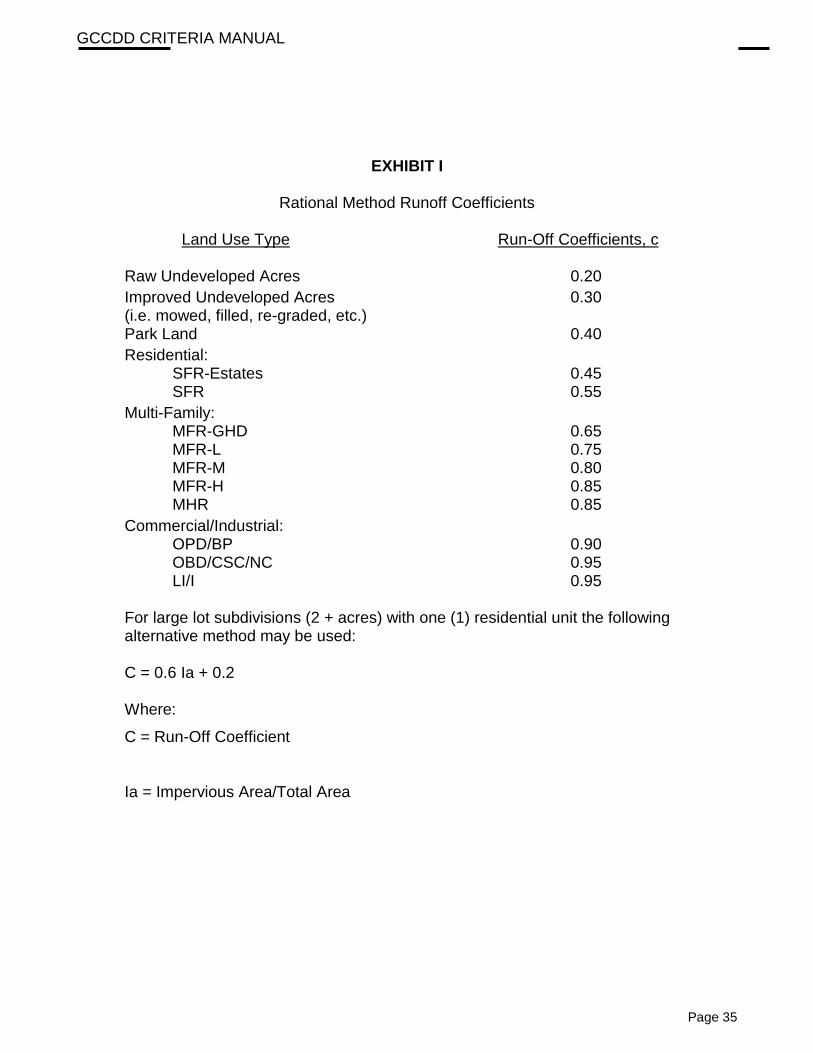
EXHIBIT I
Rational Method Runoff Coefficients
Land Use Type Run-Off Coefficients, c
Raw Undeveloped Acres 0.20
Improved Undeveloped Acres 0.30 (i.e. mowed, filled, re-graded, etc.) Park Land 0.40
Residential: SFR-Estates 0.45 SFR 0.55
Multi-Family: MFR-GHD 0.65 MFR-L 0.75 MFR-M 0.80 MFR-H 0.85 MHR 0.85
Commercial/Industrial: OPD/BP 0.90 OBD/CSC/NC 0.95 LI/I 0.95
For large lot subdivisions (2 + acres) with one (1) residential unit the following alternative method may be used:
C = 0.6 Ia + 0.2 Where:
C = Run-Off Coefficient
Ia = Impervious Area/Total Area

GCCDD CRITERIA MANUAL
Page 36
EXHIBIT II
Rainfall Intensity Coefficients
Coefficient 100-Year 50-Year 25-Year 10-Year 5-Year 3-Year
<= 60 Min B 90.8 107.0 98.5 107.9 92.9 90.6 D 16.5 21.1 24.0 23.6 19.7 19.5 e 0.685 0.734 0.729 0.781 0.788 0.803
> 60 min
b 84.0 86.5 89.2 96.6 70.1 71.0 d 11.0 10.0 10.4 17.2 7.7 8.4 e 0.679 0.709 0.736 0.770 0.752 0.774
Intensity Equation: e
c dt
bI
)( +=

GCCDD CRITERIA MANUAL
Page 37
EXHIBIT III

GCCDD CRITERIA MANUAL
Page 38
APPENDIX A
Signature Block
For Drainage Plans
Approved by the GALVESTON COUNTY CONSOLIDATED DRAINAGE DISTRICT
Director Date
Director Date
This is to certify that the above was signed based on the recommendation of the District’s Engineer having reviewed all sheets provided and found them to be in general compliance with the District’s “Drainage Criteria Manual”. This approval is only valid for three hundred sixty-five (365) calendar days. Please note, this does not necessarily mean that all the calculations provided in these plans have been completely checked and verified. The plans submitted have been prepared, signed, and sealed by a Professional Engineer licensed to practice engineering in the State of Texas, which conveys the engineer’s responsibility and accountability.
APPENDIX A
Signature Block
For Plats
Approved by the GALVESTON COUNTY CONSOLIDATED DRAINAGE DISTRICT
Director Date
Director Date
This is to certify that the above was signed based on the recommendation of the District’s Engineer having reviewed all sheets provided and found them to be in general compliance with the District’s “Drainage Criteria Manual”. This approval is only valid for three hundred sixty-five (365) calendar days. Please note that this does not necessarily mean that the plat has been completely checked and verified. The plat as submitted, was prepared, signed, and sealed by a Professional Land Surveyor licensed to practice surveying in the State of Texas, which conveys responsibility and accountability to that Surveyor.
Approved 07-10-12

GCCDD CRITERIA MANUAL
Page 39
APPENDIX B
Required Plat Notes
1. Buildings, fences or other structures shall not be erected in GALVESTON COUNTY CONSOLIDATED DRAINAGE DISTRICT (the DISTRICT) right-of-ways or drainage easements.
2. The detention and drainage facilities are to be maintained by the property owner. Use this note for private or single lot system only.
3. The detention facility is to be maintained by the DISTRICT provided that the DISTRICT has approved the construction of the facility, the developer has paid the required fee, the site and access has been deeded to the DISTRICT in fee, and subject to approval by the Board.
4. No building permit shall be issued for any lot within this subdivision until a detention and drainage plan has been approved by the DISTRICT.
5. Additional drainage easements may be required at the time a drainage plan is submitted to the DISTRICT for approval.
6. Plantings, flowerbeds or other landscaping is not permitted within side lot drainage or detention easements.
7. No building permit shall be applied for until all drainage and detention facilities are constructed, inspected and approved by the DISTRICT.
8. No permanent improvements including landscaping, paving, trees, sprinklers, utilities, playground equipment, park benches, tables, sport fields, piers, or sidewalks shall be constructed within the detention facility without the approval of the District.
Required Plan Notes
1. Contact the DISTRICT 48 hours prior to commencing construction and upon completion
for the final inspection.
2. Buildings, fences or other structures shall not be erected in the DISTRICT right-of-ways or drainage easements.
3. The detention and drainage facilities are to be maintained by the property owner. Use this note for private or single lot system only.
4. The detention facility is to be maintained by the DISTRICT provided that the DISTRICT has approved the construction of the facility, the developer has paid the required fee, the site and access has been deeded to the DISTRICT in fee, and subject to approval by the Board.
5. All drainage facilities shall have erosion control established upon completion. Contractor to provide the DISTRICT with proposed grass type, application rate, and method for approval prior to commencing. Grass shall be 95% germinated prior to acceptance of the facility.
Approved 07-10-12
GCCDD CRITERIA MANUAL
Page 40
6. Plantings, flowerbeds or other landscaping is not permitted within side lot drainage or detention easements.
7. No building permit shall be applied for until all drainage and detention facilities are constructed, inspected and approved by the DISTRICT.
8. DISTRICT Personnel shall have the right to enter upon the property and conduct interim inspections as required.
9. No permanent improvements including, landscaping, paving, trees, sprinklers, utilities, playground equipment, park benches, tables, sport fields, piers, or sidewalks shall be constructed within the detention facility without the approval of the District.
Approved 07-10-12

GCCDD CRITERIA MANUAL
Page 41
APPENDIX C
Right-of-Ways and Easements
The GALVESTON COUNTY CONSOLIDATED DRAINAGE DISTRICT (the DISTRICT) requires the following minimum Right-of-Way in all developments within its boundaries for drainage work. All dimensions given below for minimum Right-of-Way or easements are from the center of the proposed realigned channel. Reference should be made to the DISTRICT’S Master Drainage Plan for detailed information.
1. Clear Creek Fee Simple Right-of-Way
a. One Hundred Seventy-Five feet (175’). (See latest COE plan.)
2. Chigger Creek Fee Simple Right-of-Way
a. From Clear Creek to FM 518, One Hundred feet (100’).
b. From FM 518 to Windwood Street: Ninety feet (90’).
c. From Windwood Street to the DISTRICT boundary: Seventy feet (70’).
d. All gullies or drainage ditches under the DISTRICT jurisdiction: Fifty feet (50’).
3. Cowards Creek Fee Simple Right-of-Way
a. Clear Creek to Castlewood: One hundred feet (100’).
b. From Castlewood to the DISTRICT boundary: ninety feet (90’).
c. All gullies or drainage ditch under the DISTRICT Jurisdiction: Fifty feet (50’).
4. Mary's Creek Fee Simple Right-of-Way
a. Clear Creek to FM 2351: One hundred feet (100’).
b. FM 2351 to the DISTRICT boundary: Ninety feet (90’). c. All gullies or drainage ditches under the DISTRICT jurisdiction: Fifty feet
(50’).
5. Dickinson Bayou Fee Simple Right-of-Way (Revised on 1/22/2019)
a. Upstream DISTRICT Boundary to American Canal – 250 feet total width, 125 feet per side.
b. American Canal to Downstream DISTRICT Boundary – 400 feet total
width, 200 feet per side.

GCCDD CRITERIA MANUAL
Page 42
c. Box Ditch – 250 feet total width, 125 feet per side.
d. Lundy Ditch – 200 feet total width, 100 feet per side.
e. Madera Ditch – 200 feet total width, 100 feet per side
. f. Coyote Creek – 200 feet total width. 100 feet per side.
g. Your Ditch – 140 feet total width, 70 feet per side.
h. All gullies or drainage ditches under the DISTRICT jurisdiction: Fifty feet (50’).
6. Dickinson Bayou Bypass Fee Simple Right-of-Way. (Revised on 1/22/2019)
a. The DISTRICT Jurisdiction to Dickinson Bayou: 300 feet total width, 150 feet per side.
b. All gullies or drainage ditches under the DISTRICT jurisdiction: Fifty feet (50’).
7. In those cases where the existing top of bank extends beyond the above stated minimums, the right-of-way shall be increased so as to provide at least a thirty foot (30’) maintenance berm adjacent to each ditch.
8. Unobstructed access at least twenty feet (20’) wide shall be provided to all easements
and rights-of-way from a road or street at least every 2000 feet (2000’).
9. Storm sewer easements for outfalls shall be twenty feet (20’) minimum and outside of lot lines.

GCCDD CRITERIA MANUAL
Page 43
APPENDIX D
Variance Request Information Form
PROJECT NAME:
APPLICANT:
DATE SUBMITTED:
SPECIFIC VARIANCE IS BEING SOUGHT AND EXTENT OF VARIANCE:
DRAINAGE CRITERIA MANUAL REFERENCE:
STATEMENT OF FACTS:

GCCDD CRITERIA MANUAL
Page 44
__________________________________
Signature Date
__________________________________
Printed Name
APPENDIX E