GALVESTON BAY ESTUARY PROGRAM - Texas Digital Library
88
1 GALVESTON BAY ESTUARY PROGRAM PLAN REVIEW SUMMARY (1996-2000) January 15, 2001
Transcript of GALVESTON BAY ESTUARY PROGRAM - Texas Digital Library

1
GALVESTON BAY ESTUARY PROGRAM
PLAN REVIEW SUMMARY (1996-2000)
January 15, 2001

2
Table of Contents
Page I. Acronym Page .....................................................................................................................3 II. Background and Introduction .................................................................................... . . . . .6 III. Executive Summary.............................................................................................................9 IV. Plan Review Summaries.
a. Habitat Protection Action Plan..............................................................................11 b. Habitat Protection Action Flowchart (Figure 1) ....................................................19 c. Species Populations Protection Action Plan..........................................................20 d. Species Protection Action Flowchart (Figure 2) ...................................................26 e. Public Health Protection Action Plan....................................................................27 f. Public Health Protection Flowchart (Figure 3)......................................................31 g. Freshwater Inflows and Bay Circulation Action Plan...........................................32 h. Freshwater Inflows and Bay Circulation (Figure 4) ............................................. 37 i. Spills/Dumping Action Plan................................................................................. 38 j. Spills/Dumping Action Flowchart (Figure 5) ........................................................42 k. Shoreline Management Action Plan.................................................................... 43 l. Shoreline Management Action Flowchart (Figure 6) ............................................47 m. Water and Sediment Quality Action Plan. .............................................................48 n. Water and Sediment Quality Action Flowchart (Figure 7) .................................. 54 o. Non-point Sources of Pollution............................................................................ 55 p. Non-point Sources Action Flowchart(Figure 8) ................................................... 65 q. Point Sources of Pollution. .................................................................................. .66 r. Point Sources of Pollution Flowchart (Figure 9) ...................................................71 s. Public Participation and Education Action Plan................................................... 72 t. Research Action Plan........................................................................................... 78
IV APPENDICES
Appendix A: Regional Monitoring Plan. ......................................................................... 81 Appendix B: Plan Partners in Implementation................................................................. 82 Appendix C: Galveston Bay Council and Subcommittee Members .................................90

3
LIST OF ACRONYMS Best Management Practice BMP
Biochemical Oxygen Demand BOD
Bureau of Economic Geology BEG
Beneficial Uses Group BUG666
Clean Water Act CWA
Coastal Wetlands Planning, Protection, and Restoration CWPPRA
Coastal Coordination Council CCC
Coastal Zone Management CZM
Comprehensive Conservation and Management Plan CCMP
Data and Information Management System DIMS
Department of Public Safety DPS
Galveston Bay Estuary Program GBEP
Galveston Bay Foundation GBF
Galveston Bay Freshwater Inflows Group GBFIG
Galveston Bay Information Center GBIC
Galveston County Health District GCHD
Geographic Information System GIS
Gulf Coast Waste Disposal Authority GCWDA
Gulf of Mexico Program GMP
Harris County Flood Control District HCFCD
Harris County Pollution Control Department HCPCD
Harris-Galveston Coastal Subsidence District HGCSD
Houston-Galveston Area Council H-GAC
Houston Lighting and Power HL&P
Houston Ship Channel HSC
Inferometric Synthetic Aperture Radar INSAR
Interagency Co-ordination Team ICT
Light Detection and Ranging LIDAR
Monitoring and Research M&R

4
National Marine Fisheries Service NMFS
National Oceanic and Atmospheric Administration NOAA
National Pollution Discharge Elimination System NPDES
Natural Resources Conservation Service NRCS
Natural Resources Damage Assessment and Restoration NRDA
Natural Resource Uses NRU
Non-5point Source NPS
North American Wetlands Conservation Act NAWCA
Polychlorinated Biphenyls PCB
Public Owned Treatment Works POTW
Public Participation and Education PPE
Quality Assurance Project Plan QAPP
Texas A &M University TAMU
Texas Department of Health TDH
Texas Department of Transportation TxDOT
Texas General Land Office TGLO
Texas Natural Resource Conservation Commission TNRCC
Texas Parks and Wildlife Department TPWD
Texas Water Development Board TWDB
Total Maximum Daily Load TMDL
Texas Marine Advisory Service TMAS
Texas Southern University TSU
Texas State Soil and Water Conservation Board TSSWCB
Total Suspended Solids TSS
U.S. Army Corps of Engineers COE
U.S. Coast Guard USCG
U.S. Department of Agriculture USDA
U.S. Environmental Protection Agency EPA
U.S. Fish and Wildlife Service USFWS
U.S. Geological Survey USGS
Volatile Organic Compounds VOC

5
Water Control Improvement District WCID
Wastewater Treatment Plant WWTP
Water and Sediment Quality WSQ
Work Plan WP

6
Background
The Galveston Bay Estuary Program, formerly the Galveston Bay National Estuary Program, was established in 1989 to develop a comprehensive conservation management plan (CCMP) for the Galveston Bay Ecosystem. The CCMP for the Galveston Bay area is called The Galveston Bay Plan (The Plan). The Plan was developed in three phases over a five year period: Identification and Agreement of Priority Problems; Scientific Characterization of those problems; and Development of Solutions. The Plan outlines a series of goals and links a set of specific initiatives to the identified problems in Galveston Bay. These solutions, which are outlined by Action Plan, were developed over three years by sixteen taskforces. There are 9 main action plans and two support action plans: Habitat Protection, Species Protection, Freshwater Inflow, Shoreline Management, Spills and Dumping, Public Health, Water and Sediment Quality, Non-point Sources of Pollution, Point Sources of Pollution, Public Participation and Education, and Research. On December 14, 1994, the Policy Committee of the Galveston Bay National Estuary Program (GBNEP) voted to accept the final draft of The Galveston Bay Plan for submission to the EPA for final approval. That approval, which came from EPA Administrator Carol Browner in late March 1995 after review of The Plan by 17 federal agencies, signaled the transition from a federal estuary program of research and planning to a state program geared to implementation. The TNRCC, as the state agency responsible for the management of aquatic and marine ecosystems and fo r federal Water Quality Act programs, is the lead agency responsible for administering the Program. The GBEP was jointly managed by TNRCC and TGLO between 1996 and 1998 however; in 1999 the Texas Legislature passed the Texas Estuaries Act and appropriated 1.1 million dollars to the TNRCC to manage the Program and implement The Plan.
Introduction The Galveston Bay Plan was developed and approved for implementation over a 20-year period with incremental reviews every 5 years. FY 2000 marked our first 5 years of implementation. In December 1999 The Plan review process was initiated. This review is to recognize the efforts of our Plan partners, determine the status of implementation for each Action, and identify priority areas to focus implementation efforts over the next five years (2001-2005). The Plan Review was conducted in two phases by task forces made up of the GBEP standing subcommittees (See Appendix C) and additional participants who have been involved in Plan implementation. There were two main taskforces and two support task forces. The Natural Resources Uses Task Force reviewed the Habitat Protection, Shoreline Management, Freshwater Inflow and Circulation, Species Protection, and Spills/Dumping Action Plans. The Water and Sediment Quality Task Force reviewed the Non-point Sources of Pollution, Point Sources of Pollution, Water and Sediment Quality, and Public Health Action Plans. The Public Participation

7
and Education Task Force reviewed the education and outreach needs for increasing awareness of bay issues. The Research Coordination Board evaluated the status of research conducted in the Galveston Bay area and identified research needs for the future. Phase 1 involved collecting information from Plan Partners on implementation activities they had conducted over the past five years. The task forces met several times over a 6-month period to review each Action outlined in The Plan. Additional information was also solicited by phone and mail in order to capture the efforts of as many Plan partners as possible (See Appendix A for List of Plan Partners). The GBEP compiled and organized the information provided and set a series of meetings to determine the status of each step of an Action. Note: If it was not reported, activities and actions taken by some partners may not be listed in this document. Phase 2 involved determining the status of each Action by Step. The task forces reconvened for 4 months and evaluated the status of each Action based on the information provided on implementation. The results of those meetings, which outlines implementation efforts and the status of each Step, is presented in the following segments of this document.
Notes on Organization
The main body of this document is formatted similarly to the existing structure of The Plan. The information is presented by Action Plan, but incorporates the priority problem, the goals, and the objectives identified to address the problem. It is divided into 12 sections: one introductory section; nine sections on main action plans; and 2 section on the support action plans. There are some 82 actions and several hundred steps outlined by Action Plan as noted below. < Habitat Protection Action Plan < Species Populations Protection Action Plan < Public Health Protection Action Plan < Freshwater Inflows and Bay Circulation Action Plan < Spills/Dumping Action Plan < Shoreline Management Action Plan < Water and Sediment Quality Action Plan < Non-point Sources of Pollution < Point Sources of Pollution < Public Participation and Education < Research In each Action Plan listed above, the format and content is standard: The ‘Action Plan Purpose’ is a brief statement describing the intended outcome of the action plan. It sets the overall direction for more specific goals. The ‘Action Plan Flowchart’ is a diagram that provides an overview of the entire Action Plan by tying the Actions to specific priority problems and objectives.

8
The ‘Highlights Summary Paragraphs’ are statements outlining key implementation activities and future needs identified during the review. The ‘Priority Problem’ is a concise statement of the environmental problem to be addressed as outlined in The Plan. There may be more than one priority problem per action plan. The ‘Goals’ are broad, long-term solutions to the problem. There may be more than one goal per problem. The ‘Objective(s)’ are environmental targets toward which future progress toward the goal can be measured. This is more specific and short term than the goal. The ‘Actions’ are specific measures to be taken to reach the objective. There may be more than one action per objective. The ‘Action’ includes the following information:
Action Name and Number: The title of the action.
What: Concise description of the action.
How: The process involved in taken action, described in the form of consecutive steps. It is at this level that the status of implementation is identified. Activities implementing The Plan are also outlined at this level.
Step: The status of each Step is depicted in 1 of 6 ways: (1) initiated and in progress; (2) initiated and complete; (3) not initiated, but to be scheduled in the next five year period; (4) not initiated and not scheduled; (5) not initiated and pending; and (6) no status, insufficient information.

9
Executive Summary There are some 82 Actions outlined in the Galveston Bay Plan. Seventy actions implement the main action plans in the area of habitat/living resource conservation, balanced human uses, and water and sediment quality improvement. Twelve actions implement the support action plans in the areas of public participation and education and research. Great progress has been made in our first five years of implementing the Galveston Bay Plan. Efforts have been initiated on 76 of the 82 Actions identified in The Plan. Some 67% of the steps have been initiated and are in progress; 5% are complete; 29% have not been initiated; and 4% did not have sufficient information reported to make a determination. Habitat is being restored under The Plan’s number one priority Action Plan of Habitat Protection. Some 1000 acres of wetlands have been subject to rehabilitation and even more has been protected through new acquisitions by private organizations. Non-point sources of pollution, the number one water quality problem in Galveston Bay, is being addressed. Local governments are developing storm water management programs; small businesses are implementing voluntary pollution prevention actions; flood control districts are restoring streambanks through revegetation; homeowners are being educating on proper maintenance of septic systems; and more citizens are using bay friendly landscaping techniques. Freshwater inflows needs are being calculated and management strategies identified. Stakeholders are collaborating through a regional approach established under Senate Bill 1. Municipal point source discharges are improving. Small utility districts, who may not have the resources or expertise to operate certain wastewater treatment plants in the most efficient and effective way, are improving due to technical assistance efforts. Species protection efforts for birds have been enhanced. Resources are being leveraged to build additional islands for bird habitat. Although work continues, updated data (EBB and Flow, 2001) show an apparent increase in several bird species, including the brown pelican. Shoreline Management remains a challenge. Actions have been initiated to preserve the integrity of our shorelines, but much work is needed. Under the Coastal Erosion Planning and Response Act, some $15 million in Texas fiscal year 2000 and 2001 were provided for erosion response efforts: focus largely on the Gulf side. Some cities are considering the importance of key wetland habitat along the shoreline, as wetland plans are being developed. However, integrated planning and management will be needed to reconcile the activities of improving public access and expanding recreational opportunities with maintaining shoreline integrity. Public Health is being assessed as Seafood Safety Consumption risks are being evaluated. A bay-wide seafood consumption risk assessment is being conducted. Agencies and local groups established a seafood safety task force to set monitoring protocol and procedures that will provide consistency for future assessments.

10
The Texas Estuaries Act, passed in 1999, recognizes the importance of collaboration in preserving this vital resource. Although the passing of the Act and the efforts of The Plan partners give us reason to believe that the future of Galveston Bay is very promising, it will take the recognition that everyone has a role. Many challenges remain. As population continues to grow, pressure on our natural resources increase. Over the next five years we will continue working to implement issues identified in The Plan; however, priority areas include wetlands planning and restoration, stormwater management, freshwater inflows, invasive species, NPS from marinas and boats, technical assistance for small utilities, seafood safety, and public access.

11
Habitat Protection Action Plan 5-Year Summary
To provide optimal fish and wildlife habitat supporting the Galveston Bay system by effectively regulating wetland habitat to preclude net losses; conserving habitat through public ownership or control; implementing habitat creation, restoration, and improvement programs; reducing the adverse impacts from dredging and filling; and ensuring management practices that maximize beneficial uses of dredged material. The Habitat Protection Action Plan Priority Problems, Goals, Objectives and Action Items are shown in Figure 1 (p.19).
Highlights Galveston Bay Plan partners have completed or are in the process of completing many habitat conservation, protection and restoration efforts throughout the Galveston Bay system, comprising thousands of acres. The U.S. Fish and Wildlife Service’s National Coastal Wetlands Conservation Grants, North American Wetlands Conservation Act (NAWCA) grants, and Texas General Land Office’s Coastal Erosion Protection and Restoration Act (CEPRA) program have provided major sources of funding for restoration efforts along the coast. The partnering of federal funding, corporate and non-profit contributions, and, state and local matching funds have greatly assisted restoration efforts throughout Galveston Bay. The Galveston Island State Park, San Jacinto State Park, Christmas Bay Shoreline Protection, Clear Creek Beneficial Use Project, Pierce Marsh Restoration and Acquisition, Scenic Galveston’s Estuarial Corridor Acquisition and Restoration, and the Dollar Bay Marsh and Prairie Acquisition are examples of these projects. Projects associated with the deepening and widening of the Houston Ship Channel include the construction of a 200 acre demonstration marsh (Atkinson Island), an 800 acre beneficial use marsh (Bolivar), and a six acre bird nesting island. Over the life of the project, more than 4,000 acres of wetlands will have been created. Techniques are being developed to restore and protect seagrass beds throughout Galveston Bay. Seagrass meadows are the most valuable and most diminished habitat (by percent) type in the Galveston Bay system. Several wetland restoration and protection projects will begin construction in 2001. They include activities at: Halls Lake, Jumbile Cove, Little Cedar Bayou, Delehide Cove , North Deer Island, Omega Bay and Moses Lake Shoreline. For a more complete list of Habitat Protection projects, visit the GBEP website at http://survey.tamug.tamu.edu/gbay/HP_Projects.asp or the USFWS website at http://ifw2es.fws.gov/clearlaketexas/texascoastalprogram . Several documents have increased coordination among federal, state and local entities, and have increased leveraging of funds. GBF assembled the Habitat Conservation Blueprint, a document that identifies more than 170 potential restoration or conservation sites. The Blueprint is being used to coordinate and focus restoration efforts. The Texas Coastal Wetlands Guidebook identifies 111 wetland sites that are available to the general public. The Guidebook, produced by

12
Texas Parks and Wildlife Department and Sea Grant, can be used to target educational and protection efforts. The increased coordination and development of innovative habitat restoration techniques places Galveston Bay’s conservation projects at the forefront of wetlands restoration nationally. PRIORITY PROBLEM I Lost or degraded aquatic habitats: Vital Galveston Bay habitats have been lost or reduced in quality by a range of human activities, threatening the bay’s future sustained productivity. Habitat loss has resulted from various processes including subsidence, erosion, conversion to agriculture, urban development, and dredging and filling activities. GOAL 1. Expand areas and restore quality of wetland habitats. Increase the quantity and improve the quality of wetlands and habitat for fish and wildlife in the Galveston Bay system. Objective A. Create or restore 15,000 acres of vegetated wetlands within 10 years. Specific targets include : a) 1,400 acres of submerged aquatic vegetation; b) 5,000 acres of freshwater marsh; and c) 8,600 acres of estuarine emergent marsh. Action HP-1: Restore, create, and protect wetlands What: Implement a wetland habitat restoration, creation and enhancement program to create or restore 15,000 acres of vegetated marine, estuarine, and shoreline wetlands within 10 years. Specific targets: a) 1,400 acres of submerged aquatic vegetation; b) 5,000 acres of fresh marsh; and c) 8,600 acres of estuarine emergent marsh. Step 1. Status: this step has been initiated and is in progress. Galveston Bay partners have developed numerous past, present, and future efforts to create, restore, and protect wetlands. TPW, NRDA, TGLO, USFWS, and NOAA, supported by GBEP, GBF, and others are currently involved in projects to restore, create, and protect wetlands. GBEP partners identify priority projects and take advantage of funding opportunities as resources allow. Step 2. Status: this step has been initiated and is in progress. TPW and TGLO are pursuing means of protecting high quality wetlands. Christmas Bay, Texas became the first coastal reserve. A management plan for Christmas Bay has been approved by TPW, and is under review for approval by TGLO. Pilot prop-free zones have been created in Redfish Bay and the Laguna Madre. Submerged aquatic beds are being restored in West Bay using transplant stock from Christmas Bay and Laguna Madre. Step 3. Status: this step has been initiated and is in progress. Public outreach and education have begun through a variety of venues. GBF’s Bay Day and Marsh Mania, the annual Coastal Issues Conference, the biennial Galveston Bay Symposium, Sea Grant, and the Coastal Wetlands Center efforts have all increased knowledge of habitat conservation practices. Step 4. Status: this step has been initiated and is in progress. Evaluations of marsh and seagrass creation and restoration techniques are ongoing. GBEP, NMFS, and USFWS have
13
seagrass restoration studies underway. In 1998,TGLO and UT Bureau of Economic Geology evaluated marsh creation and restoration projects in Galveston and Trinity Bay systems. USGS is currently evaluating the use of INSAR (Inferometric Synthetic Aperture Radar) technology to accurately assess and plan wetland restoration. The Bureau of Economic Geology is conducting a shoreline retreat study. Action HP-2: Promote beneficial uses of dredged material to restore and create wetlands. What: Develop a beneficial uses program for dredged material which 1) includes viable mechanisms for funding added costs of handling and processing material; and 2) encourages the beneficial disposal of dredged material. Step 1. Status: this step has been initiated and is in progress. The COE has established an Interagency Coordination Team (ICT) modeled on the Beneficial Uses Group (BUG) for the Port of Houston Ship Channel Expansion Project. The ICT generally meets once a month. Other dredged material management plans are prepared on a project-by-project basis. Step 2. Status: this step has not been initiated, but activities will be scheduled between 2001 and 2005. The ICT has not developed a comprehensive bay-wide beneficial uses management plan or inventory for the Galveston Bay estuary. Step 3. Status: this step has been initiated and is in progress. The Port of Houston monitors dredged materials beneficial use sites for the Houston Ship Channel expansion project under an arrangement with the COE. Approximately 4,500 acres of new wetlands and bird islands will be created from the 50-year Houston Ship Channel Project. Step 4. Status: this step has been initiated and is in progress. The COE continues to seek additional funding to meet federal consistency and management plan criteria in the dredge material planning process. Objective B. Restore natural functions and values to 50% of degraded wetlands within 20 years.
Action HP-3: Inventory degraded wetlands and fund remedial measures. What: Inventory degraded wetlands, identify the causes of deterioration, and fund remedial measures for restoration of 20 percent of degraded wetlands within 20 years. Such measures will include re-establishing sediment sources, restoring hydrology, and others as appropriate. Step 1. Status: this step has not been initiated and is not scheduled. A definition of degraded wetlands may not be needed as remedial measures to these wetlands are undertaken. Step 2. Status: this step has been initiated and is in progress. Efforts to inventory habitat have been made. GBF published the Habitat Conservation Blueprint, which includes impacted wetlands in its inventory. However, degraded habitats have not been ranked, per se. Several entities are working to refine the Habitat Conservation Blueprint, and to identify and evaluate

14
restoration sites. NMFS compiled a list of restoration sites in 1990-1992 and is in the process of transferring the data into the HGAC data clearinghouse. NMFS published the data as part of a report entitled Decision Analysis Series, from the NOAA Coastal Ocean Program. NMFS updates the compilation as new information is provided. COE compiled a mitigation site list. The list is not current, however. Step 3. Status: this step has been initiated and is in progress. GBF hosted a “Lessons Learned Workshop” on marsh restoration techniques. Marsh restoration and creation is a learning experience. As more projects are completed, the knowledge base on which techniques are effective and which are not is expanded. GOAL 2. Halt the conversion of wetlands to other uses. Eliminate or mitigate the conversion of wetlands to other uses caused by human activities. Objective C. Sustain no net loss of existing wetland areas. HP-4: Implement a coordinated system-wide wetland regulatory strategy. What: Implement a coordinated and effective system-wide habitat regulatory program to 1) minimize licensing uncertainty; 2) provide for appropriate mitigation and monitoring by the permitees; 3) standardize mitigation guidelines/criteria; 4) provide for expanded enforcement oversight and improved enforcement by regulators; and 5) eliminate federal economic support for activities not meeting consistency criteria. Step 1. Status: this step has been initiated and is complete. TNRCC issued a guidance document and developed guidelines for 401 certification. Standards are revised every 3 years. Step 2. Status: this step has been initiated and is in progress. TGLO and other agencies formed PAG (Permit Assistance Group). EPA has been examining effectiveness of mitigation for Section 404 permits (EPA/COE ). National Wildlife Federation has also been looking at this issue. TNRCC Guidelines/COE Interagency Guidelines to Applicants address most mitigation issues. TGLO/BEG 1998 study. GBF’s Wetland Permit Review Committee meets monthly to generate comments for permit applications. Local government involvement in an important but untapped tool. Step 3. Status: this step has not been initiated. The EPA has not received adequate funding to fully pursue advanced identification as a regulatory tool. Landowners opposed early attempts at advanced identification. The EPA plans to develop this process as a regulatory tool in the future. Step 4. Status: this step has not been initiated, but activities will be scheduled between 2001 and 2005. No information was provided concerning the evaluation of flood management policies with respect to consideration of habitat protection. GOAL 3.

15
Acquire Existing Wetlands and Encourage Conservation. Acquire existing wetland habitats and provide economic incentives for conservation. Placing wetland areas in permanently protected status will ensure future contributions from these areas for support of plant, fish, and wildlife species. Objective D Place 50,000 acres of wetland and flood plain habitats in public ownership over the next 20 years. Action HP-5: Acquire and protect quality wetlands. What: Identify highest priority aquatic wetlands throughout the watershed which can be protected by public ownership or through permanently protected status by private entities. Expand state and federal programs to acquire 1) these high priority tracts; 2) other tracts of habitat and non-developmental easements; 3) smaller blocks of habitat; and 4) non-traditional areas such as wading bird and fisheries habitats. Encourage habitat acquisition by private conservation organizations and voluntary conservation programs by land owners. Step 1. Status: this step has been initiated and is in progress. A Coastal Wetlands Acquisition Plan for Texas (1995), jointly developed by the TPW/GLO, identifies and ranks general coastal wetland categories by region for acquisition. It also creates the criteria and guidance for identifying and prioritizing coastal wetlands for state acquisition. It is meant to complement existing wetland preservation programs. The plan includes a section that identifies current and potential funding sources for acquisition Step 2. Status: this step has been initiated and is in progress. Individual agencies, land trusts, etc., have their own acquisition interests, priorities, and methods. GBEP may consider combining them, but this information could, some think, be used to inflate land costs and thereby impact the ability to acquire wetland properties. The Habitat Conservation Blueprint includes sites for which acquisition has been recommended.. Step 3. Status: this step has been initiated and is in progress. Joint acquisition and management efforts are underway by federal and state agencies and non-profit organizations. The partnership between GBF and the Texas Nature Conservancy made the Pierce Marsh acquisition and protection project possible. Step 4. Status: this step has been initiated and is in progress. Land for the Trinity River Wildlife Refuge was acquired with funding from Land and Water Conservation Fund and Migratory Bird Conservation Fund (duck stamps). The refuge was created as a result of efforts by Liberty County citizens. Step 5. Status: this step has been initiated and is in progress. The COE acquired land as part of the Wallisville Lake Management Plan, and will continue to manage the area. The COE transferred ownership of Champion Lake, part of the lake management plan area, to USFWS. Objective E. Develop economic incentives that would encourage landowners to protect wetlands from development.
16
HP-6: Develop economic and tax incentive programs to protect wetlands. What: Develop and implement an ad valorem tax incentive and development disincentive program to be administered by a local government entity. Heighten awareness of existing economic incentives that would encourage aquatic habitat protection to ensure that people are not taxed for highest and best use for property. Seek to put into place a “Wetlands Exemption” (like an agricultural exemption), thereby reducing tax liability for leaving wetlands in their natural state. Step 1. Status: this step has not been initiated, but activities will be scheduled between 2001 and 2005. Step 2. Status: this step has not been initiated, but activities will be scheduled between 2001 and 2005. There is an exemption for Wildlife Management within the Agricultural Exemption program. This primarily involves converting agricultural exemption to wildlife use. Step 3. Status: this step has not been initiated, but activities will be scheduled between 2001 and 2005. Currently, state and federal programs are accomplishing these steps. GOAL 4. Restore and create colonial bird nesting sites. Restore deteriorated colonial bird nesting sites and create new islands where nesting habitat is inadequate. Objective F. Improve and protect habitat on major colonial bird nesting sites of the Galveston Bay system. HP-7: Facilitate bird nesting on existing sites. What: Induce more intensive and dependable bird use of existing islands by regrading the islands to maintain minimum required elevations above sea level, managing the vegetation, and placing signs warning people to stay away from these islands, particularly during the nesting season. Step 1. Status: this step has been initiated and is in progress. Public education signs have been put out to discourage public use of islands during nesting seasons. Step 2. Status: this step has been initiated and is in progress. Beneficial Uses Group (BUG) projects include some bird island projects. Two have been created, and two more are proposed. GBEP partners are developing projects that include bird nesting islands. Progress is being made on several fronts, however some sites have been lost. Step 3. Status: this step has been initiated and is in progress. TPW has worked to improve enforcement of existing laws and public awareness of the laws. TPW published a booklet on nuisance colonial bird nesting sites for urban areas.

17
Step 4. Status: this step has been initiated and is in progress. TPW has explored and promoted the use of Section 1135 and Section 204 funds. Actions in Step 5 are meeting with such success that these funds have not been fully utilized. Step 5. Status: this step has been initiated and is in progress. Partnerships exist with Audubon Society for restoration, protection, and creation of bird nesting islands. Because of the success of this Step, Step 4 is less than fully utilized. Objective G. Create two additional bird nesting islands within 10 years. Action HP-8: Build nesting islands using dredged materials. The dredged material has been appropriately tested for hazardous substances and pollutants prior to being used for habitat restoration. What: Use dredged material from public or private activities to build islands at a location and of a size amenable to colonization, and where there is a demonstrated need (i.e., underutilized feeding habitat). Step 1. Status: this step has been initiated and is in progress. See HP-7, Step 4. Step 2. Status: this step has been initiated and is in progress. See HP-7, Step 2. Step 3. Status: this step has been initiated and is in progress. See HP-7, Step 4. Step 4. Status: this step has been initiated and is in progress. See HP-7, Step 5. PRIORITY PROBLEM II High erosion rates and loss of vegetation. Some bay shorelines are subject to high rates of erosion and loss of stabilizing vegetation due to past subsidence/sea leve l rise and current human impacts. GOAL 5. Selectively moderate erosional impacts. Selectively moderate erosional impacts to the bay and associated shorelines. Objective H. Adopt a coordinated ecosystem approach to reduce erosional losses of wetlands and habitats in the Galveston Bay system. HP-9: Reduce erosional impacts on wetlands and habitats. What: Establish an integrated bay-wide erosion management program to develop, apply and publicize methods for erosion prevention for wetlands and bay habitats. Step 1. Status: This step has been initiated and is in progress. HGCSD is managing subsidence. While the subsidence issue is considered largely resolved in the Harris/Galveston area, there is

18
new information which indicates it may still be very much a problem in other areas. It is suggested that Christmas Bay may subside 6 inches in the next 25 years from groundwater withdrawals in the Pearland/Brazoria area. USFWS/USGS are doing an INSAR study on subsidence. Step 2. Status: this step has been initiated and is in progress. TGLO contracted with BEG to conduct a baseline LIDAR survey of Texas bays and estuaries. Step 3. Status: This step has been initiated and is in progress. Nonstructural methods have been used to prevent erosion. There have been many shoreline plantings of marsh grass throughout the Galveston Bay area. Step 4. Status: this step has been initiated and is in progress. TGLO’s CEPRA program supports consideration of “soft” alternatives for erosion response. Texas CCMP encourages nonstructural shoreline management through their grant program. Step 5. Status: this step has not been initiated and is not scheduled. The effects of sand and gravel mining on erosion have not been studied. Step 6. Status: this step has not been initiated, but activities will be scheduled between 2001 and 2005. Efforts have been made to reduce erosion in sensitive areas of the bay. USFWS installed articulated stainless steel matting in Christmas Bay to stabilize vulnerable areas of shoreline.

19
FIGURE 1

20
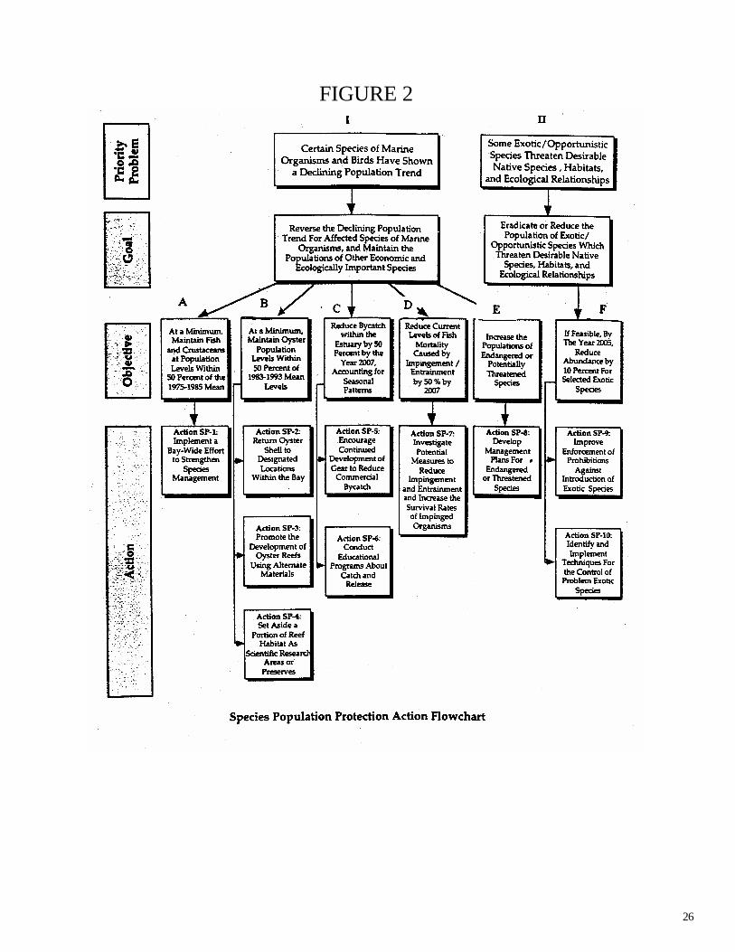
Species Population Protection Action Plan 5-Year Summary
To assure the conservation, restoration, and enhancement of the total natural community of living species in Galveston Bay, both for the maintenance of balanced, indigenous populations which determine overall ecosystem health, and for the long-term vitality of human recreational and economic activities which depend on these renewable living resources. The Species Population Protection Priority Problems, Goals, Objectives and Action Items are shown in Figure 2 (p.26).
Highlights Coordinated, coast-wide efforts have been made to manage species. However, few efforts have focused specifically on the Galveston Bay area. Several individual projects have created oyster reefs including the Fly Ash Project, which featured use of alternate materials, the East Galveston Bay Reef Project, and the Dickinson Bayou Oyster Reef Project, which returned oyster shell to the Bay. Oyster populations are still vulnerable as an economically harvested species, however. TGLO is reviewing the economics of its oyster leasing program, and has placed a moratorium on new oyster leases. GBF’s Oyster Gardening is raising public awareness of the role of oysters in the Galveston Bay ecosystem. Agencies within the Interagency Coordination Team have conducted studies to evaluate the effects of phytoplankton declines, subsidence, channelization, and bay circulation patterns on oyster populations and reef locations. For a more complete list of Species Population Protection projects, visit the GBEP website at http://gbep.tamug.tamu.edu/hpx.html. PRIORITY PROBLEM I Certain species of marine organisms and birds (such as blue crab and birds classified as wading marsh feeders) have shown a declining population trend, with the primary suspected causes identified as loss of habitat, fishing, impingement, and other types of human intervention. Because species within the estuarine environment are dependent on one another for maintenance of the food chain, the preservation of species populations is critical to the ecological and economic health of the Galveston Bay system. GOAL 1. Reverse the declining population trend for affected species of marine organisms, and maintain the populations of other economically and ecologically important species.

21
Objective A. At a minimum, maintain fish and crustaceans at population levels within 50 percent of the 1975-1985 mean. Action SP-1: Implement a bay-wide effort to strengthen species management. What: Implement a bay-wide effort to strengthen species management and protect biological diversity, including better coordination with state programs concerned with species management. Step 1. Status: this step has not been initiated, but activities will be scheduled between 2001 and 2005. The Species Advisory Committee for Galveston Bay has not been formed. Step 2. Status: this step has not been initiated, but activities may be scheduled between 2001 and 2005. TPWD participates in state shrimp, crab, finfish, artificial reef, and oyster advisory groups. However, there is no representative from the Galveston Bay Species Advisory Group, as it has not yet been formed. Other Activities Related to Objective A. TPWD limits the number of commercial licenses issued for several species. Objective B. At a minimum, maintain oyster population levels within 50 percent of 1983-1993 mean levels. Action SP-2: Return oyster shell to designated locations within the bay. What: Develop regulations and operate a program which results in oyster shell being returned to designated locations within the bay, in order to encourage the creation of additional reef acreage. Step 1. Status: this step has not been initiated; funding constraints limit implementation. No steps have been taken to recover spent oyster shell and return it to the bay. Legally, oyster shell belongs to the State of Texas. In practice, oyster fishermen assume ownership of the shell, and sell it. The State of Texas has no program to recover the shell. Regulations requiring the retention of spent shell exist, but TPWD has no funding to develop an enforcement program. TPWD examined what other states were doing with regards to the recovery of shell stock, and prepared a white paper to report on findings. Action SP-3: Promote the development of oyster reefs using alternate materials. What: Continue and expand programs which promote the development of oyster reefs using alternate materials. Step 1. Status: this step has been initiated and is in progress. Reliant Energy created an oyster reef using alternate materials (fly ash) as substrate.

22
Step 2. Status: this step has not been initiated; funding constraints limit implementation. Funding has not been available to TPWD or USFWS to identify potential reef substrate materials. Step 3. Status: this step has been initiated and is in progress. TGLO is reviewing all of its leasing programs, including leasing for oyster reef creation, in an effort to streamline the process. Action SP-4: Set aside a portion of reef habitat as scientific research areas or preserves. What: Set aside a portion of reef habitat as scientific research areas or preserves. The ecology of reef growth and adaptation in the Galveston Bay Estuary requires further study. The creation of new reef habitat offers an excellent opportunity for study of oyster reef accretion and growth processes. Step 1. Status: this step has not been initiated. TPWD has the authority to designate reef habitat areas as research areas, but nothing has been done in the Galveston Bay area. The HL&P Fly Ash Reef and April Fool Reef have been used for research. GBF will create two small reefs in 2001, and will encourage their use as research sites. Objective C. Reduce bycatch within the estuary by 50 percent by the year 2007, accounting for seasonal patterns. Action SP-5: Encourage continued development of gear to reduce commercial bycatch. What: Encourage continued development of gear and devices to reduce bycatch, and recommend the use of gear and/or devices that can be shown to be technically and economically feasible and that can significantly reduce bycatch. Step 1. Status: this step has been initiated and is in progress. TPWD is promoting bycatch education programs. TPWD is translating the 2001 commercial fishing and shrimping regulations, which include the installation of Bycatch Reduction Devices (BRD) and Turtle Exclusion Devices (TED) in some instances, into Vietnamese, conducting workshops, and producing literature on aquatic resources in Galveston Bay to inform Asian-American fishermen of the regulations and their rationale. Step 2. Status: this step has been initiated and is in progress. TPWD conducts annual studies to evaluate the effectiveness of bycatch reduction devices. As of September 1, 2000, new shrimp trawl regulations are in place requiring the installation and use of by catch reduction devices in bay shrimp trawls. There may be some bycatch reduction as TPWD retires commercial licenses. Additionally, TPWD has reclassified some areas of the bay from “open” to “restricted”. As a result, many areas in the Galveston Bay are limited to bait shrimping only, further reducing by catch. Action SP-6: Conduct educational programs about catch and release

23
What: Conduct educational programs about catch and release (including enhancement of survival rates of released fish) targeted at recreational fishermen. Step 1. Status: this step has been initiated and is in progress. TPWD produces literature on catch-and-release fishing. The literature is distributed state wide, including the Galveston Bay area. Step 2. Status: this step has been initiated and is in progress. TPWD has an angler education section that conducts educational programs about catch-and-release fishing and certifies instructors. Objective D. Reduce current levels of fish mortality caused by impingement/entrainment by 50 percent by 2007. Action SP-7: Investigate potential measures to reduce impingement and entrainment and increase the survival rates of impinged organisms. What: Investigate potential measures to reduce impingement and entrainment and increase survival rates of impinged and entrained organisms at power generation stations which utilize bay water for cooling. Step 1. Status: this step has been initiated and is in progress. Reliant Energy completed feasibility studies of new technologies including net exclusion technology and airlift pump systems, but determined the technologies to be impracticable in Galveston Bay applications. Reliant monitors the development of new technologies nationwide, but impingement and entrainment technology has not advanced in recent years. Reliant works with other utility companies to review and comment on new technologies. The Species Advisory Committee and the Research Coordination Board will review past, current, and future impingement research. Step 2. Status: this step has been initiated and is in progress. Reliant Energy has identified new methods for reducing impingement. The practice of running circulator pumps discontinuously has apparently resulted in a decrease in fish mortality, although the decrease has not been quantified. The practice was proven to be economical. Reliant also works with other utility companies to review and comment on new technologies. Step 3. Status: this step has been initiated and is in progress. Reliant Energy monitors the development of EPA regulations establishing plant intake design standards. Step 4. Status: This step has not been initiated, but activities may be scheduled between 2001 and 2005. New EPA intake design standards regulations should be in place in 2001-2002. Reliant Energy will comply with the new regulations. Objective E. Increase the populations of endangered or potentially threatened species. Action SP-8: Develop management plans for endangered or threatened species.

24
What: Develop management plans for the diamondback terrapin and other endangered, threatened, candidate species, or other species of concern. Adopt management plans already in place for sea turtles and other endangered species. Step 1. Status: this step has been initiated and is in progress. TPWD compiled a list of threatened/endangered species. Step 2. Status: this step has been initiated and is in progress. The State of Texas adopted a management plan developed by NMFS for endangered species, specifically sea turtles.. Step 3. Status: this step has not been initiated, but activities may be scheduled between 2001 and 2005. No steps to implement endangered/threatened species plans were identified in the Plan Review process. PRIORITY PROBLEM II Some exotic/opportunistic species (like nutria, grass carp, and fire ants) threaten desirable native species, habitats, and ecological relationships. Significant populations of nutria, a large beaver-like rodent which strips vegetation within freshwater and brackish water marshland, and grass carp, which strips aquatic vegetation, have been reported in the Trinity and San Jacinto portions of the estuary. The encroachment of fire ants into the estuarine ecosystem poses an increasing threat to nesting bird populations. The development of faster cargo ships and increased worldwide trade has heightened the potential for introductions of harmful species. GOAL 2. Eradicate or reduce the population of exotic/opportunistic species which threaten desirable native species, habitats, and ecological relationships. Prevent the introduction of additional exotic species. Objective F. If feasible, by the year 2005, reduce abundance of selected exotic species, including nutria and grass carp. Action SP-9: Improve enforcement of prohibitions against the introduction of exotic species. What: Identify appropriate legislation which regulates the introduction of exotic species, and use available tools to improve the enforcement of prohibitions against the importation of exotic species. Step 1. Status: this step has been initiated and is in progress. Federal law prohibits introduction of non-indigenous species to United States territory, and state law prohibits introduction of non-indigenous species to Texas. Effective enforcement remains a challenge. Step 2. Status: this step has been initiated and is in progress. TPWD and USFWS disseminate information regarding exotic species regulations. GBEP co-sponsored the Ballast Water Workshop in April 2000 at the Port of Houston. Step 3. Status: this step has been initiated and is in progress. Enforcement officials are hired and trained to improve enforcement of exotic species regulations

25
Step 4. Status: this step has been initiated and is in progress. Federal regulations are being proposed to prohibit the discharge of bilge (ballast) water within the Galveston Bay system. Action SP-10: Identify and implement techniques for the control of problem of exotic species. What: Identify and implement effective techniques for the control of problem exotic species populations, such as nutria, grass carp, and fire ants. Within the Galveston Bay Estuary, the introduction and proliferation of exotic opportunistic species such as nutria, grass carp and fire ants have contributed to the degradation of some portions of the estuarine habitat. Step 1. Status: this step has been initiated and is in progress. TPWD has developed some techniques for the control of exotic species such as giant Salvinia. Step 2. Status: this step has been initiated and is in progress. GBF is developing a project to investigate and test grass carp control methods. Step 3. Status: this step has been initiated and is in progress. TPWD is expanding successful programs to control populations of exotic species. Other Activities Related to Objective F. The impacts and threats to the region from exotic species are being addressed, both locally and regionally. However, these efforts are generally piecemeal and are not coordinated on any statewide level as known.
26
FIGURE 2

27
Public Health Action Plan 5-year Summary
To maintain and enhance the Galveston Bay environment to ensure that seafood produced is safe for human consumption and water quality is safe for contact recreation.
The Public Health Action Plan Priority Problems, Goals, Objectives and Action Items are shown in Figure 3 (p.31).
Highlights
Maintenance of adequate public health standards for estuarine seafood is important for protection of the general public, and is also critical for the long-term viability of the fishing industry. Initiatives for public health protection include Risk Management, a Shellfish Sanitation Program, and a Contact Recreation Advisory Program. TDH has received funds from various agencies to analyze fish and crab tissue samples from several locations within the Galveston Bay system, producing a comprehensive “full-scan” analysis and Health Consultation for the Galveston Bay System. As a part of this coordinated effort, standard approach methodologies have been established for a Seafood Consumption Safety Program. However, continued monitoring is needed to ensure regular updates of advisories and the status of seafood safety. Increasing monitoring would produce more data that could allow for better refinement of closures and advisories. Although a recreational program was noted as an important issue, mechanisms for establishing such a program have not been established. No agency has full authority to establish an advisory program. PRIORITY PROBLEM I Seafood from some areas may pose a public health risk due to the potential presence of toxic substances. GOAL 1. Reduce potential health risk resulting from consumption of seafood contaminated with toxic substances. Objective A. Reduce the risk of consumption of Galveston Bay seafood containing tissue
concentrations of toxic substances above risk level standards established by the TDH. Action PH-1: Develop a seafood consumption safety program. Step 1. Status: this step has been initiated and is in progress. Through coordinated work under Plan implementation, a “standard approach” has been developed with regard to methodologies and toxicological approaches in lieu of the standards for selected metals and organic compounds that were originally stated in The Plan. Over the past two years, several sources of funding, including: GBEP, the EPA “Childrens’ Uses” fund, and TNRCC’s TMDL funding, have provided for development of the first bay-wide seafood risk assessment. One of the results of this effort has been development of a standard approach for assessing seafood, which will provide a good baseline for future assessments. TDH does not currently have the funding to

28
institutionalize the program, but needs for future assessments will be recommended by TDH. Long term commitments are needed to track the trends seafood safety and provide sufficient data to keep the public informed. Step 2. Status: this step has been initiated and is in progress. Funding for the recent assessment, described in Step 1., above was provided by state and federal sources; however, a permanent and consistent source of funding has not been provided. Step 3. Status: this step has been initiated and is in progress. The TDH has established a monitoring program for seafood safety in Galveston Bay as noted in step 1; however, long-term implementation is uncertain due to funding limitations. A GBEP Seafood Task Force was developed to facilitate stakeholder and agency involvement in the GBEP’s Seafood Safety Project, which is being used as part of the monitoring program. TDH received funds from TNRCC, GBEP, and EPA to analyze fish and crab tissue samples from several locations within Galveston Bay including: the Houston Ship Channel, Clear Lake, Galveston, Trinity, East, West, Bastrop, Christmas and Drum Bays. The combination of GBEP’s coordination and TDH’s leadership in the 1999-2000 project efforts is producing a comprehensive “full-scan” analysis and Health Consultation for the Galveston Bay System, scheduled to be completed in December, 2000. Step 4. Status: this step has not been initiated and is not scheduled. Actions under WSQ, PS and NPS, incorporates efforts to identify and eliminate contaminant sources, which addresses this step. PRIORITY PROBLEM II About half of the Bay is permanently or provisionally closed to the taking of shellfish. GOAL 2. Reduce oyster reef harvest closures. Objective B. Increase oyster reef areas open to harvest. Action PH-2: Enhance TDH Shellfish Sanitation Program
Step 1. Status: this step has been initiated and is in progress. As a part of the Regional Monitoring Program, TDH continues to sample in excess of requirements of the National Shellfish Sanitation Program 5-20samples/year. Sampling is conducted year round with increased frequency during the summer months. TDH has not received any additional funding for fecal coliform sampling, which is needed to further evaluate shellfish closures. All additional funds have been allocated towards the Vibrio study. As a result, TDH has established a routine monitoring program for Vibrio vulnificus and Vibrio parahaemolyeticus. TDH has also begun working with various groups to education the public concerning the risks of shellfish consumption. The National Interstate Shellfish Sanitation Conference and the Gulf of Mexico Program are two groups working on this issue. States are working together to address the education priorities. Each state will be required to have an education program, and some funding is expected to help implement the programs.

29
PRIORITY PROBLEM III Some tributaries and near-shore areas are not safe for contact recreation due to risk of bacterial infection. GOAL 3. Minimize risk of water-borne illness resulting from contact recreation. Objective C. Establish a contact recreational advisory program. Action PH-3: Develop a contact recreation advisory program. Step 1. Status: this step has not been initiated and is not scheduled. No state agency has legal authority to carry out routine risk management action. TDH has does not have regulatory authority to issue routine advisories. Public Health Emergency Advisories can be issued under the Commissioner of Health’s authority if there is an Emergency situation. This authority is narrow in scope. For example, if there is a sewage break near a swimming hole, an emergency advisory may be posted. Step 2. Status: this step has not been initiated and is not scheduled. TDH has not increased the frequency of monitoring in high-use areas; however, a Beach Monitoring Program was initiated by the General Land Office to implement a water sampling program and notification process with 6 county governments on the Texas coast. This program will begin in the fall of 2000 in coordination with the TNRCC and the TDH. Initial funding for the program is being provided by the Coastal Management Program. Also, see Step 1, above. Step 3. Status: this step has not been initiated and is not scheduled. There has been no increase in the frequency of monitoring in high-use areas. Step 4. Status: this step has not been initiated and is not scheduled. “Unsafe” areas are not being “closed”; however, efforts have been made to provide more information on water quality in high recreational areas. The H-GAC developed a video to educate the public on water quality issues and to assist them in making informed decisions about their use of waterbodies in the area. Several attempts have been made to secure grant funds for Bay area to provide water quality data to the public on- line. Also, see Step 1, above. Step 5. Status: this step has not been initiated and is not scheduled. TNRCC has incorporated into the Texas Surface Water Quality Standards (30TAC307) recommendations from an bacterial indicator study which advised replacement of the traditional bacterial indicator, fecal coliform, with E. coli for freshwater and Enterococci for saltwater. These criteria revisions for contact recreation use have been adopted by the TNRCC. However, TNRCC cannot use the new criteria for designated use screening until EPA approves the revised standards. For more information refer to the following website:
http://www.tnrcc.state.tx.us/water/quality/standards/98055_307.pdf

30
FIGURE 3

31
Freshwater Inflow and Bay Circulation Action Plan 5-Year Summary
To ensure beneficial freshwater inflows necessary for a salinity, nutrient, and sediment loading regime adequate to maintain productivity of economically important and ecologically characteristic species in Galveston Bay. The Freshwater Inflow Action Plan Priority Problems, Goals, Objectives and Action Items are shown in Figure 4 (p.37).
Highlights Annual freshwater inflow needs for Galveston Bay have been incorporated in the Region H Water Planning Group draft regional water plan. However, continued monitoring, modeling, evaluation of temporal and spatial distribution of inflows, and management strategies are needed. The Galveston Bay Freshwater Inflow Group (GBFIG) will continue to serve as the coordinating body for addressing freshwater inflow needs, working closely with Region H and the Galveston Bay Council. Coordination across regions and representation of all impacted parties is crucial in developing management strategies. For a more complete list of Freshwater Inflow projects, visit the GBEP website at http://gbep.tamug.tamu.edu/fix.html PRIORITY PROBLEM I Future demands for fresh water and alterations to circulation may seriously affect productivity and overall ecosystem health. GOAL 1. Ensure beneficial freshwater inflows necessary for a salinity, nutrient, and sediment loading regime adequate to maintain productivity of the estuary. Objective A. Determine annual and seasonal inflow needs to the Bay by 1995. Action FW-1: Complete current studies to determine freshwater inflow needs for the bay
What: Complete current studies to better determine freshwater inflow needs for the bay to maintain the desired level of biological productivity and diversity. The Texas Water Development Board (TWDB) and Texas Parks and Wildlife Department (TPWD) are currently conducting an evaluation of the freshwater inflow needs for Galveston Bay, utilizing the State of Texas modeling methodology. This evaluation, scheduled for completion during 1994, will provide target inflow numbers for use in future management of freshwater inflow to the bay. Step 1. Status: this step has been initiated and is complete. TWDB and TPWD completed freshwater inflow studies in 1998. The results of the studies will be outlined in the TPWD final report titled, Freshwater Inflow Recommendations for the Trinity-San Jacinto Estuary of Texas. TPWDD is currently assembling this report. Several other studies were conducted related to freshwater inflow needs in Galveston Bay including TWDB Freshwater Inflows to Texas Bays and Estuaries, Trans-Texas Water Program series reports, the San Jacinto River Water Availability Model, and the Trinity River Water Availability Model. Descriptions of these

32
reports are available online at http://gbep.tamug.tamu.edu/fix.html. The San Jacinto River Water Availability Model (WAM) is complete, and the Trinity River WAM is being developed. FW-2: Expand stream flow, sediment loading, and rainfall monitoring What: Expand monitoring of stream flows, sediment loading, and rainfall to provide adequate data for management of freshwater inflow. During the past several years, reduced funding in discontinued operation of one third of the stream monitoring stations within the Galveston Bay watershed. As a result, the accuracy of estuary freshwater inflow and sediment loading measurements has been significantly reduced. Sufficient data is no longer available for research and management needs. Step 1. Status: this step has been initiated and is in progress. Participants have maintained most existing inflow gauges. Step 2. Status: this step has been initiated and is in progress. TWDB is pursuing funding to reestablish sediment measuring stations in Galveston Bay tributaries. The number of monitoring stations in the Galveston Bay watershed area has actually declined due to funding constraints. Step 3. Status: this step has not been initiated, but is pending. USGS will install additional gauges as funding becomes available. It has not been possible to install additional monitoring stations due to funding constraints. Step 4. Status: this step has been initiated and is in progress. USGS and the City of Houston completed surveys of the Lake Houston Dam to accurately measure flow over the spillway. A consultant for the City of Houston is analyzing the results of the surveys and will complete a record set of spillway flow curves by late 2000/early 2001. Objective B. Incorporate inflow needs in regulatory authority and planning processes by 2000. Action FW-3: Establish management strategies for meeting freshwater inflow needs What: Through a public and interagency process, establish management alternatives and strategies for meeting freshwater inflow needs. Step 1. Status: this step has been initiated and is in progress. TNRCC is evaluating the results of TPWD and TWDB bay and estuary freshwater inflow studies. TNRCC is also working through GBFIG. Step 2. Status: this step has been initiated and is in progress. TNRCC, GBEP, TPWD, TDH, TGLO, and TWDB are working together in a multi-agency planning effort, the Galveston Bay Freshwater Inflows Group. The roles of lead entities have changed. Region H Regional Water Planning Group functionally replaced the Trans Texas Program. The environmental flow recommendations prepared in support of Section §11.1491 of Texas Water Code are being assessed. GBFIG will work closely with stakeholders in developing management strategies to submit to Region H. Initial freshwater needs studies have been completed, and some management strategies have been identified. GBFIG, a multi-participant planning group, was formed in December 1997 to

33
help coordinate water management activities. GBFIG is working with the Region H Water Planning Group established under Senate Bill 1, to provide recommendations on potential management strategies. GBFIG recommendations on Bay inflow needs were submitted to Region H and are included in the Region’s draft water plan. GBFIG is currently developing water management strategies which will include both short and long term planning for addressing water supply issues and environmental flows. Information prepared through the interagency process will be provided to GBC for input and recommendations for implementation strategies. Step 3. Status: this step has not been initiated, but activities will be scheduled between 2001 and 2005. GBEP, TWDB, TNRCC, CCC, and GBC will consider a management plan upon its completion. Step 4. Status: this step has been initiated and is in progress. TNRCC and TWDB review proposals for water impoundments and diversion projects. GBFIG members participate in Region H Water Planning Group meetings, comment on activities, and report on strategies proposed by Region H to GBEP, TNRCC, and TWDB at GBFIG meetings. Action FW-4: Establish inflow regulations to protect the ecological needs of the estuary. What: Establish statutes and/or regulations to ensure more comprehensive watershed-based processes for management of inflow which recognizes the ecological needs of the estuary. Step 1. Status: this step has not been initiated, but activities will be scheduled between 2001 and 2005. Rules linking water allocation to estuary needs may be promulgated after management strategies have been adopted. Step 2. Status: this step has not been initiated, but activities will be scheduled between 2001 and 2005. State resource agencies may approach the legislature for additional authority after management strategies have been developed Action FW-5: Explore means of providing sediment to the estuary. What: Explore means of providing sediment to the estuary. The establishment of reservoirs near the coastline within the Galveston Bay Watershed has had the effect of depriving the estuary of sediment. The net amount of sediment lost to the estuary is not known, and feasibility of remobilizing this sediment has not been extensively studied. Step 1. Status: this step has been initiated and is in progress. TWDB published a sediment loading study in 1993, Determining Recent Sedimentation Rates Of Trinity River, Texas. One of the objectives of the study was to determine the effects of human activities such as construction of reservoirs, levees, and bridges, and channel modifications on sediment loading to the Trinity River Delta. The study may be viewed at: http://www.twdb.state.tx.us/publications/reports/RPFGContracts/Sedimen.pdf Objective C. Increase water use efficiency within the Galveston Bay Program area by 10 percent by 2005. Action FW-6: Reduce water consumption.

34
What: Reduce water consumption. Future development within the watershed may put additional pressure on available water supplies, resulting in reduced freshwater inflows to the estuary. A long-term strategy of water conservation can help ensure that adequate freshwater inflows are provided to the bay. Step 1. Status: this step has been initiated and is in progress. The Trans-Texas project has been superceded by the Senate Bill 1 water planning process. Under SB-1, regions are developing 50-year plans for water supply. These plans will consider full use of existing sources. Region H, a 15-county region which includes the Galveston Bay system, also has recognized instream and freshwater inflow needs. TWDB will incorporate regional plans into the state water plan.
Step 2. Status: this step has been initiated and is in progress. TWDB conducts workshops and distributes literature educating cities on state plumbing codes and the need for water conservation. Cities are required to develop water conservation plans. The City of Houston, the Houston Galveston Subsidence District and the Texas Agricultural Extension Service are currently implementing water conservation planning strategies, through conservation plans and/or focused outreach efforts. The Public Works and Engineering Department implements the City of Houston’s program, which includes landscape irrigation auditing, a cooling tower audit program, a pool and fountain design and repair program, and a public outreach program. The HGCSD Water Wise and Energy Efficient and Water Smart programs address water conservation, targeting elementary students. The Agricultural Extension Service encourages water conservation through native landscaping and conservation yard care practices. Step 3. Status: this step has not been initiated. Many Texas cities are required to develop water conservation and emergency drought response plans in conjunction with funding for water projects. GOAL 2. Ensure that alterations to circulation do not negatively affect productivity and ecosystem health. Objective D. Complete an evaluation of bay circulation patterns and their effects on bay habitats and species. Action FW-7: Evaluate the effects of channels and structures on bay circulation, habitats, and species What: Evaluate the effects of channels and structures on bay circulation, habitats, and species. Conduct a study to evaluate the effects of current structures and practices, such as navigation channels, the Texas City Dike, and cooling water intake. Ensure that freshwater inflow needs are taken into account in the proposed construction of tidal and near-tidal dikes, levees, impoundments, channels, disposal sites, etc. These structures can potentially alter sediment and nutrient transport to the estuary, as well as circulation patterns within the bay. Step 1. Status: this step has been initiated and is in progress. TWDB is evaluating the effects of structures and practices on circulation in a study funded by GBEP. As part of the project TWDB will work with TPWD to identify existing structures that are harmful to habitat and
35
species. COE published Systematic Simulation of Tidal Hydrodynamic Phenomenon in Galveston Bay, Texas. Step 2. Status: this step has not been initiated, but activities may be scheduled between 2001 and 2005. When the TWDB circulation study is complete, a review process for proposed structures may be established. Step 3. Status: this step has not been initiated, but activities may be scheduled between 2001 and 2005. This step will be evaluated after the TWDB Galveston Bay Circulation Study evaluating the effects of structures and practices is complete.

36
FIGURE 4

37
Spills and Dumping Action Plan 5-Year Summary
To support a comprehensive natural resource damage assessment program by working in close coordination with federal, state, local and private entities; enhance spill prevention and response by coordinating all involved parties; and eliminate dumping and accumulation of debris.
The Spills and Dumping section’s Priority Problems, Goals, Objectives and Action Items are shown in Figure 5 (p 42).
Highlights
Several state agencies developed agreements to guide Natural Resource Damage Assessments (NRDA) activities. The Galveston Bay Foundation (GBF) prepared the Habitat Conservation Blueprint, which includes a list of potential restorations sites for adoption under NRDA. TGLO developed a preliminary table of simplified procedures for small oil spills as required by the Oil Spill Prevention and Response Act of 1991 (OSPRA). TGLO prepared a spill response atlas, natural resource inventory, and a set of advance shoreline characterization GIS maps for Galveston Bay. The Mitigation Bank Review Team was assembled to explore NRDA restoration activities. GBEP assembled the Clean Marina Program to address boater waste issues. TGLO planned a Texas Beach and Bay Access Guide to identify existing public access sites for coastal counties and assess the quality of each site. Gulf Coast Waste Disposal Authority (GCWDA) and other partners coordinate Trash Bash annually to involve citizens in near shore trash cleanup at select sites bay wide, and developed statistics to quantify its impact. Storm Water Phase I includes provisions for removing trash and debris from discharges, and is currently being implemented. GBEP contracted with TC&B to provide technical assistance in storm water management to local governments. GBF established the Bay Ambassador Program, which incorporates information regarding management of water-borne debris and trash. For a more complete list of projects, visit the GBEP website at http://survey.tamug.tamu.edu/sdx.html. PRIORITY PROBLEM I Spills Impact Bay Habitats. Bay habitats and living resources are impacted by spills of toxic and hazardous materials during storage, handling, and transport. GOAL 1. Obtain Compensation for Environmental Injuries. Designated state and federal natural resource trustee agencies are authorized to seek compensation from responsible parties for injuries to natural resources resulting from spills of oil and hazardous substances. Compensation must be used by the trustees to restore the injured resources. The Galveston Bay Plan will facilitate the damage assessment and restoration process by providing a coordinating framework.
Objective A. Support trustee actions to obtain compensation for environmental injuries and ensure that restoration funds are used effectively to benefit the Galveston Bay ecosystem to the maximum extent possible under the existing statutes and regulations.

38
Action SD-1: Promote planning to facilitate natural resource damage assessments. What: Promote planning to facilitate natural resource damage assessments. Facilitate the Natural Resource Damage Assessment (NRDA) process by advance pre-spill planning that includes the following elements: 1) agreement among natural resource trustees (i.e. USFWS, NOAA, TGLO, TNRCC, and TPWD) on the methodologies available to assess damages for various size spill of contaminants affecting different environments; 2) assignment of responsibility for collecting perishable data during the early stages of a spill; 3) procedures to be used in selecting a lead administrative trustee at the time of the spill; and 4) other administrative and procedural matters to facilitate timely initiation of natural resource damage assessments. Step 1. Status: this step has been initiated and is in progress. TGLO, TNRCC, and TPWD have inter-agency MOUs and federal-state agreements which guide Action SD-2: Identify simplified damage assessment procedures for small oil spills. What: Develop simplified procedures, such as a compensation table, to assess natural resource damages from small oil spills within Galveston Bay. Establish a restoration framework to guide natural resource trustees (i.e., USFWS, NOAA, TGLO, TNRCC, and TPWD). Identify simplified damage assessment procedures for small oil spills. Step 1. Status: this step has been initiated and is in progress. NOAA developed a set of compensation tables and injury assessment and restoration guidelines for oil spills. OSPRA requires TGLO to develop incentives and penalties related to spills. Local meetings were held. An oil spill prevention task force involves Sea Grant, USCG, and other agencies. An interim table of procedures has been developed. Action SD-3: Facilitate effective restoration of Galveston Bay’s natural resources damaged by spills. What: Facilitate effective restoration of Galveston Bay’s natural resources injured by spills. Step 1. Status: this step has been initiated and is in progress. The Coastal Coordination Council is preparing a list of pre-recognized restoration sites. TGLO prepared the Atoolkit@, a spill response atlas, and a pre-release natural resource inventory for Galveston Bay. GBEP submitted a list of sites based on the GBF Habitat Conservation Blueprint.
Objective B. Improved advanced planning measures and on-the-ground readiness. Action SD-4: Facilitate Spill Cleanup by Advance Shoreline Characterization What: Facilitate a more timely and efficient spill response while minimizing injury to sensitive habitats by conducting an advance shoreline characterization of bay features that could help or hinder the cleanup process. Step 1. Status: this step has been initiated and is in progress. TGLO has prepared a series of resource maps that provide advance shoreline characterization.

39
Step 2. Status: this step has been initiated and is in progress. TGLO conducts an annual inventory to determine the location and availability of spill response equipment.
Step 3. Status: this step has been initiated and is in progress. TGLO has prepared a series of resource maps that provide advance shoreline characterization. These can also be found on TGLO AToolkit@ on CD-rom. TGLO continues to update GIS mapping and database every two-years, or when major changes to Federal Area Contingency Plans are made. Objective C. Reduce the amount of shoreline and water-borne debris. Action SD-5: Improve trash management near the shoreline. What: Require placement and pickup of waste receptacles at commercial boating and fishing establishments, recreational boat marinas, and boat launch ramp facilities, shoreline parks, and other high-use shoreline locations around the bay. Step 1. Status: this step has been initiated and is in progress. Texas Sea Grant and GBEP assembled the Boater Waste Discussion Group and Clean Marina Program to focus on educating boaters and marina operators on proper waste disposal. However, no waste pickup requirements have been established. Step 2. Status: this step has been initiated and is in progress. Keep Texas Beautiful was established as a voluntary public litter abatement program, which does encourage voluntary placement of waste receptacles. Step 3. Status: this step has been initiated and is in progress. Gulf Coast Waste Disposal Authority provides Regional Coordination for Trash Bash, a local education and outreach effort involving bay area community volunteers in an annual shoreline clean up. The program began in 1994 and grows every year. There 12 locations throughout the Houston-Galveston area. For more information see http://www.trashbash.org. Step 4. Status: this step has not been initiated, but activities may be scheduled between 2001 and 2005. No new debris studies have been completed in the Galveston Bay area. Step 5. Status: this step has not been initiated, but activities may be scheduled between 2001 and 2005. No program has been created to address the release of plastic pellets into Galveston Bay.
Action SD-6: Remove trash from storm water discharge. What: Where technically feasible, require methods to remove floating trash and debris from significant storm water discharges into the bay or tributaries. Step 1. Status: this step has been initiated and is in progress. The City of Houston and Harris County are removing floatable debris in targeted areas as part of the Phase I Storm water permit. The City of Pasadena currently removes floatable debris manually after a rainfall. However, in the Spring 2001, booms will be placed at the City limits of several bayous entering

40
into the Houston Ship Channel. These booms will be checked periodically and trash will be removed as needed. Step 2. Status: this step has not been initiated and is not scheduled. There has not been an evaluation of the impact of removal methods on flooding. Step 3. Status: this step has not been initiated and is not scheduled. Trash removal methods noted in step 2 may be incorporated into the BMP Performance Document developed under NPS-2 if methods are evaluated. However, step 2 is not scheduled for action. Step 4. Status: this step has been initiated and is in progress. Strom water regulations have been established for small cities under NPDES Phase II storm water program; however, trash removal is not outlined as a requirement. Step 5. Status: this step has not been initiated and is not scheduled. When Step 2 is initiated trash removal methods will be incorporated into the BMP Performance Document. Step 6. Status: this step has not been initiated and is not scheduled. It is not known whether debris surveys to gauge the effectiveness of this action have been conducted.
Objective D. Decrease illegal dumping by half. Action SD-7 Publicize environmental harm caused by illegal dumping. What: Establish improved public education addressing harm to the estuarine environment caused by dumping trash and hazardous materials, highlight associated fines for dumping, and improve awareness in the enforcement community concerning the implications of dumping. Step 1. Status: this step has been initiated and is in progress. Galveston Bay Partners have made efforts to publicize harm to the bay environments. GCWDA collected Trash Bash statistics. GBF Bay Ambassador Program introduces students to the concepts of a watershed and how individual actions influence the health of Galveston Bay. Students are engaged in a hands-on nonpoint source activity that allows them to be the problem, then, using problem skills, suggest ways that the problem of non-point source pollution can be rectified. Outreach efforts about clean water, clear choice - using fish and birds characters relating to the Bay will be done by the JTF (Joint Task Force) as part of implementation of their Phase I storm water permit. Step 2. Status: this step has not been initiated, but activities may be scheduled between 2001 and 2005. No new debris studies have been completed in the Galveston Bay area.

41
FIGURE 5

42
Shoreline Management Action Plan
5-Year Summary
To enhance long range conservation of living and non-living bay resources and improve aesthetic appeal and public access to Galveston Bay by managing human use of the shoreline and adjacent lands from a system-wide perspective. The Shoreline Management Action Plan Priority Problems, Goals, Objectives and Action Items are shown in Figure 6 (p.47).
Highlights
The Texas Coastal Management Program (CCMP) made no special provisions designating Galveston Bay as a Special Management Area. City ordinances are the only true mechanism for regulating land use. The Houston-Galveston Area Council developed a Shoreline Ordinance in Dickinson that may serve as a model for municipalities throughout the Galveston Bay area. The Coastal Coordination Council (CCC) is compiling a list of public access points to the shoreline. Projects expanding public access and recreational opportunities are planned or underway, including the Galveston Bay Loop, and a hiking and biking trail along Clear Creek. Integrated planning and management efforts should reconcile the activities of improving public access and expanding recreational opportunities with maintaining shoreline integrity. For a more complete list of Shoreline Management projects, visit the GBEP website at http://survey.tamug.tamu.edu/smx.html. PRIORITY PROBLEM I Failure to reconcile use of bay resources with nega tive environmental consequences. Shoreline management practices frequently fail to balance the need for public access to bay resources with environmentally compatible development. Specific negative environmental consequences resulting from use of the bay shoreline include the following: 1) human-induced erosion; 2) water usage, point source and non-point source impacts; 3) increased water-borne debris; 4) increased heavy metals, fecal coliforms, and nutrients; and is decreased dissolved oxygen concentrations. For the purposes of this plan, the shoreline management boundary will be the same as the “coastal shore areas” established by the CCMP within Brazoria, Chambers, Galveston, Harris, and Liberty counties. In particular, activities within that area that are within 100 feet of the mean high tide are of concern.
GOAL 1. Reduce negative environmental consequences to the bay. Develop management plans and practices that minimize degradation of bay resources.
Objective A. Adopt a coordinated ecosystem approach to plan and permit shoreline development.

43
SM-1: Establish a planning program for shoreline development. What: Implement through legislation an integrated shoreline development planning program for the Galveston Bay shoreline in close coordination with local governments and the CCMP initiatives. Step 1. Status: this step has not been initiated and is not scheduled. At this time there are no provisions for special management areas under CCMP. There is no current mechanism for establishing them. Step 2. Status: this step has been initiated and is in progress. H-GAC is providing technical assistance to local governments in shoreline development plans. H-GAC developed a model shoreline ordinance and submitted it to the City of Dickinson. The model ordinance includes residential and industrial development guidelines. Some of the components of the model ordinance were incorporated into the Seabrook Wetlands Conservation Plan. The ordinance may serve as a model for municipalities throughout the Galveston Bay area. The City of Webster drafted plans for a greenbelt along Clear Creek. Authority in shoreline management lies, in most cases, with municipalities. The state constitution limits what counties can do. Step 3. Status: this step has been initiated and is in progress. GBEP contracted with Texas Southern University to do status and trends analyses on Galveston Bay data in 2000-2001, including a shoreline use trends analysis as data is acquired. Action SM-2: Identify appropriate residential shoreline development guidelines. What: Incorporate cumulative impact elements and site-specific concerns during the permitting process for residential projects. Look at individual projects in the context of development of the bay as a whole and over time when considering environmental impacts. Step 1. Status: This step has been initiated and is in progress. See SM-1 Step 2. Action SM-3: Identify appropriate commercial and industrial shoreline development guidelines. What: Incorporate impact elements and site-specific concerns for various shoreline types during the permitting process for individual projects. Implement controls over solid waste and sludge management facilities that may face inundation due to storm surge or general flooding. Step 1. Status: this step has been initiated and is in progress. See SM-1 Step 2. Step 2. Status: this step has not been initiated and is not scheduled. TNRCC and Department of Public Safety.00 have not completed an inventory of solid/hazardous waste and sludge management facilities with respect to an assessment of hurricane damage potential. Action SM-4: Minimize negative effects of structures and dredging on publicly owned lands.
What: Minimize negative effects of structures on submerged and emergent publicly owned lands. Any project on public lands is defined as a “structure,” including dredging (defined by TGLO), docks, pipelines, and piers. This program will not include structures built for environmental benefits, such as artificial reefs, however.

44
Step 1. Status: this step has been initiated and is in progress. TGLO completed a shoreline survey that included derelict structures and pipelines, and is in the process of assigning removal priority to identified structures. Step 2. Status: this step has been initiated and is in progress. TGLO has partially established escrow funds for the removal of cabins on state lands. Step 3. Status: this step has been initiated and is in complete. TGLO has reviewed rules governing structure permitting and dredge/fill disposal activities to allow the agency to focus particularly on high- impact activities. Step 4. Status: this step has been initiated and is complete. TGLO prohibits waste discharge on state lands. TGLO worked with TNRCC to provide waste removal options to users. Step 5. Status: this step has not been initiated, but activities may be scheduled between 2001 and 2005. TGLO and CCA began removing ownerless derelict structures in the Laguna Madre area. TGLO would like to use the project as a model to follow in other areas, possibly including the Galveston Bay area. No plan currently exists to remove derelict structures in the Galveston Bay area. Step 6. Status: this step has been initiated and is in progress. TGLO has promulgated more stringent rules governing new cabin permits. Fourteen existing cabin permits have been eliminated so far. GOAL 2. Increase environmentally compatible public access to bay resources. Objective B. Increase recreational opportunities and access to the bay by providing facilities such as parks, boat ramps, piers, trails, etc., that do not damage the bay. Action SM-5: Improve access to publicly owned shorelines. What: Improve recreational opportunities and access to pubic shorelines in a manner consistent with protection of the ecosystem. Provide a sense of public ownership of the bay by providing facilities such as parks, boat ramps, piers, roads, and walkways. Step 1. Status: this step has been initiated and is in progress. There have been various piecemeal efforts to acquire land and develop public recreational facilities on bay shorelines. For example, TPWD is developing a plan to construct a publicly accessible boardwalk with interpretive signage across newly restored marsh in San Jacinto State Park. There is currently no plan to acquire land or public recreational facilities, although TPWD may consider individual projects on a case-by-case basis. Step 2. Status: this step has been initiated and is in progress. The Coastal Coordination Council (CCC) is conducting a coast wide inventory of shoreline access points. The inventory will be used in developing a beach and bay access guide. The guide is part of CCC efforts to determine which coastal areas are most in need of enhanced access. Step 3. Status: this step has been initiated and is in progress. Many efforts to have been made to develop passive recreational opportunities around the bay. The Galveston Bay Foundation

45
(GBF) is developing the Galveston Bay Loop and Explorers Guide which will highlight points of interest and scenic areas. Texas Department of Transportation (TxDOT) endorsed the project, and GBF will place signs marking the loop sites in the summer of 2001.TPWD recently completed The Great Texas Birding Trail, providing access and observation sites to birders along the Texas coast. The City of Webster is developing plans for a hiking and biking trail and shoreline access for low-impact recreation along the north shoreline of Clear Creek within Webster city limits. Step 4. Status: this step has not been initiated and is not scheduled. No public facility plan exists for acquiring land due to funding constraints. Step 5. Status: this step has not been initiated and is not scheduled. No plan exists for encouraging voluntary land dedication to provide public access points in major shoreline developments. Step 6. Status: this step has been initiated and is in progress. GBEP plans to conduct training courses for boaters. These courses will educate boaters on the benefits of using facilities wisely, and on the potential ecosystem damage of careless boating.

46
FIGURE 6

47
Water and Sediment Quality Action Plan 5- Year Summary
To maintain and improve the water and sediment quality of Galveston Bay in order to support a healthy ecosystem and minimize risk to human health.
The water and Sediment Quality Action Plan Priority Problems, Goals, Objectives and Action Items are shown in Figure 7 (p.54).
Highlights
The Total Maximum Daily Load (TMDL) process, driven by the State of Texas’ 303(d) list, has proven to be an effective mechanism by which to monitor and manage contaminant concentrations, ambient toxicity, and sediment quality. Several TMDL’s have been initiated throughout the Galveston Bay area. It is believed that through these TMDLs and the stakeholder processes surrounding them, contaminants of concern can be reduced. Identified needs include: 1) evaluate loadings on a comprehensive basis for parts of the watershed that are not under TMDL requirements, and 2) increase monitoring during warmer weather. Although PCBs continue to be monitored, dioxin has replaced the PCBs as the bioaccumulant of concern in localized areas. PRIORITY PROBLEM I A few specific toxic substances have contaminated water and sediment in isolated, localized areas and may have a negative effect on aquatic life in contaminated areas. GOAL 1. Reduce toxicity and contaminant concentrations in water and sediments. Objective A. Eliminate Ambient Toxicity in Galveston Bay Water and Sediments. Action WSQ-1: Reduce Contaminant Concentrations to Meet Standards and Criteria What: Perform special surveys to identify criteria violations and sources/sinks of priority pollutants, including PCBs, Polycylic Aromatic Hydrocarbons, pesticides, and selected heavy metals. Implement as needed source controls and/or remediation. Step 1. Status: this step has been initiated and is in progress. TNRCC has a monitoring program, which currently measures PCBs in sediment and occasionally in fish tissue. However, Quality Assurance techniques are being evaluated for the metals analysis. The approach that TNRCC has continued to use in evaluating PCB’s in effluent discharge is requiring that each user sample for PCB’s (among a variety of other priority pollutants) when applying for permit renewal. The results of these samples are evaluated, and if there appears to be a concern, it is addressed through amendments to the permit conditions. If applicable, PCB limits can be added to the permit.

48
Step 2. Status: this step has been initiated and is in progress. PAH’s in urban non-point runoff is being monitored, as one of many pollutants, through the NPDES Storm water program. Harris County and the City of Houston monitors storm water outfall discharges that are 30 inches or greater. Monitoring includes dry weather and wet weather characterization. Additional monitoring is being accomplished in areas of concern through the H-GAC’s Clean Rivers Program. Step 3. Status: this step has been initiated and is progress. NPDES monitoring of point and non-point sources of PCBs, PAHs, pesticides, and heavy metals is being addressed through the TMDL process for areas of concern. Step 4. Status: this step has been initiated and is in progress. Monitoring of PCBs and PAHs in seafood is being accomplished through a TNRCC/GBEP partnership. The TDH is analyzing fish and crab tissue for the full suite of contaminants, including PCBs and PAHs. Step 5. Status: this step has been initiated and is in progress. The TNRCC has developed a synchronous schedule for permit renewal. The program is being implemented as basin-wide permitting. Action WSQ-2: Determine sources of Ambient Toxicity in Water and Sediment What: Determine the sources and pollutants which cause ambient toxicity in Galveston Bay. Perform correlation studies to determine if ambient toxicity is related to 1) sampling methods, 2) urban/industrial non-point runoff, 3) dredge material disposal, 4) point source discharges, including produced water discharge. Step 1. Status: this step has not been initiated and is not scheduled. Although loading studies are not being performed on continuing sources of toxicants as outlined in Action WSQ-1, some work is being accomplished under TMDLs. Ambient toxicity was identified in Patricks Bayou, which precipitated efforts to determine the sources of persistent and/or bioaccumulative pollutants of concern. A TMDL is being done in Patricks Bayou by a consortium of permitted dischargers in that area. Action WSQ-3: Establish and Adopt Sediment Quality Criteria What: Establish or adopt appropriate sediment quality criteria for PCBs, PAHs, metals, DDT, and other pollutants identified by ambient toxicity studies and by public health concerns. Step 1. Status: this step has been initiated and is in progress. The TNRCC conducted a sediment quality assessment of select area in Galveston Bay during 1997. Preliminary data-gathering demonstrated the complexity of the issue and the need for more studies. More data-gathering efforts are needed. Although the EPA has developed sediment quality guidelines, no criteria have been set on a federal or state level. The guidelines are used as screening numbers, which may lead to more targeted monitoring. In addition to the guidelines EPA is developing Sediment Screening Criteria for the protection of benthic organisms. The criteria will be outlined in a framework document called Equilibrium Partitioning Benthic Sediment Guidelines (ESGs).

49
TNRCC, however, has adopted screening guidelines based on NOAA sediment quality guidelines. These guidelines are being used under the TMDL process and are accessible through the TNRCC website at http://www.tnrcc.state.tx.us/water/quality/tmdl. This criteria is not being used for listing waterbodies on the State of Texas 303 (d) list, but rather as a guideline for screening. Action WSQ-4: Perform TMDL Loading studies for Toxins What: For existing developed areas, implement controls to satisfy water quality criteria using a TMDL allocation process accounting for 1) point source loadings, 2) non-point source loadings, 3) existing in-place sources such as sediments, and 4) other factors. Step 1. Status: this step has been initiated and is in progress. TNRCC has initiated eight TMDLs throughout the Galveston Bay area. The status of the five of the eight TMDLs which address toxicity is outlined below. Houston Ship Channel (Segments 1001, 2426, 1005, 1006, 2430, 2436, 2429, 2427, 1007, 2428, 1016, 1017, 1013, and 1014) The Houston Ship Channel (HSC) System is comprised of 14 designated segments. Although water quality in the HSC has improved dramatically since the 1970's, a number of water quality limitations and impairments still remain. This TMDL project addressed dissolved nickel concentrations in water. The final TMDL report was forwarded to EPA Region 6 for approval in August 2000. The results of this TMDL project revealed that there is a large amount of potentially useable loading capacity remaining unallocated at this time, with the exception of Tucker Bayou. This unallocated loading capacity provides a significant but implicit margin of safety. Recent advances in the methodology used for data collection and analyses indicate that nickel criteria are being met in the HSC System.
Clear Creek (Segments 1101 and 1102) Clear Creek is on the Clean Water Act Section 303(d) List for impairments due to pathogens, chlordane, dichloroethane, trichloroethane, and carbon disulfide. Two separate TMDL reports are being prepared for this project, one will address the legacy pollutants in fish tissue in both segments, while the others will establish TMDLs for volatile organic carbons (VOCs) in fish tissue. Dickinson Bayou (Segments 1103 and 1104) Dickinson Bayou is listed on the 303d list for low dissolved oxygen. H-GAC is funding a study that will help to address the low DO problem. Dickinson Bayou is a slow moving, tidally influenced water body. Problems that are found in Dickinson Bayou are characteristic to a number of coastal bayous. It is hoped that the results of this study can be applied to future studies of other coastal bayous. Draft TMDLs for the contamination of fish tissue by the legacy pollutant chlordane have been prepared by TNRCC staff. The term legacy pollutant describes substances whose use has been banned or severely restricted by the EPA. Due to the restrictions imposed on this pollutant by

50
the EPA, no additional loading is allowed or expected. Therefore, gradual declines in environmental legacy pollutant concentrations are expected to occur as a result of natural attenuation processes. This TMDL was approved by the TNRCC Commission on October 6, 2000 for release for public comment. Preparation of draft TMDLs for VOCs in fish tissue are also underway. These TMDLs will address 1,2-dichloroethane, 1,1,2-trichloroethane, and carbon disulfide. Anticipated date of completion for TMDLs for these pollutants is around December 2000.
Houston-area Dioxin (Segments 1001, 1005, 1006, 1007, 2421, 2426, 2427, 2428, 2429, 2430, 2436) The upper portion of Galveston Bay and the Houston Ship Channel are on the Clean Water Act Section 303(d) List for impairments due to elevated levels of dioxin in catfish and blue crab tissue. In September 1990 the Texas Department of Health issued a fish consumption advisory in these water bodies. This project will assess current conditions to determine the appropriate direction and methods to be used to establish a pollutant load allocation to address the dioxin impairment in these water bodies. * This project was initiated in the fall 1999. The University of Houston is conducting the technical assessment and the Houston-Galveston Area Council is coordinating the public participation component of this project. In May 2000 a stakeholder workgroup was organized and a kick off meeting was held to identify the roles of the workgroup. Patrick Bayou (1006A) Patrick Bayou is on the Clean Water Act Section 303(d) List for impairments due to elevated levels of dissolved copper, elevated water temperature, and water and sediment toxicity. This project will address all of the parameters of concern. Unlike other TMDL projects, this project was initiated by a consortium of permitted dischargers in the Patrick Bayou area. This is what the TNRCC refers to as a third party TMDL, whereby an entity initiates a TMDL project and assumes the role of lead organization without invitation or funding support from the TNRCC. This consortium has contracted with a consulting firm to conduct the sampling. Sampling is scheduled to be completed by the summer 2001 with subsequent data analysis and modeling slated for completion by the summer 2002. Statewide Toxicity (Vince Bayou, Segment 1007A) This statewide project will assess the presence and causes of ambient toxicity in several Texas water bodies including sediment toxicity in Vince Bayou in Harris county. A contractor has been secured and tasked with: 1) compiling and reviewing existing data and information pertaining to toxicity and potential toxicants in the water bodies and watersheds of concern, 2) conducting water quality monitoring and investigations of toxicity to assess the presence and causes of ambient toxicity, and 3) coordinating and reporting project activities with other state and federal agencies and stakeholders. The Quality Assurance Project Plan is currently being developed with sampling to begin in spring 2001. Action WSQ-5: Support Clean Texas Pollution Prevention Program What: Support the statewide pollution prevention program sponsored by the Governor and the TNRCC to reduce pollution across the state.

51
Step 1. Status: this step has been initiated and is in progress. The TNRCC has restructured its Clean Texas program staff to better assist local participants. The Region 12 Office has two Program Specialists who operate under the Small Business Assistance and Local Government Assistance programs. More industries are becoming part of the Clean Industries Program and several cities have joined the Clean Cities program. Additionally, the GBEP partnered with the Galveston County health District to provide technical assistance to small businesses to reduce non-point sources of pollution (NPS). A pollution prevention assistance manual is available from that project.
The Texas Watch volunteer monitoring program is also part of Clean Texas. Cities and conservation groups are working with the H-GAC, through the Texas Clean Rivers Program, to provide data form volunteer efforts. PRIORITY PROBLEM II Dissolved oxygen is reduced in certain tributaries and side bays, harming marine life. GOAL 2. Increase dissolved oxygen in problem areas. Objective B. Ensure that all water quality segments within the estuary are in compliance with established dissolved oxygen standards. Action WSQ-6: Reduce Nutrient and BOD Loadings to Problem Areas. What: Reduce nutrient and BOD loadings to problem areas. Step 1. Status: this has been initiated and is in progress. Sensitive areas and areas impacted by nutrients and/or biological oxygen demanding substances, are being identified through the 303 (d) listing process. Four waterbodies have been identified in the Galveston Bay area: Armand Bayou, Dickinson Bayou, Taylor Bayou Above Tidal, and Texas City Ship Channel. TMDLs are currently being conducted for Dickinson Bayou and Armand Bayou. USGS has also performed a study in Dickinson Bayou. The report is titled, “Nutrient Loading and Selected Water-Quality and Biological Characteristics of Dickinson Bayou Near Houston, Texas.” Taylor Bayou and the Texas Ship Channel is slated for evaluation in 2003. Step 2. Status: this step has been initiated and is in progress. The TNRCC works with discharge permittees to determine the best approach for achieving nutrient reductions through permit discharge programs. These consideration are routinely taken into account under the permitting process. As new standards are developed the process will continue. Step 3. Status: this step has been and is in progress. Discussions were initiated in 2000 to determine the most effective course of actions to address oxygen demanding substances and improving dissolved oxygen levels for the Houston Ship Channel. WSQ-7: Perform TMDL Loading Studies for Oxygen Demand and Nutrients What: For identified problem segments, implement controls to satisfy water quality criteria using a TMDL allocation process accounting for both point and non-point loadings to the bay.

52
Step 1. Status: this step has been initiated and is in progress. Although improved wastewater treatment processes has decreased point source contributions of nutrients and oxygen demanding substances, the TMDL process will provide for additional evaluation and management of loadings. Current TMDLs being conducted are outlined in WSQ-6. Step 2. Status: this step has been initiated and is in progress. The effects of nutrient and oxygen demanding substances from NPS is being addressed through the NPDES Storm water program. Harris County Flood Control District has conducted studies of their drainage systems and is currently implementing practices to reduce impacts.

53
FIGURE 7

54
Non-point Sources Action Plan 5-Year Summary
To reduce and eventually eliminate harm from nonpoint sources of pollution entering Galveston Bay, including toxic contaminants, nutrients, pathogens, sediment, and oxygen-demanding materials. The Nonpoint Sources Action Plan Priority Problems, Goals, Objectives and Action Items are shown in Figure 8 (p.65)
Highlights
Non-point Source Pollution (NPS) remains the number one water and sediment quality issue. Urban land use areas are documented as the main contributor of NPS loads for all pollutants of concern. As population cont inues to grow, the threat of NPS pollution becomes greater. Tools for managing stormwater, improving septic systems, and addressing marine sewage issues have been current priorities relating to NPS pollution prevention in the Galveston Bay Watershed. Primarily, stormwater management and runoff education are key elements in the effort to improve water quality in Galveston Bay. Stormwater management occurs through the regulatory framework of the National Pollutant Discharge Elimination System recently delegated to the TNRCC. The Stormwater Management, Joint Task Force (JTF) is implementing a NPDES Phase I permit in the Houston, Harris County area. The City of Pasadena is also implementing a NPDES Phase I permit. Additionally, Phase II regulations were finalized in 2000, which will require small cities, less than 100,000 to develop Stormwater Management Plans. As a bay-wide strategy, the GBEP is working to facilitate consistency between the Phase I and II Stormwater Programs as appropriate. The GBEP is implementing a technical assistance program that involves working with a variety of agencies and stakeholders to facilitate information sharing among local governments and other involved in stormwater management. GBEP will inventory NPS control techniques which have been evaluated from various entities in a comprehensive Galveston Bay Area BMP Performance Document. A key need to track /map outreach efforts in residential areas was identified. Malfunctioning septic systems continue to be an area of concern: most systems are not designed appropriately for local soils, resulting in water pollution. However, recent development of new technologies has spawned an increased awareness of systems more tailored to local soils and conditions for both the regulatory and regulated communities. Lessons learned through demonstration projects have identified a strong need for homeowner education, a regional revolving fund for upgrading ineffective systems, and a mechanism to facilitate correction for communities. With regard to boater waste issues, Galveston Bay efforts have focused on increasing education, enforcement, and coordination among federal and state agencies to get Clean Vessel Act and other grant dollars to Texas.

55
PRIORITY PROBLEM I Contaminated runoff from nonpoint sources degrades the water and sediment of the bay tributaries and some near-shore areas. GOAL 1. Reduce urban NPS pollutant loads. Objective A. Establish the regulatory framework for NPS control throughout the entire immediate Galveston Bay watershed within five years Action NPS-1: Implement stormwater programs for local municipalities. What: Implement municipal NPDES Stormwater Program in Houston/Harris county. For municipalities not in this program, encourage development of storm water management plans to control nonpoint sources. Step 1. Status: This step has been initiated and is in progress. Local Phase I stormwater efforts are being conducted by the Stormwater Management Joint Task Force (JTF). JTF memebrs include: The City of Houston, Harris County, Harris County Flood Control District, and the Texas Department of Transportation. Products they have developed include: Construction Handbook and Stormwater Quality Management Guidance Manual. Step 2. Status: This step has been initiated and is in progress. GBEP Phase II efforts have included the Technology Transfer for Stormwater Issues project; developing a Model Stormwater Management Plan for NPDES Phase II; coordinating workshops for local municipalities, and harmonizing activities with TNRCC headquarters as the Phase II rules are being developed. Step 3. Status: This step has been initiated and is in progress. GBEP is developing a Model Stormwater Management Plan as part of its Technology Transfer for Stormwater Project Issues to assist cities in addressing the NPDES Phase II Rules. A workshop to inform municipalities of the rules was held in Galveston County, April, 2000. Step 4. Status: This step has been initiated and is complete. A Technical Assistance Group (TAG) has been developed as a forum for information exchange, consisting of individuals who can address each of the six minimum control measures in the NPDES Phase II Rules. Step 5. Status: This step has been initiated and is in progress. The City of Pearland has adopted a resolution to participate as a “Model” city in implementing portions of the Stormwater management Plan. The lessons learned from the City of Pearland will be used to assist other cities. Action NPS-2: Perform Pilot Projects to Develop NPS Best Management Practices for the Galveston Bay Watershed. What: To support the bay-wide regulatory program, perform specific pilot projects to determine viability of various best management practices for new development in Galveston Bay area. Compile a single bay-wide BMP performance document based on performance data from the area and data that is transferable from other areas.

56
Step 1. Status: This step has been initiated and is complete. The GBEP established Galveston Bay watershed as a demonstration area in 1996, for coastal urban NPS pollution abatement. On-going assessment of the Regions every 5 years takes place as part of the Texas NPS Assessment Report and Management Program. This five-year cycle is synchronous to the permits by basin cycles identified in the WSQ Action Plan. Step 2. Status: This step has been initiated and is in progress. Numerous CWA 319 and CWA 104 projects have been conducted which implemented BMPs to address NPS pollution. A list of projects can be found on the GBEP website. Step 3. Status: This step has not been initiated, but will be scheduled for action between 2001-2005. GBEP plans to compile a Galveston Bay BMP Performance Document in the next five years. Objective B. Reduce NPS loads from existing development. In particular, reduce PAH loadings from Nonpoint combustion sources by 10 percent by 2004.
Action NPS-3: Identify and correct priority watershed pollutant problems. What: Determine major sources areas that cause excessive nonpoint source pollution to Galveston Bay. These zones of concern would include areas with bad erosion problems, areas with septic tank problems, and other bad management practices. Step 1. Status: This step has been initiated and is in progress. The GBEP is produc ing a NPS/PS inventory to evaluate the relative percent contribution for water quality parameters. Step 2. Status: This step has not been initiated, but will be scheduled for action between 2001-2005. The GBEP will develop a BMP Performance Document that inventories NPS Control techniques. Action NPS-4: Establish Residential Load Reduction Programs What: Reduce NPS loadings from residential activities, including lawn and garden activities, household hazardous wastes, automotive fluids, pets, and storm sewer dumping. Step 1. Status: This step has been initiated and is in progress. Educating citizens is a key component of the JTF Phase I Plan. Their education campaign is scheduled to be released in late 2000 and will be implemented in a phased manner over 3 years. A GIS database showing the communities targeted will be developed. Additionally, the Texas Agriculture Extension Service Sea Grant Program received grant funds from GBEP to implement a community conservation landscaping project and workshop. The GBEP Phase II Model Plan will cover public education and BMPs. Planning has begun for tracking NPS education activities throughout the watershed. This will be useful in coordinating the project needs and leveraging resources. Storm drain stenciling has been conducted in various neighborhoods throughout the watershed. The City of Houston, H-GAC, TNRCC, and GBEP all have a role, providing stencils, instructions and supplies.

57
Step 2. Status: This step has been initiated and is in progress. H-GAC maintains an inventory of City ordinances which may be used to control NPS pollution. H-GAC is preparing their 2000 survey, which is used to update the inventory. Step 3. Status: This step has been initiated and is in progress. There are no requirements at this time for NPS pollution abatement programs; however, this may be addressed under the Phase II Storm water Program. Step 4. Status: This step has been initiated and is in progress. Steps 2 and 3 will contribute to the development of local NPS management strategies as addressed under Action NPS-3. Step 5. Status: This step has not been initiated and is not scheduled. The Effectiveness of the Residential Load program has not been evaluated. Measurements which link actions taken by individual residents to improvement in water quality has not been established. Action NPS-5: Correct Malfunctioning Shoreline Septic Tanks What: Implement measures to reduce fecal coliform pollution to the bay from malfunctioning septic tanks. Step 1. Status: This step has not been initiated and is not scheduled. The GCHDs Septic System Project identified failing septic systems and developed a Model Education Program for homeowners. The GBEP is building on the findings from this project and is developing an engineering plan for Dickinson – Pine Oak Community utilizing a grant from Gulf of Mexico Program. Step 2. Status: This step has been initiated and is in progress. The H-GAC maintains a GIS database of septic systems in use. Step 3. Status: This step has been initiated and is in progress. Some counties, including Harris County, have begun to require certifications and upgrades of old systems. Objective C. Reduce urban NPS loading from new development using technology - based best management practices. Pollutants of particular interest for open Galveston Bay waters are: fecal coliforms. Other areas such as watersheds draining into the Houston Ship channel may require reductions in other parameters, such as, BOD, TSS, and nutrients as well. Action NPS-6: Implement NPS reduction plan program for new development What: States with CZM Programs that have received federal approval must develop a coastal NPS pollution control program. This program is designed to bring together the current patchwork of regulatory agencies to jointly address the problems of coastal NPS pollution. Step 1. Status: This step has been initiated and is complete. The Texas Coastal Management Program has been approved. The Coastal Coordination Council is overseeing the development of a NPS Reduction Plan. Step 2. Status: This step has been initiated and is in progress. A NPS Reduction Plan is being developed and will be submitted for approval.

58
Step 3. Status: This step has not been initiated and is not scheduled. Implementation of the NPS Reduction Plan will be scheduled once the Plan is approve. Action NPS-7: Establish roadway planning to minimize NPS effects What: Establish roadway planning to minimize NPS effects including non-federal projects. This includes planning measures to protect areas that are susceptible to erosion, limit the disturbance of natural drainage features, etc. Step 1. Status: This step has been initiated and is in progress. Management issues related to roadway planning and design were not incorporated in the 1999 State of the Bay; however, the TxDOT has been working on projects (See Step 3) which can be included in the next State of the Bay, scheduled for January 2001. Additionally, TxDOT, as a member of the Joint Task Force, will be developing BMPs to address roadway runoff. Step 2. Status: This step has not been initiated, but will be scheduled for action in 2001-2005. TxDOT does conduct workshops for concerning NPS control measures for construction and maintenance of their roads; however, it is available only for TxDOT. The GBEP will work with TxDOT to organize educational workshops and training courses for other entities, concerning the design, construction, operation and maintenance of roadways. Step 3. Status: This step has not been initiated, but will be scheduled for action in 2001-2005. GBEP will work with TxDOT to promote demonstration and case studies of successful incorporation of NPS control measures into roadway planning and design. Step 4. Status: This step has been initiated and is in progress. As NPS control research is conducted, scientist and other are solicited to present findings at the Biennial State of the Bay Symposium. GBEP will continue to work with TxDOT and others to incorporate results of NPS control research and demonstration projects into GBEP’s Biennial State of the Symposium. GOAL 2. Reduce industrial NPS pollutant loads Objective D. Ensure implementation of existing NPS programs for industrial areas. Action NPS-8: Implement NPDES Stormwater Program for areas industries. What: Continue to implement NPDES stormwater program for areas industries identified by federal regulations. During Phase II of the program additional industries will be identified. The industrial stormwater permitting program is an EPA pollution control initiative that consist of the following elements: monitoring plans, pollution prevention plans, and spill prevention plans. Subsequent portions of the program will aim at managing problem non-point sources from industrial sites. Step 1. Status: This step has been initiated and is in progress. The GBEP is not currently monitoring the efforts of industries. However, Harris County Pollution Control does monitor area industry’s stormwater discharges as part of the County’s pollution control program. Additionally, the JTF will be monitoring compliance of industry’ in their jurisdiction as part of the their Phase I NPDES Municipal Storm water Permit. As in the NPDES Wastewater program, self-reporting data are submitted to the EPA and are available upon request.

59
Step 2. Status: This step has not been initiated and is not scheduled. An assessment of industrial contributions to the overall NPS loadings to Galveston Bay have not been initiated. An update of the non-industrial NPS loading is needed; however, there is insufficient land use data to generate good estimates. Step 3. Status: This step has not been initiated, but will be scheduled for action in 2001-2005. Industiral BMP’s will be incorporated into the Galveston Bay BMP Performance Documented to be created under NPS-3. Action NPS-9: Prevent degradation of bay waters by known industrial groundwater plumes. What: Prepare inventory of known groundwater plumes from active and abandoned industrial sites that could impact the bay. Note that this effort will not focus on septic tanks. Step 1. Status: This step has been initiated and is in progress. Impacts of industrial groundwater sources to the Bay have not been evaluated, but TNRCC does compile all known groundwater contaminant sites in an annual report for the Texas Legislature. These sites are identified by County. Step 2. Status: This step has been initiated and is in progress. Remedial action is not required based only on identification of sites identified in the inventory noted in Step 1. However, if existing risk assessment rules, groundwater regulations, or surface water regulations are violated, the TNRCC will seek to identify the source; determine the impact of the source; and require remedial measures through the TMDL process and/or existing permitting process. GOAL 3. Reduce Agricultural NPS pollutant loads. Objective E. Manage agricultural runoff to satisfy water quality standards. Action NPS-10: Develop inventory of agr icultural nonpoint sources What: Develop more accurate estimates of agricultural nonpoint source pollution to Galveston Bay. Step 1. Status: This step has been initiated and is in progress. TSSWCB has certified 151 Water Quality Management Plans which cover 72,089 acres for the Galveston Bay area (5 counties in the GBEP program area). However, an assessment of the agricultural loadings have not been made. Step 2. Status: This step has been initiated and is in progress. See NPS-3, Step 1 regarding watershed loadings. Step 3. Status: This step has not been initiated and is not scheduled. See NPS-3, Step 2 regarding performance document. Action NPS-11: Coordinate and implement existing agricultural NPS control program

60
What: Coordinate with USDA water quality initiatives, State Soil and Water Conservation Board programs, SCS activities and programs, the Farm Assist Program, the Rural Clean Water Program, the Conservation Reserve Program, the Wetlands Reserve Program, EPA 319 funding, and other activities directed at agricultural sources of contaminated runoff. Step 1. Status: This step has not been initiated and is not scheduled. The Agricultural NPS Coordination Committee has not been formed. Step 2. Status: This step has not been initiated and is not scheduled. Discussions on setting priorities and implementing agricultural NPS control measures have not been initiated by the Coordination Committee, but have been discussed by other agencies. The Agricultural NPS Coordination Committee has not been formed. Step 3. Status: This step has been initiated and is in progress. Educational workshops have not been conducted by the GBEP; however, the Natural Resource Conservation Service County Offices do educate farmers and homeowners on conservation practices. Step 4. Status: This step has not been initiated and is not scheduled. Agricultural BMPs have not been incorporated into the BMP Performance Manual. The Manual is scheduled for development in 2001-2005 under Action NPS-2 and may include agricultural BMPs. GOAL 4. Reduce Construction NPS Pollutant Loads. Objective F. Reduce erosion from construction sites to the maximum extent practicable. Action NPS-12: Adopt regional construction standards for NPS reduction What: On a regional basis by regulation, adopt and support the Stormwater Management Handbook for Construction Activities prepared by the Houston/Harris County Joint Stormwater Management Task Force (JTF) for construction activities disturbing five or more acres of projects which are part of a master planned development. Step 1. Status: This step has been initiated and is in progress. The JTF Storm water permit was issued to begin October 1, 1998. The first three years will encompass major program development. Implementation will be in the fourth and fifth year. Refer to JTF website for further information at www.co.harris.tx.us/NPDES. Step 2. Status: This step has been initiated and is in progress. Coordination to establish regional NPS guidelines for construction is being accomplished through the Phase I JTF permit for most of the Houston/Harris county area. The Phase II Technical Assistance Group (TAG), and H-GAC’s Nonpoint Source Subcommittee of the Natural Resources Advisory Committee will facilitate coordination to cover additional areas. Step 3. Status: This step has been initiated and is in progress. Technical Assistance is being provided through a Technical Advisory Group established under GBEPs Phase II Storm water Technical Assistance project. See Action also NPS-1.

61
Step 4. Status: This step has not been initiated and is not scheduled. The GBEP has not begun working with builders and contractors to establish a regional education initiative on construction BMPs for developers. Step 5. Status: This step has been initiated under NPS-1, and is in progress. NPS control practices for construction activities is being reviewed under the JTF Storm water permit in the Houston/ Harris County area; however, no comprehensive review has been done. Step 6. Status: This step has not been initiated and is not scheduled. Once the BMP Performance Document to be created under Action NPS-2 is complete, BMPs identified in step 5 may be incorporated. The BMP Document scheduled for development in 2001-2005. Objective G. Limit migration of toxins and nutrients from construction sites. Action NPS-13: Implement toxins and nutrient control practices at construction sites What: Implement construction site chemical control measures as described in the CZM Nonpoint Source Reduction Program that are appropriate to the Galveston Bay area. Note that Phase I stormwater entities (such as Houston) are exempt, as they are developing their own NPS control program under NPDES. Step 1. Status: This step has been initiated and is in progress. NPDES Phase I and Phase II programs will address construction site requirements for the Houston/Harris County area. Although, CZM Nonpoint Source Program has not been approved, requirements sand guidelines to control nutrients and toxic material during construction may be addressed under Strom water permits for individual cities. PRIORITY PROBLEM II Water and sediments are degraded in and around marinas from boat sewage and introduction of dockside wastes from nonpoint sources. GOAL 5. Reduce marina water quality degradation associated with sewage. Objective H. Achieve zero sewage discharge from marinas to surface water. Action NPS-14: Require sewage pumpout, storage, and provisions for treatment. Step 1. Status: This step has been initiated and is in progress. A Marina Advisory Board (MAB) is developing a Clean Marina Guidebook for Texas, Clean Marina Designation Criteria, and a designation criteria checklist. The CZM Nonpoint Source Plan may also address this, but it has not been approved. Step 2. Status: This step has been initiated and is in progress. GBEP Action Plan Demonstration Grant funded a Galveston Bay Boater Pump-out Education Program, which has increased education to marina users. The TAMU Sea Grant and other partners conducted on-site education and training for boaters at marinas, and developed a "Here's the Poop...Don't Pollute" brochure showing pump-out facilities locations and specific clean water and boat sewage information, first for the Clear Lake area and then later in 1997 for the Texas Coast. In part, due to this program, the Clear Lake area was designated as a "zero discharge zone" by the

62
U.S. EPA and TNRCC. Also, boater waste discussion group composed of agencies, educators, boaters, and marina operators is coordinating to identify and address education, training and enforcement needs for the Galveston Bay area. Step 3. Status: This step has been initiated and is in progress. TNRCC has designated Clear Lake as zero discharge. Other areas may need to be designated. Step 4. Status: No status due to insufficient information. Managing new boat registrations and limiting permits for marina construction may be done in the vicinity of no discharge zones if there is evidence of violations; however, no information was reported on this action. Action NPS-15: Require Use of Marine Sanitary Chemicals that can be treated in POTWs (Publicly Owned Treatment Systems) What: Restrict use of marine sanitary chemicals to those that are compatible with the wastewater treatment plant process. Step 1. Status: This step has not been initiated and is not scheduled. Adopting rules to ban marine sanitary chemicals incompatible with wastewater treatment processes may no long be necessary. Inappropriate chemical use is declining due to marina educational efforts. Step 2. Status: This step has been initiated and is in progress. GBEP is working with Sea Grant, TPWD, and TGLO to identify demonstration projects which illustrate alternatives for effective sewage management. GOAL 6. Reduce marina/dockside NPS loads. Objective I. Eliminate the release of harmful materials from marinas and dockside. Action NPS-16: Implement ‘washdown’ controls and contaminant measures. What: Implement ‘washdown’ controls and containment requirements for all marinas (i.e., all marinas greater that 10 boat slips with a SIC code of 4493: Marinas where vehicle (boat) rehabilitation, mechanical repairs, painting, fueling, and lubrication or equipment cleaning operations are conducted) Step 1. Status: This step has been initiated and is in progress. A Marina Advisory Board (MAB) is developing a Clean Marina Guidebook for Texas, Clean Marina Designation Criteria, and designation criteria checklist, which will address pollution prevention measures. Step 2. Status: This step has been initiated and is in progress. A group of agencies, educators, boaters and marina operators is coordinating to identify and address pollution prevention education, training and enforcement needs for the Galveston Bay area. Step 3. Status: This step has not been initiated and is not scheduled. Once the BMP Performance Document to be created under Action NPS-2 is complete, boating and marina BMPs may be incorporated. The BMP Document scheduled for development in 2001-2005.

63
FIGURE 8

64
Point Sources of Pollution Action Plan 5-Year Summary
To improve the control of toxicants, nutrients, and other pollutants discharged into the Galveston Bay system by industrial municipal, and other petroleum dischargers, reducing and eventually eliminating harm from such contaminants entering or accumulating in the Galveston Bay ecosystem. The Point Source Action Plan Priority Problems, Goals, Objectives and Action Items are shown in Figure 9 (p71)
Highlights The Galveston Bay Watershed has several hundred small wastewater treatment plants. Compliance monitoring studies conducted in 1999-2000 have shown that although many WWTPs are routinely meeting permit limits according to self reporting data and routine inspections, select water bodies are being impacted during certain rainfall/storm events. As a result, recommendations from the study included: 1) developing a non-regulatory based Technical Assistance Program (Circuit Rider) for owners and operators of small WWTP under 0.5 million gallons/day (mgd); 2) Modifying the state water quality permits and the design criteria for small WWTPs, 3) Increasing coordination between the regulatory agencies to improve compliance monitoring. Additionally, it was noted that monitoring and management programs to eliminate sewage bypass and overflows, and illegal storm sewer connections should be established. PRIORITY PROBLEM I Raw or partially treated sewage enters Galveston Bay from Publicly Owned Treatment Systems (POTWs) due to design and operational problems, especially during rainfall runoff. GOAL 1. Eliminate wet weather sewage bypasses / overflows. Objective A. Develop sufficient overflow and bypass capacity to control a storm of up to five-year frequency. Note: The TNRCC, EPA, and the City of Houston are working to determine the critical storm frequency with no significant impact on water quality, with two-year and five-year levels being the leading candidates. Action PS-1: Determine Location and Extent of Bypass and Overflow Problems What: Conduct a study to identify collection systems in Publicly Owned Treatment Works (POTWs) with bypass or overflow problems. Step 1. Status: this step has been initiated and is in progress. EPA/TNRCC do not automatically require permit holders to conduct studies of their systems; however, when problems are identified, administrative orders are filed. Problems are identified through inspections and/or through review

65
of by-pass report files. These inspections are not done routinely, but rather in response to a complaint. Note: City of Houston has completed their 1.2 billion dollar program that was identified in The Plan. Step 2. Status: this step has been initiated and is in progress. TNRCC requires plans and schedules to address eliminating and/or reducing the identified unauthorized discharges. If terms under these plans are required and not met, the POTW will receive an administrative order. The Administrative Order requires that the Cities evaluate their system and outline what will be done to correct the problem. Several cities in the watershed have done evaluations including: Galveston, Pearland, Pasadena, and Houston. Houston has completed its program (as identified in The Plan) and the City of Pasadena is working on Phase I of their rehabilitation. TNRCC Region 12, which includes the Galveston Bay watershed area, maintains a database of self-reported bypass/overflow reports. Additionally, there is citizen reporting that helps identify problems. EPA/TNRCC has reviewed 182 Minor facilities to identify sewer overflows and compliance problems. GCHD’s Section 319 NPS Project involved file reviews of historical water quality data from point sources ( i.e. storm outfalls overflows). TNRCC has adopted uniform Enforcement Initiation Criteria , which requires plans and schedules for unauthorized discharges. A brochure is available from TNRCC; however, workshops are not held. Action PS-2. Eliminate or Reduce Bypass and Overflow Problems What: POTWs will design and build improvements to collection systems and treatment plants to eliminate or reduce bypass and overflow problems. This includes but is not limited to: 1) increasing capacity of collection system, 2) eliminating infiltration sources, and 3) increasing storage capacity. Note that this action will be directed at POTWs outside City of Houston. Step 1. Status: this step has been initiated and is in progress. TNRCC and EPA enforce permits which prohibit by-pass and overflows. Step 2. Status: this step has been initiated and is in progress. The City of Houston overflow control and structural rehabilitation construction projects are completed. Step 3. Status: this step has not been initiated, and is not scheduled. Small cities have not began implementation of corrective action plans. Step 4. Status: this step has been initiated and is in progress. TNRCC and EPA monitor progress and review regulations regarding POTW operations and penalties for bypass/overflows. GOAL 2. Eliminate pollution problems from poorly operated wastewater treatment plants. Objective B. Ensure that all wastewater treatment plants operate in accordance with permit requirements, including consolidation of small plants where feasible. Action PS-3: Regionalize Small Wastewater Treatment Systems

66
What: Consolidate small treatment systems into larger regional systems so that it will be easier to properly operate and monitor the performance of point source discharges. Step 1. Status: this step has been initiated and is complete. Permitted small WWTPs in the watershed have been identified and placed on a GIS system the H-GAC.. Step 2. Status: this step has been initiated and is in progress. GBEP and GCWDA conducted an innovative demonstration project to evaluate the need for a localized sludge management program. Project revealed less of a need for regionalization and more need for field personnel to provide assistance: operations improved when Project staff visited plants. The study also revealed that many plants may be operating poorly, but remain in compliance: resulting from the plant not operating at full capacity. GBEP/HCPCD conducted an Improved Compliance Monitoring Project, to provide technical assistance to small wastewater treatment plant operators and to conduct an evaluation of current compliance and enforcement programs. Final report provides an evaluation of the compliance of small wastewater treatment plants. Step 3. Status: this step has been initiated and is in progress. GBEP/GCWDA implemented an innovative demonstration project to evaluate a localized sludge management program. Management options for more effective oversight of small treatment systems included: 1) developing a non-regulatory based Technical Assistance Program (Circuit Rider) for owners and operators of small WWTP under 0.5 million gallons/day (mgd); 2) Modifying the state water quality permits and the design criteria for small WWTPs, 3) Increasing coordination between the regulatory agencies to improve compliance monitoring. Step 4. Status: this step has not been initiated and is not scheduled. Proposals for treatment system consolidations have not been developed. Scheduling of this step is dependent upon completion of Steps 1-3 above. Action PS-4: Improve Compliance Monitoring and Enforcement for Small Dischargers What: Improve compliance monitoring and enforcement of small permitted wastewater dischargers to 1) ensure that current reporting system is functioning as planned, 2) identify violators of permit requirements, 3) determine which plants are operating adequately and which plants have operational problems.

67
Step 1. Status: this step has been initiated and is in progress. EPA and TNRCC continue to conduct internal evaluations of their compliance monitoring and enforcement programs. The TNRCC received delegation of the NPDES program in 1999 and initiated a permitting by basin strategy. Additionally, the GBEP conducted a study to evaluate the use of local agencies in compliance monitoring. Local and county agencies were identified as viable resource for screening, which would assist the state agencies in targeting problem areas. However, efforts are needed to standardize monitoring and inspection procedures to meet the state requirements. Step 2. Status: this step has been initiated and is in progress. The TNRCC is implementing a permit by basin strategy (every 5 years), which may result in more routine and targeted monitoring and inspections. There is still little local/state coordination of inspections. Some inspections are done every two years. Harris and Galveston County do notify TNRCC when a problem is identified, but it is neither routine nor institutionalized. Although there is a Wastewater Committee, consisting of local, county and state regulatory representatives, that meets every 6 months, better coordination is needed. GBEP and H-GAC are working to establish a mechanism for committee members to communicate more routinely to share information, provide technical assistance, and establish common procedures and standards for monitoring and inspections. PRIORITY PROBLEM II Illegal connections to storm sewers introduce untreated wastes directly into Bay tributaries. GOAL 3. Eliminate Illegal Connections to Storm Sewers. Objective C. Eliminate all identified illicit connections to storm sewers. Action PS-5. Implement a Dry-Weather Illegal Connection Program What. Initiate a dry-weather illicit connection program in segments draining into Galveston Bay that exhibit water quality problems. Step 1. Status: this step has been initiated and is in progress. GCHD is conducting a project to identify and eliminate dry-weather illegal connections in the Clear Creek Watershed. The City of Houston instituted a program which will be addressed under the NPDES Phase I Storm water program. The lessons from this program will be used to assist smaller cities under the Phase II Storm water Program. Step 2. Status: this step has not been initiated and is not scheduled. The rules for the State Municipal Pollution Control and Abatement Program (SB 835)1 have not been established, but are scheduled for development in 2001. Although, the rules are not in place, GCHD Pollution Abatement program and the City of Houston Public Health Engineering were created due to SB 835 and became active in Pollution Abatement voluntarily.
1 Vernon’s Texas Civil Statute 26.177 is not being implemented – “Water Pollution Control and
Abatement Program by Cities (10K or greater).” This program looks at point sources for identification and elimination.

68
PRIORITY PROBLEM III Certain toxic substances have contaminated water and sediment and may have a negative effect on aquatic life in contaminated areas. GOAL 4. Eliminate harm from produced brine discharges. Objective D. Eliminate harm from produced water discharges to Galveston Bay Action PS-6. Issue NPDES Coastal General Permit or Eliminate Harm From Oil Field Produced Water Discharge What. Eliminate significant harm from produced water discharges by issuance of NPDES general permit or by implementation of a Texas Railroad Commission program. Step 1. Status: This step was initiated and is complete. Effluent discharge guidelines were established and all discharges were eliminated. In December, 1992 EPA Region 6 proposed a general permit banning discharge of produced water from wells in the coastal subcategory, except for fresh produced water discharges from the stripper well subcategory, which were authorized. In conjunction with the general permit, EPA also issued a blanket Administrative Order (AO) authorizing continued discharge under certain conditions until January 1, 1997. Subsequently, EPA issued individual AOs for certain discharges for which the operators submitted an individual permit application and compliance plan. These AOs had various expiration dates to allow time for operators to make arrangements to cease discharge of produced water. All of the AOs expired as of December 31, 2000. EPA in Washington subsequently issued proposed effluent limitations guidelines (ELGs) that also banned discharge of produced water from coastal subcategory wells. EPA’s general permit and ELGs for produced water from coastal subcategory wells were challenged in the U.S. Court of Appeals for the Fifth Circuit, which held EPA’s zero discharge limits. Step 2. Status: this step was not initiated and is not scheduled. The RRC does not need to initiate action, because EPA has issued a permit to eliminate harm from brine discharges.
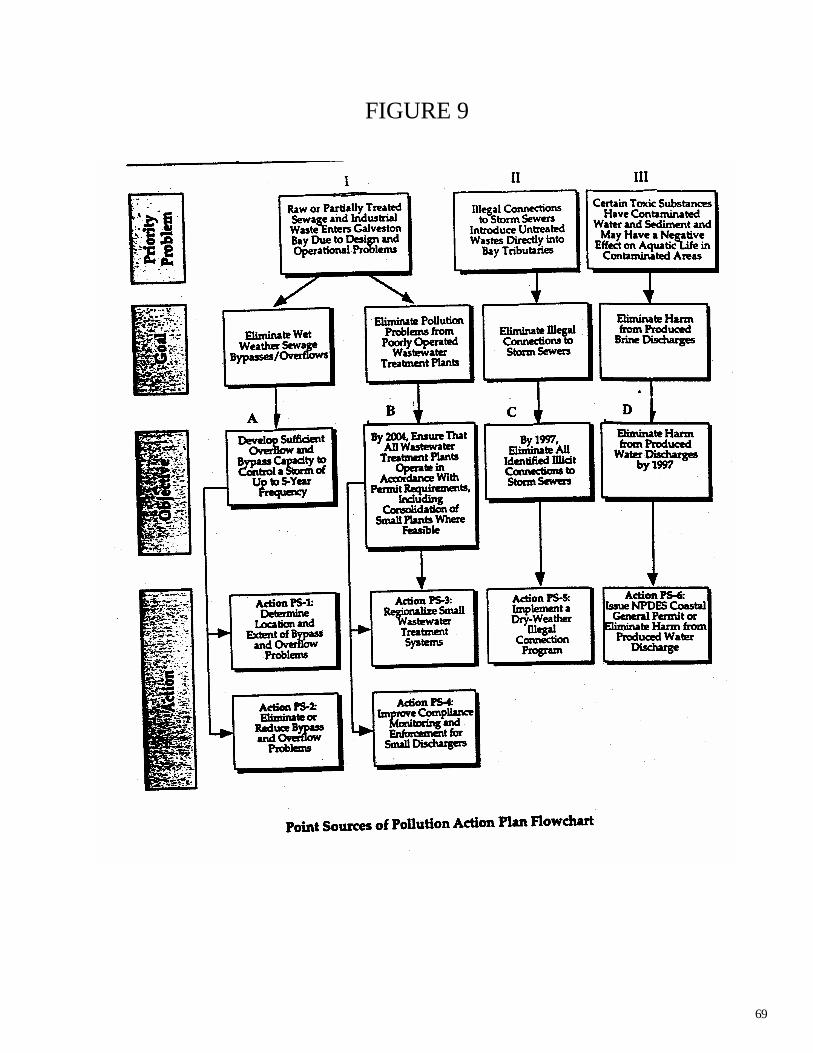
69
FIGURE 9

70
Public Participation and Education 5-Year Summary
To establish effective, ongoing public involvement with Galveston Bay resource management efforts at all levels; to improve future stewardship through education of students and the adult public concerning the bay ecosystem; and to invoke the public commitment and political will necessary to achieve effective comprehensive management. Highlights Public participation and education provide the foundation to every National Estuary Program. In Galveston Bay, the Public Participation and Education (PPE) Action Plan is being implemented by a variety of partners under The Plan, including non-profit organizations, agencies, academia, business, and industry. An educated and motivated public can provide much of the needed expertise, time, effort, and leadership to protect and monitor the Bay. Therefore, GBEP has been committed to building and supporting partnerships, developing tools, sponsoring events and training, with the goal of leveraging resources through coordination with local and regional entities. PPE efforts within the GBEP, have been focused on the following: providing the Galveston Bay Grant Program; sustaining the Galveston Bay Information Center and Network (website); coordinating the State of the Bay Symposium; networking with other coastal programs; presenting local lessons learned at national meetings; developing the local government initiative; supporting community events like Bay Day, Marsh Mania, and Trash Bash; hosting workshops; exhibiting; and, contributing to the Texas Environmental Survey. GOAL 1. Facilitate Public involvement in Bay Policy and Management. Action PPE -1: Establish Citizen Involvement as an Integral Part of the Galveston Bay Program
What: Establish citizen involvement as an integral part of the Galveston Bay Program, including the addition of permanent staff on The Galveston Bay Estuary Program with public participation responsibilities. Develop public involvement guidelines for implementing The Galveston Bay Plan. Step 1. Status: this step is complete and is ongoing. The GBEP has a full time Public Participation Coordinator to direct the Public Participation and Education (PPE) effort. The Public Participation Coordinator staffs the Public Participation and Education Subcommittee of the GBC, which provides oversight for outreach activities for program. Step 2. Status: this step is complete and is ongoing. The Galveston Bay Council includes citizen representatives. Environmental/Citizen’s Groups are represented as follows: Galveston Bay Foundation, Coastal Conservation Association, Citizens-at-Large, League of Women Voters, Low-income Community Representatives, Minority Representatives, Other Conservation Organizations. The Private Sector is represented as follows: Greater Houston Partnership, Utilities, Galveston County Council of Chambers, Industry (Small Business), East Harris County Manufacturer’s Association, Marinas, Commercial Fisheries.

71
Step 3. Status: this step has been initiated and is in progress. The GBEP participates in a public attitude survey: the biennial Texas Environmental Survey, a scientific survey conducted by Dr. Steve Klineberg, Rice University. An over-sampling of residents in five counties around Galveston Bay reveals information about recreational use, environmental behaviors like recycling, opinions on seafood safety, sources of bay pollution, etc. Through an EPA 319 grant, the GCHD also paid for an even further sampling in Galveston County. The 1996 survey results were published by the GBEP in a final report. Step 4. Status: this step has been initiated and is in progress. A public involvement evaluation has not been held specifically to address the effectiveness of public information and education efforts. However, the Texas Environmental Survey described above, does reveal trends in the public understanding of environmental issues. Additionally, The GBEP Biennial Report is an evaluation of progress in The Plan implementation and activities of the GBEP. This document is supplied to the GBC for information and to EPA in order show progress and secure federal funds from the EPA. The 1999 report was well received by EPA and the next will be conducted in FY 2001. A survey of implementation is done through a contract with the Galveston Bay Information Center (TAMU-G) to assess the involvement of Plan Partners in implementation. One component of this information gathering process is to identify education and outreach efforts associated with activities under The Plan. Action PPE-2: Continue and Expand the State of the Bay Symposia What: Continue and Expand the State of the Bay Symposia. Step 1. Status: this step is complete and is ongoing. The State of the Bay Symposia have been held biennially since 1992The Fifth Biennial State of the Bay Symposium will be held January 31 to February 2, 2001 at Moody Gardens Hotel and Convention Center, One Hope Blvd., Galveston, Texas. GBEP staff and a meeting planner from the TNRCC headquarters, coordinate with the Research Coordination Board to provide planning guidance and the teamwork necessary to accomplish the event. The Symposium will include a public session on Thursday evening. More specifics can be found at http://gbep.tamug.tamu.edu. Step 2. Status: this step is complete and is ongoing. The Galveston Bay Estuary Program publishes a proceedings for each Symposia, and makes it available to the legislature, the public scientists, and governmental agencies. GOAL 2. Increase education and outreach regarding issues affecting the estuary. Action PPE-3: Develop and Implement a Long-Range Adult Education and Outreach Program What: Support the development and implementation of a long-range adult education and outreach strategy, focusing on effective utilization of the media. Step 1. Status: this step has been initiated and is in progress. Building upon existing educational materials the GBEP supports a variety of efforts to educate people about the estuary. Partnerships between agencies, nonprofit organizations, school groups, industry, and agencies have produced some of the most successful outreach efforts. Some of the more popular topics include: the

72
estuarine ecosystem, wildlife, wetlands conservation, water conservation, understanding human uses, and pollution prevention. Examples of specific activities that implement goals in The Plan to educate adults have included community wide activities that both involve and educate, such as Bay Day, Trash Bash, and Household Hazardous Waste Collection activities. Electronic distribution of information has been facilitated through the Galveston Bay Information Network with Plan implementation information, a calendar, a searchable Bay Bibliography, useful links, grants information, etc. at http://gbep.tamug.tamu.edu. Videos, PSAs, brochures and radio ads (including Spanish-speaking audiences) have also been produced. Implemented in 2000, the Galveston Bay Grant Program supported the following projects for implementation of this action plan by the community: Spread the Word About Galveston Bay in Baytown; Bay Concepts Interactive Programs; Environmental Service Center (Outreach for Household Hazardous Waste Collection Facility in the City of Houston). Step 2. Status: this step has not been initiated and is not scheduled. Resources are not available to hire a Public Information Officer. Contact with the media has been focused on notification about specific events (like Symposium) and responding to specific bay related questions. Action PPE-4: Develop Specific Curricula for Use in Galveston Bay Watershed School Districts What: Support the development of specific curricula for use in Galveston Bay watershed school districts. Step 1. Status: this step has been initiated and is in progress. The Galveston Bay Ambassador program (GBF) continues to provide training and materials for volunteers to present priority issues for the Bay to students and K-12 teachers in the classroom. Step 2. Status: this step has been initiated and is in progress. Grant opportunities for environmental education are being supported. GBEP funds support the WET in the City, Galveston Bay Connections teacher training program for urban teachers. Initiated in 2000, Galveston Bay Grant Program supported Wetlands Environmental Camps in League City, Ball High School Intertidal Marsh Monitoring Project in Galveston and Pearland Eco-Education and Preservation project. GBEP has coordinated applications and written letters of support for grants to support education (example, The San Jacinto Marsh Restoration Project, Interpretation and Public Program Phase to TPW). Step 3. Status: this step has been initiated and is in progress. The GBEP is working with the TNRCC, the GBF, and area school districts to market bay-oriented lessons to area teachers. These include: Wet in the City, Galveston Bay Connections (EIH - UHCL); Save Our Streams Project -- video and companion literature (GBEP); Galveston Bay Fact Sheet Series; (GBF and USFWS); Science of Galveston Bay series of learning modules for teachers, (GBF); Children's Art Calendar, (GBF and Exxon); Sheldon Lake Environmental Education Center's Composting Education Classroom (GCWDA and SLEEC); Water Wise and Energy Efficient (Harris County Subsidence District); School Yard Habitats (USFWS and TPW); Walking Through the Wetlands - 30'x30' wetland exhibit - using tactile learning to increase knowledge and awareness of the wetland environment (Reliant Energy); State of the Bay Symposium Student Involvement. Support the TNRCC’s Teaching Environmental Sciences course. GOAL 3. Increase volunteer involvement in the ongoing stewardship of the estuary.
73
Action PPE-5: Continue to Develop Effective Volunteer Opportunities for Citizens What: Continue to support the development of effective, attractive, and organized volunteer opportunities for citizens. Currently available volunteer opportunities include citizen monitoring, discharge permit review, cord grass replanting, volunteer teacher programs, debris pickup, storm drain painting, and the Bay Day Festival. To further involve the public, additional opportunities will be identified, funded, and implemented. Step 1. Status: this step has been initiated and is in progress. The GBEP, GBF, H-GAC and TNRCC Regional staff have worked to ensure the effective continuation of the ongoing citizen monitoring program. Involving Citizen Water Quality Monitoring in Watershed Management Strategies is the most recent effort to involve citizen monitors in efforts that more directly address priorities within certain watersheds. Step 2. Status: this step has been initiated and is in progress. Bay Day is a unique event where participants gain an appreciation for the diverse uses of Galveston Bay and understand how those uses affect this unique body of water. Through understanding, the citizen participants often want to volunteer to help the Bay. Volunteers are recruited throughout the year for events like: Marsh Mania: one-day weekend restoration project designed to recruit local community citizens to restore marsh within their watershed, (GBF); Galveston Bay Yards and Neighbors Program: Bay-friendly landscape demonstration sites (Marine Extension Service); Waterfest: "water awareness month"at the Houston city zoo (City of Houston, Water Conservation). River, Lakes, Bays and Bayous Trash Bash (GCWDA); Natural Resource Center and Environmental Partners: nursery for cord grass for restoration activities throughout the bay (Reliant Energy). Step 3. Status: this step has been initiated and is in progress. GBEP monitors Galveston Bay Plan implementation efforts and recommends to the GBC opportunities for citizen volunteer implementation. GOAL 4. Increase the ability of citizens to effectively report pollution events. Action PPE-6: Maintain a citizen pollution reporting system. What. Maintain a Citizen Pollution Reporting System for the Bay region for all environmental media and secure long-term increased funding and staffing for the current pollution reporting system program. Currently, 21 various federal, state, and local- level agencies share responsibility for responding to environmental complaints reported by citizens in the five-county area surrounding the Bay. The relative responsibility of each of these agencies is not always clear. The current one-call system reduces confusion involved in reporting pollution events, and should be continued. Step 1. Status: this step was initiated but is no longer in progress. TNRCC no longer provides staff support or funding for the Citizen’s Pollution and Reporting Response System in the Houston Regional office. The PPE Subcommittee continues to maintain that the Pollution Reporting and Response System is a high priority. GBEP has identified several important issues that mus t be addressed for implementation of a successful Hotline. These include adequate funding, staffing, and appropriate housing. The GLO currently funds an Environmental Hotline for reporting spills (1-

74
800-832-8224). This line also takes calls for other types of pollution, however, there is no advertising for calls other than spills. GBEP has begun investigating the possibility of building on this existing Hotline or having another line specific to our area. Step 2. Status: this step was initiated but is no longer in progress. The GBEP will develop an expanded marketing campaign for a Hotline when appropriate. Marketing the existing Hotline (Step 1) would not be possible without more funding for the contractor to answer more calls that would result from more advertising. Currently, many groups including the GBF, the GBIC, the GCHD, the HCPC, and the GBEP report that they continue to field many inquiries from the general public, fielding them to the appropriate response agency. Step 3. Status: this step has not been initiated and is not scheduled. Development of an Incident Report Form, a data base and memorandum of understanding among the various response agencies would follow instituting a new hotline. GOAL 5. Expand and sustain local government involvement and support. Action PPE-7: Develop and Implement a Strategy for Informing, Educating, and Providing Support for Local Government Involvement What: Develop and implement a strategy for informing, educating, and providing support for local government involvement. Local governments frequently have difficulty keeping abreast of new environmental regulations and existing programs through which local environmental projects might potentially receive funding. Develop and implement a strategy for informing, educating, and providing support for local governments. Establish a program which acts as a clearinghouse of information. Step 1. Status: this step has been initiated and is in progress. GBEP coordinates with H-GAC to provide information for local governments which has included development of the Local Government Initiative (on GBIN website). Specific projects funded by the GBEP have included: City of League City for wetland camps for kids; City of Seabrook for development of a Wetland Conservation Plan; City of Baytown for outreach activities at city parks; City of Webster for habitat preservation planning and City of Pearland, developing model storm water management program GOAL 6. Assure effective communication with and outreach to specific bay user groups. Action PPE-8: Provide Assistance for User Groups Affected by Implementation of The Galveston Bay Plan What: Provide assistance for user groups affected by implementation of The Galveston Bay Plan. Emphasize an understanding of the link between user economic activity and the need for effective management by directly involving the publics that use the Bay.
75
Step 1. Status: this step has been initiated and is in progress. Although handbooks will not be updated, the Gulf of Mexico Repair Kit has updated homeowner information. The Galveston Bay Loop map and guide is currently under development, and will provide Bay users with information about Galveston Bay. Step 2. Status: this step has not been initiated and is not scheduled. Print pieces are distributed according to a “distribution plan.” No such plan has been developed for the handbooks as there is no plan to reprint at this time. Step 3. Status: this step has been initiated and is in progress. Workshops co-sponsored by GBEP have included: NPDES Phase II; Pollution prevention for small business, auto body facilities; voluntary inspection and information assistance program to reduce bacterial pollution caused by malfunctioning septic systems; supporting the networking and common goal of Bay enhancement through Bay Day festival which involves many partners. Galveston Bay Boater Pump-out Education Program. The Boater Waste Discussion Group has met regularly to develop strong education, enforcement and information exchange programs.

76
Research Action Plan 5-Year Summary
To support and focus Galveston Bay research to improve our knowledge of the bay and its relation to human uses, including: 1) stimulation of creativity and excellence in research; 2) encouragement of research related to decision-making activities under The Galveston Bay Plan by regulatory and management agencies; 3) support of timely implementation of the goals and objectives of The Galveston Bay Plan for the Galveston Bay system; and 4) dissemination of findings to regulatory and scientific communities and the public.
Highlights
An important strategy in the Galveston Bay Plan is to focus current research programs and increase research funding that will help managers of the bay solve critical environmental problems. To manage the bay as an entire ecosystem, common research goals are needed to : • Develop basic information on ecosystem structure, function, and productivity • focus scientific attention on management concerns of the bay • Establish research priorities • Coordinate and target funding • Assure that research results are available to agencies and individuals who can utilize the
findings and to the public at large Numerous research needs are identified in the Galveston Bay Plan as summarized in Appendix E. Without a coordinated program to review, rank, and carry out this research in an ecosystem context, the information base available to bay managers will not match the actions to address the bay’s problems. Research is therefore an important part of the Galveston Bay Plan. GOAL. To ensure that the basic and applied research that is required for Galveston Bay management decisions is available to managers.. Action RSC-1: Establish a Research Coordination Board. Step 1. Status: This step has been completed, but is ongoing. Galveston Bay staff continue to work with the Galveston Bay Council, management agencies, potential funding sources, and research institutions to determine appropriate representation for the RCB. Step 2. Status: This step has been completed, but is ongoing. The initial RCB was convened in 1995. The RCB currently continues planning and implementation of the Fifth Biennial State of the Bay Symposium and will update Galveston Bay Research needs. The RCB meets monthly during periods of high activity. Action RSC-2: Identify research needs from an ecosystem perspective.

Step 1. Status: This step has been initiated and is in progress. Galveston Bay research needs are listed in Appendix E of the Galveston Bay Plan. The RCB has developed a supplemental needs list that will be incorporated into the Appendix E list (see attached). These will be compared to the Proceedings of the Fifth Biennial State of the Bay Symposium and plan review findings to identify gaps in basic and applied research. The RCB and GBEP staff will design a ranking method to be clearly prioritized and the priority list will be updated after the symposium. Step 2. Status: This step has not been initiated, but is scheduled for the next five year period. The RCB will match prioritized needs with existing and potential funding sources. From this analysis, a funding plan will be prepared (RSC-4). Step 3. Status: This step has not been initiated, but is scheduled for the next five year period. The RCB will develop a research dissemination strategy, including publication of Galveston Bay research in scientific and technical journals, maintenance of a research clearinghouse within GBEP, and preparation and distribution of research findings to bay users, managers, and the public. Action RSC-3: Continue the State of the Bay process.
Step 1. Status: This step has been completed, but is ongoing. Four State of the Bay symposia have been completed, and planning continues for the fifth event. Findings will be utilized by the RCB to maintain current research priorities. Findings will also be summarized in electronic and/or printed Proceedings. Action RSC-4: Increase funding for Galveston Bay research.
Step 1. Status: This step has been initiated and is in progress. GBEP has ident ified some short-term windows of opportunity such as grants, but much additional work, using the research needs list (RSC-2) needs to be completed. Step 2. Status: This step has not been initiated, but is scheduled for the next five year period. The RCB will track funding opportunities and match them with research needs, as updated at the State of the Bay.

Step 3. Status: This step has not been initiated, but is scheduled for the next five year period. The RCB will link the prioritized list of research needs (RSC-2) with funding sources. These needs will be incorporated into the Galveston Bay Plan. Funding gaps will be identified and included as federal and state legislative priorities for GBEP. Step 4. Status: This step has not been initiated, but is scheduled for the next five year period. The RCB will develop a strategy to expand foundation and private sector funding sources for Galveston Bay research.

Appendix A: Regional Monitoring Plan Monitoring Subcommittee Update
The Monitoring Subcommittee continues to work with Dr. Oscar Criner of Texas Southern University, the principal investigator for the Status and Trends Project. The subcommittee is acting to facilitate completion of the project by funneling data sources and providing feedback to Dr. Criner. The Status and Trends Project will feed data and information to the bay barometer project, tentatively titled “The Health of the Bay”, and the 2nd Edition of The State of the Bay report. Due to the degree of complexity and connectivity of these projects, the subcommittee is also working with Dr. Jim Lester of the Environmental Institute of Houston, the principal investigator for the the 2nd Edition of The State of the Bay report to ensure that the work is completed in the proper sequence. Through these projects, the Monitoring Subcommittee has identified several issues in data compilation. The Status and Trends project has highlighted the need for regular monitoring of some habitat and living resource parameters. There appears to be a lack of recent habitat data. Species data is available, but there is no institutionalized mechanism for the transfer of these data to GBEP.
The Monitoring Subcommittee intends to spend considerable effort at the conclusion of the project and Symposium to find ways to make the data more readily available.

APPENDIX B:
PLAN PARTNERS IN IMPLEMENTATION U.S Coast Guard Galveston County Health District
Coastal Conservation Association TNRCC
TSU - School of Technology City of Houston
University of Texas @ Austin Rice University
Reliant Energy Galveston Bay Foundation
Port of Houston Authority Scenic Galveston
Galveston Bay Information Center Harris County Pollution Control
Seabrook Marine Laboratory Railroad Commission of Texas
Houston-Galveston Area Council Hillman Seafood
Galveston County NOAA - National Marine Fisheries
U.S. Geological Survey TAMU/ Sea Grant Program
Texas Water Development Board TSU - Environmental Science Inst.
Trinity River Authority Greater Houston Partnership
Audubon Society U.S. Environmental Protection Agency
U.S. Fish and Wildlife Service UHCL/Env. Inst. of Houston
Harris County Pollution Control Friends of Herman Park
Texas General Land Office Eddie V. Gray Wetlands Education
Lakewood Yacht Club Texas Parks & Wildlife Dept.
Bayou Preservation Association Texas Marine Advisory Service
City of Baytown Houston Independent School District
Maritime Sanitation U.S. Army Corps of Engineers
Chambers - Liberty Counties Navigation Dist. Texas State Soils & Water Conservation Board

Environmental Institute of Houston P.I.S.C.E.S
San Jacinto River Authority Texas Chemical Council
Harris County Flood Control District University of Texas - School of Public Health
Harris Galveston Subsidence District USDA Natural Resource Conservation Service
City of Texas City Harris County Pollution Control
City of Pasadena East Harris County Manufacturers Association
Texas Department of Transportation Texas Environmental Coalition
Harris County Flood Control Texas Department of Health
Gulf Coast Waste Disposal Authority City of Seabrook
City of Webster City of League City
City of La Porte Sims Bayou Nature Center
City of Galveston City of Pearland
Regional Boat Marinas NASA
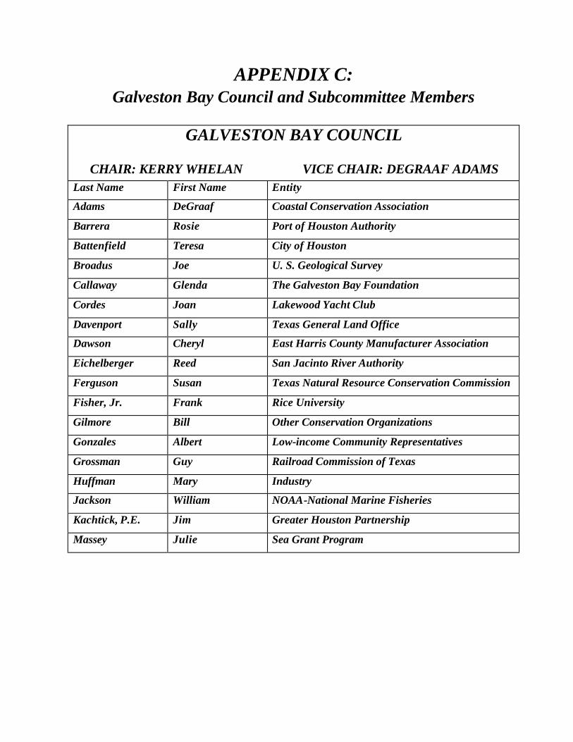
APPENDIX C:
Galveston Bay Council and Subcommittee Members
GALVESTON BAY COUNCIL
CHAIR: KERRY WHELAN VICE CHAIR: DEGRAAF ADAMS
Last Name First Name Entity
Adams DeGraaf Coastal Conservation Association
Barrera Rosie Port of Houston Authority
Battenfield Teresa City of Houston
Broadus Joe U. S. Geological Survey
Callaway Glenda The Galveston Bay Foundation
Cordes Joan Lakewood Yacht Club
Davenport Sally Texas General Land Office
Dawson Cheryl East Harris County Manufacturer Association
Eichelberger Reed San Jacinto River Authority
Ferguson Susan Texas Natural Resource Conservation Commission
Fisher, Jr. Frank Rice University
Gilmore Bill Other Conservation Organizations
Gonzales Albert Low-income Community Representatives
Grossman Guy Railroad Commission of Texas
Huffman Mary Industry
Jackson William NOAA-National Marine Fisheries
Kachtick, P.E. Jim Greater Houston Partnership
Massey Julie Sea Grant Program

Wynn-Lewis Dorethea Minority Representatives
Carl Masterson Houston-Galveston Area Council
Medina Rick U. S. Army Corps of Engineers
Moore James Texas Soil & Water Conservation Board
Nelson Doris Commercial Fisheries
Palmer Cathy Galveston county Council of Chambers
Powell Gary Texas Water Development Board
Remaley Tom Texas Department of Transportation
Roach Will U. S. Fish and Wildlife Service
Roussell Lori Gulf Coast Waste Disposal Authority
Seidensticker Edward Natural Resource Conservation Service
Smith Elsie Medium Local Governments
Stewart Sharron Citizens-at-Large
Talbott Mike Large Local Governments
Weber Becky Environmental Protection Agency
Whelan Kerry Utilities
Wiles Kirk Texas Department of Health
Willcox George “Pudge” Small Local Governments
Woodrow Jarrett “Woody” Texas Parks & Wildlife Department

NATURAL RESOURCE USES
GBEP STAFF: JEFF DALLA ROSA
CHAIR: BILL JACKSON VICE CHAIR: WILL ROACH
ADAMS DEGRAAF COASTAL CONSERVATION ASSOCIATION
CALLAWAY GLENDA GALVESTON BAY FOUNDATION
CALNAN TOM TEXAS GENERAL LAND OFFICE
DAVENPORT SALLY TEXAS GENERAL LAND OFFICE
DURHAM CHRISTY HOUSTON-GALVESTON AREA COUNCIL
EICHELBERGER REED SAN JACINTO RIVER AUTHORITY
GOLDBERG ALISHA GALVESTON BAY FOUNDATION
HUFFMAN JOHN U.S. FISH & WILDLIFE SERVICE
JACKSON WILLIAM NOAA-NAT'L MARINE FISHERIES
JACOBSON DOUG U.S. EPA
MCKINNEY, Ph.D. LARRY D. TEXAS PARKS & WILDLIFE
POWELL BILLY US COAST GUARD
POWELL GARY TEXAS WATER DEVELOPMENT BOARD
RAAB DAN DUPONT LAPORTE
ROACH WILL U.S. FISH & WILDLIFE SERVICE
ROUSSEL LORI GULF COAST WASTE DISPOSAL
SACRA BRECK RELIANT ENERGY
SEIDENSTICKER EDDIE NATURAL RESOURCE CONSERVATION SERVICE
WILES KIRK TEXAS DEPT. OF HEALTH
WOODROW WOODY TEXAS PARKS & WILDLIFE

WATER & SEDIMENT QUALITY
GBEP STAFF: SCOTT JONES/STEVE JOHNSTON
CHAIR: CARL MASTERSON VICE CHAIR: LEONARD LEVINE
MASTERSON CARL HOUSTON GALVESTON AREA COUNCIL
SHECK-FAHRER DEBRA U.S. GEOLOGICAL SURVEY
ADAMS DEGRAAF COASTAL CONSERVATION ASSOCIATION
PHILLIPS DONNA TNRCC REGION 12
JACOBSON DOUG U.S. EPA REGION 6
GROSSMAN GUY RAILROAD COMMISSION OF TX
NESBIT HEATHER GALVESTON BAY FOUNDATION
WRIGHT JEAN GALVESTON COUNTY HEALTH DISTRICT
KACHTICK JIM GREATER HOUSTON PARTNERSHIP
SNECK-FAHRER DEBRA U.S. GEOLOGICAL SURVEY
JACOB JOHN TEXAS SEA GRANT AND TAES
WARD JOHN TNRCC REGION 12
MASSEY JULIE TEXAS MARINE ADVISORY SERVICE
WILES KIRK TEXAS DEPT. OF HEALTH
LEVINE LEONARD GULF COAST WASTE DISPOSAL AUTH
TALBOTT MIKE FLOOD CONTROL DISTRICT
CROCKER PHIL U.S. EPA REGION 6

PUBLIC PARTICIPATION & EDUCATION
GBEP STAFF: MARIE NELSON
CHAIR: CATHY PALMER VICE CHAIR: TERRY TONKS
SACRA BRECK RELIANT ENERGY
WEISER BRENDA ENVIRONMENTAL INST. OF HOUSTON/UHCL
PALMER CATHY L.P. TEXAS A & M AT GALVESTON
BUDDENHAGEN CHUCK COLLEGE OF THE MAINLAND
GRAY CLARENCE TNRCC REGION 12
REYNOLDS DON HILLMANS SEAFOOD
WRIGHT JEAN GALVESTON COUNTY HEALTH DISTRICT
CORDES JOAN LAKEWOOD YACHT CLUB
HUFFMAN JOHN U.S. FISH & WILDLIFE SERVICE
MASSEY JULIE TEXAS MARINE ADVISORY SERVICE
MOORE LAURIE TEXAS GENERAL LAND OFFICE
ROUSSEL LORI GULF COAST WASTE DISPOSAL
SIPOCZ MARISSA TAEX SERVICE/ SEAGRANT
WHITWORTH MARY ELLEN BAYOU PRESERVATION ASSOCIATION
HUFFMAN MARY LEE INDUSTRY
MOORE RICHARD P.I.S.C.E.S.
RAY SAMMY TAMUG-GALVESTON
STEWART SHARRON TEXAS ENVIRONMENTAL COALITION
TUNKS TERRY GALVESTON BAY FOUNDATION
BRETTSCHNEIDER KAREN HOUSTON-GALVESTON AREA COUNCIL
LOVELACE TRAVIS EDDIE V. GRAY WETLANDS EDUCATION

MONITORING
GBEP STAFF: SCOTT JONES
CHAIR: ROBERT FIEDERLEIN VICE CHAIR: CATHY PALMER
CAIN BRIAN U.S. FISH AND WILDLIFE SERVICE
ELLIOTT CATHERINE HARRIS COUNTY FLOOD CONTROL DIST.
PALMER CATHY L.P. TEXAS A & M - GALVESTON
WEMPLE CHUCK HOUSTON GALVESTON AREA COUNCIL
BROCK DAVID TEXAS WATER DEVELOPMENT BOARD
PARMER DAVID TNRCC -AUSTIN
CRINER DR. OSCAR TEXAS SOUTHERN UNIVERSITY
MATTHEWS GEOFFREY NMFS
WRIGHT JEAN GALVESTON COUNTY HEALTH DISTRICT
BROADUS JOE U.S. GEOLOGICAL SURVEY
WILES KIRK TEXAS DEPT. OF HEALTH
SCHLICHT KURTIS TEXAS PARKS & WILDLIFE
ROBINSON LANCE TEXAS PARKS AND WILDLIFE
WHITWORTH MARY ELLEN BAYOU PRESERVATION ASSOCIATION
HOEPKER MELANIE HARRIS COUNTY POLLUTION CONTROL
JOHNICAN MICHAEL TEXAS SOUTHERN UNIVERSITY
HORTON PATRICK HOUSTON -GALVESTON AREA COUNCIL
GLASS PHIL U.S. FISH & WILDLIFE SERVICE
EICHELBERGER REED SAN JACINTO RIVER AUTHORITY
BROWNING RICHARD TRINITY RIVER AUTHORITY OF TEXAS
FIEDERLEIN ROBERT CITY OF HOUSTON
SLING RUSSELL RELIANT ENERGY
SMITH STEVE TNRCC

RESEARCH
GBEP STAFF: SCOTT JONES
CHAIR: RON MOOREHEAD VICE CHAIR: JIM LESTER
BAKER BILL RELIANT ENERGY
CAIN BRIAN U.S. FISH AND WILDLIFE SERVICE
PALMER CATHY L.P. TEXAS A & M AT GALVESTON
RAAB DAN DUPONT LAPORTE
BROCK DAVID TEXAS WATER DEVELOPMENT BOARD
MOORE DON RESEARCHER
LIPKA, PH.D. DOUGLAS A. EPA - REGION 6
SCHROEDER GENE UT HOUSTON PUBLIC HEALTH
EAST JEFF U.S. GEOLOGICAL SURVEY
LESTER JIM UNIV. OF HOUSTON-CLEAR LAKE
WILES KIRK TEXAS DEPT. OF HEALTH
ROUSSEL LORI GULF COAST WASTE DISPOSAL
CANTU MICHAEL HARRIS COUNTY POLLUTION CONTROL
ARMSTRONG NEAL UNIV. OF TEXAS AT AUSTIN
STICKNEY ROBERT SEA GRANT
ZIMMERMAN ROGER NATIONAL MARINE FISHERIES SERVICE
MOREHEAD RON TEXAS CHEMICAL COUNCIL
MARSHALLECK STEPHANIE TEXAS PARKS & WILDLIFE DEPT.