GAIY SUEYS O O II AY A AACE AEAS, ICOIA 8 · 2015-12-02 · COMMOWEA O AUSAIA EAME O AIOA EEOME...
14
COMMONWEALTH OF AUSTRALIA DEPARTMENT OF NATIONAL DEVELOPMENT BUREAU OF MINERAL RESOURCES, GEOLOGY AND GEOPHYSICS RECORD No. 1965/64 020443 GRAVITY SURVEYS OF PORT PHILLIP BAY AND ADJACENT AREAS, VICTORIA 1957-1958 by S. GUNSON and L.W. WILLIAMS The information contained in this report has been obtained by the Department of National Development as part of the policy of the Commonwealth Government to assist in the exploration and development of mineral resources. It may not be published in any form or used in a company prospectus or statement without the permission in writing of the Director, Bureau of Mineral Resources, Geology and Geophysics.
Transcript of GAIY SUEYS O O II AY A AACE AEAS, ICOIA 8 · 2015-12-02 · COMMOWEA O AUSAIA EAME O AIOA EEOME...

COMMONWEALTH OF AUSTRALIA
DEPARTMENT OF NATIONAL DEVELOPMENT
BUREAU OF MINERAL RESOURCES, GEOLOGY AND GEOPHYSICS
RECORD No. 1965/64
020443
GRAVITY SURVEYS OFPORT PHILLIP BAY
AND ADJACENT AREAS,VICTORIA 1957-1958
by
S. GUNSON and L.W. WILLIAMS
The information contained in this report has been obtained bythe Department of National Development as part of the policyof the Commonwealth Government to assist in the explorationand development of mineral resources. It may not be publishedin any form or used in a company prospectus or statement withoutthe permission in writing of the Director, Bureau of MineralResources, Geology and Geophysics.

COMMONWEALTH OF AUSTRALIA
DEPARTMENT OF NATIONAL DEVELOPMENT
BUREAU OF MINERAL RESOURCES, GEOLOGY AND GEOPHYSICS
RECORD No. 1965/64
GRAVITY SURVEYS OFPORT PHILLIP BAY
AND ADJACENT AREAS,VICTORIA 1957-1958
by
S. GUNSON and L.W. WILLIAMS
The information contained in this report has been obtained bythe Department of National Development as part of the policyof the Commonwealth Government to assist in the explorationand development of mineral resources. It may not be publishedin any form or used in a company prospectus or statement withoutthe permission in writing of the Director, Bureau of MineralResources, Geology and Geophysics.

CONTENTS
SUMMARY
Page
1. INTRODUCTION 1
2. GEOLOGY AND DESCRIPTION OF THE AREA 1
3. EQUIPMENT 2
4. DELAYS 4
5. FIELD 170RK AND REDUCTION OF RESULTS 5
6. INTERPRETATION 6
7. CONCLUSIONS 78. RECOMMENDATIONS 8
9. REFERENCES 9
ILLUSTRATIONS
Plate 1.^Geological structure of the Port Phillip Bayarea^(Drawing No.J55/B2-55)
Plate 2. Bouguer anomaly contour map^ (J55/B2-54)
SUMMARY
The Bureau of Mineral Resources made an underwatergravity survey of Port Phillip Bay in 1957 and a gravity surveyof Mornington Peninsula in 1958. The combined results of thesesurveys show that the area is structurally more complex than waspreviously supposed. The main feature to be outlined by theBougueranomaly contours is a down-thrust block in the south-western part of the Bay. It is bounded on the north, east, andwest by faults, but its southern limit was not determined.Further surveys are recommended to the south and west of PortPhillip Bay.
1965/64

\' ~
1 • INTRODUCTION
The gravity surveys described in this Record were mad~ by the Bureau of Mineral Resources as regional surveys. The field work was divided into two parts: an underwater gravity survey of Port Phillip Bay, and a gravity survey of 1.10rnington Peninsula. In addition to the results of these surveys, information gathered during previous surveys of adjoining areas has been used in the compilation of the gravity anomaly contour map.
The underwater survey commenced on 18th June 1957 and was completed on 16th December 1957. A remote-controlled gravity meter, model ~N-2R, manufactured by North American Geophysical Co. was used from a boat (auxiliar,y ketch 'Commissioner'), which was chartered for the duration of the survey. The crew of the boat consisted of one or two geophysicists and a field assistant to operate the gravity meter equipment, and a master, engineer, and one seaman to handle the boat.
The survey of the Mornington Peninsula was made between 19th February and 17th 1~ch 1958-by one geophysicist, who used a Worden gravity meter and a vehicle-mounted elevation meter, model 204, manufactured by Western Geophysical Co~
This Record supersedes the ~reliminar.y report on the survey by Gunson, Williams, and Dooley t1959).
2. GEOLOGY AND DESCRIPTION OF THE AREA
Mornington Peninsula
Ph.ysiography. Mornington Peninsula is the name given to the projection of land that separates Port Phillip Bay and Western Port Bay. It is roughly rectangular and is about thirty miles long and ten miles wide. From its most westerly part, a point of land, which is covered mainly by low sand dunes, extends to the north-west to form Point Nepean. The Peninsula consists of low hills along itu length and some low land on the eastern side.
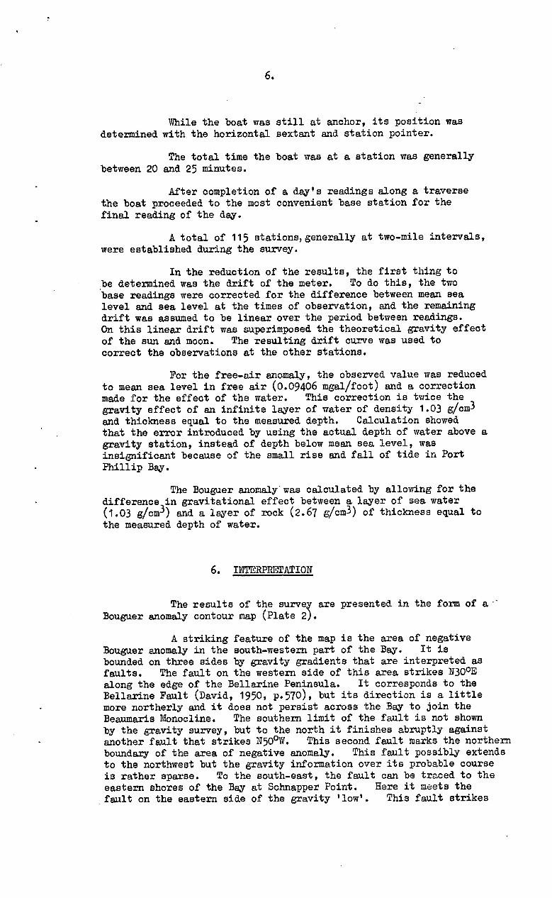
Geology. Hills (1946) describes the high land of the Peninsula as a horst bounded on the west by the Selwyn Fault and on the east by the Tyabb Fault. Plate 1 shows the geological structure of the area.
Port Phillip Bay
Ph.vsiograpny. Port Phillip Bay is an irregularly shaped, almost land-locked body of water. The foreshore is generally lowlying except for the Mornington Peninsula and the Bellarine Peninsula.
Port Phillip Heads, which stand on either side of the opening to the sea, comprise Point Nepean on the east and Point Lonsdale on the west. The entrance to the Bay is two miles wide and has a very irregular bottom, which gives rise to tidal rips and eddies.

2.
Most of the Bay has water depths in the range five tothirteen fathoms, but there are large banks of mud and sand with onlya few feet of water over them, in the southwestern part of the Bay.
The change of water level in response to tides is abouttwo feet at Williamstown and between four and five feet at PortPhillip Heads.
Geology. Plate 1 shows the geological structure of theareas surrounding Port Phillip Bay.
Hills (1946, p.160) describes the Bay as part of thePort Phillip Sunkland, which is bounded on the west by the LovelyBanks Monocline and the Rowsley Fault, and on the east by theSelwyn Fault, which is considered to be a 'shatter belt' of manysmall faults, rather than a single fault plane.
The majority of the area surrounding the Bay is coveredby Recent, Pleistocene, and Tertiary sediments, and large areas ofNewer and Older Basalts. Granite is known in the You Yangs, atArthurs Seat, and north-east from Dandenong. Outcrops of Silurianand Ordovician sediments occur on the Mornington Peninsula.
3. EQVIPMENT
The equipment used on the Mornington Peninsula surveywas a Worden gravity meter No. 260 and a Western elevation meterNo. 204.
Both these instruments are well known and will not bedescribed here. The remainder of this section will be devoted to adescription of the marine gravity meter and its associated equipment.
The gravity meter
This is a normal land meter that has been modified sothat the position of the beam and the tilt of the meter can be detectedelectrically, as well as optically. The external controls (clamp,reset, and reading dial) can be operated electrically through a motorpanel that is fitted on top of the meter and enclosed with it in awatertight bell. The bell is-mounted in gimbal rings that are attachedto a rigid circular base; its attitude is controlled by two electricmotors, which respond to signals that originate from the level detectorson the meter. All the control and power supply circuits enter thebell from a neoprene-covered cable through a watertight connector.The other end of this cable is attached to the control unit on theboat.
The control unit
This consists of four units, all mounted in one rack. Theunits and their functions are as follows:
The power supply. This unit distributes the electricpower for all the measuring and controlling circuits. It operatesfrom a 115-volt, 60-c/s supply when the meter is operating, but has a'standby' supply. for periods when the meter is temporarily not in use,e.g. overnight.^The 'standby' supply is a 12-volt battery andvibrator, which supply power only to the gravity meter heaters. Thereis provision for this supply to operate the clamp circuit in an emergency,for example, when failure of the 115-volt supply occurs while the meteris unclamped.

3.
The level amplifier units. These are a set of twoamplifiers which amplify the error signals received from the leveldetectors on the gravity meter and apply the output to the levellingmotors.
Gravity/depth amplifier. This is an amplifier whicheither amplifies the signals that show the position of the beam of thegravity meter, or. amplifies the signal from the depth-measuringdevice. It can perform only one of these functions at a time.The amplified signals are applied to indicators on the operatingconsole.
The operating console. This is the panel from which allthe operating of the meter is done. It has controls for all functionsof the meter and is equipped with indicators and meters to showwhether the gravity meter is level, clamped or unclamped, set on thenull point, and at its correct temperature. The cycling of theheating circuits can be checked by observing the changes of heatercurrent.
The console is equipped with a reading dial of the sametype as that on the gravity meter. The dial on the console controlsthat on the meter through a selsyn motor system.
The depth-measuring device has a null indicator and areading dial that is read in the same way as the gravity dial.
Power Generator
The power requirements for all this equipment, when usedon a boat, are supplied by a 1500-watt, 115-volt, 60-c/s supplygenerator that is driven by a petrol engine.
Hoist and power unit
The bell with the gravity meter sealed inside is loweredfrom the boat to the sea bottom on the end of a stranded steelwire cable, the other end of which is attached to a hydraulic winch.A two-cylinder petrol engine drives the hydraulic pump, which suppliesoil under pressure to the winch. The cable from the winch is ledthrough a shock-absorbing system, over a jib, and is then attachedto the bell. There is a mechanical arrangement to prevent the bellhitting the side of the boat during lowering and raising.
The boat
The boat used in this survey was the auxiliary ketch'Commissioner', chartered with a crew of three.^It was a single-screw vessel, having a length of 85 ft, a beam of 18 ft, a draught of81.- ft, and a maximum speed (for surveying duties) of eight knots. Ithad accommodation for six people. A boat of this size is notessential and in fact, on Port Phillip Bay, a boat drawing less waterwould have been desirable. The requirements of space for the gravityequipment are: a clean deck space of 10 ft x 4 ft for the hoistingwinch, a sheltered and well ventilated space for the generator andhydraulic pump, and a sheltered space (from which the winch can beseen) for the control unit.

4.
On the 'Commissioner', the winch was mounted over theforward hold, the generator and pump were fixed in the hold belowthe winch, and the control unit was installed in the wheelhouse.
Surveying equipment
The boat was equipped with two magnetic compasses,one in the wheelhouse for steering and the other on the after deckas a 'standard' compass. These compasses were used only to bringthe boat to an approximate position where a reading was required.The actual position of the reading was found and plotted using ahorizontal sextant and a station pointer. The horizontal sextantwas used to measure the two included angles subtended at the boatby three known landmarks. These angles were then set between thethree arms of the station pointer, the station pointer placed on achart so that the arms passed through the positions of the knownlandmarks, and the position of the boat plotted at the intersectionof the arms. The horizontal sextant had a micrometer dial thatcould be read to one minute of arc; the verniers on the stationpointer also read to one minute of arc.
4. DELAYS
A considerable amount of survey time was lost during thecourse of the underwater gravity survey for various reasons.
Instrument breakdowns
The only serious trouble with the equipment was thecontinual breaking of the mainspring suspension loops of the gravitymeter. Very little effective work was done during the first threemonths because of this trouble. The cause was eventually found tobe an auxiliary engine mounted on the deck. This engine set upvibrations of the same frequency as the natural frequency of themainspring system, and the loops failed apparently by fatigue. Thetrouble was overcome by shock-mounting the hoist and replacing theengine by one that ran at a different speed.
Unfavourable weather
Two types of unfavourable weather were encountered, bothof which caused delays.
Rough conditions. In rough conditions it was notadvisable to put the bell down because of risk of damage to thegravity meter. When the boat was rolling or pitching heavily, therewas the danger that the bell would hit the bottom with sufficientforce to damage the meter. There was also the danger that theanchor might drag while the bell was on the bottom and cause the bellalso to drag.
Bad visibility. On calm days when conditions wereotherwise perfect for operating, there was sometimes fog. Thisprevented the use of the sextant, and the location of the boat couldnot be determined. No work was possible until the fog disappeared.

5·
On this survey, about 2~ of the time for which the equipment was working satisfactorily was lost owing to unfavourable weather.
Installation and removal of equipment
Although it cannot be strictly regarded as a delay, it is of interest to note the time taken for the installation of the equipment on the boat, and its removal at the end of the survey. One week was required for the initial installation of the equipment, on the boat. Later, approximately six days were spent in installing different anchor winch gear. Three days were required to remove the equipment from the boat.
5. FIELD WORK .AND REDUCTION OF RESULTS
Mornington Peninsula
A network of 111 stetions was laid out along roads and railway lines, the stations being at approximately two-mile intervals.
The gravity values were carried from points of known value and are based on a value of 919,919.0 milligals at the National Gravity Base at Footscray.
Victorian Railway levels were available for the gravity stations that were located at railway stations; these levels were also used as controls for the elevation meter survey along roads. The levels were adjusted to make them relative to mean see level.
Standard methods were used to calculate free-air and Bouguer anomalies for each station. A density of 2.61 gjcm3 was used in the reduction.
Port Phillip Bay
It was found that a sufficiently good check could be kept on the drift of the underwe.ter gravity meter by measuring at a base station only at the beginning and end of a day's work. As it was desirable to moor the boat to a jetty at night, and in order to save the necessity of travelling long distances back to one base station, base stations were established at six jetties situated conveniently round the Bay.
The first reading on any day was at a base station at a jetty. The boat then proceeded to the position of the next seastation and dropped anchor. After the boat had taken up a steady riding position under the influence of wind and tide, the bell was lowered to the bottom and sufficient slack cable was run out to ensure that the bell would not be eSfected by the motion of the boat. The operator at the console then turned on the level motors, waited until the instrument was level, then unclamped the gravity meter, and took a gravity reading. The meter was then clamped, a depth reading taken, and the bell brought back to the surface. Another depth reading was then taken to check zero drift and the bell was lifted again into its travelling position.
6.
While the boat was still at anchor, its position wasdetermined with the horizontal sextant and station pointer.
The total time the boat was at a station was generallybetween 20 and 25 minutes.
After completion of a day's readings along a traversethe boat proceeded to the most convenient base station for thefinal reading of the day.
A total of 115 stations,generally at two-mile intervals,were established during the survey.
In the reduction of the results, the first thing tobe determined was the drift of the meter. To do this, the twobase readings were corrected for the difference between mean sealevel and sea level at the times of observation, and the remainingdrift was assumed to be linear over the period between readings.On this linear drift was superimposed the theoretical gravity effectof the sun and moon. The resulting drift curve was used tocorrect the observations at the other stations.
For the free-air anomaly, the observed value was reducedto mean sea level in free air (0.09406 mgal/foot) and a correctionmade for the effect of the water. This correction is twice thegravity effect of an infinite layer of water of density 1.03 gicm3and thickness equal to the measured depth. Calculation showedthat the error introduced by using the actual depth of water above agravity station, instead of depth below mean sea level, wasinsignificant because of the small rise and fall of tide in PortPhillip Bay.
The Bouguer anomaly was calculated by allowing for thedifference in gravitational effect between a layer of sea water(1.03 gicm-3) and a layer of rock (2.67 g/cm 3) of thickness equal tothe measured depth of water.
6. INTERPRETATION
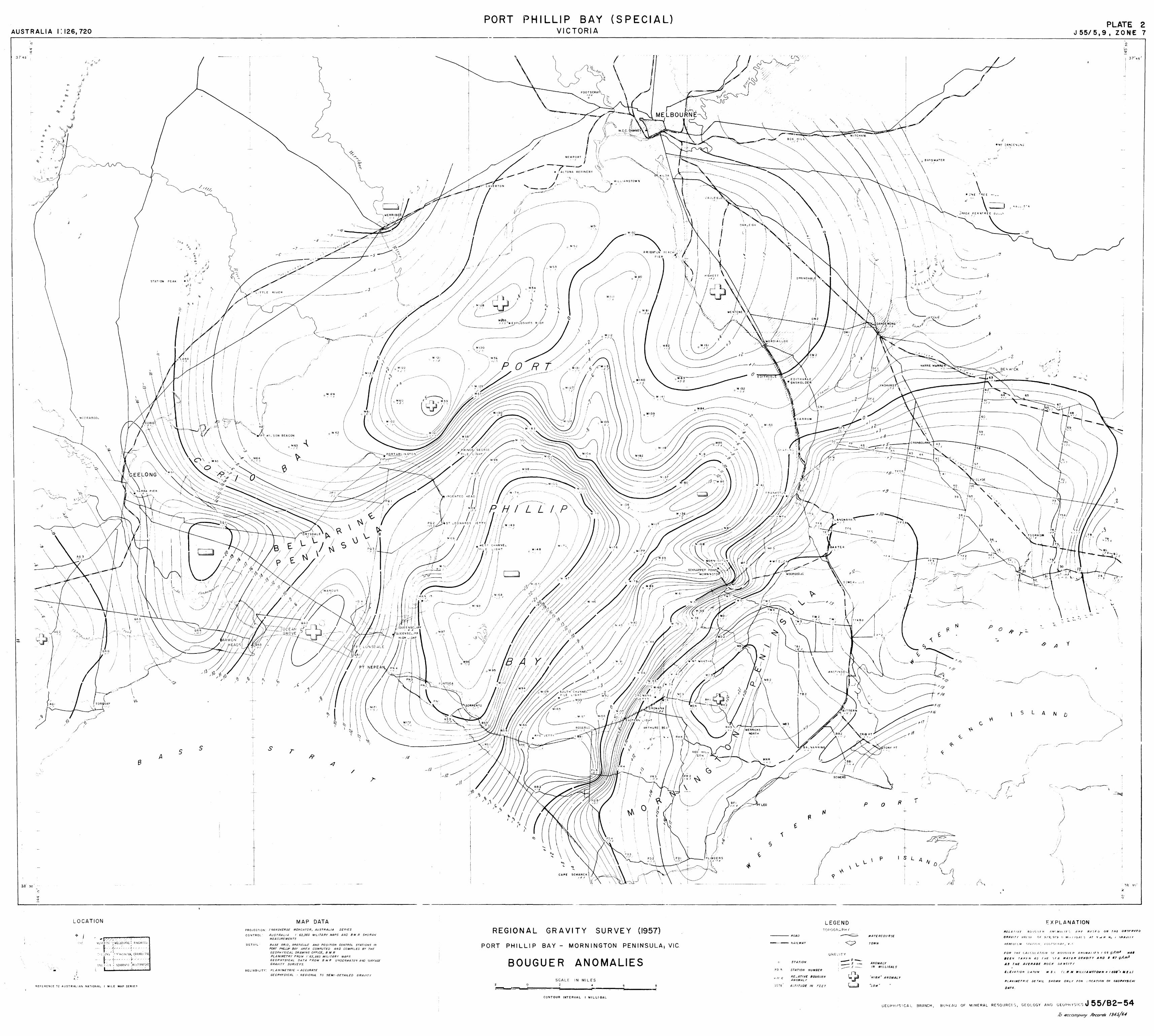
The results of the survey are presented in the form of a . 'Bouguer anomaly contour map (Plate 2).
A striking feature of the map is the area of negativeBouguer anomaly in the south-western part of the Bay. It isbounded on three sides by gravity gradients that are interpreted asfaults. The fault on the western side of this area strikes N30 0Ealong the edge of the Bellarine Peninsula. It corresponds to theBellarine Fault (David, 1950, p.570), but its direction is a littlemore northerly and it does not persist across the Bay to join theBeaumaris tionocline. The southern limit of the fault is not shownby the gravity survey, but to the north it finishes abruptly againstanother fault that strikes N50°W. This second fault marks the northernboundary of the area of negative anomaly. This fault possibly extendsto the northwest but the gravity information over its probable courseis rather sparse. To the south-east, the fault can be traced to theeastern shores of the Bey at Schnapper Point. Here it meets the
. fault on the eastern side of the gravity 'low'. This fault strikes

N30°E and is evidently the well-known Selwyn Fault (David, 1950,p.570). The gravity indications of the fault do not extend tothe north as far as the fault is usually mapped; its extension tothe south is uncertain, but additional gravity surveying in theCape Schank area would probably resolve it.
The three faults just described enclose three sides ofan area of negative gravity anomaly. This is evidently a down-faulted block. The gravity survey did not disclose the southernend of the block, which is outside Port Phillip Bay, but the
. anomaly seems as though it is becoming less negative seaward fromPoint Nepean.
The gravity map shows an area of positive gravityanomaly over the Mornington Peninsula. It is considered that these vvirhigh values arise from the presence of Older Basalt, which isexposed in places, notably in the south, but it may exist under aTertiary cover in other places. The Peninsula is bounded on thewest by the Selwyn Fault. Its eastern boundary is not definedprecisely by the gravity results, but there seems to be some effectfrom the Tyabb Fault.
A closed gravity 'high' occurs four miles north-east ofPortarlington on the western side of Port Phillip Bay at theentrance to Corio Bay. It is Considered to be due to the presenceof underlying basalt, which is probably the Older Basalt, but thiscannot be decided on the gravity evidence alone.
;CFurther west and on the southern side of Corio Bay^• S'
there is a gravity gradient suggestive of a fault that strikes^•A
N70°W for a distance of about seven miles; on the west, the gradientveers to the north and becomes less steep, and on the east, it merges V77 'into the gradient associated with the Bellarine Fault. This gradientdoes not correspond to any known geological fault and is indeed atvariance with the Barrabool and Curlewis Faults, which generallyfollow the southern shore of Corio Bay (Hills, 1946, p.161).^Afurther and.perhaps more striking.departure of the gravity evidencefrom the geological is that the former suggests a fault down-thrownon the south side while the latter would make the fault down-thrownto the north.
The only remaining features to be described are thetwo gravity trends, one in the north centre of Port Phillip Bay andthe other in the north east, which join in the centre of the Bay.These two seem to represent the old courses of the Yarra River and theDandenong Creek (Hills, 1946, p.220).^As mentioned earlier, theBeaumaris Monocline cannot, on the gravity evidence, be considered anextension of the Bellarine Fault, but is apparently the south-easternflank of a dome or nosing feature that plunges to the southwestbetween the old courses of the Yarra River and the Dandenong Creek.
7. CONCLUSIONS
The use of the underwater gravity meter was establishedas an exploration instrument.

8.
The results of the present survey point to the followingconclusions:
1. The Selwyn Fault, as detected by gravity, coincides withthe geological postulate except that the gravity results suggest aslight curtailment of its extension to the north.
2. The Bellarine Fault is shown to have a more northerlystrike and not to continue across the Bay to join the BeaumarisMonocline, as previously supposed.
3. A new fault has been detected in the centre of the Bay.This fault marks the northern end of a down-faulted block in thesouth of the Bay. The fault extends across the Bay from SchnapperPoint in the east and is well marked until it reaches the BellarineFault. The effect is then modified by other features but it almostcertainly extends past the north-western shores of the Bay.
4. A downthrust block has been outlined in the south-westernpart of the Bay. Its southern limit is not known but it isbounded on the east, west, and north by the faults described in1, 2, and 3.
5. The presence of a mass of basalt beneath the Bay, betweenthe Bellarine Peninsula and Werribee River, is indicated.
6. The Beaumaris Monocline exists as the south-eastern flankof an anticline that pitches south-west.
7. The presence on Mornington Peninsula of basalt under aTertiary sedimentary cover is indicated by the positive anomalieson the Peninsula.
8. The Tyabb Fault is only weakly indicated and it isbelieved therefore to have only a small throw.
9. The old courses of the Yarra River and Dandenong Creekover what is now Port Phillip Bay can be determined from the gravitymap.
10. The gravity anomalies in the western part of Corio Baydo not support the present geological postulates as regardsfaulting in the area.
8. RECOMENDATIONS
It is recommended that additional gravity surveying bedone in the following areas:
(a) Cape Schank.
(b) The hinterland of Port Phillip Bay between Melbourneand Geelong.
(c) South-west and east of Geelong.

DAVID, T.W.E.
GUNSON, S., WILLIAMS, L.W., and DOOLEY, J.C.
HILLS, E. S.
: ~.
1950
1959
1946
, <?I . ;",
r . '-." "' .. ~ ..
THE GEOLOGY OF THE COMMONWEALTH OF AUSTRALIA, Vol.1. London, Edward Arnold.
Preliminary report on gravity survey of Port Phillip Bay and adjacent areas. Bur. Min. Resour. Aust. Rec. 1959/34.
THE PHYSIOGP~PHY OF VICTORIA, 2nd Ed. Melbourne, Whitcombe & Tombs.
., .. '- ", "" "l'~" "~' .••• ~.~ •• '.'
'. 'I'" •

·0 PLATE I ·0 o ~ ~ ~ ~~----~----------------~----------------~------'-----~---------------------------'-37°30'
.£1//-:.
?",f rou rANGS
PORT PHILLIP
SUNKLAND /
" /
"
L-----------------------------------------------------------------------------------~38°45'
MILES
GEOLOGICAL STRUCTURE OF THE
PORT PHILLIP BAY AREA
SCALE 16 0 16 32 MILES Eb=-3~~==~E==3E:~==~~~~~~~~~~!============~1
Geology from Hills (1946,p.161) & Dovid (J950, p.570)
Geophysical Branch, Bureau of Mineral Resources, G~%gy and Geophysics J 55/ B2 - 55 .70 accompanJ Record N" /!J6 S / () 4
AUSTRALIA I: 126, 720
3745
~--
...---------''\ --: \ -., .
,
''-----:''''--,;: ~0_
,,} >
\,,~_J'·r ..
,
'\ \ "
\
,~~
\ \
'-
\ \
\ \
\
\.
\
\ \
'" -' - ~ -
(
\
/ /
TOR~UAY , ' ,
--;J /
/ /~
LOCATION
" I
, '
L I MILE: MAP SERIE-~ 'lEFERENC£ ~c AUSTRAL AN NATIONA
f3
STATION PlAIl
, ,
I i I
, I
'\1 -"
I
I ,
"
A 5 s
i
/ I
I ,
T !
,
I
+
I t
PROJECTION
CONTROL
DETAIL"
RELlAB'I..ITY·
s T
/
MAP DATA MERCATOR, AUSTRALIA SERIES
TRANSVERSE D 8111 R SHORAN / 63.360 MILI,ARY MAPH 4N AUSTRALIA •
M£AS:JREiIIENrs
AND PO"'ITION CONTROL STAT/ONS IN 84SE G!TID, 6!TATICULE PUT;O -411'0 COMPILED BY THE PORT PHILLIP B-4Y 4RE-4 COM
G£OPHYSfCAL DRAWI"IG OFF{~£~~I~:R'" fl/APS
PLAN/METRY FRO,V I 63,.315 B fI/ R U"D£RWATE'f AlVD 7URFACE 6EOPHYSICAL DA TA FRO II(
6RAVITY SURVEYS.
PLANIMETRIC - ACCU'fATE
GECPl1rSICAL ~ - DEGIO/VAL TO SEN/-DErAILED GRAVITY
i
--/4
,/3
PORT PHILLIP BAY VICTORIA
(SPECIAL)
REGIONAL
PORT PHILLIP
GRAVITY
/
\
, /
i /
• I' e _ f} "
I
tM, MELBOURNE
i
SURVEY (1957)
BAY - MORNINGTON PENINSULA; VIC,
BOUGUER ANOMALIES
, ?- I _
SCALE IN MILES
CONTOUR INTERVAL
• r-
I MILLtGAL
,
) /
---NOAD
---' i<AILWAY
STATION
p
N
I, I
TO~" ~T
o
Y- \ 1-\
I-p
LEGEND F»-'JG",:,PHr'
~
\.ikt,';ITY __ 0_. '_5 __
____ I ~_._
TOWN
ANOMALY IN MILL/GAl. S'
R
?- II (;
STAr/ON NI)M!I£R
RE ~ A iI VE 80/J(jU£'f ANOMIJLr
'HIG"· ANOMALY
A~rrri/Q£ IN FEt r
-''-.----
r
(jEOPHfSICAL BRANCH,
\.
c
",
""
«
p o
r / ' f,
! !. 'r' ."
s L A
/
: .
A y
PLATE 2 J 55/5,9, ZONE 7
-
'~
\
,,-----~ --.
N D
./ - j
\
)
/
FXPLAlliATION
"N 1111 OIl,rlll"'fJ N(Mfj'lf', ,"HI' 8/.,1(" .ELAfJllf fjU)f,'JfH A , ~ I t)/iAV'llr
AI'- AT ~ ,01 H '-''' r, 'J1''J.'1(~ '/ M!"f~ , (JRAVtr ( '{1l1'1t )
I'FNfUI(.fw/
PLANIIIIETR,-C
DATil
RESOURCf~, GEOLOGY AND BU>'-EAU OF MINERAL CE""Hf';!';S J 55/82- 54 to dccompanj' A't'corm-- 196.5/6--1