FY 2002 Planning Update for the Burns District · U P D A T E P L A N N I N G . U.S. Department of...
40
U.S. DEPARTMENT OF THE INTERIOR BUREAU OF LAND MANAGEMENT U.S. DEPARTMENT OF THE INTERIOR BUREAU OF LAND MANAGEMENT U.S. Department of the Interior Bureau of Land Management Burns District Office 28910 Hwy 20 West Hines, Oregon 97738 March 2002 FY 2002 Planning Update for the Burns District 1
Transcript of FY 2002 Planning Update for the Burns District · U P D A T E P L A N N I N G . U.S. Department of...

U.S. DEPARTMENT OF THE INTERIORBUREAU OF LAND MANAGEMENT
U.S. DEPARTMENT OF THE INTERIOR BUREAU OF LAND MANAGEMENT
U.S. Department of the InteriorBureau of Land Management
Burns District Office 28910 Hwy 20 West Hines, Oregon 97738 March 2002
FY 2002 Planning Update for the Burns District
1

2
As the Nation’s principal conservation agency, the Department of the Interior has responsibility for most of our Nationally-owned public land and natural resources. This includes fostering the wisest uses of our land and water resources, protecting our fish and wildlife, preserving the environmental and cultural values of our National parks and historical places, and providing for the enjoyment of life through outdoor recreation. The Department assesses our energy and mineral resources and works to assure that their development is in the best interest of all our people. The Department also has a major responsibility for American Indian reservation communities and for people who live in Island Territories under U. S. administration.
BLM/OR/WA/PT-02/020 + 1792
Big Indian Canyon - Steens Mountain Cover photo by Mark Armstrong

U P D A T E
P L A N N I N G U.S. Department of the Interior Bureau of Land Management
Burns District Office 28910 Hwy 20 West Hines, Oregon 97738 Web Site: http://www.or.blm.gov/Burns
U.S. DEPARTMENT OF THE INTERIORBUREAU OF LAND MANAGEMENT
U.S. DEPARTMENT OF THE INTERIOR BUREAU OF LAND MANAGEMENT
MARCH 2002
Introduction This is hte tenth annual Planning Update published by the Burns District. Due to extenuating circumstances we were unable to get the Fiscal Year (FY) 01 update completed in a timely fashion. Therefore, we have combined FY01 Planning Update with FY02. This issue reports highlights of FY00 and FY01 accomplishments and work planned for FY02.
It is our desire to keep you informed on issues, activities, and opportunities we think are of interest to our publics. More importantly, we are seeking ideas and comments from those who may be affected by our multiple-use management programs. For general information or for comments regarding the Planning Update, please write to the address shown above.
Please note the change of address. The County has changed all rural addresses to assist the 911 for easier, more rapid location. Please note this change for future correspondence.
What You Can Find In This Document . . .
Updates like this one are published annually. While the format is flexible, major sections similar to those described below will be included in each edition.
Summary of Work: This section identifies the fiscal year accomplishments and work proposed for the following year. Usually, only significant work or issues will be discussed. More general information is available to individuals upon request. Page 5
Rangeland Program Summary: This section outlines progress being made in implementing the rangeland management objectives identified in the Resource Areas’ (RAs’) land use plans. Page 15
Environmental Assessment (EA) Register: Listed in this section are those EAs expected to be completed this fiscal year. Some may have been identified in the last update, but have not yet been completed. Page 28
EAs and decision documents can also be found on our internet site at http://www.or.blm.gov/Burns/ Planning/Planning_Index.htm.
3

4

Summary of Work Accomplishments and Plans This section is not intended to be a comprehensive description of all activities, but rather a summary of significant activities and land use implementation actions, both accomplished and planned. For additional information, please contact the Burns District Office staff.
This summary includes FY00 and FY01 accomplishments with FY02 planned work for the following programs:
Steens Mountain Cooperative Management and Protection Act of 2000* Prescribed Fire and Fire Management* Wild Horse and Burro Recreation Web Page Update
We have not received our final budget for FY02. Therefore, some of the proposed work may not be completed.
Steens Mountain Cooperative Management and Protection Act of 2000
Introduction - Summary of Legislation The Steens Mountain Cooperative Management and Protection Act (Act) of 2000 was enacted through a bipartisan Congressional effort and created through extensive collaboration among a wide array of local, regional, and National interests. At the heart of the Act is the purpose and process by which to conserve, protect, and manage the long-term ecological integrity of the Steens Mountain Area. This will be accomplished through a collaborative process that fosters cooperative management between the private landowners, local and regional interests, and the Bureau of Land Management (BLM). The Act is unique in its depth of special designations and prescriptions for management direction. Although complex, the Act presents a prime opportunity for the BLM to showcase not just a landscape rich in natural resource diversity, but also its ability to effectively work with the local community, governments, tribal and special interests, and landowners to manage for ecological integrity while providing for traditional uses. Some of the special features of the Act include:
- Establishes a Mineral Withdrawal Area consisting of approximately 900,000 acres of Federal land. These lands are withdrawn from location, entry, and patent under mining laws and operation of mineral leasing, geothermal leasing, and minerals material laws.
- Establishes the Steens Mountain Cooperative Management and Protection Area (CMPA) consisting of 425,550 acres of Federal land and requires a Management Plan to be completed within 4 years after passage of the Act.
- Establishes the Steens Mountain Wilderness Area consisting of 169,465 acres of public land (this includes the legislative acquisition of 13,833 of the 18,632 acres of private land completely surrounded by Congressionally-designated wilderness (see next page). There is a No Livestock Grazing Area with 97,071 acres of public land; the first Congressionally-designated cattle-free wilderness of its kind.
5

- Establishes new Wild and Scenic Rivers to include Kiger Creek (4.25 miles), Wildhorse Creek (7.00 miles), and Little Wildhorse Creek (2.60 miles). It also designates new segments to the Donner und Blitzen Wild and Scenic River as follows: Ankle Creek (8.10 miles), South Fork of Ankle Creek (1.60 miles), and Mud Creek (5.10 miles). These new designations will provide a grand total of 103.65 miles of Wild and Scenic River within the Steens Mountain CMPA. All of these rivers are classified as “wild.”
- Establishes the Donner und Blitzen Redband Trout Reserve for the purposes of conserving, protecting, and enhancing redband trout and the unique ecosystem and providing opportunities for research, education, and fish and wildlife-oriented recreation.
- Establishes the 3,267-acre Wildland Juniper Management Area for purposes of experimentation, education, interpretation, and demonstration of management techniques for restoration of a historic fire regime and native vegetation communities.
- Authorizes five specific Land Exchanges to remove private land from within the Wilderness Area and No Livestock Grazing Area (Sections 601 to 605 of Act), and provides for future acquisitions within the boundaries of the CMPA by voluntary exchange, donation, or purchase from willing sellers. The purposes of these acquisitions are to protect and consolidate public ownership within the CMPA.
- Establishes the Steens Mountain Advisory Council (SMAC) to advise the BLM in managing the CMPA and promoting cooperative management. Members of the SMAC have been appointed by the Secretary of the Interior and consist of one private landowner; two grazing permittees; one person interested in fish and recreational fishing; a member of the Burns Paiute Tribe; two persons who are recognized environmental representatives (one local and one Statewide); a person who participates in dispersed recreation such as hiking, camping, horseback riding, etc.; a person who is a recreational permit holder or is a representative of a commercial recreation operation within the CMPA; a person representing consumptive recreation uses such as hunting, fishing, off-road driving, etc.; a person with expertise and interest in wild horse management on Steens Mountain; and one person who has no financial interest in the CMPA to represent Statewide interests.
- Additional provisions provided by the Act which pertain to the CMPA include:
• The use of motorized or mechanical vehicles on public land is prohibited off road, and no new roads shall be constructed with exception for public safety and environmental protection (Section 112 of Act).
• Management shall emphasize the restoration of the historic fire regime and the resulting native vegetation communities through active management of western juniper on a landscape level (Section 113 of Act).
• Hunting and fishing on public land will continue under existing Federal and State authorities (Section 113 of Act).
• New facilities constructed on public land are limited to those that are minimal and consistent with the purposes of the Act, and are for enhancing the botanical, fish, wildlife or watershed conditions; for public information, health or safety; for the management of livestock; or for the management (not promotion) of recreation (Section 113 of Act).
• The BLM may enter into nondevelopment agreements, conservation easements, or conservation incentive payments with willing landowners to further the purposes of the Act (Section 122 of Act).
• The BLM or SMAC may appoint a Science Committee consisting of respected, knowledgeable, and diverse scientists to provide advice on questions relating to the management of the CMPA (Section 133 of Act).
- Actions for this year 6
SMAC
The nomination period closed May 4, 2001, with 37 applications received. BLM sent its recommendations along with those of the Harney County Court, the Governor’s Office and the Burns Paiute Tribe to the Secretary of the Interior for approval in July. The appointments were announced by the Secretary on August 14, 2001. The first meeting was held on October 22 and 23, in Hines, Oregon.
No Livestock Grazing Area - Projects, Status
An EA for “Projects for Implementation of the Steens Mountain Cooperative Management and Protection Act (EA OR-027-01-27)” was written, circulated for public comment, and approved with no appeals.
The projects in this EA are needed to implement the “No Livestock Grazing Area” described in the Act, install and maintain fencing required for resource protection within this area, provide replacement forage within and outside the CMPA, and construct fencing and water systems to allow for sustainable livestock grazing which promotes the long-term ecological integrity within the CMPA.
The proposed projects include construction of approximately 25 miles of new fence, four cattleguards, drilling of two wells, installing approximately 13 miles of pipeline with 13 water troughs, constructing eight new waterholes, developing three springs, and conducting maintenance on two additional springs. Also proposed is removal of approximately 55 miles of unnecessary fence which exists throughout the No Livestock Grazing Area and Steens Mountain Wilderness.
Wilderness - Signing Boundaries
The Steens Mountain Wilderness was designated with the signing of the Act. The Steens Mountain Wilderness is now a component of the National Wilderness Preservation System. All motorized and mechanized equipment are prohibited in wilderness except as provided for in the Act. Wilderness boundaries will be signed as closed to motorized and mechanized equipment to comply with wilderness regulations. Boundary signing is approximately 85 percent complete.
Land Exchanges
Approximately 18,259 acres are proposed for acquisition through legislated exchanges mandated by the Act. The purposes of the exchanges are to protect and consolidate public land within the CMPA and to remove private land within the Steens Mountain Wilderness and No Livestock Grazing Area. To date, three of the five legislated exchanges have been completed and the remaining two should be completed by the end of FY02.
CMPA Dedication
A dedication and awards ceremony was held on August 14, 2001 at the BLM, Burns District Office Page Springs Campground. The dedication commemorated the partnership of public and private efforts to protect the cultural, economic, and ecological values of one of Oregon’s natural treasures, Steens Mountain. The ceremony was attended by approximately 300 people. Special guest speakers included Albert Teeman of the Burns Paiute Tribe,
7
Congressman Greg Walden, Senators Ron Wyden and Gordon Smith, Mike Carrier from the Governor’s Office, Judge Steve Grasty, Jill Workman of the Steens Alvord Coalition, Roaring Springs Ranch Manager Stacy Davies, and Acting BLM Director Nina Hatfield. Hatfield presented a framed and matted photo of Kiger Gorge to Lindsay Slater. Slater was awarded for his efforts during the development of the Act. Other participants in the program were Oregon’s Army National Guard, Marie Jarreau-Danner of the Burns Times-Herald, members of the Burns Paiute Tribe and two local students. Master of Ceremonies was Burns District Manager Tom Dyer. Congress recognized the Steens Mountain CMPA, located in Harney County, Oregon, fosters exceptional cooperative management opportunities and offers outstanding natural, cultural, scenic, wilderness, and recreational resources. To ensure those resources are appropriately managed, the Act mandated the Oregon BLM, Burns District, to prepare a management plan for the CMPA by October 30, 2004.
Andrews Resource Area Resource Management Plan
In 1995, preparation of the Southeastern Oregon Resource Management Plan (SEORMP) was initiated by the BLM, Vale and Burns District Offices. The SEORMP initially included the Burns District Andrews RA. As a result of the Act, however, it was determined a separate RMP for Andrews RA and Steens CMPA to address changes in management resulting from directives of the Act should be written. Consequently, Andrews RA is no longer addressed in the SEORMP. As required by the National Environmental Policy Act (NEPA), an Environmental Impact Statement (EIS) will be written to analyze alternatives posed in the Andrews/ Steens RMP.
Congress recognized the Steens Mountain CMPA, located in Harney County, Oregon, fosters exceptional cooperative management opportunities and offers outstanding natural, cultural, scenic, wilderness, and recreational resources. To ensure those resources are appropriately managed, the Act mandated the Oregon BLM, Burns District, to prepare a management plan for the CMPA by October 30, 2004.
The area to be addressed in the RMP/EIS involves the Andrews RA, including the CMPA, and a small segment of the Burns District Three Rivers RA included in the CMPA.
8
The RMP process was initiated in September 2001, with the hiring of a contractor, Environmental and Resource management (ERM), to write the RMP/EIS. ERM’s first assignment is to complete the Analysis of the Management Situation and Subbasin Review by the end of December 2001. Public scoping is scheduled to begin in February 2002, with the draft RMP/ EIS available in August 2003.
Prescribed Fire The Burns District of the BLM manages a diverse landscape in the Southern Blue Mountains and Northern Great Basin of southeastern Oregon. In the northern end of the District ponderosa pine is the dominant species, and in the southern end sagebrush is the most obvious plant species. Both of these areas have undergone drastic changes over the last 120 years. Past management actions in response to social concerns have directed the BLM and other Federal agencies to protect this land from fire. These aggressive fire suppression actions achieved the management goal of protecting the land from fire. However, these actions have also increased the risk of large fires. Fires were a historic component of most of the plant communities within the Burns District, and removal of that component has caused a widespread build of live and dead plant material. This living and dead plant material, or fuel load, is well in excess of historic levels. Today, fires that occur burn at a greater intensity over a potentially larger area. Recent and future work by the Burns District in the ponderosa pine forest and sagebrush-steppe are directed to reduce the hazardous levels of fuel and restore native plant and animal communities.
The encroachment of western juniper into the more productive sagebrush-grassland of the Northern Great Basin presents land managers with an interesting challenge. As density and cover of these trees increases, cover and density of associated understory vegetation decreases. There is also an increase in bare ground with the decrease in the understory vegetation. The structure of the plant community changes from a shrub-steppe with a diverse plant and animal community to a structurally simplistic woodland that provides habitat for fewer plants and animals.
In the spring of 2001, the Burns District treated just over 800 acres of the ponderosa pine forest. The Blackrock Prescribed Fire conducted in May was conducted jointly with the Forest Service (FS) to reduce the amount of fuel present and thin the stand to increase vigor of the rest of the trees. Early monitoring results indicate that the project achieved the project goals.
The V-Lake, East Ridge, and Stonehouse projects on the Steens Mountain treated just over 27,000 acres of mountain big sagebrush and western juniper woodlands. All three projects were cooperative projects with neighboring private landowners. The three projects used a combination of mechanical and prescribed fire treatments on a landscape level. Cooperation of the adjacent private landowners allowed the prescribed fires to utilize natural barriers, reducing the amount of mechanical and hand constructed fireline and keeps the total cost of the project down.
In the late summer or early fall of 2002, three prescribed fires are scheduled. The Burns District will finish the Stonehouse project burning approximately 6,000 acres of public and private lands. The second phase of the East Ridge project will also begin and Chimney/ Tackman prescribed fire will occur. All of these projects will help to reduce the dominance of western juniper and reintroduce fire to the mountain big sagebrush plant community and create a complex mosaic of burned and unburned areas. The Stonehouse, East Ridge, and Chimney/Tackman projects will also treat aspen stands that have been severely degraded by western juniper encroachment.
9

Selected stands will be fenced to protect the new aspen suckers from browsing by domestic and wild herbivores. These fences will be removed after aspen suckers are tall enough that apical meristematic tissue are above the browse line.
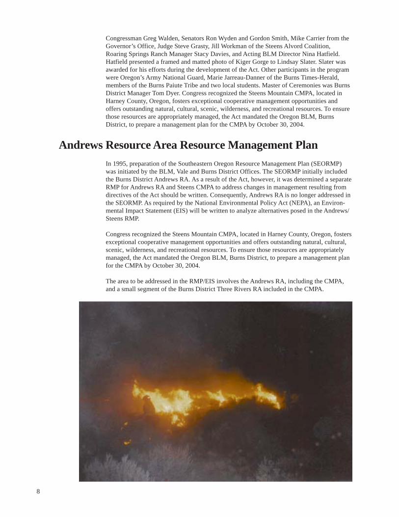
Wildfire Rehabilitation The Burns Interagency Fire Zone, comprised of the Burns District of the BLM, Emigrant Creek Ranger District of the Malheur National Forest, and the Oregon Department of Forestry, had one of its busiest fire seasons in recent years. The fire zone initial attacked 219 fires that burned 65,500 acres. However, three of those fires totaled just over 60,000 acres.
The Big Stick Fire was ignited by lightning in the late afternoon on July 4. This fire burned 9,600 acres of Wyoming and basin big sagebrush plant communities. Seven days later lightning ignited the Double O Fire which grew to approximately 1,800 acres. A joint fire rehabilitation plan was developed for these two fires. The main goal of the rehabilitation plan was to reestablish perennial plant species throughout the two burned areas. Cheatgrass has made a significant inroad in the plant communities and almost totally dominated the Double O Fire plant communities. There was also an effort to reestablish woody plants in both these areas. The size of the fires and limited dispersal distance of sagebrush seed probably would increase the time until sagebrush become prominent in the plant communities. This has a significant influence on many wildlife species that depend on sagebrush for either part or all of their life cycle. Hopefully, planting sagebrush and rabbitbrush will help reduce the time needed for woody plants to establish.
Four fires were discovered in the Steens Mountain Wilderness Area. The two largest fires were 10 and 270 acres. The other two fires were less than 5 acres and extinguished with very minimal action by the BLM. The two larger fires required more intensive action because of their proximity to the South Steens Campground. Minimal impact suppression tactics were employed on these two fires. Suppression action will continue until a Wildland Fire Use Plan can be developed after the completion of the Andrews/Steens RMP. However, an interim fire management plan has been developed and approved and all suppression actions will utilize the minimum tool policy.
Noxious Weed Program During 2000 and 2001, the District Integrated Weed Management Program actively participated in the ongoing Harney County Weed Management Partnership. This partnership tries to focus and coordinate the management of noxious weeds throughout all the area agencies. These include Harney County Weed Control, Oregon Department of Agriculture, BLM, FS, Malheur National Wildlife Refuge, Agriculture Research Service Experiment Station, Oregon Department of Transportation (ODOT), the cities of Burns and Hines, Soil and Water Conservation District (SWCD), Oregon Department of Fish and Wildlife (ODFW), and Oregon State University (OSU) Extension. Activities conducted throughout the year include Education/Awareness Trainings for agency staff and the public, both formal and informal; coordinated inventory and monitoring; coordinated control efforts including cost-share opportunities; and coordinated research and demonstration projects and plots. This Partnership has proven to be a very effective way to conduct weed management in our area and is anticipated to continue through FY02 and beyond.
Highlights of the Partnership in FY01 include:
* Acquisition and outfitting of our new Weed Awareness Mobile: a 25-foot-long office trailer decked out as a complete walk-through Weed Experience!
10
* Continued development of a Statewide Weed Curriculum for grades K-12.
* Aerial (helicopter) inventory of 87,000 acres of checkerboard BLM and private lands, most notably looking for dalmatian toadflax.
* Acquisition of $25,000 in grant money for the County Cost Share program, which will facilitate projects in areas of cooperative weed control projects.
* Initiation of several cooperative research projects: a) to quantify impacts of various herbicides for medusahead control on associated vegetation, particularly forbs; b) to evaluate livestock grazing treatments for perennial pepperweed management; and c) continuing research evaluating plant species for road rights-of-way revegetation.
* Demonstration plots for evaluating control methods for Russian knapweed and dalmatian toadflax.
* Several coordinated control projects throughout the County including road rights-ofway and areas of mixed ownership.
The following weed program activities occurred on the Burns District:
FY00
79,000 acres inventoried, including extensive inventories of previous year wildfires
1,200 acres of treatments applied, including both manual and chemical controls (hand application)
Approximately 640 acres of treatments were evaluated
FY01
107,560 acres inventoried - including 68 miles of BLM-maintained roads in remote areas of the Andrews RA
1,349 acres of treatments applied, both manual and chemical controls. Benefits of treatments accomplished include 4 miles of riparian habitat and 615 acres of wetland habitat.
Approximately 2,620 acres of treatments were evaluated.
Weed management plans for FY02 include approximately 1,200 acres of treatment, 50,000 acres of inventory, and 1,500 acres of treatments evaluated.
Wild Horse and Burro Program
The Burns District is the lead office for Oregon and Washington’s wild horse adoption and gathering program. The District manages eight wild horse Herd Management Areas (HMAs) and provides support for the management of 11 others that are located in the Lakeview, Vale, and Prineville Districts. In addition, one herd is managed by the Ochoco National Forest near Prineville and a second near Dayville is managed jointly by the Prineville District and the Malheur National Forest.
Currently, approximately 2,750 horses are on the range in Oregon’s 21 HMAs. Horse numbers increase annually at a rate of 18 to 20 percent. Each herd is gathered every 3 to 5
11

years, depending on range conditions and actual population numbers, which are determined by range studies and periodic census.
Since the 2000 planning update, the Burns District removed 69 horses from the Alvord-Tule Springs HMA (January 2001); and 325 horses from the Warm Springs HMA (September 2001). These animals and 823 other horses gathered in the Lakeview and Vale Districts were delivered to the Burns Wild Horse Corrals, and were made available to the public through the Wild Horse Adoption Program.
During the next year, the Burns District plans to remove approximately 34 horses from the Heath Creek-Sheepshead HMA. Another 745 head are planned for removal from other districts in Oregon.
Oregon’s wild horses are known nationally for their quality and color, and are very popular with the Nation’s adopters. Each of Oregon’s herds have their own unique characteristics. Some examples are the South Steens pintos, Hog Creek and Palomino Butte palominos, Warm Springs Appaloosas, Stinkingwater horses with draft blood, and the highly sought after Kiger Mustangs in the Kiger and Riddle HMAs.
Gathered excess animals are available to qualified adopters through adoption events held at the Burns Wild Horse Corrals and in cities throughout Oregon and Washington. Burros from the southwest are also available at some Oregon adoption events. Eight adoption events were held in 2000 and ten were held in 2001. In 2000, 373 horses and burros were adopted in Oregon and Washington, while other animals were transported to other states for adoption. In 2001, 492 horses were adopted.
BLM is now using competitive bidding to establish adoption fees. Competitive bidding replaces the lottery method used in past years. Through the lottery method, adopters had to rely on “the luck of the draw” for horse selection. Competitive bidding allows all animals to be available to all adopters present, with animals adopted to the highest bidders. The average adoption fee during the past year for Oregon events was about $190 per animal.
Wild horse gentling demonstrations are held at most adoption events. These demonstrations not only provide adopters an opportunity to learn about a variety of gentling and training techniques, but also generate a lot of interest in the adoption program.
Burns District is responsible for coordinating 7 to 10 adoption events that are held at various cities in Oregon and Washington.
Animals are also available to adopters through “Walk Up” appointments at the Burns Corrals for the minimum adoption fee of $125 per animal.
Horse enthusiasts are finding that wild horses have a place among America’s horses, and they perform admirably in a variety of situations. Adopters report that the gentling process is occasionally challenging, but always rewarding. Wild horses are commonly used for pleasure and trail animals, packing, ranch work, and occasionally in competitive events. They are known for their intelligence, endurance, and agility.
Information about the Wild Horse Program is available through the internet at the following sites:
National Wild Horse and Burro Web Page: http://www.blm.gov/whb Burns District Home Page: http://www.or.blm.gov/Burns/ burns_wild_horses_and_burros.htm
Adoption applications and information may also be obtained by calling the Burns District Office at (541) 573-4456.
12
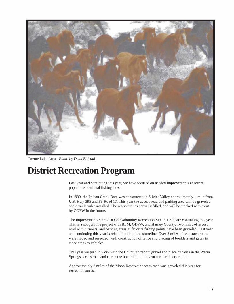
Coyote Lake Area - Photo by Dean Bolstad
District Recreation Program Last year and continuing this year, we have focused on needed improvements at several popular recreational fishing sites.
In 1999, the Poison Creek Dam was constructed in Silvies Valley approximately 1-mile from U.S. Hwy 395 and FS Road 17. This year the access road and parking area will be graveled and a vault toilet installed. The reservoir has partially filled, and will be stocked with trout by ODFW in the future.
The improvements started at Chickahominy Recreation Site in FY00 are continuing this year. This is a cooperative project with BLM, ODFW, and Harney County. Two miles of access road with turnouts, and parking areas at favorite fishing points have been graveled. Last year, and continuing this year is rehabilitation of the shoreline. Over 8 miles of two-track roads were ripped and reseeded, with construction of fence and placing of boulders and gates to close areas to vehicles.
This year we plan to work with the County to “spot” gravel and place culverts in the Warm Springs access road and riprap the boat ramp to prevent further deterioration.
Approximately 3 miles of the Moon Reservoir access road was graveled this year for recreation access.
13
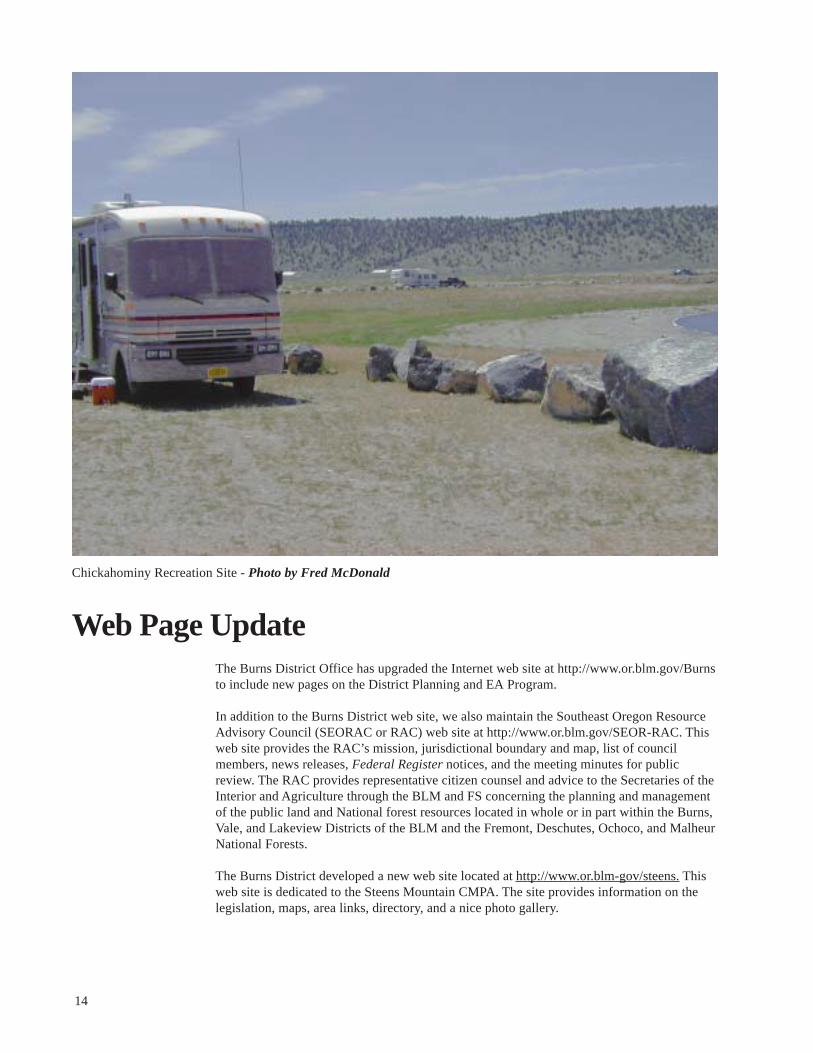
Chickahominy Recreation Site - Photo by Fred McDonald
Web Page Update The Burns District Office has upgraded the Internet web site at http://www.or.blm.gov/Burns to include new pages on the District Planning and EA Program.
In addition to the Burns District web site, we also maintain the Southeast Oregon Resource Advisory Council (SEORAC or RAC) web site at http://www.or.blm.gov/SEOR-RAC. This web site provides the RAC’s mission, jurisdictional boundary and map, list of council members, news releases, Federal Register notices, and the meeting minutes for public review. The RAC provides representative citizen counsel and advice to the Secretaries of the Interior and Agriculture through the BLM and FS concerning the planning and management of the public land and National forest resources located in whole or in part within the Burns, Vale, and Lakeview Districts of the BLM and the Fremont, Deschutes, Ochoco, and Malheur National Forests.
The Burns District developed a new web site located at http://www.or.blm-gov/steens. This web site is dedicated to the Steens Mountain CMPA. The site provides information on the legislation, maps, area links, directory, and a nice photo gallery.
14

Burns District Rangeland Program Summary
Introduction
The purpose of the Rangeland Program Summary (RPS) Update is to outline the progress being made in implementing the rangeland management objectives of each Resource Area as identified in the current land use plans.
Interested Publics
Following issuance of this RPS Update, there will be a 30-day comment period for the public to request affected interest status. If you believe that any of the future actions indicated in the RPS Update may affect your interests, contact the BLM Burns District Manager in writing by 30XXXXXXXXXXX, 2002. You must advise which specific future actions concern you, the allotment or allotment(s) involved, and your reason for believing that you have an interest that can be affected by future actions. The District Manager will provide those determined to have an affected interest with an opportunity to participate in the development of the livestock grazing management plans in the identified allotments.
Three Rivers Resource Area
New Allotment Numbers
In anticipation of implementing a new grazing billing system in FY01, several allotment numbers were changed throughout the State to ensure that each allotment has a unique number. The following allotment number changes have been made.
Allotment Name Old Number New Number
Beaver Creek 5213 5600 Beckley Home 5211 5598 Burnt Flat 5313 5604 Catterson FFR 5203 5586 Coleman Creek 5201 5592 Coyote Creek 5207 5595 Crane 5209 5597 Emmerson 5208 5596 Hamilton 5214 5601 Mahon Ranch 5212 5599 Manning Field 5107 5587 Quier FFR 5216 5602 Rattlesnake FFR 5113 5591 Reed FFR 5110 5588 Slocum 5204 5593 Smith FFR 5112 5590 Temple’s FFR 5111 5589 Venator 5205 5594 Virginia Valley FFR 5311 5603
15

FY 2002 Plans
During FY02, the monitoring data will be analyzed, interpreted, and evaluated to document the progress of management to meet resource objectives for the following allotments. An assessment of Standards for Rangeland Health will be included in the evaluation.
Allotment Name Allotment Number Allotment Name Allotment Number
Cow Creek 5106 Griffin 5548 Princeton 5301 Wheeler Basin 5564 Smyth-Kiger 5331 Lamb Ranch 5571 Muddy Creek 5506 School House 5575 Clarks River 5512 Lower Pine 5576 Shelley 5513 Slocum 5593 Mule Creek 5515 Crane 5597 Birch Creek 5516 East Warm Springs 7001 Mahon Cree 5534 West Warm Springs 7002 Alder Creek 5536 West Wagontire 7004 Riverside 5538 Sand Hollow 7020 Sunshine Field 5545 Silvies River 7033 Lake Field 5547 Silvies Canyon 7053
Allotment Management Plans (AMPs) will be developed or revised for the following allotments:
Lime Kiln 5103 Soldier Creek 5104 Cow Creek 5106 House Butte 5529 Venator 5594 Crane 5597 Hamilton 5601 West Warm Springs 7002 Palomino Butte 7019 Hayes 7036
Grazing Permit/Lease Renewals
Grazing permits or leases are scheduled to expire between February 28, 2002 and September 30, 2006, in the following allotments. Allotments are listed if the permit/lease for any permittee is expiring. There may be other permittees in an allotment whose permits or leases are not expiring. The required National Environmental Policy Act (NEPA) analysis will be prepared prior to renewal of these permits. There were 10 permits reissued in FY01.
Allotments with permits expiring in 2002 are:
#5301 - Princeton #5515 - Mule Creek #5536 - Alder Creek #5302 - Big Bird #5516 - Birch Creek #5542 - Marshall FFR #5316 - Virginia Valley #5517 - Otis Mountain #5544 - Brooks Field #5317 - Hatt Butte #5519 - Big Upson #5545 - Sunshine Field #5322 - Briggs’ FFR #5522 - Cottonwood Creek #5547 - Lake Field #5325 - Marshall Diamond #5523 - Tub Springs/Hart #5549 - Howard’s FFR #5505 - Little Muddy Creek #5525 - Mill Gulch #5550 - Jordan’s FFR #5507 - Wolf Creek #5526 - Chalk Hills #5554 - J. Francis Miller FFR #5508 - Baker-Knowles #5528 - Cooler #5564 - Wheeler Basin #5511 - Moffet Table #5529 - House Butte #5565 - Upton Mountain
16

#5575 - Schoolhouse #5587 - Manning Field #5590 - Smith FFR #5598 - Beckley Home #7003 - East Wagontire
#7006 - Rimrock Lake #7010 - Claw Creek #7021 - Weaver Lake #7022 - Dog Mountain #7026 - Horton Mill
Allotments with permits expiring in 2003 are:
#5101 - Devine Ridge #5105 - Camp Harney #5106 - Cow Creek #5221 - West Davies #5223 - East Davies #5301 - Princeton #5306 - Rocky Ford #5316 - Virginia Valley #5325 - Marshall Diamond #5502 - Rock Creek
#5504 - State Field #5518 - Newell Field #5520 - Little Upson #5534 - Mahon Creek #5563 - Arnold’s FFR #5584 - Poison Creek #5585 - Harney Crane #5588 - Reed FFR #5597 - Crane #7002 - West Warm Springs
Allotments with permits expiring in 2004 are:
#4126 - Abraham’s Draw #5507 - Little Muddy Creek #5524 - Dawson Butte #5529 - House Butte #5532 - Mountain #5535 - Miller Canyon #5539 - W&C Blaylock FFR #5540 - Luce Field #5543 - Devine Flat Field
#5546 - Druitt Field and FFR #5551 - Lillard’s FFR #5552 - Miller FFR A #5553 - Miller FFR B #5560 - Vickers’ FFR #5571 - Lamb Ranch #5600 - Beaver Creek #7002 - West Warm Springs #7005 - Second Flat
Allotments with permits expiring in 2005 are:
#4138 - White #5202 - Hunter #5203 - Catterson #5303 - Dry Lake #5503 - Pine Creek #5512 - Clark’s River #5529 - House Butte #5532 - Mountain #5537 - Buck Mountain
#5556 - Pine Creek FFR #5566 - Texaco Basin #5593 - Slocum #7001 - East Warm Springs #7004 - West Wagontire #7009 - Dry Lake #7016 - Juniper Ridge #7025 - Gouldin #7030 - Skull Creek
Allotments with permits expiring in 2006 are:
#5003 - Malheur Slough #5101 - Devine Ridge #5102 - Prather Creek #5217 - Thompson FFR #5218 - Bennett FFR #5301 - Princeton #5306 - Rocky Ford #5309 - Happy Valley #5310 - Riddle Mountain #5316 - Virginia Valley #5323 - Clemens’ FFR #5324 - Riddle FFR
#5330 - Barnes Well #5331 - Smyth-Kiger #5510 - Jones Dripp #5511 - Moffet Table #5513 - Shelley #5514 - Coal Mine Creek #5527 - Riverside FFR #5532 - Mountain #5533 - Buchanan #5536 - Alder Creek #5537 - Buck Mountain #5538 - Riverside
#7028 - Stinger Creek #7038 - Curry Gordon #7061 - Bulger #7062 - Capehart Lake
#7007 - Hat Butte #7026 - Horton Mill #7028 - Stinger Creek #7029 - Spring Creek #7030 - Skull Creek #7034 - Scat Field #7036 - Hayes #7043 - Lone Pine #7049 - Forks of Poison Creek #7052 - Lone Pine Fields
#7019 - Palomino Buttes #7023 - West Sagehen #7024 - East Sagehen #7026 - Horton Mill #7033 - Silvies River #7040 - Landing Creek #7046 - Baker Hill
#7032 - Hotchkiss #7043 - Lone Pine #7044 - Cowing #7047 - Peabody #7048 - Varien Canyon #7049 - Forks of Poison Creek #7051 - Sawtooth MNF #7059 - Carp #7063 - Roundtop Butte
#5561 - Wilber FFR #5568 - Byron’s FFR #4473 - Beaver FFR #5577 - Cooper Field FFR #5586 - Catterson Sec. 13 #5589 - Temple FFR #5595 - Coyote Creek #5596 - Emmerson #5599 - Mahon Ranch #5601 - Hamilton #5604 - Burnt Flat #7043 - Lone Pine
#5326 - Jenkins’ N. Lake #5541 - Home Ranch Exclosure #7045 - Whiting #5327 - Jenkins’ B. Flat #5548 - Griffin FFR #5328 - Fisher FFR #5559 - Sword’s FFR
17

FY00 and 01 Accomplishments
Allotment Allotment Number Name Category* Implementation Progress
*I = Improve; M = Maintain; C = Custodial 4097 Trout Creek I Two reservoirs were constructed in this allotment to improve livestock
distribution and draw livestock away from riparian areas.
4143 Silvies I Two and one-half miles of boundary fence between the BLM and the FS were reconstructed.
5101 Devine M An allotment management evaluation was conducted to analyze, interpret, and Ridge evaluate whether or not present management is meeting resource objectives.
Results indicate that the grazing system outlined in the AMP has not been followed consistently; however, the grazing treatments have been meeting objectives in two of the pastures. Utilization levels have been too high in the third pasture. Forage production overall in the allotment is sufficient to meet forage demand. The assessment of Standards for Rangeland Health found that the standards for upland watershed function and ecological processes were being met. The standards for riparian watershed function, water quality, and native species were not met; however, the determination was that livestock was not a significant factor. The evaluation recommends limiting early spring use to keep utilization levels within management limits. It is recommended that the selective management category be changed to ‘I.’
5105 Camp I The AMP was revised to incorporate the recommendations from the allotment Harney management evaluation and address the conflicts and concerns identified in
the Three Rivers RMP. The conflicts and concerns include water quality, erosion, riparian and aquatic habitat, and Special Status species. The objectives developed for the AMP are to:
•maintain all seral stages in current status to provide a diversity of habitat types, conditions and forage requirements in all of the pastures during the next four grazing cycles, •maintain habitats for Special Status species: bald eagle (winter roosts), sage grouse (brood rearing), redband trout and Malheur mottled sculpin (yearround life cycle), •cause an upward (improve) trend in the fair condition riparian habitat in Coffeepot Creek and Mill Creek and maintain the good riparian conditions along Rattlesnake Creek during the next four grazing cycles.
A grazing system has been designed which will meet these objectives. Key forage species and utilization levels have been identified for each pasture.
5202 Hunter M The AMP was revised to incorporate the recommendations from the allotment management evaluation. The objective developed for the AMP is to:
•maintain mid and late seral stage range conditions in the stiff sagebrush, low sagebrush, and mountain big sagebrush range sites across the allotment.
A grazing system has been designed which will meet this objective. Key forage species and utilization levels have been identified for the allotment.
5302 Big Bird M An allotment management evaluation was conducted to analyze, interpret, and evaluate whether or not present management is meeting resource objectives.
18

Allotment Allotment Number Name Category* Implementation Progress
*I = Improve; M = Maintain; C = Custodial Results indicate that the resource objective identified in the AMP has not been met. While the grazing system conforms to the Guidelines for Grazing Management, the stocking rate is above the carrying capacity. This allotment has been seeded to crested wheatgrass and brush establishment and cheatgrass invasion have decreased carrying capacity. The allotment has not been fully stocked during most of the evaluation period. The assessment of Standards for Rangeland Health found that the standards for riparian watershed function and water quality are not present on the allotment. The standards for upland watershed function, ecological processes and Special Status species have been met. The evaluation recommends a 25 percent stocking rate reduction and cheatgrass and brush control.
5310 Riddle I A reservoir was constructed to improve livestock distribution. Two aspen Mountain groves were rejuvenated by having the junipers removed and protective
fencing installed to allow for establishment of new aspen trees.
5503 Pine Creek I Western junipers were cut from 46 acres to reduce competition with other vegetation and improve rangeland condition.
5511 Moffet Table I A prescribed fire was conducted in the fall of 2000 to reduce western juniper in a mountain big sagebrush type. The juniper reduction will enhance big game habitat and improve vigor of other vegetation. Approximately 1,100 acres were burned.
5514 Coal Mine I An allotment management evaluation was conducted to analyze, interpret, and Creek evaluate whether or not present management is meeting resource objectives.
Results indicate that the resource objective identified in the AMP for vegetative resources has been met. The objective for livestock forage production has not been met; however, the evaluation found that the grazing system outlined in the AMP has not been followed closely. The vegetation is in good condition and trend is up. The assessment of Standards for Rangeland Health found that the standards for upland watershed function, ecological processes, and Special Status species have been met. The riparian watershed function and water quality issues are not present. The evaluation recommends revising the AMP, following the grazing system more closely, and reducing stocking rate to balance with carrying capacity.
5529 House Butte I An allotment management evaluation was conducted to analyze, interpret, and evaluate whether or not present management is meeting resource objectives. Results indicate that three of the resource objectives identified in the AMP have not been met and one has been. Trend was found to be static or down. The main factor in not meeting the resource objectives is the result of a trial stocking rate increase during the evaluation period. The assessment of Standards for Rangeland Health found that the standards for upland watershed function, ecological processes, and Special Status species were met. The riparian watershed function and water quality issues are not present. The evaluation recommends reducing the stocking rate to active use to balance with carrying capacity and revising the AMP to formalize a grazing system.
5596 Emmerson M An allotment management evaluation was conducted to analyze, interpret, and evaluate whether or not present management is meeting resource objectives. Results indicate that the resource objectives identified in the AMP have been
19
Allotment Allotment Number Name Category* Implementation Progress
*I = Improve; M = Maintain; C = Custodial met. The grazing system has been followed and no revision of the AMP is necessary. The assessment of Standards for Rangeland Health found that the standards for upland watershed function, ecological processes, and Special Status species were met. The riparian watershed function and water quality issues are not present. The stocking rate is well below carrying capacity.
5604 Burnt Flat I An allotment management evaluation was conducted to analyze, interpret, and evaluate whether or not present management is meeting resource objectives. Results indicate that the resource objectives identified in the AMP have been met. The assessment of Standards for Rangeland Health found that the standards for upland watershed function, ecological processes, and Special Status species were met. The riparian watershed function and water quality issues are not present. The evaluation recommends no changes in management at this time.
7003 East Wagontire I An allotment management evaluation was conducted to analyze, interpret, and evaluate whether or not present management is meeting resource objectives. Results indicate that the resource objectives identified in the AMP have been met. The assessment of Standards for Rangeland Health found that the standards for upland watershed function, ecological processes, water quality, and Special Status species were met. The riparian watershed function and water quality issues are not present. The evaluation recommends revising the AMP to incorporate a grazing system to address playa management.
7009 Dry Lake I Three hundred twenty-four acres of juniper were cut in this allotment to release brush, grass, and forbs.
7014 Badger Springs M An allotment management evaluation was conducted to analyze, interpret, and evaluate whether or not present management is meeting resource objectives. Results indicate that the resource objectives identified in the AMP have been met. The assessment of Standards for Rangeland Health found that the standards for upland watershed function, ecological processes, and Special Status species were met. The riparian watershed function and water quality issues are not present. The evaluation recommends no changes in management at this time.
7015 Second Flat I An allotment management evaluation was conducted to analyze, interpret, and evaluate whether or not present management is meeting resource objectives. Results indicate that the resource objectives identified in the AMP have been met. The assessment of Standards for Rangeland Health found that the standards for upland watershed function, ecological processes, and Special Status species were met. The riparian watershed function and water quality issues are not present. The evaluation recommends no changes in management at this time.
7016 Juniper Ridge M An allotment management evaluation was conducted to analyze, interpret, and evaluate whether or not present management is meeting resource objectives. Results indicate that the resource objectives identified in the AMP have been met. The assessment of Standards for Rangeland Health found that the standards for upland watershed function, ecological processes, and Special Status species were met. The riparian watershed function and water quality issues are not present. The evaluation recommends no changes to the grazing system at this time and changing the selective management category to ‘M.’
20

Allotment Allotment Number Name Category* Implementation Progress
*I = Improve; M = Maintain; C = Custodial 7018 Silver Lake M An allotment management evaluation was conducted to analyze, interpret, and
evaluate whether or not present management is meeting resource objectives. Results indicate that the resource objectives identified in the AMP have been met. The assessment of Standards for Rangeland Health found that the standards for upland watershed function, ecological processes, and Special Status species were met. The riparian watershed function and water quality issues are not present. The evaluation recommended changing the selective management category to ‘M’ and revising the grazing system in the AMP. An AMP was developed to incorporate the recommendation from the allotment management evaluation and address conflicts and concerns identified in the Three Rivers RMP. The conflicts and concerns include wetland habitat, Special Status species, playa habitat, and range condition. The objectives are to:
•maintain all seral stages in current status to provide a diversity of habitat types, conditions and forage requirements in all of the pastures during the next four grazing cycles, •maintain the availability and production of upland forbs for sage grouse from May to mid-July during the next 10 years, while preventing significant risk to the western snowy plover during its nesting period between May 1 to July 31, each year around Silver Lake.
A grazing system has been developed which will meet these objectives. Key forage species and utilization levels have been identified for each pasture.
7021 Weaver Lake I An allotment management evaluation was conducted to analyze, interpret, and evaluate whether or not present management is meeting resource objectives. Results indicate that the resource objectives identified in the AMP have been met. The assessment of Standards for Rangeland Health found that the standards for upland watershed function, ecological processes, and Special Status species were met. The riparian watershed function and water quality issues are not present.
7025 Gouldin I An allotment management evaluation was conducted to analyze, interpret, and evaluate whether or not present management is meeting resource objectives. Results indicate that the resource objectives identified in the AMP have been met. The assessment of Standards for Rangeland Health found that the standard for upland watershed function is not being met due to erosion caused by Off-Highway vehicle use in the allotment. The standards for ecological processes and Special Status species are being met. The riparian watershed function and water quality issues are not present. The evaluation recommends modifying the grazing system to allow for growing season rest at least 1-year out of 3.
7030 Skull Creek I Junipers were cut in two areas in the allotment to reduce competition with big sagebrush, bitterbrush, and ponderosa pine. The units were approximately 250 and 330 acres.
7036 Hayes I A spring was reconstructed in this allotment to improve the water source for livestock.
21

Allotment Allotment Number Name Category* Implementation Progress
*I = Improve; M = Maintain; C = Custodial
7058 Narrows I An allotment management evaluation was conducted to analyze, interpret, and evaluate whether or not present management is meeting resource objectives. Results indicate that the resource objectives identified in the AMP have been met. The assessment of Standards for Rangeland Health found that the standards for upland watershed function, ecological processes, and Special Status species were met. The riparian watershed function and water quality issues are not present. The evaluation recommended revising the grazing system in the AMP. An AMP was developed to incorporate the recommendation from the allotment management evaluation and address conflicts and concerns identified in the Three Rivers RMP. The conflicts and concerns include range condition and Special Status species (sage grouse, long-billed curlew, Malheur wirelettuce). The objective is to:
•maintain the good condition seedings in the Middle and South Pastures. Continue the upward trend in the native plant communities in the North Pasture.
A grazing system has been developed which will meet these objectives. Key forage species and utilization levels have been identified for each pasture.
7063 Round Top I An allotment management evaluation was conducted to analyze, interpret, and Butte evaluate whether or not present management is meeting resource objectives.
Results indicate that the resource objectives identified in the AMP have been met. The assessment of Standards for Rangeland Health found that the standards for upland watershed function, ecological processes, were met and the standard for Special Status species was not met, but the determination is that livestock are not a significant factor. The riparian watershed function and water quality issues are not present. The evaluation recommended revising the grazing system in the AMP.
22
Andrews Resource Area
FY02 Plans
During FY02, the monitoring data will be analyzed, interpreted, and evaluated to document the progress of management to meet resource objectives for the following allotments. An assessment of Standards for Rangeland Health will be included in the evaluation.
Allotment Name Allotment Number
Pollock 6011 Alvord 6012 Sandhills 6016 Mann Lake 6026 Chimney 6033
AMPs will be developed or revised for the following allotments:
Allotment Name Allotment Number
Pollock 6011 Lavoy Tables 6031
Grazing Permit/Lease Renewals
One grazing permit, Mann Lake Allotment, was renewed in FY01. Grazing permits or leases will expire between February 28, 2002 and September 30, 2006, in the following allotments. Allotments are listed if the permit/lease for any permittee is expiring. There may be other permittees in an allotment whose permits or leases are not expiring.
Allotments with permits expiring in 2002 are:
#6011 - Pollock #6031 - Lavoy Tables #6116 - Northrup FFR #6012 - Alvord #6032 - Krumbo Mountain #6118 - Lupher FFR #6016 - Sandhills #6035 - Fields Basin #6119 - Pollock FFR #6018 - Tule Springs #6036 - Penland #6127 - Kueny Ranch FFR #6027 - Carlson Creek #6040 - Stonehouse #6028 - Miner’s Field #6108 - Henricks FFR
Allotments with permits expiring in 2003 are:
#6007 - Ruby Springs #6033 - Chimney #6117 - Kaser FFR
Allotments with permits expiring in 2004 are:
#6001 - North Catlow #6023 - Hammond #6111 - Dunbar FFR #6005 - Mud Creek #6025 - Hardie Summer #6114 - Rock Creek FFR #6007 - Ruby Springs #6029 - Keg Springs #6128 - Konek FFR #6010 - East Ridge #6030 - Reicken’s Corner #6130 - Scharff FFR #6015 - Trout Creek Mountain #6100 - Hammond FFR
23

Allotments with permits expiring in 2005 are:
No permits expire this year.
Allotments with permits expiring in 2006 are:
#6002 - South Steens #6125 - Roaring Springs FFR
24

FY00 and 01 Accomplishments
Allotment Allotment Number Name Category* Implementation Progress
*I = Improve; M = Maintain; C = Custodial 6001 North Catlow I On July 12, 2000, 805 acres of public land burned in the Rock Creek Pasture
of North Catlow Allotment. The rehabilitation of this fire was analyzed in EA OR-026-00-35. This resulted in reseeding 805 acres with plant species best adapted to that specific site. The area will have a minimum of two growing seasons rest from livestock grazing.
6002 South Steens I The actions outlined in the AMP/EA to accomplish resource objectives continue to be implemented, as well as the continuing implementation of the Catlow Redband Trout and Tui Chub Conservation Agreement and Strategy. The upper elevation pastures, private and public (V-Lake, and Telephone Field) continue to be rested from livestock grazing to prepare for prescribed burns. These pastures, as well as the Blitzen and Penland Pastures, were rested from grazing again in 2000. In 2001, the Penland Pasture will be grazed after seed ripe. Those portions of Blitzen Pasture which do not have access to the public land within the Donner und Blitzen Wild and Scenic River corridor will also be grazed. The Act designated all of the Blitzen Pasture and most of the Penland Pasture as wilderness. Livestock grazing will be phased out of this area within 3 years of completion of the land exchange authorized by the law. The 10-year grazing permit AUM changes and the allotment boundary adjustments will be implemented at this time. The Lauserica fence and Stephens extension fence were completed during the summer of 2000, following the withdrawal of the appeal to the Interior Board of Land Appeals (IBLA) by Oregon Natural Desert Association (ONDA). No prescribed burns were completed during 2000, but were rescheduled for 2001.
On July 12, 2000, 4,817 acres of public land and 3,940 acres of private land burned in the South Catlow Pasture of South Steens Allotment. The possibilities of rehabilitation of this fire were analyzed in EA OR-026-00-35. This resulted in reseeding 8,757 acres of public and private lands in cooperation with Roaring Springs Ranch, with plant species best adapted to that site. The area will have a minimum of two growing seasons rest from livestock grazing.
6003 Fish Creek- I The evaluation and analysis of rangeland monitoring and determination of Big Indian conformance with the Standards for Rangeland Health is currently being
conducted. The 10-year grazing permit expired for this allotment on February 28, 2000. The 10-year grazing permit on this allotment will be reissued under Section 123 of Public Law 106-113. The court order from ONDA v. Green Civil No. 95-2013 HA, which closed public land within the Donner und Blitzen Wild and Scenic River corridor to grazing until the impacts of grazing are analyzed in an EIS, continues to be in effect. As a result Newton Cabin Pasture and Blitzen Meadows have not been grazed since 1996 and continue to be closed to livestock grazing. The Act designated the area within this allotment as wilderness. Livestock grazing will be phased out of this allotment 3 years after completion of the land exchange, authorized in this law. The 10-year grazing permit will be cancelled at this time.
6008 Krumbo I The evaluation and analysis of rangeland monitoring and determination of conformance with the Standards for Rangeland Health. The AMP was signed January 10, 2000.
25

Allotment Allotment Number Name Category* Implementation Progress
*I = Improve; M = Maintain; C = Custodial 6010 East Ridge I The East Ridge prescribed burns and juniper cuts (EA OR-026-99-19) are
continuing in the mid-canyon of Kiger Gorge. During 2000, 141 acres of juniper were cut to prepare the area for reintroduction of fire. Prescribed burns of approximately 1,000 acres of public land on the east side of the mid-canyon are scheduled for October 2001. The Act designated the head of Kiger Gorge as wilderness. Livestock will be phased out of this wilderness, 3 years after completion of the land exchange authorized by this law. The 10-year grazing permit, AUM adjustments, and allotment boundary adjustments will be implemented at that time.
6015 Trout Creek I Management under the current AMP continues to contribute to an upward Mountain trend in riparian areas. Completion of Proper Functioning Condition (PFC)
Assessment in 1999 found the majority of streams in the allotment to be in PFC. An October 20, 1999, tour with interested publics resulted in favorable comments on the allotment condition and trend. In 2000, 3.2 miles of fence were realigned on the headwaters of East Fork of Big Trout Creek. This project will serve to further enhance riparian conditions in the East Fork and Headwaters Pastures. An EA was completed in June 2000, which analyzes the impacts of construction of a 2-mile division fence in the Upper Antelope Pasture. This fence is intended to improve early season use in this seeding, thereby further reducing grazing pressure on higher elevation native pastures. Both projects have been completed.
6020 Pueblo-Lone I During the winter of FY00, 1,000 acres in the Colony Seeding Pasture were Mountain disced and reseeded to a mixture of crested wheatgrass, forage kochia, Great
Basin wildrye, and fourwing saltbush. The pasture will be rested from grazing for two growing seasons following this seeding rehabilitation effort. A fence was constructed to exclude Tum Tum Lake from livestock grazing. Both projects were also identified in the AMP.
An assessment of the Rincon pipeline was completed in 2000, to determine possibilities for increased water efficiencies. This pipeline was built in the early 1960’s, and while functioning well, is due for maintenance and upgrading. The purpose of this effort is to improve overland water flow at Dip Spring, which supplies water to the pipeline. The pipeline was replaced as needed, and new troughs and storage tank installed.
Grazing use according to the Pueblo-Lone Mountain AMP continues to result in improved upland meadow and riparian conditions. Continued protection of Van Horn Creek from livestock use is contributing to improved riparian and aquatic conditions for the resident Lahontan cutthroat trout.
6026 Mann Lake I The evaluation and analysis of rangeland monitoring and determination of conformance with the Standards for Rangeland Health is currently being conducted.
6028 Miner’s Field I On August 3, 2000, a lightning-caused wildfire occurred (Alvord Peaks Fire) Allotment in the Bone Creek Field of Miner’s Field Allotment, approximately 60 acres
were reseeded with native species. The Bone Creek Field was rested from livestock grazing during 2000 and 2001. The Act, Section 113(3)(A)(B)(C) outlines the reallocation of available forage in the Miner’s Field Allotment.
26

Allotment Allotment Number Name Category* Implementation Progress
*I = Improve; M = Maintain; C = Custodial
6034 West Slope M A 3.8-mile allotment boundary fence is scheduled to be constructed in the summer of 2001 to improve riparian management on about 12 miles of McCoy Creek and its tributaries.
6040 Stonehouse The analysis and evaluation of monitoring studies were completed by the BLM during 1999. This evaluation determined that the current livestock management on this allotment was not in conformance with the Standards for Rangeland Health. The issues addressed in the evaluation, and subsequently in the EA/AMP, are riparian condition of upper Riddle Creek, Stonehouse Creek, fisheries, WSAs, upland range condition, sage grouse habitat, condition of wetland meadows, juniper encroachment, and the reintroduction of fire. The EA/AMP (EA OR-026-99-47) which resulted from this evaluation was circulated for public review during May of 2000. The EA was revised to analyze the prescribed burns and was available for public review during March 2001. The Finding of No Significant Impact (FONSI)/final decision was appealed to the IBLA and a “Stay of the Decision” requested. The issued appeal was the prescribed burning of 3,600 acres and 3 years of rest from livestock. Due to public comments received on this EA/AMP and the Act, the AMP will be coordinated with the SMAC and interested publics and reissued for public review in 2002 or 2003.
27
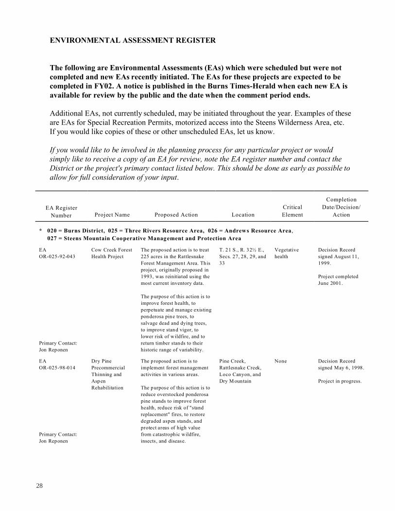
ENVIRONMENTAL ASSESSMENT REGISTER
The following are Environmental Assessments (EAs) which were scheduled but were not
completed and new EAs recently initiated. The EAs for these projects are expected to be
completed in FY02. A notice is published in the Burns Times-Herald when each new EA is
available for review by the public and the date when the comment period ends.
Additional EAs, not currently scheduled, may be initiated throughout the year. Examples of these
are EAs for Special Recreation Permits, motorized access into the Steens Wilderness Area, etc.
If you would like copies of these or other unscheduled EAs, let us know.
If you would like to be involved in the planning process for any particular project or would
simply like to receive a copy of an EA for review, note the EA register number and contact the
District or the project's primary contact listed below. This should be done as early as possible to
allow for full consideration of your input.
EA Register
Number Project Name Proposed Action Location
Critical
Element
Completion
Date/Decision/
Action
* 020 = Burns District, 025 = Three Rivers Resource Area, 026 = Andrew s Resource Area,
027 = Steens Mountain Coo perative Manag ement and Protection Area
EA Cow Creek Forest The proposed action is to treat T. 21 S., R. 32½ E., Vegetative Decision Record
OR-025-92-043 Health Project 225 acres in the Rattlesnake Secs. 27, 28, 29, and health signed August 11,
Forest Management Area. This 33 1999.
project, originally proposed in
1993, was reinitiated using the Project completed
most current inventory data. June 2001.
The purpose of this action is to
improve forest health, to
perpetuate and manage existing
ponderosa pine trees, to
salvage dead and dying trees,
to improve stand vigor, to
lower risk of w ildfire, and to
Primary Contact: return timber stands to their
Jon Reponen historic range of variability.
EA Dry Pine The proposed action is to Pine Creek, None Decision Record
OR-025-98-014 Precommercial implement forest management Rattlesnake Creek, signed May 6, 1998.
Thinning and activities in various areas. Loco Canyon, and
Aspen Dry M ountain Project in progress.
Rehabilitation The purpose of this action is to
reduce overstocked ponderosa
pine stands to improve forest
health, reduce risk of "stand
replacement" fires, to restore
degraded aspen stands, and
protect areas of high value
Primary Contact: from catastrophic wildfire,
Jon Reponen insects, and disease.
28
EA
EA
EA
Jim King
EA
Jim King
EA
Jim King
EA
Primary Contact:
Nora Taylor
Project completed
November 2000.
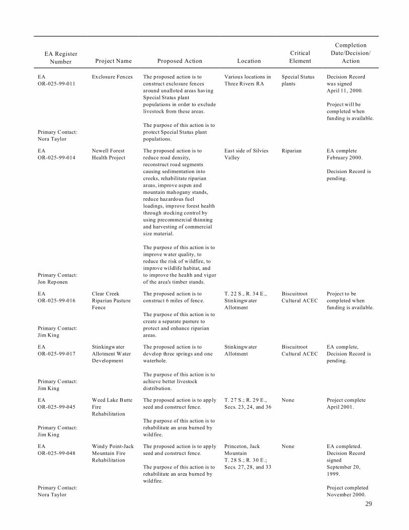
EA Register
Number Project Name Proposed Action Location
Critical
Element
Completion
Date/Decision/
Action
Exclosure Fences The proposed action is to Various locations in Special Status Decision Record
construct exclosure fences OR-025-99-011 Three Rivers RA plants was signed
around unalloted areas having April 11, 2000.
Special Status plant
populations in order to exclude Project will be
livestock from these areas. completed when
The purpose of this action is to
funding is available.
protect Special Status plant mary Contact: Pri
Nora Taylor populations.
Newell Forest The proposed action is to East side of Silvies Riparian EA complete
Health Project reduce road density, OR-025-99-014 Valley February 2000.
reconstruct road segments
causing sedimentation into Decision Record is
creeks, rehabilitate riparian pending.
areas, improve aspen and
mountain mahogany stands,
reduce hazardous fuel
loadings, improve forest health
through stocking control by
using precommercial thinning
and harvesting of commercial
size material.
The purpose of this action is to
improve water quality, to
reduce the risk of w ildfire, to
improve wildlife habitat, and
to improve the health and vigor mary Contact: Pri
Jon Reponen of the area's timber stands.
Clear Creek The proposed action is to T. 22 S., R. 34 E., Biscuitroot Project to be
Riparian Pasture construct 6 miles of fence. OR-025-99-016 Stinkingw ater Cultural ACEC completed when
Fence Allotment funding is available.
The purpose of this action is to
create a separate pasture to
protect and enhance riparianmary Contact: Pri
areas.
Stinkingw ater The proposed action is to Stinkingw ater Biscuitroot EA complete,
Allotment W ater develop three springs and one OR-025-99-017 Allotment Cultural ACEC Decision Record is
Development waterhole. pending.
The purpose of this action is to
achieve better livestock mary Contact: Pri
distribution.
Weed Lake Butte The proposed action is to app ly T. 27 S.; R. 29 E., None Project complete
Fire
Rehabilitation
seed and construct fence. OR-025-99-045 Secs. 23, 24, and 36 April 2001.
The purpose of this action is to
rehabilitate an area burned by mary Contact: Pri
wildfire.
Windy Point-Jack The proposed action is to app ly Princeton, Jack None EA completed.
Mountain Fire seed and construct fence. OR-025-99-048 Mountain Decision Record
Rehabilitation T. 28 S.; R. 30 E.; signed
The purpose of this action is to Secs. 27, 28, and 33 September 20,
rehabilitate an area burned by 1999.
wildfire.
29

EA Register
Number Project Name Proposed Action Location
Critical
Element
Completion
Date/Decision/
Action
EA Otis Mountain The proposed action is to use Otis Mountain Area; None Decision Record
OR-025-99-50 Ecosystem prescribed fire and mechanical T. 18 S.; R. 35 E., signed June 2000.
Restoration methods to reduce jun iper Secs. 26, 27, 28, 29,
Project encroachment. 30, 31, 32, 33, 34, *Long-term project
and 35 (15 years) (two of
The purpose of this action is to the five units have
restore sage grouse habitat and been treated, one
to improve and rehabilitate juniper cutting and
Primary Contact: aspen and mountain mahogany one prescribed fire)
Willie Street stands.
EA Three Rivers The proposed action is to use North of Hwy 20 ACEC, EA completed.
OR-025-00-04 Jun iper mechanical means to cut and in the riparian Decision Record
Management juniper. Stinkingwater and signed April 17,
Project Ridd le Mountain 2000.
The purpose of this action is to Areas
improve and restore sage This is a
grouse habitat, to improve and programmatic EA
restore aspen and mountain with a series of
Primary Contact: mahogany stands, and to projects.
Rudy H efter improve riparian areas.
EA Mountains The proposed action is to T. 23 S.; R. 35 E., Riparian EA was dropped.
OR-025-00-11 Grazing Use change season of use for Sec. 18
Project grazing in the Mountain and
Upton Mountain Allotments.
The purpose of this action is to
Primary Contact: improve upland range
Bill Andersen conditions.
EA Maintaining The proposed action is to Stinkingwater Herd ACEC EA D ecision
OR-025-0014 Viable
Populations of
gather wild horses. Management Area Record was signed
on July 26, 2000.
Wild Horses in The purpose of this action is to
Primary Contact: the Stinkingwater meet Appropriate Management Horses to be
Rudy H efter HMA Levels (AMLs). gathered FY02.
EA Devils Slide The proposed action is to T. 18 S.; R. 33½ E.; None EA Decision
OR-025-00-18 Fence construct 0.3-mile of fence. Sec. 26 Record signed
The purpose of this action is to
July 12, 2000.
Primary Contact: implement rest rotation and Project not funded
Leslie Richman improve cattle distribution. yet.
EA Programmatic EA The proposed action is to Districtwide WSAs, Wild EA is pending.
OR-020-00-19 for Commercial establish direction and and Scenic
Outfitting guidance for issuing ou tfitter Rivers (W SRs),
guide permits for other than ACECs, etc.
day-use permits.
The purpose of this action is to
establish criteria and identify a
Primary Contact: process for issuing commercial
Fred M cDonald outfitter/guide permits.
EA Maintaining The proposed action is to Warm Springs HMA None EA Decision
OR-025-00-23 Viable
Populations of
gather wild horses. Record signed
August 24, 2000.
Wild Horses in The purpose of this action is to
the Warm Springs meet AMLs. Gather completed
Primary Contact: Herd FY01.
Rudy H efter Management Area
30

Completion
EA Register Critical Date/Decision/
Number Project Name Proposed Action Location Element Action
EA
OR-025-00-24
Primary Contact:
Jeff Rose
EA
OR-025-00-25
Primary Contact:
Eric Haakenson
EA
OR-025-00-26
Primary Contact:
Jim King
EA
OR-025-00-27
Primary Contact:
Eric Haakenson
EA
OR-025-00-28
Primary Contact:
Scott Thomas
EA
OR-025-00-29
Primary Contact:
Rudy H efter
EA
OR-025-00-32
Primary Contact:
Holly LaChapelle
Bluebucket
Prescribed Burn
Canine-Crane
Creek Fence
South Clay Flat
Seeding and
Fence
Mahon
Creek/Poison
Creek Spring
Exclosure
Crystal Crane
Archaeology
Project
Hat Butte Wells
Jack M ountain
Communication
Site Management
Plan
The proposed action is to
reintroduce fire into the
forested areas on the south side
of Bluebucket Creek.
The purpose of this action is to
improve health and vigor of
overstory trees, to provide for
the establishment of ponderosa
pine, and to reduce the risk of
high intensity wildfires.
The proposed action is to bu ild
1-mile of fence.
The purpose of this action is to
achieve proper grazing on the
uplands, while preventing
overgrazing of riparian zones.
The proposed action is to
reseed and fence.
The purpose of this action is to
control weeds and plant other
vegetation.
The proposed action is to
develop springs and fence
them.
The purpose of this action is to
protect these riparian areas
from excessive grazing and
providing water away from the
springs.
The proposed action is
archaeological testing, series of
backhoe trenches.
The purpose of this action is
for archaeological research.
The proposed action is to drill
two wells for livestock water.
The purpose of this action is to
provide water providing better
distribution of livestock with
dependable water source.
The proposed action is the
management plan for existing
communication site.
The purpose of this action is to
provide an organized plan for
continued use of an existing
communication site and
potential increased use.
Bluebucket Creek
Coyote Creek
Allotment T . 26 S.,
R. 35 E., Sec. 32
Daw son Butte
Allotment
Miller Canyon
Allotment and
Poison Creek
Allotment
Adjacent to Crystal
Crane Hot Springs
Hat Butte Allotment
T. 30 S., R. 31 E.,
Sec. 32
Designated Old
Growth, WSA
Riparian
management
None
Spring
protection
Archaeological
None
None
Project postponed
indefinitely.
Decision Record
was signed
August 23, 2000.
Project not funded
yet.
EA completed
April 4, 2000.
Project was
dropped.
EA written and
Decision Record
signed January 10,
2001.
Project not yet
funded.
EA written and
Decision Record
signed May 8, 2000.
Project is
completed.
Project is
completed.
EA was written and
Decision Record
signed
September 22,
2000.
Plan is being
implemented.
31

EA Register
Number Project Name Proposed Action Location
Critical
Element
Completion
Date/Decision/
Action
EA Venator The proposed action is to Venator Allotment None EA is in process.
OR-025-00-37 Allotment implement a new AMP and
Management Plan issue a new 10-year permit.
and 10-Year
Permit The purpose of this action is to
prepare a livestock grazing
Primary Contact: plan to meet objectives of the
Eric Haakenson allotment.
EA Thorn Springs The proposed action is to T. 26 S., R. 28 E., None EA is in process.
OR-025-01-01 Reservoir develop a reservoir for Sec. 29
Construction and wildlife/livestock and fence
Exclosure spring.
The purpose of this action is to
Primary Contact: protect riparian habitat and
Jim King improve the wetland species.
EA Hwy 395 Fence The proposed action is to Cluster Allotment None EA was written and
OR-025-01-03 Construction construct 3.5 miles of fence T. 24 S., R. 26 E., Decision Record
along the highway. Secs. 24, 25, and 26 signed March 7,
2001.
The purpose of this action is to
Primary Contact: keep livestock off the highway. Project is in
Willie Street progress.
EA Wright’s Point The proposed action is to T. 24 S., R. 31 E., None EA is in process.
OR-025-01-04 Communication construct a 10-foot by 12-foot Secs. 33 or 35
Site Management building with a 30-foot
Plan antenna for low power.
Primary Contact: The purpose of this action is to
Holly LaChapelle improve communication
system for the Burns District
BLM and FS.
EA Horse Corral The proposed action is to Burns D istrict Horse None Decision Record
OR-025-01-12 Expansion construct a fence. Corral was signed
March 14, 2001.
The purpose of this action is to
provide additional area for Project has been
Primary Contact: horses, and provide water in completed.
Willie Street the pasture.
EA North River The proposed action is to Malheur River Riparian EA was completed.
OR-025-01-13 Allotment Fence construct 1.25 miles of fence.
Decision Record
The purpose of this action is to signed July 13,
replace old existing fence to 2001.
facilitate livestock
Primary Contact: management, rebuilding it on Project is in
Fred Taylor appropriate property lines. progress.
EA Mechanical The proposed action is to Various areas within None EA is in progress.
OR-025-01-17 Treatment of analyze and try various the Three Rivers RA
Fuels mechanical treatments of
hazardous fuel reduction in
juniper and forest areas.
The purpose of this action is to
improve health and vigor of
Primary Contact: overstory trees, and reduce risk
Lance Okeson of high intensity wildfire.
32
Completion
EA Register Critical Date/Decision/
Number Project Name Proposed Action Location Element Action
EA
OR-025-01-25
Primary Contact:
Jon Reponen
EA
OR-025-01-29
Primary Contact:
Fred Taylor
EA
OR-025-01-31
Primary Contact:
Michael Weston
EA
OR-025-01-37
Primary Contact:
Bill Andersen
EA
OR-025-01-42
Primary Contact:
Nora Taylor
EA
OR-025-02-006
Primary Contact:
Jim King
West Silvies
Valley Prescribed
Burn
Wyoming
Sagebrush
Restoration
Project
Coffee Pot and
Mill Creek
Riparian
Restoration
Rams Butte
Well/Pipeline and
Paul Well
Pipeline
Big Stick and
Double O F ire
Rehabilitation
Yank Creek
Exclosure and
Spring
Development
The proposed action is a
prescribed burn on
approximately 2,000 acres.
The purpose of this action is to
improve health and vigor of
overstory trees, provide for
establishment of ponderosa
pine, and reduce risk of h igh
intensity wildfire.
The proposed action is to
construct snow fences, disc to
establish sagebrush on
approximately 180 acres.
The purpose of this action is to
establish W yoming b ig
sagebrush stand in an area
currently infested with
cheatgrass.
The proposed action is riparian
restoration.
The purpose of this action is to
restore riparian habitat by
planting woody species and
fencing approximately 5 acres
with elk fencing for protection
until established.
The proposed action is to drill
a well and bury 2 miles of
pipeline.
The purpose of this action is to
improve livestock/w ildlife
water and provide better
distribution of livestock.
The proposed action is to
develop and analyze a fire
rehabilitation of the wildfire
area.
The purpose of this action is to
rehabilitate portions of this
wildfire to limit erosion.
The proposed action is to
protect riparian values in Yank
Springs and adjacent spring
sources and to assure available
water for wild free-roaming
horses and domestic livestock
outside the riparian area.
The purpose of this action is to
protect riparian areas and
improve water quality.
Silvies Valley None EA is in process.
Alex Butte, Wilson
Butte,
Lake-on-the-Trail,
and Huglet Spring
None EA is complete.
Decision Record
was signed
September 10,
2001.
Project is in
progress.
Mill Creek and
Coffee Pot Creek
Riparian EA is completed.
Decision Record
T. 27 S., R. 23 E. None EA is in progress.
None EA was completed
July 30, 2001 and
Decision Record
signed September 4,
2001.
Project in progress.
Smyth-K iger
Allotment,
Diamond, Oregon
Riparian EA initiated
November 14, 2001.
33

Completion
EA Register Critical Date/Decision/
Number Project Name Proposed Action Location Element Action
EA
OR-026-94-059
Primary Contact:
Jim Buchanan
EA
OR-026-95-034
Primary Contact:
Mark Sherbourne
EA
OR-026-98-033
Primary Contact:
Jim Buchanan
Stonehouse
Allotment
Management Plan
(AMP)
Davis/
Wildhorse Land
Exchange
Lauserica Fence
The proposed action is to
implement a grazing system
and prescribed fire on the
Stonehouse Allotment. This
will be based on the
evaluation.
The purpose of this action is to
improve riparian and upland
range condition and plant
diversity on sagebrush and
juniper-dominated sites.
The proposed action is to
exchange approximately
1,945 acres of public land for
3,992 acres of private land
around Mickey and Tule
Springs and Stonehouse and
Carlson Creeks.
The purpose of this action is to
consolidate public and private
lands into more manageable
units and acquire important
wildlife, riparian, and
recreation values and important
public access.
The proposed action is to
construct approximately
9.1 miles of fence (7.7 miles on
public, 1.4 miles on private
land) to separate the Steens
Pastu re from the Home Creek
Pasture and to construct
approximately 1-mile of fence
on public land to separate
Home Creek Pasture from
Stephens Pasture. Existing
nonfunctional fence would be
removed.
The purpose of the proposed
activity is to provide additional
livestock control enabling
more effective management of
livestock grazing. This will
facilitate activities necessary to
achieve the conservation goals
of the Conservation
Agreement, rangeland
improvement goals of the
South Steens AMP, and water
quality goals of the South
Steens W ater Quality
Management P lan (WQM P).
T. 30 and 31 S.,
R. 34 and 35 E.,
northeast side of
Steens Mountain
Stonehouse and
Carlson Creeks;
Mickey and T ule
Springs; east slopes
of Steens M ountain
and A lvord Desert
T. 34 S., R. 31 and
32 E.
WSA; Riddle
Creek and
headwaters of
Deep Creek
Riparian,
recreation
WSAs, Special
Status species
Allotment
evaluation was
completed May
2000, revised and
sent for public
review March 2001.
The Decision was
revised to only
include the
prescribed fire and
was appealed to
IBLA.
EA scheduled for
FY00, was not
completed.
This action was
included in the
Steens Mountain
legislation and this
EA is dropped.
Appeal to IBLA
was withdrawn and
project was
completed August
2000.
34

EA Register
Number Project Name Proposed Action Location
Critical
Element
Completion
Date/Decision/
Action
East Fork/ The proposed action is to T. 41 S., R. 38 E., WSA EA and Decision
Headwaters Fence remove fence and realign the OR-026-99-008 various sections Record signed
Realignment pasture division fence in Trout October 12, 1999.
Creek Allotment.
Project will be
The purpose is to eliminate the completed FY01.
need for an existing uneffective
exclosure along the east fork of
Trout Creek, and to remove the
existing pasture fence from a mary Contact: Pri
snow field. rolyn Chad Ca
McCoy Creek The proposed action is to T. 32 S., R. 33 E., WSA, Special Project completed
Protection Fence construct approximately OR-026-99-015 Sec. 17, 20, 30, and Status fish, FY00.
3.8 miles of fence along the 31, McCoy Creek riparian values
boundary of two allotments.
The purpose of this action is to
prevent cattle movement
between the two allotments,
and to improve management
along approximately 12 miles
of McCoy Creek and its mary Contact: Pri
Mark Sherbourne tributaries.
East Ridge The proposed action is to cut T. 31 S., Kiger C reek EA was completed
Prescribed Burns juniper in preparation to OR-026-99-019 R. 33 and 34 E., and Decision
and Jun iper restore the natural function of Secs. 3, 6, 7, 11, 18, Record signed
Cutting fire within aspen stands and 19, and 30 August 25, 1999.
adjacent to riparian zone
with in Kiger Gorge. Ongoing project.
Approximately 2,000 acres of Cuttings are
public land would have fire complete, burning
reintroduction within a planned for fall
5-10 year period. 2001.
The purpose of this action is to
restore species' diversity to
remnant aspen stands currently
dominated by western juniper
and to allow deciduous woody
species to expand in
community dominance along
stream segments where juniper
is filling the niche of these
species. The purpose is also to mary Contact: Pri
Jim Buchanan restore ecological function.
Upper Antelope The proposed action is to T. 40 S., R. 36 E., None Decision Record
Division Fence construct approximately OR-026-00-12 Secs. 3 and 4 signed August 8,
2 miles of fence to divide the 2000.
Upper Antelope Pasture into
two units. Project completed
March 21, 2001.
The purpose of this action is to
adjust grazing patterns in the
crested wheatgrass seeding
within the pasture, and
improve the overall flexibility
of the Trou t Creek Mountain mary Contact: Pri
grazing rotation system. rolyn Chad Ca
EA
EA
EA
EA
35
EA
EA
EA
EA
EA
EA Register
Number Project Name Proposed Action Location
Critical
Element
Completion
Date/Decision/
Action
Doe Camp Fence The proposed action is to Lower McCoy Riparian area Decision Record
construct 3.5 miles of riparian OR-026-00-17 Creek signed
fence. November 30, 2000.
The purpose of this action is to Project to be
improve riparian conditions on completed FY01.
3.5 miles of McCoy Creek and
1-mile of Horton Creek to help
meet allotment objectives of
maintaining and/or enhancing
water quality and ecologicalmary Contact: Pri
status of riparian vegetation. Manny Berain
Tiller Cabin The proposed action is to T. 41 S., R. 34 E., WSA EA was written and
Remediation remove cabin and other related OR-026-00-31 Sec. 11 Decision signed
material. August 10, 2000.
The purpose of this action is to Project has been
restore an old mine claim and mary Contact: Pri completed.
Terri G eisler for public safety.
Beatys Butte Fire The proposed action is to drill None EA written and
Rehabilitation seed on approximately 15,000 OR-026-00-35 Decision Record
acres and reconstruct 6 miles signed
of fence, build 7 miles of September 13,
protection fence. 2000.
The purpose of this action is to Project is
close the area to grazing for 2 completed.
years, or as needed, to allow
establishment of perennial
plant species seeded to prevent mary Contact: Pri
Jim Buchanan cheatgrass invasion.
Alvord Fire The proposed action is to drill Scoubes Creek WSA EA written with
Rehabilitation seed approx imately 170 acres OR-026-00-38 Decision Record
in burns area and repair road signed
and erosion barriers. November 15, 2000.
The purpose of this action is to Project is complete.
close the area to grazing for
2 years, or as needed, to allow
establishment of seeded
perennial p lant species to
prevent cheatgrass invasion
and to place structures on
intermittent stream tributaries
to slow w ater and cap ture soil mary Contact: Pri
movement. Manny Berain
North Catlow The proposed action is to T. 35 S., R. 30 E., None EA is completed.
Winter Pasture construct two fences 6 miles OR-026-01-08 Secs. 1, 12, 13, 24,
Fence, Pipeline each; install 4 miles of pipeline 25, and 36 Decision Record
and T rough and two 30-foot troughs for T. 34 S., R. 30 E., signed.
livestock water. Sec. 33
The purpose of this action is to
adjust and manage w inter mary Contact: Pri
Dave Ward grazing as a result of the Act.
36
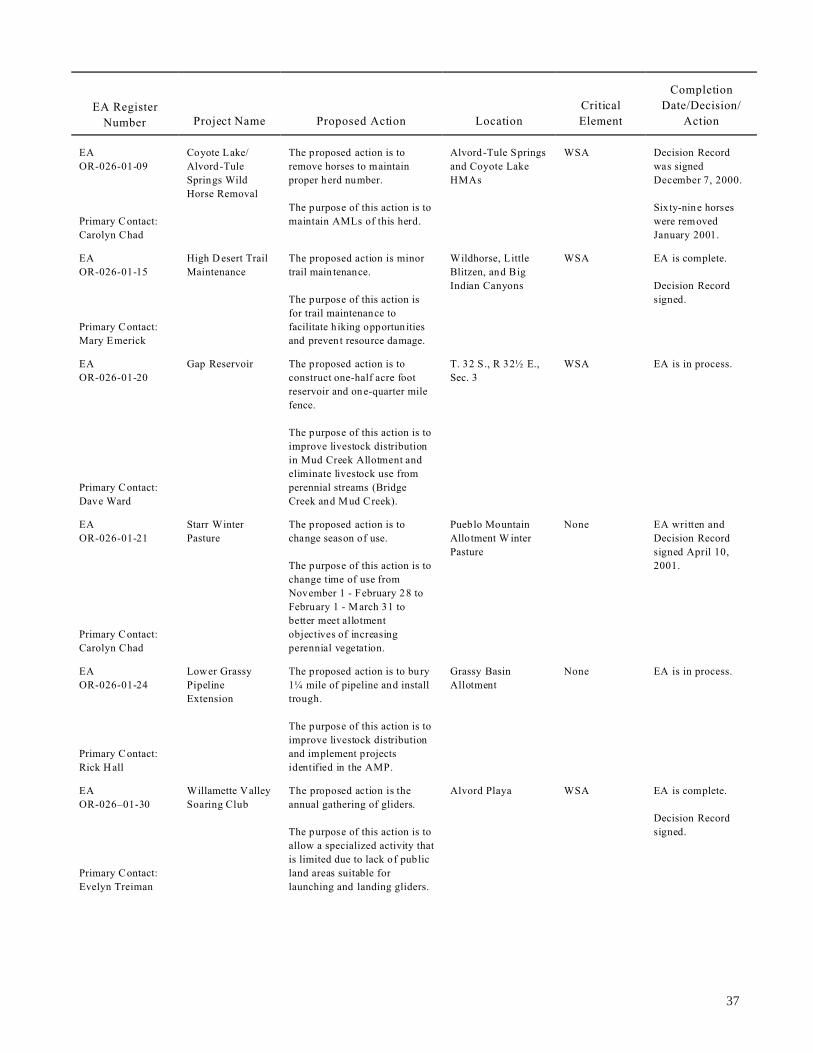
EA
EA
EA
EA
EA
Rick Hall
EA
EA Register
Number Project Name Proposed Action Location
Critical
Element
Completion
Date/Decision/
Action
Coyote Lake/
Alvord-Tule OR-026-01-09
The proposed action is to
remove horses to maintain
Alvord-Tule Springs
and Coyote Lake
WSA Decision Record
was signed
Springs Wild
Horse Removal
proper herd number. HMAs December 7, 2000.
mary Contact: Pri
The purpose of this action is to
maintain AMLs of this herd.
Sixty-nine horses
were removed
January 2001.
High D esert Trail
Maintenance
rolyn Chad
OR-026-01-15
Ca
The proposed action is minor
trail main tenance.
Wildhorse, Little
Blitzen, and Big
WSA EA is complete.
Decision Record
The purpose of this action is
for trail maintenance to
Indian Canyons
signed.
Mary Emerick
mary Contact: Pri facilitate h iking opportun ities
and prevent resource damage.
Gap Reservoir
OR-026-01-20
The proposed action is to
construct one-half acre foot
T. 32 S., R 32½ E.,
Sec. 3
WSA EA is in process.
reservoir and one-quarter mile
fence.
The purpose of this action is to
improve livestock distribution
in Mud Creek Allotment and
eliminate livestock use from
Dave Ward
mary Contact: Pri perennial streams (Bridge
Creek and Mud Creek).
Starr Winter
PastureOR-026-01-21
The proposed action is to
change season of use.
Pueblo Mountain
Allotment W inter
Pasture
None EA written and
Decision Record
signed April 10,
The purpose of this action is to
change time of use from
November 1 - February 28 to
February 1 - March 31 to
better meet allotment
2001.
mary Contact: Pri
Carolyn Chad
objectives of increasing
perennial vegetation.
Lower Grassy
Pipeline
Extension
OR-026-01-24
The proposed action is to bury
1¼ mile of pipeline and install
trough.
Grassy Basin
Allotment
None EA is in process.
mary Contact: Pri
The purpose of this action is to
improve livestock distribution
and implement projects
identified in the AMP.
Willamette Valley
Soaring Club OR-026–01-30
The proposed action is the
annual gathering of gliders.
Alvord Playa WSA EA is complete.
Decision Record
mary Contact: Pri
The purpose of this action is to
allow a specialized activity that
is limited due to lack of public
land areas suitable for
signed.
elyn Treiman Ev launching and landing gliders.
37
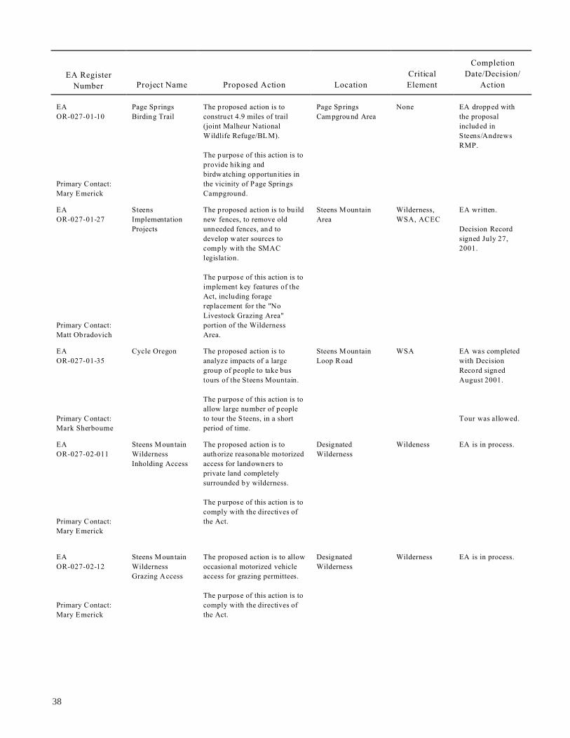
EA
EA
EA
EA
EA
Mary Emerick
EA Register
Number Project Name Proposed Action Location
Critical
Element
Completion
Date/Decision/
Action
Page Springs The proposed action is to Page Springs None EA dropped with
Birding Trail construct 4.9 miles of trail OR-027-01-10 Campground Area the proposal
(joint Malheur National included in
Wildlife Refuge/BL M). Steens/Andrews
RMP.
The purpose of this action is to
provide hiking and
birdwatching opportun ities in
the vicinity of Page Springs mary Contact: Pri
Mary Emerick Campground.
Steens The proposed action is to bu ild Steens Mountain Wilderness, EA written.
Implementation new fences, to remove old OR-027-01-27 Area WSA, ACEC
Projects unneeded fences, and to Decision Record
develop w ater sources to signed July 27,
comply with the SMAC 2001.
legislation.
The purpose of this action is to
implement key features of the
Act, including forage
replacement for the "No
Livestock Grazing Area"
portion of the Wildernessmary Contact: Pri
Matt Obradovich Area.
Cycle Oregon The proposed action is to Steens Mountain WSA EA was completed
analyze impacts of a large OR-027-01-35 Loop Road with Decision
group of people to take bus Record signed
tours of the Steens Mountain. August 2001.
The purpose of this action is to
allow large number of people
to tour the Steens, in a short mary Contact: Pri Tour was allowed.
Mark Sherbourne period of time.
Steens Mountain The proposed action is to Designated Wildeness EA is in process.
Wilderness authorize reasonable motorized OR-027-02-011 Wilderness
Inholding Access access for landowners to
private land completely
surrounded by wilderness.
The purpose of this action is to
comply with the directives of
Mary Emerick
the Act.mary Contact: Pri
Steens Mountain The proposed action is to allow Designated Wilderness EA is in process.
Wilderness occasional motorized vehicle OR-027-02-12 Wilderness
Grazing Access access for grazing permittees.
The purpose of this action is to
comply with the directives of mary Contact: Pri
the Act.
38

39
Inside Back Cover

UN
ITE
D S
TA
TE
SD
EP
AR
TM
EN
T O
F T
HE
INT
ER
IOR
BU
RE
AU
OF
LA
ND
MA
NA
GE
ME
NT
Burns D
istrict Office
28910 Hw
y 20 West
Hines, O
regon 97738
OF
FIC
IAL B
US
INE
SS
PE
NA
LTY
FO
R P
RIV
AT
E U
SE
, $300
PR
IOR
ITY
MA
ILP
OS
TA
GE
& F
EE
S P
AID
Bu
reau o
f Lan
d M
anag
emen
tP
ermit N
o. G
-76