FUTURE WALES THE NATIONAL PLAN 2040 · 2021. 2. 23. · Policy P22 and the housing need. 07...
125
FUTURE WALES – THE NATIONAL PLAN 2040 Habitats Regulations Assessment FEBRUARY 2021
Transcript of FUTURE WALES THE NATIONAL PLAN 2040 · 2021. 2. 23. · Policy P22 and the housing need. 07...

FUTURE WALES – THE NATIONAL PLAN 2040
Habitats Regulations Assessment
FEBRUARY 2021

Copyright © 2018 Arcadis. All rights reserved. arcadis.com
CONTACT
MARTINA GIRVAN
TECHNICAL DIRECTOR - HEAD OF
ECOLOGY
Arcadis.
ECHQ, 34 York Way
London N1 9AB United Kingdom.

Copyright © 2018 Arcadis. All rights reserved. arcadis.com
Our first national development framework will when published be called ‘Future
Wales – The National Plan 2040’. This assessment was prepared prior to
publication and uses the name ‘national development framework’ and ‘NDF’
throughout. For clarification the references to the national development framework
in this document are taken to mean Future Wales – The National Plan 2040.
From 1st January 2021 in Wales Natura 2000 sites will be known as ‘National Site Network sites’. This assessment has been in preparation since 2016 and uses the terms Natura 2000 sites throughout reflecting the correct terminology at the time. For clarification the references to Natura 2000 sites in this document are taken to
mean National Site Network sites.

VERSION CONTROL
Version Date Author Checker Approver Changes
01 21/5/19 JW LT JD First Draft
02 3/6/19 JW/LT/JD LT JD Second Draft following comments
from WG and revisions to Draft NDF
03 1/7/19 LT/JD LT JD Third Draft following final comments
from WG
04 March
2020 LT DH MG
Based on Draft NDF including
proposed changes
05 June
2020 LT/MG JE/ST MG Based on amendments to P10
06 August
2020 JE JE MG
Review in light of amendments to
Policy P22 and the housing need.
07 November
2020 JE JE MG
Amendment to correct the buffer
zone applied to Elenydd-Mallaen
SPA
08 January
2021 LT ST/ MG MG
Amendments following Senedd
Scrutiny
This report dated February 2021 has been prepared for the Welsh Government (the “Client”) in accordance with the
terms and conditions of appointment (the “Appointment”) between the Client and Arcadis UK (“Arcadis”) for the
purposes specified in the Appointment. For avoidance of doubt, no other person(s) may use or rely upon this report or its
contents, and Arcadis accepts no responsibility for any such use or reliance thereon by any other third party.

Future Wales – The National Plan 2040 - HRA
1
CONTENTS
GLOSSARY ......................................................................................................................... 2
ACRONYMS ........................................................................................................................ 4
EXECUTIVE SUMMARY ..................................................................................................... 6
1 INTRODUCTION ....................................................................................................... 8
1.1 Purpose .................................................................................................................................................. 8
1.2 The Habitats Regulations Assessment Process ............................................................................... 8
1.3 The National Development Framework Process ............................................................................... 9
1.4 Approach to HRA of the NDF............................................................................................................. 10
1.5 Assessing impacts on Natura 2000/ Ramsar sites .......................................................................... 13
2 SCREENING ............................................................................................................ 17
2.1 Screening Approach ........................................................................................................................... 17
2.2 Screening Assessment ...................................................................................................................... 17
2.3 Screening Conclusion ........................................................................................................................ 32
3 IN-COMBINATION EFFECTS ................................................................................. 33
4 APPROPRIATE ASSESSMENT ............................................................................. 34
4.1 Appropriate Assessment Approach ................................................................................................. 34
4.2 Avoidance / Mitigation Measures ...................................................................................................... 34
4.3 Appropriate Assessment Table ......................................................................................................... 37
4.4 Appropriate Assessment Conclusion (alone).................................................................................. 79
5 IN-COMBINATION EFFECTS ................................................................................. 80
5.1 Appropriate Assessment In-combination Conclusion ................................................................... 83
6 OVERALL CONCLUSION ....................................................................................... 84
7 REFERENCES ........................................................................................................ 85
Appendix A: Appropriate Assessment Avoidance/Mitigation Measures Summary Table
Appendix B: Pre-Assessed Wind Areas
Future Wales – The National Plan 2040 - HRA
2
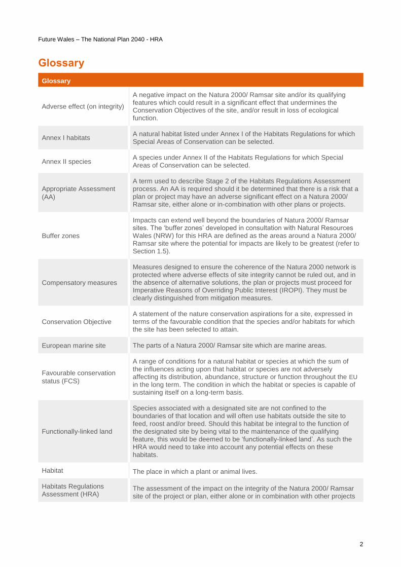
Glossary
Glossary
Adverse effect (on integrity)
A negative impact on the Natura 2000/ Ramsar site and/or its qualifying features which could result in a significant effect that undermines the Conservation Objectives of the site, and/or result in loss of ecological function.
Annex I habitats A natural habitat listed under Annex I of the Habitats Regulations for which Special Areas of Conservation can be selected.
Annex II species A species under Annex II of the Habitats Regulations for which Special Areas of Conservation can be selected.
Appropriate Assessment
(AA)
A term used to describe Stage 2 of the Habitats Regulations Assessment process. An AA is required should it be determined that there is a risk that a plan or project may have an adverse significant effect on a Natura 2000/ Ramsar site, either alone or in-combination with other plans or projects.
Buffer zones
Impacts can extend well beyond the boundaries of Natura 2000/ Ramsar sites. The ‘buffer zones’ developed in consultation with Natural Resources Wales (NRW) for this HRA are defined as the areas around a Natura 2000/ Ramsar site where the potential for impacts are likely to be greatest (refer to Section 1.5).
Compensatory measures
Measures designed to ensure the coherence of the Natura 2000 network is protected where adverse effects of site integrity cannot be ruled out, and in the absence of alternative solutions, the plan or projects must proceed for Imperative Reasons of Overriding Public Interest (IROPI). They must be clearly distinguished from mitigation measures.
Conservation Objective
A statement of the nature conservation aspirations for a site, expressed in terms of the favourable condition that the species and/or habitats for which the site has been selected to attain.
European marine site The parts of a Natura 2000/ Ramsar site which are marine areas.
Favourable conservation
status (FCS)
A range of conditions for a natural habitat or species at which the sum of the influences acting upon that habitat or species are not adversely affecting its distribution, abundance, structure or function throughout the EU in the long term. The condition in which the habitat or species is capable of sustaining itself on a long-term basis.
Functionally-linked land
Species associated with a designated site are not confined to the boundaries of that location and will often use habitats outside the site to feed, roost and/or breed. Should this habitat be integral to the function of the designated site by being vital to the maintenance of the qualifying feature, this would be deemed to be ‘functionally-linked land’. As such the HRA would need to take into account any potential effects on these habitats.
Habitat The place in which a plant or animal lives.
Habitats Regulations Assessment (HRA)
The assessment of the impact on the integrity of the Natura 2000/ Ramsar site of the project or plan, either alone or in combination with other projects

Future Wales – The National Plan 2040 - HRA
3
Glossary
or plans, with respect to the site’s structure and function and its conservation objectives.
Imperative Reasons of Overriding Public Interest
A part of the derogations tests in Article 6(4) of the Habitats Regulations 62 and 103 of the Habitats Regulations and Part 4 of stage 4 of the Habitats Regulations Assessment a situation which would allow plans or projects to take place that many adversely affect the integrity of a Natura 2000/ Ramsar site.
Likely Significant Effect (LSE)
A likely effect is one that cannot be ruled out on the basis of objective information. The test is a likelihood of and an effect, rather than the certainty of that effect occurring. i.e. there is a risk, or possibility of an effect being significant.
Mitigation measures After avoidance, mitigation is an action or actions that may be applied to reduce or cancel the adverse effects of a plan or project on a Natura 2000/ Ramsar site.
Natura 2000 site The European network of protected sites established under the Habitats and Birds Directives.
Pre-Assessed Areas Areas identified by the Welsh Government as potential locations for future
wind energy development (refer to Policy 17).
Qualifying features (of a site)
The habitats or species for which a site has been classified SPA or designated SAC or listed as a Ramsar site.
Ramsar site Site designated under the 1971 Ramsar Convention as a wetland of international importance.
Special Area of Conservation (SAC)
Site designated under the Habitats Regulations for their habitats and/or species of European importance (includes Primary Reasons/Qualifying Features - Annex I Habitats/Annex II Species).
Screening A term used to describe Stage 1 of the Habitats Regulations Assessment process and identifies the potential for LSE on Natural 2000/ Ramsar sites.
Special Protection Area (SPA)
Site designated under the Conservation of Wild Birds Directive for rare, vulnerable and regularly occurring migratory bird species and internationally important wetlands (includes Article 4.1/4.2 birds).
Site of Special Scientific Interest (SSSI)
A national (UK) designation for sites considered as being of special interest due to fauna, flora, geological or physiographical features.
The titles of the sites within this document reflect the JNCC lists and if a site has a bilingual title, only the English version is used in this report.
JNCC Lists –
SACs: https://sac.jncc.gov.uk/site/wales
SPAs: https://jncc.gov.uk/our-work/list-of-spas/
Ramsar sites: https://jncc.gov.uk/our-work/ramsar-sites/

Future Wales – The National Plan 2040 - HRA
4
Acronyms
Acronyms
AA Appropriate Assessment
AONB Area of Outstanding Natural Beauty
CAP Common Agricultural Policy
CEMP Construction Environmental Management Plan
DCO Development Consent Order
DNS Developments of National Significance
EU European Union
FCERM Flood and Coastal Erosion Risk Management
FCS Favourable conservation status
FRMP Flood Risk Management Plan
GIS Geographical Information System
HRA Habitats Regulations Assessment
HRO Harbour Revisions Order
IROPI Imperative Reasons of Overriding Public Interest
LDP Local Development Plan
LSE Likely Significant Effect
NDF National Development Framework
NFM Natural Flood Management
NHCP National Habitat Creation Programme
NPPF National Planning Policy Framework
NRP Natural Resources Policy
NRW Natural Resources Wales
PA Priority Area
PAA Pre-Assessed Areas
PPW Planning Policy Wales
RBMP River Basin Management Plans
RMA Risk Management Authority

Future Wales – The National Plan 2040 - HRA
5
Acronyms
RSZ Roost Sustenance Zone
SAC Special Area of Conservation
SDP Strategic Development Plan
SMP Shoreline Management Plan
SPA Special Protection Area
SSSI Site of Special Scientific Interest
SuDS Sustainable Drainage Systems
TAN Technical Advice Note
WFGA Well-being of Future Generations Act, 2015
WIIP Wales Infrastructure Investment Plan
WNMP Welsh National Marine Plan

Future Wales – The National Plan 2040 - HRA
6
Executive Summary
This Report provides the Habitats Regulations Assessment (HRA) Screening and Appropriate Assessment
(AA) of the Welsh Government’s National Development Framework (NDF). This Report summarises how the
NDF has evolved from the Issues and Options stage through to the current Future Wales – The National Plan
2040 document, along with the HRA work undertaken at each stage of the process. Note that this assessment
was prepared prior to publication and uses the name ‘national development framework’ and ‘NDF’ throughout.
For clarification the references to the national development framework in this document are taken to mean
Future Wales – The National Plan 2040.
The Conservation of Habitats and Species Regulations 2017 stipulate that a HRA must be carried out on all
Plans and Projects that have the potential to impact upon sites designated for supporting habitats or species
of international importance, otherwise known as Natura 2000 or European designated sites. In the United
Kingdom (UK), the requirements of the Habitats Regulations are also extended to consider the effects on
Ramsar sites (listed under the Ramsar Convention on Wetlands of International Importance). The presence of
Natura 2000/Ramsar sites within Wales, and the potential impacts that could arise as a result of
implementation of the NDF, requires that assessment under the Habitats Regulations is carried out.
Screening
The screening stage has provided a high-level assessment to determine whether the NDF could possibly lead
to Likely Significant Effects (LSE) on Natura 2000/ Ramsar sites. The purpose of this was to eliminate those
elements of the NDF from the assessment which very clearly would not affect designated sites in order to
focus on those policies where there was potential for effects or uncertainty about potential effects. Chapters 1
and 2 of the NDF have been screened out as they contain introductory text and contextual information which
would not lead to any effects on Natura 2000/ Ramsar sites. Chapter 3 comprises the Outcomes of the NDF.
Although all of the outcomes have the potential to lead to change, as the policies are the mechanism through
which the outcomes will be achieved, assessment of the policies themselves (which contain more detailed
information) was more appropriate. Chapter 3 has therefore also been screened out of further assessment. Of
the 36 policies set out within Chapters 4 and 5 of the NDF, 12 have been screened out from further Appropriate
Assessment since they either would not lead directly to change, or if they did, any change would be of such
small scale that no LSE on Natura 2000/ Ramsar sites could occur either alone or in-combination. The
remaining 24 policies were considered to have the potential to direct future development such that there could
be implications for Natura 2000/ Ramsar sites. These polices were therefore screened in for further Appropriate
Assessment alone and in-combination.
Appropriate Assessment
For projects, full details of the proposals are required to determine the mitigation measures required before a
meaningful conclusion can be drawn as to whether a project will have no LSE, or no adverse effect on integrity.
This is not possible for plans, especially high-level plans such as the NDF, which by definition are strategic in
nature. High-tier strategic plans set the overall policy framework which lower-tier plans and projects must
adhere to. In most cases the specific details of development provided for within a plan will not be available
until a later date, after it has been adopted. In the case of the NDF, this will be through Strategic Development
Plans, Local Development Plans and other strategic planning documents and projects which come forward
during the plan period. For the NDF, there are a number of policies with a spatial element, for these, the Natura
2000/Ramsar sites that could be affected as a result of the policy are identified (where possible) with examples
of the types of impacts that could occur. Since no specific development allocations or proposals are identified
in the NDF, it is not possible at this high level to identify all impacts associated with policy implementation;
however, the Appropriate Assessment process has determined the types of impacts which are most likely to
be encountered and identified measures for each of the polices which would avoid/ mitigate for such types of
impacts. These measures must be adhered to by Local Planning Authorities, Corporate Joint Committees and
developers when implementing the policies to ensure that there would be no adverse effects on the integrity
of Natura 2000/ Ramsar sites. The Appropriate Assessment concluded that none of the policies in the NDF
were considered to be actively directing development in such a location or manner that potential impacts
arising from projects emerging under the policies (or lower-tier plans which will identify development
opportunities for allocation) could not be avoided or mitigated at the lower-tier plan or project level. Where this
is not concluded lower-tier plans or projects cannot be approved (unless there are no less damaging alternative
solutions, Imperative Reasons of Overriding Public Interest (IROPI) and appropriate compensatory measures

Future Wales – The National Plan 2040 - HRA
7
have been secured). Future Wales does not support lower-tier plans or projects where adverse effects on site
integrity cannot be ruled out.
In-combination effects
The in-combination assessment at this high level is necessarily limited, and therefore in-combination effects
cannot be completely ruled out. However, given that all plans and projects with the potential to impact Natura
2000/ Ramsar sites are required to comply with the Conservation of Habitats and Species Regulations (2017),
Planning Policy Wales (PPW) 10 and Technical Advice Note (TAN) 5: Nature Conservation and Planning as a
matter of law, any potential in-combination effects would be identified and appropriate mitigation developed at
subsequent lower-tier stages of the implementation of the NDF. Compliance with PPW10, TAN5 and the
avoidance/mitigation measures set out against each of the policies within the NDF will ensure no adverse in-
combination effects on Natura 2000/ Ramsar sites. The Welsh Government would not support any lower-tier
plans or projects, associated with policies within the NDF, where adverse in-combination effects on Natura
2000/ Ramsar sites cannot be avoided through mitigation. The in-combination assessment therefore
concludes that (assuming the avoidance/ mitigation measures set out within this HRA are implemented), there
would be no adverse in-combination impacts on the integrity of any Natura 2000/ Ramsar sites as a result of
implementation of the policies set out with the NDF.
Overall Conclusion
Whilst this HRA has made it clear that it is difficult at this very strategic stage of the development planning
process in Wales to be clear about how Natura 2000/ Ramsar sites may or may not be affected by strategic
policy decisions, it is important to note that the potential implications for Natura 2000/ Ramsar sites have been
considered throughout the development of the Plan, such that early avoidance of the issues (and/or reduction
of risk) has been a key element of the process when compiling the policies within the NDF. It is important to
note the legal requirement for lower-tier plans and projects with the potential to impact Natura 2000/ Ramsar
sites (through the Habitats Regulations (2017), PPW10 and TAN5) to undertake HRA. Table 7 of the
Appropriate Assessment sets out the types of impacts which could occur through implementation of the policies
and identifies avoidance/mitigation measures which must be adhered to when producing lower-tier plans and
projects. The NDF does not support lower-tier plans or projects where adverse effects on site integrity cannot
be ruled out. Development at the lower-tier plan or project stage will need to demonstrate there are no adverse
effects on the features for which a Natura 2000/Ramsar site has been designated and where this is not
concluded lower-tier plans or projects cannot be approved (unless there are no less damaging alternative
solutions, IROPI and appropriate compensatory measures have been secured).
This HRA Report provides sufficient safeguarding to be able to confirm that no adverse effects on integrity are
anticipated as a result of implementing the policies within the NDF (alone or in-combination).

Future Wales – The National Plan 2040 - HRA
8
1 Introduction
1.1 Purpose
This Report provides the Habitats Regulations Assessment (HRA) Screening and Appropriate Assessment
(AA) of the Welsh Government’s National Development Framework (NDF). This Report summarises how the
NDF has evolved from the Issues and Options stage through to the current Future Wales – The National Plan
2040 document , along with the HRA work undertaken at each stage of the process. Note that this assessment
was prepared prior to publication and uses the name ‘national development framework’ and ‘NDF’ throughout.
For clarification the references to the national development framework in this document are taken to mean
Future Wales – The National Plan 2040.
This Report comprises the Screening of the policies set out in the NDF followed by the AA of those policies
where LSE on Natura 2000/ Ramsar sites could not be screened out.
1.2 The Habitats Regulations Assessment Process
The Conservation of Habitats and Species Regulations 2017 (as amended, hereafter referred to as the
‘Habitats Regulations’) stipulate that a HRA must be carried out on all Plans and Projects that have the potential
to impact upon sites designated for supporting habitats or species of international importance, otherwise known
as Natura 2000 or European designated sites. In the UK, the requirements of the Habitats Regulations are
also extended to consider the effects on Ramsar sites (listed under the Ramsar Convention on Wetlands of
International Importance). The presence of Natura 2000/Ramsar sites within Wales, and the potential impacts
that could arise as a result of implementation of the NDF, requires that assessment under the Habitats
Regulations is carried out.
In relation to Brexit, the Welsh Ministers have made changes to parts of the 2017 Habitats Regulations to
ensure that they can operate effectively from the 1st January 2021. Most of the changes have involved
transferring functions from the European Commission to the appropriate Welsh authorities. References to
Natura 2000 sites have been replaced with National Site Network sites, this assessment has been in
preparation since 2016 and uses the terms Natura 2000 sites throughout reflecting the correct terminology at
the time. For clarification the references to Natura 2000 sites in this document are taken to mean National Site
Network sites. All other processes or terms in the 2017 Habitats Regulations have remained unchanged and
existing guidance is still relevant. The obligations of a competent authority in the 2017 Habitats Regulations
for the protection of sites or species do not change as a result of implementing the Conservation of Habitats
and Species (Amendment) (EU Exit) Regulations 2019. For the purposes of this iteration of the HRA, the 2017
Regulations will be referred to as required (for further information refer to https://gov.wales/changes-habitats-
regulations-2017).
What is Habitats Regulations Assessment?
Under Article 6 of the Habitats Directive (Regulation 105 of the Habitats Regulations), an assessment is
required where a plan may give rise to LSEs upon a Natura 2000 site. Natura 2000 sites include Special Areas
of Conservation (SAC) (including ‘candidate’ SACs) and Special Protection Areas (SPA) (including ‘proposed’
SPAs). In the UK, it is a requirement for Ramsar sites to be included within the assessment:
SACs are designated under the Habitats Regulations for their habitats and/or species of European
importance (includes Primary Reasons/Qualifying Features - Annex I Habitats/Annex II Species).
SPAs are designated under the Conservation of Wild Birds Directive for rare, vulnerable and
regularly occurring migratory bird species and internationally important wetlands (includes Article
4.1/4.2 birds).
Ramsar sites are designated under the Ramsar Convention for their internationally important
wetlands (includes Criteria).

Future Wales – The National Plan 2040 - HRA
9
HRA can be defined as:
‘The consideration of the impact on the integrity of the Natura 2000 site of the project or plan, either
alone or in-combination with other projects or plans, with respect to the site’s structure and function
and its conservation objectives’
Where:
Integrity is ‘the coherence of its ecological structure and function, across its whole area, that
enables it to sustain the habitat, complex of habitats and/or the levels of populations of the species
for which it was classified’ – therefore this goes beyond minor effects;
Assessment of the implications for the site is made in view of its conservation objectives
(extent/condition of habitats, size/status of populations - set out in Core Management Plans,
Prioritised Improvement Plans, etc.);
An effect is significant if it would ‘undermine the conservation objectives’ of the site (Waddenzee
Judgement1) - this represents a proxy for an effect on the integrity of a site.
It is possible to consent a plan that would have significant effects, but under Article 6(4) (of the Habitats
Regulations), if you are likely to have an adverse effect on the integrity of a Natura 2000/ Ramsar site, then it
must adhere to the following (as per Managing Natura 2000 sites - The provisions of Article 6 of the 'Habitats'
Directive 92/43/EEC - November 2018):
the alternative put forward for approval is the least damaging for the integrity of the Natura 2000
site(s) …. and that no other feasible alternative exists that would not adversely affect the integrity
of the site(s);
there are imperative reasons of overriding public interest; and
all compensatory measures necessary to ensure that the overall coherence of Natura 2000 is
protected are taken.
Being an exception to Article 6(3), this provision must be interpreted strictly, and can only be applied to
circumstances where all the conditions required by the Regulations, listed above, are fully satisfied.
Legislation and Guidance
This HRA is being made in accordance with the requirements of the Conservation of Habitats and Species
Regulations 2017, as amended. In doing so, this HRA Report has drawn upon the following guidance:
European Commission, Managing Natura 2000 sites: The provisions of Article 6 of the Habitats
Directive 92/43/EEC.
European Commission, Guidance document on Article 6(4) of the Habitats Directive 92/43/EEC.
Department for Communities and Local Government (2006) Planning for the Protection of
European Sites: Appropriate Assessment. Guidance for Regional Spatial Strategies and Local
Development Documents.
David Tyldesley and Associates (DTA) Publications Limited, The Habitats Regulations
Assessment Handbook.
People Over Wind and Sweetman v Coillte Teoranta – European Court of Justice, Case C323/17.
1.3 The National Development Framework Process
The NDF has been developed over a 4-year period incorporating multiple consultation exercises with a range
of stakeholders from across the whole of Wales. The NDF is a spatial plan which sets a direction for where
investments in infrastructure and development should be focussed, such that they contribute to the broader
ambitions of the Welsh Government and to the well-being of communities. The aim of the NDF is to provide a
spatial context for the delivery of development and national planning policy in Wales over the next 20 years.
The NDF is therefore a fundamental part of the planning system in Wales. More information on the NDF and
the planning system is available on the Welsh Government website.
1 EC Case C-127/02 Reference for a Preliminary Ruling ‘Waddenzee’ September 2004

Future Wales – The National Plan 2040 - HRA
10
The first stage of the NDF was to collect evidence, engage and involve stakeholders and set out draft objectives
for future development in Wales, along with a series of spatial options. This culminated in the preparation of a
detailed consultation document. Five spatial options were identified, each with a different focus as to the future
direction of development plans, programmes and strategies within Wales. A Rules of Thumb document
(Appended to the HRA Report for the Draft NDF, July 2019) was produced by Arcadis to provide advice to the
Welsh Government with regards to the requirements of the HRA and how this should influence initial drafting
of the NDF. (This document can be viewed at: https://gov.wales/draft-national-development-framework).
The five spatial options were:
Community Focus.
Market Driven Focus.
Decarbonisation Focus.
Natural Resource Resilience Focus.
Do Not Prepare the NDF.
The NDF Preferred Option then set out how the land-use planning system would support the long-term aims
of the Well-being of Future Generations Act, 2015 (WFGA, 2015) as well as other government policies. The
NDF Preferred Option had two key roles: to provide spatial direction for growth and new infrastructure and
identify areas of change, protection, enhancement and mitigation; and to establish the direction for strategic
spatial policy. It was developed around five themes:
Placemaking;
Distinctive and Natural Places;
Productive and Enterprising Places;
Active and Social Places; and
Wales’s Regions.
The draft NDF comprised 33 policies covering a range of topics which set the direction for development in
Wales from 2020 to 2040. HRA Screening and Appropriate Assessment were carried out on this document
and the draft NDF and associated HRA documents (July 2019) were subsequently put out to public
consultation in Autumn 2019. (This document can be viewed at: https://gov.wales/draft-national-development-
framework).
The Welsh Government received 1,088 responses to the public consultation process, all of which have been
read, analysed and considered. The consultation response report [https://gov.wales/draft-national-
development-framework] sets out further details on this. The public consultation highlighted a number of areas
(such as the renewable energy policies) where revisions to the NDF would be required. The NDF was
subsequently updated and the current document, comprising 36 policies, was produced in August 2020. The
HRA Report was updated in November 2020 to take account of the consultation responses as well as changes
to the NDF itself. .
The NDF was laid in the Senedd for a 60-day scrutiny period from 21st September to 26th November 2020,
during which a number of resolutions and recommendations were made by the Senedd. This report comprises
the HRA of the NDF including the changes made post Senedd scrutiny.
1.4 Approach to HRA of the NDF
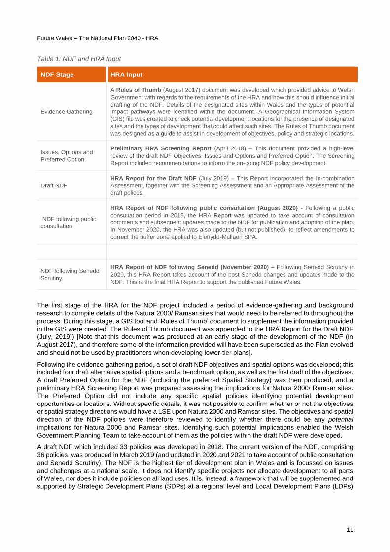
Table 1 summarises the stages of the NDF and corresponding HRA inputs that have been provided.
Future Wales – The National Plan 2040 - HRA
11
Table 1: NDF and HRA Input
NDF Stage HRA Input
Evidence Gathering
A Rules of Thumb (August 2017) document was developed which provided advice to Welsh
Government with regards to the requirements of the HRA and how this should influence initial
drafting of the NDF. Details of the designated sites within Wales and the types of potential
impact pathways were identified within the document. A Geographical Information System
(GIS) file was created to check potential development locations for the presence of designated
sites and the types of development that could affect such sites. The Rules of Thumb document
was designed as a guide to assist in development of objectives, policy and strategic locations.
Issues, Options and
Preferred Option
Preliminary HRA Screening Report (April 2018) – This document provided a high-level
review of the draft NDF Objectives, Issues and Options and Preferred Option. The Screening
Report included recommendations to inform the on-going NDF policy development.
Draft NDF
HRA Report for the Draft NDF (July 2019) – This Report incorporated the In-combination
Assessment, together with the Screening Assessment and an Appropriate Assessment of the
draft polices.
NDF following public
consultation
HRA Report of NDF following public consultation (August 2020) - Following a public
consultation period in 2019, the HRA Report was updated to take account of consultation
comments and subsequent updates made to the NDF for publication and adoption of the plan.
In November 2020, the HRA was also updated (but not published), to reflect amendments to
correct the buffer zone applied to Elenydd-Mallaen SPA.
NDF following Senedd
Scrutiny
HRA Report of NDF following Senedd (November 2020) – Following Senedd Scrutiny in
2020, this HRA Report takes account of the post Senedd changes and updates made to the
NDF. This is the final HRA Report to support the published Future Wales.
The first stage of the HRA for the NDF project included a period of evidence-gathering and background
research to compile details of the Natura 2000/ Ramsar sites that would need to be referred to throughout the
process. During this stage, a GIS tool and ‘Rules of Thumb’ document to supplement the information provided
in the GIS were created. The Rules of Thumb document was appended to the HRA Report for the Draft NDF
(July, 2019)) [Note that this document was produced at an early stage of the development of the NDF (in
August 2017), and therefore some of the information provided will have been superseded as the Plan evolved
and should not be used by practitioners when developing lower-tier plans].
Following the evidence-gathering period, a set of draft NDF objectives and spatial options was developed; this
included four draft alternative spatial options and a benchmark option, as well as the first draft of the objectives.
A draft Preferred Option for the NDF (including the preferred Spatial Strategy) was then produced, and a
preliminary HRA Screening Report was prepared assessing the implications for Natura 2000/ Ramsar sites.
The Preferred Option did not include any specific spatial policies identifying potential development
opportunities or locations. Without specific details, it was not possible to confirm whether or not the objectives
or spatial strategy directions would have a LSE upon Natura 2000 and Ramsar sites. The objectives and spatial
direction of the NDF policies were therefore reviewed to identify whether there could be any potential
implications for Natura 2000 and Ramsar sites. Identifying such potential implications enabled the Welsh
Government Planning Team to take account of them as the policies within the draft NDF were developed.
A draft NDF which included 33 policies was developed in 2018. The current version of the NDF, comprising
36 policies, was produced in March 2019 (and updated in 2020 and 2021 to take account of public consultation
and Senedd Scrutiny). The NDF is the highest tier of development plan in Wales and is focussed on issues
and challenges at a national scale. It does not identify specific projects nor allocate development to all parts
of Wales, nor does it include policies on all land uses. It is, instead, a framework that will be supplemented and
supported by Strategic Development Plans (SDPs) at a regional level and Local Development Plans (LDPs)

Future Wales – The National Plan 2040 - HRA
12
at local authority level. It is these ‘lower-tier’ plans which will provide more detail on specific locations and types
of infrastructure and development.
In accordance with the DTA guidance, in order to ascertain that there would be no adverse effect on the
integrity of a Natura 2000/ Ramsar site, a plan-making body may only rely on mitigation measures in a lower-
tier plan or project level if the following three criteria are all met:
• The higher-level plan assessment cannot reasonably predict any effect on a European site in a meaningful way; whereas
• The lower-tier plan or project level, which will identify more precisely the nature, timing, duration, scale or location of development, and thus its potential effects, will have the necessary flexibility over the exact nature, timing, duration, scale and location of the proposal to enable an adverse effect on site integrity to be avoided; and
• The HRA of the lower-tier plan or project is required as a matter of law or Government policy.
Given the nature of the NDF, it is therefore the lower-tier plans and projects which will include sufficient detail
to allow for a meaningful assessment of the potential impacts that such development could have on Natura
2000/Ramsar sites. The HRA at this level of the planning hierarchy is therefore necessarily high-level and
precautionary.
The Screening stage identifies those elements of the Plan that are considered could lead to development that
could have the potential for LSEs upon Natura 2000/Ramsar sites. The Rules of Thumb document helped to
focus the screening assessment onto those types of developments which could affect qualifying habitats and
species of Natura 2000/ Ramsar sites (see also 1.5, below, for a summary of this assessment process). The
‘screened in’ policies were then taken through to AA, which identified policy-specific impacts and associated
avoidance/ mitigation measures; this was aimed at flagging up the particular issues that would need addressing
in HRAs of lower-tier plans and projects.
As stated in the third bullet point above, all lower-tier plans and projects that have the potential to impact upon
Natura 2000/Ramsar sites (regardless of their proximity to these sites) are required to comply with the
Conservation of Habitats and Species Regulations (2017) as a matter of law. Therefore, irrespective of the
policy wording included within the NDF, statutory HRA of lower tier plans/ projects would be required. Planning
Policy Wales 10 (PPW) and Technical Advice Note (TAN) 5 also place a requirement on planners and
developers to undertake a HRA if potential impacts on Natura 2000/Ramsar sites have been identified. PPW
10 states that:
‘Statutory designation of a site does not necessarily prohibit development, but proposals must be carefully
assessed to ensure that effect on those nature conservation interests which the designation is intended to
protect are clearly understood; development should be refused where there are adverse impacts on the
features for which a site has been designated. International and national responsibilities and obligations for
conservation should be fully met, and, consistent with the objectives of the designation, statutorily designated
sites protected from damage and deterioration, with their important features conserved and enhanced by
appropriate management. Further information on Habitats Regulations Assessment is contained in TAN 5:
Nature Conservation and Planning.’
It is nevertheless important that this HRA of the higher-tier NDF identifies the types of potential impacts which
could arise from policy implementation, and how these could be avoided/mitigated at a later stage (i.e. ‘flagging
up’ potential issues at an early stage), as well as providing the high-level policy reassurance that future SDPs,
LDPs and developers will follow the necessary process to identify and assess potential implications for Natura
2000/Ramsar sites when allocating land for development. The subsequent LDP-level, or even project-level
HRAs will need to take into consideration the potential impacts identified in this HRA to guide their policy
development and ensure that mitigation measures can be delivered where potential for adverse effects are
identified. Cross-reference to this HRA and the proposed avoidance/ mitigation (set out in Section 4) is outlined
in Chapter 1 of the NDF (including a link to the avoidance/ mitigation section).
It is important to note that this is how the iterative HRA process ensures that plans and projects cannot be
consented or implemented without first ensuring that they would not have an adverse effect upon the integrity

Future Wales – The National Plan 2040 - HRA
13
of the European network of Natura 2000 and Ramsar sites. The next section describes how these potential
effects are assessed.
1.5 Assessing impacts on Natura 2000/ Ramsar sites
The assessment of the implications of the various policies set out in the NDF for the Natura 2000/Ramsar sites
is based upon a consideration not only of the qualifying habitats and species within each Natura 2000/Ramsar
site but also the distance beyond each site’s boundaries over which significant or adverse impacts could still,
potentially, be experienced. The types of potential impact pathways which could result from implementation of
the NDF policies are summarised as follows:
Land-take within a Natura 2000/ Ramsar site (i.e. direct habitat loss);
Habitat degradation within a Natura 2000/ Ramsar site (i.e. indirect habitat loss);
Effects as a result of deterioration of air quality;
Effects on water quality or quantity;
Risk of disturbance/ displacement to species that are qualifying features of a Natura 2000/ Ramsar site;
Risk of mortality (to mobile species); and Severance and fragmentation creating barriers to movement.
Given that a number of these impacts can extend well beyond the boundaries of Natura 2000/Ramsar sites,
‘buffer zones’ around each Natura 2000/Ramsar site have been developed. The buffer zones have been
agreed in consultation with Natural Resources Wales (NRW) and are defined as the areas around a Natura
2000/Ramsar site where the potential for impacts are likely to be greatest. It should be noted that the buffer
distances (set out below) have generally not been developed on the basis of a comprehensive analysis of the
literature (other than for chough) but are instead relatively standard distances adopted by the ecological
consultancy industry. We have adopted these distances on the basis of our own professional judgement and
adopting the precautionary principle. They will be quite precautionary with regard to certain types of NDF
development (e.g. wind farms, mobile telecommunications infrastructure, etc.) since although the potential
does still exist for birds from nearby SPAs/Ramsar sites to be displaced from feeding grounds by such
development, the impact is likely to be less than that associated with other types of development (such as wind
farms and the potential for collision with turbines) where significant adverse effects on populations are more
likely. Clearly, this detailed consideration of buffers is only possible where there is an obvious spatial element
to a policy (e.g. Policy 17), but the principles can nevertheless also be applied more generally when considering
the potential for policies to lead to impacts. An illustration of the application of buffers is provided in the
assessment of the renewable and low carbon energy policy (Policy 17), refer to Appendix B.
For the purposes of this HRA, the following buffer zones have been applied:
SACs and Ramsar sites are generally habitat-based, impacts (beyond the obvious direct land-take)
are primarily to do with hydrological effects on wetland habitat and potential effects of air quality
changes, such as nitrogen deposition. Although the latter can occur over greater distances, especially
where the habitat is particularly sensitive to nutrient enrichment, significant effects (e.g. such that
individual plants are adversely affected physiologically or that plant communities are altered by
increased competitiveness of the more robust species present) are extremely unlikely over greater
distances, owing to the dispersal of emissions in the air. The buffer zone for Ramsar sites and for
SACs where bats (and birds) are not a qualifying feature has therefore been set at 5km.
Whilst lesser horseshoe bats can fly distances greater than 10km to access foraging areas, the vast
majority of the feeding habitat necessary to resource a roost (i.e. the ‘roost sustenance zone (RSZ)’)
is much closer than this. Although bats can also fly large distances from summer roosts to hibernation
sites and between maternity roosts, the risks associated with exposure to any form of development
(e.g. wind farms, road schemes, etc.) are much lower given that these journeys tend to be taken less
frequently than nightly foraging routes in the RSZs. The buffer zone for SACs where lesser

Future Wales – The National Plan 2040 - HRA
14
horseshoe bats are a qualifying feature has therefore been set at 10km. The SACs which this
would be relevant to are as follows:
o Pembrokeshire Bat Sites and Bosherston Lake SAC o Glynllifon SAC o Meirionnydd Oakwoods and Bat Sites SAC o Gwydyr Forest Mines SAC o Wye Valley Woodlands SAC o Wye Valley and Forest of Dean Bat Sites SAC o Usk Bat Sites SAC o Tanat and Vyrnwy Bat Sites SAC
Following consultation with NRW in 2019, it was determined that a separate buffer zone for greater
horseshoe and barbastelle bats should be included. Whilst the 10 km buffer is suitable for lesser
horseshoe bats, it is considered insufficient to reduce risk to greater horseshoe and barbastelle bat
SAC populations given these species regularly travel significant distances (the RSZ for barbastelles
is at least 6 km). Many SAC bat populations are also critically supported by surrounding habitats and
a range of ‘annex’ roosts that are not contained within the designation. As knowledge of these areas
is deficient, and with due regard for greater horseshoe bat and barbastelle bat ecology, taking a
precautionary approach, the buffer zone for SACs where barbastelle and greater horseshoe bats
are a qualifying feature has been set at 20km. The SACs where this is relevant are as follows:
o Limestone Coast of South West Wales SAC (greater horseshoe bat) o Pembrokeshire Bat Sites and Bosherston Lake SAC (greater horseshoe bat) o North Pembrokeshire Woodlands SAC (barbastelle bat) o Wye Valley and Forest of Dean Bat Sites SAC (greater horseshoe bat)
Certain bird species associated with SPAs and Ramsar sites (e.g. raptors, wildfowl & waders etc.)
tend to readily fly greater distances as part of their foraging behaviour. Thus, birds associated with a
designated site are certainly not confined to the boundaries of that location and will often fly some
distance from it to feed, roost or breed. This is the basis of the concept of ‘functionally-linked land’ and
the fact that HRAs of SPAs/ Ramsar sites need to take into account the fact that birds from the
designated population will often spend time outside the boundaries of the designated area. A number
of water birds are migratory, and therefore fly much greater distances between their breeding and
over-wintering grounds. Whilst it is clearly not practical to account for these distances in establishing
buffer zones, it is nevertheless important to consider the potential implications of NDF-facilitated
development on Natura 2000/ Ramsar sites even if they are located some distance away (up to 20
km), given the potential for mobile qualifying species. This is because even if a proposal site is many
kilometres from a SPA/ Ramsar site boundary, it could still be located directly on the migration flight
path for a SPA/ Ramsar site species. That said, migration is often carried out at height, so the risks
are likely to be small (other than for airport expansion), but this potential impact will at least need to
be considered at screening. Whilst this is unlikely to be a significant issue for certain types of
development being promoted by the NDF, such as solar farms (although the presence of such features
could displace birds from areas they would previously have used), there certainly is a risk of mortality,
disturbance and other impacts (e.g. associated with wind farms, roads, tourism, dog-walking from new
residential development etc.), even if they are some distance from the border of an Natura 2000/
Ramsar site supporting birds. The buffer zone for SPAs (and for Ramsar sites where the
qualifying features include bird species) has therefore been set at 20km.
A specific buffer zone has also been set for those SPAs where chough is a qualifying feature. Following
consultation with NRW in 2018, it was agreed that the particular status of this species in Wales (the
Welsh SPA network supports approximately 30% of the whole of the UK’s population), and the fact
that juvenile birds are known to disperse over particularly large distances, meant that a larger buffer
was required. Evidence suggests that 98% of males disperse up to 35km from the natal site, whilst
approximately 82% of females disperse up to 40km. The buffer zone for SPAs where the qualifying

Future Wales – The National Plan 2040 - HRA
15
features include chough has therefore been set at 40km. These SPAs where this would be relevant
are as follows:
o Castlemartin Coast (breeding and wintering), o Bird’s Rock (breeding and wintering), o Aberdaron Coast and Bardsey Island (breeding and wintering), o Holy Island Coast (breeding and wintering), o Mynydd Cilan, Trwyn y Wylfa ac Ynysoedd Sant Tudwal (breeding and wintering), o Ramsey and St David`s Peninsula Coast (breeding and wintering), o Skomer, Skokholm and the Seas off Pembrokeshire (breeding).
When considering potential impacts on designated habitats and species, consideration has also been given to
riverine habitats (and associated species), mobile species, ‘typical species’ and functionally linked land, as set
out below:
Riverine habitats (and associated species) – Whilst a buffer of 5km has been set for SAC habitats,
potential impacts (such as effects on water quality and mobilisation of sediment) on riverine SACs
could extend further than this (for example, into undesignated tributaries). Riverine SACs which
comprise mobile species, such as migratory fish (shad, lamprey, salmon, sea trout and eel) and otter
should also be considered beyond the 5km buffer. Where otters are a primary reason for site selection,
SACs only support a proportion of the habitat utilised by this species. Whilst it is recognised that SACs
encompass important areas of otter habitat, this species is wide-ranging and will use feeding and
breeding habitat outside of the SAC. Therefore, wherever a riverine SAC is downstream of a
proposed development, potential impacts should be assessed outside of the 5km buffer (i.e.
where potential developments are taking place upstream of riverine SACs, watercourses
throughout the catchment which includes the SAC must be considered).
Mobile species – includes those qualifying features (not already discussed above), which require
consideration beyond Natura 2000/ Ramsar site boundaries because they are migratory, or forage or
roost etc. ‘off-site’, or whose populations require movement and mixing across fragmented sites (at a
meta-population scale). For example, marsh fritillary butterflies are not confined to SACs and are
vulnerable to development (particularly in the Valleys and in Carmarthenshire in Wales). The key to
marsh fritillary conservation is the availability of more than 50ha of suitable habitat in good condition
within a well-connected landscape, which thereby supports functioning meta-populations. Therefore,
Natura 2000/ Ramsar sites whose qualifying features include mobile species, which may be
affected by policies within the NDF (irrespective of the location of the plan’s proposals or
whether the species would be in or out of the site when they might be affected), will be
considered in the assessment. Species (not already discussed above) which fall into this
category in Wales include:
o Marsh fritillary butterfly o Great crested newt o Sea mammals
Typical species – includes those that are not qualifying features of the Natura 2000/ Ramsar site in
their own right, but which are the typical species of a habitat which is a qualifying feature, and which
are often referred to in the Conservation Objectives. At the strategic level of the NDF HRA it is not
possible to consider them, but the potential need for them to be considered in future project-
level HRAs has been highlighted, refer to Section 4.
Functionally linked land - refers to the role or ‘function’ that land or sea beyond the boundary of a
Natura 2000/ Ramsar site might fulfil in terms of ecologically supporting the populations for which the
site was designated or classified (typically this includes waterbirds associated with SPAs as described
in relation to the buffer set for birds in bullet point 4 above, but is also applicable to other species such
as newts and bats). Such land is therefore ‘linked’ to the Natura 2000/ Ramsar site because it performs
an important role in maintaining or restoring the population of qualifying species at favourable
Future Wales – The National Plan 2040 - HRA
16
conservation status. Land which has been identified as functionally linked to a Natura 2000/ Ramsar
site holds the same level of protection as the Natura 2000/ Ramsar site itself, and therefore any
adverse effects on such land would need to be mitigated, as appropriate. Functionally linked land may
fall within buffers, but it may also lie outside. At the strategic level of the NDF HRA it is not possible
to identify specific areas of functionally linked land, but the potential need to consider it in
future project-level HRAs has been highlighted, where relevant, to ensure no adverse effects
on site integrity.
These buffer zones and consideration of mobile species, typical species and functionally linked land are very
important with regard to future consideration of development across Wales. Essentially, these should aid the
HRA Screening and Appropriate Assessment process for subsequent development proposals. This does not
mean that an Appropriate Assessment will automatically be required if a site lies within a buffer, but it does
mean that a HRA Screening Report will need to be prepared, setting out a detailed consideration of the impact
pathways between the proposed development and any Natura 2000/ Ramsar site qualifying habitats and/or
species, and thus the potential for LSE.

Future Wales – The National Plan 2040 - HRA
17
2 Screening
2.1 Screening Approach
The screening stage has provided a high-level assessment to determine whether the NDF could possibly lead
to LSEs on Natura 2000/ Ramsar sites. The purpose of this was to eliminate those elements of the NDF from
the assessment which very clearly would not affect designated sites in order to focus on those policies where
there was potential for effects or uncertainty about potential effects. When identifying the elements of the NDF
that could potentially affect Natura 2000/ Ramsar sites, it was important to focus upon those that would have
the greatest likelihood of impacting the sites. Note that the NDF is intended to be read as a single document
rather than a series of separate policies and has been assessed as such. Proposals in one area of the Plan
may mitigate potentially damaging activities promoted in another area and should be understood in the wider
context of the intended outcomes of the Plan.
2.2 Screening Assessment
The first two chapters of the NDF include introductory text and provide contextual information regarding the
development of the Plan. This part of the NDF is factual and does not in itself lead to change or development.
These sections cannot conceivably have any effects on Natura 2000/ Ramsar sites and are therefore screened
out of further assessment.
Table 2: Screening of Chapters 1 and 2
Section of the Plan Screening justification Screening conclusion
Chapter 1 – Introduction Introductory text Screened out
Chapter 2 - Wales: An Overview Contextual information Screened out
Chapter 3 Setting and Achieving Our Ambitions, includes the NDF Outcomes. A review of the NDF objectives
was undertaken at the Issues and Options stage in 2018. Following the iterative process of the plan
development, these objectives have since been updated and are now referred to as ‘Outcomes’. These
outcomes have been re-assessed below, refer to

Future Wales – The National Plan 2040 - HRA
18
Table 4. Chapters 4 and 5 set out the strategic policies within the NDF. These are the mechanism through
which the Outcomes will be achieved and are assessed in Table 5 below. [Note that how the policies link to
each of the Outcomes are listed in ‘The relationship between the NDF’s policies and the ‘Outcomes’ it sets out
to achieve’ Table on the last page of the NDF.] Policies taken through to Appropriate Assessment have been
highlighted in grey in Table 5.
The screening assessment follows guidance set out in Part F of the DTA HRA Guidance. Each of the outcomes
and policies within the NDF have been reviewed against the following list of screening categories (refer to
Table 3). These assessment categories have been specifically designed to identify the different types of policy
that could be implemented through high-level planning documents, and to determine whether future actions
arising from a policy could lead to development which could in turn affect Natura 2000/Ramsar sites.
Table 3: Screening Assessment Categories (Adapted from Section F.6.3 of the DTA HRA Handbook)
Category Description
Category A:
General statements of policy/general aspirations (screen out). Policies which are no more than
general statements of policy or general political aspirations should be screened out because they cannot have a significant effect on a site.
Category B:
Policies listing general criteria for testing the acceptability/sustainability of proposals (screen out). These general policies cannot have any effect on a European site and should be screened out.
Category C:
Proposal referred to but not proposed by the plan (screen out). Screen out any references to
specific proposals for projects, such as those which are identified, for example, in higher policy frameworks such as National Policy Statements, relating perhaps to nationally significant infrastructure projects. These will be assessed by the Secretary of State or Welsh Ministers.
Category D:
General plan-wide environmental protection/site safeguarding/ threshold policies (screen out).
These are policies, the obvious purpose of which is to protect the natural environment, including biodiversity, and/or to conserve or enhance the natural, built or historic environment, where enhancement measures will not be likely to have any adverse effect on a European Site. They can be screened out because the implementation of the policies is likely to protect rather than adversely affect European sites and would not undermine their conservation objectives.
Category E:
Policies or proposals that steer change in such a way as to protect European sites from adverse effects (screen out). These types of policies or proposals will have the effect of steering change away
from European sites whose qualifying features may be affected by the change, and they can therefore be screened out.
Category F:
Policies or proposals that cannot lead to development or other change (screen out). Policies that
do not themselves lead to development or other change, for example, because they relate to design or other qualitative criteria for development, such as materials for new development. They do not trigger any development or other changes that could affect a European site and can be screened out.
Category G:
Policies or proposals that could not have any conceivable adverse effect on a site (screen out).
Policies which make provision for change, but which could have no conceivable effect on a European site, because there is no causal connection or link between them and the qualifying features of any European site and can therefore be screened out.
Category H:
Policies or proposals the (actual or theoretical) effects of which cannot undermine the conservation objectives (either alone or in-combination with other aspects of this or other plans or projects) (screen out). Policies or proposals which make provision for change, but which could have
no significant effect on a European site, either alone or in combination with other aspects of the same plan, or in-combination with other plans or projects, and can therefore be screened out.
Category I:
Policies or proposals which may have a significant effect on a site alone (screen in). Policies or
proposals which are likely to have a significant effect on a European site alone should be screened in.

Future Wales – The National Plan 2040 - HRA
19
Category Description
Category J:
Policies or proposals unlikely to have a significant effect alone. These aspects of the plan would
have some effect on a site, but the effect would not be likely to be significant; so, they must be checked for in-combination (cumulative) effects. They will then be re-categorised as either Category K (no significant effect in-combination) or Category L (likely to have a significant effect in-combination).
Category K:
Policies or proposals unlikely to have a significant effect either alone or in-combination (screen out after the in-combination test). Those aspects of the plan with no potential for likely significant
effect alone or in-combination can be ruled out after the in-combination assessment.
Category L:
Policies or proposals which might be likely to have a significant effect in-combination (screen in after the in-combination test). Those aspects of the plan which would not have a significant effect
alone but has been identified as having the potential to impact on Natura 2000/ Ramsar sites in-combination with other plans or projects.
Category M:
Bespoke area, site or case specific policies or proposals intended to avoid or reduce harmful effects on European sites (screen in). Policies or proposals which have been included in the plan with
the intention of avoiding or reducing effects on specific European site(s) whose qualifying features may otherwise be affected by the plan being implemented.

Future Wales – The National Plan 2040 - HRA
20
Table 4: Screening Assessment of the NDF Outcomes
Outcomes Screening justification Screening Decision
A Wales where people live…..
1 – And work in connected, inclusive
and healthy places
This is a general policy statement and
would not lead to any effects on Natura
2000/ Ramsar sites.
Screened out (Category A)
2 - In vibrant rural places with
access to homes, jobs and services
This has the potential to lead to change,
however, the implications for Natura 2000/
Ramsar sites are more appropriately
addressed under the separate NDF
policies related to regeneration and
development.
Screened out (Category A)
3 - In distinctive regions that tackle
health and socio-economic
inequality through sustainable
growth
This has the potential to lead to change,
however, the implications for Natura 2000/
Ramsar sites are more appropriately
addressed under the separate NDF
policies related to regeneration and
development.
Screened out (Category A)
4 - In places with a thriving Welsh
Language
This is a general policy statement and
would not lead to any effects on Natura
2000/ Ramsar sites.
Screened out (Category A)
5 - And work in towns and cities
which are a focus and springboard
for sustainable growth
This has the potential to lead to change,
however, the implications for Natura 2000/
Ramsar sites are more appropriately
addressed under the separate NDF
policies related to regeneration and
development.
Screened out (Category A)
6 - In places where prosperity,
innovation and culture are promoted
This has the potential to lead to change,
however, the implications for Natura 2000/
Ramsar sites are more appropriately
addressed under the separate NDF
policies related to regeneration and
development.
Screened out (Category A)
7 - In places where travel is
sustainable
This has the potential to lead to change,
however, the implications for Natura 2000/
Ramsar sites are more appropriately
addressed under the separate NDF
policies related to transport and
infrastructure.
Screened out (Category A)
8 - In places with world-class digital
infrastructure
This has the potential to lead to change,
however, the implications for Natura 2000/
Ramsar sites are more appropriately
addressed under the separate NDF
policies for digital and mobile
communication.
Screened out (Category A)

Future Wales – The National Plan 2040 - HRA
21
Outcomes Screening justification Screening Decision
9 - In places that sustainably
manage their natural resources and
reduce pollution
This has the potential to lead to change,
however, the implications for Natura 2000/
Ramsar sites are more appropriately
addressed under the separate NDF
policies.
Screened out (Category A)
10 - In places with biodiverse,
resilient and connected ecosystems
This has the potential to lead to change,
however, the implications for Natura 2000/
Ramsar sites are more appropriately
addressed under the separate NDF
policies.
Screened out (Category A)
11 - In places which are
decarbonised and climate-resilient
This has the potential to lead to change,
however, the implications for Natura 2000/
Ramsar sites are more appropriately
addressed under the separate NDF
policies.
Screened out (Category A)

22
Table 5: Screening Assessment of the NDF Policies
Policy Screening justification Screening
Decision
Chapter 4: Strategic and Spatial Choices – The NDF Spatial Strategy
P1 – Where Wales will
grow
This policy sets out the Welsh Government’s support for sustainable growth in all parts of Wales. The policy will
support the direction for growth in employment and housing opportunities and investment in infrastructure within the
three National and Regional Growth Areas. This is an overarching policy and the implications for Natura 2000/
Ramsar sites are more appropriately addressed under the separate NDF polices for the National and Regional
Growth Areas.
Screened out
(Category A)
P2 – Shaping Urban
Growth and Regeneration
– Strategic Placemaking
This policy supports the growth and regeneration of towns and cities which positively contribute towards building
sustainable places that support active and healthy lives. It supports sustainable growth such as a rich mix of uses
and housing types, building places at a walkable scale, urban density development that can support public transport
and local facilities, and integrated green infrastructure, informed by the planning authority’s Green Infrastructure
Assessment. This is an overarching policy direction and implications for Natura 2000/ Ramsar sites are more
appropriately addressed under other policies within the NDF which provide greater spatial detail.
Screened out
(Category A)
P3 –Supporting Urban
Growth and Regeneration -
Public Sector Leadership
This policy states that the Welsh Government will play an active, enabling role to support the delivery of urban
growth and regeneration. The Welsh Government will work with local authorities and other public sector bodies to
unlock the potential of their land and support them to take an increased development role. Whilst new development
in Wales is likely to be focused around regenerating and developing existing urban town and city locations, there is
the potential for larger development/ infrastructure projects resulting from implementing this policy to impact Natura
2000/Ramsar sites, particularly those in coastal and more rural areas.
The potential implications for Natura 2000/ Ramsar sites as a result of this policy are provided in more detail in the
Appropriate Assessment.
Screened in
(Category I)
P4 - Supporting Rural
Communities
This policy outlines Welsh Governments support for sustainable and vibrant rural communities. It sets out the policy
direction for Strategic and Local Development Plans to assess the needs and set out policies that support their rural
communities. This is an overarching policy direction and implications for Natura 2000/ Ramsar sites are more
appropriately addressed under other policies within the NDF which provide greater spatial detail.
Screened out
(Category A)
P5 – Supporting the rural
economy
This policy supports sustainable, appropriate and proportionate economic growth in rural towns that is planned and
managed through Strategic and Local Development Plans. The policy sets out the need for Strategic and Local
Development Plans to plan positively to meet the employment needs of rural areas including employment arising
from the foundational economy; the agricultural and forestry sector, including proposals for diversification; start-ups
and micro businesses. The Welsh Government also strongly supports development of innovative and emerging
technology businesses and sectors, to help rural areas unlock their full potential. This is an overarching policy
Screened out
(Category A)

23
Policy Screening justification Screening
Decision
direction and implications for Natura 2000/ Ramsar sites are more appropriately addressed under other policies
within the NDF which provide greater spatial detail.
P6 – Town Centre First
This policy sets the location criteria for new commercial, retail, education, health, leisure and public service facilities.
The policy states that these facilities must be located within town or city centres with good access by public transport
from the whole town or city and, where appropriate, to the wider region. A sequential approach must be used to
inform the identification of the best location for significant new commercial, retail, education, health, leisure and
public service facilities. This policy provides guidance on locating services and the approach to be taken to assess
development plan allocations but implementing the policy itself would not lead to development and thus would have
no implications for Natura 2000/ Ramsar sites.
Screened out
(Category B)
P7 – Delivering Affordable
Homes
This policy confirms that the Welsh Government will increase delivery of affordable homes by ensuring that funding
for affordable homes is effectively allocated and utilised. The policy provides guidance for Strategic and Local
Development Plans in relation to affordable housing needs. Details of the locations for growth, are assessed under
other policies for each region, and as such, the implications for Natura 2000/ Ramsar sites are more appropriately
addressed under the separate policies for the National and Regional Growth Areas.
Screened out
(Category B)
P8 - Flooding
This policy outlines Welsh Government’s support for flood risk management that enables and supports sustainable
strategic growth and regeneration in National and Regional Growth Areas. The Welsh Government will work with
Flood Risk Management Authorities and developers to plan and invest in new and improved infrastructure,
promoting nature-based solutions as a priority. Whilst flood alleviation projects are likely to be located around
existing development, those projects in the vicinity of coastal areas, or alongside major rivers, could lead to potential
impacts on Natura 2000/Ramsar sites.
The Welsh Government is currently preparing a Draft National Strategy for Flood and Coastal Erosion Risk
Management in Wales (Welsh Government, 2019a) in order to implement the Flood and Water Management Act.
Policy 8 is based on the principles set out in the Strategy and would be implemented through the National Flood
Strategy (once adopted). The National Flood Strategy went out for consultation in Summer 2019 and is currently
being updated to reflect consultation comments. As part of the preparation of the Strategy a draft HRA Report was
produced (Welsh Government, 2019). Adverse effects could not be ruled out and the HRA therefore included an
assessment under Article 6(4) of the Habitats Regulations, comprising an alternative solutions assessment and
IROPI. The IROPI assessment then concluded that: ‘The failure to proceed with the Strategy would mean that there
would be no overall framework or co-ordination of the management of flood and coastal erosion risk in Wales, which
would ultimately result in both serious risk to infrastructure, human health and public safety, and unacceptable social
/ economic consequences. With the increasing risk from flooding and coastal erosion exacerbated as a result of
climate change, this risk will only increase over time. It is therefore considered that there are imperative reasons of
overriding public interest for the Strategy’. Compensation measures will therefore be required when projects come
forward as the Strategy is implemented; however, the draft HRA of the National Flood Strategy goes on to state that:
‘without information regarding the likely extent of any effects on integrity of individual European sites as a result of
activities arising from the Strategy, it is not possible to predict what compensatory measures might be appropriate in
National Strategy
for Flood and
Coastal Erosion
Risk Management
in Wales
Screened out
(Category C)
Projects not
associated with
the National
Strategy
Screened in
(Category I)

24
Policy Screening justification Screening
Decision
individual cases. Such measures will be expected to be identified at suitable locations at the project level, or
alternatively if the same conclusion is made following HRAs of the more spatially specific local Flood and Coastal
Erosion Risk Management (FCERM) strategies and projects. Compensatory measures are, in the majority of cases,
likely to be in the form of compensatory habitat to replace that which is considered likely to be lost from FCERM
activities arising from the strategy. The National Habitat Creation Programme (NHCP), managed by Natural
Resources Wales, but supported by other Risk Management Authorities (RMA’s), is delivering on a strategic basis,
the compensatory habitat necessary to compensate for any habitats lost as a result of FCERM plans, strategies and
projects.’ It should be noted that coastal schemes are likely to go through to the IROPI stage of assessment, due to
potential impacts associated with coastal squeeze. However, compensation measures will be delivered through a
Welsh Government fund (the National Habitat Creation Programme which is managed and delivered by NRW) to
ensure the appropriate provision of the compensatory habitat, as is necessary. As the Strategy has already gone
through the HRA process, no further assessment is required, and it can be screened out under Category C.
The Majority of flood defence works in Wales would be carried out under the National Strategy. Therefore, the only
projects screened into the Appropriate Assessment are those which fall outside of the National Strategy, including
private flood defence works. The potential implications for Natura 2000/ Ramsar sites as a result of these projects
are provided in more detail in the Appropriate Assessment.
P9 – Resilient Ecological
Networks and Green
Infrastructure
This policy sets criteria to ensure the enhancement of biodiversity, the resilience of ecosystems and the provision of
Green Infrastructure. The policy states that in all cases, action towards securing the maintenance and enhancement
of biodiversity (to provide a net benefit), the resilience of ecosystems and Green Infrastructure assets must be
demonstrated as part of development proposals through innovative, nature-based approaches to site planning and
the design of the built environment. Whilst this would be categorised as a policy for the protection of environmental
assets (Category D), if Green Infrastructure is developed in unsuitable locations, it may not necessarily be
compatible with the conservation objectives for Natura 2000/ Ramsar sites designated for the presence of other
habitat types or species. As such, the potential for unsuitable sites to be converted into Green Infrastructure is not
accounted for by the policy and potential impacts cannot be ruled out at this stage.
The potential implications for Natura 2000/ Ramsar sites as a result of developing new Green Infrastructure under
this policy are provided in more detail in the Appropriate Assessment.
Screened in
(Category I)
P10 – International
Connectivity
This policy identifies the Strategic Gateways in Wales including Cardiff Airport, Holyhead Port, Fishguard Port, and
Haven Waterway (including the Ports of Milford Haven and Pembroke Dock) and recognises the important roles they
play in international connectivity and regional economies.
The policy sets out support for the Strategic Gateways, in order that their international connectivity role can be
maintained, and also requires lower-tier plans to ensure that the benefits the Strategic Gateways provide to their
respective regions, and Wales, are maximised.
Screened in
(Category I)

25
Policy Screening justification Screening
Decision
The policy does not explicitly encourage new development at the Strategic Gateways nor an expansion of their
capacity. However, in order for their international connectivity role to be maintained, over the course of the NDF
period, there is the potential that new development, or an expansion in their capacity, may be required.
Any increase in the capacity of Holyhead, Haven Waterway, Fishguard and Cardiff Airport could potentially result in
impacts on Natura 2000/Ramsar sites around the Anglesey coast, Pembrokeshire coast, and the Severn Estuary.
Wider environmental effects (such as increased air pollution and the overall potential contribution to climate change)
should also be considered.
The potential implications for Natura 2000/ Ramsar sites as a result of this policy are provided in more detail in the
Appropriate Assessment.
P11 - National Connectivity
This policy sets out the Welsh Government’s support and investment in improving national connectivity. The Welsh
Government will work with Transport for Wales, local authorities, operators and partners to support the delivery of
improvements to the national cycle network, rail network, bus network and the strategic road network. Although the
majority of the improvement works are likely to take place within the existing cycle, rail and road network, there is the
potential for larger infrastructure projects to impact Natura 2000 sites/ Ramsar sites, especially those located in
coastal or more rural locations.
The potential implications for Natura 2000/ Ramsar sites as a result of this policy are provided in more detail in the
Appropriate Assessment.
Screened in
(Category I)
P12 – Regional
Connectivity
This policy outlines Welsh Governments support and investment in improving regional connectivity. The Welsh
Government will work with Transport for Wales, local authorities, operators and partners to support the delivery of
improvements to the bus and metro system as well as helping to implement the Active Travel Act and supporting
suitable fuelling infrastructure for ultra-low emission vehicles. Although the majority of the improvement works are
likely to take place within the existing networks, there is the potential for larger infrastructure projects to impact on
Natura 2000 sites/ Ramsar sites, especially those located in coastal or more rural locations.
The potential implications for Natura 2000/ Ramsar sites as a result of this policy are provided in more detail in the
Appropriate Assessment.
Screened in
(Category I)
P13 – Supporting Digital
Communications
This policy sets out the Welsh Government’s support for the provision of digital communications infrastructure and
services across Wales. Whilst it is considered likely that the majority of such digital communication infrastructure
would be small scale and within existing urban locations, the policy also recognises the need for improved mobile
telecommunications and broadband infrastructure in rural areas. Given the rural topography and physical distance of
some villages/ towns in Wales, there is the potential for the installation of larger more remote digital communication
infrastructure to impact on Natura 2000/Ramsar sites.
The potential implications for Natura 2000/ Ramsar sites as a result of this policy are provided in more detail in the
Appropriate Assessment.
Screened in
(Category I)

26
Policy Screening justification Screening
Decision
P14 – Planning in Mobile
Action Zones
This policy sets out a commitment to increase mobile coverage and will identify Mobile Action Zones across Wales,
showing locations where there is little or no mobile telecommunications coverage. Whilst it is considered likely that
the majority of such infrastructure would be small scale, and would fall under permitted development, given the rural
topography and physical distance of some villages/ towns in Wales, there is the potential for the installation of larger
more remote mobile communication infrastructure to impact on Natura 2000/Ramsar sites.
The potential implications for Natura 2000/ Ramsar sites as a result of this policy are provided in more detail in the
Appropriate Assessment.
Screened in
(Category I)
P15 – National Forest
This policy sets out Welsh Government’s commitment to developing a national forest for Wales. Whilst the policy is
providing for a positive environmental outcome (Category D), development of forest habitat may not necessarily be
compatible with the conservation objectives for Natura 2000/ Ramsar sites designated for the presence of other
habitat types or species not associated with forests. As such, the potential for unsuitable sites to be converted to
forest is not accounted for by the policy and potential impacts cannot be ruled out.
The potential implications for Natura 2000/ Ramsar sites as a result of this policy are provided in more detail in the
Appropriate Assessment.
Screened in
(Category I)
P16 – Heat Networks
This policy encourages planning authorities to identify opportunities for District Heat Networks and requires new and
existing development to integrate them, where appropriate. The policy sets the requirement for developers to
prepare an Energy Masterplan to establish whether a heat network is the most effective energy option. This policy
sets criteria but implementing the policy itself would not lead to development and therefore would have no
implications for Natura 2000/ Ramsar sites.
Screened out
(Category B)
P17 – Renewable and Low
Carbon Energy and
Associated Infrastructure
This policy sets out Welsh Government’s support, in principle, of developing renewable and low carbon energy, from
all technologies and at all scales, to meet our future energy needs. The policy refers to proposals for other large-
scale renewable energy generation which do not qualify as Developments of National Significance (DNS), refer to
Policy P18. Projects would need to demonstrate there would be no unacceptable adverse impacts upon nature
conservation sites and species as a result of such applications. Whilst this provides some assurance that
applications will be required to show that they have assessed the potential impacts upon designated sites, it cannot
be relied upon to conclude that there would be no LSEs upon Natura 2000/ Ramsar sites.
The potential implications for Natura 2000/ Ramsar sites as a result of this policy are provided in more detail in the
Appropriate Assessment.
Screened In
(Category I)
P18 - Renewable and Low
Carbon Energy
Developments of National
Significance
This policy sets out the criteria to be met by projects which qualify as DNSs. It puts a requirement on projects to
demonstrate that ‘ there are no adverse effects on the integrity of Internationally designated sites (including
European sites and Ramsar sites) and the features for which they have been designated (unless there are no
alternative solutions, Imperative Reasons of Overriding Public Interest (IROPI) and appropriate compensatory
measures have been secured) . This policy would not in itself lead to development, and the implications for Natura
Screened Out
(Category B)

27
Policy Screening justification Screening
Decision
2000/ Ramsar sites are more appropriately addressed under the separate NDF Policy 17 for Renewable and Low
Carbon Energy and Associated Infrastructure.
Chapter 5: The Regions
P19 – Strategic Policies for
Regional Planning
This policy provides an outline of the criteria to be embedded in Strategic Development Plans and constituent Local
Development Plans, where relevant. The policy includes the requirement for Strategic Development Plans to provide
a framework for the sustainable management of natural resources, as well as establishing ecological networks and
opportunities for protecting or enhancing the connectivity of these networks and the provision of Green
Infrastructure. This policy sets the criteria and direction for Strategic and Local Development Plans but implementing
the policy itself would not lead to development and therefore would have no implications for Natura 2000/ Ramsar
sites.
Screened out
(Category B)
The North
P20 – National Growth
Area - Wrexham and
Deeside
This policy sets out Welsh Government’s support for Wrexham and Deeside as the main focus for growth and
investment in the North region. The policy sets out the direction that Strategic and Local Development Plans should
take and must recognise the National Growth Area as the focus for strategic economic and housing growth;
essential services and facilities; advanced manufacturing and transport infrastructure. Although new development
and regeneration is likely to be focused around existing urban locations, there are a number of Natura 2000/ Ramsar
sites located close to Wrexham and Deeside, as well as around the coastline to the north of Deeside, and therefore
potential for LSE on these sites cannot be ruled out at this stage.
The potential implications for Natura 2000/ Ramsar sites as a result of this policy are provided in more detail in the
Appropriate Assessment.
Screened in
(Category I)
P21 – Regional Growth
Area - North Wales Coastal
Settlements
This policy sets out Welsh Government’s support for sustainable growth and regeneration in regionally important
towns along the northern Coast. Holyhead, Caernarfon, Bangor, Llandudno, Colwyn Bay, Rhyl and Prestatyn will be
a focus for managed growth and they have an important sub-regional role complementing the National Growth Area
of Wrexham and Deeside. The policy requires Strategic and Local Development Plans across the region to
recognise the roles of these coastal settlements as a focus for housing, employment, tourism, public transport and
key services. Although new development and regeneration is likely to be focused around existing urban locations,
there are a number of Natura 2000/ Ramsar sites around the north Wales coast, both on- and off-shore, which could
be affected by increased growth within the region and therefore LSE cannot be ruled out at this stage.
The potential implications for Natura 2000/ Ramsar sites as a result of this policy are provided in more detail in the
Appropriate Assessment.
Screened in
(Category I)
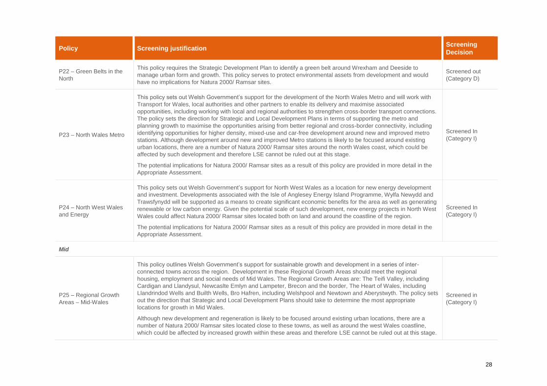
28
Policy Screening justification Screening
Decision
P22 – Green Belts in the
North
This policy requires the Strategic Development Plan to identify a green belt around Wrexham and Deeside to
manage urban form and growth. This policy serves to protect environmental assets from development and would
have no implications for Natura 2000/ Ramsar sites.
Screened out
(Category D)
P23 – North Wales Metro
This policy sets out Welsh Government’s support for the development of the North Wales Metro and will work with
Transport for Wales, local authorities and other partners to enable its delivery and maximise associated
opportunities, including working with local and regional authorities to strengthen cross-border transport connections.
The policy sets the direction for Strategic and Local Development Plans in terms of supporting the metro and
planning growth to maximise the opportunities arising from better regional and cross-border connectivity, including
identifying opportunities for higher density, mixed-use and car-free development around new and improved metro
stations. Although development around new and improved Metro stations is likely to be focused around existing
urban locations, there are a number of Natura 2000/ Ramsar sites around the north Wales coast, which could be
affected by such development and therefore LSE cannot be ruled out at this stage.
The potential implications for Natura 2000/ Ramsar sites as a result of this policy are provided in more detail in the
Appropriate Assessment.
Screened In
(Category I)
P24 – North West Wales
and Energy
This policy sets out Welsh Government’s support for North West Wales as a location for new energy development
and investment. Developments associated with the Isle of Anglesey Energy Island Programme, Wylfa Newydd and
Trawsfynydd will be supported as a means to create significant economic benefits for the area as well as generating
renewable or low carbon energy. Given the potential scale of such development, new energy projects in North West
Wales could affect Natura 2000/ Ramsar sites located both on land and around the coastline of the region.
The potential implications for Natura 2000/ Ramsar sites as a result of this policy are provided in more detail in the
Appropriate Assessment.
Screened In
(Category I)
Mid
P25 – Regional Growth
Areas – Mid-Wales
This policy outlines Welsh Government’s support for sustainable growth and development in a series of inter-
connected towns across the region. Development in these Regional Growth Areas should meet the regional
housing, employment and social needs of Mid Wales. The Regional Growth Areas are: The Teifi Valley, including
Cardigan and Llandysul, Newcaslte Emlyn and Lampeter, Brecon and the border, The Heart of Wales, including
Llandrindod Wells and Builth Wells, Bro Hafren, including Welshpool and Newtown and Aberystwyth. The policy sets
out the direction that Strategic and Local Development Plans should take to determine the most appropriate
locations for growth in Mid Wales.
Although new development and regeneration is likely to be focused around existing urban locations, there are a
number of Natura 2000/ Ramsar sites located close to these towns, as well as around the west Wales coastline,
which could be affected by increased growth within these areas and therefore LSE cannot be ruled out at this stage.
Screened in
(Category I)

29
Policy Screening justification Screening
Decision
The potential implications for Natura 2000/ Ramsar sites as a result of this policy are provided in more detail in the
Appropriate Assessment.
P26 – Growing the Mid
Wales Economy
This policy sets out the Welsh Governments support for growth and development of existing and new economic
opportunities across Mid Wales. The policy sets out the direction that Strategic and Local Development Plans should
take to develop policies that support agriculture and land based traditional rural enterprises and provide a flexible
framework to support the development of new, innovative and emerging technologies and sectors.
Although new development and regeneration is likely to be focused around existing urban locations, there are a
number of Natura 2000/ Ramsar sites located across mid-Wales, which could be affected by increased growth within
these areas and therefore LSE cannot be ruled out at this stage.
The potential implications for Natura 2000/ Ramsar sites as a result of this policy are provided in more detail in the
Appropriate Assessment.
Screened in
(Category I)
P27 – Movement in Mid-
Wales
The Welsh Government will work with local and regional authorities to ensure transport investments improve
accessibility across Mid Wales and strengthen cross-border transport links. The policy sets out the direction
Strategic and Local Development Plans should take to support improved transport links within the region and with
other regions and England, and plan growth to maximise the potential opportunities arising from better regional
connectivity. Although the majority of the improvement works are likely to take place within the existing transport
networks, there is the potential for larger infrastructure projects to impact on Natura 2000 sites/ Ramsar sites located
across mid-Wales and therefore LSE cannot be ruled out at this stage.
The potential implications for Natura 2000/ Ramsar sites as a result of this policy are provided in more detail in the
Appropriate Assessment.
Screened in
(Category I)
South West
P28 –National Growth Area
- Swansea Bay and Llanelli
This policy outlines Welsh Government’s support for Swansea Bay and Llanelli to be the main focus for growth and
investment in the South West region. The policy sets out the direction that Strategic and Local Development Plans
should take to recognise the National Growth Area as the focus for strategic economic and housing growth;
essential services and facilities; advanced manufacturing; transport and digital infrastructure.
Although new development and regeneration is likely to be focused around existing urban locations, there are a
number of Natura 2000/ Ramsar sites located close to these towns as well as around the coastline of south and
west Wales, which could be affected by increased growth within these areas and therefore LSE cannot be ruled out
at this stage.
The potential implications for Natura 2000/ Ramsar sites as a result of this policy are provided in more detail in the
Appropriate Assessment.
Screened in
(Category I)

30
Policy Screening justification Screening
Decision
P29 – Regional Growth
Areas – Carmarthen and
the Haven Towns
This policy sets out Welsh Government’s support for sustainable growth and regeneration in Carmarthen and the
Pembrokeshire Haven Towns (Haverfordwest, Milford Haven, Pembroke and Pembroke Dock). These areas will be
a focus for managed growth, reflecting their important sub-regional functions and strong links to the National Growth
Area of Swansea Bay and Llanelli. The policy sets out the direction that Strategic and Local Development Plans
should take to recognise the roles of these places as a focus for housing, employment, tourism, public transport and
key services within their wider areas and support their continued function as focal points for sub-regional growth.
Although new development and regeneration is likely to be focused around existing urban locations, there are a
number of Natura 2000/ Ramsar sites located close to some of these towns, as well as around the coastline,
including the Haven Waterway adjacent to the Haven Towns and Carmarthen and West Wales Marine site off the
coast of Aberystwyth, which could be affected by increased growth within these areas and therefore LSE cannot be
ruled out at this stage.
The potential implications for Natura 2000/ Ramsar sites as a result of this policy are provided in more detail in the
Appropriate Assessment.
Screened in
(Category I)
P30 – Green Belts in the
South West
This policy supports the use of Strategic Development Plans to identify and establish green belts to manage urban
form and growth in the South West, particularly around Swansea Bay and Llanelli. This policy serves to protect
environmental assets from development and would have no implications for Natura 2000/ Ramsar sites.
Screened out
(Category D)
P31 – South West Metro
This policy sets out Welsh Government’s support for the development of the South West Metro and will work with
Transport for Wales, local authorities and other partners to enable its delivery and maximise associated
opportunities. Although potential new rail infrastructure, and other development associated with the South West
Metro is likely to be focused around existing urban locations, there are a number of Natura 2000/ Ramsar sites
(including Crymlyn Bog SAC, which lies between Swansea and Neath), which could be affected by such
development and therefore LSE cannot be ruled out at this stage.
The potential implications for Natura 2000/ Ramsar sites as a result of this policy are provided in more detail in the
Appropriate Assessment.
Screened In
(Category I)
P32 – Haven Waterway
and Energy
This Policy sets out Welsh Government’s position in relation to the operations at Haven Waterway and recognises
its location for potential new renewable and low carbon energy-related development, innovation and investment.
Energy-related development associated with the port could affect the Natura 2000/ Ramsar sites located around the
Pembrokeshire coast, including the Haven Waterway itself.
The potential implications for Natura 2000/ Ramsar sites as a result of this policy are provided in more detail in the
Appropriate Assessment.
Screened In
(Category I)
South East

31
Policy Screening justification Screening
Decision
33 – National Growth Area
- Cardiff, Newport and the
Valleys
This policy provides support for Cardiff, Newport and the Valleys as being the main focus for growth and investment
in the South East region. This policy supports Cardiff’s status as an internationally competitive city and a core city on
the UK stage. Cardiff will retain and extend its role as the primary national centre for culture, sport, leisure, media,
the night-time economy and finance. The Severn Estuary SAC/SPA/Ramsar site lies to the south of the City.
Although the potential for impacts on Natura 2000/Ramsar sites is considered to be lower than in other areas in the
region, there is still the potential for this site to be affected as a result of growth in and Cardiff.
This policy supports an increased strategic role for Newport as a focus for sustainable, long-term growth and
investment. The River Usk SAC flows through the City and the Severn Estuary SAC/SPA/Ramsar site lies to the
south. Continued growth of the Newport, particularly on the outer edges of the City has the potential to impact on
nearby Natura 2000/ Ramsar sites and therefore LSE cannot be ruled out.
This policy supports co-ordinated regeneration and investment in the Valleys area to improve well-being, increase
prosperity and address social inequalities. The Welsh Government will work with regional bodies, local authorities,
businesses, the third sector, agencies and stakeholders to support investment, including in the manufacturing
sector, and to ensure a regional approach is taken to addressing socio-economic issues in the Valleys. Whilst the
focus of the policy is on regeneration, potential effects upon Natura 2000/ Ramsar sites in the region cannot be ruled
out at this stage.
The potential implications for Natura 2000/ Ramsar sites as a result of this policy are provided in more detail in the
Appropriate Assessment.
Screened In
(Category I)
P34 – Green Belts in the
South East
This policy requires the Strategic Development Plan to identify a green belt to the north of Cardiff, Newport and the
eastern part of the region to manage urban form and growth. This policy serves to protect environmental assets from
development and would have no implications for Natura 2000/ Ramsar sites.
Screened out
(Category D)
P35 – Valleys Regional
Park
This policy supports the establishment of the Valleys Regional Park. The policy recognises that Strategic and Local
Development Plans embed the principles of a Valleys Regional Park into their planning frameworks. The Welsh
Government will work with local authorities, the third sector and key partners to support the Valleys Regional Park
and maximise opportunities for new development. Whilst environmental assets form a key part of the framework, the
policy also looks to maximise the potential for new development to help with the regeneration of the area. Effects
upon Natura 2000/ Ramsar sites cannot therefore be ruled out.
The potential implications for Natura 2000/ Ramsar sites as a result of this policy are provided in more detail in the
Appropriate Assessment.
Screened in
(Category I)
P36 – South East Metro This policy sets out the Welsh Governments support for the development of the South East Metro and will work with
Transport for Wales, local authorities and other partners to enable its delivery and maximise associated
opportunities. Whilst the focus of this policy is on urban locations within the south Wales region, there are a number
Screened in
(Category I)

32
Policy Screening justification Screening
Decision
of Natura 2000/ Ramsar sites in southwest Wales, which could be affected by such development and therefore LSE
cannot be ruled out at this stage.
The potential implications for Natura 2000/ Ramsar sites as a result of this policy are provided in more detail in the
Appropriate Assessment.

33
2.3 Screening Conclusion
Chapters 1 and 2 of the NDF have been screened out as they contain introductory text and contextual
information which would not lead to any effects on Natura 2000/ Ramsar sites. Chapter 3 comprises the
Outcomes of the NDF. Although all of the outcomes have the potential to lead to change, as the policies are
the mechanism through which the outcomes will be achieved, assessment of the policies themselves (which
contain more detailed information) is more appropriate, and is in-line with guidance set out within Part F of the
DTA HRA Guidance. Chapter 3 has therefore also been screened out of further assessment.
Of the 36 policies set out within Chapters 4 and 5 of the NDF, 12 can be screened out from Appropriate
Assessment since they either would not lead directly to change, or if they did, any change would be of such
small scale that no likely significant effect on Natura 2000/ Ramsar sites could occur either alone or in
combination.
The remaining 24 policies are considered to have the potential to direct future development such that there
could be implications for Natura 2000/ Ramsar sites. These polices have therefore been screened in for further
Appropriate Assessment alone and in-combination, the results of which are outlined in Section 4.

34
3 In-Combination Effects
The policies set out within the NDF have been developed taking into account the requirements of the Well-
being of Future Generations Act 2015 (WFGA 2015), The Environment (Wales) Act 2016, the Sustainable
Management of Natural Resources (SMNR) (Welsh Government, January 2019) and the Natural Resources
Policy (NRP) (Welsh Government, 2017). They are therefore founded on the principles of sustainability, which
include the requirement to protect Natura 2000 / Ramsar sites. Nevertheless, any policies aimed at supporting
development have the potential to have adverse effects on such sites, and even if they are worded specifically
to reduce the risk of such impacts to ‘acceptable’ levels, it is not always possible to ensure that there are not
conflicts with other policies that might compromise these protections.
The NDF includes two main sections setting out policies: Chapter 4 describes those policies associated with
strategic and spatial choices that would apply across Wales (such as broad policies relating to urban growth,
housing or renewable energy), whilst Chapter 5 sets out policies applying specifically to particular regions (i.e.
North, Mid and South-west and South-east Wales). Whilst it is considered unlikely that there would be in-
combination effects between the four regions (since impacts associated with the regional policies have a
spatial element which are unlikely to impact sites in other regions), the spatial policies for these regions do
have the potential to act in combination with the overarching strategic policies in Chapter 4. This is because
the national nature of the latter means that it is possible that they could lead to additional development within
a region to that already determined by the regional policies. It is also considered possible that any of the
screened-in strategic policies in Chapter 4 could act in combination with each other. This is because if policies
outlining the approach for different types of development have the same spatial focus, then effects which may
not be significant on their own may become significant in combination with each other if proposals could lead
to effects on the same Natura 2000 / Ramsar site. Thus, for example, the strategic policies relating to
renewable energy and housing could have significant effects if they each lead to development adjacent to the
same European site, even if on their own they are not significant. However, as all lower-tier plans and projects
with the potential to impact Natura 2000 / Ramsar sites are required to comply with the Conservation of
Habitats and Species Regulations (2017) PPW 10 and TAN 5, any potential in-combination effects (such as
air quality or recreational pressures) would be identified at the lower-tier plan stage. The Welsh Government
would not support any lower-tier plans or projects, associated with policies within the NDF, where adverse
effects on Natura 2000 / Ramsar sites cannot be ruled out.
In addition to the in-combination effects between screened-in policies, the potential also exists for policies
which were screened out as ‘Category J’ in the screening assessment to act in combination with other policies;
this is because this category relates to policies which on their own would not have a significant effect, but
which could have an effect in-combination with other policies. However, no policies were categorised in this
way, so no in-combination effects of screened-out policies with other policies with the NDF are anticipated.
The potential for in-combination effects from the 24 policies taken forward for Appropriate Assessment is
considered in Section 5.

35
4 Appropriate Assessment
4.1 Appropriate Assessment Approach
This Section comprises the Appropriate Assessment (Stage 2 of the HRA process) of the 24 policies which
could not be screened out at the screening stage of the HRA process (refer to Table 5). The Appropriate
Assessment provides a more detailed assessment of the potential implications for Natura 2000 / Ramsar sites
that could arise as a result of implementation of the NDF policies.
For projects, full details of the proposals are required to determine the mitigation measures required before a
meaningful conclusion can be drawn as to whether a project will have no LSE or no adverse effect on integrity.
This is not possible for plans, especially high-level plans such as the NDF, which by definition are strategic in
nature. High-tier Strategic Plans set the overall policy framework which lower-tier plans and projects must
adhere to. In most cases the specific details of development provided for within a plan will not be available
until a later date, after it has been adopted. In the case of the NDF this will be through Strategic Development
Plans, Local Development Plans and other strategic planning documents and projects which come forward
during the plan period.
For the NDF there are a number of policies with a spatial element; for these, the Natura 2000 / Ramsar sites
that could be affected as a result of the policy are identified (where possible) with examples of the types of
impacts that could occur. Since no specific development allocations or proposals are identified in the NDF, the
full scope of potential effects (on qualifying features or habitats / species typical of those features) cannot be
identified at this strategic stage, and therefore any effects identified here without a spatial element are not
considered to be a conclusive list of all possible impacts. However, every effort has been made to identify
potential impacts based on the buffers and information identified in Section 1.5, current knowledge available
at the time of writing and professional judgement.
In addition to the assessment of the potential for an adverse effect on the integrity of a Natura 2000 / Ramsar
site of each of the screened-in policies, the requirement for avoidance / mitigation to ensure such effects would
not occur is also included in the assessment [note that the recent European Count judgment in the case of
People Over Wind has clarified that it is not appropriate at the screening stage to take account of measures
intended to avoid or reduce the harmful effects of a plan or project upon a Natura 2000 / Ramsar site, and
such measures should, instead, be taken into account as part of an Appropriate Assessment]. At the strategic
level of the NDF, mitigation is usually focused primarily on changing policy wording, and the various stages of
the NDF have allowed an iterative process whereby policy wording has been amended, where appropriate, to
avoid adverse impacts. As well as wording changes and strengthening of policies, a table has also been
developed which highlights to Local Planning Authorities, Corporate Joint Committees and developers
measures which must be adhered to when preparing lower-tier plans and projects (refer to Section 4.2). Further
plan-level and project-level ecological assessments and HRA will inevitably be required for many of the
projects which come forward as a result of policy implementation; however, these measures will ensure the
deliverability of the NDF through these lower-tier plans and projects.
4.2 Avoidance / Mitigation Measures
As stated above, at this high-level it is not possible to determine the exact details of specific avoidance /
mitigation measures; however the Appropriate Assessment includes the types of measures which must be
adhered to by Local Planning Authorities, Corporate Joint Committees and developers to ensure no adverse
effect on integrity. It is important that this HRA provides the high-level policy reassurance that future SDPs and
LDPs will follow the necessary process to identify and assess potential implications for Natura 2000 / Ramsar
sites when allocating land for development. The subsequent local plan-level, or even project-level, HRAs will
need to take into consideration the potential impacts and avoidance / mitigation measures identified in this
HRA to guide their policy development and ensure that mitigation measures can be delivered where potential
for adverse effects are identified (specific reference to this section of the HRA has been included in Chapter 1
of the NDF). If there is the potential for land allocations and projects, developed as a result of implementing
any policies within the NDF, to adversely impact on Natura 2000 / Ramsar sites, these should be withdrawn
or amended and re-assessed or pass the derogations set out under Article 6(4) of the Habitats Regulations,
namely no alternative solutions, Imperative Reasons of Overriding Public Interest (IROPI) and compensatory
measures secured. The NDF does not support any lower-tier plans or projects where adverse effects on Natura

36
2000 / Ramsar sites cannot be avoided through mitigation and will ensure compliance with PPW 10 and TAN
5 (refer to Section 1.4). The flow diagram below shows how the outcomes of the NDF (and therefore this HRA)
feeds into the planning process.
Two types of avoidance / mitigation measures have been included in the Appropriate Assessment. The first
type are more general measures which would be applicable to the majority of polices. These are detailed in
Table 6 below. The reference codes within Table 6 have been used in the Appropriate Assessment table (Table
7). The second type of measures are those which are more specific to the policy and are detailed in full within
Table 7.
Table 6: Avoidance / Mitigation measures
Potential
impact Measures
Impacts
associated
with loss of
habitat
Development within Natura 2000 / Ramsar sites
A
Avoid allocating land / development within Natura 2000 / Ramsar sites.
If allocating land / development within Natura 2000 / Ramsar sites cannot reasonably be avoided
(for example, flood defence works), where possible minimise the footprint of the proposals. Make
certain that impact pathways are well understood and ensure that appropriate mitigation
measures can be delivered where potential for adverse effects are identified.
Development on land known to be functionally linked to Natura 2000 / Ramsar sites [land
identified as functionally linked to a Natura 2000 / Ramsar site has the same level of protection
as the Natura 2000 / Ramsar site itself]
B Avoid allocating land / development in areas known to be functionally linked to a Natura 2000 /

37
Potential
impact Measures
Ramsar site.
If allocating land / development in areas known to be functionally linked to a Natura 2000 /
Ramsar site cannot reasonably be avoided (for example, flood defence works or linear
development such as road schemes), where possible minimise the footprint of the proposals.
Make certain that impact pathways are well understood and ensure that appropriate mitigation
measures can be delivered where potential for adverse effects are identified.
Local Planning Authorities and Corporate Joint Committees could consider allocating mitigation
land within their emerging plans where potential for adverse effects in terms of loss of habitat
has been identified.
Impacts
associated
with
disturbance /
displacement
(e.g. noise,
visual and
vibration
effects)
C
Avoid allocating land / development adjoining Natura 2000 / Ramsar sites or land known to be
functionally linked to a Natura 2000 / Ramsar site where the potential for disturbance /
displacement effects are likely to be greatest.
If allocating land / development adjoining Natura 2000 / Ramsar sites or land known to be
functionally linked to a Natura 2000 / Ramsar site cannot reasonably be avoided, where possible
minimise the footprint of the proposals. Make certain that impact pathways are well understood
and ensure that appropriate mitigation measures can be delivered where potential for adverse
effects are identified.
Where potential for disturbance / displacement effects have been identified, measures such as
buffer zones at the edge of developments, timing works to avoid sensitive times (such as bird
breeding season or fish migration periods), noise mitigation, visual screening (natural and
artificial), alterations to lighting design to reduce light spill and reducing access to sensitive
habitats could be incorporated into scheme designs to avoid such effects. An on-site monitoring
plan in terms of noise, lighting, etc. combined with behavioural monitoring of the qualifying
feature.
Impacts
associated
with linear
development
or
infrastructure
D
Avoid allocating land / development which could sever habitat links, cause fragmentation of
habitats or impede dispersal of qualifying habitats / species associated with Natura 2000 /
Ramsar sites (such as commuting routes of bats, movement of great crested newts between
breeding ponds, or otter / fish riverine features, obstructing access between sites and
functionally-linked land).
If linear development cannot reasonably be avoided (for example, a new road scheme), where
possible minimise the amount of linear habitat loss. Make certain that impact pathways are well
understood and ensure that appropriate mitigation measures can be delivered where potential
for adverse effects are identified.
Where there is the potential to affect linear features, measures such as green bridges, new
planting and habitat linkages, as well as integrating with existing Green Infrastructure could be
incorporated into scheme designs to mitigate such effects. Ensure compliance with the Wales
Transport Strategy (currently being updated).
Impacts
associated
with
recreational
pressure (e.g.
damage to
sensitive
qualifying
habitats and
disturbance /
displacement
of qualifying
E
Avoid allocating land / development which could increase recreational pressure on sensitive
habitats and species (in particular ground nesting birds) associated with Natura 2000 / Ramsar
sites (for example, avoiding new housing developments within walking distance of Natura 2000 /
Ramsar sites already known to be at risk from existing users).
If allocating land / development which could increase recreational pressure cannot reasonably be
avoided, where possible minimise the footprint or the density of housing in that area. Make
certain that impact pathways are well understood and ensure that appropriate mitigation
measures can be delivered where potential for adverse effects are identified.
Where there is the potential for recreational pressure to adversely impact on sensitive habitats,
the following measures could be considered as part of the mitigation plan: providing sufficient

38
Potential
impact Measures
species) public open space within developments such that there would not be a need to go elsewhere, in
particular ensuring that there is sufficient space available for dog walkers; avoid linking new
footpaths into existing footpaths which lead to sensitive areas; promote the use of alternative
open space through, for example, homeowner packs; installing additional fencing in sensitive
areas to restrict access (to dog walkers and vehicles); and, if required, restrict access to
unauthorised car parking areas and promote the use of car parks in less sensitive areas.
Impacts
associated
with water
quality
(e.g. run-off
from surface
water
drainage)
F
Avoid allocating land / development which could lead to adverse impacts on the water quality (for
example, not exceeding environmental capacity for nutrients) of Natura 2000 / Ramsar sites.
If allocating land / development which could lead to adverse impacts on water quality cannot
reasonably be avoided, make certain that impact pathways are well understood and ensure that
appropriate mitigation measures can be delivered where potential for adverse effects are
identified.
Ensure hydrological assessments are carried out to determine the potential for hydrological links
between sites and designated areas. The following measures could be considered: incorporation
of Sustainable Drainage Systems (SuDS) and other nature-based surface water drainage
solutions into scheme designs; incorporation of water quality protection measures which would
be secured through a Construction Environmental Management Plan (CEMP).
Impacts on
water
resources
(e.g. changes
which could
affect
groundwater
dependant
ecosystems)
G
Avoid allocating land / development which could lead to adverse impacts on groundwater
dependant ecosystems (for example, mortality of qualifying species, (in particular, fish) from
increased water abstraction and impacts associated with changes in the hydrological regime as
a result of water abstraction, changes to foul water drainage systems or other waste
management systems).
If allocating land / development which could lead to adverse impacts on groundwater dependant
ecosystems cannot reasonably be avoided, make certain that impact pathways are well
understood and ensure that appropriate mitigation measures can be delivered where potential
for adverse effects are identified. Note that Natura 2000 / Ramsar sites could be affected by
water abstraction and potential discharge of effluent from wastewater treatment works or other
waste management streams serving new development over large distances; therefore, ensure
that potential impacts have been considered within and outside of a plan area.
Impacts
associated
with air
quality
(e.g.
increased
deposition of
air pollutants
arising from
development,
including
emissions
from
increases in
traffic)
H
Avoid allocating land / development which could lead to adverse impacts on air (for example,
development which could exceed the critical load of the habitats associated with a Natura 2000 /
Ramsar site).
If allocating land / development which could lead to adverse impacts on air quality cannot
reasonably be avoided, make certain that impact pathways are well understood and ensure that
appropriate mitigation measures can be delivered where potential for adverse effects are
identified.
The following measures could be considered as part of the mitigation plan: set limits on the
emissions from industry / new housing developments; promote the use of sustainable transport
(improve access to alternative forms of transport); steer development towards existing facilities
and job opportunities to reduce car usage; incorporate sustainable transport systems wherever
possible, in line with the Active Travel Act.
4.3 Appropriate Assessment Table
Table 7 below provides the Appropriate Assessment for the policies screened into the assessment (refer to
Table 5).

39
Table 7: Appropriate Assessment of Screened-in Policies
Policy Potential effects on integrity of Natura 2000 / Ramsar sites and proposed avoidance / mitigation
requirements
Conclusion
(assuming
mitigation is
implemented)
P3 –Supporting Urban
Growth and
Regeneration - Public
Sector Leadership
This policy states that ‘the Welsh Government will assemble land, invest in infrastructure and prepare sites for development.’
Although the exact details of such development are not known at the high-level of the NDF, this policy supports growth and
regeneration for the benefit of communities across Wales.
Impacts
As there is no spatial element to the policy, it is not possible to determine which Natura 2000 / Ramsar sites could be affected
by future growth and regeneration in the public sector. However, as public land could include or lie adjacent to Natura 2000 /
Ramsar sites, there is the potential for adverse effects on such sites. Potential impacts could include (but are not limited to):
disturbance to qualifying features (for example, disturbance / displacement of qualifying bird species if growth and
regeneration is located on the edge of urban areas or in coastal settlements in the vicinity of SACs/SPAs/Ramsar sites or
land known to be functionally linked to Natura 2000 / Ramsar sites, severance of commuting routes for bats and great crested
newts); as well as damage to important habitats associated with Ramsar sites/ SACs (for example, through water / air
pollution or increased disturbance as a result of recreational pressure from an increased population within a region).
Avoidance / Mitigation
The main focus of the policy is to encourage investment and regeneration in existing urban areas; however, where these is
the potential to impact Natura 2000 / Ramsar sites, Local Planning Authorities, Corporate Joint Committees and developers
must adhere to the following measures when preparing lower-tier plans and projects to ensure no adverse impact on the
integrity of Natura 2000 / Ramsar sites as a result of policy implementation:
Avoidance / mitigation measures applicable to more than one policy (refer to Table 6): A to H
Policy-specific measures:
Policies developed through lower-tier plans (including land allocations) or projects which come forward as a result of
implementation of this policy must ensure that there would be no adverse effects on the integrity of Natura 2000 / Ramsar
sites (to comply with PPW 10 and TAN 5). The buffers set out in Section 1.5 should be used to help identify those Natura
2000 / Ramsar sites which could be impacted by future development under this policy. Local Planning Authorities,
Corporate Joint Committees and developers must be able to demonstrate that any mitigation measures deemed
necessary during lower-tier plan or project level development can be delivered at the plan / project level. If the HRA of a
lower-tier plan or project cannot rule out adverse effects on site integrity, the lower-tier plan or project will either have to
be withdrawn or amended and re-assessed or pass the derogations set out under Article 6(4) of the Habitats Regulations
(i.e. no alternative solutions, IROPI) and compensatory measures secured. The NDF does not support any proposals
associated with this policy where adverse effects on Natura 2000 / Ramsar sites cannot be avoided through mitigation.
Conclusion
No adverse effect on
integrity of Natura 2000
/ Ramsar sites.
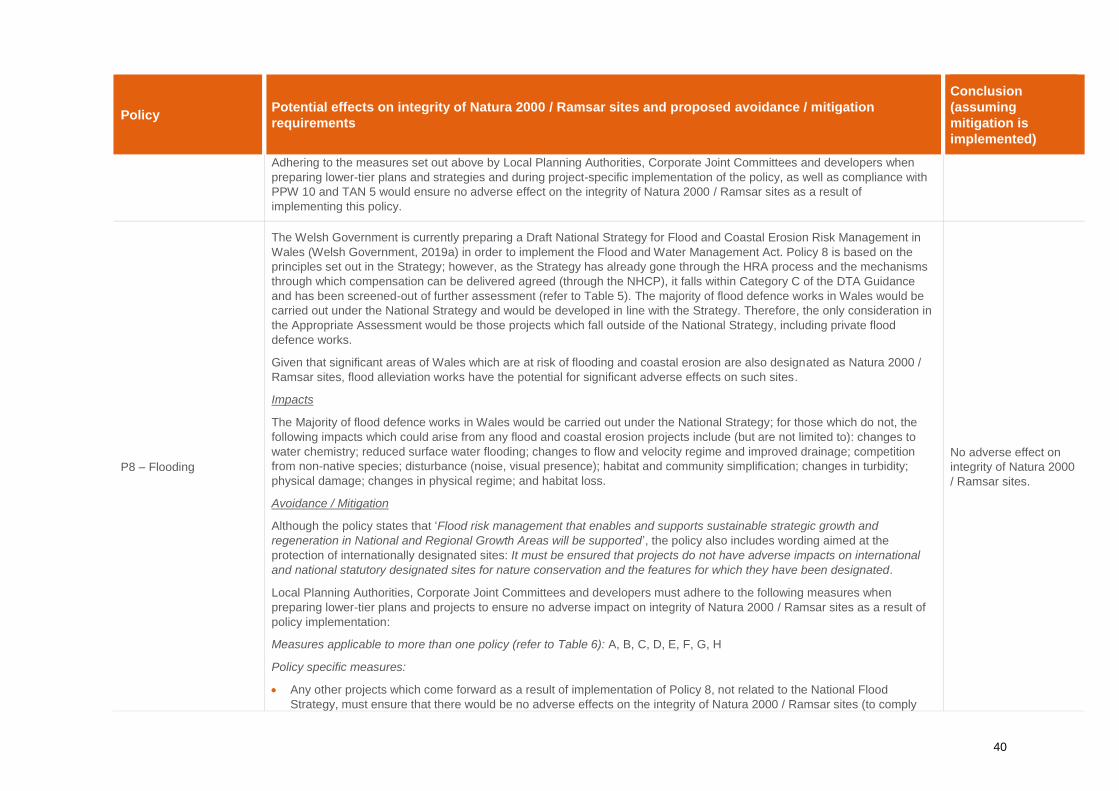
40
Policy Potential effects on integrity of Natura 2000 / Ramsar sites and proposed avoidance / mitigation
requirements
Conclusion
(assuming
mitigation is
implemented)
Adhering to the measures set out above by Local Planning Authorities, Corporate Joint Committees and developers when
preparing lower-tier plans and strategies and during project-specific implementation of the policy, as well as compliance with
PPW 10 and TAN 5 would ensure no adverse effect on the integrity of Natura 2000 / Ramsar sites as a result of
implementing this policy.
P8 – Flooding
The Welsh Government is currently preparing a Draft National Strategy for Flood and Coastal Erosion Risk Management in
Wales (Welsh Government, 2019a) in order to implement the Flood and Water Management Act. Policy 8 is based on the
principles set out in the Strategy; however, as the Strategy has already gone through the HRA process and the mechanisms
through which compensation can be delivered agreed (through the NHCP), it falls within Category C of the DTA Guidance
and has been screened-out of further assessment (refer to Table 5). The majority of flood defence works in Wales would be
carried out under the National Strategy and would be developed in line with the Strategy. Therefore, the only consideration in
the Appropriate Assessment would be those projects which fall outside of the National Strategy, including private flood
defence works.
Given that significant areas of Wales which are at risk of flooding and coastal erosion are also designated as Natura 2000 /
Ramsar sites, flood alleviation works have the potential for significant adverse effects on such sites.
Impacts
The Majority of flood defence works in Wales would be carried out under the National Strategy; for those which do not, the
following impacts which could arise from any flood and coastal erosion projects include (but are not limited to): changes to
water chemistry; reduced surface water flooding; changes to flow and velocity regime and improved drainage; competition
from non-native species; disturbance (noise, visual presence); habitat and community simplification; changes in turbidity;
physical damage; changes in physical regime; and habitat loss.
Avoidance / Mitigation
Although the policy states that ‘Flood risk management that enables and supports sustainable strategic growth and
regeneration in National and Regional Growth Areas will be supported’, the policy also includes wording aimed at the
protection of internationally designated sites: It must be ensured that projects do not have adverse impacts on international
and national statutory designated sites for nature conservation and the features for which they have been designated.
Local Planning Authorities, Corporate Joint Committees and developers must adhere to the following measures when
preparing lower-tier plans and projects to ensure no adverse impact on integrity of Natura 2000 / Ramsar sites as a result of
policy implementation:
Measures applicable to more than one policy (refer to Table 6): A, B, C, D, E, F, G, H
Policy specific measures:
Any other projects which come forward as a result of implementation of Policy 8, not related to the National Flood
Strategy, must ensure that there would be no adverse effects on the integrity of Natura 2000 / Ramsar sites (to comply
No adverse effect on
integrity of Natura 2000
/ Ramsar sites.

41
Policy Potential effects on integrity of Natura 2000 / Ramsar sites and proposed avoidance / mitigation
requirements
Conclusion
(assuming
mitigation is
implemented)
with PPW 10 and TAN 5). The buffers set out in Section 1.5 should be used to help identify the Natura 2000 / Ramsar
sites which could be impacted by future development under this policy. The NDF does not support any proposals
associated with this policy where adverse effects on Natura 2000 / Ramsar sites cannot be avoided through mitigation.
If there is the potential for flood alleviation projects (not related to the National Strategy) to adversely impact on Natura
2000 / Ramsar sites (such as coastal schemes), these should be withdrawn or amended and re-assessed or pass the
derogations set out under Article 6(4) of the Habitats Regulations, namely no alternative solutions, IROPI and
compensatory measures secured.
Conclusion
Adhering to the measures set out above by Local Planning Authorities, Corporate Joint Committees and developers when
preparing lower-tier plans and strategies and during project-specific implementation of the policy, as well as compliance with
PPW 10 and TAN 5 would ensure no adverse effect on the integrity of Natura 2000 / Ramsar sites as a result of
implementing this policy.
P9 – Resilient Ecological
Networks and Green
Infrastructure
Overall, this policy will provide many positive environmental outcomes, promoting enhancement of biodiversity and
safeguarding ecological networks. The development and maximising of Green Infrastructure will also lead to positive
environmental benefits, including linking existing and new habitat areas to create a green network across Wales. However, if
Green Infrastructure is developed in unsuitable locations, incompatible with the conservation objectives for Natura 2000 /
Ramsar sites, there is the potential for significant adverse effects on such sites.
Impacts
As there is no spatial element to the policy, it is not possible to determine which Natura 2000 / Ramsar sites could be affected
by Green Infrastructure development; however, if it is located in unsuitable places, implementation of the policy could
potentially lead to detrimental impacts on existing habitats and species. Potential impacts could include (but are not limited
to): scrub encroachment onto open habitats such as heathland or grassland; planting woodland adjacent to sensitive habitats
could also have adverse effects, especially if species from those sites depend upon similarly open habitats beyond the site
boundaries (e.g. for foraging or roosting). Changing habitats adjacent to sensitive sites could provide cover for predators of
the qualifying species (in particular ground nesting birds) or could potentially affect the hydrology of the landscape, which
could adversely affect wetland sites. Increasing the number of visitors to Green Infrastructure has many positive benefits in
terms of supporting physical and mental well-being; however, this could also have detrimental impacts associated with
recreational pressure (such as disturbance from increased human presence and dog walkers).
Avoidance / Mitigation
It is clearly important to ensure that sites selected to support the delivery of this policy are not already designated for the
presence of other habitats which would be compromised by new Green Infrastructure. Although the exact locations of Green
Infrastructure enhancement or expansion projects is not currently known, Green Infrastructure Assessments, as well as
ecological network and green infrastructure mapping, will be used to identify potential areas for improvement. These
No adverse effect on
integrity of Natura 2000
/ Ramsar sites.
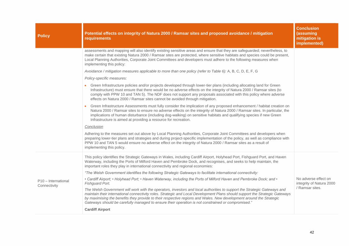
42
Policy Potential effects on integrity of Natura 2000 / Ramsar sites and proposed avoidance / mitigation
requirements
Conclusion
(assuming
mitigation is
implemented)
assessments and mapping will also identify existing sensitive areas and ensure that they are safeguarded; nevertheless, to
make certain that existing Natura 2000 / Ramsar sites are protected, where sensitive habitats and species could be present,
Local Planning Authorities, Corporate Joint Committees and developers must adhere to the following measures when
implementing this policy:
Avoidance / mitigation measures applicable to more than one policy (refer to Table 6): A, B, C, D, E, F, G
Policy-specific measures:
Green Infrastructure policies and/or projects developed through lower-tier plans (including allocating land for Green
Infrastructure) must ensure that there would be no adverse effects on the integrity of Natura 2000 / Ramsar sites (to
comply with PPW 10 and TAN 5). The NDF does not support any proposals associated with this policy where adverse
effects on Natura 2000 / Ramsar sites cannot be avoided through mitigation.
Green Infrastructure Assessments must fully consider the implication of any proposed enhancement / habitat creation on
Natura 2000 / Ramsar sites to ensure no adverse effects on the integrity of Natura 2000 / Ramsar sites. In particular, the
implications of human disturbance (including dog-walking) on sensitive habitats and qualifying species if new Green
Infrastructure is aimed at providing a resource for recreation.
Conclusion
Adhering to the measures set out above by Local Planning Authorities, Corporate Joint Committees and developers when
preparing lower-tier plans and strategies and during project-specific implementation of the policy, as well as compliance with
PPW 10 and TAN 5 would ensure no adverse effect on the integrity of Natura 2000 / Ramsar sites as a result of
implementing this policy.
P10 – International
Connectivity
This policy identifies the Strategic Gateways in Wales, including Cardiff Airport, Holyhead Port, Fishguard Port, and Haven
Waterway, including the Ports of Milford Haven and Pembroke Dock, and recognises, and seeks to help maintain, the
important roles they play in international connectivity and regional economies:
“The Welsh Government identifies the following Strategic Gateways to facilitate international connectivity:
• Cardiff Airport; • Holyhead Port; • Haven Waterway, including the Ports of Milford Haven and Pembroke Dock; and • Fishguard Port.
The Welsh Government will work with the operators, investors and local authorities to support the Strategic Gateways and maintain their international connectivity roles. Strategic and Local Development Plans should support the Strategic Gateways by maximising the benefits they provide to their respective regions and Wales. New development around the Strategic Gateways should be carefully managed to ensure their operation is not constrained or compromised.”
Cardiff Airport
No adverse effect on
integrity of Natura 2000
/ Ramsar sites.

43
Policy Potential effects on integrity of Natura 2000 / Ramsar sites and proposed avoidance / mitigation
requirements
Conclusion
(assuming
mitigation is
implemented)
Cardiff Airport has been recognised as an essential part of Wales’ strategic transport infrastructure. Successfully maintaining
the international connectivity role, could require new and improved airport facilities and passengers’ services to be delivered
over the course of the NDF, including integration with the South Wales Metro (Policy 36) and improvements to pedestrian and
cycle access. Policy P10 could therefore potentially facilitate the expansion of Cardiff Airport. Whilst there is uncertainty as to
any future development, in accordance with the precautionary principle, it is appropriate to assume that there is potential for
an expansion of services and therefore the need to identify the potential implications of this for Natura 2000 / Ramsar sites as
a result of implementing this policy.
Impacts (Cardiff Airport)
The Severn Estuary SPA / Ramsar site/SAC is located to the east of the airport. Although direct impacts (such as habitat
loss) on the habitat features of the SPA / Ramsar site/SAC can be ruled out. Any expansion of airport capacity in terms of
increased flights and its associated infrastructure could have much wider environmental effects (including outside of Wales),
and the potential implications for Natura 2000 / Ramsar sites would extend much further than for smaller-scale, ground-based
development.
The airport and Enterprise Zone were included within the Vale of Glamorgan Local Development Plan 2011 – 2026 (Vale of
Glamorgan, June 2017). ‘St Athan – Cardiff Airport Enterprise Zone’ is a Strategic Opportunities Area (Policy MG10) within
the LDP. A HRA of the LDP (Vale of Glamorgan, 2016) was carried out in 2016 which identified the potential for adverse
impacts associated with implementing Policy MG10 related to air quality and recreation. The subsequent Appropriate
Assessment of Policy MG10 concluded that ‘as the site is located a considerable distance from any European sites (around
12km [from the Severn Estuary SPA/Ramsar site/SAC]), it is therefore considered to have no significant effects alone.’ In
respect of in-combination effects, the Appropriate Assessment ‘did not identify any in-combination effects in relation to air
pollution, disturbance, water resources or water quality.’ The Vale of Glamorgan have also produced a Supplementary
Planning Guidance document (The Vale of Glamorgan Local Development Plan Supplementary Planning Guidance: Cardiff
Airport and Gateway Development Zone, December 2019) which includes provision to ensure ‘a Preliminary Ecological
Appraisal of the site to establish what further surveys and assessments will be required to inform the development.’ Policy
MG10 was based on a Masterplan from 2006 (Cardiff Airport, 2006), and subsequently a new Masterplan has been
developed. The 2040 Masterplan for the airport has been produced by the Welsh Government (Welsh Government, June
2019). HRA has not been carried out on the Masterplan at this stage. The Cardiff Airport Masterplan states that: ‘We propose
to support an integrated and sustainable low-carbon transport infrastructure. We will deliver increased choice for those who
work at, visit and use the Airport; offering phased active travel links, electric bus infrastructure, electric bikes for hire, electric
vehicle charging points and bus rapid transit links to the planned campus. In addition, a sustainable and long-term approach
to development is envisaged, utilising solar technology, sustainable building materials and cleaner technologies.’ Although
similar to the St Athan – Cardiff Airport Enterprise Zone’ allocation within the LDP, the new Masterplan includes a revised
larger boundary (to take account of a potential extended runway) and project projections (in terms of growth - the Masterplan
forecast growth shows that passenger numbers could reach 2.5 million in the next 10 years rising to 3.3 million by 2040,
whereas MG10 states that the Welsh Government is committed to re-establishing passenger trips to 2.5 million by 2023,
therefore the 2006 Masterplan was based on around double the amount of passenger numbers as currently proposed in the

44
Policy Potential effects on integrity of Natura 2000 / Ramsar sites and proposed avoidance / mitigation
requirements
Conclusion
(assuming
mitigation is
implemented)
2040 Masterplan). Given the early stages of the Masterplan, no projects have come forward at this time; however,
consideration of the impacts identified in the LDP HRA will need to be given to any future development associated with Policy
MG 10 or through the new Masterplan. This could include: air pollution as a result of additional flights and increased traffic
flow of passengers to and from the airport; loss of land potentially suitable for use by foraging / roosting birds associated with
the Severn Estuary SPA / Ramsar site as a result of the potential runway extension and its associated infrastructure;
disturbance / displacement effects (noise / visual) upon foraging qualifying features associated with the Severn Estuary SPA /
Ramsar site using land functionally linked to the Natura 2000 / Ramsar site (in particular over-wintering waders and
waterfowl) associated with the operation of the airport, or as a result of construction activities from the airport expansion,
including the potential runway extension and associated infrastructure; indirect effects such as increased recreational
pressures on the region through additional tourism; potential impacts on water quality and resources as a result of new
infrastructure associated with the airport expansion; and potential in-combination effects with other large-scale projects
regionally / nationally. The 2006 Masterplan included an assessment of the local air quality as a result of projected airport
travel, although the new Masterplan includes a revised lower projection and therefore potential reduction in air quality
impacts, similar air quality assessments will be required at the project-level to ensure no adverse air quality impacts on
Natura 2000 / Ramsar sites (alone or in-combination with other large-scale development). The NDF does not support any
proposals associated with Cardiff Airport where adverse effects on Natura 2000 / Ramsar sites cannot be avoided through
mitigation.
Avoidance / Mitigation (Cardiff Airport)
Whilst the LDP concludes no adverse effect on Natura 2000 / Ramsar sites (as a result of implementation of Policy MG10
within the LDP), given that the 2040 Masterplan includes a revised boundary and project projections, the conclusion of the
LDP cannot be solely relied upon to conclude no adverse effects of Policy 10 of the NDF. However, given the probable size
and scale of future development at the airport, project-level HRA is likely to be required (to comply with PPW 10) which would
identify any other impacts not considered in the LDP HRA (such as those associated with the runway extension).
Infrastructure development associated with Cardiff Airport would also be the requirements of HRA at the appropriate planning
stage. Although this provides assurance that applications will be required to show that they have assessed the potential
impacts on Natura 2000 / Ramsar sites, the following measures must be adhered to when future development at the Airport
and its associated infrastructure come forward (either as part of Policy MG10 or the new Masterplan) to ensure no adverse
impact on the integrity of Natura 2000 / Ramsar sites.
Avoidance / mitigation measures applicable to more than one policy (refer to Table 6): A to H
Policy-specific measures:
Projects related to the expansion of Cardiff Airport must ensure that there would be no adverse effects on the integrity of
Natura 2000 / Ramsar sites (to comply with PPW 10 and TAN 5). The buffers set out in Section 1.5 should be used to
help identify the Natura 2000 / Ramsar sites which could be impacted by future development under this policy. Future
developers must be able to demonstrate that any mitigation measures deemed necessary during project level HRA can
be delivered. If the project-level HRA cannot rule out adverse effects on site integrity, the project will either have to be
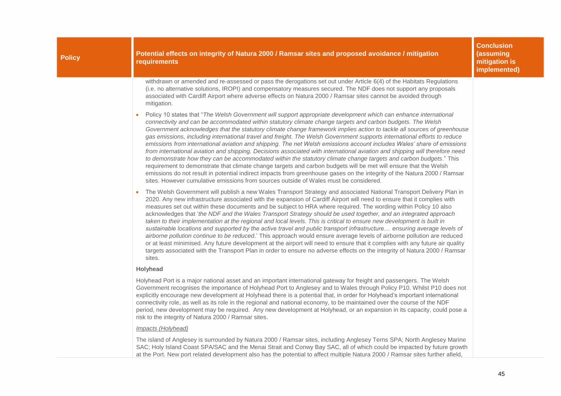
45
Policy Potential effects on integrity of Natura 2000 / Ramsar sites and proposed avoidance / mitigation
requirements
Conclusion
(assuming
mitigation is
implemented)
withdrawn or amended and re-assessed or pass the derogations set out under Article 6(4) of the Habitats Regulations
(i.e. no alternative solutions, IROPI) and compensatory measures secured. The NDF does not support any proposals
associated with Cardiff Airport where adverse effects on Natura 2000 / Ramsar sites cannot be avoided through
mitigation.
Policy 10 states that “The Welsh Government will support appropriate development which can enhance international
connectivity and can be accommodated within statutory climate change targets and carbon budgets. The Welsh
Government acknowledges that the statutory climate change framework implies action to tackle all sources of greenhouse
gas emissions, including international travel and freight. The Welsh Government supports international efforts to reduce
emissions from international aviation and shipping. The net Welsh emissions account includes Wales’ share of emissions
from international aviation and shipping. Decisions associated with international aviation and shipping will therefore need
to demonstrate how they can be accommodated within the statutory climate change targets and carbon budgets.” This
requirement to demonstrate that climate change targets and carbon budgets will be met will ensure that the Welsh
emissions do not result in potential indirect impacts from greenhouse gases on the integrity of the Natura 2000 / Ramsar
sites. However cumulative emissions from sources outside of Wales must be considered.
The Welsh Government will publish a new Wales Transport Strategy and associated National Transport Delivery Plan in
2020. Any new infrastructure associated with the expansion of Cardiff Airport will need to ensure that it complies with
measures set out within these documents and be subject to HRA where required. The wording within Policy 10 also
acknowledges that ‘the NDF and the Wales Transport Strategy should be used together, and an integrated approach
taken to their implementation at the regional and local levels. This is critical to ensure new development is built in
sustainable locations and supported by the active travel and public transport infrastructure… ensuring average levels of
airborne pollution continue to be reduced.’ This approach would ensure average levels of airborne pollution are reduced
or at least minimised. Any future development at the airport will need to ensure that it complies with any future air quality
targets associated with the Transport Plan in order to ensure no adverse effects on the integrity of Natura 2000 / Ramsar
sites.
Holyhead
Holyhead Port is a major national asset and an important international gateway for freight and passengers. The Welsh
Government recognises the importance of Holyhead Port to Anglesey and to Wales through Policy P10. Whilst P10 does not
explicitly encourage new development at Holyhead there is a potential that, in order for Holyhead’s important international
connectivity role, as well as its role in the regional and national economy, to be maintained over the course of the NDF
period, new development may be required. Any new development at Holyhead, or an expansion in its capacity, could pose a
risk to the integrity of Natura 2000 / Ramsar sites.
Impacts (Holyhead)
The island of Anglesey is surrounded by Natura 2000 / Ramsar sites, including Anglesey Terns SPA; North Anglesey Marine
SAC; Holy Island Coast SPA/SAC and the Menai Strait and Conwy Bay SAC, all of which could be impacted by future growth
at the Port. New port related development also has the potential to affect multiple Natura 2000 / Ramsar sites further afield,

46
Policy Potential effects on integrity of Natura 2000 / Ramsar sites and proposed avoidance / mitigation
requirements
Conclusion
(assuming
mitigation is
implemented)
including sites designated for marine mammals such as West Wales Marine SAC; Bristol Channel Approaches SAC; Lleyn
Peninsula and the Sarnau SAC; Cardigan Bay SAC; and Pembrokeshire Marine SAC.
Ecological assessment (including HRA Screening) has already been carried out for a Draft Harbour Revisions Order (HRO)
for the potential expansion of Holyhead Port. Potential impacts identified included: disturbance/displacement effects (noise/
visual/vibration) upon breeding and/or foraging qualifying features of the marine sites (including harbour porpoise and
breeding terns); loss/damage to sensitive marine and coastal habitats; potential impacts to foraging and/or breeding habitats
associated with changes to coastal processes; potential increases in air pollution through construction activities and/or
increased boat traffic; potential impacts on water quality (such as pollution within the marine environment from construction
activities, dredging, or increased boat traffic); indirect effects such as increased recreational pressures on the coastline
through additional tourism to the area; and potential in-combination effects with other large-scale coastal projects regionally /
nationally. The HRA Screening (Royal Haskoning, June 2019) identified the potential for likely significant effects on marine
mammals (including Harbour porpoise, bottlenose dolphin and grey seal). Further Appropriate Assessment for these
qualifying species is currently being carried out.
Avoidance / Mitigation (Holyhead)
Whilst the HRA of the HRO will include mitigation measures to ensure no adverse effect on Natura 2000 / Ramsar sites, other
projects at the port could come forward as a result of Policy 10 during the NDF plan period, not related to the HRO; therefore,
the conclusion of the HRO HRA cannot be solely relied upon to conclude no adverse effects of Policy 10 of the NDF.
However, given the likely size of any future development at the port, project-level HRA is likely to be required (to comply with
PPW 10) which would identify any other impacts not considered in the HRO HRA. Infrastructure development associated with
Holyhead would also be subject to the requirements of HRA at the appropriate planning stage. Although this provides
assurance that applications will be required to show that they have assessed the potential impacts on Natura 2000 / Ramsar
sites, the following measures must be adhered to (when future port related projects come forward) to ensure no adverse
impact on integrity of Natura 2000 / Ramsar sites.
Avoidance / mitigation measures applicable to more than one policy (refer to Table 6): A to H
Policy-specific measures:
Projects related to the expansion of Holyhead Port (including the HRO referred to above) must ensure that there would be
no adverse effects on the integrity of Natura 2000 / Ramsar sites (to comply with PPW 10 and TAN 5). The buffers set out
in Section 1.5 should be used to help identify the Natura 2000 / Ramsar sites which could be impacted by future
development under this policy. Future developers must be able to demonstrate that any mitigation measures deemed
necessary during project-level HRA can be delivered. If the project-level HRA cannot rule out adverse effects on site
integrity, the project will either have to be withdrawn or amended and re-assessed or pass the derogations set out under
Article 6(4) of the Habitats Regulations (i.e. no alternative solutions, IROPI) and compensatory measures secured. The
NDF does not support any proposals associated with Holyhead Port where adverse effects on Natura 2000 / Ramsar sites
cannot be avoided through mitigation.
47
Policy Potential effects on integrity of Natura 2000 / Ramsar sites and proposed avoidance / mitigation
requirements
Conclusion
(assuming
mitigation is
implemented)
Policy 10 states that “The Welsh Government will support appropriate development which can enhance international
connectivity and can be accommodated within statutory climate change targets and carbon budgets. The Welsh
Government acknowledges that the statutory climate change framework implies action to tackle all sources of greenhouse
gas emissions, including international travel and freight. The Welsh Government supports international efforts to reduce
emissions from international aviation and shipping. The net Welsh emissions account includes Wales’ share of emissions
from international aviation and shipping. Decisions associated with international aviation and shipping will therefore need
to demonstrate how they can be accommodated within the statutory climate change targets and carbon budgets.” This
requirement to demonstrate that climate change targets and carbon budgets will be met will ensure that the Welsh
emission do not result in potential indirect impacts from greenhouse gases on the integrity of the Natura 2000 / Ramsar
sites. However cumulative emissions from sources outside of Wales must be considered.
The Welsh Government will publish a new Wales Transport Strategy and associated National Transport Delivery Plan in
2020. Any new infrastructure associated with the expansion of the Port will need to ensure that it complies with measures
set out within these documents and be subject to HRA where required.
Haven Waterway
Policy P10 recognises the importance of Haven Waterway for the regional economy, as well as Wales’ national economy,
and its role in international connectivity. P10 seeks to ensure that these important roles of Haven Waterway are maintained
over the NDF period. Whilst this does not necessarily mean that new development, or an expansion of Haven Waterway’s
capacity, would take place, there is potential that such development could occur. Any new development at Haven Waterway,
or an expansion in its capacity, could pose a risk to the integrity of Natura 2000 / Ramsar sites.
Impacts (Haven Waterway)
Although the Haven Waterway is an existing port with long-established industries and a key location for the UK’s energy
supplies, it also forms part of the West Wales Marine SAC and Pembrokeshire Marine SAC. Any expansion of the port has
the potential to impact on the adjacent SACs, as well as Natura 2000 / Ramsar sites further afield, including sites designated
for marine mammals such as Bristol Channel Approaches SAC; Lleyn Peninsula and the Sarnau SAC; and Cardigan Bay
SAC.
Haven Waterway was included as an allocation within the Pembrokeshire Local Development Plan (Pembrokeshire Council,
2013). Policy SP2 (Port and Energy related development) within the LDP includes development at the Ports of Milford Haven
and Fishguard. The policy states that development will be permitted for port related facilities and infrastructure, including
energy related development. A HRA of the LDP was carried out in 2012 (Pembrokeshire Council, 2012). Potential impacts
identified included: disturbance/displacement effects (noise/visual/vibration) upon breeding and/or foraging qualifying features
of the marine sites; loss/damage to sensitive marine and coastal habitats (in particular the adjacent SACs); potential impacts
to foraging and/or breeding habitats associated with changes to coastal processes; potential increases in air pollution through
construction activities and/or increased boat traffic; potential impacts on water quality (such as pollution within the marine
environment from construction activities, dredging or increased boat traffic); indirect effects such as increased recreational

48
Policy Potential effects on integrity of Natura 2000 / Ramsar sites and proposed avoidance / mitigation
requirements
Conclusion
(assuming
mitigation is
implemented)
pressures on the coastline through additional tourism to the area; and potential in-combination effects with other large-scale
coastal projects regionally / nationally. The HRA of the LDP concluded that implementation of Policy SP2 would have no
impacts on Natura 2000 / Ramsar sites, assuming project-level HRA was undertaken to identify and mitigate any potential
adverse impacts. Policy SP2 states that ‘Individual proposals coming forward under policy SP2 will require project level
Habitats Regulation Assessment to consider their likely significant effects on features of the SAC.’ This is achieved through
Policy GN36 within the LDP which states that ‘Development Proposals with potential for adverse effect on internationally or
nationally important sites will require detailed assessment before progressing. Specifically, if any development proposal is
likely to have a significant effect on a European protected site or species it shall be subject to an Appropriate Assessment of
the implications in relation to the site’s conservation objectives.’ A planning application associated with the Port of Milford
Haven Master Plan is also currently in the planning system. The Preliminary Ecological Appraisal for the Masterplan (RSK,
2018) identifies that project-level HRA Screening will be carried out once the details of the Masterplan have been finalised.
Avoidance / Mitigation (Haven Waterway)
Whilst the HRA of the LDP concludes no adverse effect on Natura 2000 / Ramsar sites (with mitigation in place), other
projects at the port could come forward as a result of Policy 10 during the NDF plan period, outside of the boundary of Policy
SP2 within the LDP; therefore, the conclusion of the LDP HRA cannot be solely relied upon to conclude no adverse effects of
Policy 10 of the NDF. However, given the likely size of future development at the port, project-level HRA is likely to be
required (to comply with PPW 10) which would identify any other impacts not considered in the LDP HRA. Infrastructure
development associated with Haven Waterway would also be subject to requirements of HRA at the appropriate planning
stage. Although this provides assurance that applications will be required to show that they have assessed the potential
impacts on Natura 2000 / Ramsar sites, the following measures must be adhered to (when future port related projects come
forward) to ensure no adverse impact on integrity of Natura 2000 / Ramsar sites.
Avoidance / mitigation measures applicable to more than one policy (refer to Table 6): A to H
Policy-specific measures:
Projects related to development at Haven Waterway must ensure that there would be no adverse effects on the integrity
of Natura 2000 / Ramsar sites (to comply with PPW 10 and TAN 5 and Policy GN36 of the Pembrokeshire LDP). The
buffers set out in Section 1.5 should be used to help identify the Natura 2000 / Ramsar sites which could be impacted by
future development under this policy. Future developers must be able to demonstrate that any mitigation measures
deemed necessary during project level HRA can be delivered. If the project-level HRA cannot rule out adverse effects on
site integrity, the project will either have to be withdrawn or amended and re-assessed or pass the derogations set out
under Article 6(4) of the Habitats Regulations (i.e. no alternative solutions, IROPI) and compensatory measures secured.
The NDF does not support any proposals associated with Haven Waterway where adverse effects on Natura 2000 /
Ramsar sites cannot be avoided through mitigation.
Policy 10 states that “The Welsh Government will support appropriate development which can enhance international
connectivity and can be accommodated within statutory climate change targets and carbon budgets. The Welsh
Government acknowledges that the statutory climate change framework implies action to tackle all sources of greenhouse

49
Policy Potential effects on integrity of Natura 2000 / Ramsar sites and proposed avoidance / mitigation
requirements
Conclusion
(assuming
mitigation is
implemented)
gas emissions, including international travel and freight. The Welsh Government supports international efforts to reduce
emissions from international aviation and shipping. The net Welsh emissions account includes Wales’ share of emissions
from international aviation and shipping. Decisions associated with international aviation and shipping will therefore need
to demonstrate how they can be accommodated within the statutory climate change targets and carbon budgets.” This
requirement to demonstrate that climate change targets and carbon budgets will be met will ensure that the Welsh
emissions do not result in potential indirect impacts from greenhouse gases on the integrity of the Natura 2000 / Ramsar
sites. However cumulative emissions from sources outside of Wales must be considered.
The Welsh Government will publish a new Wales Transport Strategy and associated National Transport Delivery Plan in
2020. Any new infrastructure associated with the expansion of the Port will need to ensure that it complies with measures
set out within these documents and be subject to HRA where required.
Fishguard Port
The Welsh Government recognises the importance of the port as an important international gateway for freight and
passengers in South-West Wales and provides a key roll-on roll-off ferry link. It has a strategically important role in
connecting the mainland of Europe, the UK and Wales with the Republic of Ireland. It also plays an important role in the
regional and national economies. Policy P10 seeks to ensure that these important roles of the port are maintained over the
NDF period. Whilst Policy P10 does not explicitly encourage new development at the port, or an expansion of its capacity,
there is potential that such development may be needed in order to maintain the Port’s important connectivity and economic
roles. Any new development at Fishgard Port, or an expansion in its capacity, could pose a risk to the integrity of Natura 2000
/ Ramsar sites.
Impacts (Fishguard Port)
Although Fishguard is a working Port, it also forms part of the West Wales Marine SAC. Any expansion of the port has the
potential to impact on the adjacent SAC, as well as Natura 2000 / Ramsar sites further afield, including sites designated for
marine mammals such as Bristol Channel Approaches SAC; Pembrokeshire Marine SAC, Lleyn Peninsula and the Sarnau
SAC; and Cardigan Bay SAC
Fishguard is also included under Policy SP2 within the Pembrokeshire Local Development Plan (Pembrokeshire Council,
2013) linked to Milford Haven (see above). Potential impacts of future development of the Port identified include: disturbance
/ displacement effects (noise/visual/vibration) upon breeding and/or foraging qualifying features of the marine sites; loss /
damage to sensitive marine and coastal habitats (in particular the adjacent SAC); potential impacts to foraging and/or
breeding habitats associated with changes to coastal processes; potential increases in air pollution through construction
activities and/or increased boat traffic; potential impacts on water quality (such as pollution within the marine environment
from construction activities, dredging or increased boat traffic); indirect effects such as increased recreational pressures on
the coastline through additional tourism to the area; and potential in-combination effects with other large-scale coastal
projects regionally / nationally. As stated above, the HRA of the LDP concluded that implementation of Policy SP2 would

50
Policy Potential effects on integrity of Natura 2000 / Ramsar sites and proposed avoidance / mitigation
requirements
Conclusion
(assuming
mitigation is
implemented)
have no impacts on Natura 2000 / Ramsar sites, assuming project-level HRA was undertaken to identify and mitigate any
potential adverse impacts.
Avoidance / Mitigation (Fishguard Port)
Whilst the HRA of the LDP concludes no adverse effect on Natura 2000 / Ramsar sites (with mitigation in place), other
projects at the port could come forward as a result of Policy 10 during the NDF plan period, outside of the boundary of Policy
SP2 within the LDP; therefore, the conclusion of the LDP HRA cannot be solely relied upon to conclude no adverse effects of
Policy 10 of the NDF. However, given the likely size of future development at the port, project-level HRA is likely to be
required (to comply with PPW 10) which would identify any other impacts not considered in the LDP HRA. Infrastructure
development associated with Fishguard Port would also be subject to the requirements of HRA at the appropriate planning
stage. Although this provides assurance that applications will be required to show that they have assessed the potential
impacts on Natura 2000 / Ramsar sites, the following measures must be adhered to (when future port related projects come
forward) to ensure no adverse impact on integrity of Natura 2000 / Ramsar sites.
Avoidance / mitigation measures applicable to more than one policy (refer to Table 6): A to H
Policy-specific measures:
Projects related to development at Fishguard Port must ensure that there would be no adverse effects on the integrity of
Natura 2000 / Ramsar sites (to comply with PPW 10 and TAN 5 and Policy GN36 of the Pembrokeshire LDP). The buffers
set out in Section 1.5 should be used to help identify the Natura 2000 / Ramsar sites which could be impacted by future
development under this policy. Future developers must be able to demonstrate that any mitigation measures deemed
necessary during project level HRA can be delivered. If the project-level HRA cannot rule out adverse effects on site
integrity, the project will either have to be withdrawn or amended and re-assessed or pass the derogations set out under
Article 6(4) of the Habitats Regulations (i.e. no alternative solutions, IROPI) and compensatory measures secured. The
NDF does not support any proposals associated with Fishguard Port where adverse effects on Natura 2000 / Ramsar
sites cannot be avoided through mitigation.
Policy 10 states that “The Welsh Government will support appropriate development which can enhance international
connectivity and can be accommodated within statutory climate change targets and carbon budgets. The Welsh
Government acknowledges that the statutory climate change framework implies action to tackle all sources of greenhouse
gas emissions, including international travel and freight. The Welsh Government supports international efforts to reduce
emissions from international aviation and shipping. The net Welsh emissions account includes Wales’ share of emissions
from international aviation and shipping. Decisions associated with international aviation and shipping will therefore need
to demonstrate how they can be accommodated within the statutory climate change targets and carbon budgets.” This
requirement to demonstrate that climate change targets and carbon budgets will be met will ensure that the Welsh
emissions do not result in potential indirect impacts from greenhouse gases on the integrity of the Natura 2000 / Ramsar
sites. However cumulative emissions from sources outside of Wales must be considered.

51
Policy Potential effects on integrity of Natura 2000 / Ramsar sites and proposed avoidance / mitigation
requirements
Conclusion
(assuming
mitigation is
implemented)
The Welsh Government will publish a new Wales Transport Strategy and associated National Transport Delivery Plan in
2020. Any new infrastructure associated with the expansion of the Port will need to ensure that it complies with measures
set out within these documents and be subject to HRA where required.
Conclusion
Adhering to the measures set out above by Local Planning Authorities, Corporate Joint Committees and developers when
preparing lower-tier plans and strategies and during project-specific implementation of the policy, as well as compliance with
PPW 10 and TAN 5 would ensure no adverse effect on the integrity of Natura 2000 / Ramsar sites as a result of
implementing this policy.
P11 - National
Connectivity
This policy sets out the Welsh Government’s support for investment in improving national connectivity. The Welsh
Government aims to reduce the need to travel, particularly by private vehicles, and support a modal shift to walking, cycling
and public transport (a fundamental principle of PPW 10). Broadly, this policy will provide positive environmental outcomes
through reducing air pollution from car emissions and focusing new infrastructure and transport links within existing urban
locations. However, given that the exact details of such improvements are not currently known at the high-level of the NDF,
there is still the potential for adverse impacts on Natura 2000 / Ramsar sites.
Impacts
Whilst the majority of upgrades to the cycle, road and rail routes would be linked to the existing network (for example,
improving and linking cycle routes and widening roads), the requirement for larger infrastructure, such as new cycle paths,
roads and railway lines could lead to potential impacts on Natura 2000 / Ramsar sites should they be located within or close
to such areas.
The policy states that ‘planning authorities must ensure that, where appropriate, new development contributes towards the
improvement and development of the National Cycle Network and key links to and from it.’ The National Cycle Network
crosses large areas of Wales covering 1,690 miles (64% of the network is on-road and 36% is on traffic-free paths) and by its
nature many traffic-free cycle routes are located in coastal areas and in the vicinity of Natura 2000 / Ramsar sites. Potential
impacts associated with the improvement and development of the National Cycle Network or upgrades to link into it could
include (but are not limited to): disturbance / displacement of qualifying species (in particular birds in coastal areas or using
functionally linked land) if new routes are opened up adjacent to Natura 2000 / Ramsar sites; potential direct loss of
functionally linked land under the footprint of schemes adjacent to coastal areas; and potential severance of habitat links from
new linear features in the landscape. There is also the potential to open up previously less accessible areas to new visitors
and as such increase the potential for recreational pressure on Natura 2000 / Ramsar sites.
Although the exact details of the upgrades to the rail network are not known at this stage, the Welsh Government has
produced a report (‘A Railway for Wales: Meeting the needs of future generations (Welsh Government, 2019c)) which sets
out a Strategic Railway Development Programme. This includes improving existing services, station upgrades and better
timetabling across Wales. Station improvements, which would generally be focused in urban locations, are unlikely to lead to
No adverse effect on
integrity of Natura 2000
/ Ramsar sites

52
Policy Potential effects on integrity of Natura 2000 / Ramsar sites and proposed avoidance / mitigation
requirements
Conclusion
(assuming
mitigation is
implemented)
adverse impacts on Natura 2000 / Ramsar sites. The main potential impact of rail improvements would be associated with
potential increases in recreation pressure if access to coastal areas, for example, are improved. Works associated with the
electrification of the rail network also have the potential to cause temporary disturbance / displacement and/or water quality
impacts if located in the vicinity of Natura 2000 / Ramsar sites. The construction of new track, if required, also has the
potential to cause disturbance / displacement of qualifying species (as a result of construction activities as well as the
operation of the new lines); potential direct loss of functionally linked land under the footprint of new rail routes; and potential
severance of habitat links from new linear features in the landscape.
Whilst the details of road improvements are not known at this stage, the Welsh Government maintains its commitment to
tackling congestion on the trunk road network and the Pinch Point Programme identifies areas of congestion. Potential
impacts associated with new road building and improvement projects could include (but are not limited to): disturbance /
displacement to qualifying features if such development falls in the vicinity of Natura 2000 / Ramsar sites; water and air
pollution from construction activities, and potential increases in recreational pressure if new roads open up access to
previously undisturbed areas. There is also the potential to open up previously less accessible areas to new visitors and as
such increase the potential for recreational pressure on Natura 2000 / Ramsar sites.
Avoidance / Mitigation
The main focus of the policy is to reduce the need to travel and thus implementation in itself could potentially lead to
improvements in air quality which would bring benefits to Natura 2000 / Ramsar sites. However, where there is the potential
to impact Natura 2000 / Ramsar sites through other indirect pathways such as recreational pressure, Local Planning
Authorities, Corporate Joint Committees and developers must adhere to the following measures when preparing lower-tier
plans and projects to ensure no adverse impact on integrity of Natura 2000 / Ramsar sites as a result of policy
implementation:
Avoidance / mitigation measures applicable to more than one policy (refer to Table 6): A to H
Policy-specific measures:
Transport policies developed through lower-tier plans (including allocating land for new transport links) or projects which
come forward as a result of implementation of this policy must ensure that there would be no adverse effects on the
integrity of Natura 2000 / Ramsar sites (to comply with PPW 10 and TAN 5). The buffers set out in Section 1.5 should be
used to help identify the Natura 2000 / Ramsar sites which could be impacted by future development under this policy.
Local Planning Authorities, Corporate Joint Committees and developers must be able to demonstrate that any mitigation
measures deemed necessary during lower-tier plan or project level development can be delivered at the plan / project
level. If the HRA of a lower-tier plan or project cannot rule out adverse effects on site integrity, the lower-tier plan or
project will either have to be withdrawn or amended and re-assessed or pass the derogations set out under Article 6(4) of
the Habitats Regulations (i.e. no alternative solutions, IROPI) and compensatory measures secured. The NDF does not
support any proposals associated with this policy where adverse effects on Natura 2000 / Ramsar sites cannot be
avoided through mitigation.
53
Policy Potential effects on integrity of Natura 2000 / Ramsar sites and proposed avoidance / mitigation
requirements
Conclusion
(assuming
mitigation is
implemented)
The Welsh Government will publish a new Wales Transport Strategy and associated National Transport Delivery Plan in
2020. Any new infrastructure projects associated with this policy will need to ensure that it complies with measures set out
within these documents and be subject to HRA where required.
When using the Active Travel Maps to determine the location of new cycle routes or highlight areas of improvement, any
assessments must fully consider the implication of such proposals on Natura 2000 / Ramsar site to ensure no adverse
effects on the integrity of Natura 2000 / Ramsar sites. (In particular, the implications of human disturbance on sensitive
habitats and qualifying species and routing new cycle paths through Natura 2000 / Ramsar sites / land functionally linked
to Natura 2000 / Ramsar sites.
Conclusion
Adhering to the measures set out above by Local Planning Authorities, Corporate Joint Committees and developers when
preparing lower-tier plans and strategies and during project-specific implementation of the policy, as well as compliance with
PPW 10 and TAN 5 would ensure no adverse effect on the integrity of Natura 2000 / Ramsar sites as a result of
implementing this policy.
P12 – Regional
Connectivity
The Welsh Government will work with Transport for Wales, local authorities, operators and partners to support the delivery of
improvements to the bus and metro system as well as helping to implement the Active Travel Act and supporting suitable
fuelling infrastructure for ultra-low emission vehicles.
This policy sets out the Welsh Government’s support for investment in improving regional connectivity. The Welsh
Government aims to prioritise improving and integrating active travel and public transport to support sustainable growth and
regeneration in urban areas, and in rural areas prioritise supporting the uptake of zero/ultralow emission vehicles and
diversifying and sustaining local bus services. Broadly, this policy will provide positive environmental outcomes through
reducing air pollution from car emissions and focusing new transport links within existing infrastructure. However, given that
the exact details of such improvements are not currently known at this high-level stage, there is still the potential for adverse
impacts on Natura 2000 / Ramsar sites.
Impacts
The Active Travel Act aims to create a comprehensive network of walking and cycling routes that connect places that people
need to get to for everyday journeys. Improved walking and cycling routes within urban locations are unlikely to lead to
adverse impacts on Natura 2000 / Ramsar sites. For those in more rural areas and coastal areas, the potential for impacts is
greater, and could include (but are not limited to): disturbance/ displacement of qualifying species (in particular birds in
coastal areas or using functionally linked land) if new routes are opened up adjacent to Natura 2000 / Ramsar site; potential
direct loss of functionally linked land under the footprint of schemes adjacent to coastal areas; and potential severance or
fragmentation of habitat links from new linear features in the landscape. There is also the potential to open up previously less
accessible areas to new visitors, and as such increase the potential for recreational pressure on Natura 2000 / Ramsar sites.
No adverse effect on
integrity of Natura 2000
/ Ramsar sites

54
Policy Potential effects on integrity of Natura 2000 / Ramsar sites and proposed avoidance / mitigation
requirements
Conclusion
(assuming
mitigation is
implemented)
Improvement of the legislative framework for how local bus services are planned and delivered proposed by this policy are
considered unlikely to lead to adverse impacts on Natura 2000 / Ramsar sites. The policy also supports development of the
South East Metro, South West Metro and North Wales Metro to create new integrated transport systems that provide faster,
more frequent and joined-up services using trains, buses and light rail. Whilst the exact details of these schemes are not
currently known, the majority of the improvement works would be located within urban locations, and as such are unlikely to
lead to adverse impacts on Natura 2000 / Ramsar sites. The main impact which could arise from these developments would
be associated with potential increases in recreational pressure if the improvements open up areas previously less accessible
to new visitors (including coastal designated sites).
The growth in zero / ultralow emission vehicles will provide positive environmental outcomes through reducing air pollution
from car emissions. New fuelling infrastructure would be small scale and generally linked to existing development such as car
parks and housing developments, and therefore, the roll out of suitable fuelling infrastructure to facilitate the adoption of zero
/ ultralow emission vehicles is unlikely to lead to adverse impacts on Natura 2000 / Ramsar sites.
Mitigation
Similarly, to Policy P11 (National Connectivity), the main focus of the policy is to reduce the need to travel and thus
implementation in itself could potentially lead to improvements in air quality which would bring benefits to Natura 2000 /
Ramsar sites. However, where there is the potential to impact Natura 2000 / Ramsar sites through other indirect pathways
such as recreational pressure, Local Planning Authorities, Corporate Joint Committees and developers must adhere to the
following measures when preparing lower-tier plans and projects to ensure no adverse impact on integrity of Natura 2000 /
Ramsar sites as a result of policy implementation:
Avoidance / mitigation measures applicable to more than one policy (refer to Table 6): A to H
Policy-specific measures:
Transport policies developed through lower-tier plans (including allocating land for new transport links) or projects which
come forward as a result of implementation of this policy must ensure that there would be no adverse effects on the
integrity of Natura 2000 / Ramsar sites (to comply with PPW10 and TAN5). The buffers set out in Section 1.5 should be
used to help identify the Natura 2000 / Ramsar sites which could be impacted by future development under this policy.
Local Planning Authorities, Corporate Joint Committees and developers must be able to demonstrate that any mitigation
measures deemed necessary during lower-tier plan or project level development can be delivered at the plan / project
level. If the HRA of a lower-tier plan or project cannot rule out adverse effects on site integrity, the lower-tier plan or
project will either have to be withdrawn, or amended and re-assessed, or pass the derogations set out under Article 6(4)
of the Habitats Regulations (i.e. no alternative solutions, IROPI) and compensatory measures secured. The NDF does not
support any proposals associated with this policy where adverse effects on Natura 2000 / Ramsar sites cannot be
avoided through mitigation.

55
Policy Potential effects on integrity of Natura 2000 / Ramsar sites and proposed avoidance / mitigation
requirements
Conclusion
(assuming
mitigation is
implemented)
The Welsh Government will publish a new Wales Transport Strategy and associated National Transport Delivery Plan in
2020. Any new infrastructure projects associated with this policy will need to ensure that it complies with measures set out
within these documents and be subject to HRA where required.
Conclusion
Adhering to the measures set out above by Local Planning Authorities, Corporate Joint Committees and developers when
preparing lower-tier plans and strategies and during project-specific implementation of the policy, as well as compliance with
PPW10 and TAN 5 would ensure no adverse effect on the integrity of Natura 2000 / Ramsar sites as a result of implementing
this policy.
P13 – Supporting Digital
Communications
The Welsh Government supports the provision of digital communications infrastructure and services across Wales.
Impacts
Whilst the majority of infrastructure for digital communications (including mobile and broadband telecommunications) would
be small scale and generally linked to existing development (for example, installing cabling along road verges and attaching
phone masts to existing structures) nevertheless, the policy does recognise the need to improve digital communication in
rural areas, and therefore there is the potential to impact on Natura 2000 / Ramsar sites in more remote locations. The Welsh
Government recognises this and states that ‘while the Welsh Government supports the provision of new and improved digital
communications infrastructure across Wales and recognises that infrastructure in rural areas should be carefully planned to
mitigate any environmental impact on sensitive or designated landscapes.’
Although the exact details of new digital communications are not known, potential impacts are likely to be largely restricted to
the short-term and associated with the construction phase of development. Potential impacts during construction could
include (but are not limited to): disturbance/ displacement of qualifying features (for example, disturbance/ displacement of
qualifying bird species if locating new infrastructure in or near to coastal or upland SPAs /Ramsar sites); damage to, or loss
of, important habitats associated with Ramsar sites / SACs (for example, permanent loss of habitat under the footprint of new
structures, or damage if laying cable across watercourses, in upland areas or through other SAC /Ramsar site habitats);
hydrological effects (for example, the digging of cable trenches leading to the inadvertent drainage, and thus drying out, of
SAC/Ramsar site wetland habitats); and potential severance or fragmentation of habitat links from new linear features in the
landscape if new above ground wiring is required.
Mitigation
Generally, the installation of infrastructure for mobile technology is unlikely to adversely affect Natura 2000 / Ramsar sites
(due to the temporary and short-term nature of such infrastructure works and likely urban settings). However, where sensitive
habitats and species could be present, Local Planning Authorities, Corporate Joint Committees and developers must adhere
to the following measures to ensure no adverse impact on integrity of Natura 2000 / Ramsar sites as a result of policy
implementation:
No adverse effect on
integrity of Natura 2000
/ Ramsar sites

56
Policy Potential effects on integrity of Natura 2000 / Ramsar sites and proposed avoidance / mitigation
requirements
Conclusion
(assuming
mitigation is
implemented)
Measures applicable to more than one policy (refer to Table 6): A, B, D C, F, G
Policy-specific measures:
Policies developed through lower-tier plans or projects which come forward as a result of implementation of this policy
must ensure that there would be no adverse effects on the integrity of Natura 2000 / Ramsar sites (to comply with PPW10
and TAN5). The buffers set out in Section 1.5 should be used to help identify the Natura 2000/ Ramsar sites which could
be impacted by future development under this policy. Local Planning Authorities, Corporate Joint Committees and
developers must be able to demonstrate that any mitigation measures deemed necessary during lower-tier plan or project
level development can be delivered at the plan/ project level. The NDF does not support any proposals associated with
this policy where adverse effects on Natura 2000 / Ramsar sites cannot be avoided through mitigation.
Conclusion
Adhering to the measures set out above by Local Planning Authorities, Corporate Joint Committees and developers when
preparing lower-tier plans and strategies and during project-specific implementation of the policy, as well as compliance with
PPW10 and TAN 5 would ensure no adverse effect on the integrity of Natura 2000/ Ramsar sites as a result of implementing
this policy.
P14 – Planning in Mobile
Action Zones
This policy sets out a commitment to increase mobile coverage and will identify Mobile Action Zones across Wales, showing
locations where there is little or no mobile telecommunications coverage.
Impacts
Whilst the majority of infrastructure for mobile technology would be of small scale and generally linked to existing
development (for example, installing cabling along road verges), the requirement for larger infrastructure, such as mobile
phone masts, could lead to potential impacts on Natura 2000 / Ramsar sites, should they be located within or close to such
areas. Although the exact details of such Schemes are not known, potential impacts are likely to be largely restricted to the
short-term and associated with the construction phase of development. Potential impacts during construction could include
(but are not limited to): disturbance to qualifying features (for example, disturbance/ displacement of qualifying bird species if
locating new infrastructure in or near to coastal or upland SPAs / Ramsar sites); damage to, or loss of, important habitats
associated with Ramsar sites / SACs (for example, permanent loss of habitat under the footprint of new structures, or
damage if laying cable across watercourses or through other SAC / Ramsar site habitats, such as upland moorland);
hydrological effects (for example, the digging of cable trenches leading to the inadvertent drainage, and thus drying out, of
SAC/Ramsar site wetland habitats) and potential severance or fragmentation of habitat links from new linear features in the
landscape if new above ground wiring is required.
Mitigation
Generally, the installation of infrastructure for mobile technology is unlikely to adversely affect Natura 2000 / Ramsar sites
(due to the temporary and short-term nature of such infrastructure works, and likely urban settings). However, where there is
No adverse effect on
integrity of Natura
2000/ Ramsar sites
57
Policy Potential effects on integrity of Natura 2000 / Ramsar sites and proposed avoidance / mitigation
requirements
Conclusion
(assuming
mitigation is
implemented)
a need to expand mobile infrastructure within Mobile Action Zones in areas known to support sensitive habitats and species,
Local Planning Authorities, Corporate Joint Committees and developers must adhere to the following measures when
implementing this policy to ensure no adverse impact on integrity of Natura 2000 / Ramsar sites:
Measures applicable to more than one policy (refer to Table 6): A, B, C, D, F, G
Policy-specific measures:
Policies developed through lower-tier plans or projects which come forward as a result of implementation of this policy
must ensure that there would be no adverse effects on the integrity of Natura 2000 / Ramsar sites (to comply with PPW10
and TAN5). The buffers set out in Section 1.5 should be used to help identify the Natura 2000 / Ramsar sites which could
be impacted by future development under this policy. Local Planning Authorities, Corporate Joint Committees and
developers must be able to demonstrate that any mitigation measures deemed necessary during lower-tier plan or project
level development can be delivered at the plan / project level. The NDF does not support any proposals associated with
this policy where adverse effects on Natura 2000/ Ramsar sites cannot be avoided through mitigation.
Conclusion
Adhering to the measures set out above by Local Planning Authorities, Corporate Joint Committees and developers when
preparing lower-tier plans and strategies and during project-specific implementation of the policy, as well as compliance with
PPW10 and TAN 5 would ensure no adverse effect on the integrity of Natura 2000 / Ramsar sites as a result of implementing
this policy.
P15 – National Forest
The exact location of a National Forest for Wales is not currently known; however, the supporting text for Policy 15 states that
‘The Welsh Government has a target to increase woodland cover in Wales by at least 2,000 hectares per annum from 2020.’
Impacts
The creation of a National Forest for Wales is considered to be a positive policy, with many environmental benefits; however,
if areas of forest are planted in unsuitable locations, the policy could potentially lead to detrimental impacts on existing
habitats and species associated with Natura 2000 / Ramsar sites, such as open habitats like heathland or grassland, where
woodland cover is not beneficial. Whilst planting woodland in such habitats within Natura 2000 / Ramsar sites would clearly
be contrary to their conservation objectives, it is also possible that planting woodland adjacent to such sites could also have
adverse effects, especially if species from those sites depend upon similarly-open habitats beyond the site boundaries (e.g.
for foraging or roosting). Windblown seeds from new woodland can also result in regeneration that becomes a management
problem on nearby Natura 2000 / Ramsar sites (most notably on sites where heathland or wetland habitats are qualifying
features). Planting woodland adjacent to these sites could also provide cover for predators of the qualifying species (in
particular ground nesting birds) or could potentially affect the hydrology of the landscape (in particular groundwater
dependant ecosystems), which could adversely affect wetland sites. Increasing the number of visitors to areas of new
woodland planting could also have detrimental impacts associated with recreational pressure (such as disturbance/
No adverse effect on
integrity of Natura
2000/ Ramsar sites
58
Policy Potential effects on integrity of Natura 2000 / Ramsar sites and proposed avoidance / mitigation
requirements
Conclusion
(assuming
mitigation is
implemented)
displacement from increased human presence and dog walkers). Depending on the size and location of the new forest, there
is also potential for the woodland to break or fragment existing habitat links.
Avoidance/Mitigation
It is clearly important to ensure that sites selected to support the delivery of this policy are not already designated for the
presence of other (non-woodland) habitats which would be compromised by such planting (e.g. open grassland or heathland
sites). Where sensitive habitats and species could be present, Local Planning Authorities, Corporate Joint Committees and
developers must adhere to the following measures to ensure no adverse impact on integrity of Natura 2000/ Ramsar sites as
a result of policy implementation:
Measures applicable to more than one policy (refer to Table 6): A, B, C, D, E, F, G
Policy-specific measures:
Policies and/or projects developed through lower-tier plans (including allocating land for new woodland) must ensure that
there would be no adverse effects on the integrity of Natura 2000 / Ramsar sites (to comply with PPW10 and TAN5). The
NDF does not support any proposals associated with this policy where adverse effects on Natura 2000 / Ramsar sites
cannot be avoided through mitigation. The buffers set out in Section 1.5 should be used to help identify the Natura 2000 /
Ramsar sites which could be impacted by future development under this policy.
Conclusion
Adhering to the measures set out above by Local Planning Authorities, Corporate Joint Committees and developers when
preparing lower-tier plans and strategies and during project-specific implementation of the policy, as well as compliance with
PPW10 and TAN 5 would ensure no adverse effect on the integrity of Natura 2000 / Ramsar sites as a result of implementing
this policy.
P17 – Renewable and
Low Carbon Energy and
Associated Infrastructure
The Welsh Government strongly supports the principle of developing renewable and low carbon energy from all technologies
and at all scales to meet our future energy needs. Although the exact details of renewable energy technology projects are not
outlined within the NDF; the Welsh Government has already identified a number of Pre-Assessed Areas (PAAs) for Wind
Energy development across Wales (refer to Appendix B, Figure 1). A review of these areas in relation to Natura 2000 /
Ramsar sites has been undertaken to determine the potential implications of new wind development within the PAAs.
Appendix B (Table A) sets out the iterative process by which the PAAs have been identified and refined.
Impacts
Appendix B (Table B) outlines the potential impacts associated with each of the PAAs and the Natura 2000 / Ramsar sites
which could potentially be impacted by future wind development within them. The table also includes a list of avoidance /
mitigation measures (from Table 6) which must be considered when future projects come forward in each of the PAAs. The
types of potential impacts identified include (but are not limited to): mortality as a result of collision with turbine blades or
associated infrastructure (in particular impacts on upland raptors and waders, as well as bats), disturbance/ displacement of
No adverse effect on
integrity of Natura
2000/ Ramsar sites

59
Policy Potential effects on integrity of Natura 2000 / Ramsar sites and proposed avoidance / mitigation
requirements
Conclusion
(assuming
mitigation is
implemented)
qualifying species, loss/ damage to sensitive habitat under the footprint of development and infrastructure (in particular
sensitive upland habitats in more rural locations), potential for the new turbines or track to break or fragment existing habitat
links, and potential implications on water quality if sited near designated watercourses or groundwater dependant
ecosystems. Although the locations or types of other renewable energy proposals are not yet known, one or more of the
potential impacts outlined here could also be relevant to other renewable energy projects.
Avoidance/ Mitigation
Although the policy states that ‘there is a presumption in favour of large-scale wind energy development (including
repowering) in these areas, subject to the criteria in policy 18’. The policy also includes wording aimed at the protection of the
wider landscape and environment: ‘Applications for large scale wind and solar will not be permitted in National Parks and
Areas of Outstanding Natural Beauty and all proposals should demonstrate that they will not have an unacceptable adverse
impact on the environment.’ For large-scale renewable projects which qualify as DNSs, they must also ensure that they
comply with criteria 3 of Policy 18 before they can be permitted: ‘There are no adverse impacts on international and national
statutory designated sites for nature conservation (and the features for which they have been designated), protected habitats
and species.’
The process of refinement of the PAAs has ensured that they largely avoid not only Natura 2000 / Ramsar sites but also
other designated areas, including National Parks, SSSIs and AONBs; which often support species, particularly birds and bats
that are protected under the Habitats Regulations, even if the individuals are not directly associated with a particular
designated site. Thus, potential for adverse impacts has been greatly reduced through the refinement process. Although a
number of the Pre-Assessed Areas still include Natura 2000 / Ramsar sites, it is very unlikely that any wind development
would be consented within or close to internationally designated sites. It is important to note that whilst the Pre-Assessed
Areas for Wind Energy are designed to focus renewables development in ‘lower-risk’ parts of Wales, that does not entirely
preclude wind (or any other renewable energy development elsewhere). Clearly any such development outside of the Pre-
Assessed Wind Energy Areas will be harder to justify, especially if located closer to Natura 2000 / Ramsar sites, but that does
not mean such proposals cannot be consented. Therefore, Local Planning Authorities, Corporate Joint Committees and
developers must adhere to the following measures to ensure no adverse impact on integrity of Natura 2000 / Ramsar sites as
a result of policy implementation:
Measures applicable to more than one policy (refer to Table 6): A, B, C, D, F, G
Policy-specific measures:
Policies developed through lower-tier plans or projects which come forward as a result of implementation of this policy
must ensure that there would be no adverse effects on the integrity of Natura 2000/ Ramsar sites (to comply with PPW10
and TAN5). The assessment undertaken in Appendix B for the Pre-Assessed Wind Area must be used to guide the
locations of future renewable energy projects in Wales. Local Planning Authorities, Corporate Joint Committees and
developers must be able to demonstrate that any mitigation measures deemed necessary during lower-tier plan or project
level development of renewable energy projects can be delivered at the plan/ project level. The NDF does not support any

60
Policy Potential effects on integrity of Natura 2000 / Ramsar sites and proposed avoidance / mitigation
requirements
Conclusion
(assuming
mitigation is
implemented)
proposals associated with this policy where adverse effects on Natura 2000/ Ramsar sites cannot be avoided through
mitigation.
Large-scale renewable projects, which qualify as DNSs, must ensure that they comply with criteria 3 of Policy 18 before
they can be permitted.
Conclusion
Adhering to the measures set out above by Local Planning Authorities, Corporate Joint Committees and developers when
preparing lower-tier plans and strategies and during project-specific implementation of the policy, as well as compliance with
PPW10 and TAN 5 would ensure no adverse effect on the integrity of Natura 2000/ Ramsar sites as a result of implementing
this policy.
P20 – National Growth
Area - Wrexham and
Deeside
The Main focus for growth and regeneration in the North region – Wrexham and Deeside.
Impacts
This policy supports the development of a Strategic Development Plan for the region to ensure coordinated action on
Housing, economic growth and connectivity infrastructure. Delivery of such a plan has the potential to impact on Natura 2000
/ Ramsar sites which are numerous in this part of Wales. In particular, the Deeside and Buckley Newt Sites SAC, the
Johnstown Newt Site SAC, Midland Meres and Mosses Ramsar site, the River Dee and Bala Lake SAC, and The Dee
Estuary SAC/SPA/Ramsar site.
As there is no spatial element to the policy, it is not possible to determine exactly which Natura 2000/ Ramsar sites could be
affected by increased growth in the region, however, it is likely that a significant proportion of land allocated within future low-
tier plans in the region could be on land located between Mold, Wrexham and Chester. Development in these areas has the
potential to adversely affect the Deeside and Buckley Newt Sites SAC and the Johnstown Newt Sites SAC. Given the
proximity of the Dee Estuary SAC / Ramsar site/SPA, increased growth in coastal areas also has the potential to impact on
qualifying habitats and species of these sites. Potential impacts of implementing this policy could include (but are not limited
to): loss of ponds and other supporting habitat associated with the Newt SACs, fragmentation of habitats, severance of
connectivity between Newt SACs, potential road-related mortality, as well as impacts associated with water quality, and
changes to hydrology in the vicinity of breeding ponds or other sensitive SAC habitats (such as the Midland Meres and
Mosses Ramsar site), increased disturbance and damage to supporting habitats of the Newt SACs, as well as
disturbance/displacement of qualifying bird species associated with The Dee Estuary SAC/SPA/Ramsar site, air pollution and
recreational pressure from an increased population within the region.
Avoidance/Mitigation
The main focus of the policy is to encourage growth within existing urban locations, however, the Welsh Government
recognises the environmental importance of the region and states that ‘the management of natural resources and flooding
and the protection and enhancement of areas of environmental and landscape importance should inform strategic decisions
No adverse effect on
integrity of Natura 2000
/ Ramsar sites

61
Policy Potential effects on integrity of Natura 2000 / Ramsar sites and proposed avoidance / mitigation
requirements
Conclusion
(assuming
mitigation is
implemented)
on locations for growth and new infrastructure’. Flintshire Council have also produced Supplementary Planning Guidance
(Supplementary Planning Guidance 8a Great Crested Newt Mitigation Requirements (Adopted by Flintshire County Council,
23rd February 2018)) to help inform future plan and/or project proposals in the region. Local Planning Authorities, Corporate
Joint Committees and developers must adhere to the following measures when implementing this policy to ensure no
adverse impact on integrity of Natura 2000/ Ramsar sites:
Measures applicable to more than one policy (refer to Table 6): A to H
Policy-specific measures:
Policies developed through the Strategic Development Plan / other lower-tier plans or projects which come forward as a
result of implementation of this policy must ensure that there would be no adverse effects on the integrity of Natura 2000 /
Ramsar sites (to comply with PPW10 and TAN5). The buffers set out in Section 1.5 should be used to help identify those
Natura 2000/ Ramsar sites which could be impacted by future development under this policy. Local Planning Authorities,
Corporate Joint Committees and developers must be able to demonstrate that any mitigation measures deemed
necessary during lower-tier plan or project level development can be delivered at the plan / project level. If the HRA of a
lower-tier plan or project cannot rule out adverse effects on site integrity, the lower-tier plan or project will either have to
be withdrawn, or amended and re-assessed, or pass the derogations set out under Article 6(4) of the Habitats
Regulations (i.e. no alternative solutions, IROPI) and compensatory measures secured. The NDF does not support any
proposals associated with this policy where adverse effects on Natura 2000 / Ramsar sites cannot be avoided through
mitigation.
Local Planning Authorities, Corporate Joint Committees and developers must utilise documents such as the
Supplementary Planning Guidance 8a Great Crested Newt Mitigation Requirements (Flintshire County Council, 2018), or
equivalent, to help inform future plan and/or project proposals to avoid adverse effects on the integrity of Natura 2000 /
Ramsar sites.
Conclusion
Adhering to the measures set out above by Local Planning Authorities, Corporate Joint Committees and developers when
preparing lower-tier plans and strategies and during project-specific implementation of the policy, as well as compliance with
PPW10 and TAN 5 would ensure no adverse effect on the integrity of Natura 2000/ Ramsar sites as a result of implementing
this policy.
P21 – Regional Growth
Area - North Wales
Coastal Settlements
The Welsh Government supports sustainable growth and regeneration in regionally important towns along the northern
Coast. Holyhead, Caernarfon, Bangor, Llandudno, Colwyn Bay, Rhyl and Prestatyn will be a focus for managed growth and
they have an important sub-regional role complementing the National Growth Area of Wrexham and Deeside. Strategic and
Local Development Plans across the region should recognise the role of these places as a focus for housing, employment,
tourism, public transport and key services.
No adverse effect on
integrity of Natura 2000
/ Ramsar sites

62
Policy Potential effects on integrity of Natura 2000 / Ramsar sites and proposed avoidance / mitigation
requirements
Conclusion
(assuming
mitigation is
implemented)
Impacts
Although the policy highlights that the majority of development will be focused on more built-up areas, given the close
proximity of a number of these settlements to coastal habitats there is still the potential for adverse effects on designated
coastal areas. The policy also highlights the needs of rural communities should also be considered (in particular in relation to
improved digital connectivity and opportunities to support the rural tourism industry). Such development has the potential to
impact on Natura 2000 / Ramsar sites within the region, in particular, Liverpool Bay SPA, Lavan Sand SPA and Menai Strait
and Conwy Bay SAC, as well as inland sites including Snowdonia SAC and smaller woodland and SACs designated for their
bat interest.
Increased growth in these coastal areas could lead to impacts upon Natura 2000 / Ramsar sites through potential disturbance
/ displacement of bird species associated with nearby SPA / Ramsar sites (for example, loss of functionally-linked land under
the footprint of allocations within lower-tier plans), severance of commuting routes for bats associated with SACs (i.e.
reducing connectivity between the sites through loss of hedgerows/ woodland), or through other effects such as water / air
pollution or increased disturbance as a result of recreational pressures from an increased population within the region.
Avoidance/Mitigation
The main focus of the policy is to encourage growth within existing urban locations; however, the Welsh Government
supports sustainable and vibrant rural communities and supports sustainable, appropriate and proportionate economic
growth in rural areas. Corporate Joint Committees and developers must adhere to the following measures when
implementing this policy to ensure no adverse impact on integrity of Natura 2000 / Ramsar sites:
Measures applicable to more than one policy (refer to Table 6): A to H
Policy-specific measures:
Policies developed through lower-tier plans or projects which come forward as a result of implementation of this policy
must ensure that there would be no adverse effects on the integrity of Natura 2000 / Ramsar sites (to comply with PPW10
and TAN5). The buffers set out in Section 1.5 should be used to help identify those Natura 2000 / Ramsar sites which
could be impacted by future development under this policy. Local Planning Authorities, Corporate Joint Committees and
developers must be able to demonstrate that any mitigation measures deemed necessary during lower-tier plan or project
level development can be delivered at the plan/ project level. If the HRA of a lower-tier plan or project cannot rule out
adverse effects on site integrity, the lower-tier plan or project will either have to be withdrawn, or amended and re-
assessed, or pass the derogations set out under Article 6(4) of the Habitats Regulations (i.e. no alternative solutions,
IROPI) and compensatory measures secured. The NDF does not support any proposals associated with this policy where
adverse effects on Natura 2000 / Ramsar sites cannot be avoided through mitigation.
Conclusion
Adhering to the measures set out above by Local Planning Authorities, Corporate Joint Committees and developers when
preparing lower-tier plans and strategies and during project-specific implementation of the policy, as well as compliance with
63
Policy Potential effects on integrity of Natura 2000 / Ramsar sites and proposed avoidance / mitigation
requirements
Conclusion
(assuming
mitigation is
implemented)
PPW10 and TAN 5 would ensure no adverse effect on the integrity of Natura 2000 / Ramsar sites as a result of implementing
this policy.
P23 – North Wales Metro
The Welsh Government supports development of the North Wales Metro.
Impacts
The development of the Metro could bring environmental benefits through reduced car usage and subsequent reduction in air
and noise pollution, as well as the Welsh Governments support for the potential for these corridors to incorporate green
infrastructure. As the precise details of proposed growth in transport links between northwest England and Wales are
currently unknown, there is the potential for impacts on Natura 2000/ Ramsar site located around the north west of England
and Wales, including Liverpool Bay SPA, Lavan Sand SPA, Menai Strait and Conwy Bay SAC, and the Dee Estuary
SAC/SPA/Ramsar site, as well as inland sites such as Snowdonia SAC, Deeside and Buckley Newt Sites SAC and
Johnstown Newt SAC, and smaller woodland and SACs designated for bats. Potential impacts could include (but not limited
to): loss of ponds and other supporting habitat associated with the Newt SACs; fragmentation of habitats, severance of
connectivity between sites (particularly in relation to bat and newt SAC sites); potential road-related mortality;
disturbance/displacement of qualifying bird species associated with SPAs/ Ramsar sites; as well as impacts associated with
water quality, and changes to hydrology in the vicinity of breeding ponds or other sensitive SAC habitats, increased
disturbance and damage to supporting habitats of the Newt SACs, as well as disturbance/displacement of qualifying bird
species associated with SAC/SPA/Ramsar sites, air pollution and recreational pressure from an increased population within
the region, especially if the new metro opens up areas not currently accessible by existing transport links.
Avoidance/Mitigation
Given the scale of the potential new Metro scheme, project-level HRA is likely to be required to comply with PPW 10.
Development of the Metro would also be subject to the requirements of HRA at the appropriate planning stage. Although this
provides assurance that applications will be required to show that they have assessed the potential impacts on Natura 2000/
Ramsar sites, Local Planning Authorities, Corporate Joint Committees and developers must also ensure that they adhere to
the following measures when implementing this policy:
Measures applicable to more than one policy (refer to Table 6): A to H
Policy-specific measures:
Transport policies developed through lower-tier plans (including allocating land for the Metro) or projects which come
forward as a result of implementation of this policy must ensure that there would be no adverse effects on the integrity of
Natura 2000 / Ramsar sites (to comply with PPW10 and TAN5). The buffers set out in Section 1.5 should be used to help
identify the Natura 2000 / Ramsar sites which could be impacted by future development under this policy. Local Planning
Authorities, Corporate Joint Committees and developers must be able to demonstrate that any mitigation measures
deemed necessary during lower-tier plan or project level development can be delivered at the plan / project level. If the
HRA of a lower-tier plan or project cannot rule out adverse effects on site integrity, the lower-tier plan or project will either
No adverse effect on
integrity of Natura
2000/ Ramsar sites

64
Policy Potential effects on integrity of Natura 2000 / Ramsar sites and proposed avoidance / mitigation
requirements
Conclusion
(assuming
mitigation is
implemented)
have to be withdrawn, or amended and re-assessed, or pass the derogations set out under Article 6(4) of the Habitats
Regulations (i.e. no alternative solutions, IROPI) and compensatory measures secured. The NDF does not support any
proposals associated with this policy where adverse effects on Natura 2000 / Ramsar sites cannot be avoided through
mitigation.
The Welsh Government will publish a new Wales Transport Strategy and associated National Transport Delivery Plan in
2020. Any new infrastructure projects will need to ensure that it complies with measures set out within these documents
and be subject to HRA where required.
Conclusion
Adhering to the measures set out above by Local Planning Authorities, Corporate Joint Committees and developers when
preparing lower-tier plans and strategies and during project-specific implementation of the policy, as well as compliance with
PPW10 and TAN 5 would ensure no adverse effect on the integrity of Natura 2000 / Ramsar sites as a result of implementing
this policy.
P24 – North West Wales
and Energy
The Welsh Government supports North West Wales as a location for new energy development and investment. Propsoed developments associated with the Isle of Anglesey Energy Island Programme, Wylfa Newydd and Trawsfynydd will be supported as a means to create significant economic benefits for the area as well as generating renewable or low carbon energy.
Impacts
North West Wales (including the island of Anglesey) is surrounded by Natura 2000 / Ramsar sites, including four SPAs
(Anglesey Terns, Lavan Sands, Puffin Island and Liverpool Bay) and the Menai Strait and Conwy Bay SAC. In addition,
numerous smaller Natura 2000/ Ramsar sites are present around the coast and inland, including Anglesey Fens
SAC/Anglesey and Llyn Fens Ramsar site, Abermenai to Aberffraw Dunes SAC, Snowdonia SAC and Holy Island Coast
SAC/SPA. Any new energy developments in the region have the potential to affect multiple Natura 2000 / Ramsar sites in the
region.
Details of specific Natura 2000 / Ramsar sites that could be affected by this policy cannot be identified at this stage since
there are no spatial elements to the policy (with the exception of Wylfa, see below), examples of impacts that could arise from
new energy-related developments could include (but are not limited to): collision-related impacts on birds as a result of wind
energy developments; loss of, or damage to sensitive habitats; disturbance/ displacement of qualifying marine and terrestrial
qualifying species; hydrological and hydrogeological changes; and impacts on marine animals as a result of hot water outfalls
from nuclear power stations. Solar developments tend to have lower environmental impacts; however, if sited incorrectly
these could also have impact Natura 2000/Ramsar sites through habitat loss/ damage and potential effects on species from
solar glare.
Significant ecological assessment has already been carried out at the potential Wylfa Newydd nuclear power station site as
part of the Development Consent Order (DCO) for the Project, which is currently at the Examination stage. Project-level HRA
No adverse effect on
integrity of Natura
2000/ Ramsar sites

65
Policy Potential effects on integrity of Natura 2000 / Ramsar sites and proposed avoidance / mitigation
requirements
Conclusion
(assuming
mitigation is
implemented)
(Horizon Nuclear, 2018) identified the potential for adverse impacts on 22 Natura 2000/ Ramsar sites. The Appropriate
Assessment included an extensive list of mitigation measures related to construction noise and visual effects (in the marine
and terrestrial environment), air and water quality, protection of marine species from entrapment in the Cooling Water
System, and recreational pressure. The HRA concluded that there would be no adverse impact on Natura 2000/ Ramsar
sites (alone or in combination), assuming implementation of the mitigation measures.
Avoidance/Mitigation
Given the size and scale of new nuclear energy developments, any future nuclear proposals will fall under the requirements
of DNSs or NSIP (depending on the energy output of the proposal). New wind and tidal energy developments are also likely
to fall within the remit of DNS. The policy wording within P24 acknowledges that ‘In determining any applications for nuclear
energy generating stations in this region, consideration should be given to the need for further low carbon energy generation,
their contribution towards the UK’s energy mix and security, the economic benefits they would bring to the region and their
impacts on the natural and historic environment’. Although this provides assurance that applications will be required to show
that they have assessed the potential impacts on Natura 2000 / Ramsar sites, Local Planning Authorities, Corporate Joint
Committees and developers must also ensure that they adhere to the following measures when implementing this policy:
Measures applicable to more than one policy (refer to Table6): A to H
Policy-specific measures:
Policies developed through lower-tier plans or projects which come forward as a result of implementation of this policy
must ensure that there would be no adverse effects on the integrity of Natura 2000 / Ramsar sites (to comply with PPW10
and TAN5). The buffers set out in Section 1.5 should be used to help identify those Natura 2000 / Ramsar sites which
could be impacted by future development under this policy. Local Planning Authorities, Corporate Joint Committees and
developers must be able to demonstrate that any mitigation measures deemed necessary during lower-tier plan or project
level development can be delivered at the plan/ project level. If the HRA of a lower-tier plan or project cannot rule out
adverse effects on site integrity, the lower-tier plan or project will either have to be withdrawn, or amended and re-
assessed, or pass the derogations set out under Article 6(4) of the Habitats Regulations (i.e. no alternative solutions,
IROPI) and compensatory measures secured. The NDF does not support any proposals associated with this policy where
adverse effects on Natura 2000 / Ramsar sites cannot be avoided through mitigation.
Use the Pre-Assessed Wind Areas mapping (refer to Policy 17 and Appendix B) to identify potential future locations for
wind energy development.
The HRA of the Wylfa Newydd nuclear power station site (Horizon Nuclear, 2018) identified the potential for adverse
effects on Natura 2000 / Ramsar sites and mitigation measures have been proposed. These measures must be
implemented in any future development at the site to ensure no adverse effect on the integrity of the Natura 2000 /
Ramsar sites.

66
Policy Potential effects on integrity of Natura 2000 / Ramsar sites and proposed avoidance / mitigation
requirements
Conclusion
(assuming
mitigation is
implemented)
Conclusion
Adhering to the measures set out above by Local Planning Authorities, Corporate Joint Committees and developers when
preparing lower-tier plans and strategies and during project-specific implementation of the policy, as well as compliance with
PPW10 and TAN 5 would ensure no adverse effect on the integrity of Natura 2000 / Ramsar sites as a result of implementing
this policy.
P25 – Regional Growth
Areas – Mid-Wales
The Welsh Government supports sustainable growth and development in a series of inter-connected towns across the region.
The development in these Regional Growth Areas include: The Teifi Valley, including Cardigan, Newcastle Emlyn, Llandysul
and Lampeter, Brecon and the Border, The Heart of Wales, including Llandrindod Wells and Builth Wells, Bro Hafren,
including Welshpool and Newtown and Aberystwyth.
Impacts
This policy supports the development of Strategic and Local Development Plans to ensure a coordinated approach to
supporting the region’s needs associated with housing, economic growth and connectivity infrastructure. Delivery of such a
plan has the potential to impact on Natura 2000 / Ramsar sites which are numerous in this part of Wales. In particular,
Cardigan Bay SAC, River Wye SAC, Cwm Doethie-Mynydd Mallaen SAC, Elan Valley Woodlands SAC, Elenydd-Mallaen
SPA, River Teifi SAC and Cors Caron SAC/Ramsar site.
Although the potential for impacts from growth at Newtown and Llandrindod Wells are considered to be minimal (due to the
distance of these towns from Natura 2000/ Ramsar sites); given that there is no spatial element associated with the policy,
potential impacts cannot be ruled out. Potential impacts of implementing this policy could include (but are not limited to):
disturbance/ displacement of bird species associated with nearby SPA/ Ramsar sites (for example, loss of functionally-linked
land under the footprint of allocations for development within lower-tier plans), loss or damage to sensitive SAC habitats,
severance of commuting routes for bats associated with SACs (i.e. reducing connectivity between the sites through loss of
hedgerows/ woodland), or through other effects such as water/ air pollution or increased disturbance as a result of
recreational pressures from an increased population within the region (in particular, an increase use of upland or coastal
habitats).
Avoidance/ Mitigation
The main focus of the policy is to encourage growth within existing urban locations; however, the Welsh Government
supports sustainable and vibrant rural communities and supports sustainable, appropriate and proportionate economic
growth in rural areas. Local Planning Authorities, Corporate Joint Committees and developers must adhere to the following
measures when implementing this policy to ensure no adverse impact on integrity of Natura 2000 / Ramsar sites:
Measures applicable to more than one policy (refer to Table 6): A to H

67
Policy Potential effects on integrity of Natura 2000 / Ramsar sites and proposed avoidance / mitigation
requirements
Conclusion
(assuming
mitigation is
implemented)
Policy-specific measures:
Policies developed through lower-tier plans or projects which come forward as a result of implementation of this policy
must ensure that there would be no adverse effects on the integrity of Natura 2000 / Ramsar sites (to comply with PPW10
and TAN5). The buffers set out in Section 1.5 should be used to help identify those Natura 2000 / Ramsar sites which
could be impacted by future development under this policy. Local Planning Authorities, Corporate Joint Committees and
developers must be able to demonstrate that any mitigation measures deemed necessary during lower-tier plan or project
level development can be delivered at the plan / project level. If the HRA of a lower-tier plan or project cannot rule out
adverse effects on site integrity, the lower-tier plan or project will either have to be withdrawn, or amended and re-
assessed, or pass the derogations set out under Article 6(4) of the Habitats Regulations (i.e. no alternative solutions,
IROPI) and compensatory measures secured. The NDF does not support any proposals associated with this policy where
adverse effects on Natura 2000/ Ramsar sites cannot be avoided through mitigation.
Conclusion
Adhering to the measures set out above by Local Planning Authorities, Corporate Joint Committees and developers when
preparing lower-tier plans and strategies and during project-specific implementation of the policy, as well as compliance with
PPW10 and TAN 5 would ensure no adverse effect on the integrity of Natura 2000 / Ramsar sites as a result of implementing
this policy.
P26 – Growing the Mid
Wales Economy
The Welsh Government supports the growth and development of existing and new economic opportunities across Mid Wales.
The policy states that Strategic and Local Development Plans must develop policies that support agriculture and land based
traditional rural enterprises; and provide a flexible framework to support the development of new, innovative and emerging
technologies and sectors. The supporting text of the policy also includes reference to rural tourism (including developing
coastal paths as well as other tourist facilities inland), renewable energy and improvements to rural communities which are
widely distributed across mid-Wales.
Impacts
Future economic development in Mid Wales has the potential to impact Natura 2000/ Ramsar sites across the region. In
particular, Cardigan Bay SAC, River Wye SAC, Cwm Doethie-Mynydd Mallaen SAC, Elan Valley Woodlands SAC, Elenydd-
Mallaen SPA, River Teifi SAC and Cors Caron SAC/Ramsar site. Given that there is no spatial element associated with the
policy, potential impacts of implementing this policy could include (but are not limited to): disturbance/ displacement of bird
species associated with nearby SPA/ Ramsar sites (for example, loss of functionally-linked land under the footprint of
allocations for economic development within lower-tier plans), impacts associated with renewable development (such as
collision risk), loss or damage to sensitive SAC habitats, severance of commuting routes for bats associated with SACs (i.e.
reducing connectivity between the sites through loss of hedgerows/ woodland), or through other effects such as water/ air
pollution or increased disturbance as a result of recreational pressures from potential development of coastal paths as well as
other tourist facilities inland promoted in the policy.

68
Policy Potential effects on integrity of Natura 2000 / Ramsar sites and proposed avoidance / mitigation
requirements
Conclusion
(assuming
mitigation is
implemented)
Mitigation
The main focus of the policy is to encourage growth within existing urban locations; however, the Welsh Government
supports sustainable and vibrant rural communities and supports sustainable, appropriate and proportionate economic
growth in rural areas. Local Planning Authorities, Corporate Joint Committees and developers must adhere to the following
measures when implementing this policy to ensure no adverse impact on integrity of Natura 2000/ Ramsar sites:
Measures applicable to more than one policy (refer to Table 6): A to H
Policy-specific measures:
Policies developed through lower-tier plans or projects which come forward as a result of implementation of this policy
must ensure that there would be no adverse effects on the integrity of Natura 2000/ Ramsar sites (to comply with PPW10
and TAN5). The buffers set out in Section 1.5 should be used to help identify those Natura 2000/ Ramsar sites which
could be impacted by future development under this policy. Local Planning Authorities, Corporate Joint Committees and
developers must be able to demonstrate that any mitigation measures deemed necessary during lower-tier plan or project
level development can be delivered at the plan/ project level. If the HRA of a lower-tier plan or project cannot rule out
adverse effects on site integrity, the lower-tier plan or project will either have to be withdrawn, or amended and re-
assessed, or pass the derogations set out under Article 6(4) of the Habitats Regulations (i.e. no alternative solutions,
IROPI) and compensatory measures secured. The NDF does not support any proposals associated with this policy where
adverse effects on Natura 2000/ Ramsar sites cannot be avoided through mitigation.
Use the Pre-Assessed Wind Areas mapping (refer to Policy 17 and Appendix B) to identify potential future locations for
Wind Energy development.
As one of the aims of the policy is to support rural tourism. Future development in the tourism sector must consider the
implications of increased recreational pressure on Natura 2000/ Ramsar sites (in particular through in-combination effects
with other new development) to ensure no adverse effects on the integrity of such sites.
Conclusion
Adhering to the measures set out above by Local Planning Authorities, Corporate Joint Committees and developers when
preparing lower-tier plans and strategies and during project-specific implementation of the policy, as well as compliance with
PPW10 and TAN 5 would ensure no adverse effect on the integrity of Natura 2000/ Ramsar sites as a result of implementing
this policy.
P27 – Movement in Mid-
Wales
The Welsh Government will work with local and regional authorities to ensure transport investments improve accessibility
across Mid Wales and strengthen cross-border transport links. The policy supports the development of sustainable
infrastructure to reduce reliance on cars. The policy aims to ensure average levels of air and noise pollution are reduced or at
least minimised. The overall aim is to reduce the need to travel, particularly by private vehicles, and support a modal shift to

69
Policy Potential effects on integrity of Natura 2000 / Ramsar sites and proposed avoidance / mitigation
requirements
Conclusion
(assuming
mitigation is
implemented)
walking, cycling and public transport. The policy includes the development of Strategic and Local Development Plans to
ensure support for growth and regeneration to maximise the potential opportunities arising from better regional connectivity.
Impacts
Whilst the development of sustainable transport infrastructure could bring environmental benefits through reduced car usage
and subsequent reduction in air and noise pollution, as the precise details of proposed growth in transport links within mid-
Wales are currently unknown, there is the potential for impacts on Natura 2000/ Ramsar site within the region, including
Cardigan Bay SAC, River Wye SAC, Cwm Doethie-Mynydd Mallaen SAC, Elan Valley Woodlands SAC, Elenydd-Mallaen
SPA, River Teifi SAC and Cors Caron SAC/Ramsar site. Potential impacts could include: disturbance/ displacement of
qualifying species (in particular birds in upland areas or using functionally linked land) if new routes are opened up adjacent
to Natura 2000/ Ramsar site; potential direct loss of functionally linked land under the footprint of schemes adjacent to
sensitive areas; and potential severance of habitat links from new linear features in the landscape. There is also the potential
to open up previously less accessible areas to new visitors, and as such increase the potential for recreational pressure on
Natura 2000/ Ramsar sites (in particular, an increase use of upland habitats).
Mitigation
The main focus of the policy is to reduce the need to travel and thus implementation in itself could potentially lead to
improvements in air quality which would bring benefits to Natura 2000/ Ramsar sites. However, where there is the potential to
impact Natura 2000/ Ramsar sites through other indirect pathways such as recreational pressure, Local Planning Authorities,
Corporate Joint Committees and developers must adhere to the following measures when preparing lower-tier plans and
projects to ensure no adverse impact on integrity of Natura 2000/ Ramsar sites as a result of policy implementation:
Avoidance/mitigation measures applicable to more than one policy (refer to Table 6): A to H
Policy-specific measures:
Transport policies developed through lower-tier plans (including allocating land for new transport links) or projects which
come forward as a result of implementation of this policy must ensure that there would be no adverse effects on the
integrity of Natura 2000/ Ramsar sites (to comply with PPW10 and TAN5). The buffers set out in Section 1.5 should be
used to help identify the Natura 2000/ Ramsar sites which could be impacted by future development under this policy.
Local Planning Authorities, Corporate Joint Committees and developers must be able to demonstrate that any mitigation
measures deemed necessary during lower-tier plan or project level development can be delivered at the plan/ project
level. If the HRA of a lower-tier plan or project cannot rule out adverse effects on site integrity, the lower-tier plan or
project will either have to be withdrawn, or amended and re-assessed, or pass the derogations set out under Article 6(4)
of the Habitats Regulations (i.e. no alternative solutions, IROPI) and compensatory measures secured. The NDF does not
support any proposals associated with this policy where adverse effects on Natura 2000/ Ramsar sites cannot be avoided
through mitigation.

70
Policy Potential effects on integrity of Natura 2000 / Ramsar sites and proposed avoidance / mitigation
requirements
Conclusion
(assuming
mitigation is
implemented)
The Welsh Government will publish a new Wales Transport Strategy and associated National Transport Delivery Plan in
2020. Any new infrastructure projects associated with this policy will need to ensure that it complies with measures set out
within these documents and be subject to HRA where required.
Conclusion
Adhering to the measures set out above by Local Planning Authorities, Corporate Joint Committees and developers when
preparing lower-tier plans and strategies and during project-specific implementation of the policy, as well as compliance with
PPW10 and TAN 5 would ensure no adverse effect on the integrity of Natura 2000/ Ramsar sites as a result of implementing
this policy.
P28 – National Growth
Areas - Swansea Bay
and Llanelli
Swansea Bay and Llanelli will be the main focus for growth and investment in the South West region. The policy supports the
development of Local and Strategic Development Plans which recognise the National Growth Area as a focus on strategic
economic and housing growth; essential services and facilities; advanced manufacturing; transport and digital infrastructure.
Impacts
The Burry Inlet SPA/Ramsar site and Carmarthen Bay and Estuaries European Marine SAC (CBEEMS) lie on the coast to
the south of Llanelli and west of Swansea. Crymlyn Bog SAC/Ramsar site lies on the eastern edge of Swansea, and Gower
Commons SAC and Gower Ash Woods SAC are to the south west of Swansea. Focusing growth in and around existing
urban centres is considered likely to minimise the potential for likely significant effects on designated sites; however, in the
absence of any spatial element to the policy, the potential for Natura 2000/ Ramsar sites to be affected cannot be ruled out.
Increased growth in these coastal areas could lead to impacts upon Natura 2000/ Ramsar sites through potential disturbance/
displacement of bird species associated with nearby SPA/ Ramsar sites (for example, loss of functionally-linked land under
the footprint of allocations for development within lower-tier plans), or through other effects such as water/ air pollution or
increased disturbance as a result of recreational pressures from an increased population within the region. Swansea Council
has recently adopted a new Local Development Plan (Swansea Council, 2019). The HRA of the Plan (DTA Ecology, 2019)
identified the potential for LSE associated with wastewater disposal, recreation and road effects and surface water
contamination (in particular in relation water quality impacts on CBEEMS). The HRA recommended the incorporation of
mitigation measures (as part of an appropriate assessment) to ensure no adverse effects to the integrity of the Natura 2000
sites identified.
Avoidance/ Mitigation
The main focus of the policy is to encourage growth within existing urban locations; however, the Welsh Government a
supports sustainable and vibrant rural communities and supports sustainable, appropriate and proportionate economic
growth in rural areas and highlights the environmental importance of the region. The supporting text states that ‘the
management of natural resources and flooding and the protection and enhancement of areas of environmental and
landscape importance should inform strategic decisions on locations for growth and new infrastructure’. Local Planning
No adverse effect on
integrity of Natura
2000/ Ramsar sites

71
Policy Potential effects on integrity of Natura 2000 / Ramsar sites and proposed avoidance / mitigation
requirements
Conclusion
(assuming
mitigation is
implemented)
Authorities, Corporate Joint Committees and developers must adhere to the following measures when implementing this
policy to ensure no adverse impact on integrity of Natura 2000/ Ramsar sites:
Measures applicable to more than one policy (refer to Table 6): A to H
Policy-specific measures:
Policies developed through lower-tier plans or projects which come forward as a result of implementation of this policy
must ensure that there would be no adverse effects on the integrity of Natura 2000/ Ramsar sites (to comply with PPW10
and TAN5). The buffers set out in Section 1.5 should be used to help identify those Natura 2000/ Ramsar sites which
could be impacted by future development under this policy. Local Planning Authorities, Corporate Joint Committees and
developers must be able to demonstrate that any mitigation measures deemed necessary during lower-tier plan or project
level development can be delivered at the plan/ project level. If the HRA of a lower-tier plan or project cannot rule out
adverse effects on site integrity, the lower-tier plan or project will either have to be withdrawn, or amended and re-
assessed, or pass the derogations set out under Article 6(4) of the Habitats Regulations (i.e. no alternative solutions,
IROPI) and compensatory measures secured. The NDF does not support any proposals associated with this policy where
adverse effects on Natura 2000/ Ramsar sites cannot be avoided through mitigation.
Ensure mitigation measures set out in the HRA of Swansea Council LDP are adhered to when projects which come
forward as a result of implementation of this policy, in particular mitigation measures to avoid water quality impacts on the
CBEEMS.
Conclusion
Adhering to the measures set out above by Local Planning Authorities, Corporate Joint Committees and developers when
preparing lower-tier plans and strategies and during project-specific implementation of the policy, as well as compliance with
PPW10 and TAN 5 would ensure no adverse effect on the integrity of Natura 2000/ Ramsar sites as a result of implementing
this policy.
P29 – Regional Growth
Areas – Carmarthen and
the Haven Towns
The Welsh Government supports sustainable growth and regeneration in Carmarthen and the Pembrokeshire Haven Towns
(Haverfordwest, Milford Haven, Pembroke and Pembroke Dock). These areas will be a focus for managed growth, reflecting
their important sub-regional functions and strong links to the National Growth Area of Swansea Bay and Llanelli. The policy
supports the development of a Strategic Development Plan for the region which focus on the roles of these places as a focus
for housing, employment, tourism, public transport and key services within their wider areas and support their continued
function as focal points for sub-regional growth.
Impacts
The Haven Towns are located along the Cleddau Estuary and Milford Haven (which form part of the Pembrokeshire Marine
SAC). Carmarthen lies alongside the River Tywi SAC (with the Carmarthen Bay and Estuaries SAC/Marine site to the south)
and Northern Cardigan Bay SPA. Growth in all of these areas has the potential to impact upon Natura 2000/ Ramsar sites.
Focusing growth in and around existing urban centres is considered likely to minimise the potential for adverse effects on
No adverse effect on
integrity of Natura
2000/ Ramsar sites

72
Policy Potential effects on integrity of Natura 2000 / Ramsar sites and proposed avoidance / mitigation
requirements
Conclusion
(assuming
mitigation is
implemented)
designated sites; however, in the absence of a spatial element to the policy, the potential for Natura 2000/ Ramsar sites to be
affected cannot be ruled out. Increased growth in these areas could lead to impacts upon Natura 2000/ Ramsar sites through
disturbance/ displacement of bird species associated with nearby SPA/ Ramsar sites (for example, loss of functionally-linked
land under the footprint of allocations for development within lower-tier plans), or through other effects such as water/ air
pollution or increased disturbance as a result of recreational pressures from an increased population within the region.
Avoidance/ Mitigation
The main focus of the policy is to encourage growth within existing urban locations; however, the Welsh Government
supports sustainable and vibrant rural communities and supports sustainable, appropriate and proportionate economic
growth in rural areas. Local Planning Authorities, Corporate Joint Committees and developers must adhere to the following
measures when implementing this policy to ensure no adverse impact on integrity of Natura 2000/ Ramsar sites:
Measures applicable to more than one policy (refer to Table 6): A to H
Policy-specific measures:
Policies developed through lower-tier plans or projects which come forward as a result of implementation of this policy
must ensure that there would be no adverse effects on the integrity of Natura 2000/ Ramsar sites (to comply with PPW10
and TAN5). The buffers set out in Section 1.5 should be used to help identify those Natura 2000/ Ramsar sites which
could be impacted by future development under this policy. Local Planning Authorities, Corporate Joint Committees and
developers must be able to demonstrate that any mitigation measures deemed necessary during lower-tier plan or project
level development can be delivered at the plan/ project level. If the HRA of a lower-tier plan or project cannot rule out
adverse effects on site integrity, the lower-tier plan or project will either have to be withdrawn, or amended and re-
assessed, or pass the derogations set out under Article 6(4) of the Habitats Regulations (i.e. no alternative solutions,
IROPI) and compensatory measures secured. The NDF does not support any proposals associated with this policy where
adverse effects on Natura 2000/ Ramsar sites cannot be avoided through mitigation.
Conclusion
Adhering to the measures set out above by Local Planning Authorities, Corporate Joint Committees and developers when
preparing lower-tier plans and strategies and during project-specific implementation of the policy, as well as compliance with
PPW10 and TAN 5 would ensure no adverse effect on the integrity of Natura 2000/ Ramsar sites as a result of implementing
this policy.
P31 – South West Metro
The Welsh Government supports the development of the South West Metro and will work with Transport for Wales, local
authorities and other partners to enable its delivery and maximise associated opportunities.
Impacts
Whilst the development of the metro could bring environmental benefits through reduced car usage and subsequent
reduction in air and noise pollution, and the majority of the works would be located within Swansea itself, as the precise
No adverse effect on
integrity of Natura
2000/ Ramsar sites

73
Policy Potential effects on integrity of Natura 2000 / Ramsar sites and proposed avoidance / mitigation
requirements
Conclusion
(assuming
mitigation is
implemented)
details of the proposed metro are currently unknown, there is the potential for impacts on Natura 2000/ Ramsar site located
around Swansea. The Burry Inlet SPA/Ramsar site and Carmarthen Bay and Estuaries SAC lie to the west of Swansea.
Crymlyn Bog SAC/Ramsar site are on the eastern edge of Swansea, with the Gower Commons SAC and Gower Ash Woods
SAC to the south west.
Potential impacts could include (but are not limited to): disturbance/ displacement of bird species associated with nearby
SPA/ Ramsar sites (for example, loss of functionally-linked land under the footprint of the metro if outside of urban locations,
or along the coast), or through other effects such as water/ air pollution or increased disturbance/damage as a result of
recreational pressures from an increased population within the region (should the metro provide greater access to coastal
areas known to support sensitive habitats and species).
Avoidance/Mitigation
Given the scale of the potential new Metro Scheme, project-level HRA is likely to be required to comply with PPW10.
Development of the metro Scheme would also be subject to the requirements of HRA at the appropriate planning stage.
Although this provides assurance that applications will be required to show that they have assessed the potential impacts on
Natura 2000/ Ramsar sites, Local Planning Authorities, Corporate Joint Committees and developers must also ensure that
they adhere to the following measures when implementing this policy:
Measures applicable to more than one policy (refer to Table 6): A to H
Policy-specific measures:
Transport policies developed through lower-tier plans (including allocating land for the new metro) or projects which come
forward as a result of implementation of this policy must ensure that there would be no adverse effects on the integrity of
Natura 2000/ Ramsar sites (to comply with PPW10 and TAN5). The buffers set out in Section 1.5 should be used to help
identify the Natura 2000/ Ramsar sites which could be impacted by future development under this policy. Local Planning
Authorities, Corporate Joint Committees and developers must be able to demonstrate that any mitigation measures
deemed necessary during lower-tier plan or project level development can be delivered at the plan/ project level. If the
HRA of a lower-tier plan or project cannot rule out adverse effects on site integrity, the lower-tier plan or project will either
have to be withdrawn, or amended and re-assessed, or pass the derogations set out under Article 6(4) of the Habitats
Regulations (i.e. no alternative solutions, IROPI) and compensatory measures secured. The NDF does not support any
proposals associated with this policy where adverse effects on Natura 2000/ Ramsar sites cannot be avoided through
mitigation.
The Welsh Government will publish a new Wales Transport Strategy and associated National Transport Delivery Plan in
2020. Any new infrastructure projects will need to ensure that it complies with measures set out within these documents
and be subject to HRA where required.
Conclusion

74
Policy Potential effects on integrity of Natura 2000 / Ramsar sites and proposed avoidance / mitigation
requirements
Conclusion
(assuming
mitigation is
implemented)
Adhering to the measures set out above by Local Planning Authorities, Corporate Joint Committees and developers when
preparing lower-tier plans and strategies and during project-specific implementation of the policy, as well as compliance with
PPW10 and TAN 5 would ensure no adverse effect on the integrity of Natura 2000/ Ramsar sites as a result of implementing
this policy.
P32 Haven Waterway
and Energy
This Policy sets out Welsh Government’s position in relation to the operations at Haven Waterway and recognises its location
for potential new renewable and low carbon energy-related development, innovation and investment. The policy states that
‘new energy-related development should support local and regional communities and provide jobs and investment in training
and skills.’
Impacts
Although the Haven Waterway is an existing port with long-established industries, and a key location for the UK’s energy
supplies, it also forms part of the West Wales Marine SAC and Pembrokeshire Marine SAC. Any potential new renewable
and low carbon energy-related development, innovation and investment at the port has the potential to impact on the
adjacent SACs, as well as Natura 2000/ Ramsar sites further afield including sites designated sites for marine mammals such
as Bristol Channel Approaches SAC; Lleyn Peninsula and the Sarnau SAC; and Cardigan Bay SAC.
The Haven Waterway was included as an allocation within the Pembrokeshire Local Development Plan (Pembrokeshire
Council, 2013). Policy SP2 (Port and Energy related development) of the LDP includes Development at the Ports of Milford
Haven. The policy states that development will be permitted for port related facilities and infrastructure, including energy
related development. A HRA of the LDP was carried out in 2012 (Pembrokeshire Council, 2012). Potential impacts identified
included: disturbance/displacement effects (noise/ visual/vibration) upon breeding and/or foraging qualifying features of the
marine sites; loss/ damage to sensitive marine and coastal habitats (in particular the adjacent SACs); potential impacts to
foraging and/ or breeding habitats associated with changes to coastal processes; potential increases in air pollution through
construction activities and/or increased boat traffic; potential impacts on water quality (such as pollution within the marine
environment from construction activities, dredging, or increased boat traffic); indirect effects such as increased recreational
pressures on the coastline through additional tourism to the area; and potential in-combination effects with other large-scale
coastal projects regionally/ nationally. The HRA of the LDP concluded that implementation of Policy SP2 would not have no
impacts on Natura 2000/ Ramsar sites, assuming project-level HRA was undertaken to identify and mitigate any potential
adverse impacts. Policy SP2 states that ‘Individual proposals coming forward under policy SP2 will require project level
Habitats Regulation Assessment to consider their likely significant effects on features of the SAC. This is achieved through
Policy GN36 within the LDP which states that ‘Development Proposals with potential for adverse effect on internationally or
nationally important sites will require detailed assessment before progressing. Specifically, if any development proposal is
likely to have a significant effect on a European protected site or species it shall be subject to an Appropriate Assessment of
the implications in relation to the site’s conservation objectives.’
Avoidance/ Mitigation
No adverse effect on
integrity of Natura
2000/ Ramsar sites

75
Policy Potential effects on integrity of Natura 2000 / Ramsar sites and proposed avoidance / mitigation
requirements
Conclusion
(assuming
mitigation is
implemented)
Whilst the HRA of the LDP concludes no adverse effect on Natura 2000/ Ramsar sites (with mitigation in place), other
projects at the port could come forward as a result of Policy 32 during the NDF plan period, outside of boundary of Policy SP2
within the LDP; therefore, the conclusion of the LDP HRA cannot be solely relied upon to conclude no adverse effects of
Policy 32 of the NDF. However, given the likely size of future development at the port, project-level HRA is likely to be
required (to comply with PPW10) which would identify any other impacts not considered in the LDP HRA. Given the probable
size and scale of future energy development at the Port and its associated infrastructure, project-level HRA is likely to be
required to comply with PPW10. Infrastructure development associated with Haven Waterway would also be subject to the
requirements of HRA at the appropriate planning stage. The policy also states that: ‘In determining any applications for
energy proposals in this area, consideration should be given to the contribution it will make to decarbonising our energy
supplies, the impacts on the landscape, seascapes, natural and historic environment and the economic benefits they would
bring to the region. On-shore developments associated with off-shore renewable energy projects will be supported in
principle.’ Although this provides assurance that applications will be required to show that they have assessed the potential
impacts on Natura 2000/ Ramsar sites, the following measures must be adhered to (when future energy related projects
come forward) to ensure no adverse impact on integrity of Natura 2000/ Ramsar sites.
Avoidance/mitigation measures applicable to more than one policy (refer to Table 6): A to H
Policy-specific measures:
Projects related to development at Haven Waterway must ensure that there would be no adverse effects on the integrity
of Natura 2000/ Ramsar sites (to comply with PPW 10, TAN 5 and Policy GN36 of the Pembrokeshire LDP). The buffers
set out in Section 1.5 should be used to help identify the Natura 2000/ Ramsar sites which could be impacted by future
development under this policy. Future developers must be able to demonstrate that any mitigation measures necessary
during project level HRA can be delivered. If the project-level HRA cannot rule out adverse effects on site integrity, the
project will either have to be withdrawn, or amended and re-assessed, or pass the derogations set out under Article 6(4)
of the Habitats Regulations (i.e. no alternative solutions, IROPI) and compensatory measures secured. The NDF does not
support any proposals associated with Haven Waterway where adverse effects on Natura 2000/ Ramsar sites cannot be
avoided through mitigation.
The Welsh Government will publish a new Wales Transport Strategy and associated National Transport Delivery Plan in
2020. Any new infrastructure associated with the expansion of the Port of Milford Haven will need to ensure that it
complies with measures set out within these documents and be subject to HRA where required.
Conclusion
Adhering to the measures set out above by Local Planning Authorities, Corporate Joint Committees and developers when
preparing lower-tier plans and strategies and during project-specific implementation of the policy, as well as compliance with
PPW 10 and TAN 5 would ensure no adverse effect on the integrity of Natura 2000/ Ramsar sites as a result of implementing
this policy.
76
Policy Potential effects on integrity of Natura 2000 / Ramsar sites and proposed avoidance / mitigation
requirements
Conclusion
(assuming
mitigation is
implemented)
P33 – National Growth
Area – Cardiff, Newport
and the Valleys
The policy identifies Cardiff, Newport and the Valleys as the main focus for growth and investment in the South East region.
Impacts
This policy supports the development of Strategic and Local Development Plans as the focus for strategic economic and
housing growth; essential services and facilities; advanced manufacturing; transport and digital infrastructure.
The Severn Estuary SAC/SPA/Ramsar site and Cardiff Beech Woods SAC are located in the vicinity of Cardiff with the River
Usk SAC and Severn Estuary SAC/SPA/Ramsar site close to Newport. There are a small number of Natura 2000/ Ramsar
sites within the Heads of the Valleys area, including Blaen Cynon SAC (designated for marsh fritillary butterfly), Coedydd
Nedd a Mellte SAC and Cwm Cadlan SAC. All of these designated sites could be affected by development within these three
National Growth Areas.
Focusing growth in and around the existing urban areas is considered likely to minimise the potential for adverse effects on
designated sites; however, in the absence of a spatial element to the policy, the potential for Natura 2000/ Ramsar sites to be
affected cannot be ruled out. Increased growth in Cardiff, Newport and the Valleys could lead to impacts upon Natura 2000/
Ramsar sites through potential disturbance/ displacement of bird species associated with nearby SPA/ Ramsar sites (for
example, loss of functionally-linked land under the footprint of land allocations within lower-tier plans), or through other effects
such as water/ air pollution or increased disturbance as a result of recreational pressures from an increased population within
the region. Increased growth in the Valleys could also lead to impacts upon Blaen Cynon SAC (designated for marsh fritillary
butterfly) through disturbance, loss or fragmentation of habitats suitable for marsh fritillaries.
Avoidance/ Mitigation
The main focus of the policy is to encourage growth within existing urban locations; however, the Welsh Government
supports sustainable and vibrant rural communities and supports sustainable, appropriate and proportionate economic
growth in rural areas. Local Planning Authorities, Corporate Joint Committees and developers must adhere to the following
measures when implementing this policy to ensure no adverse impact on integrity of Natura 2000/ Ramsar sites:
Measures applicable to more than one policy (refer to Table 6): A to H
Policy-specific measures:
Policies developed through lower-tier plans or projects which come forward as a result of implementation of this policy
must ensure that there would be no adverse effects on the integrity of Natura 2000/ Ramsar sites (to comply with PPW10
and TAN5). The buffers set out in Section 1.5 should be used to help identify those Natura 2000/ Ramsar sites which
could be impacted by future development under this policy. Local Planning Authorities, Corporate Joint Committees and
developers must be able to demonstrate that any mitigation measures deemed necessary during lower-tier plan or project
level development can be delivered at the plan/ project level. If the HRA of a lower-tier plan or project cannot rule out
adverse effects on site integrity, the lower-tier plan or project will either have to be withdrawn, or amended and re-
assessed, or pass the derogations set out under Article 6(4) of the Habitats Regulations (i.e. no alternative solutions,
No adverse effect on
integrity of Natura
2000/ Ramsar sites
77
Policy Potential effects on integrity of Natura 2000 / Ramsar sites and proposed avoidance / mitigation
requirements
Conclusion
(assuming
mitigation is
implemented)
IROPI) and compensatory measures secured. The NDF does not support any proposals associated with this policy where
adverse effects on Natura 2000/ Ramsar sites cannot be avoided through mitigation.
Conclusion
Adhering to the measures set out above by Local Planning Authorities, Corporate Joint Committees and developers when
preparing lower-tier plans and strategies and during project-specific implementation of the policy, as well as compliance with
PPW10 and TAN 5 would ensure no adverse effect on the integrity of Natura 2000/ Ramsar sites as a result of implementing
this policy.
P35 – Valleys Regional
Park
The Welsh Government supports the establishment of the Valleys Regional Park, although the exact location is not currently
determined.
Impacts
The creation of a Valleys Regional Park is considered to be a positive policy, with many environmental, economic and social
benefits; however, if any elements of the Park are located in an unsuitable location, the policy could potentially lead to
detrimental impacts on existing habitats and species. There are a number of Natura 2000/ Ramsar sites within the Valleys
area, including Blaen Cynon SAC, Coedydd Nedd a Mellte SAC and Cwm Cadlan SAC which could be impacted by any
potential new Park development. Whilst developing the new Park within a Natura 2000/ Ramsar site would clearly be contrary
to their conservation objectives, it is also possible that locating the new Park adjacent to such sites could also have adverse
effects, especially if species from those sites depend upon similarly-open habitats beyond the site boundaries (e.g. for
foraging or roosting). Introducing new habitats adjacent to existing sensitive habitats could also have negative impacts on the
hydrology of the area, may introduce a different seed bank of unwanted species, and/or could provide cover for predators of
qualifying species. Given that one of the main purposes of the Regional Park is to encourage visitors to the area, recreational
pressure, especially in areas not currently disturbed by human activity. New traffic to an area may also have impacts on local
air quality.
Avoidance/Mitigation
It is clearly important to ensure that sites selected to support the delivery of this policy are not already designated for the
presence of other sensitive habitats which would be compromised by such development. Where sensitive habitats and
species could be present, Local Planning Authorities, Corporate Joint Committees and developers must adhere to the
following measures to ensure no adverse impact on integrity of Natura 2000/ Ramsar sites as a result of policy
implementation:
Measures applicable to more than one policy (refer to Table 6): A to H
Policy-specific measures:
Policies and/or projects developed through lower-tier plans (including allocating land for the new Park) must ensure that
there would be no adverse effects on the integrity of Natura 2000/ Ramsar sites (to comply with PPW10 and TAN5). The
No adverse effect on
integrity of Natura
2000/ Ramsar sites

78
Policy Potential effects on integrity of Natura 2000 / Ramsar sites and proposed avoidance / mitigation
requirements
Conclusion
(assuming
mitigation is
implemented)
NDF does not support any proposals associated with this policy where adverse effects on Natura 2000/ Ramsar sites
cannot be avoided through mitigation. The buffers set out in Section 1.5 should be used to help identify the Natura 2000/
Ramsar sites which could be impacted by future development under this policy.
As one of the main aims of the new Park is to provide a resource for recreation. Future development of the park must
consider the implications of increased recreational pressure on Natura 2000/ Ramsar sites (in particular through in-
combination effects with other new development) to ensure no adverse effects on the integrity of such sites.
Conclusion
Adhering to the measures set out above by Local Planning Authorities, Corporate Joint Committees and developers when
preparing lower-tier plans and strategies and during project-specific implementation of the policy, as well as compliance with
PPW10 and TAN 5 would ensure no adverse effect on the integrity of Natura 2000/ Ramsar sites as a result of implementing
this policy.
P36 – South East Metro
The Welsh Government supports the development of the South East Metro and will work with Transport for Wales, Local
Authorities and other partners to enable its delivery and maximise associated opportunities. The metro would be developed
across the South East region. Cardiff, Newport, Merthyr Tydfil, Pontypridd, Caerphilly and Bridgend will be strategically
important locations on the South East Metro system.
Impacts
Whilst the development of the metro could bring environmental benefits through reduced car usage and subsequent
reduction in air and noise pollution, as the precise details of proposed metro are currently unknown, there is the potential for
impacts on Natura 2000/ Ramsar site located around Cardiff and the Valleys. The Severn Estuary SAC/SPA/Ramsar site and
Cardiff Beech Woods SAC, as well as Blaen Cynon SAC (designated for marsh fritillary butterfly), Coedydd Nedd a Mellte
SAC and Cwm Cadlan SAC are all located in the vicinity of areas where the proposed metro could be located and therefore
could be impacted by such future development.
Potential impacts could include (but are not limited to): disturbance/ displacement of bird species associated with nearby
SPA/ Ramsar sites (for example, loss of functionally-linked land under the footprint of the metro if outside of urban locations,
or along the coast), or through other effects such as water/ air pollution or increased disturbance/damage as a result of
recreational pressures from an increased population within the region (should the metro provide greater access to coastal
areas known to support sensitive habitats and species).
Avoidance/Mitigation
Given the scale of the potential new Metro Scheme, project-level HRA is likely to be required to comply with PPW10
Development of the metro Scheme would also be subject to requirements of HRA at the appropriate planning stage. Although
this provides assurance that applications will be required to show that they have assessed the potential impacts on Natura

79
Policy Potential effects on integrity of Natura 2000 / Ramsar sites and proposed avoidance / mitigation
requirements
Conclusion
(assuming
mitigation is
implemented)
2000/ Ramsar sites, Local Planning Authorities, Corporate Joint Committees and developers must also ensure that they
adhere to the following measures when implementing this policy:
Measures applicable to more than one policy (refer to Table 6): A to H
Policy-specific measures:
Transport policies developed through lower-tier plans (including allocating land for the new metro) or projects which come
forward as a result of implementation of this policy must ensure that there would be no adverse effects on the integrity of
Natura 2000/ Ramsar sites (to comply with PPW10 and TAN5). The buffers set out in Section 1.5 should be used to help
identify the Natura 2000/ Ramsar sites which could be impacted by future development under this policy. Local Planning
Authorities, Corporate Joint Committees and developers must be able to demonstrate that any mitigation measures
deemed necessary during lower-tier plan or project level development can be delivered at the plan/ project level. If the
HRA of a lower-tier plan or project cannot rule out adverse effects on site integrity, the lower-tier plan or project will either
have to be withdrawn, or amended and re-assessed, or pass the derogations set out under Article 6(4) of the Habitats
Regulations (i.e. no alternative solutions, IROPI) and compensatory measures secured. The NDF does not support any
proposals associated with this policy where adverse effects on Natura 2000/ Ramsar sites cannot be avoided through
mitigation.
The Welsh Government will publish a new Wales Transport Strategy and associated National Transport Delivery Plan in
2020. Any new infrastructure projects will need to ensure that it complies with measures set out within these documents
and be subject to HRA where required.
Conclusion
Adhering to the measures set out above by Local Planning Authorities, Corporate Joint Committees and developers when
preparing lower-tier plans and strategies and during project-specific implementation of the policy, as well as compliance with
PPW10 and TAN 5 would ensure no adverse effect on the integrity of Natura 2000/ Ramsar sites as a result of implementing
this policy.

80
4.4 Appropriate Assessment Conclusion (alone)
The Appropriate Assessment reviewed 24 screened-in policies for the potential for adverse effects on the
integrity of Natura 2000/ Ramsar sites as a result of policy implementation.
Overall, none of the policies in the NDF are considered to actively direct development to a location or in a
manner that potential impacts arising from projects emerging under the policies (or lower-tier plans which will
identify development opportunities for allocation) could not be avoided or mitigated at the lower-tier plan or
project level.
It is not possible at this high level to identify all impacts associated with policy implementation; however, the
Appropriate Assessment process has determined the types of impacts which are most likely to be encountered
and identified measures for each of the policies which would avoid/ mitigate for such types of impacts. These
measures must be adhered to by Local Planning Authorities, Corporate Joint Committees and developers
when implementing the policies to ensure that there would be no adverse effects on the integrity of Natura
2000/ Ramsar sites. A summary of the avoidance/ mitigation measures is provided in Appendix A and
reference to this Appendix has been clearly set out within the HRA section in Chapter one of the NDF.
All lower-tier plans and projects with the potential to impact Natura 2000/ Ramsar sites (regardless of their
distance from such sites) are required to comply with the Conservation of Habitats and Species Regulations
(2017), PPW10 and TAN5 as a matter of law. Therefore, irrespective of the policy wording or mitigation
measures included within the NDF or this HRA document, statutory HRA of lower tier plans/ projects would be
required. Compliance with PPW10, TAN5 and the avoidance/ mitigation measures set out against each of the
policies will provide an overarching safeguard to which other policies within the NDF, as well as those in lower-
tier plans and projects, will be required to adhere to. The NDF does not support lower-tier plans or projects
where adverse effects on site integrity cannot be ruled out. Development at the lower-tier plan or project stage
will need to demonstrate there are no adverse effects on the features for which a Natura 2000/Ramsar site
has been designated and where this is not concluded lower-tier plans or projects cannot be approved (unless
there are no less damaging alternative solutions, IROPI and appropriate compensatory measures have been
secured).
The Appropriate Assessment (alone) therefore concludes that (assuming the avoidance/ mitigation measures
set out within this HRA are implemented), there would be no adverse impacts on the integrity of any Natura
2000/ Ramsar sites as a result of implementation of the policies set out with the NDF.

81
5 In-Combination Effects
Given the high-level of the NDF, there is the potential for in-combination effects with other plans and projects
through policy implementation. However, for the purpose of this assessment, and in keeping with the high-
level nature of the NDF, only key relevant high-level plans that could potentially result in in-combination effects
have been considered (as agreed in consultation with NRW).
Lower-tier plans
The lower tier planning documents, including Strategic Development Plans or their constituent Local
Development Plans, will identify the locations to be allocated for development and it is therefore only at this
level that the potential for impacts on Natura 2000/ Ramsar sites can be properly assessed. Furthermore, it is
not possible to consider in-combination effects between these documents and the NDF since they are not
independent of each other (not least because such plans will be required to be in general conformity with the
policies within the NDF). However, Local Planning Authorities and Corporate Joint Committees must adhere
to the avoidance/ mitigation measures set out within this HRA when developing lower-tier plans to ensure that
there would be no adverse effects on the integrity of Natura 2000/ Ramsar sites. The NDF would not support
any lower-tier plans, where adverse effects (either alone or in-combination) on Natura 2000/ Ramsar sites
cannot be ruled out. Development at the lower-tier plan or project stage will need to demonstrate there are no
adverse effects on the features for which a Natura 2000/Ramsar site has been designated and where this is
not concluded lower-tier plans or projects cannot be approved (unless there are no less damaging alternative
solutions, IROPI and appropriate compensatory measures have been secured).
Other strategies and plans
The NDF sits alongside a number of other Government strategies/plans. The plans considered in the
assessment include: the Wales Infrastructure Investment Plan, the Welsh National Marine Plan, the Wales
Transport Strategy, Natural Resources Policy; the Brexit and Our Land document; as well as draft National
Strategy for Flood and Coastal Erosion Risk Management; Shoreline Management Plans (SMPs); River Basin
Management Plans (RBMPs); Catchment Flood Management Plans (CFMPs); Flood Risk Management Plans
(FRMPs); Regional Waste Plans; Regional Transport Plans; and Water Resources Management Plans.
Wales Infrastructure Investment Plan
The Wales Infrastructure Investment Plan (WIIP) sets out the potential investment opportunities within the
public and private sector in Wales. The project pipeline document (Welsh Government, 2019b) lists the private
and public infrastructure developments planned under the WIIP. Because there are no specific details
pertaining to the nature of the potential developments within the NDF, at this high-level it is not possible to
completely rule out potential for in-combination effects with the WIIP and the NDF policies (in particular, related
to economic growth, transport, regeneration, industry, energy and housing). However, projects outlined in
project pipeline document will be one of the mechanisms through which NDF policies are implemented over
the plan period. As such, projects which come through the WIIP must comply with the avoidance/ mitigation
measures set out within the NDF (and this HRA) to ensure no adverse impact on Natura 2000/ Ramsar sites.
This would include ensuring no adverse in-combination effects on these designated sites.
Welsh National Marine Plan
The Welsh National Marine Plan (WNMP) (Welsh Government, November 2019a) sets out how sustainable
development can be achieved in the marine area to benefit from the economic and ecological value of the
inshore and offshore seas around Wales. The WNMP has been subject to HRA (Welsh Government,
November 2019b), including Screening and Appropriate Assessment. The HRA concluded that ‘the measures
within the WNMP together with the availability and means of ensuring project-level mitigation will ensure that
there will be no adverse effect on the integrity of any European sites alone or in combination, as a result of the
plan’s implementation.’ The WNMP has informed the preparation of the NDF and, where relevant, it will inform
Strategic and Local Development Plans and planning decisions. The timescales for the production of the
WNMP and the NDF have overlapped, enabling the production of both plans to be joined up. This link will
continue as both plans are implemented and reviewed. The NDF and the WNMP work together to provide a
framework for the management of change around the coast and as such there would be no in-combination
effects between the documents.
Wales Transport Strategy

82
The current Wales Transport Strategy (Welsh Government, 2008) was designed to ‘promote sustainable
transport networks that safeguard the environment while strengthening our country’s economic and social life ’
across Wales. Since 2008, the Active Travel (Wales) Act 2013 has been introduced, which will increasingly
influence the way active travel with new development are integrated. A new Wales Transport Strategy is
currently being developed, which will recognise these changes and look to address future opportunities and
challenges. The existing and emerging Wales Transport Strategy, along with the associated transport policies
and projects, have directly contributed to the spatial strategy, outcomes and policies of the NDF, and as such
there would be no in-combination effects between the documents.
Regional Transport Plans
Regional Transport Plans will also be one of the mechanisms through which the new Wales Transport Strategy,
Wales Transport Delivery Plan and the NDF policies will be implemented. As such, projects which come
through the Regional Transport Plans will have to comply with the avoidance/ mitigation measures set out
within the NDF (and this HRA) to ensure no adverse impact on Natura 2000/ Ramsar sites. This would include
ensuring no adverse in-combination effects on these designated sites.
National Resources Policy
The National Resources Policy (NRP) focuses on ‘sustainable management of Wales’ natural resources, to
maximise their contribution to achieving goals within the Well-being of Future Generations Act.’ Its objectives
are to maintain and enhance the resilience of ecosystems and the benefits they provide. PPW outlines how
the planning system should contribute towards these goals and the NDF builds on this policy by setting out
specific policies (including Policy 9: Resilient Ecological Networks and Green Infrastructure) that:
safeguard areas for the purposes of improving the resilience of ecological networks and ecosystems
services, to identify areas for the provision of green infrastructure and to secure biodiversity
enhancement (net benefit);
to ensure resilient location and design choices by promoting a sustainable growth strategy as well as
ensuring the consideration of natural resources and health and well-being form part of site and design
choices; and,
to facilitate the decarbonisation of the economy, including energy and transport choices, and promote
the principles of a circular economy
The NDF policies have been designed to help achieve the goals of the NRP, and therefore would not lead to
negative in-combination effects with the NDF.
Brexit and Our Land
The Brexit and Our Land document sets out the proposed new Land Management Programme that will replace
the Common Agricultural Policy (CAP), in its entirety, following Brexit. Depending on the final content of the
Landscape Management Plan, there is the potential for in-combination effects with NDF policies which support
rural development, such as policy 4 – Supporting Rural Communities. Any Wales related land management
strategies that are developed post-Brexit will also need to be considered in future in-combination assessments.
However, given that such documents have not yet been produced, it is not possible to meaningfully assess in-
combination effects at this stage.
Draft National Strategy for Flood and Coastal Erosion Risk Management, Shoreline Management Plans
(SMPs), Flood Risk Management Plans (FRMPs), Catchment Flood Management Plans (CFMPs)
SMPs, FRMPs, CFMPs are all mechanisms which support and help to achieve the draft National Strategy for
Flood and Coastal Erosion Risk Management in Wales (Welsh Government, 2019).
NDF policies support growth and regeneration in areas at risk of coastal squeeze and flooding which can place
greater need for flood defences in those coastal regions (which in-turn can lead to increased coastal squeeze).
However, these are already populated areas and subject to some level of existing flood defence management,
therefore, if coastal squeeze is focussed in the existing areas, this may reduce the pressure on other sections
of coastline around Wales. As lower-tier plans and projects are developed in flood risk areas, the needs of the
community will be identified, and flood risk management developed through Flood Risk Management Plans.
These would be subject to their own plan-level HRA (to comply with PPW 10 and TAN 5) and the need for
mitigation identified. The NDF does not support any proposals associated with flood risk management where
adverse in combination effects on Natura 2000/ Ramsar sites cannot be avoided through mitigation. Due to
their location, some coastal schemes are likely to go through to the IROPI stage of assessment. A large

83
proportion of these would come through the National Flood Strategy and measures would be delivered through
the NHCP to ensure the provision of compensation. If there is the potential for flood alleviation projects (not
related to the National Strategy) to adversely impact on Natura 2000/ Ramsar sites (such as coastal schemes),
these should be withdrawn, or amended and re-assessed, or pass the derogations set out under Article 6(4)
of the Habitats Regulations, namely no alternative solutions, Imperative Reasons of Overriding Public Interest
(IROPI) and compensatory measures secured.
River Basin Management Plans (RBMPs)
RBMPs cover entire river systems, including river, lake, groundwater, estuarine and coastal water bodies. The
aim of the RBMPs is to improve and maintain water quality and protect associated ecosystems and therefore
would not result in in combination effects with the NDF.
Regional Waste Plans
Regional Waste Plans set out the how waste will be managed in different areas across Wales. However, these
are now being replaced by the Collections Infrastructure and Markets Sector Plan. Although there is the
potential for in-combination effects with waste plans and the NDF policies related to growth, industry and
housing (in particular the regional policies set out within Chapter 5 of the NDF), given that waste planning
would be developed collaboratively with local planning authorities (as per TAN21), policies or initiatives which
come through the Collections Infrastructure and Markets Sector Plan will have to comply with the avoidance/
mitigation measures set out within the NDF (and this HRA) to ensure no adverse impact on Natura 2000/
Ramsar sites. This would include ensuring no adverse in-combination effects on these designated sites.
Water Resources Management Plans
Water Resources Management Plans ensure that there is sufficient water supply to meet demand. There are
five water companies in Wales: Dŵr Cymru Welsh Water, Hafren Dyfrdwy/ Severn Trent Water, Albion Water
and Southern and Scottish Energy Water. Water companies have a statutory duty to prepare, consult, publish
and maintain a 25-year water resources management plan. Plans are produced on a five-yearly basis and the
most recent plans were published in 2019. Plan-level HRA has been carried out for all of the Water Resources
Management Plans, where potential impacts on Natura 2000/ Ramsar sites was identified. At this high-level it
is not possible to completely rule out potential for in-combination effects with Water Resources Management
Plans and the NDF policies. However, new development which comes forward through lower-tier plans/
projects would need to ensure that potential in-combination impacts on water resources have been identified
and avoided or mitigated, as required, to ensure no adverse impact on Natura 2000/ Ramsar sites.
Wales/ England border
In addition to the Welsh development plans, set out above, there is also the potential for in-combination impacts
on Natura 2000/ Ramsar sites between the NDF and English plans.
There are a number of Natura 2000/ Ramsar sites which lie at the border between Wales and England, for
example, the Dee Estuary SPA/SAC/ Ramsar site, the Severn Estuary SPA/SAC/ Ramsar site, Midland Meres
and Mosses Ramsar sites, Liverpool Bay SPA, and the River Wye SACs, as well as other areas in the vicinity
of the border in both England and Wales. Potential in-combination impacts on these Natura 2000/ Ramsar
sites could arise through policies implemented in both countries.
The National Planning Policy Framework (NPPF) sets out the government’s planning policies for England and
how these should be applied. It provides a framework within which locally-prepared plans for housing and
other development can be produced. The policy framework relating to areas such as housing supply, economy,
sustainable transport, land-use, and minerals have the potential for in-combination effects with NDF policies
related to growth, industry and housing which cannot be ruled out at this stage due to the high-level nature of
the NDF. However, all lower-tier plans and projects with the potential to impact Natura 2000/ Ramsar sites are
required to comply with the Conservation of Habitats and Species Regulations (2017), PPW10 and TAN5 as
a matter of law. Local Planning Authorities, Corporate Joint Committees and developers must be able to
demonstrate that any mitigation measures deemed necessary during lower-tier plan or project level
development can be delivered at the plan/ project level. This would include ensuring no adverse in-combination
effects on Natura 2000/ Ramsar sites.
Projects
Although there is a spatial element to a number of the policies (such as Policy 17: Renewable and Low Carbon
Energy and Associated Infrastructure), the NDF does not include reference to specific DNSs or any other

84
project-level development. Such developments would likely originate through lower-tier plans, including
Strategic or Local Development Plans. As all lower-tier plans and projects with the potential to impact Natura
2000/ Ramsar sites (either alone or in-combination) are required to comply with the Conservation of Habitats
and Species Regulations (2017), PPW10 and TAN5 as a matter of law, potential in-combination effects would
be identified and mitigated, where appropriate, at this subsequent stages of the implementation of the NDF.
The Welsh Government would not support any projects, associated with policies within the NDF, where
adverse in-combination effects on Natura 2000/ Ramsar sites cannot be adequately mitigated.
5.1 Appropriate Assessment In-combination Conclusion
It is not possible at this high level to identify an extensive list of all plans and projects which may lead to in-
combination effects together with the NDF; at the lower tier plan level, the Appropriate Assessments will have
a better understanding of the likely impacts, alone and in combination with other relevant regional or local
plans, on particular Natura 2000/ Ramsar sites and their conservation objectives. The in-combination
assessment at this high level is necessarily limited, and therefore in-combination effects cannot be completely
ruled out. However, given that as all plans and projects with the potential to impact Natura 2000/ Ramsar sites
are required to comply with the Conservation of Habitats and Species Regulations (2017), PPW10 and TAN5
as a matter of law, any potential in-combination effects would be identified and appropriate mitigation
developed at subsequent lower-tier stages of the implementation of the NDF. Compliance with PPW10, TAN5
and the mitigation measures set out against each of the policies within the NDF will ensure no adverse in-
combination effects on Natura 2000/ Ramsar sites. The NDF does not support lower-tier plans or projects
where adverse effects on site integrity cannot be ruled out. Development at the lower-tier plan or project stage
will need to demonstrate there are no adverse effects on the features for which a Natura 2000/Ramsar site
has been designated and where this is not concluded lower-tier plans or projects cannot be approved (unless
there are no less damaging alternative solutions, IROPI and appropriate compensatory measures have been
secured)..
The in-combination assessment therefore concludes that (assuming the avoidance/ mitigation measures set
out within this HRA are implemented), there would be no adverse in-combination impacts on the integrity of
any Natura 2000/ Ramsar sites as a result of implementation of the policies set out with the NDF.

85
6 Overall Conclusion
Whilst this HRA has made it clear that it is difficult at this very high-level stage of the development planning
process to be clear about how Natura 2000/ Ramsar sites may or may not be affected by strategic policy
decisions, it is important to note that the potential implications for Natura 2000/ Ramsar sites have been
considered throughout the development of the NDF, such that early avoidance of the issues (and/or reduction
of risk) has been a key element of the process when compiling the policies within the NDF. It is important to
note the legal requirement for lower-tier plans and projects with the potential to impact Natura 2000/ Ramsar
sites (through the Habitats Regulations (2017), PPW10 and TAN5) to undertake HRA. Table 7 of the
Appropriate Assessment sets out the types of impacts which could occur through implementation of the policies
and identifies avoidance/mitigation measures which must be adhered to when producing lower-tier plans and
projects. The NDF does not support lower-tier plans or projects where adverse effects on site integrity cannot
be ruled out. Development at the lower-tier plan or project stage will need to demonstrate there are no adverse
effects on the features for which a Natura 2000/Ramsar site has been designated and where this is not
concluded lower-tier plans or projects cannot be approved (unless there are no less damaging alternative
solutions, IROPI and appropriate compensatory measures have been secured).
This HRA Report provides sufficient safeguarding to be able to confirm that no adverse effects on integrity are
anticipated as a result of implementing the policies within the NDF (alone or in-combination)..
86
7 References
Arcadis, March 2019. Wales NDF – Implications for the Natura 2000 network of Priority Areas for
Renewables Development across Wales.
Arcadis, July 2019. Wales NDF – Habitats Regulations Assessment [draft for consultation Autumn 2019]
DTA Ecology, 2019. Shadow Habitats Regulations Assessment to inform the Habitats Regulations
Assessment of the Swansea Local Development Plan (LDP) ADDENDUM UPDATE – FEBRUARY 2019
Update in response to Inspectors’ Report on the Examination into the Swansea LDP, and including HRA of
Matters Arising Changes (MACs) and Inspectors’ Matters Arising Changes (IMACs)
DTA Guidance, June 2016. The Habitats Regulations Assessment Handbook. DTA Publications
Cardiff Airport, 2006. Cardiff International Airport’s Response to the Government White Paper on the future
of aviation. Master Plan 2006.
Flintshire Council, February 2018. Supplementary Planning Guidance 8a Great Crested Newt Mitigation
Requirements (Adopted by Flintshire County Council, 23rd February 2018).
Horizon Nuclear Power, June 2018. Wylfa Newydd Project. 5.2 Shadow Habitats Regulations Assessment
Report (Parts 1 and 2)
Pembrokeshire County Council, 2012. Pembrokeshire County Council Local Development Plan: Habitats
Regulations Appraisal Report. Deposit Plan – Incorporating Post Deposit Changes.
Pembrokeshire County Council, 2013. Pembrokeshire Local Development Plan.
Mott Macdonald, 2017. South Wales Metro – A Report to Inform a Strategic Habitats Regulations
Assessment.
Managing Natura 2000 sites - The provisions of Article 6 of the 'Habitats' Directive 92/43/EEC - November
2018
Royal Haskoning DHV, June 2019. Holyhead Port Expansion. Habitats Regulation Assessment Screening
Report.
RSK, March 2018. Milford Haven Port Authority Milford Haven Waterfront Updated Preliminary Ecological
Appraisal – REV01.
Swansea Council, 2019. Swansea Local Development Plan (LDP) 2010-2025.
Vale of Glamorgan, 2016. Vale of Glamorgan Local Development Plan 2011 – 2026. Habitats Regulations
Assessment.
Vale of Glamorgan, June 2017. Vale of Glamorgan Local Development Plan 2011 – 2026.
Vale of Glamorgan, December 2019. The Vale of Glamorgan Local Development Plan Supplementary
Planning Guidance. Cardiff Airport and Gateway Development Zone.
Welsh Government, 2008. Wales Transport Strategy, One Wales: Connecting the Nation.
Welsh Government, January 2019. Sustainable Management of Natural Resources and the Environment
(Wales) Act 2016. Research Briefing
Welsh Government, June 2019. Setting intentions for Wales’ National Airport Cardiff Airport 2040
Masterplan.
Welsh Government, 2015. Well-being of Future Generations Act, 2015 (WFGA).
Welsh Government, 2017. National Resources Policy.
Welsh Government, November 2019a. Wales National Marine Plan.

87
Welsh Government, November 2019b. Wales National Marine Plan. Habitats Regulation Assessment.
Welsh Government, 2019 Habitats Regulations Assessment of The National Strategy for Flood and Coastal
Erosion Risk Management in Wales, Version 1 Draft for consideration alongside the Draft Strategy
Welsh Government, 2019a. Draft National Strategy for Flood and Coastal Erosion Risk Management in
Wales.
Welsh Government, 2019b. Wales Infrastructure Plan – Project Pipeline Update 2019.
Welsh Government, 2019c. A Railway for Wales. Meeting the needs of future generations

Future Wales – The National Plan 2040
1
Appropriate Assessment Avoidance/Mitigation Measures Summary Table

Future Wales – The National Plan 2040
1
Policy
Avoidance/mitigation
measures applicable to
more than one policy
(refer to Table 6)
Policy Specific Measures
Policy 3 –Supporting
Urban Growth and
Regeneration - Public
Sector Leadership
A to H
Policies developed through lower-tier plans (including land allocations) or projects which come forward as a result of implementation of this policy must ensure that there would be no adverse effects on the integrity of Natura 2000/ Ramsar sites (to comply with PPW10 and TAN5). The buffers set out in Section 1.5 should be used to help identify those Natura 2000/ Ramsar sites which could be impacted by future development under this policy. Local Planning Authorities, Corporate Joint Committees and developers must be able to demonstrate that any mitigation measures deemed necessary during lower-tier plan or project level development can be delivered at the plan/ project level. If the HRA of a lower-tier plan or project cannot rule out adverse effects on site integrity, the lower-tier plan or project will either have to be withdrawn, or amended and re-assessed, or pass the derogations set out under Article 6(4) of the Habitats Regulations (i.e. no alternative solutions, IROPI) and compensatory measures secured. The NDF does not support any proposals associated with this policy where adverse effects on Natura 2000/ Ramsar sites cannot be avoided through mitigation.
Policy 8 - Flooding A to H
Any other projects which come forward as a result of implementation of Policy 8, not related to the National Flood Strategy must ensure that there would be no adverse effects on the integrity of Natura 2000/ Ramsar sites (to comply with PPW10 and TAN5). The buffers set out in Section 1.5 should be used to help identify the Natura 2000/ Ramsar sites which could be impacted by future development under this policy. The NDF does not support any proposals associated with this policy where adverse effects on Natura 2000/ Ramsar sites cannot be avoided through mitigation.
If there is the potential for flood alleviation projects (not related to the National Strategy) to adversely impact on Natura 2000/ Ramsar sites (such as coastal schemes), these should be withdrawn, or amended and re-assessed, or pass the derogations set out under Article 6(4) of the Habitats Regulations, namely no alternative solutions, Imperative Reasons of Overriding Public Interest (IROPI) and compensatory measures secured.
Policy 9 – Resilient
Ecological Networks
and Green
Infrastructure
A to G
Green infrastructure policies and/or projects developed through lower-tier plans (including allocating land for green infrastructure) must ensure that there would be no adverse effects on the integrity of Natura 2000/ Ramsar sites (to comply with PPW10 and TAN5). The NDF does not support any proposals associated with this policy where adverse effects on Natura 2000/ Ramsar sites cannot be avoided through mitigation. Green Infrastructure Assessments must fully consider the implication of any proposed enhancement/ habitat creation on Natura 2000/ Ramsar site to ensure no adverse effects on the integrity of Natura 2000/ Ramsar sites. In particular, the implications of human disturbance (including dog-walking) on sensitive habitats and qualifying species if new green infrastructure is aimed at providing a resource for recreation.
Policy 10 –
International
Connectivity
A to I
Cardiff Airport
Projects related to the expansion of Cardiff Airport must ensure that there would be no adverse effects on the
integrity of Natura 2000/ Ramsar sites (to comply with PPW10 and TAN5). The buffers set out in Section 1.5
should be used to help identify the Natura 2000/ Ramsar sites which could be impacted by future development
under this policy. Future developers must be able to demonstrate that any mitigation measures deemed

Future Wales – The National Plan 2040
2
Policy
Avoidance/mitigation
measures applicable to
more than one policy
(refer to Table 6)
Policy Specific Measures
necessary during project level HRA can be delivered. If the project-level HRA cannot rule out adverse effects on
site integrity, the project will either have to be withdrawn, or amended and re-assessed, or pass the derogations
set out under Article 6(4) of the Habitats Regulations (i.e. no alternative solutions, IROPI) and compensatory
measures secured. The NDF does not support any proposals associated with Cardiff Airport where adverse
effects on Natura 2000/ Ramsar sites cannot be avoided through mitigation.
The Welsh Government will publish a new Wales Transport Strategy and associated National Transport Delivery
Plan in 2020. Any new infrastructure associated with the expansion of Cardiff Airport will need to ensure that it
complies with measures set out within these documents and be subject to HRA where required. The wording
within Policy 10 also acknowledges that ‘the NDF and the Wales Transport Strategy should be used together and
an integrated approach taken to their implementation at the regional and local levels. This is critical to ensure new
development is built in sustainable locations and supported by the active travel and public transport
infrastructure… ensuring average levels of airborne pollution continue to be reduced.’ Future development at the
airport will need to ensure that it complies with any future air quality targets associated with the National Transport
Delivery Plan in order to ensure no adverse effects on the integrity of Natura 2000/ Ramsar sites.
Holyhead
Projects related to the expansion of Holyhead Port (including the HRO referred to above) must ensure that there
would be no adverse effects on the integrity of Natura 2000/ Ramsar sites (to comply with PPW10 and TAN5).
The buffers set out in Section 1.5 should be used to help identify the Natura 2000/ Ramsar sites which could be
impacted by future development under this policy. Future developers must be able to demonstrate that any
mitigation measures deemed necessary during project level HRA can be delivered. If the project-level HRA cannot
rule out adverse effects on site integrity, the project will either have to be withdrawn, or amended and re-
assessed, or pass the derogations set out under Article 6(4) of the Habitats Regulations (i.e. no alternative
solutions, IROPI) and compensatory measures secured. The NDF does not support any proposals associated with
Holyhead Port where adverse effects on Natura 2000/ Ramsar sites cannot be avoided through mitigation.
The Welsh Government will publish a new Wales Transport Strategy and associated National Transport Delivery
Plan in 2020. Any new infrastructure associated with the expansion of the Port will need to ensure that it complies
with measures set out within these documents and be subject to HRA where required.
Haven Waterway
Projects related to development at Haven Waterway must ensure that there would be no adverse effects on the integrity of Natura 2000/ Ramsar sites (to comply with PPW10 and TAN5 and Policy GN36 of the Pembrokeshire LDP). The buffers set out in Section 1.5 should be used to help identify the Natura 2000/ Ramsar sites which could be impacted by future development under this policy. Future developers must be able to demonstrate that any mitigation measures deemed necessary during project level HRA can be delivered. If the project-level HRA

Future Wales – The National Plan 2040
3
Policy
Avoidance/mitigation
measures applicable to
more than one policy
(refer to Table 6)
Policy Specific Measures
cannot rule out adverse effects on site integrity, the project will either have to be withdrawn, or amended and re-assessed, or pass the derogations set out under Article 6(4) of the Habitats Regulations (i.e. no alternative solutions, IROPI) and compensatory measures secured. The NDF does not support any proposals associated with Haven Waterway where adverse effects on Natura 2000/ Ramsar sites cannot be avoided through mitigation.
The Welsh Government will publish a new Wales Transport Strategy and associated National Transport Delivery Plan in 2020. Any new infrastructure associated with the expansion of the Port will need to ensure that it complies with measures set out within these documents and be subject to HRA where required.
Fishguard Port
Projects related to development at Fishguard Port must ensure that there would be no adverse effects on the integrity of Natura 2000/ Ramsar sites (to comply with PPW10 and TAN5 and Policy GN36 of the Pembrokeshire LDP). The buffers set out in Section 1.5 should be used to help identify the Natura 2000/ Ramsar sites which could be impacted by future development under this policy. Future developers must be able to demonstrate that any mitigation measures deemed necessary during project level HRA can be delivered. If the project-level HRA cannot rule out adverse effects on site integrity, the project will either have to be withdrawn, or amended and re-assessed, or pass the derogations set out under Article 6(4) of the Habitats Regulations (i.e. no alternative solutions, IROPI) and compensatory measures secured. The NDF does not support any proposals associated with Haven Waterway where adverse effects on Natura 2000/ Ramsar sites cannot be avoided through mitigation.
The Welsh Government will publish a new Wales Transport Strategy and associated National Transport Delivery
Plan in 2020. Any new infrastructure associated with the expansion of the Port will need to ensure that it complies
with measures set out within these documents and be subject to HRA where required.
P11 - National
Connectivity A to H
Transport policies developed through lower-tier plans (including allocating land for new transport links) or projects
which come forward as a result of implementation of this policy must ensure that there would be no adverse
effects on the integrity of Natura 2000/ Ramsar sites (to comply with PPW10 and TAN5). The buffers set out in
Section 1.5 should be used to help identify the Natura 2000/ Ramsar sites which could be impacted by future
development under this policy. Local Planning Authorities, Corporate Joint Committees and developers must be
able to demonstrate that any mitigation measures deemed necessary during lower-tier plan or project level
development can be delivered at the plan/ project level. If the HRA of a lower-tier plan or project cannot rule out
adverse effects on site integrity, the lower-tier plan or project will either have to be withdrawn, or amended and re-
assessed, or pass the derogations set out under Article 6(4) of the Habitats Regulations (i.e. no alternative
solutions, IROPI) and compensatory measures secured. The NDF does not support any proposals associated with
this policy where adverse effects on Natura 2000/ Ramsar sites cannot be avoided through mitigation.

Future Wales – The National Plan 2040
4
Policy
Avoidance/mitigation
measures applicable to
more than one policy
(refer to Table 6)
Policy Specific Measures
The Welsh Government will publish a new Wales Transport Strategy and associated National Transport Delivery
Plan in 2020. Any new infrastructure projects associated with this policy will need to ensure that it complies with
measures set out within these documents and be subject to HRA where required.
When using the Active Travel Maps to determine the location of new cycle routes, or highlight areas of
improvement, any assessments must fully consider the implication of such proposals on Natura 2000/ Ramsar site
to ensure no adverse effects on the integrity of Natura 2000/ Ramsar sites. (In particular, the implications of
human disturbance on sensitive habitats and qualifying species and routing new cycle paths through Natura 2000/
Ramsar sites/land functionally linked to Natura 2000/ Ramsar sites.
Policy 12 – Regional
Connectivity A to H
Transport policies developed through lower-tier plans (including allocating land for new transport links) or projects
which come forward as a result of implementation of this policy must ensure that there would be no adverse
effects on the integrity of Natura 2000/ Ramsar sites (to comply with PPW10 and TAN5). The buffers set out in
Section 1.5 should be used to help identify the Natura 2000/ Ramsar sites which could be impacted by future
development under this policy. Local Planning Authorities, Corporate Joint Committees and developers must be
able to demonstrate that any mitigation measures deemed necessary during lower-tier plan or project level
development can be delivered at the plan/ project level. If the HRA of a lower-tier plan or project cannot rule out
adverse effects on site integrity, the lower-tier plan or project will either have to be withdrawn, or amended and re-
assessed, or pass the derogations set out under Article 6(4) of the Habitats Regulations (i.e. no alternative
solutions, IROPI) and compensatory measures secured. The NDF does not support any proposals associated with
this policy where adverse effects on Natura 2000/ Ramsar sites cannot be avoided through mitigation.
The Welsh Government will publish a new Wales Transport Strategy and associated National Transport Delivery
Plan in 2020. Any new infrastructure projects associated with this policy will need to ensure that it complies with
measures set out within these documents and be subject to HRA where required.
Policy 13 – Supporting
Digital
Communications
A, B, C, D, F, G
Policies developed through lower-tier plans or projects which come forward as a result of implementation of this
policy must ensure that there would be no adverse effects on the integrity of Natura 2000/ Ramsar sites (to comply
with PPW10 and TAN5). The buffers set out in Section 1.5 should be used to help identify the Natura 2000/
Ramsar sites which could be impacted by future development under this policy. Local Planning Authorities,
Corporate Joint Committees and developers must be able to demonstrate that any mitigation measures deemed
necessary during lower-tier plan or project level development can be delivered at the plan/ project level. The NDF
does not support any proposals associated with this policy where adverse effects on Natura 2000/ Ramsar sites
cannot be avoided through mitigation.
Policy 14 – Planning in
Mobile Action Zones A, B, C, D, F, G
Policies developed through lower-tier plans or projects which come forward as a result of implementation of this
policy must ensure that there would be no adverse effects on the integrity of Natura 2000/ Ramsar sites (to comply
with PPW10 and TAN5). The buffers set out in Section 1.5 should be used to help identify the Natura 2000/

Future Wales – The National Plan 2040
5
Policy
Avoidance/mitigation
measures applicable to
more than one policy
(refer to Table 6)
Policy Specific Measures
Ramsar sites which could be impacted by future development under this policy. Local Planning Authorities,
Corporate Joint Committees and developers must be able to demonstrate that any mitigation measures deemed
necessary during lower-tier plan or project level development can be delivered at the plan/ project level. The NDF
does not support any proposals associated with this policy where adverse effects on Natura 2000/ Ramsar sites
cannot be avoided through mitigation.
Policy 15 – National
Forest A, B, C, D, E, F, G
Policies and/or projects developed through lower-tier plans (including allocating land for new woodland) must
ensure that there would be no adverse effects on the integrity of Natura 2000/ Ramsar sites (to comply with
PPW10 and TAN5). The NDF does not support any proposals associated with this policy where adverse effects on
Natura 2000/ Ramsar sites cannot be avoided through mitigation. The buffers set out in Section 1.5 should be
used to help identify the Natura 2000/ Ramsar sites which could be impacted by future development under this
policy.
Policy 17 – Renewable
and Low Carbon
Energy and Associated
Infrastructure
A, B, C, D, F, G
Policies developed through lower-tier plans or projects which come forward as a result of implementation of this policy must ensure that there would be no adverse effects on the integrity of Natura 2000/ Ramsar sites (to comply with PPW10 and TAN5). The assessment undertaken in Appendix B for the Pre-Assessed Wind Area should be used, along with the buffers identified in Section 1.5, to guide the locations of future renewable energy projects in Wales. Local Planning Authorities, Corporate Joint Committees and developers must be able to demonstrate that any mitigation measures deemed necessary during lower-tier plan or project level development of renewable energy projects can be delivered at the plan/ project level. The NDF does not support any proposals associated with this policy where adverse effects on Natura 2000/ Ramsar sites cannot be avoided through mitigation.
Large-scale renewable projects, which qualify as DNSs, must ensure that they comply with criteria 3 of Policy 18
before they can be permitted.
Policy 20 – National
Growth Area -
Wrexham and Deeside
A to H
Policies developed through the Strategic Development Plan/ other lower-tier plans or projects which come forward as a result of implementation of this policy must ensure that there would be no adverse effects on the integrity of Natura 2000/ Ramsar sites (to comply with PPW10 and TAN5). The buffers set out in Section 1.5 should be used to help identify those Natura 2000/ Ramsar sites which could be impacted by future development under this policy. Local Planning Authorities, Corporate Joint Committees and developers must be able to demonstrate that any mitigation measures deemed necessary during lower-tier plan or project level development can be delivered at the plan/ project level. If the HRA of a lower-tier plan or project cannot rule out adverse effects on site integrity, the lower-tier plan or project will either have to be withdrawn, or amended and re-assessed, or pass the derogations set out under Article 6(4) of the Habitats Regulations (i.e. no alternative solutions, IROPI) and compensatory measures secured. The NDF does not support any proposals associated with this policy where adverse effects on Natura 2000/ Ramsar sites cannot be avoided through mitigation.
Local Planning Authorities, Corporate Joint Committees and developers must utilise documents such as the Supplementary Planning Guidance 8a Great Crested Newt Mitigation Requirements (Flintshire County Council, 2018), or equivalent, to help inform future plan and/or project proposals to avoid adverse effects on the integrity of Natura 2000/ Ramsar sites

Future Wales – The National Plan 2040
6
Policy
Avoidance/mitigation
measures applicable to
more than one policy
(refer to Table 6)
Policy Specific Measures
Policy 21 – Regional
Growth Area - North
Wales Coastal
Settlements
A to H
Policies developed through lower-tier plans or projects which come forward as a result of implementation of this policy must ensure that there would be no adverse effects on the integrity of Natura 2000/ Ramsar sites (to comply with PPW10 and TAN5). The buffers set out in Section 1.5 should be used to help identify those Natura 2000/ Ramsar sites which could be impacted by future development under this policy. Local Planning Authorities, Corporate Joint Committees and developers must be able to demonstrate that any mitigation measures deemed necessary during lower-tier plan or project level development can be delivered at the plan/ project level. If the HRA of a lower-tier plan or project cannot rule out adverse effects on site integrity, the lower-tier plan or project will either have to be withdrawn, or amended and re-assessed, or pass the derogations set out under Article 6(4) of the Habitats Regulations (i.e. no alternative solutions, IROPI) and compensatory measures secured. The NDF does not support any proposals associated with this policy where adverse effects on Natura 2000/ Ramsar sites cannot be avoided through mitigation.
Policy 23 – North
Wales Metro A to H
Transport policies developed through lower-tier plans (including allocating land for the new metro) or projects which come forward as a result of implementation of this policy must ensure that there would be no adverse effects on the integrity of Natura 2000/ Ramsar sites (to comply with PPW10 and TAN5). The buffers set out in Section 1.5 should be used to help identify the Natura 2000/ Ramsar sites which could be impacted by future development under this policy. Local Planning Authorities, Corporate Joint Committees and developers must be able to demonstrate that any mitigation measures deemed necessary during lower-tier plan or project level development can be delivered at the plan/ project level. If the HRA of a lower-tier plan or project cannot rule out adverse effects on site integrity, the lower-tier plan or project will either have to be withdrawn, or amended and re-assessed, or pass the derogations set out under Article 6(4) of the Habitats Regulations (i.e. no alternative solutions, IROPI) and compensatory measures secured. The NDF does not support any proposals associated with this policy where adverse effects on Natura 2000/ Ramsar sites cannot be avoided through mitigation.
The Welsh Government will publish a new Wales Transport Strategy and associated National Transport Delivery Plan in 2020. Any new infrastructure projects will need to ensure that it complies with measures set out within these documents and be subject to HRA where required.
Policy 24 – North West
Wales and Energy A to H
Policies developed through lower-tier plans or projects which come forward as a result of implementation of this policy must ensure that there would be no adverse effects on the integrity of Natura 2000/ Ramsar sites (to comply with PPW10 and TAN5). The buffers set out in Section 1.5 should be used to help identify those Natura 2000/ Ramsar sites which could be impacted by future development under this policy. Local Planning Authorities, Corporate Joint Committees and developers must be able to demonstrate that any mitigation measures deemed necessary during lower-tier plan or project level development can be delivered at the plan/ project level. If the HRA of a lower-tier plan or project cannot rule out adverse effects on site integrity, the lower-tier plan or project will either have to be withdrawn, or amended and re-assessed, or pass the derogations set out under Article 6(4) of the Habitats Regulations (i.e. no alternative solutions, IROPI) and compensatory measures secured. The NDF does not support any proposals associated with this policy where adverse effects on Natura 2000/ Ramsar sites cannot be avoided through mitigation.
Use the Pre-Assessed Wind Areas mapping (refer to policy 17 and Appendix B) to identify potential future locations for Wind Energy development.

Future Wales – The National Plan 2040
7
Policy
Avoidance/mitigation
measures applicable to
more than one policy
(refer to Table 6)
Policy Specific Measures
The HRA of the Wylfa Newydd nuclear power station site (Horizon Nuclear, 2018) identified the potential for adverse effects on Natura 2000/ Ramsar sites and mitigation measures have been proposed. These measures must be implemented in any future development at the site to ensure no adverse effect on the integrity of the Natura 2000/ Ramsar sites
Policy 25 – Regional
Growth Areas – Mid-
Wales
A to H
Policies developed through lower-tier plans or projects which come forward as a result of implementation of this policy must ensure that there would be no adverse effects on the integrity of Natura 2000/ Ramsar sites (to comply with PPW10 and TAN5). The buffers set out in Section 1.5 should be used to help identify those Natura 2000/ Ramsar sites which could be impacted by future development under this policy. Local Planning Authorities, Corporate Joint Committees and developers must be able to demonstrate that any mitigation measures deemed necessary during lower-tier plan or project level development can be delivered at the plan/ project level. If the HRA of a lower-tier plan or project cannot rule out adverse effects on site integrity, the lower-tier plan or project will either have to be withdrawn, or amended and re-assessed, or pass the derogations set out under Article 6(4) of the Habitats Regulations (i.e. no alternative solutions, IROPI) and compensatory measures secured. The NDF does not support any proposals associated with this policy where adverse effects on Natura 2000/ Ramsar sites cannot be avoided through mitigation.
Policy 26 – Growing
the Mid Wales
Economy
A to H
Policies developed through lower-tier plans or projects which come forward as a result of implementation of this policy must ensure that there would be no adverse effects on the integrity of Natura 2000/ Ramsar sites (to comply with PPW10 and TAN5). The buffers set out in Section 1.5 should be used to help identify those Natura 2000/ Ramsar sites which could be impacted by future development under this policy. Local Planning Authorities, Corporate Joint Committees and developers must be able to demonstrate that any mitigation measures deemed necessary during lower-tier plan or project level development can be delivered at the plan/ project level. If the HRA of a lower-tier plan or project cannot rule out adverse effects on site integrity, the lower-tier plan or project will either have to be withdrawn, or amended and re-assessed, or pass the derogations set out under Article 6(4) of the Habitats Regulations (i.e. no alternative solutions, IROPI) and compensatory measures secured. The NDF does not support any proposals associated with this policy where adverse effects on Natura 2000/ Ramsar sites cannot be avoided through mitigation.
Use the Pre-Assessed Wind Areas mapping (refer to policy 17 and Appendix B) to identify potential future locations for Wind Energy development.
As one of the aims of the policy is to support rural tourism. Future development in the tourism sector must consider the implications of increased recreational pressure on Natura 2000/ Ramsar sites (in particular through in-combination effects with other new development) to ensure no adverse effects on the integrity of such sites.
Policy 27 – Movement
in Mid-Wales A to H
Transport policies developed through lower-tier plans (including allocating land for new transport links) or projects which come forward as a result of implementation of this policy must ensure that there would be no adverse effects on the integrity of Natura 2000/ Ramsar sites (to comply with PPW10 and TAN5). The buffers set out in Section 1.5 should be used to help identify the Natura 2000/ Ramsar sites which could be impacted by future development under this policy. Local Planning Authorities, Corporate Joint Committees and developers must be able to demonstrate that any mitigation measures deemed necessary during lower-tier plan or project level development can be delivered at the plan/ project level. If the HRA of a lower-tier plan or project cannot rule out adverse effects on site integrity, the lower-tier plan or project will either have to be withdrawn, or amended and re-

Future Wales – The National Plan 2040
8
Policy
Avoidance/mitigation
measures applicable to
more than one policy
(refer to Table 6)
Policy Specific Measures
assessed, or pass the derogations set out under Article 6(4) of the Habitats Regulations (i.e. no alternative solutions, IROPI) and compensatory measures secured. The NDF does not support any proposals associated with this policy where adverse effects on Natura 2000/ Ramsar sites cannot be avoided through mitigation.
The Welsh Government will publish a new Wales Transport Strategy and associated National Transport Delivery Plan in 2020. Any new infrastructure projects associated with this policy will need to ensure that it complies with measures set out within these documents and be subject to HRA where required.
Policy 28 –National
Growth Area -
Swansea Bay and
Llanelli
A to H
Policies developed through lower-tier plans or projects which come forward as a result of implementation of this policy must ensure that there would be no adverse effects on the integrity of Natura 2000/ Ramsar sites (to comply with PPW10 and TAN5). The buffers set out in Section 1.5 should be used to help identify those Natura 2000/ Ramsar sites which could be impacted by future development under this policy. Local Planning Authorities, Corporate Joint Committees and developers must be able to demonstrate that any mitigation measures deemed necessary during lower-tier plan or project level development can be delivered at the plan/ project level. If the HRA of a lower-tier plan or project cannot rule out adverse effects on site integrity, the lower-tier plan or project will either have to be withdrawn, or amended and re-assessed, or pass the derogations set out under Article 6(4) of the Habitats Regulations (i.e. no alternative solutions, IROPI) and compensatory measures secured. The NDF does not support any proposals associated with this policy where adverse effects on Natura 2000/ Ramsar sites cannot be avoided through mitigation.
Ensure mitigation measures set out in the HRA of Swansea Council LDP are adhered to when projects which come forward as a result of implementation of this policy, in particular mitigation measures to avoid water quality impacts on the CBEEMS.
Policy 29 – Regional
Growth Areas –
Carmarthen and the
Haven Towns
A to H
Policies developed through lower-tier plans or projects which come forward as a result of implementation of this policy must ensure that there would be no adverse effects on the integrity of Natura 2000/ Ramsar sites (to comply with PPW10 and TAN5). The buffers set out in Section 1.5 should be used to help identify those Natura 2000/ Ramsar sites which could be impacted by future development under this policy. Local Planning Authorities, Corporate Joint Committees and developers must be able to demonstrate that any mitigation measures deemed necessary during lower-tier plan or project level development can be delivered at the plan/ project level. If the HRA of a lower-tier plan or project cannot rule out adverse effects on site integrity, the lower-tier plan or project will either have to be withdrawn, or amended and re-assessed, or pass the derogations set out under Article 6(4) of the Habitats Regulations (i.e. no alternative solutions, IROPI) and compensatory measures secured. The NDF does not support any proposals associated with this policy where adverse effects on Natura 2000/ Ramsar sites cannot be avoided through mitigation.
Policy 31 – South
West Metro A to H
Transport policies developed through lower-tier plans (including allocating land for the new metro) or projects which come forward as a result of implementation of this policy must ensure that there would be no adverse effects on the integrity of Natura 2000/ Ramsar sites (to comply with PPW10 and TAN5). The buffers set out in Section 1.5 should be used to help identify the Natura 2000/ Ramsar sites which could be impacted by future development under this policy. Local Planning Authorities, Corporate Joint Committees and developers must be able to demonstrate that any mitigation measures deemed necessary during lower-tier plan or project level development can be delivered at the plan/ project level. If the HRA of a lower-tier plan or project cannot rule out adverse effects on site integrity, the lower-tier plan or project will either have to be withdrawn, or amended and re-

Future Wales – The National Plan 2040
9
Policy
Avoidance/mitigation
measures applicable to
more than one policy
(refer to Table 6)
Policy Specific Measures
assessed, or pass the derogations set out under Article 6(4) of the Habitats Regulations (i.e. no alternative solutions, IROPI) and compensatory measures secured. The NDF does not support any proposals associated with this policy where adverse effects on Natura 2000/ Ramsar sites cannot be avoided through mitigation.
The Welsh Government will publish a new Wales Transport Strategy and associated National Transport Delivery Plan in 2020. Any new infrastructure projects will need to ensure that it complies with measures set out within these documents and be subject to HRA where required.
Policy 32 – Haven
Waterway and Energy A to H
Projects related to development at Haven Waterway must ensure that there would be no adverse effects on the integrity of Natura 2000/ Ramsar sites (to comply with PPW10 and TAN5 and Policy GN36 of the Pembrokeshire LDP). The buffers set out in Section 1.5 should be used to help identify the Natura 2000/ Ramsar sites which could be impacted by future development under this policy. Future developers must be able to demonstrate that any mitigation measures deemed necessary during project level HRA can be delivered. If the project-level HRA cannot rule out adverse effects on site integrity, the project will either have to be withdrawn, or amended and re-assessed, or pass the derogations set out under Article 6(4) of the Habitats Regulations (i.e. no alternative solutions, IROPI) and compensatory measures secured. The NDF does not support any proposals associated with Haven Waterway where adverse effects on Natura 2000/ Ramsar sites cannot be avoided through mitigation.
The Welsh Government will publish a new Wales Transport Strategy and associated National Transport Delivery Plan in 2020. Any new infrastructure associated with the expansion of the Port will need to ensure that it complies with measures set out within these documents and be subject to HRA where required.
Policy 33 – National
Growth Area - Cardiff,
Newport and the
Valleys
A to H
Policies developed through lower-tier plans or projects which come forward as a result of implementation of this policy must ensure that there would be no adverse effects on the integrity of Natura 2000/ Ramsar sites (to comply with PPW10 and TAN5). The buffers set out in Section 1.5 should be used to help identify those Natura 2000/ Ramsar sites which could be impacted by future development under this policy. Local Planning Authorities, Corporate Joint Committees and developers must be able to demonstrate that any mitigation measures deemed necessary during lower-tier plan or project level development can be delivered at the plan/ project level. If the HRA of a lower-tier plan or project cannot rule out adverse effects on site integrity, the lower-tier plan or project will either have to be withdrawn, or amended and re-assessed, or pass the derogations set out under Article 6(4) of the Habitats Regulations (i.e. no alternative solutions, IROPI) and compensatory measures secured. The NDF does not support any proposals associated with this policy where adverse effects on Natura 2000/ Ramsar sites cannot be avoided through mitigation.
Policy 35 – Valleys
Regional Park A to H
Policies and/or projects developed through lower-tier plans (including allocating land for the new Park) must
ensure that there would be no adverse effects on the integrity of Natura 2000/ Ramsar sites (to comply with
PPW10 and TAN5). The NDF does not support any proposals associated with this policy where adverse effects
on Natura 2000/ Ramsar sites cannot be avoided through mitigation. The buffers set out in Section 1.5 should be
used to help identify the Natura 2000/ Ramsar sites which could be impacted by future development under this
policy.
As one of the main aims of the new Park is to provide a resource for recreation, future development of the park
must consider the implications of increased recreational pressure on Natura 2000/ Ramsar sites (in particular

Future Wales – The National Plan 2040
10
Policy
Avoidance/mitigation
measures applicable to
more than one policy
(refer to Table 6)
Policy Specific Measures
through in-combination effects with other new development) to ensure no adverse effects on the integrity of such
sites.
Policy 36 – South East
Metro A to H
Transport policies developed through lower-tier plans (including allocating land for the new metro) or projects which come forward as a result of implementation of this policy must ensure that there would be no adverse effects on the integrity of Natura 2000/ Ramsar sites (to comply with PPW10 and TAN5). The buffers set out in Section 1.5 should be used to help identify the Natura 2000/ Ramsar sites which could be impacted by future development under this policy. Local Planning Authorities, Corporate Joint Committees and developers must be able to demonstrate that any mitigation measures deemed necessary during lower-tier plan or project level development can be delivered at the plan/ project level. If the HRA of a lower-tier plan or project cannot rule out adverse effects on site integrity, the lower-tier plan or project will either have to be withdrawn, or amended and re-assessed, or pass the derogations set out under Article 6(4) of the Habitats Regulations (i.e. no alternative solutions, IROPI) and compensatory measures secured. The NDF does not support any proposals associated with this policy where adverse effects on Natura 2000/ Ramsar sites cannot be avoided through mitigation.
The Welsh Government will publish a new Wales Transport Strategy and associated National Transport Delivery Plan in 2020. Any new infrastructure projects will need to ensure that it complies with measures set out within these documents and be subject to HRA where required.

Future Wales – The National Plan 2040
1
Pre-Assessed Wind Areas Assessment

Future Wales – The National Plan 2040
2
As part of the development of the renewables energy policies for the NDF, the Welsh Government identified a number of Areas suitable for potential future energy development. Getting to the current ‘Pre-Assessed Areas’ (shown on Figure 1 below) has been an iterative process with three main phases. Phase 1 The initial prioritisation and selection process for these areas identified key opportunities (e.g. good wind availability) as well as likely constraints to such development (e.g. National Parks, Areas of Outstanding Natural Beauty (AONB), Natura 2000/ Ramsar sites, heritage features, overhead power lines, centres of population, etc.), and used this to determine the boundaries for these initial ‘Priority Areas’. The areas of ‘greatest opportunity’, ‘varying opportunity’ and ‘least opportunity’ were initially identified, which was then used to inform the identification of the Priority Areas for solar and wind energy development. Whilst this initial selection did take into account the presence of Natura 2000/ Ramsar sites, more detailed consideration of the implications for these key sites of solar and/or wind energy development in the proposed Priority Areas (especially the parts classified as being of ‘greatest opportunity’) was clearly required. An initial assessment was therefore carried out with a view to informing further refinement of the boundaries of the Priority Areas. The initial assessment was submitted to Welsh Government in March 2019, and was used to refine the proposals and, more specifically, to amend the boundaries of the Priority Areas. Phase 2 Following the initial assessment, a revised Priority Areas for Solar and Wind Energy map was compiled. Composite figures were produced for the initial assessment illustrating the juxtaposition of the initial Priority Areas relative to the Natura 2000 network across Wales; these were updated in July 2019 to reflect the amended boundaries of the revised Priority Areas for Solar and Wind Energy map (refer to Arcadis, July 2019). In most cases, the boundaries were further refined since the initial assessment in order to avoid impacts on Natura 2000/ Ramsar sites. It also showed that there was a clear distinction between areas allocated for solar only and those allocated for both wind and solar, which further aided the assessment. Phase 3 The NDF went to public consultation in August 2019. Based on the comments received (refer to https://gov.wales/draft-national-development-framework), the renewables policies and mapping were further refined. This has included the removal of areas identified for solar development and the contraction of a number of the remaining potential wind energy areas. The term ‘Priority Area’ has also been retitled ‘Pre-Assessed Areas’ to better reflect their position as areas where the Welsh Government would like to see barriers reduced to large scale wind energy developments. [Note that this is not to say that these developments will not go through the full scrutiny of the planning processes. All planning applications, regardless of their location, will be determined under the same policy framework.]
Table A below represents the process by which the Pre-Assessed Areas have been developed. Column 1 list
the Pre-Assessed Areas (in bold) alongside their previous ‘Priority Area’ number for reference). Column 2
summarises the rationale for the initial identification of each Priority Area as a strategic target for renewable
energy development (as provided by Arup), and also identifies other features of the landscape that contributed
to subsequent refinement. Column 3 provides the detailed assessment of the initial set of Priority Areas, as
carried out in the initial March 2019 assessment (Phase 1). Column 4 then provides a brief description of the
modifications made to the new Priority Areas for Solar and Wind Energy boundaries after the initial HRA
assessment (July 2019, Phase 2), Column 5 details the extent to which Natura 2000/ Ramsar sites within or
close to the Pre-Assessed wind Energy Areas could be affected by windfarm development following the
refinement of the maps as a result of public consultation (Phase 3).
Table B sets out the assessment of each of the Pre-Assessed Areas and includes reference to the Natura
2000/ Ramsar sites which could be affected by future proposed wind development, potential impacts and finally
avoidance/ mitigation measures applicable to each Pre-Assessed Area.
Figure 1 illustrates the distribution of Natura 2000/ Ramsar sites across Wales, and clearly demonstrates how
the more substantial sites (especially the larger Special Protection Areas (SPAs) and Special Areas of
Conservation (SACs)) have been avoided through the iterative refinement process. However, a large number
of the Natura 2000/ Ramsar sites in Wales (SACs, in particular) are much smaller and more widespread than
the large SPAs and were thus much harder to avoid during the refinement process. Figure 2 has thus been

Future Wales – The National Plan 2040
3
produced to illustrate in closer detail the relationship between individual Natura 2000/ Ramsar sites and the
Pre-Assessed Areas.

Future Wales – The National Plan 2040
4
Table A: Implications of the Pre-Assessed Areas for Wind Energy development for Natura 2000/ Ramsar sites, see also Figures 2. Rows highlighted grey have been removed from the assessment through design refinement following public
consultation
Areas Rationale for selection & key elements for consideration in refinement
Recommendations for amending the original Priority Areas as set out in the initial (March 2019) assessment
Subsequent design refinement, and implications of the new Priority Areas for Solar and Wind Energy with regard to Natura 2000/ Ramsar sites (July 2019)
Design refinement following public consultation. (Assessment is presented in Table B below) (March 2020)
002 North Wales
(Anglesey and Gwynedd)
(March 2019)
Priority Areas 1 and 2
(July 2019)
Area removed Pre-
Assessed Areas (March
2020)
Good wind speeds across the
island of Anglesey.
Energy Island designation.
Areas including all areas of
greatest opportunity, where
there is also grid and road
access.
North Wales connection
project.
Proximity to Caernarfon castle.
Proximity to AONB and
National Park.
Radar / NATS constraints.
Within the Priority Area
Parts of the Anglesey Fens SAC and Anglesey and Llyn Fens Ramsar site are
located within the Anglesey part of this PA, but these are generally away from
the areas shaded dark green (‘greatest opportunity’ for renewables
development). Nevertheless, consideration will need to be given to whether or
not wetland birds associated with the Ramsar site could be affected. Llyn
Dinam SAC is also within the PA, and adjacent to an area shaded dark green,
but this is unlikely to be significantly affected by renewables development
unless it is located actually within the boundary of the SAC (which is very
unlikely to be consented).
The PA to the south of Anglesey (Gwynedd) includes the small cluster of sites
covered by the Eifionydd Fens SAC designation; however, these sites are
located outside of the dark green areas, and are therefore considered to be at
low risk (especially given that neither birds nor bats are part of the
designation).
Outside the Priority Area
There are a number of SPAs located around the Anglesey coastline, so the
potential exists for any wind development within the dark green areas in the
north of the PA to affect birds from these sites (although the deliberate
positioning of the PA inland from the coast means that the risk is much lower).
The dark green areas at the southern edge of the Anglesey part of this PA are
therefore preferable in HRA terms. There are also a number of sand
dune/saltmarsh SACs around the coastline, but the deliberate positioning of
the PA inland from the coast means that these should be unaffected.
The PA to the south of Anglesey (Gwynedd) generally avoids Natura 2000/
Ramsar sites, although the southern edge is adjacent to the North Cardigan
Bay SPA, so any wind farms here would need careful consideration. Similarly,
Glynllifon SAC is also adjacent to the PA, but is considered to be at low risk
only (owing to its qualifying features). However, Meirionnydd Oakwoods and
Bat Sites SAC, even though it is further away (to the east of the PA
boundary), will need some consideration, as the lesser horseshoe bats
associated with this site could potentially be affected by wind farm
development at the eastern edge of this PA (albeit the risk is low, as
horseshoe bats do not usually fly at the height of most turbines). Holy Island
Coast SPA, which lies within/adjacent to the Priority Area, and whose features
include breeding and wintering chough, could potentially be affected.
It is clear from a simple comparison between the original Priority Area
map and the refined version that the boundaries of the new Priority
Areas in this part of North Wales have been substantially reduced in
order to avoid impacts on the Natura 2000/ Ramsar sites.
Furthermore, the distinction (on the new Priority Areas map) between
those areas allocated purely for solar development and those
allocated for wind and solar has made it easier to assess the
implications for Natura 2000/ Ramsar sites.
New Priority Area 1
The significant contraction in the boundaries of the new Priority Area
away from the highly designated coastal parts of Anglesey means that
potential impacts have been largely avoided. However, parts of
Anglesey Fens SAC/Anglesey and Llyn Fens Ramsar site remain
within the new Priority Area, so consideration will need to be given to
whether or not wetland birds associated with the Ramsar site could be
affected. Furthermore, the new Priority Area is also still within the
20km buffer zone of a number of SPAs (including the Anglesey Terns,
Puffin Island and Holy Island Coast SPAs), and is also within the
40km buffer of the chough at Holy Island Coast SPA, so consideration
will need to be given to whether or not birds associated with these
SPAs could be affected (though the greater the distance, the lower
the risk of impacts).
New Priority Area 2
The significant contraction in the boundaries of this new Priority Area
also means that potential impacts have been largely avoided.
Furthermore, this area is now only allocated for potential solar
development, further reducing the risk of impacts. However, the
southern edge of the new Priority Area is within the buffer of the North
Cardigan Bay SPA, so any solar farm HRA will need to ensure that
the proposed location is not a particularly important foraging or
roosting area for birds associated with the SPA. That said, impacts
would be expected to be minimal at worst.
Clearly any proposed wind or solar development outside of these new
Priority Areas will be harder to justify, especially if located closer to
the coastal SPAs and other Natura 2000/ Ramsar sites, although that
does not mean the such development proposals cannot be
consented; rigorous HRA would, however, be required.
Following public consultation, Priority Areas 1 and 2 have
been removed from the Policy.
003 North Wales (March
2019)
Priority Areas 3, 4 and 15
(July 2019)
Pre-Assessed Areas 1
and 2 (March 2020)
Areas including all areas of
greatest opportunity, where
there is also grid and road
access.
Avoiding the built-up areas
around Wrexham.
Areas contiguous with AONB
and National Park will need
further landscape and visual
assessment.
Proximity to built-up area
around Wrexham will need
further consideration,
especially with regard to Wind
energy.
Within the Priority Area
The Elwy Valley Woods SAC is located within the larger of the two areas
covered by this PA within the north-east of Wales; however, the SAC is
outside of any areas shaded dark green, so renewables development here is
unlikely (also, neither birds nor bats are part of the designation).
The other (smaller) part of the PA to the east contains Johnstown Newt Sites
SAC within its boundary, but again the SAC is largely outside of any areas
shaded dark green and should also not be significantly affected by being
within this PA.
Outside the Priority Area
The northern edge of the larger of the two PAs within the north-east of Wales
is adjacent to Liverpool Bay SPA, whilst the south-western edge abuts the
Migneint-Arenig-Dduallt SAC/SPA and the south-eastern edge is next to the
Berwyn and South Clwyd Mountains SAC/ Berwyn SPA. Given that there are
some areas of ‘greatest opportunity’ for renewables next to these sites, it will
be important to ensure that any wind farms that might be proposed here
properly consider the implications for birds associated with these SPAs.
Alternatively, the classification of these areas as being of ‘greatest
opportunity’ could be reviewed.
It is clear from a simple comparison between the original Priority Area
map and the refined version that the boundaries of the new Priority
Areas in this part of North Wales (new Priority Areas 3, 4 and 15)
have been substantially reduced in order to avoid impacts on the
Natura 2000/ Ramsar sites. Furthermore, the distinction between
those areas allocated purely for solar development and those
allocated for wind and solar has made it easier to assess the
implications for Natura 2000/ Ramsar sites.
New Priority Area 3
The significant contraction in the boundaries of the new Priority Area
away from the highly designated coastal parts of North Wales, and
from the Elwy Valley Woods SAC, means that potential impacts have
been largely avoided. However, the new Priority Area is still within the
20km buffer zone of a number of SPAs (including the Liverpool Bay
and Puffin Island SPAs), so consideration will need to be given to
whether or not birds associated with these SPAs could be affected
(though the greater the distance, the lower the risk of impacts).
New Priority Area 4
A comparison between the PAs and the new Pre-Assessed
Areas shows a large reduction due to the removal of the
PA’s for solar Energy as a result of public consultation (PA
4 has been removed completely)
Pre-Assessed Area 1 (previously PA 3)
Pre-Assessed Area 1 has been reduced in size to remove
the solar energy only section at the northwest corner.
However, it is still within the buffer zone of a number of
SPAs (such as Migneint-Arenig-Dduallt SPA and a number
of coastal SPAs) as well as Elwy Valley Woods SAC,
Creuddyn Peninsula Woods SAC and Gwydyr Forest
Mines SAC.
Pre- Assessed Area 2 (previously PA 15)
Pre-Assessed Area 2 has been reduced in size to remove
the solar energy only section at the southwest corner. This
reduction in the boundaries has removed it from the buffer

Future Wales – The National Plan 2040
5
Areas Rationale for selection & key elements for consideration in refinement
Recommendations for amending the original Priority Areas as set out in the initial (March 2019) assessment
Subsequent design refinement, and implications of the new Priority Areas for Solar and Wind Energy with regard to Natura 2000/ Ramsar sites (July 2019)
Design refinement following public consultation. (Assessment is presented in Table B below) (March 2020)
The other (smaller) area to the east lies adjacent to the Berwyn and South
Clwyd Mountains SAC, Alyn Valley Woods SAC and Deeside and Buckley
Newt sites SAC; however, it is not considered that the qualifying features of
these sites would be significantly affected by renewables development within
the adjacent PA. More significant is the fact that the northern edge of this part
of the PA (which includes a significant amount of dark greed shading) is
located within the buffer zones of both the Dee Estuary SPA/SAC/Ramsar site
and the Berwyn SPA, so consideration would need to be given to birds from
these sites when applying for renewables development here. Again,
consideration should be given to reviewing the classification of these areas as
being of ‘greatest opportunity’.
The significant contraction in the boundaries of this new Priority Area
also means that potential impacts have been largely avoided,
including completely avoiding Johnstown Newt Sites SAC, which was
previously within its boundary. Furthermore, this area is now only
allocated for potential solar development, further reducing the risk of
impacts. However, the northern edge of the new Priority Area is still
within the buffer of the Mersey Estuary and Dee Estuary SPAs, so any
solar farm HRA will need to ensure that the proposed location is not a
particularly important foraging or roosting area for birds associated
with the SPA. That said, impacts would be expected to be minimal at
worst.
New Priority Area 15
The significant contraction in the boundaries of the new Priority Area
away from the Migneint-Arenig-Dduallt SAC/SPA and the Berwyn and
South Clwyd Mountains SAC/ Berwyn SPA, and the fact that the part
of the new Priority Area closest to the former is allocated to solar
energy only, means that potential impacts have been largely avoided.
However, the new Priority Area is still within the 20km buffer zone of
both of these SPAs, so consideration will need to be given to whether
or not birds associated with them could be affected (though the
greater the distance, the lower the risk of impacts).
Clearly any proposed wind or solar development outside of these new
Priority Areas will be harder to justify, especially if located closer to
the SPAs and other Natura 2000/ Ramsar sites, although that does
not mean the such development proposals cannot be consented;
rigorous HRA would, however, be required.
zone of Lyn Tegid Ramsar site and moved it further away
from the Migneint-Arenig-Dduallt SPA/SAC and the
Berwyn and South Clwyd Mountains SAC/ Berwyn SPA,
However, the Pre-Assessed Areas are still within the 20km
buffer zone of both of these SPAs.
004 Mid & West Wales
(Ceredigion) (March 2019)
Priority Areas 9 and 10
(July 2019)
Pre-Assessed Areas 6
and 7 (March 2020)
Areas including all areas of
greatest opportunity, where
there is also grid and road
access.
Area of variable opportunity
that contain grid and access
routes included at this stage.
Proximity to Landmap visual
sensory outstanding and high
to the East.
Proximity to National Park to
the South West.
Grid and access constraints
may make deliverability a
challenge.
Within the Priority Area
The northernmost of the two areas that make up this PA (see Figure 2 page 3)
includes Rhos Talglas SAC within its boundaries, whilst the southern part
incorporates Rhos Llawr-cwrt SAC as well as part of the River Teifi SAC.
Whilst these sites could potentially be affected by wind or solar farms, they
are generally outside of areas of ‘greatest opportunity’ for renewables
development and should therefore be avoided. Given that these are wetland
habitat-based designations, the main impacts, if any, would be hydrological
(assuming no habitat loss). Having these sites within the PA is therefore
unlikely to be a serious issue, although further assessment would certainly be
required if wind or solar farms are proposed nearby.
Outside the Priority Area
The northernmost of these two areas is within the buffer zones of the Northern
Cardigan Bay SPA, the Elenydd SAC/ SPA and the Mynydd Mallaen
SAC/SPA; therefore, any wind farm development within those parts of the PA
closest to these SPAs would need careful consideration. Similarly, this part of
the PA is also within the buffer zone around the Cors Caron SAC/Ramsar site,
owing to the presence of birds within the Ramsar citation. Any wind farm
development within this part of the PA would therefore also need to consider
the implications for birds from this site.
In contrast, the southern area included within this PA has no Natura 2000/
Ramsar sites adjacent to it, although the very northern tip of the area is within
the buffer zone of the Northern Cardigan Bay SPA, so again wind farm
development here would need to take that into consideration.
It is clear from a simple comparison between the original Priority Area
map (see Appendix A) and the refined version (see Figure 1,
Appendix B) that the boundaries of the new Priority Areas in this part
of West Wales (new Priority Areas 9 and 10) have been substantially
reduced in order to avoid impacts on the Natura 2000/ Ramsar sites.
New Priority Area 9
Whilst the reduction in the boundaries of this new Priority Area has
been less significant than for other new Priority Areas, the contraction
away from the Northern Cardigan Bay SPA means that potential
impacts have been largely avoided. However, Rhos Talglas SAC
remains within the new Priority Area, so consideration will need to be
given to whether or not this site could be affected (though it is very
unlikely that any wind or solar development would be consented
within or close to this SAC). Furthermore, the new Priority Area is also
still within the 20km buffer zone of a number of sites (including the
Cors Caron Ramsar site and the Northern Cardigan Bay SPA), and is
also within the 40km buffer of the chough at Bird’s Rock SPA, so
consideration will need to be given to whether or not birds associated
with these sites could be affected (though the greater the distance,
the lower the risk of impacts).
New Priority Area 10
Whilst the reduction in the boundaries of this new Priority Area has, as
with new Priority Area 9, been less noticeable than for other new
Priority Areas, potential impacts have nevertheless been largely
avoided. However, the new Priority Area does still incorporate Rhos
Llawr-cwrt SAC as well as part of the River Teifi SAC, so
consideration will need to be given to whether or not these sites could
be affected (though it is very unlikely that any wind or solar
development would be consented within or close to these SACs). That
said, impacts would be expected to be minimal at worst.
Clearly any proposed wind or solar development outside of these new
Priority Areas will be harder to justify, especially if located closer to
the coastal SPAs and other Natura 2000/ Ramsar sites, although that
A comparison between the PAs and the new Pre-Assessed
Areas shows a large reduction due to the removal of the
PA’s for solar Energy as a result of public consultation.
Pre-Assessed Area 6 (previously PA 9)
Pre-Assessed Area 6 has the same boundary as PA 9.
The Rhos Talglas SAC remains within the Area and it is still
within the buffer zone of a number of coastal SPA/ SACs
(such as Dyfi Estuary SPA and Cardigan Bay SAC) as well
as a number of SACs (including the Cors Caron SAC/
Ramsar site, Elenydd SAC, Elenydd-Mallaen SPA and
Grogwynion SAC). The Area is also within the 40km buffer
of the chough at Bird’s Rock SPA and Bird’s Rock SPA
(chough).
Pre-Assessed Area 7 (previously PA 10)
Pre-Assessed Area 7 has been reduced in size to remove
the solar energy only section at the northern end. However,
it still incorporates Rhos Llawr-cwrt SAC as well as part of
the River Teifi SAC. It is also within the buffer of a number
of coastal SPAs (such as Bury Inlet SPA/Ramsar site and
Carmarthen Bay SPA) and North Pembrokeshire
Woodlands SAC and Pembrokeshire Bat Sites and
Bosherston Lake SAC.

Future Wales – The National Plan 2040
6
Areas Rationale for selection & key elements for consideration in refinement
Recommendations for amending the original Priority Areas as set out in the initial (March 2019) assessment
Subsequent design refinement, and implications of the new Priority Areas for Solar and Wind Energy with regard to Natura 2000/ Ramsar sites (July 2019)
Design refinement following public consultation. (Assessment is presented in Table B below) (March 2020)
does not mean the such development proposals cannot be
consented; rigorous HRA would, however, be required.
005 Mid & West Wales
(Powys) (March 2019)
Priority Areas 5, 6, 7 and
8 (July 2019)
Pre-Assessed Areas 3, 4
and 5 (March 2020)
Areas including all areas of
greatest opportunity, where
there is also grid and road
access. Area of variable
opportunity with particularly
high wind speed also included.
Consideration of constraints in
England.
Proximity to Landmap visual
sensory outstanding and high
to the South.
Grid and access constraints
may make deliverability a
challenge.
Within the Priority Area
This PA is spread out over a large area of mid-Wales and includes four
discrete areas. Only three Natura 2000/ Ramsar sites are within the
boundaries of this PA: Mynydd Epynt SAC, Rhos Goch SAC and the very
northern part of the Elenydd-Mallaen SPA.
Whilst these sites are largely avoided by the dark green areas of ‘greatest
opportunity’ for renewables development, there remains a risk of significant
impact, especially for the birds associated with the SPA should wind farm
development be consented in this area (or close to it).
Outside the Priority Area
The northernmost of the four parts of this PA is within the buffer zone of the
Berwyn SPA, so there is the potential for wind farm developments in this part
of the PA to affect the qualifying bird species from this site. Similarly, the large
central section of the PA is within the buffer zone of the Elenydd-Mallaen
SPA, so again there is the potential for impacts upon this site. A total of five
SACs (Coedydd Llawr-y-glyn, Montgomery Canal, Elan Valley Woodlands,
Elenydd and the River Wye) are adjacent to this PA; however, it is considered
unlikely that these sites would be significantly affected (especially given that
neither birds nor bats are part of the designations).
It is clear from a simple comparison between the original Priority Area
map and the refined version that the boundaries of the new Priority
Areas in Mid Wales/Powys (new Priority Areas 5, 6, 7 and 8) have
been substantially reduced in order to avoid impacts on the Natura
2000/ Ramsar sites. The exception is new Priority Area 5, which has
actually been extended north-westwards, albeit into an area without
Natura 2000/ Ramsar sites (though it is now within the buffer zone of
one SPA where previously it was not).
New Priority Area 5
Whilst the boundaries of this new Priority Area have actually
expanded slightly, rather than contracted, this has not had major
implications for the assessment, except that the new Priority Area is
now not only within the 20km buffer zone of Berwyn SPA, but is also
now just within the buffer of the Migneint-Arenig-Dduallt SPA; so
consideration will need to be given to whether or not birds associated
with these SPAs could be affected (though the greater the distance,
the lower the risk of impacts).
New Priority Area 6
The contraction in the eastern boundary of this new Priority Area has
not had major implications for the assessment, as it is the proximity of
the western boundary to the Elenydd-Mallaen SPA that is the more
important issue. Whilst the implications are no worse than they were
in the previous iteration of the maps, the fact that the western edge of
the new Priority Area is still within the buffer of this SPA means that
consideration will still need to be given to whether or not birds
associated with this SPA could be affected.
New Priority Area 7
The significant contraction in the boundaries of the new Priority Area
has actually had limited impact on the assessment, as this has not
taken the new Priority Area away from any SPAs or Ramsar sites, so
the potential impacts continue to be minimal.
However, Rhos Goch SAC remains within the new Priority Area, so
consideration will need to be given to whether or not this site could be
affected (though it is very unlikely that any wind development would
be consented within or close to this SAC, and distance effects are
unlikely given that the qualifying features are all wetland habitats and
not mobile species). Furthermore, the new Priority Area is also still
within the buffer zone of the River Wye SAC; however, it is considered
highly unlikely that this SAC would be significantly affected (especially
given that neither birds nor bats are part of the designation).
New Priority Area 8
The significant contraction in the boundaries of this new Priority Area
has actually had limited impact on the assessment.
However, Mynydd Epynt SAC remains within the new Priority Area, so
consideration will need to be given to whether or not this site could be
affected (though it is very unlikely that any wind development would
be consented within or close to this SAC, and distance effects are
unlikely given that the qualifying feature is slender green feather-
moss, a species of upland flush habitats very unlikely to be affected
beyond a very local buffer area). Furthermore, the new Priority Area is
also still within the buffer zone of the River Wye SAC; however, it is
considered highly unlikely that this SAC would be significantly affected
(especially given that neither birds nor bats are part of the
designation).
Clearly any proposed wind or solar development outside of these new
Priority Areas will be harder to justify, especially if located closer to
A comparison between the PAs and the new Pre-Assessed
Areas shows a large reduction due to the removal of PA8
and reduction in size of Pre-Assessed Area 4 (previously
PA 6).
Pre-Assessed Area 3 (previously PA 5)
Pre-Assessed Area 3 has the same boundary as PA 5. The
Area is within the buffer zone of Berwyn and South Clwyd
Mountains SAC and Berwyn SPA, as well as Elenydd-
Mallaen SPA, Coedydd Llawr-y-glyn SAC and Tanat and
Vyrnwy Bat Sites SAC. The Area is also within the 40km
buffer of the chough at Bird’s Rock SPA and Bird’s Rock
SPA (chough).
Pre-Assessed Area 4 (previously PA 6)
Pre-Assessed Area 4 has reduced in size. This has moved
it further away from the Elan Valley Woodlands SAC and
Elenydd SAC and therefore direct impacts on these sites
have now been avoided. The River Wye (Wales) SAC is
still within the Area and is also within the buffer of the
Montgomery Canal SAC. PAA 4 is almost entirely within
the Elenydd-Mallaen SPA buffer zone.
Pre-Assessed Area 5 (previously PA 7)
Pre-Assessed Area 5 has the same boundary as PA 7.
Rhos Goch SAC remains within the Area and is also still
within the buffer zone of the River Wye SAC.

Future Wales – The National Plan 2040
7
Areas Rationale for selection & key elements for consideration in refinement
Recommendations for amending the original Priority Areas as set out in the initial (March 2019) assessment
Subsequent design refinement, and implications of the new Priority Areas for Solar and Wind Energy with regard to Natura 2000/ Ramsar sites (July 2019)
Design refinement following public consultation. (Assessment is presented in Table B below) (March 2020)
Natura 2000/ Ramsar sites, although that does not mean the such
development proposals cannot be consented; rigorous HRA would,
however, be required.
006 Mid & West Wales
(Pembs) (March 2019)
Priority Areas 11 and 12
(July 2019)
Pre-Assessed Area 8
(March 2020)
Areas including all areas of
greatest opportunity, where
there is also grid and road
access. Area of variable
opportunity with particularly
high wind speed also included.
Proximity to National Park.
Potential impact of greenlink of
future grid availability should
be considered.
Radar.
Within the Priority Area
Only one Natura 2000/ Ramsar site, the Cleddau Rivers SAC, is located
within the boundaries of this large PA within central Pembrokeshire. However,
this site is very unlikely to be significantly affected by renewables
development (it is avoided by most areas of dark green shading), unless the
installation of turbines and/or solar panels led to major mobilisation of
sediment into the river (which is very unlikely).
Outside the Priority Area
This PA poses a more significant risk to nearby SPAs (namely Skomer, Skokholm and the seas off Pembrokeshire, Castlemartin Coast, Carmarthen Bay, and Burry Inlet SPA/Ramsar site) and to SAC sites directly adjacent to its border (North West Pembrokeshire Commons, Preseli, Gweunydd Blaencleddau, River Teifi, and Yerbeston Tops). However, again the risks are relatively small, as the majority of the PA has deliberately been drawn inland from the coast, specifically because this is where the majority of important Natura 2000/ Ramsar sites are located. Nevertheless, some consideration of the implications for SPA birds of any wind farms in this area will be required.
It is clear from a simple comparison between the original Priority Area
map and the refined version that the boundaries of the new Priority
Areas in this part of Southwest Wales (new Priority Areas 11 and 12)
have been substantially reduced in order to avoid impacts on the
Natura 2000/ Ramsar sites. Furthermore, the distinction (on the new
Priority Areas map) between those areas allocated purely for solar
development (in this case new Priority Area 12) and those allocated
for wind and solar (new Priority Area 11) has made it easier to assess
the implications for Natura 2000/ Ramsar sites.
New Priority Area 11
The contraction in the boundaries of this new Priority Area means that
potential impacts have been further avoided, though not significantly
so (as impacts were already expected to be low). However, the
western part of the new Priority Area remains within the 20km buffer
zone of the Carmarthen Bay SPA, and is also within the 40km buffer
of the chough at a number of SPAs (including Skomer Skokholm &
the seas off Pembrokeshire and Castlemartin Coast), so consideration
will need to be given to whether or not birds associated with these
SPAs could be affected (though the greater the distance, the lower
the risk of impacts).
New Priority Area 12
The significant contraction in the boundaries of this new Priority Area
also means that potential impacts have been largely avoided.
Furthermore, this area is now only allocated for potential solar
development, further reducing the risk of impacts. Whilst the Cleddau
Rivers SAC remains located within the boundaries of this new Priority
Area, this site is very unlikely to be significantly affected by solar
development, unless the installation of solar panels were to lead to
major mobilisation of sediment into the river (which is considered
unlikely) thus potentially affecting its river-based qualifying features
such as otters, lampreys and floating water-crowfoot.
Clearly any proposed wind or solar development outside of these new
Priority Areas will be harder to justify, especially if located closer to
Natura 2000/ Ramsar sites, although that does not mean the such
development proposals cannot be consented; rigorous HRA would,
however, be required.
A comparison between the PAs and the new Pre-Assessed
Areas shows a large reduction due to the removal of the
PA’s for solar Energy as a result of public consultation. PA
12 has been completely removed.
Pre-Assessed Area 8 (previously PA 11)
Pre-Assessed Area 8 has been reduced in size due to the
removal of the section for solar energy (at the southwestern
corner) and a contraction of the western boundary to avoid
impacts on the Cleddau Rivers SAC. Consultation with
NRW identified the eastern Cleddau river valley (part of the
Cleddau Rivers SAC) as an important commuting route for
bats between known roost sites. The revised western
boundary therefore pulls the edge of the Pre-Assessed
Area to the east of the A478, thereby avoiding impacts on
commuting bats potentially utilising the valleys to the east.
The Area still remains within the buffer zones of a number
of coastal SPAs/SACs (such as Skomer Skokholm & the
Seas off Pembrokshire and Castlemartin Coast SPA and
Carmarthen Bay and Estuaries SAC) as well as River Teifi
SAC, River Tywi SAC and North Pembrokeshire
Woodlands SAC, Elenydd-Mallaen SPA, Pembrokeshire
Bat Sites and Bosherston Lakes SAC and Limestone Coast
of South West Wales SAC.
007 Mid & West Wales
(Swansea) (March 2019
)[see Appendix A]
Priority Area 13 (July
2019)
Area removed Pre-
Assessed Areas (March
2020)
Areas including all areas of
greatest opportunity, where
there is also grid and road
access. Area of variable
opportunity with high wind
speed, and existing renewable
generation also included.
Proximity to Landmap visual
sensory outstanding and high
areas.
Proximity to built-up area
around Llanelli.
Within the Priority Area
This PA (which is assumed to be the area northwest of Swansea; see Figure
2, page 1) includes just one Natura 2000 site (Caeau Mynydd Mawr SAC)
within its boundaries. Although wind farms and solar farms would be unlikely
to have a major effect, as habitat loss would be limited, it is noted that this
SAC is within an area of ‘greatest opportunity’, so care will be needed to avoid
direct impacts upon this site (or indeed avoid the site altogether).
Outside the Priority Area
Burry Inlet SPA/Ramsar site is directly to the south of this PA, so any
proposals for wind farms within the southern portion of this PA would need
careful consideration (the very southern part, for instance, is entirely shaded
dark green) since the potential exists for birds associated with this site to be
adversely affected. Cernydd Carmel SAC is sandwiched between the two
main blocks of this PA (see Figure 2, page 1), but is sufficiently far from the
PA boundaries to be unaffected (especially given that neither birds nor bats
are part of the designation).
It is clear from a simple comparison between the original Priority Area
map (see Appendix A) and the refined version (see Figure 1,
Appendix B) that the boundaries of the new Priority Area in this part of
South Wales (new Priority Area 13) have been substantially reduced
in order to avoid impacts on the Natura 2000/ Ramsar sites.
Furthermore, the distinction (on the new Priority Areas map) between
those areas allocated purely for solar development (as is the case
with new Priority Area 13) and those allocated for wind and solar has
made it easier to assess the implications for Natura 2000/ Ramsar
sites.
New Priority Area 13
The significant contraction in the boundaries of this new Priority Area
means that potential impacts have been largely avoided. Furthermore,
this area is now only allocated for potential solar development, further
reducing the risk of impacts. Whilst the Caeau Mynydd Mawr SAC
remains located within the boundaries of this new Priority Area, it is
very unlikely that any solar development would be consented within or
close to this SAC, and distance effects are very unlikely given that the
qualifying feature is marsh fritillary butterfly, a species of marshy
grassland habitats very unlikely to be affected beyond a very local
Following public consultation, Priority Area 13 has been
removed from the Policy.

Future Wales – The National Plan 2040
8
Areas Rationale for selection & key elements for consideration in refinement
Recommendations for amending the original Priority Areas as set out in the initial (March 2019) assessment
Subsequent design refinement, and implications of the new Priority Areas for Solar and Wind Energy with regard to Natura 2000/ Ramsar sites (July 2019)
Design refinement following public consultation. (Assessment is presented in Table B below) (March 2020)
buffer area. This site is thus very unlikely to be significantly affected
by solar development; in fact, solar development often provides the
opportunity to create more species-rich grassland, which could
provide additional food sources.
However, the southern part of the new Priority Area remains within the
20km buffer zone of the Burry Inlet SPA/Ramsar site, so consideration
will need to be given to whether or not birds associated with this site
could be affected (though solar farms will have lower impacts than
wind farms, and the greater the distance, the lower the risk of
impacts).
Clearly any proposed wind or solar development outside of this new
Priority Area will be harder to justify, especially if located closer to the
coastal SPAs and other Natura 2000/ Ramsar sites, although that
does not mean the such development proposals cannot be
consented; rigorous HRA would, however, be required.
008 South East Wales
[see Appendix A] (March
2019)
Priority Area 14 (July
2019)
Pre-Assessed Areas 9
and 10 (March 2020)
Large area, recognising
varying topography, high wind
speeds, good access and
proximity to grid and
population (and therefore
energy demand). Excludes
major built up areas, with the
exception of Port Talbot works,
given future uncertainty.
Area of heritage coast likely to
be more suitable for solar than
wind.
Radar.
Proximity to settlements.
Proximity to National Park in
the North.
Within the Priority Area
This PA (which is assumed to be the large area east of Swansea, extending
as far as the western edge of Cardiff and Newport) includes five SAC sites
within its boundaries: Blaen Cynon; Aberbargoed Grasslands, Cefn Cribwr
Grasslands, Blackmill Woodlands and Cardiff Beech Woods. All five of them
seem to be avoided by the areas of dark green shading, but in some cases
these areas of ‘greatest opportunity’ are very nearby, so it should still be noted
that any wind or solar farms in these locations will be constrained by the
presence of these SACs.
Outside the Priority Area
The Severn Estuary SPA/SAC/Ramsar site is located to the south of this PA,
so any proposals for wind farms within the south-eastern portion of the PA
would be within the buffer zone of this site and would therefore need careful
consideration. Similarly, the western portion of the PA is within the buffer zone
of the Burry Inlet SPA/Ramsar site, so any wind farm development here would
also need to be treated with caution given the risk to qualifying bird species.
A number of other Natura 2000 sites are also close to the boundaries of this
PA, namely: Dunraven Bay SAC, Kenfig SAC, Crymlyn Bog SAC/Ramsar site,
Coedydd Nedd a Mellte SAC, the Usk Bat Sites SAC, and Coedydd Cwm
Clydach SAC. Of these, the one most likely to be affected would be the Usk
Bat Sites SAC. Since the PA is within the 10km buffer zone of this SAC, the
potential exists for bats from it to be affected by any wind farm within the
north-eastern corner of the PA (although again lesser horseshoe bats tend not
to fly at turbine height, so the risk is not high).
It is clear from a simple comparison between the original Priority Area
map (see Appendix A) and the refined version (see Figure 1,
Appendix B) that the boundaries of the new Priority Area in this part
of Southeast Wales (new Priority Area 14) have been substantially
reduced, partly in order to avoid impacts on the Natura 2000/ Ramsar
sites. Furthermore, the distinction (on the new Priority Areas map)
between those areas allocated purely for solar development (red) and
those allocated for wind and solar (orange) has made it easier to
assess the implications for Natura 2000/ Ramsar sites.
New Priority Area 14
The significant contraction in the boundaries of this new Priority Area
(specifically to avoid Blaen Cynon, Aberbargoed Grasslands and
Cardiff Beech Woods SACs) means that potential impacts have been
largely avoided. Whilst Cefn Cribwr Grasslands and Blackmill
Woodlands SACs both remain located within the boundaries of a
‘solar only’ part of this new Priority Area, it is very unlikely that any
solar development would be consented within or close to this SAC, so
these sites are very unlikely to be significantly affected by solar
development. Cefn Cribwr Grasslands SAC is designated for its
marsh fritillary butterflies and is thus very unlikely to be adversely
affected (as with Caeau Mynydd Mawr SAC, see Priority Area 13,
above), whilst Blackmill Woodlands SAC is designated for its oak
woodland habitat, which again would not be affected by distance
effects. Nevertheless, it should still be noted that any solar farms will
be constrained by the presence of these SACs.
Even though the boundaries of the new Priority Area have contracted,
the western part is still within the buffer zone of the Burry Inlet SPA
/Ramsar site and the eastern part within the buffer zone of the Severn
Estuary, so consideration will need to be given to whether or not birds
associated with these sites could be affected (though the greater the
distance, the lower the risk of impacts).
Clearly any proposed wind or solar development outside of this new
Priority Area will be harder to justify, especially if located closer to the
SPAs and other Natura 2000/ Ramsar sites, although that does not
mean the such development proposals cannot be consented; rigorous
HRA would, however, be required.
A comparison between the PA and the new Pre-Assessed
Areas shows a large reduction due to the removal of the
PA’s for solar Energy. The two large and one small solar
section of PA14 have been removed completely, and the
PA split into two new Pre-Assessed Areas.
Pre-Assessed Area 9 (previously the western section
of PA 14)
Removal of the southern solar component of PA 14 has
meant that Cefn Cribwr Grasslands and Blackmill
Woodlands SAC are now no longer within the boundary of
the Area. Pre-Assessed Area 9 is still within the buffer of
SACs (such as Blackmill Woodlands SAC and Cardiff
Beech Woods SAC) as well as a number of coastal
SACs/SPAs (such as the Severn Estuary SPA/ Ramsar site
and Bury Inlet SPA/Ramsar site).
Pre-Assessed Area 10 (previously the eastern section
of PA14)
Removal of the large solar component to the northwest of
Pre-Assessed Area 10 has meant that the buffers of Cwm
Cadlan SAC and Coedydd Nedd a Mellte SAC are no
longer within the Area. The Area is still within the buffers of
Blaen Cynon SAC and Aberbargoed Grasslands SAC, as
well as the Severn Estuary SPA and the Usk Bat sites SAC
and Wye Valley and Forest of Dean Bat Sites SAC.

Table B: Assessment of Pre-Assessed Areas for Wind Energy development
Pre-Assessed Area (PAA) Natura 2000/ Ramsar sites within the buffer of a PAA
Natura 2000/ Ramsar sites potentially affected Potential impacts Avoidance/ mitigation measure
1
Natura 2000/ Ramsar sites within PAA: 0
Natura 2000/Ramsar site buffers within PAA: 8
Elwy Valley Woods SAC
Qualifying features: Tilio-Acerion forests of slopes, screes and ravines
These three SACs are more than 3km from the PAA – no direct impacts.
Although significant adverse indirect effects are considered
unlikely, any projects within this PAA will need to assess the
potential for indirect adverse effects (in particular related to
impacts associated with cabling routes and access to the PAA
(e.g. habitat degradation), as well as any hydrological links to
the SACs and potential impacts on air quality as a result of
construction activities). Potential impacts on the commuting
routes and foraging areas of the lesser horseshoe bats
associated with Gwydyr Forest Mines SAC (approximately 8km
to the southwest) will also need to be determined.
Avoidance/mitigation measures (refer to Table 6): D,
F, H
PAA specific measures:
Design cabling and access routes to ensure no
adverse impact on the integrity of the SAC.
Ensure assessments are undertaken to determine
the use of habitats within the PAA by bats.
Creuddyn Peninsula Woods SAC
Qualifying features: Tilio-Acerion forests of slopes, screes and ravines, semi-natural dry grasslands and scrubland facies on calcareous substrates (Festuco-Brometalia), Taxus baccata woods of the British Isles
Gwydyr Forest Mines SAC
Qualifying features: Calaminarian grasslands of the Violetalia calaminariae and lesser horseshoe bat
Avoidance/mitigation measures (refer to Table 6): D,
F, H
Migneint-Arenig-Dduallt SPA
Qualifying features: Hen harrier, merlin and peregrine falcon
This SPA lies to the west of the PAA - no direct impacts.
Any projects within the PAA will need to assess the potential for
indirect adverse effects on the qualifying raptor species. Hen
harrier forage over wide areas and can utilise habitats some
distance from their breeding sites. The Mynydd Hiraethog SSSI
is outside of the SAC, but inside the PAA. One of the features of
the SSSI is hen harrier and it is considered likely that the SSSI
provides supporting habitat (for example, severing as a
commuting route between foraging and breeding grounds) for
the Migneint SPA hen harrier population. The PAA is also likely
to be utilised by merlin and peregrine falcon associated with the
SPA. Potential for collision risk as well as disturbance/
displacement will need to be assessed.
Any projects will also need to assess the potential for indirect
adverse effects on SPA habitats supporting prey species (in
particular related to impacts associated with cabling routes and
access to the PAA (e.g. habitat degradation), as well as any
hydrological links to the SPA and potential impacts on air quality
as a result of construction activities).
Avoidance/mitigation measures (refer to Table 6): C,
D, F, H
PAA specific measures:
Ensure assessments are undertaken to determine
the use of the PAA for hen harrier, peregrine and
merlin. [potential mitigation options could include (but
are not limited to): micro-siting, reducing turbine size
and spacing, or habitat enhancement off-site].
Dee Estuary SPA/ Ramsar site
Qualifying features: Sandwich tern, little tern, common tern, bar-tailed godwit, redshank, shelduck, teal, pintail, oystercatcher, grey plover, knot, dunlin, black-tailed godwit, curlew, redshank, and waterbird assemblage
These sites are located to the north of the PAA - no direct impacts.
Significant adverse indirect effects are considered unlikely for Liverpool Bay SPA and Anglesey Terns SPA. The qualifying species of these SPAs are predominately associated with coastal locations and are unlikely to regularly utilise habitats within PAA.
Waders and waterfowl associated with the Dee Estuary and Lavan Sands, Conway Bay SPA have the potential to utilise habitats within the PAA for breeding and foraging, and therefore projects within this PAA will need to confirm no indirect adverse effects on these species (in particular related to loss of functionally-linked land, disturbance/displacement and collision risk).
Avoidance/mitigation measures (refer to Table 6): C,
D, F
PAA specific measures:
Design cabling and access routes to ensure no
adverse impacts on habitats within the PAA
potentially utilised by SPA species.
Ensure assessments are undertaken to determine
the use of the PAA for waterfowl and waders.
Lavan Sands, Conway Bay SPA
Qualifying features: Oystercatcher, curlew, great crested grebe, red-breasted merganser and redshank
Anglesey Terns SPA
Qualifying features: Roseate tern, common tern, Arctic tern, and Sandwich tern.
Liverpool Bay SPA
Qualifying features: Red-throated diver, little gull, little tern, common tern and common scoter.

10
Pre-Assessed Area (PAA) Natura 2000/ Ramsar sites within the buffer of a PAA
Natura 2000/ Ramsar sites potentially affected Potential impacts Avoidance/ mitigation measure
2
Natura 2000/ Ramsar sites within PAA: 0
Natura 2000/Ramsar site buffers within PAA: 5
Migneint-Arenig-Dduallt SAC
Qualifying features: European dry heaths, Blanket bog, Oligotrophic to mesotrophic standing waters with vegetation of the Littorelletea uniflorae and/or of the Isoëto-Nanojuncetea, Natural dystrophic lakes and ponds, Northern Atlantic wet heaths with Erica tetralix, Old sessile oak woods with Ilex and Blechnum in the British Isles
These two SACs are located to the south and east of the PAA – no direct impacts are envisaged.
Only the southern and western edges of the PAA are within the
buffer, and therefore significant adverse indirect effects are
considered unlikely, any projects within this PAA will still need
to assess the potential for indirect adverse effects (in particular
related to impacts associated with cabling routes and access to
the PAA (e.g. habitat degradation), as well as any hydrological
links to the SACs and potential impacts on air quality as a result
of construction activities).
Avoidance/mitigation measures (refer to Table 6): F,
H
PAA specific measures:
Design cabling and access routes to ensure no
adverse impact on the integrity of the SAC.
Berwyn and South Clwyd Mountains SAC
Qualifying features: European dry heaths, Blanket bog, semi-natural dry grasslands and scrubland facies on calcareous substrates (Festuco-Brometalia) (*important orchid sites), transition mires and quaking bogs, calcareous and calcshist screes of the montane to alpine levels (Thlaspietea rotundifolii), calcareous rocky slopes with chasmophytic vegetation
Migneint-Arenig-Dduallt SPA As per PAA 1 As per PAA 1
Berwyn SPA
Qualifying features: Hen harrier, merlin and peregrine falcon and red kite
This SPA lies to the south of the PAA - no direct impacts are envisaged.
Any projects within the PAA will need to assess the potential for
indirect adverse effects on the qualifying raptor species which
may utilise the PAA as a foraging resource (hen harrier and red
kite can forage over wide areas and can utilise habitats some
distance from their breeding sites), or as part of a commuting
route between breeding and foraging grounds. Potential for
collision risk as well as disturbance/ displacement will need to
be assessed.
Any projects will also need to assess the potential for indirect
adverse effects on SPA habitats supporting prey species (in
particular related to impacts associated with cabling routes and
access to the PAA (e.g. habitat degradation), as well as any
hydrological links to the SPA and potential impacts on air quality
as a result of construction activities).
Avoidance/mitigation measures (refer to Table 6): C,
D, F, H
PAA specific measures:
Ensure assessments are undertaken to determine
the use of the PAA for hen harrier, merlin, peregrine
and red kite. [potential mitigation options could
include (but are not limited to): micro-siting, reducing
turbine size and spacing, or habitat enhancement
off-site]
Ensure adequate in-combination assessment
has been carried out
River Dee and Bala Lake SAC
Qualifying features: Water courses of plain to montane levels
with the Ranunculion fluitantis and Callitricho-Batrachion
vegetation, Atlantic salmon, floating water-plantain, brook,
sea and river lamprey, bullhead and otter
This SAC lies south of the PAA - no direct impacts.
Although significant adverse indirect effects are considered
unlikely, any projects within this PAA (especially at the southern
end) will need to assess the potential for indirect adverse
effects the qualifying species. In particular, any hydrological
links to the SAC from tributaries within the PAA which might be
important for migratory fish (beyond the 5km buffer if
necessary). Potential impacts on otters will also be required
where potential developments are taking place upstream of
watercourses throughout the catchment which includes the
SAC.
Avoidance/mitigation measures (refer to Table 6): F,
H
PAA specific measures:
Ensure assessments are undertaken to
determine the use of watercourses within the
PAA by migratory fish and otter (where
development is upstream of the SAC).
3
Natura 2000/ Ramsar sites within PAA: 0
Natura 2000/Ramsar site buffers within PAA: 6
Berwyn SPA As per PAA 2 As per PAA 2
Berwyn and South Clwyd Mountains SAC As per PAA 2 As per PAA 2
Migneint-Arenig-Dduallt SPA As per PAA 1 As per PAA 1

11
Pre-Assessed Area (PAA) Natura 2000/ Ramsar sites within the buffer of a PAA
Natura 2000/ Ramsar sites potentially affected Potential impacts Avoidance/ mitigation measure
Elenydd-Mallaen SPA
Pre-Assessed Area 3 is north of the Elenydd-Mallaen SPA. A southern portion of the PAA is within the 20km buffer zone of the SPA.
Any projects within the PAA will need to assess the potential for indirect adverse effects on merlin and red kite which may utilise the PAA as a foraging resource. Potential impacts on habitats supporting prey species will also need to be assessed, although given the distance from the PAA, significant adverse impacts are considered less likely on merlin and red kite.
Avoidance/mitigation measures (refer to Table 6): C,
D, F, H
PAA specific measures:
Ensure assessments are undertaken to determine
the use of the PAA for merlin and red kite. [potential
mitigation options could include (but are not limited
to): micro-siting, reducing turbine size and spacing,
or habitat enhancement off-site].
Coedydd Llawr-y-glyn SAC
Qualifying features: Old sessile oak woods with Ilex and Blechnum in the British Isles
This SAC is at the southwest side of the PAA – no direct impacts.
Although significant adverse indirect effects are considered
unlikely, any projects within the southwest side of the PAA will
need to assess the potential for indirect adverse effects (in
particular related to any hydrological links to the SAC and
potential impacts on air quality as a result of construction
activities).
Avoidance/mitigation measures (refer to Table 6): F,
H
PAA specific measures:
Design cabling and access routes to ensure no
adverse impact on the integrity of the SAC.
Tanat and Vyrnwy Bat Sites SAC
Qualifying feature: Lesser horseshoe bat
This SAC lies north of the PAA – no direct impacts.
The buffer only reaches the tip of the northeast side of the PAA,
and therefore significant adverse impacts on lesser horseshoe
bats are considered unlikely. However, any projects within the
northern section of the PAA must ensure that potential impacts
on commuting and foraging lesser horseshoe bats are
assessed.
Avoidance/mitigation measures (refer to Table 6): D,
F, H
PAA specific measures:
Ensure assessments are undertaken to determine
the use of the PAA for lesser horseshoe bats
Craig yr Aderyn (Bird`s Rock) SPA
Qualifying feature: Chough
This SAC lies north of the PAA – no direct impacts. - no direct impacts.
Significant adverse indirect effects are considered unlikely. Although chough will use inland areas, they are predominately associated with coastal locations and are unlikely to regularly utilise habitats within PAA.
Avoidance/mitigation measures (refer to Table 6):
None
PAA specific measures: None
4
Natura 2000/ Ramsar sites within PAA: 1
Natura 2000/Ramsar site buffers within PAA: 4
The River Wye (Wales) SAC
Qualifying features: Water courses of plain to montane levels with the Ranunculion fluitantis and Callitricho-Batrachion vegetation; transition mires and quaking bogs, white-clawed crayfish, sea, river and brook lamprey, twaite and Allis shad, Atlantic salmon, bullhead and otter.
Although the River Wye is within the PAA, it is very unlikely that
any wind development would be consented within the riverine
valleys of the SAC.
Any projects within this PAA will need to assess the potential for
indirect adverse effects on the qualifying species. In particular,
any hydrological links to the SAC from tributaries within the PAA
which might be important for migratory fish (beyond the 5km
buffer if necessary). Impacts on otters will also be required
where potential developments are taking place upstream of
watercourses throughout the catchment which includes the
SAC.
Avoidance/mitigation measures (refer to Table 6): F,
H
PAA specific measures:
Ensure assessments are undertaken to
determine the use of watercourses within the
PAA by migratory fish and otter (where
development is upstream of the SAC).
Montgomery Canal SAC
Qualifying feature: Floating water-plantain
The canal lies to the north of the PAA – no direct impacts.
Although significant adverse indirect effects are considered
unlikely, any projects within this PAA (especially on the northern
side) will need to assess the potential for indirect adverse
effects the qualifying species. In particular, any hydrological
links to the SAC from tributaries within the PAA.
Avoidance/mitigation measures (refer to Table 6): F,
H
PAA specific measures: None

12
Pre-Assessed Area (PAA) Natura 2000/ Ramsar sites within the buffer of a PAA
Natura 2000/ Ramsar sites potentially affected Potential impacts Avoidance/ mitigation measure
Elenydd-Mallaen SPA
Qualifying features: Merlin and red kite
Pre-Assessed Area 4 is to the east of the Elenydd-Mallaen SPA and is almost entirely within the 20km buffer zone.
Potential impacts are as per PAA 3.
As per PAA 3.
Elenydd SAC
Qualifying features: Calaminarian grasslands of the Violetalia
calaminariae, blanket bog, Oligotrophic to mesotrophic
standing waters with vegetation of the Littorelletea uniflorae
and/or of the Isoëto-Nanojuncetea,European dry heaths,
Floating water-plantain
These two SACs lie to the west of the PAA – no direct impacts.
Only the southwest edges of the PAA are within the buffer, and therefore significant adverse indirect effects are considered unlikely, however, any projects within this PAA will still need to assess the potential for indirect adverse effects (in particular related to impacts associated with cabling routes and access to the PAA (e.g. habitat degradation), as well as any hydrological links to the SACs and potential impacts on air quality as a result of construction activities).
Avoidance/mitigation measures (refer to Table 6): F,
H
PAA specific measures:
Design cabling and access routes to ensure no
adverse impact on the integrity of the SAC. Elan Valley Woodlands SAC
Qualifying features: Old sessile oak woods with Ilex and
Blechnum in the British Isles, European dry heaths, Tilio-
Acerion forests of slopes, screes and ravines
5
Natura 2000/ Ramsar sites within PAA: 1
Natura 2000/Ramsar site buffers within PAA: 1
Rhos Goch SAC
Qualifying features: Active raised bog, transition mires and
quaking bogs; Molinia meadows on calcareous, peaty or
clayey-silt-laden soils (Molinion caeruleae); Bog woodland;
Alluvial forests with Alnus glutinosa and Fraxinus excelsior
(Alno-Padion, Alnion incanae, Salicion albae)
Although Rhos Goch SAC is within the PAA, it is very unlikely
that any wind development would be consented within the SAC.
Any projects within this PAA will still need to assess the
potential for indirect adverse effects such as impacts associated
with cabling routes and access to the proposed development
(e.g. habitat degradation), as well as any hydrological/
hydrogeological links to the SAC and potential impacts on air
quality as a result of construction activities.
Avoidance/mitigation measures (refer to Table 6): A,
F, G, H
PAA specific measures:
Wind farm development must be avoided within
the SAC to ensure no direct adverse impacts
on the qualifying features.
Infrastructure, including cabling and access
routes must be designed to ensure no adverse
impact on the integrity of the SAC.
The River Wye (Wales) SAC As per PAA 4 As per PAA 4
6
Natura 2000/ Ramsar sites within PAA: 2
Natura 2000/Ramsar site buffers within PAA: 8
Rhos Talglas SAC
Qualifying features: Molinia meadows on calcareous, peaty
or clayey-silt-laden soils (Molinion caeruleae) and marsh
fritillary butterfly
Although Rhos Talgas SAC is within the PAA, it is very unlikely
that any wind development would be consented within the SAC.
Any projects within this PAA will still need to assess the
potential for indirect adverse effects such as impacts associated
with cabling routes and access to the proposed development
(e.g. habitat degradation), as well as any hydrological/
hydrogeological links to the SAC and potential impacts on air
quality as a result of construction activities.
Avoidance/mitigation measures (refer to Table 6): A,
F, G, H
PAA specific measures:
Wind farm development must be avoided within
the SAC to ensure no direct adverse impacts
on the qualifying features.
Infrastructure, including cabling and access
routes must be designed to ensure no adverse
impact on the integrity of the SAC.
Elenydd-Mallaen SPA
Pre-Assessed Area 6 is west of the Elenydd-Mallaen SPA and
is almost entirely within its 20km buffer zone.
Potential impacts are as per PAA 3.
As per PAA 3
Cors Caron SAC/ Ramsar site
Qualifying features: Active raised bog, degraded raised bogs
still capable of natural regeneration, Transition mires and
quaking bogs, Depressions on peat substrates of the
Rhynchosporion, Bog woodland and otter
These SACs lie to the east of the PAA – no direct impacts.
Although significant adverse indirect effects are considered
unlikely, any projects within this PAA (especially at the eastern
side) will need to assess the potential for indirect adverse
effects such as impacts associated with cabling routes and
access to the proposed development (e.g. habitat degradation),
as well as any hydrological/ hydrogeological links to the SACs
and potential impacts on air quality as a result of construction
activities. Impacts on otter will also be required where potential
Avoidance/mitigation measures (refer to Table 6): F,
H
PAA specific measures:
Design cabling and access routes to ensure no
adverse impact on the integrity of the SAC. Grogwynion SAC
Qualifying features: Calaminarian grasslands of the Violetalia
calaminariae and European dry heaths

13
Pre-Assessed Area (PAA) Natura 2000/ Ramsar sites within the buffer of a PAA
Natura 2000/ Ramsar sites potentially affected Potential impacts Avoidance/ mitigation measure
developments are taking place upstream of watercourses
throughout the catchment which includes the SACs
River Teifi SAC
Qualifying features: Water courses of plain to montane levels
with the Ranunculion fluitantis and Callitricho-Batrachion
vegetation, Oligotrophic to mesotrophic standing waters with
vegetation of the Littorelletea uniflorae and/or of the Isoëto-
Nanojuncetea, brook, river and sea lamprey, Atlantic salmon,
bullhead, otter and floating water-plantain
Although part of the SAC lies within the south-eastern side of
the PAA, it is very unlikely that any wind development would be
consented within the riverine valleys of the SAC.
Any projects within this PAA, will need to assess the potential
for indirect adverse effects on the qualifying species. In
particular, any hydrological links to the SAC from tributaries
within the PAA which might be important for migratory fish
(beyond the 5km buffer if necessary). Potential impacts on
otters will also be required where potential developments are
taking place upstream of watercourses throughout the
catchment which includes the SAC.
Avoidance/mitigation measures (refer to Table 6): F,
H
PAA specific measures:
Ensure assessments are undertaken to
determine the use of watercourses within the
PAA by migratory fish and otter (where
development is upstream of the SAC).
Cardigan Bay SAC
Qualifying features: Sandbanks which are slightly covered by
sea water all the time, reefs, submerged or partially
submerged sea caves, bottlenose dolphin, river and sea
lamprey and grey seal
This SAC lies to the west of the PAA – no direct impacts.
Future wind farm development within the PAA is unlikely to
have any impacts on the marine habitats and species
associated with the SAC. However, Lamprey may use
watercourses within the PAA, and therefore, potential impacts
on migratory fish will need to be assessed where there is a
hydrological link to the SAC from tributaries within the PAA
(beyond the 5km buffer if necessary).
Avoidance/mitigation measures (refer to Table 6): F,
H
PAA specific measures:
Ensure assessments are undertaken to
determine the use of watercourses within the
PAA by migratory fish (where development is
upstream of the SAC).
Northern Cardigan Bay SPA
Qualifying feature: Red-throated diver
These sites are to the north of the PAA – no direct impacts.
Significant adverse indirect effects are considered unlikely for Northern Cardigan Bay SPA. Red-throated divers are predominately associated with coastal locations and are unlikely to regularly utilise habitats within PAA. White-fronted goose have the potential to utilise habitats within the PAA for foraging, and therefore projects within this PAA will need to confirm no indirect adverse effects on this species (in particular related to loss of functionally-linked land, disturbance/displacement and collision risk).
Avoidance/mitigation measures (refer to Table 6): C,
D, F
PAA specific measures:
Design cabling and access routes to ensure no adverse impacts on habitats within the PAA potentially utilised by SPA species.
Dyfi Estuary SPA
Qualifying feature: White-fronted goose
Craig yr Aderyn (Bird`s Rock) SPA As per PAA 3 As per PAA 3
7
Natura 2000/ Ramsar sites within PAA:2
Natura 2000/Ramsar site buffers within PAA: 5
Rhos Llawr-cwrt SAC
Qualifying features: Marsh fritillary butterfly and slender
green feather-moss
Although Rhos Llawr-cwrt SAC is within the PAA, it is very
unlikely that any wind development would be consented within
the SAC itself. Marsh fritillary butterflies are not confined to
SACs and are therefore vulnerable to development. The
availability of more than 50ha of suitable habitat in good
condition within a well-connected landscape, is the key to their
continued population growth. Any projects in the PAA which fall
within or close to habitat suitable for marsh fritillaries will need
to assess the potential for impacts on meta-populations linked
to the SAC. Impacts associated with cabling routes and access
to the PAA (e.g. habitat degradation), as well as any
hydrological links to the SACs and potential impacts on air
quality impacts as a result of construction activities will also
need to be assessed.
Avoidance/mitigation measures (refer to Table 6): A,
B, F, H
PAA specific measures:
Wind farm development must be avoided within the
SAC to ensure no direct adverse impacts on the
qualifying features.
Ensure assessments are undertaken to determine
the use of the PAA by marsh fritillary butterflies
[potential mitigation options could include (but are
not limited to): micro-siting to avoid suitable habitat
or habitat enhancement off-site].
River Teifi SAC
Although part of the SAC lies within the south-eastern side of
the PAA, it is very unlikely that any wind development would be
consented within the riverine valleys of the SAC.
Avoidance/mitigation measures (refer to Table 6): F,
H
PAA specific measures:

14
Pre-Assessed Area (PAA) Natura 2000/ Ramsar sites within the buffer of a PAA
Natura 2000/ Ramsar sites potentially affected Potential impacts Avoidance/ mitigation measure
Any projects within this PAA, will need to assess the potential
for indirect adverse effects the qualifying species. In particular,
any hydrological links to the SAC from tributaries within the PAA
which might be important for migratory fish (beyond the 5km
buffer if necessary). Potential impacts on otter will also be
required where potential developments are taking place
upstream of watercourses throughout the catchment which
includes the SAC.
Ensure assessments are undertaken to determine
the use of watercourses within the PAA by migratory
fish and otter (where development is upstream of the
SAC).
Cardigan Bay SAC As per PAA 6 As per PAA 6
Northern Cardigan Bay SPA As per PAA 6 As per PAA 6
North Pembrokeshire Woodlands SAC
Qualifying features: Old sessile oak woods with Ilex and
Blechnum in the British Isles, Alluvial forests with Alnus
glutinosa and Fraxinus excelsior (Alno-Padion, Alnion
incanae, Salicion albae) and barbastelle bat
These SACs lie to the west of the PAA – no direct impacts.
The buffer only reaches the western side of the PAA, and
therefore significant adverse impacts on qualifying habitats and
species are considered unlikely. However, any projects within
the western side of the PAA must ensure that potential impacts
on commuting and foraging bats are assessed. Impacts
associated with cabling routes and access to the PAA (e.g.
habitat degradation), as well as any hydrological links to the
SACs and potential impacts on air quality as a result of
construction activities must also be assessed.
Avoidance/mitigation measures (refer to Table 6): D,
F, H
PAA specific measures:
Design cabling and access routes to ensure no
adverse impact on the integrity of the SAC.
Ensure assessments are undertaken to
determine the use of the PAA for bats
Pembrokeshire Bat Sites and Bosherston Lake SAC
Qualifying features: Hard oligo-mesotrophic waters with
benthic vegetation of Chara spp., greater horseshoe bat,
lesser horseshoe bat and otter
8
Natura 2000/ Ramsar sites within PAA:0
Natura 2000/Ramsar site buffers within PAA:16
Bury Inlet SPA/Ramsar site
Qualifying features: Oystercatcher, knot, turnstone, pintail,
shoveler, teal, wigeon, dunlin, curlew, grey plover, redshank,
shelduck and waterbird assemblage
These sites lie outside of the PAA - no direct impacts.
Significant adverse indirect effects are considered unlikely for Carmarthen Bay SPA, Ramsey and St David`s Peninsula Coast SPA or storm petrel, chough, Manx Shearwater and Puffin associated with Skokholm & Skomer and Castlemartin Coast SPA. These species predominately inhabit coastal locations and are unlikely to regularly utilise habitats within PAA.
Waders, Waterfowl and gulls associated with the SPAs have
the potential to utilise habitats within the PAA for breeding and
foraging, and therefore projects within this PAA will need to
confirm no indirect adverse effects on these species (in
particular related to loss of functionally-linked land,
disturbance/displacement and collision risk).
Avoidance/mitigation measures (refer to Table 6): C,
D, F
PAA specific measures:
Design cabling and access routes to ensure no
adverse impacts on habitats within the PAA
potentially utilised by SPA species.
Ensure assessments are undertaken to
determine the use of the PAA for waterfowl and
waders.
Carmarthen Bay SPA
Qualifying features: Common scoter
Skomer Skokholm & the Seas off Pembrokeshire and
Castlemartin Coast SPA
Qualifying features: storm petrel, chough, short-eared owl,
manx shearwater, puffin, lesser black-backed gull and
waterbird assemblage
Ramsey and St David`s Peninsula Coast SPA
Qualifying feature: Chough
Elenydd-Mallaen SPA
The north-eastern corner of the PAA is within the 20km buffer zone of the Elenydd-Mallaen SPA.
Potential impacts are as per PAA 3.
As per PAA 3
Cwm Doethie - Mynydd Mallaen SAC
Qualifying features: Old sessile oak woods with Ilex and
Blechnum in the British Isles and European dry heaths
This SAC is located to the east of the PAA – no direct impacts.
Only the eastern most tip of the PAA is within the SAC buffer and therefore adverse indirect impacts are considered unlikely. However, any project at the eastern end of the PAA will need to assess the potential for indirect adverse effects (in particular related to impacts associated with cabling routes and access to the PAA (e.g. habitat degradation), as well as any hydrological links to the SAC and potential impacts on air quality as a result of construction activities).
Avoidance/mitigation measures (refer to Table 6): F,
H
PAA specific measures:
Design cabling and access routes to ensure no adverse impact on the integrity of the SAC.
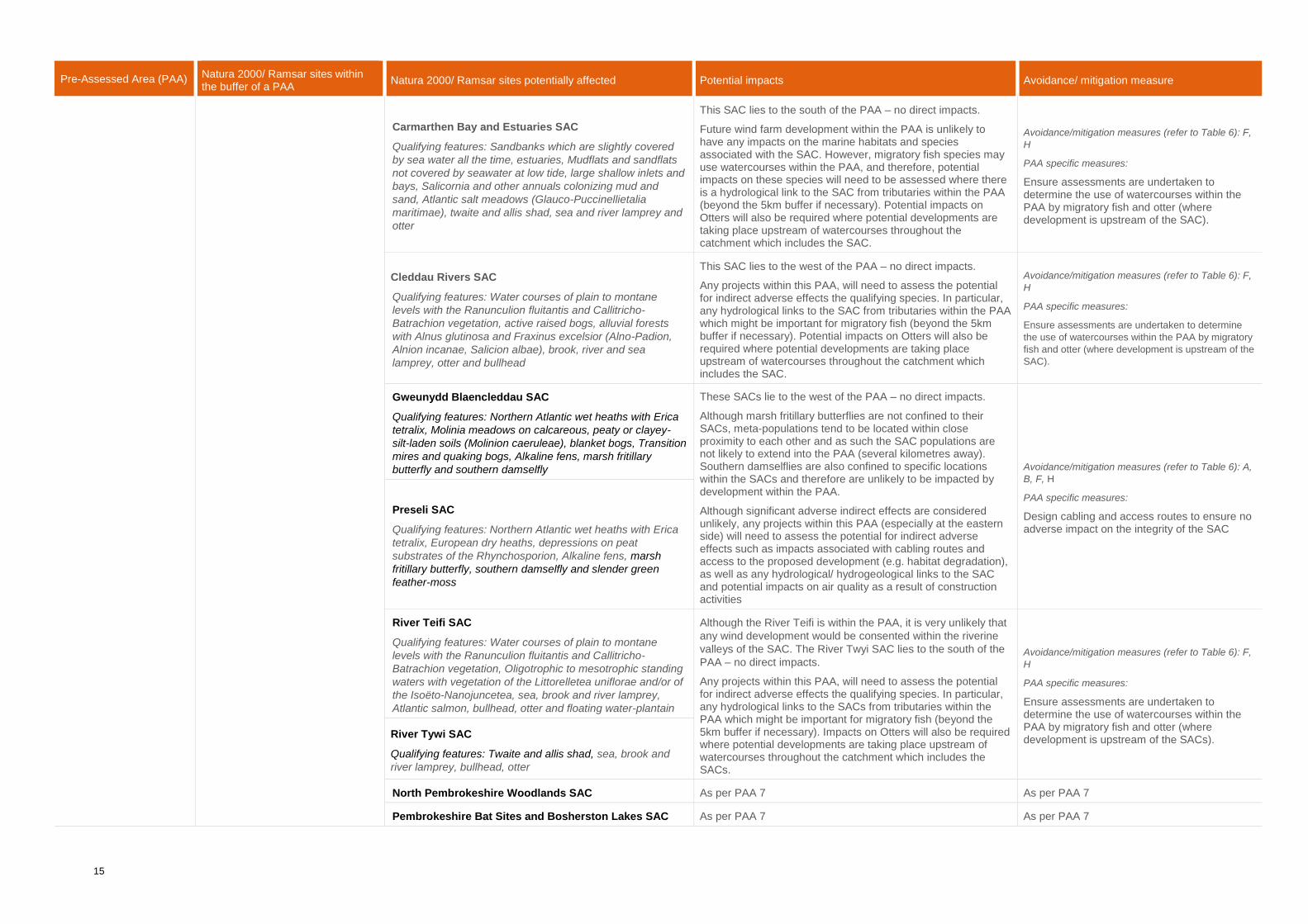
15
Pre-Assessed Area (PAA) Natura 2000/ Ramsar sites within the buffer of a PAA
Natura 2000/ Ramsar sites potentially affected Potential impacts Avoidance/ mitigation measure
Carmarthen Bay and Estuaries SAC
Qualifying features: Sandbanks which are slightly covered
by sea water all the time, estuaries, Mudflats and sandflats
not covered by seawater at low tide, large shallow inlets and
bays, Salicornia and other annuals colonizing mud and
sand, Atlantic salt meadows (Glauco-Puccinellietalia
maritimae), twaite and allis shad, sea and river lamprey and
otter
This SAC lies to the south of the PAA – no direct impacts.
Future wind farm development within the PAA is unlikely to have any impacts on the marine habitats and species associated with the SAC. However, migratory fish species may use watercourses within the PAA, and therefore, potential impacts on these species will need to be assessed where there is a hydrological link to the SAC from tributaries within the PAA (beyond the 5km buffer if necessary). Potential impacts on Otters will also be required where potential developments are taking place upstream of watercourses throughout the catchment which includes the SAC.
Avoidance/mitigation measures (refer to Table 6): F,
H
PAA specific measures:
Ensure assessments are undertaken to determine the use of watercourses within the PAA by migratory fish and otter (where development is upstream of the SAC).
Cleddau Rivers SAC
Qualifying features: Water courses of plain to montane
levels with the Ranunculion fluitantis and Callitricho-
Batrachion vegetation, active raised bogs, alluvial forests
with Alnus glutinosa and Fraxinus excelsior (Alno-Padion,
Alnion incanae, Salicion albae), brook, river and sea
lamprey, otter and bullhead
This SAC lies to the west of the PAA – no direct impacts.
Any projects within this PAA, will need to assess the potential for indirect adverse effects the qualifying species. In particular, any hydrological links to the SAC from tributaries within the PAA which might be important for migratory fish (beyond the 5km buffer if necessary). Potential impacts on Otters will also be required where potential developments are taking place upstream of watercourses throughout the catchment which includes the SAC.
Avoidance/mitigation measures (refer to Table 6): F,
H
PAA specific measures:
Ensure assessments are undertaken to determine
the use of watercourses within the PAA by migratory
fish and otter (where development is upstream of the
SAC).
Gweunydd Blaencleddau SAC
Qualifying features: Northern Atlantic wet heaths with Erica
tetralix, Molinia meadows on calcareous, peaty or clayey-
silt-laden soils (Molinion caeruleae), blanket bogs, Transition
mires and quaking bogs, Alkaline fens, marsh fritillary
butterfly and southern damselfly
These SACs lie to the west of the PAA – no direct impacts.
Although marsh fritillary butterflies are not confined to their SACs, meta-populations tend to be located within close proximity to each other and as such the SAC populations are not likely to extend into the PAA (several kilometres away). Southern damselflies are also confined to specific locations within the SACs and therefore are unlikely to be impacted by development within the PAA.
Although significant adverse indirect effects are considered unlikely, any projects within this PAA (especially at the eastern side) will need to assess the potential for indirect adverse effects such as impacts associated with cabling routes and access to the proposed development (e.g. habitat degradation), as well as any hydrological/ hydrogeological links to the SAC and potential impacts on air quality as a result of construction activities
Avoidance/mitigation measures (refer to Table 6): A,
B, F, H
PAA specific measures:
Design cabling and access routes to ensure no adverse impact on the integrity of the SAC
Preseli SAC
Qualifying features: Northern Atlantic wet heaths with Erica
tetralix, European dry heaths, depressions on peat
substrates of the Rhynchosporion, Alkaline fens, marsh
fritillary butterfly, southern damselfly and slender green
feather-moss
River Teifi SAC
Qualifying features: Water courses of plain to montane
levels with the Ranunculion fluitantis and Callitricho-
Batrachion vegetation, Oligotrophic to mesotrophic standing
waters with vegetation of the Littorelletea uniflorae and/or of
the Isoëto-Nanojuncetea, sea, brook and river lamprey,
Atlantic salmon, bullhead, otter and floating water-plantain
Although the River Teifi is within the PAA, it is very unlikely that
any wind development would be consented within the riverine
valleys of the SAC. The River Twyi SAC lies to the south of the
PAA – no direct impacts.
Any projects within this PAA, will need to assess the potential for indirect adverse effects the qualifying species. In particular, any hydrological links to the SACs from tributaries within the PAA which might be important for migratory fish (beyond the 5km buffer if necessary). Impacts on Otters will also be required where potential developments are taking place upstream of watercourses throughout the catchment which includes the SACs.
Avoidance/mitigation measures (refer to Table 6): F,
H
PAA specific measures:
Ensure assessments are undertaken to determine the use of watercourses within the PAA by migratory fish and otter (where development is upstream of the SACs).
River Tywi SAC
Qualifying features: Twaite and allis shad, sea, brook and
river lamprey, bullhead, otter
North Pembrokeshire Woodlands SAC As per PAA 7 As per PAA 7
Pembrokeshire Bat Sites and Bosherston Lakes SAC As per PAA 7 As per PAA 7
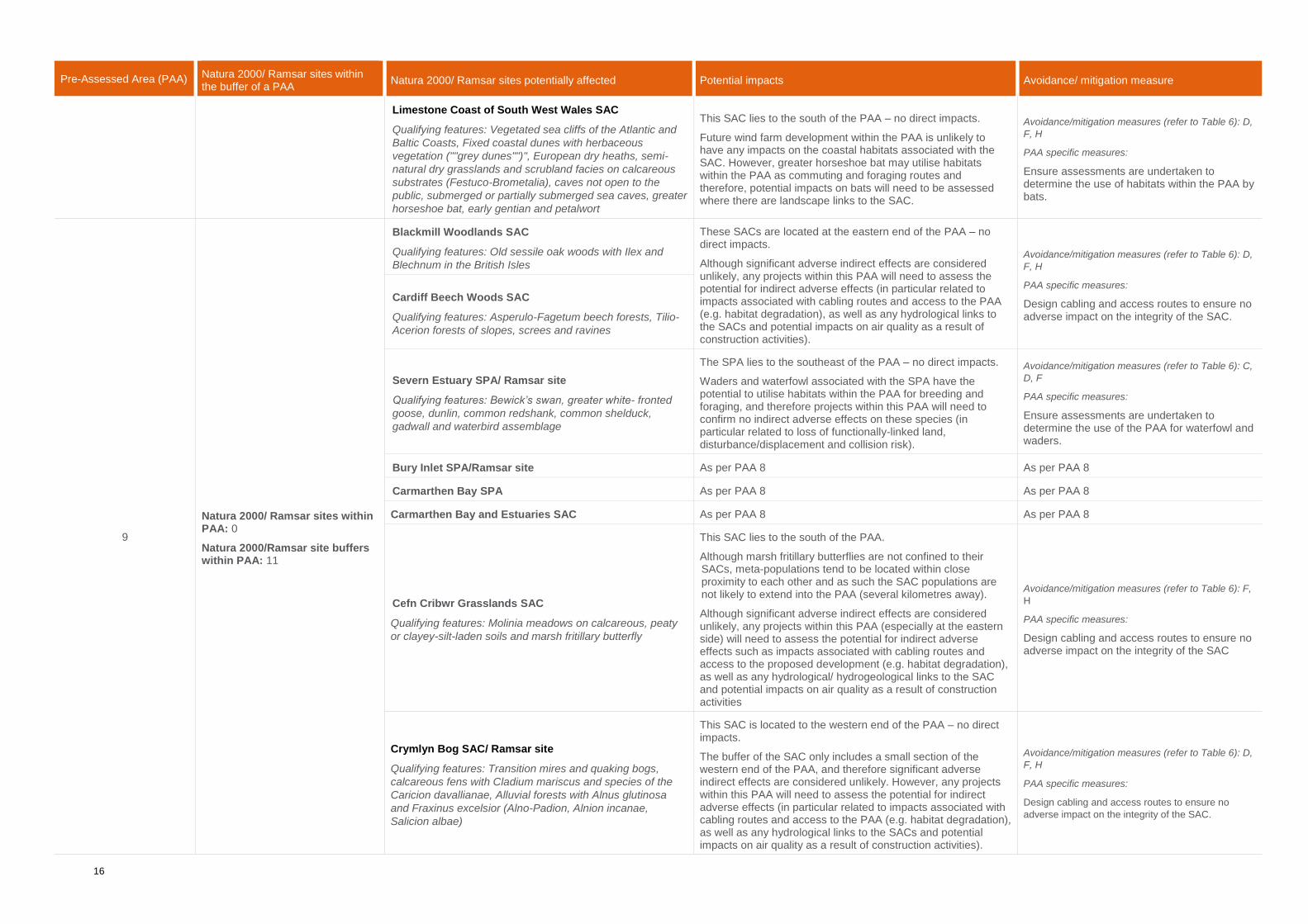
16
Pre-Assessed Area (PAA) Natura 2000/ Ramsar sites within the buffer of a PAA
Natura 2000/ Ramsar sites potentially affected Potential impacts Avoidance/ mitigation measure
Limestone Coast of South West Wales SAC
Qualifying features: Vegetated sea cliffs of the Atlantic and
Baltic Coasts, Fixed coastal dunes with herbaceous
vegetation (""grey dunes"")", European dry heaths, semi-
natural dry grasslands and scrubland facies on calcareous
substrates (Festuco-Brometalia), caves not open to the
public, submerged or partially submerged sea caves, greater
horseshoe bat, early gentian and petalwort
This SAC lies to the south of the PAA – no direct impacts.
Future wind farm development within the PAA is unlikely to have any impacts on the coastal habitats associated with the SAC. However, greater horseshoe bat may utilise habitats within the PAA as commuting and foraging routes and therefore, potential impacts on bats will need to be assessed where there are landscape links to the SAC.
Avoidance/mitigation measures (refer to Table 6): D,
F, H
PAA specific measures:
Ensure assessments are undertaken to determine the use of habitats within the PAA by bats.
9
Natura 2000/ Ramsar sites within PAA: 0
Natura 2000/Ramsar site buffers within PAA: 11
Blackmill Woodlands SAC
Qualifying features: Old sessile oak woods with Ilex and
Blechnum in the British Isles
These SACs are located at the eastern end of the PAA – no direct impacts.
Although significant adverse indirect effects are considered unlikely, any projects within this PAA will need to assess the potential for indirect adverse effects (in particular related to impacts associated with cabling routes and access to the PAA (e.g. habitat degradation), as well as any hydrological links to the SACs and potential impacts on air quality as a result of construction activities).
Avoidance/mitigation measures (refer to Table 6): D,
F, H
PAA specific measures:
Design cabling and access routes to ensure no adverse impact on the integrity of the SAC.
Cardiff Beech Woods SAC
Qualifying features: Asperulo-Fagetum beech forests, Tilio-
Acerion forests of slopes, screes and ravines
Severn Estuary SPA/ Ramsar site
Qualifying features: Bewick’s swan, greater white- fronted
goose, dunlin, common redshank, common shelduck,
gadwall and waterbird assemblage
The SPA lies to the southeast of the PAA – no direct impacts.
Waders and waterfowl associated with the SPA have the potential to utilise habitats within the PAA for breeding and foraging, and therefore projects within this PAA will need to confirm no indirect adverse effects on these species (in particular related to loss of functionally-linked land, disturbance/displacement and collision risk).
Avoidance/mitigation measures (refer to Table 6): C,
D, F
PAA specific measures:
Ensure assessments are undertaken to determine the use of the PAA for waterfowl and waders.
Bury Inlet SPA/Ramsar site As per PAA 8 As per PAA 8
Carmarthen Bay SPA As per PAA 8 As per PAA 8
Carmarthen Bay and Estuaries SAC As per PAA 8 As per PAA 8
Cefn Cribwr Grasslands SAC
Qualifying features: Molinia meadows on calcareous, peaty
or clayey-silt-laden soils and marsh fritillary butterfly
This SAC lies to the south of the PAA.
Although marsh fritillary butterflies are not confined to their SACs, meta-populations tend to be located within close proximity to each other and as such the SAC populations are not likely to extend into the PAA (several kilometres away).
Although significant adverse indirect effects are considered unlikely, any projects within this PAA (especially at the eastern side) will need to assess the potential for indirect adverse effects such as impacts associated with cabling routes and access to the proposed development (e.g. habitat degradation), as well as any hydrological/ hydrogeological links to the SAC and potential impacts on air quality as a result of construction activities
Avoidance/mitigation measures (refer to Table 6): F,
H
PAA specific measures:
Design cabling and access routes to ensure no adverse impact on the integrity of the SAC
Crymlyn Bog SAC/ Ramsar site
Qualifying features: Transition mires and quaking bogs,
calcareous fens with Cladium mariscus and species of the
Caricion davallianae, Alluvial forests with Alnus glutinosa
and Fraxinus excelsior (Alno-Padion, Alnion incanae,
Salicion albae)
This SAC is located to the western end of the PAA – no direct impacts.
The buffer of the SAC only includes a small section of the western end of the PAA, and therefore significant adverse indirect effects are considered unlikely. However, any projects within this PAA will need to assess the potential for indirect adverse effects (in particular related to impacts associated with cabling routes and access to the PAA (e.g. habitat degradation), as well as any hydrological links to the SACs and potential impacts on air quality as a result of construction activities).
Avoidance/mitigation measures (refer to Table 6): D,
F, H
PAA specific measures:
Design cabling and access routes to ensure no
adverse impact on the integrity of the SAC.

17
Pre-Assessed Area (PAA) Natura 2000/ Ramsar sites within the buffer of a PAA
Natura 2000/ Ramsar sites potentially affected Potential impacts Avoidance/ mitigation measure
Limestone Coast of South West Wales SAC As per PAA 8 As per PAA 8
10
Natura 2000/ Ramsar sites within PAA: 0
Natura 2000/Ramsar site buffers within PAA: 6
Blaen Cynon SAC
Qualifying feature: marsh fritillary butterfly
These SACs lie outside of the PAA – no direct impacts.
Although marsh fritillary butterflies are not confined to their SACs, meta-populations tend to be located within close proximity to each other and as such the SAC populations are not likely to extend into the PAA (several kilometres away).
Although significant adverse indirect effects are considered unlikely, any projects within this PAA (especially at the eastern side) will need to assess the potential for indirect adverse effects such as impacts associated with cabling routes and access to the proposed development (e.g. habitat degradation), as well as any hydrological/ hydrogeological links to the SAC and potential impacts on air quality as a result of construction activities.
Avoidance/mitigation measures (refer to Table 6): F,
H
PAA specific measures:
Design cabling and access routes to ensure no adverse impact on the integrity of the SAC
Aberbargoed Grasslands SAC
Qualifying features: Molinia meadows on calcareous, peaty
or clayey-silt-laden soils and marsh fritillary butterfly
Severn Estuary SPA/ Ramsar site As per PAA 9 As per PAA 9
Usk Bat sites SAC
Qualifying features: European dry heaths, degraded raised
bogs still capable of natural regeneration, blanket bogs,
calcareous rocky slopes with chasmophytic vegetation,
caves not open to the public, Tilio-Acerion forests of slopes,
screes and ravines and lesser horseshoe bat
These SACs are located to the north and east of the PAA – no direct impacts.
The buffers of the SACs only reach the western side of the PAA, and therefore significant adverse impacts on qualifying habitats and species are considered unlikely. However, any projects within the western side of the PAA must ensure that potential impacts on commuting and foraging bats are assessed. Impacts associated with cabling routes and access to the PAA (e.g. habitat degradation), as well as any hydrological links to the SACs and potential impacts on air quality as a result of construction activities must also be assessed.
Avoidance/mitigation measures (refer to Table 6): D,
F, H
PAA specific measures:
Design cabling and access routes to ensure no
adverse impact on the integrity of the SAC.
Ensure assessments are undertaken to determine the use of the PAA for bats
Wye Valley and Forest of Dean Bat Sites SAC
Qualifying features: lesser horseshoe bat and greater
horseshoe bat

Arcadis UK
ECHQ, 34 York Way
London N1 9AB
United Kingdom.
T: +44 (0) 20 7812 2000
arcadis.com

!
!
!
!
!
!
8
9
46
3
7
2
1
10
5
Ba ngo r
Newpo rtSwa nsea
Ca rd iff
St Da vid 's
Ab erystwyth
Legend :P re-Assessed Area s
DesignationRa m sa r siteSpec ia l Area o f Co nserva tio nCa nd id a te Spec ia l Area o f Co nserva tio nSpec ia l P ro tec tio n Area
C:\Users\rga 76695\ARCADIS\UA009148 Env Assessm ent o f NDF - Dig_Eng_GIS\MXDs\10012279-ARC-XX-XX-DR-YE-0001 - Overview o f P rio rity Area s fo r So la r a nd W ind Energy a nd Na tura 2000_Ra m sa r sites within W a les.m xd © Co pyright reservedP rint Da te: 03-24-20 16:11:4050m m o n Origina l
Revisio n:Dra wing Num b er:10012279-ARC -XX-XX-DR-YE-0001P 02
Suita b ility Descriptio n:Issued fo r info rm a tio n
Da tum :
Grid :
Dra wn R.MILLMANChec ked L.TURLEYAppro ved D.HOURDSc a le:Origina l Size: A3Suita b ility Co d e: S2
Signed
Signed
Signed
P ro jec t Num b er:
AODOS10012279
Da te24MAR20Da te24MAR20Da te24MAR20
TITLE:
Figure 1: Overview o f P re-Assessed Area s
a nd Na tura 2000/ Ra m sa r sites in W a les
Client
SiteWALES
W ELSH GOVERNMENT
Client
PROJECT:
W ALES NATIONAL DEVELOP MENT FRAMEW ORK – ENVIRONMENTAL ASSESSMENTS
W elsh Go vernm entCa tha ys P a rkCa rd iffCF10 3NQ0300 0604400
Descriptio nDa teRevP 02 First issue RM
Dra wn
LT DH
Chec k Appro v
06/06/19
NOTES:
0 40km
1:900,000
1:900,000
www.arcadis.com
Registered office:Arcadis House34 York Way, London N1 9AB
Coordinating office:5TH Floor,401 Faraday Street,WarringtonWA3 6GA
Co nta ins OS d a ta © Cro wn Co pyright a nd d a ta b a se right 2019
P 02 Fina l Issue RM LT DH24/03/20

L egend:Pre-Assessed Areas
DesignationRamsar S iteCandidate S pecial Area ofConservation (cS AC)S pecial Area ofConservation (S AC)S pecial Protection Area(S PA)
Designation BuffersS AC or cS AC (5km)S AC supporting lesserhorseshoe bat (10km)S AC supporting greaterhorseshoe and/orbarbastelle bat (20km)Ramsar S ite (20km)S PA (20km)S PA S upporting Chough(40k m)
Midland Meres & Mosses - Phase 2 Ramsar
Midland Meres & Mosses - Phase 2 Ramsar
Midland Meres & Mosses - Phase 2 Ramsar
Midland Meres & Mosses - Phase 2 Ramsar
Midland Meres & Mosses - Phase 1 Ramsar
L lyn Tegid Ramsar
L lyn Idwal Ramsar
L iverpool Bay / Bae L erpwl (Wales) S PA
Traeth L afan / L avan S ands, Conway Bay S PA
Y nys S eiriol / Puffin Island S PA
Y Fenai a Bae Conwy / Menai S trait and Conwy Bay S AC
Eryri / S nowdonia S AC
Migneint-Arenig-Dduallt S AC and S PA
Berwyn a Mynyddoedd De Clwyd / Berwyn and S outh Clwyd MountainsS AC and S PA
Rhinog S AC
Berwyn a Mynyddoedd De Clwyd / Berwyn and S outh Clwyd Mountains S AC
Glynllifon S AC
Y T wyni o Abermenai i Aberffraw / Abermenai to Aberffraw Dunes S AC
Coedydd Aber S AC
Morfa Harlech a Morfa Dyffryn S AC
River Dee and Bala L ak e / Afon Dyfrdwy a L lyn Tegid (Wales) S AC
Morfa Harlech a Morfa Dyffryn S AC
Fenn's, Whixall, Bettisfield, Wem and Cadney Mosses (Wales) S AC and Ramsar
Great Orme's Head / Pen y Gogarth S AC
Corsydd Môn a L lyn / Anglesey and L lyn Fens Ramsar, andCorsydd Môn/ Anglesey Fens S AC
Afon Eden - Cors Goch T rawsfynydd S AC
Glannau Mon: Cors heli / Anglesey Coast: S altmarsh S AC Afon Gwyrfai a L lyn
Cwellyn S AC
Y T wyni o Abermenai i Aberffraw / Abermenai to Aberffraw Dunes S AC
Granllyn S AC
Coedydd Derw a S afleoedd Y stlumod Meirion / Meirionnydd Oak woods and Bat S ites S AC
Coedwigoedd Dyffryn Elwy / Elwy Valley Woods S AC
Johnstown Newt S ites S AC
Mwyngloddiau Fforest Gwydir / Gwydyr Forest Mines S AC
River Dee and Bala L ak e / Afon Dyfrdwy a L lyn Tegid (England) S AC
Coedydd Derw a S afleoedd Y stlumod Meirion / Meirionnydd Oak woods and Bat S ites S AC
Tanat and Vyrnwy Bat S ites / S afleoedd Y stlumod Tanat ac Efyrnwy S AC
Tanat and Vyrnwy Bat S ites / S afleoedd Y stlumod T anat ac Efyrnwy S AC
Coedydd Derw a S afleoedd Y stlumod Meirion / Meirionnydd Oak woods and Bat S ites S AC
Alyn Valley Woods / Coedwigoedd Dyffryn Alun S AC
Deeside and Buck ley Newt sites S AC
Coedwigoedd Penrhyn Creuddyn / Creuddyn Peninsula Woods S AC
L lwyn S AC
Glan-traeth S AC
Glannau Mon: Cors heli / Anglesey Coast: S altmarsh S AC
Corsydd Eifionydd / Eifionydd Fens S AC
Halk yn Mountain / Mynydd Helygain S AC
Fenn's, Whixall, Bettisfield, Wem and Cadney Mosses (England) S AC
River Dee and Bala L ak e S AC
Dee Estuary / Aber Dyfrdwy S AC,and T he Dee Estuary S PA and Ramsar
Mersey Narrows & North Wirral Foreshore S PA and Ramsar
Mersey Estuary S PA and Ramsar
2
1
3 33C:\U sers\rga76695\ARCADIS \U A009148 Env Assessment of NDF - Dig_ Eng_ GIS \MX Ds\10012279-ARC-X X -X X -DR-Y E-0002 - Detailed maps of Priority Areas for S olar and Wind Energy and Natura 2000_ Ramsar S ites with site buffers.mxd © Copyright reservedPrint Date: 10-29-20 18:31:4150mm on Original
Revision:Drawing Number:
S uitability Description:Issued for information
Datum:
Grid:
Drawn R.MIL L MANCheck ed L .T U RL EYApproved D.HOU RDS cale:Original S ize: A3S uitability Code: S 2
S igned
S igned
S igned
Project Number:
AODOS10012279
Date29OCT 20Date29OCT 20Date29OCT 20
T IT L E:
Figure 2: Detailed Maps of Pre-Assessed Areas
and Natura 2000 / Ramsar S ites with S ite Buffers
Page 1 of 4
Client
S iteWALES
WEL S H GOVERNMENT
Client
PROJECT:
Welsh GovernmentCathays ParkCardiffCF10 3NQ0300 0604400
DescriptionDateRev Drawn Check Approv
0 15km
1:350,000
1:350,000
www.arcadis.com
Registered office:Arcadis House34 York Way, London N1 9AB
Coordinating office:5TH Floor,401 Faraday Street,WarringtonWA3 6GA
123 4
P01 First Draft RM L T DH06/06/19
WAL ES NAT IONAL DEVEL OPMENT FRAMEWORK – ENVIRONMENTAL AS S ES S MENT S
10012279-ARC -X X -X X -DR-Y E-0002P02
P02 Final Issue RM L T DH24/03/20

Legend:Pre-Assessed Area s
Designa tionRa msa r SiteCa ndida te Specia l Area ofConserva tion (cSAC)Specia l Area ofConserva tion (SAC)Specia l Protection Area(SPA)
Designation BuffersSAC or cSAC (5km)SAC supporting lesserhorseshoe ba t (10km)SAC supporting grea terhorseshoe a nd/orba rba stelle ba t (20km)Ra msa r Site (20km)SPA (20km)SPA Supporting Chough(40km)
M idla nd M eres & M osses - Pha se 1 Ra msa r
M idla nd M eres & M osses - Pha se 2 Ra msa r
M ynydd Epynt SAC
Northern Ca rdiga n Ba y / Gogledd Ba e Ceredigion SPA
M idla nd M eres & M osses - Pha se 1 Ra msa r
Dyfi Estua ry/ Aber Dyfi SPA a nd Cors Fochno a nd Dyfi Ra msa r
Cra ig yr Aderyn (Bird's Rock) SPA
Elenydd SAC a nd Elenydd – M a lla en SPA
Ca da ir Idris SAC
Cwm Doethie - M ynydd M a lla en SAC a nd SPA a nd Elenydd – M a lla en SPA
Elenydd SAC a nd Elenydd – M a lla en SPA
Cors Fochno SAC a nd Cors Fochno a nd Dyfi Ra msa r
River Wye / Afon Gwy (Wa les) SAC
Cors Ca ron SAC a nd Ra msa r
River Wye / Afon Gwy (Engla nd) SAC
M orfa Ha rlech a M orfa Dyffryn SAC
Rhos Goch SAC
Rhos T a lgla s SAC
Grogwynion SAC
Gra nllyn SAC
Drostre Ba nk SAC
M ontgomery Ca na l SAC
Coedydd Derw a Sa fleoedd Y stlumod M eirion / M eirionnydd Oa kwoods a nd Ba t Sites SAC
T a na t a nd V yrnwy Ba t Sites / Sa fleoedd Y stlumod T a na t a c Efyrnwy SAC
T a na t a nd V yrnwy Ba t Sites / Sa fleoedd Y stlumod T a na t a c Efyrnwy SAC
Coetiroedd CwmEla n / Ela n V a lley Woodla nds SAC
Coedydd a Cheuna nt Rheidol / Rheidol Woods a nd Gorge SAC
Coedydd Lla wr-y-glyn SAC
Coed Cwm Einion SAC
T he Stiperstones & T he Hollies SAC
Downton Gorge SAC
T he Stiperstones & T he Hollies SAC
River Clun SAC
4
6
3
8
5
7
C:\U sers\rga 76695\ARCADIS\U A009148 Env Assessment of NDF - Dig_ Eng_ GIS\M XDs\10012279-ARC-XX-XX-DR-Y E-0002 - Deta iled ma ps of Priority Area s for Sola r a nd Wind Energy a nd Na tura 2000_ Ra msa r Sites with site buffers.mxd © Copyright reservedPrint Da te: 10-29-20 18:32:1650mm on Origina l
Revision:Dra wing Number:
Suita bility Description:Issued for informa tion
Da tum:
Grid:
Dra wn R.M ILLM ANChecked L.T U RLEYApproved D.HOU RDSca le:Origina l Size: A3Suita bility Code: S2
Signed
Signed
Signed
Project Number:
AODOS10012279
Da te29OCT 20Da te29OCT 20Da te29OCT 20
T IT LE:
Figure 2: Deta iled M a ps of Pre-Assessed Area s
a nd Na tura 2000 / Ra msa r Sites with Site Buffers
Pa ge 2 of 4
Client
SiteWALES
WELSH GOV ERNM ENT
Client
PROJECT:
Welsh GovernmentCa tha ys Pa rkCa rdiffCF10 3NQ0300 0604400
DescriptionDa teRev Dra wn Check Approv
0 15km
1:350,000
1:350,000
www.arcadis.com
Registered office:Arcadis House34 York Way, London N1 9AB
Coordinating office:5TH Floor,401 Faraday Street,WarringtonWA3 6GA
123 4
P01 First Dra ft RM LT DH06/06/19
WALES NAT IONAL DEV ELOPM ENT FRAM EWORK – ENV IRONM ENT AL ASSESSM ENT S
10012279-ARC -XX-XX-DR-Y E-0002P02
P02 Fina l Issue RM LT DH24/03/20

Legend:Pre-Assessed Area s
Designa tionRa m sa r SiteCa ndida te Specia l Area ofConserva tion (cSAC)Specia l Area ofConserva tion (SAC)Specia l Protection Area(SPA)
Designation BuffersSAC or cSAC (5km )SAC supporting lesserhorseshoe b a t (10km )SAC supporting grea terhorseshoe a nd/orb a rb a stelle b a t (20km )Ra m sa r Site (20km )SPA (20km )SPA Supporting Chough(40km )
Mynydd Epynt SAC
Coedydd N edd a Mellte SAC
W est W a les Ma rine/ Gorllewin Cym ru Forol SAC
Afonydd Cledda u / Cledda u Rivers SAC
Pem b rokeshire Ba t Sites a nd BosherstonLa ke / Sa fleoedd Ystlum Sir Benfro aLlynnoedd Bosherton SAC
Pem b rokeshire Ba t Sites a nd Bosherston La ke / Sa fleoedd Ystlum Sir Benfroa Llynnoedd Bosherton SAC
Crym lyn Bog Ra m sa r, a nd Crym lyn Bog / Cors Crym lyn SAC
Skom er, Skokholm a nd theSea s off Pem b rokeshire/ Sgom er, Sgogwm a Moroedd Penfro SPA Burry Inlet SPA
a nd Ra m sa r
Ca stlem a rtin Coa st SPA
Ra m sey a nd St Da vid's Peninsula Coa st SPA
Ca rdiga n Ba y / Ba e Ceredigion SAC
Ca rm a rthen Ba y a nd Estua ries / Ba e Ca erfyrddin a c Ab eroedd SAC a nd SPA
Elenydd SAC a nd Elenydd – Ma lla en SPA
Preseli SAC
Cwm Doethie - Mynydd Ma lla en SAC a nd SPA a nd Elenydd – Ma lla en SPA
Cors Fochno SAC a nd Cors Fochno a nd Dyfi Ra m sa r
Cors Ca ron SAC a nd Ra m sa r
Afon Teifi / River Teifi SAC
Afon Tywi / River Tywi SAC
Lim estone Coa st of South W est W a les / Arfordir Ca lchfa en De Orllewin Cym ru SAC
Afonydd Cledda u / Cledda u Rivers SAC
St Da vid's / Ty Ddewi SAC
St Da vid's / Ty Ddewi SAC
Rhos Ta lgla s SAC
Bla en Cynon SAC
Grogwynion SAC
Gweunydd Bla encledda u SAC
Rhos Lla wr-cwrt SAC
Ca ea u Mynydd Ma wr SAC
Pem b rokeshire Ba t Sites a nd BosherstonLa ke / Sa fleoedd Ystlum Sir Benfro aLlynnoedd Bosherton SAC
N orth W est Pem b rokeshire Com m ons / Com in GogleddOrllewin Sir Benfro SAC
Yerb eston Tops SAC
N orth Pem b rokeshire W oodla nds / Coedydd Gogledd Sir Benfro SAC
Coedydd a Cheuna nt Rheidol / Rheidol W oods a nd Gorge SAC
Coedydd Lla wr-y-glyn SAC
Coed Cwm Einion SAC
Cernydd Ca rm el SAC
8
6
9
7
C:\U sers\rga 76695\ARCADIS\U A009148 Env Assessm ent of N DF - Dig_ Eng_ GIS\MXDs\10012279-ARC-XX-XX-DR-YE-0002 - Deta iled m a ps of Priority Area s for Sola r a nd W ind Energy a nd N a tura 2000_Ra m sa r Sites with site b uffers.m xd © Copyright reservedPrint Da te: 10-29-20 18:32:5450m m on Origina l
Revision:Dra wing N um b er:
Suita b ility Description:Issued for inform a tion
Da tum :
Grid:
Dra wn R.MILLMANChecked L.TU RLEYApproved D.HOU RDSca le:Origina l Size: A3Suita b ility Code: S2
Signed
Signed
Signed
Project N um b er:
AODOS10012279
Da te29OCT20Da te29OCT20Da te29OCT20
TITLE:
Figure 2: Deta iled Ma ps of Pre-Assessed Area s
a nd N a tura 2000 / Ra m sa r Sites with Site Buffers
Pa ge 3 of 4
Client
SiteWALES
W ELSH GOV ERN MEN T
Client
PROJECT:
W elsh Governm entCa tha ys Pa rkCa rdiffCF10 3N Q0300 0604400
DescriptionDa teRev Dra wn Check Approv
0 15km
1:350,000
1:350,000
www.arcadis.com
Registered office:Arcadis House34 York Way, London N1 9AB
Coordinating office:5TH Floor,401 Faraday Street,WarringtonWA3 6GA
123 4
P01 First Dra ft RM LT DH06/06/19
W ALES N ATION AL DEV ELOPMEN T FRAMEW ORK – EN V IRON MEN TAL ASSESSMEN TS
10012279-ARC -XX-XX-DR-YE-0002P02
P02 Fina l Issue RM LT DH24/03/20

Legend:Pre-Assessed Area s
Designa tionRa m sa r SiteCa ndida te Specia l Area ofConserva tion (cSAC)Specia l Area ofConserva tion (SAC)Specia l Protection Area(SPA)
Designation BuffersSAC or cSAC (5km )SAC supporting lesserhorseshoe b a t (10km )SAC supporting grea terhorseshoe a nd/orb a rb a stelle b a t (20km )Ra m sa r Site (20km )SPA (20km )SPA Supporting Chough(40km )
Gla swelltiroedd Cefn Crib wr / Cefn Crib wr Gra ssla nds SAC
Severn Estua ry Ra m sa r a nd SPA
Mynydd Epynt SAC
Coedydd N edd a Mellte SAC
Crym lyn Bog Ra m sa r, a nd Crym lyn Bog / Cors Crym lyn SAC
Burry Inlet SPAa nd Ra m sa r
Severn Estua ry (Engla nd) SPA, SAC a nd Ra m sa r
Severn Estua ry (W a les) SPA, SAC a nd Ra m sa r
Severn Estua ry / Môr Ha fren SAC
Severn Estua ry (W a les) SAC
Cwm Doethie - Mynydd Ma lla en SAC a nd SPA a nd Elenydd – Ma lla en SPA
Usk Ba t Sites / Sa fleodd Ystlum od W ysg SAC
River Usk / Afon W ysg SAC
Kenfig / Cynffig SAC
Kenfig / Cynffig SAC
River W ye / Afon Gwy (Engla nd) SAC
Afon Tywi / River Tywi SAC
Lla ngorse La ke / Llyn Syfa dda n SAC
River W ye / Afon Gwy SAC
Bla en Cynon SAC
Brecon Bea cons/ Ba nna u Brycheiniog SAC
Bla ckm ill W oodla nds SAC
Ca rdiff Beech W oods SAC
Ab erb a rgoed Gra ssla nds SAC
Suga r Loa f W oodla nds SAC
Lim estone Coa st of South W est W a les / Arfordir Ca lchfa en De Orllewin Cym ru SAC
W ye V a lley W oodla nds / Coetiroedd Dyffryn Gwy SAC
Drostre Ba nk SAC
Ca ea u Mynydd Ma wr SAC
Coed y Cerrig SAC
Cwm Clyda ch W oodla nds / Coedydd Cwm Clyda ch SAC
Dunra ven Ba y SAC
W ye V a lley a ndForest of Dea nBa t Sites / Sa fleoedd Ystlum od DyffrynGwy a Fforest y Ddena (W a les) SAC
Gower Ash W oods / Coedydd Ynn Gŵ yr SAC
Gower Com m ons / Tiroedd Com in Gŵ yr SAC
Cernydd Ca rm el SAC
Cwm Ca dla n SAC
Exm oor Hea ths SAC
Mendip Lim estone Gra ssla nds SAC
N orth Som erset & Mendip Ba ts SAC
Mendip Lim estone Gra ssla nds SAC
Avon Gorge W oodla nds SAC
9
8
10
57
C:\Users\rga 76695\ARCADIS\UA009148 Env Assessm ent of N DF - Dig_ Eng_ GIS\MXDs\10012279-ARC-XX-XX-DR-YE-0002 - Deta iled m a ps of Priority Area s for Sola r a nd W ind Energy a nd N a tura 2000_Ra m sa r Sites with site b uffers.m xd © Copyright reservedPrint Da te: 10-29-20 18:33:3050m m on Origina l
Revision:Dra wing N um b er:
Suita b ility Description:Issued for inform a tion
Da tum :
Grid:
Dra wn R.MILLMANChecked L.TURLEYApproved D.HOURDSca le:Origina l Size: A3Suita b ility Code: S2
Signed
Signed
Signed
Project N um b er:
AODOS10012279
Da te29OCT20Da te29OCT20Da te29OCT20
TITLE:
Figure 2: Deta iled Ma ps of Pre-Assessed Area s
a nd N a tura 2000 / Ra m sa r Sites with Site Buffers
Pa ge 4 of 4
Client
SiteWALES
W ELSH GOV ERN MEN T
Client
PROJECT:
W elsh Governm entCa tha ys Pa rkCa rdiffCF10 3N Q0300 0604400
DescriptionDa teRev Dra wn Check Approv
0 15km
1:350,000
1:350,000
www.arcadis.com
Registered office:Arcadis House34 York Way, London N1 9AB
Coordinating office:5TH Floor,401 Faraday Street,WarringtonWA3 6GA
123 4
P01 First Dra ft RM LT DH06/06/19
W ALES N ATION AL DEV ELOPMEN T FRAMEW ORK – EN V IRON MEN TAL ASSESSMEN TS
10012279-ARC -XX-XX-DR-YE-0002P02
P02 Fina l Issue RM LT DH24/03/20


![P22 USA Manual[1]](https://static.fdocuments.us/doc/165x107/577cc48e1a28aba71199b602/p22-usa-manual1.jpg)