Functionalities & Developments in Sensor...
48
Functionalities & Developments in Sensor Networks Leonard Poveromo, Technology Director Robert P. Silberstein, Tech Fellow Technology Development Northrop Grumman Aerospace Systems Bethpage, NY 1 Presented at the Government-Industry-University Research Roundtable (GUIRR) Meeting February 23, 2010 Approved for Public Release: Northrop Grumman Case 10-0187 Dated 22 Feb 2010
-
Upload
vuongnguyet -
Category
Documents
-
view
224 -
download
1
Transcript of Functionalities & Developments in Sensor...

Functionalities & Developments in Sensor Networks
Leonard Poveromo, Technology Director
Robert P. Silberstein, Tech Fellow
Technology Development
Northrop Grumman Aerospace Systems
Bethpage, NY1
Presented at the
Government-Industry-University
Research Roundtable (GUIRR) Meeting
February 23, 2010
Approved for Public Release:
Northrop Grumman Case 10-0187 Dated 22 Feb 2010

Outline
• Northrop Grumman today
• The people who really did this work
• Sensors for Aircraft: Prognosis and Health Monitoring
• New Ground Sensors: Infrasound
• Emerging Platforms: Unmanned Aerial Vehicles (UAVs)
• New Airborne Sensors: LIDAR
• Air & Space Remote Sensing: Hyperspectral Airborne Tactical Instrument (HATI)
• Back to Earth: Sensor Systems for Homeland Security
• Future Technologies: Wireless Power
• Technology Collaborations / Lessons Learned
2

Northrop Grumman Today
• $34 billion sales in 2008
• $78 billion total backlog
• 120,000 people, 50 states, 25 countries
• Third largest U.S. defense contractor
• Leading capabilities in:
– Systems integration
– C4ISR and battle management
– Information technology and networks
– Defense electronics
– Naval shipbuilding
– Space and missile defense
3
Focus on Performance

Northrop Grumman Today
4
Systems Support
Base and Infrastructure
Support
Range Operations
Maintenance Support
Training and Simulations
Technical and
Operational Support
Live, Virtual and
Constructive Domains
Life Cycle Optimization
Performance Based
Logistics
Modifications, Repair
and Overhaul (MRO)
Supply Chain Management
Lead Support
Integrator (LSI)
Technical Services
Radar Systems
C4ISR
Electronic Warfare
Naval & Marine Systems
Navigation & Guidance
Military Space
Government Systems
Electronic Systems
Large Scale Systems Integration
C4ISR
Unmanned Systems
Airborne Ground Surveillance / C2
Naval BMC2
Global / Theater Strike Systems
Electronic Combat Operations
ISR Satellite Systems
Missile Defense Satellite Systems
MILSATCOM Systems
Environmental & Space Science Satellite Systems
Directed Energy Systems
Strategic Space Systems
Aerospace Systems Shipbuilding
Naval Systems Integrator
Surface Combatants
Expeditionary
Warfare Ships
Auxiliary Ships
Marine Composite
Technology
Coast Guard Cutters
Commercial Ships
Nuclear Aircraft Carriers
Nuclear Submarines
Fleet Maintenance
Aircraft Carrier
Overhaul & Refueling
Command & Control
Systems
Network Communications
Intelligence, Surveillance &
Reconnaissance Systems
Enterprise Systems
and Security
IT/Network Outsourcing
Intelligence
Federal, State/Local
& Commercial
Homeland Security
& Health
Information Systems
Five Operating Sectors

Transformation of Northrop Grumman
Northrop GrummanNorthrop
Grumman
Westinghouse Defence Electronics
Vought
Logicon
INRI
DPC
Navia
FDC
Aerojet
Fibersense
Xontech
Cal Mic
Teledyne Ryan
Comptek
Sterling Software
Litton
Newport News
TRW
7/0312/0211/0110/014/0110/006/004/007/996/994/999/985/973/968/945/94
Long-range precision strike
Persistent ISR
Maritime superiority
Networked BM / C4
Space superiority
Once “merely” a combat aircraft company, now a systems integrator
with a broad portfolio supporting defense transformation
5

Outline
• Northrop Grumman today
• The people who really did this work
• Sensors for Aircraft: Prognosis and Health Monitoring
• New Ground Sensors: Infrasound
• Emerging Platforms: Unmanned Aerial Vehicles (UAVs)
• New Airborne Sensors: LIDAR
• Air & Space Remote Sensing: Hyperspectral Airborne Tactical Instrument (HATI)
• Back to Earth: Sensor Systems for Homeland Security
• Future Technologies: Wireless Power
• Technology Collaborations / Lessons Learned
6

7
Sensors for AircraftPrognosis
From: “Sensor Systems for Real-time Crack Monitoring and Structural Prognosis During Full Scale Fatigue Test of an Aircraft
Wing Panel,” ASNT 17th Annual Research Symposium, 2008,
By R. Silberstein, R. J. Christ, Jr., S. J. Engel, J. Madsen, J. Nardiello, J. Papazian, J. Payne, B. Pember (Northrop Grumman Aerospace
Systems); and contributors from GA Tech, JENTEK Sensors Inc., U. of PA, Direct Measurements Inc., & Oceana Sensor Technologies;
And from: “Prognostics Health Management – An Engineering Perspective,” Prognostics Health Management Conference,
September 2009
By Stephen J. [email protected]
Northrop Grumman Aerospace Systems

Structural Integrity Prognosis System (SIPS)
• Combine knowledge of fatigue processes, current state, and history of an aircraft
• Develop models, sensors, and reasoning systems
• Increase asset availability and reduce cost without increasing risk
• DARPA funded program
8
Reasoning &
Prediction
Physics-based Models
Sensor Systems
Software System

Overall Goals for Sensor Systems
• Detect earliest incipient material damage
• Utilize real-time data for model calibration and validation
• Exploit correlated multi-sensor data for improved measurement sensitivity and model applicability
• Develop techniques to optimize the selection and placement of sensors for different applications
• Apply sensor systems in full-scale fatigue test for model calibration and verification
• Demonstrate sensor systems in long-term and real-time application for SIPS

Sensor Placement on Wing Panel

Initial Prediction Based on Multi-Scale FatigueModels and Anticipated Usage

Prediction Updated By Measured Usage &State Awareness Information

DARPA/NGC Structural Integrity Prognosis System (SIPS)

Novel Ground Sensors:Infrasound
14
From:
“Infrasound Sensor System Detection of Atlas V Rocket Launch,” Northrop Grumman Technology Review Journal,
Spring/Summer 2009.
By Eric A. Skowbo*, David C. Muh,
and Kelley A. Fanto
Northrop Grumman Aerospace Systems

Power Spectral Density of Three Rocket Launches
16
Atlas V Liftoff

Infrasound Propagation – Near and Far Field
18
Michael Isherwood
Senior Analyst, NG Analysis Center
September 2009
Vision to Reality
Northrop Grumman’s support to
AF Unmanned Systems Vision

Emerging Platforms: UAVs
19
From:
“Vision to Reality,” Northrop Grumman’s Support to Air Force Unmanned System Vision,” Air Force Association
Convention, Sept. 2009.
By Michael Isherwood
Northrop Grumman Analysis Center

Why Unmanned in the Air?
• Unmanned Systems are game changers • Multi-payload/multi-mission• Flexible/reconfigurable• Revolutionary capability / cost
• Reduced Risk to Warfighters• Insensitivity to Anti-Access /
Denial Strategies
• Smaller Force Structure, Smaller Ops / Maintenance / Training Costs
• Integrates / leverages existing force structure• Operational and Political Advantage
• Greater Endurance• Greater Survivability • Addresses Broad Spectrum
of Conflict
• Unsurpassed Persistence and Autonomy
20
Versatile
Efficient
Effective
Less Risk
Less Cost
Collaborative

Unmanned Air SystemsIncreasing Effectiveness of the Joint Team

Unmanned Air SystemsIncreasing Effectiveness of the Joint Team
Extending Communications Throughout the Force

Emerging Opportunities
• Battlefield Communications
• Missile Defense

Airborne LIDAR
24
From:
“New Remote Sensing Concepts to Advance Future Mission Capabilities,”
SPIE Conference, San Diego, August 2009.
By Brian K. Baldauf*, Chris Bracikowski, Chung Wong, and Jennifer Logan
Northrop Grumman Aerospace Systems

Instrument Requirements of the Future
25
Mission Orbit EO Sensor RF Sensor Comment
SMAP NASA LEO SS RADAR JPL in house soil moisture mission
ICESat II NASA LEO NSS LIDAR Ice sheet; QuickICE gap filler from ICESAT
CLARREO NASA/NOAA LEO Pre Spectro/Radiometer Absolute spectrally resolved .4 – 100 m
DESDynI NASA LEO SS LIDAR RADAR Deformation, Ecosystem Structure and Ice
HyspIRI NASA LEO SS Spectro/Radiometer Land surface .4 – 2.5 m
ASCENDS NASA LEO SS LIDAR Multi freq for CO2
SWOT NASA LEO SS RADARs Ka, C for ocean, lake, river water levels
GEO-CAPE NASA GEO Spectro/Radiometer Atmo gas, ocean color
ACE NASA LEO SS LIDAR Doppler RADAR Aerosols and clouds ocean color biochem
LIST NASA LEO SS LIDAR Land surface for landslides, water runoff
PATH NASA GEO MMW Spectro Temp and Moisture soundings
GRACE-II NAA LEO SS LIDAR or wave Gravity fields for large-scale water movement
SCLP NASA LEO SS Spectro/Radiometer RADARs K, Ka / Ku, X bands
GACM NASA LEO SS Spectro/Radiometer wave limb sounder
O3 transport
3D-Winds Demo NASA LEO SS LIDAR Tropo winds
Lidar Mission
HSI and/or Radiometer Mission
Ladar/Lidar, HSI, and Radiometers Cover 80% of Earth Science Missions for This Decade
Current initiatives

LADAR Capabilities at NGAS
26
LADAR research engineering team members:
Jamie Barter Christopher Bracikowski William CottingameMiguel Figueroa Donald Henderson Jennifer LoganRavi Narasimhan Susan Rico Barry StarkMichael Waterman Chung M. Wong
Modeling&
Phenomenology
Hardware Design&
Build
Data Processing Future LADAR Missions
• LxDAR Code Set• Matlab based tool kit
• ASC Flash 3D Camera• Eye-safe 1550 nm laser• 3 Flight Campaigns in 2008
• Geometric Corrections• In-Track and Cross-Track Stitching• Geolocation
• Single Photon Systems• Scanning System for higher coverage rate• Higher Altitude
Performance Models
Environmental Conditions:
Atmosphere, Background, Turbulence, Geolocation
Radiometric Models
Propagation Models
System Parameters & Target Characteristics
LIDAR/LADAR Models
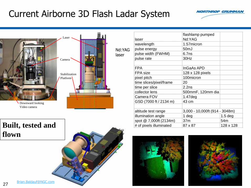
Current Airborne 3D Flash Ladar System
27
Built, tested and
flown
Nd:YAGlaser
laser
flashlamp pumped
Nd:YAG
wavelength 1.57micron
pulse energy 50mJ
pulse width (FWHM) 6.7ns
pulse rate 30Hz
FPA InGaAs APD
FPA size 128 x 128 pixels
pixel pitch 100micron
time slices/pixel/frame 20
time per slice 2.2ns
collector lens 500mmF, 120mm dia
Camera FOV 1.47deg
GSD (7000 ft / 2134 m) 43 cm
altitude test range 3,000 - 10,000ft (914 - 3048m)
illumination angle 1 deg 1.5 deg
spot @ 7,000ft (2134m) 37m 54m
# of pixels illuminated 87 x 87 128 x 128
Laser
Camera
Stabilization
Platform
Downward looking
Video camera

Developing Future Instrument Capabilities for NASA Global Hawk
• NASA’s latest airborne platform
• Bridges the Gap between space and earth based sensors
• Can simultaneously support numerous instruments such as LIDAR systems
• Collection of data in remote and inaccessible locations
• Developing concepts for integrated HIS and LIDAR systems
– 1000-1500 lb payload capacity
– 11000 nm range
– 65kft alt
– 343 knots TAS
– 30+ hour endurance
• Three ACTD aircraft transferred from USAF to NASA
• Aircraft Based at NASA Dryden, Edwards Air Force Base, CA

Air & SpaceRemote Sensing
29
From:
“The Hyperspectral Airborne Tactical Instrument (HATI): a Low-cost Compact Airborne Hyperspectral Imager,”
SPIE Conference, San Diego, August 2009.
By Stephanie Sandor-Leahy*, Brian Baldauf, Mark Hemlinger, Miguel Figueroa,
Sveinn Thordarson
Northrop Grumman Aerospace Systems

NGAS Sensor Products & Technologies
30
Hyp
ers
pec
tral
Ra
dio
me
tric
Acti
ve
Sen
sin
gC
om
po
ne
nts
Hyperion/EO-1VNIR/SWIR SpaceTRWIS-Series
VNIR/SWIR Airborne
CERESUV to Far IRERBE UV to Far IR
HSI Processor
LWHISLWIR Airborne
Cal/VerificationFacilities
EVEREST End-End Modeling
VSHCAHigh Alt UAV HSI
Cryocoolers
NGST VISPIPolarimeter
Deployable Optics
Solid State Lasers
Geolite Radiometer
Phenomenology
LNA’s &Receivers
KOMPSAT
OSMI
3D TerrainMapper
LXDARModeling
Fiber Lasers
Space Qual
Lidar/LadarTest Bed
60 W CAPSSL
Mid-IR OPO
100 W LARRE
Lewis HSIVNIR/SWIR Space
HATI VNIR/SWIR
CERES FM5/6UV to Far IR
1990 20102000

Hyperspectral Airborne Tactical Instrument (HATI) Overview
• Multiple airborne campaign and data collects, 2007/2008
• Compact airborne hyperspectral imager designed to fly on a variety of platforms and to be integrated with other sensors in NGAS’s instrument suite
– NGAS Long Wave Hyperspectral Imaging Spectrometer (LWHIS)
– NGAS 3D flash LADAR system
• Push broom sensor gathers information in the 400 nm to 1700 nm wavelength range
• Mounted on COTS aerial photography stabilization platform
• Wide variety of earth observing missions:
– Geological/natural resource surveying, vegetation (re-growth, invasive species,…)
– Forestry, urban, ocean color, HABs
• Future initiatives: upgrades to expand the short wave infrared (SWIR) range and capabilities to facilitate near-autonomous high-altitude operation
31
Piper Navajo
Sample HATI Data over Calibration Site –June 2008
32
RGB Image, Enhanced
100 200 300 400 500 600 700 800
100
200
300
400
500
600
700
800
900
1000
RGB Image, Enhanced
50 100 150 200 250
20
40
60
80
100
120
140
160
180
200
RGB Image, Enhanced
10 20 30 40 50 60 70 80
10
20
30
40
50
60
70
60 Hz (~1m GSD) High Resolution HATI Image Over Santa
Margarita Ecological Reserve Calibration Site

Mark Helmlinger (NGAS) with field spectrometer and Lee Johnson (NASA Ames) document the lush growth along the Santa Margarita River (ground verification)

Project Overview
34
Montecito Fire, - hyperspectralOrchard, - hyperspectral & LadarJasper Ridge Biological Preserve,
- hyperspectral & Ladar
Urban area in San Mateo County, -
hyperspectral & Ladar
San Francisco and Monterey Bay,
- hyperspectral
• 2008 - November hyperspectral and Ladar data collection
– Rapid 2008 execution - 2 month modification, second HSI camera added, integration and collect
– Several hundred Gbytes of data acquired
– substantial ground truth data collected at each site
• 2009 - Data Processing for calibration and orthorectification, and data fusion

Future Plans: Integrating HATI on NASA Global Hawk
• Two ACTD aircraft transferred from USAF
• Aircraft Based at NASA Dryden, Edwards AFB CA
• Equal Partnership with Northrop Grumman shared expenses and operations
• First flight planned in August 2009
• New Plug-and-Play Payload Interfaces
35
• 116 ft wingspan• 1500 lb payload capacity• 11000 nm range• 65kft alt
•343 knots TAS• 30+ hour endurance• 700 lbs per side POD payload

Sensor Systems for Homeland Security
36
From:
“Impact of Nanotechnology”
And
“Homeland Security, Defense and Northrop Grumman”
By Dr.Ronald G. Pirich
Northrop Grumman Aerospace Systems

Chemical & Biological Sensor Detection Systems and Technologies
37
Passive Standoff Chemical Detection
X X X X X X X X X XX X X X X X X X X XX X X X X X X X X XB FIELD
· ··· · X X X X X X X X X X
X X X X X X X X X XX X X X X X X X X X
· ··· ·
Next-Generation Miniature Chem/Bio Sensor
Sensor Fusion and Target Recognition
Demonstration Unit
Radar Detection of Suspicious Release
Mobile Chem/Bio Detection
Computer Aided Dispatch for Emergency Response
Automated Bio Detector

WMD Sensor Detection & Prediction –Northrop Grumman & University Collaboration
38
Northrop Grumman’s MCAD Detects Chemical Agent Concentration & Spatial Extent (MCAD
Source Term)
Stony Brook University’s LBM Model Uses MCAD Source
Term & Meteorological Conditions to Accurately Predict Plume’s Evolution
(Concentration, Areas Affected)

Intelligent Synthesized Sensor & Network Systems Integration

Future Technologies:Wireless Power
40
From:
“Northrop Grumman Technology Development -Overview,”
Livingston Nanotechnology Conference, Dec. 2008
By Leonard Poveromo
Northrop Grumman Aerospace Systems

Wireless Power Applications
• Ground Applications
– Military bases – power/communication to remote sites
– Temporary ship-to-shore power/communication
– Temporary power grid infrastructure
– Temporary communications (populated with comm. modules)
– Temporary power generation (populated with flexible solar cells)
– Emergency response/humanitarian operations
– Park Service /Dept of Interior
• Space Applications
– Space debris/attack protection
– Satellite to satellite power transmission
– Individual space power system
– Lunar site-to-site power transmission

History: Space-Based Radar, Roller Shade Array
42
Reversible Mast Assembly
Pictures of the 8‘x20' Grumman
roller shade microwave lens
assembly in test. It was being
prepared for flight before the
Challenger shuttle loss caused a
cancellation.
New development would create
modular transmitter version to tile
a large structure.Video
Transmit / Receive
Modules with Individual
T/R Antennas

Individual Space Power System (ISPS)
• Less vulnerable to attack
• Safe, renewable power
• 1/16 cell phone exposure
• Economically justifiable to DoD
• Reduces logistics tail
• Humanitarian/commercial apps
• Demo area expandable globally
43
MicrowaveExciter
Solar Array
Microwave Beam
MULTIPLE BEAMS
Low Power Beam Control Transmitter
Microwave Lens Beam Amplifier & Controller Solar
Array
Fabric Embedded RectennasScalable
Initial 0.1 Watt to single soldierInitial 3.6 MegaWatt to power a brigade
All Weather PowerDay or Night
Can Follow Troop Movements
ISPS SATELLITE

44
Conclusions

What’s Next in Technology?
• 18th and 19th century chemistry gave us the energetic materials of World War I
• 19th and 20th century physics gave us nuclear weapons
• What happens when 21st century computing power, “bio,” “nano,” and photonics converge?
• Will adversaries weaponize...?
– Virological and bacteriological systems
– Ground-based directed energy
– Space disruption
– Electromagnetic (rail guns, pulse)
– Unbreakable encryption
– Energy strategies
45

Technology Collaborations / Lessons Learned
• Customers
– Identify key customers whose technology roadmaps align with NGAS strategic technologies for CRAD collaboration
– DARPA, ONR, AFRL, NIMA, Lincoln Labs, Classified
• Sectors
– Identify strategic mutual interests for technology collaboration via cross sector exchanges, NGC Technology database
– All Northrop Grumman sectors
• Suppliers
– Identify key suppliers with unique developed products/capabilities or subject matter experts
• Universities/Laboratories
– Identify key universities/laboratories pursuing 6.1, 6.2
in unique technology areas
46

Questions?
47
Presented at the
Government-Industry-UniversityResearch Roundtable (GUIRR) Meeting
February 23, 2010
Leonard PoveromoTechnology [email protected]
Robert P. SilbersteinTech [email protected]
Northrop Grumman Aerospace SystemsBethpage, NY
1
Leonard PoveromoTechnology Director
Robert P. SilbersteinTech Fellow
Technology DevelopmentNorthrop Grumman Aerospace Systems
Bethpage, NY
Functionalities and
Developments in Sensor
Networks
Presented at the
Government-Industry-University
Research Roundtable (GUIRR) Meeting
February 23, 2010

48