Fuel Spill and Fire Rapid Environmental Emergency Assessment
36
Fuel Spill and Fire Rapid Environmental Emergency Assessment Mukuru-Sinai slum, Nairobi Kenya October 2011
Transcript of Fuel Spill and Fire Rapid Environmental Emergency Assessment
Fuel Spill and Fire Rapid Environmental Emergency Assessment
Mukuru-Sinai slum, Nairobi Kenya October 2011

Published in Switzerland, 2011 by the Joint UNEP/OCHA Environment Unit Copyright © 2011 Joint UNEP/OCHA Environment Unit This publication may be reproduced in whole or in part and in any form for educational or not-for-profit purposes without special permission from the copyright holder, provided acknowledgement is made of the source. Joint UNEP/OCHA Environment Unit Palais des Nations CH-1211 Geneva 10 Switzerland http://www.unocha.org/unep Report Editor: Sandra Besson and Pascal Merland (Veolia Proprete - Waste Force), Shanna McClain and Rene Nijenhuis, Joint UNEP/OCHA Environment Unit Cover photo: Julius Mwelu, IRIN. Battling fires in post-election violence in Nairobi’s Mathare slum. N.B. this is not the picture of the actual slum fire reported in this assessment.

3
Table of Contents Table of Contents……………………………………………………………………………… 3 Executive summary……………………………………………………………………………. 4 List of abbreviations/glossary…………………………………………………………………. 5 1 Introduction……………………………………………………………………………….6 2 Assessment……………………………………………………………………………….. 9 3 Conclusions & recommendations………………………………………………………...18 3.1 Conclusions……………………………………………………………………………….18 3.2 Priority Recommendations………………………………………………………………..18 3.3 Long-Term and Non-Site Specific Recommendations………………………...…………19 Annex I List of Photographic references, 13 October 2011…………………………………...20 Annex II Extract from the newspaper Daily Nation, 12 October 2011………...……………...25 Annex III National Environment Management Authority Report, September 2011…….….....27 Annex IV KPC Press Statement, 12 September 2011…………………………………………34

4
EXECUTIVE SUMMARY On 12 September 2011, international media sources reported a major fuel pipeline explosion and fire in the Mukuru-Sinai slum of Nairobi, Kenya. Over 100 people were burnt to death, while an equal amount of people were hospitalized with serious burn wounds. On 23 September 2011, an official request for environmental emergency response services was made by the Kenyan Ministry of Environment and Mineral Resources (MEMR) through the United Nations Resident Coordinator (UNRC). The United Nations Office for the Coordination of Humanitarian Affairs (OCHA) and the United Nations Environment Programme (UNEP), through their Joint UNEP/OCHA Environment Unit, subsequently compiled an expert team to undertake a rapid environmental emergency assessment. The scope of the mission was to provide scientific information on the extent and nature of pollution and to assist the decision-making and priority-setting by the authorities and other actors for follow-up activities on the affected site. The mission took place from 9 to 16 October 2011. The main conclusion of the mission was that the fire was not caused by a pipeline explosion as reported initially in (international) media, but by an industrial accident that caused a large amount of unleaded petrol to enter a storm water drainage system. A further conclusion was that a repetition of a similar type of accident is considered as highly likely. The area where the accident took place is affected by pre-existing, chronic pollution and therefore no immediate clean-up action is needed for the remaining residues of the accident. There is no immediate threat to the drinking water supply as a result of the accident. The mission established that there is a clear indication of other uncontrolled industrial effluents being released into the storm water drainage system and the Ngong River. Detailed recommendations have been provided in the report detailing the immediate measures to take in order to prevent a re-occurrence of a similar type of accident. The competent authorities are urged to implement these measures without delay. In addition, recommendations have been made to improve the preparedness for environmental emergencies both at the national level and at the local level, in particular through the implementation of UNEP’s programme on Awareness and Preparedness at the Local Level (APELL).
Undamaged zone before the explosion: 20 November 2010 Damaged zone after the explosion: 22 September 2011

5
List of acronyms and glossary of terms APELL JEU KPC MEMR NEMA OCHA UNEP UNITAR UNOSAT UNRC
Awareness and Preparedness for Emergencies at Local Level Joint UNEP/OCHA Environment Unit Kenya Pipeline Company Ministry of Environment and Mineral Resources National Environmental Management Authority Office for the Coordination of Humanitarian Affairs United Nations Environment Programme United Nations Institute for Training and Research United Nations Satellite Applications Programme United Nations Resident Coordinator

6
1. Introduction FUEL EXPLOSION AND FIRE On 12 September 2011, international media sources reported a major fuel pipeline explosion and fire in the Mukuru-Sinai slum of Nairobi, Kenya. Over 100 people were killed, while an equal amount of people were hospitalized with serious burn wounds. Based on an analysis carried out by UNOSAT1, using imagery of the situation before and after the explosion and fire, an estimated area of 10 600m had been seriously affected by the explosion. A further estimated 57 dwellings located in the area had been totally destroyed and 20 had been seriously damaged. The UNOSAT report also indicated that the Ngong River, downstream of the explosion site, appeared to be affected by the release of a large amount of petroleum products.
The satellite image on the left shows the industrial area of Lunga Lunga (in yellow) including a site of the Kenya Pipeline Company, the suspected pipeline (in green) and the affected area (in red adjacent to the Ngong River). Image date: 22 September 2011 – UNITAR/UNOSAT – DigitalGlobe
Upon learning of the emergency OCHA and UNEP, through its Joint UNEP/OCHA Environment Unit (JEU), offered immediate technical support to the national authorities. On 23 September 2011, an official request for environmental emergency response services was made by the Kenyan Ministry of Environment and Mineral Resources (MEMR) through the United Nations Resident Coordinator (UNRC). MISSION SCOPE The JEU subsequently compiled an expert team and agreed with the authorities that the mission would provide scientific information on the extent and nature of pollution to assist the decision-making and priority-setting by the authorities and other actors for follow-up activities on the affected site. As such, it would not look into any liability-related issues of the accident, nor be involved directly in clean-up activities. 1 http://unosat-maps.web.cern.ch/unosat-maps/KE/FR20110913KEN/UNOSAT_KEN_FR2011-Nairobi-Report_v1.pdf

7
The mission would focus on identifying the presence and concentrations of hydrocarbons in soil and surface water and provide recommendations for the mitigation measures; taking into consideration the means available locally. A sampling strategy will be deployed on the field in order to estimate the nature and the extent of the pollution. Specific objectives include: on site sampling and/or analysis to determine the nature and extent of the pollution; assess the impact on environmentally sensitive areas and/or drinking/ground water
supply/resources; recommendations to protect drinking water resources; provide recommendations for mitigation/remediation measures; support the dissemination of results. The mission took place from 9 to 16 October 2011. The mission team was composed of the following four experts: Professor BARY Abdouraman
Programme Officer-Chemicals And Waste Focal Point for Military Environmental Agreements – United Nations Environmental Programme (UNEP)
DOVEIL Laurent, generalist expert and team leader Veolia Propreté –Waste Force
LICARI Antoine, specialist expert (chemist) Veolia Propreté –Waste Force
PAILLER Delphine, generalist expert Veolia Propreté –Waste Force
L.DOVEIL / A.BARY / A.LICARI / D.PAILLER EQUIPMENT The following pieces of specialized equipment had been prepared and shipped to assist the expert team in the implementation of the mission terms of reference: Portable analyser enabling identification and quantification of Volatile Organic Compounds
(VOC) in air, water, and soils. This equipment provides gas chromatography/mass spectrometry, and is specially adapted for the detection of hydrocarbon leaks and organic pollution identification;

8
Total Petroleum Hydrocarbon Test Kit;
pH determination by colorimetric tape. LIMITATIONS Not all equipment was cleared in time to provide the anticipated support during the mission. Therefore the team reviewed their strategy and with the help of the Total Petroleum Hydrocarbon Test Kit most of the mission objectives could be achieved.
As a result, the possible pollution by other organic pollutants that may be present in the soils and river were not determined. A broader overview of the pre-existing environmental pollution is therefore not included in this report. However, a set of samples are being kept by UNEP for possible further analysis.
Total Petroleum Hydrocarbon Test Kit

9
2. Assessment
The field observations and assessments were undertaken in two steps: A first overall reconnaissance visit was made on 11 October 2011. This enabled the experts
to comprehend the layout of the affected site and its surroundings in order to make an evaluation of the residual environmental impact and to build a sampling strategy adapted to the situation in the field;
A second site-visit was made on 13 October 2011, to take water and soil measurements and samples and collect supporting visuals (GPS data, photos, videos) for the correct understanding and interpretation of the collected data.
SITE OBSERVATIONS The first reconnaissance visit on 11 October 2011 clearly highlighted that at the impacted site a number of pre-existing environmental problems existed: Suspected pollution of the river system upstream (large amounts of solid waste, water
polluted with suspended matter, suspected presence of industrial pollution); An outlet into the Ngong River of all or part of the storm drainage system coming from the
industrial area; Discharge of waste water from the slum dwellings into the river; The presence of a household waste landfill (5 hectares) located less than 200 meters from
the affected disaster site, on the opposite side of the Ngong river, allowing the dispersion of leachates and biogas into the environment;
Use of the river to clean plastic residues collected from the landfill for recycling.
The affected area had been entirely cleared before the first field visit took place and only a few remnants, such as the floors of the destroyed dwellings and burned vegetation, were still visible.
Damage Zone after the explosion Image date: 22 September 2011 - UNITAR/UNOSAT - DigitalGlobe
N
50 m
Overview of Ngong river and the household
waste landfill

10
The primary affected site is centred on the outlet of a storm water drainage system situated approximately 15 meters from the Ngong River (marked red in the picture below). The outlet runs into an open gutter which flows into the Ngong River. The site visit also allowed the identification of a second area affected by the fire, further downstream of the Ngong River. The primary and secondary site have been visualised on the satellite imagery below. The distance between the two sites is approximately 80 meters.
Image date: 22 September 2011 - UNITAR/UNOSAT - DigitalGlobe
REDEFINITION OF THE CRISIS SITUATION Based on the information available to the team before the departure, the understanding was that an explosion of a pipeline had occurred. However, it was determined that the actual chain of events was quite different. The press release issued by the Kenya Pipeline Company (KPC) on the 12th September 2011 accident and a Control Audit Report of the National Environmental Management Authority (NEMA) indicated that an accidental leak of petroleum products from the KPC deposit facility, located in the industrial area of Lunga Lunga, southeast of Nairobi, had occurred. Both the audit report and the press release are annexed to this report.
N
20 m

11
Photography of the KPC petroleum deposit facility - www.kpc.co.ke The KPC deposit facility is the terminal point of the Nairobi-Mombasa pipeline and the departure point of pipelines towards Western Kenya. According to KPC staff interviewed, construction works had recently been conducted on the site in order to connect the Nairobi-Eldoret pipeline to the main Nairobi-Mombasa pipeline, when a leak accidentally occurred in the by-pass located between the pipelines. As a result, it was reported that an estimated 18 000 litres of unleaded gasoline had been released. An indeterminate portion of the fuel reached the storm water drainage system in this area of the KPC petroleum deposit facility. The storm water drainage system is not connected to the oil/water separator on the KPC site. Notably, the KPC underground storm water drainage system, composed of a concrete culvert network, is connected, outside the deposit facility, to the underground storm water draining system of the City of Nairobi.
Photography of connection to KPC storm water draining system to Nairobi City storm water drainage system
According to the KPC press release, as soon as the leak had been detected, KPC stopped the supply of oil in the Nairobi-Mombasa pipeline and took immediate mitigation measures. Nevertheless, part of the fuel had already reached the city’s storm water drainage system. Located at one kilometre downstream of the leaking area, the city’s storm water drainage system washed out in the Ngong River, by a 15 meter long open ditch, located in the middle of the Mukuru-Sinai slum. The main hazards linked to unleaded petrol justifying the flammable or explosion risk include: extreme flammability (ignition temperature < -40°c); product vapors are heavier than air which can lead to vapor intrusion through soil and water
contamination and possibly cause illness; friction linked to the outflow of the product can create electrostatic charges capable of
producing sparks;
KPC storm water drainage system and flow direction
Nairobi city storm water drainage system and flow direction

12
unleaded gasoline is potentially carcinogenic, and it is recommended not to be exposed to this product for a long time or regularly.
View of the outlet of the storm water drainage network in the slum
Regarding the human, material and environmental damages which followed, the most probable scenario that took place at the day of the accident seems to be as follows: At the open outlet of the city’s storm water drainage system, extremely flammable vapors formed on the surface of the hydrocarbon spill and created an explosive atmosphere in the slum and the surrounding dwellings. The flammable vapor cloud was dispersed following the flow direction of the petrol spill in the Ngong River.
In these conditions, any spark caused by metal contact, a discarded cigarette, or an open fire in a dwelling could have caused the ignition of petrol fumes present in the atmosphere. The ignition could have taken place at different places due to the dispersion of the vapor cloud from the ditch to the river, as well as the movement of burned people and animals.

13
SAMPLING AND ANALYSIS The aerial photography below shows the location of GPS data-collected waypoints on 13 October 2011, focused on the two main areas affected by the fire.
Aerial photography of GPS waypoints data – Campaign on the 13th of October 2011
The references of the field survey are listed in the following table:
GPS waypoints
N°
Description
Results from Explosimeter
measurements Photos N° Samples for
analysis
100 Ending point storm water draining system - Sinaï Slum (cf point A) 0 1813 Water (PE4)
Soil (PS4)
101 Overview south bank of the river (landfill side) 0 1822, 1823,
1824
102 Switch of direction – upstream river 0 1826, 1829, 1830, 1831
Water (PE1) Soil (PS1)
103 East Edge – islet (landfill side) 0 1832, 1833 104 West Edge front islet (landfill side) 0 1837
105 West Edge –accident triangle 0 1839, 1841 Water (PE2) Soil (PS2)
106 West Edge – front islet (accident side) 0 1842
107 Release point –ditch storm water draining system 0 1843, 1845,
1846
108 East Edge – accident triangle 0 1850 109 East Edge front islet (accident side) 0 1851
110 Switch of direction – downstream river 0 1854 Water (PE3) Soil (PS3)
111 Manhole on waste water network 0 1859 112 Burying point piped network 0 113 North Edge – accident triangle 0 1861, 1862
114 Release from KPC network towards municipal storm water draining system 0 1869, 1870 Water (PE5)
A list of photographic references is available in the Annexes.
N
15 m

14
Based on the field observations described above, representative measurements and samples of soil and water were taken at four separate points at the affected sites. During the entire field visit, the portable explosimeter did not detect any explosive conditions. The analysis of soil samples focused on the possible presence of residual pollution of unleaded petrol. The analysis shows that this pollutant was present in all collected soil samples, ranging from 64 to 264 parts per million (ppm), with a significant increase of petrol in the soil from upstream to downstream in the affected area (following the river flow). This means that the area surrounding the affected site was already polluted with hydrocarbons prior to the accident. The pre-existing chronic hydrocarbon pollution upstream from the main point of the disaster (GPS point N°105 in the picture below), and the analysis results (hydrocarbon content below 500 ppm of total petroleum hydrocarbons (TPH) in all samples) shows that the disaster had no significant additional impact on the already polluted soil in this area; where soil samples with more than 500 ppm require remediation efforts as established by the European Union2. A rapid pH measure was conducted on water samplings with strips of pH paper. The results highlight that collected water in the river has a good homogeneity with a neutral pH of 7. However, water samplings in the terminal point of the municipal storm water drainage system show a high pH (basic) of 10. This result clearly indicates that there are other substances than rainwater run-off being released in the storm water drainage network.
Aerial overview of sampling locations
2 http://environment-agency.gov.uk/research/planning/33714.aspx
N
15 m

15
The analysis results can be summarized as follows:
GPS waypoints Water Soil
Unleaded Gasoline Presence Concentration 100 pH = 10 Yes 64 ppm 105 pH = 7 Yes 118 ppm 102 pH = 7 Yes 158 ppm 110 pH = 7 Yes 264 ppm
In addition to the high pH value measured, a number of subsequent observations support the suspicion that substances other than rain water are being released through the storm water drainage system. Possible observations to consider are: A significant volume flow was observed through a manhole of the storm water drain
located in the industrial area during the field campaign on 11 October during dry weather conditions;
Witness of accident victims in an article of the newspaper « Daily Nation » published on 12 October 2011 (cf. Annex 2): « …Something was different about the fuel leak that caused the explosion. People use sponges to soak up the spillage but that day everyone had a jerrycan. »;
Extract from the KPC press release (cf. Annex 4) indicating: « It has come to our attention that some members of the public are in possession of the spilled product ».
These effluents could not only affect the health of the local population (health risk due to contact with the river water, chemical reactions linked to a mixture of incompatible products which could create toxic fumes and fire hazard), but also affect the environment. Due to the missing equipment, it could not be verified which substances were being released. IMPACT ON SURFACE WATER MANAGEMENT During the second field visit on 13 October, construction works were observed on the outlet of the storm water drainage system, connecting it to the municipal waste water system (GPS waypoint N°111 and see pictures below).
before and during construction Although the exact reasons for this construction work could not be verified on-site, it should be noted that if this is intended to avoid the collection of potential hydrocarbon releases in the storm water drainage system by the slum inhabitants, there will be limitations to achieving this, because:
The outlet of the storm water drainage system before (left) and during (right) the alterations

16
In case of newly released inflammatory products in the storm water drainage system, the hydrocarbon spill would be dispersed in the waste water network, releasing flammable vapors in the inspection hole (especially in the manhole identified by GPS waypoint N°111) and the explosive conditions in the slum would still be present;
The municipal waste water network runs into one of the waste water treatment plants of Nairobi. However, as waste water treatment plants of the city are exclusively equipped for the treatment of domestic effluents, the risk of the treatment facility malfunctioning due to the existence of possible industrial releases could be realized;
Due to the small diameter of the two connected networks (storm water draining system in Ø 800 mm and the municipal waste water network in Ø 300 mm) high hydraulic pressures could destroy the current construction works under way, causing a possible leak at the connection point and further risks of pollution.
One of the most obvious potential sources of pollution of the storm water drainage system, which could cause a similar type of accident with grave human and environmental consequences, was observed at a loading bay and parking for tank vehicles. Tank vehicles, which can contain up to 30,000 liters of petrol, are parked on the sidewalk, without any specific precautions. The parking areas are not equipped in case of accidental leak nor is there any regard or enforcement of basic safety regulations such as a ban on smoking or the use of potential heat sources. As no retention basins exist to contain a potential leak, or the polluted water from simple washing of the trucks, any spilled petrol will penetrate the soil or, if in large enough quantities, flow into the storm water drainage system.
Aerial overview of the tank vehicles parked in the industrial area of Lunga Lunga
N

17
IMPACT ON DRINKING WATER RESOURCES The information collected and the observations made on the field do not indicate, a priori, an immediate risk for drinking water supplies of Nairobi inhabitants. Drinking water is supplied by a network of dams and reservoirs. Regarding the Mukuru-Sinaï slum, lifting or pumping wells have not been observed in the visited areas. According to the information collected in the field, the water of the slum inhabitants is supplied by informal connections to the supply network of the Municipality of Nairobi. A hydrogeological study was not readily available during the time of the mission. This study would have allowed for the review of the presence and directional flow of underground water directly vertical to the impacted area and to the city.
Overview of parking and washing of tank vehicles

18
3. Conclusions & recommendations Based on the observations, interviews and measurements taken in the field, the following conclusions and recommendations can be made. 3.1 CONCLUSIONS Residual pollution resulting from the 12 September 2011 accident with unleaded petrol has been measured at the affected site. However, the levels of pollution are not considered significant in view of the pre-existing and chronic background pollution found to be present in the soil samples measured upstream. Due to the levels of pollution falling below the threshold level of 500 ppm, a cleanup operation of the soils in the affected area would thus, not be not justified. It is reasonable to assume that industrial effluents are being released into the storm water drainage system. The nature of these releases has not been established as part of this mission, but they can possibly pose a direct health risk to the population, a risk to the environment and a risk of further explosion/fumes. The probability of a new accident occurring with potentially similar human and/or environmental consequences is considered to be very likely. 3.2 PRIORITY RECOMMENDATIONS Based on the above, the expert team makes the following recommendations to be implemented with utmost urgency. The immediate recommendations focus on the following three issues: Detailed environmental assessment of the pollution of the Ngong River, upstream and
downstream of the storm water drainage system release; Mapping of the entire storm water drainage system and sewage system in the Lunga Lunga
industrial area; Prevention of industrial releases into the municipal storm water drainage system. DETAILED ENVIRONMENTAL ASSESSMENT OF THE NGONG RIVER A detailed environmental assessment should be undertaken of the Ngong River to establish the levels and types of pollution in the river, upstream and downstream of the storm water drainage system outlet. As a first step, samples should be analysed according to international standards for organic and mineral compounds. The analysis results would allow classification of the chemical and potentially hazardous compounds present in the water, either by nature or by quantity, and to reliably define the sources of the pollution. MAPPING OF STORM WATER DRAINING AND SANITATION SYSTEMS No overview of the storm water drainage system was available at the time of the mission. If no such map exists, the following techniques could be used to map the underground networks of the Lunga-Lunga industrial area: Fluorescent flow tests; GPS locations of manholes for different stretches, combined with flow directions TV inspection of the networks with associated tracing.

19
Once this mapping is completed it will be possible to identify the locations where the release can potentially diffuse into the Sinai slum. It will be important to carefully distinguish the nature of the releases, such as whether it is a storm water drainage release or a sewage water release. PREVENTION OF INDUSTRIAL RELEASES INTO THE MUNICIPAL STORM WATER DRAINAGE SYSTEM It is important to distinguish between two types of industrial releases in the municipal storm water drainage system: regular industrial release and accidental industrial releases. In both cases, the following recommendation directly refers to the 12th of September accident: Equip where necessary, the connections to the storm water draining system with an
oil/water separator of correct dimensions to contain the downstream dispersion of pollutants. These separators require regular maintenance.
For regular releases, unannounced and/or periodical inspections can be undertaken, including the manholes of the storm water drainage system located near the industrial sites (in dry weather conditions). Suspected industrial releases should be sampled for analysis. Each industrial facility should have an evaluation of the impact of a possible release of
effluents in the storm water drainage system. Such an evaluation would include an accident scenario with associated health and environmental impacts and should be carried out in partnership with the operators of the sites. A prioritization of the identified risks of the entire industrial area should also form part of this (see also recommendations on UNEP, APELL on next page).
3.3 LONG-TERM AND NON-SITE SPECIFIC RECOMMENDATIONS In order to improve the water quality of the Ngong River, similar environmental assessments and mitigation measures as described above should be replicated at points where anthropogenic effluents enter the river system. Considering the multiple suspected pollutants in the surface water and the possible migration of hydrocarbons towards the groundwater table, the undertaking of an assessment of the groundwater to determine possible pollution thereof is recommended. The groundwater assessment should be comprised of the following steps: Hydro-geological study aiming to qualify the groundwater table under the accident site and
on a similar area of the other bank of the Ngong River (on the same side as the landfill); Drilling bore holes in order to define the flow direction of the groundwater table; Placement of at least three piezometers for periodical follow-up for the evolution of
underground water quality. These meters should be located (1) upstream of the impacted area (ideally upstream the industrial area), (2) near the Ngong River (between the impacted area and the landfill), and (3) upstream from the landfill;
Develop and follow a sampling program, in order to follow the relevant parameters (of which organic pollution should be part of), by upstream/downstream measurements.
The household waste landfill across from the accident site falls outside the scope of this mission. Nevertheless, regarding its immediate proximity and the uncontrolled release of leachates and biogas into the environment (and especially towards the Ngong River), it is

20
recommended to consider the main environmental impacts of this landfill when implementing the site specific recommendations. As such, due consideration should be given to determine and control the quality and quantity of leachates into the Ngong River and groundwater. The situation of a densely populated area adjacent to an industrial site is most likely not limited to the Lunga Lunga industrial area and the Mukuru-Sinai slum. A national level hazard inventory of industries using hazardous materials should be undertaken as part of the national disaster management and/or contingency planning process. Environmental emergencies should be fully integrated into the national humanitarian response system. UNEP together with the private sector has developed a proven process that prepares for potentially serious accidents and which creates a coordinated emergency response capability for all aspects of industrial disasters. Awareness and Preparedness for Emergencies at the Local Level (APELL) brings economic and public relations benefits over and above ensuring public safety and environmental quality. This process provides a tool for preventing accidents and minimizing their impact through the assistance of decision makers and technical personnel in increasing community awareness and preparing coordinated response plans involving governments, industry and the local community. It should be considered to apply the APELL process in the Lunga Lunga/Mukuru-Sinai area, and possibly at other sides. Available at http://www.unep.fr/scp/sp/

21
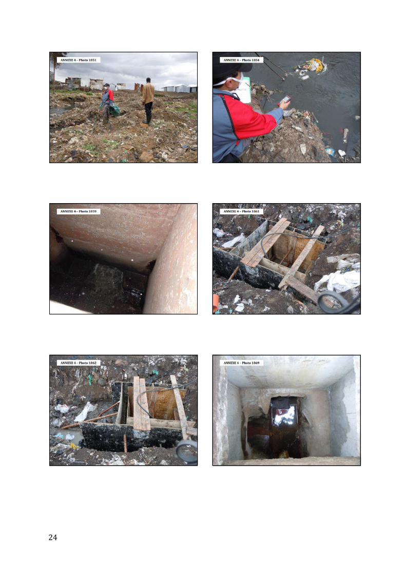
ANNEX I: LIST OF PHOTOGRAPHIC REFERENCES FROM THE SECOND FIELD VISIT, 13 OCTOBER 2011

22

23
24

25

26
ANNEX II: EXTRACT FROM THE DAILY NATION NEWSPAPER, 12 October 2011, “SINAI ONE MONTH ON”

27

28
ANNEX III: NATIONAL ENVIRONMENT MANAGEMENT AUTHORITY REPORT
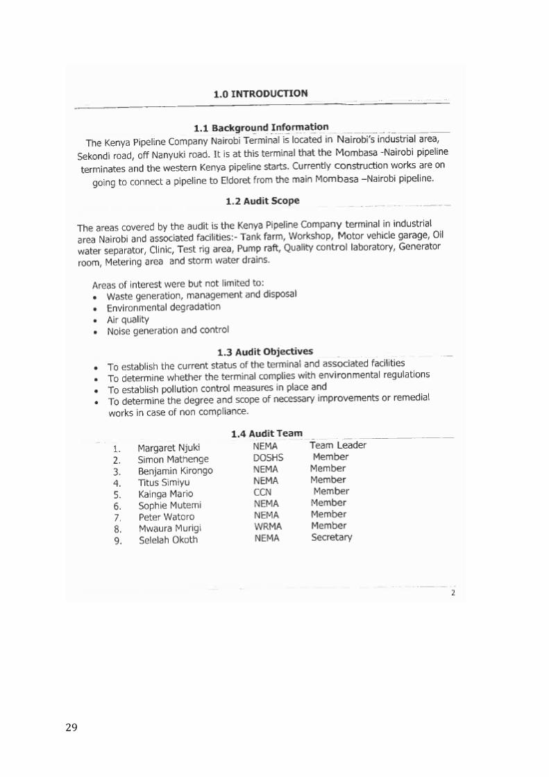
29

30
31

32

33

34

35
ANNEX IV: KPC PRESS STATEMENT, 12 SEPTEMBER 2011

36