
Fuel Management and Erosion
22
USDA Forest Service RMRS-GTR-231. 2010. 79 CHAPTER 5. Fuel Management and Erosion Pete R. Robichaud, Rocky Mountain Research Station, USDA Forest Service, Moscow, ID Lee H. MacDonald, Watershed Science Program, Colorado State University, Fort Collins, CO Randy B. Foltz, Rocky Mountain Research Station, USDA Forest Service, Moscow, ID Introduction As the severity and extent of wildfires increase, efforts to reduce forest densities on public lands by thinning and prescribed burning also are increasing. The intentional sup- pression of fires in the western United States, beginning in the early 1900s, has altered the extent, frequency, and severity of wildfires (Agee 1993; Baker 1993). Reductions in timber harvest and in grazing, when combined with the suppression of wildfires, have resulted in higher fuel loadings, which increase the risk of high severity wildfires (Norris 1990). Changes in the fire regime may also cause vegetation changes, such as increases in tree stand density, spread of noxious weeds, and tree invasion into grass- lands (Arno and Gruell 1986). Any increase in high severity wildfires is of considerable concern because of the potential damage to life and property and the adverse effects on water quality, fish habitat, and other aquatic resources (Keane and others 2002). The goal of most fuel management efforts is to reduce the potential adverse effects due to increased frequency of large, high severity wildfires. Although forest managers attempt to minimize impacts of fuel management activities, the removal of vegetation and the alteration of soil properties due to logging, road building, and prescribed fire may affect site conditions, forest runoff, and water quality (Lindeburgh 1990; Lousier 1990; Rice and Datzman 1981; Tiedemann and others 1979). Undisturbed forests are an important source of the clean water that is necessary for ecosystem health as well as urban and agricultural uses. Forest vegetation and litter promote high infiltration rates and low levels of overland flow and protect the soil from rainsplash and erosive forces due to overland flow (Baker 1990; Robichaud 2000). This results in high quality runoff, low erosion rates, and low sediment yields (Binkley and Brown 1993; Buckhouse and Gaither 1982; MacDonald and Stednick 2003). Reported sediment yields from undisturbed forests in the western United States are typically around 0.003 t ac -1 (0.007 Mg ha -1 ) (Mg = 10 6 grams or 1 metric tonne), but values up to 11 t ac -1 (25 Mg ha -1 ) have been measured (Stednick 2000). Sediment yields are dependent on several factors such as climate, topography, soil type, vegetation, historic land use, and the dominant erosion processes (Stednick 2000). By altering infiltration rates, evapotranspiration rates, and disturbing the soil, forest management activities— including road construction, timber harvesting, site preparation, and fuel reduction— can greatly increase overland flow rates and sediment yields. This chapter reviews the effects of roads, thinning operations, and prescribed fire on runoff and erosion, and discusses the current understanding of the cumulative effects of Cumulave Watershed Effects of Fuel Management in the Western United States
Transcript of Fuel Management and Erosion

USDA Forest Service RMRS-GTR-231. 2010. 79
chApter 5.
Fuel Management and Erosion
Pete R. Robichaud, Rocky Mountain Research Station, USDA Forest Service, Moscow, ID
Lee H. MacDonald, Watershed Science Program, Colorado State University, Fort Collins, CO
Randy B. Foltz, Rocky Mountain Research Station, USDA Forest Service, Moscow, ID
IntroductionAs the severity and extent of wildfires increase, efforts to reduce forest densities on
public lands by thinning and prescribed burning also are increasing. The intentional sup-pression of fires in the western United States, beginning in the early 1900s, has altered the extent, frequency, and severity of wildfires (Agee 1993; Baker 1993). Reductions in timber harvest and in grazing, when combined with the suppression of wildfires, have resulted in higher fuel loadings, which increase the risk of high severity wildfires (Norris 1990). Changes in the fire regime may also cause vegetation changes, such as increases in tree stand density, spread of noxious weeds, and tree invasion into grass-lands (Arno and Gruell 1986). Any increase in high severity wildfires is of considerable concern because of the potential damage to life and property and the adverse effects on water quality, fish habitat, and other aquatic resources (Keane and others 2002). The goal of most fuel management efforts is to reduce the potential adverse effects due to increased frequency of large, high severity wildfires. Although forest managers attempt to minimize impacts of fuel management activities, the removal of vegetation and the alteration of soil properties due to logging, road building, and prescribed fire may affect site conditions, forest runoff, and water quality (Lindeburgh 1990; Lousier 1990; Rice and Datzman 1981; Tiedemann and others 1979).
Undisturbed forests are an important source of the clean water that is necessary for ecosystem health as well as urban and agricultural uses. Forest vegetation and litter promote high infiltration rates and low levels of overland flow and protect the soil from rainsplash and erosive forces due to overland flow (Baker 1990; Robichaud 2000). This results in high quality runoff, low erosion rates, and low sediment yields (Binkley and Brown 1993; Buckhouse and Gaither 1982; MacDonald and Stednick 2003). Reported sediment yields from undisturbed forests in the western United States are typically around 0.003 t ac-1 (0.007 Mg ha-1) (Mg = 106 grams or 1 metric tonne), but values up to 11 t ac-1 (25 Mg ha-1) have been measured (Stednick 2000). Sediment yields are dependent on several factors such as climate, topography, soil type, vegetation, historic land use, and the dominant erosion processes (Stednick 2000). By altering infiltration rates, evapotranspiration rates, and disturbing the soil, forest management activities— including road construction, timber harvesting, site preparation, and fuel reduction—can greatly increase overland flow rates and sediment yields.
This chapter reviews the effects of roads, thinning operations, and prescribed fire on runoff and erosion, and discusses the current understanding of the cumulative effects of
Cumulative Watershed Effects of Fuel Management in the Western United States

80 USDA Forest Service RMRS-GTR-231. 2010.
these activities on water yield, stream flow, and sediment production at the watershed scale. Much of the relevant research has been done at the plot, or occasionally, the hill-slope scale; however, simply “scaling up” or summing the measured small-scale effects will not necessarily provide an accurate estimation of cumulative watershed effects. In addition, relatively few studies have specifically measured the effects of fuel treatments. Thus, this review includes the results from selective timber harvest studies and low se-verity wildfires, as these studies provide the data needed to estimate the likely effects of different fuel treatment activities. The effects of roads, forest thinning, and prescribed fire on runoff and erosion in the western United States are discussed in separate sec-tions, even though many fuel management programs will require more than one of these activities. The final section discusses the cumulative effects of these fuel management activities, as well as the potential cumulative effects at the watershed scale.
Effects of Forest Roads for Fuel ManagementRoads are ubiquitous in the forest environment. Forest roads are needed for economi-
cal removal of forest products, resource management activities, recreation activities, and public access. From a fuel management perspective, forest roads are needed to con-duct prescribed burning, thinning, and timber harvest operations. The majority of forest roads are unpaved. These compacted road surfaces typically have very low infiltration rates and, as a result, generate large amounts of surface runoff (Luce and Cundy 1992; Reid and Dunne 1984; Vincent 1979). Road surfaces are subjected to rainsplash, and the combination of rainsplash with large amounts of surface runoff results in surface erosion rates that are several orders of magnitude higher than the adjacent undisturbed forest (for example, MacDonald and others 2004; Megahan 1978). Research has con-sistently shown that roads have the greatest effect on erosion of all practices associated with forest management (Megahan and King 2004). Although other forest manage-ment activities usually occur on a larger proportion of the landscape, the erosion rates on roads are the dominant source of sediment in most managed forests (Brown and MacDonald 2005).
Forest road effects have been summarized in Forest Roads: A Synthesis of Scientific Information (Gucinski and others 2001) and Roads Analysis: Informing Decisions About Managing the National Forest Transportation System (Bisson and others 1999). The former compiles current knowledge about the direct physical and ecological effects, indirect and landscape-scale effects, and direct and indirect socio-economic effects of forest roads. Roads Analysis is a six-step planning tool designed to evaluate, mostly in qualitative terms, the ecological, social, and economic effects of existing and future for-est roads. Thus, only relevant studies addressing runoff and sediment yield from roads used for fuel management are presented.
Effects of Forest Roads on Runoff and Erosion
Effects of roads as structuresInfiltration rates in undisturbed forests are typically at least 1.5 to 3 in h-1 (40 to
80 mm h-1) (Robichaud 2000); therefore, few rainstorms or snowmelt events initiate infiltration-excess (Horton) overland flow. In comparison, road components (cut slope, ditch, running surface, and fill slope) have infiltration rates from 0.004 to 0.4 in h-1 (0.1 to 10 mm h-1), which frequently results in overland flow.
The flow paths of overland flow depend on road geometry. On insloped roads, water from the cut slope flows to the ditch and reaches the forest floor via a culvert (fig. 1A), and runoff from the fill slope flows onto the forest floor. On outsloped roads, runoff from the cut slope and running surface flows across the road and fill slope to the adjacent for-est floor (fig. 1B). The benefits of insloped roads include:
1. the ability to control and direct the concentrated flow;
ChaPTer 5. fuel managemenT and erosion

USDA Forest Service RMRS-GTR-231. 2010. 81
P.r. roBiChaud, l.h. maCdonald, r.B. folTz CumulaTive WaTershed effeCTs of fuel managemenT in The WesTern uniTed sTaTes
2. the absence of concentrated flow on the structurally weaker fill slope; and 3. lower risk that a vehicle will slide off the road in wet conditions.
The benefits of outsloped roads include:
1. less concentrated flow because surface runoff immediately drains off the road prism; 2. less undercutting of the hillslope because flow is not concentrated parallel to the
hillslope; 3. fewer culverts are used, reducing culvert maintenance and road damage due to
culvert failure; and 4. reduced delivery of concentrated flow.
Proper road maintenance is needed to attain the benefits of both insloped and outsloped roads. In particular, if wheel ruts form on the running surface or grading results in a small berm at the edge of the road surface, runoff will be concentrated on the running surface (fig. 1C). On insloped roads, concentrated road surface runoff may result in bypassed relief culverts, while on outsloped roads, road runoff will drain off the road prism as concentrated flow rather than dispersed sheet flow (Foltz 2003).
Effects of road useRunoff can detach and transport the fine material available on unpaved road sur-
faces. Without vehicle traffic, the sediment concentration in the road runoff decreases over time. However, vehicle traffic, especially heavy trucks, can crush road surface aggregate material and this generates more fine particles that are available for transport by runoff. In addition, the pressure of vehicular tires on saturated road aggregate can force fine particles from below the surface to move to the surface (Bilby and others 1989; Truebe and Evans 1994). In western Oregon, 20 percent of the material finer than 0.003 in (0.075 mm) diameter was eroded over 3 months from a structurally weak road aggregate that was subjected to 26 in (660 mm) of rainfall and 884 logging truck trips (Foltz and Truebe 1995). The authors concluded that truck traffic generated 11 tons of fines per acre of road surface (24 Mg ha-1).
Road erosion rates generally increase with increased traffic, and heavy vehicles tend to cause more erosion than light vehicles (Megahan 1974; Reid and Dunne 1984). Higher use also is associated with more frequent maintenance operations, and grading
Figure 1. Typical forest road prism structure. (A) insloped road with ditch; (B) outsloped road; and (C) road with wheel ruts.

82 USDA Forest Service RMRS-GTR-231. 2010.
increases the amount of available sediment and road erosion rates (Luce and Black 1999). Bilby and others (1989) measured sediment production from two forest roads in southwestern Washington—one mainline road with high traffic and one secondary road with little traffic. Routine maintenance was performed on the mainline road once or twice per week while maintenance was done on the secondary road every 7 to 8 weeks. Sediment production over the 23-week study period was 2.5 times greater for the main-line road (46 t mi-1, 26 Mg km-1) than for the secondary road (18 t mi-1, 10 Mg km-1).
Many techniques used to estimate road sediment production assume factors that influ-ence it (for example, rainfall, traffic, roadway material, etc.) are additive. For example, in the Washington Forest Practices (1995) analysis method, sediment production esti-mates are independently modified by factors for traffic and surface material. However, a recent study in western Oregon found little difference in sediment production between road plots that were subjected to traffic and those that were recently graded but had no traffic (Luce and Black 2001). They concluded that applying adjustment factors inde-pendently overestimated the effect of traffic on new roads or recently maintained roads.
Mitigation of road use effectsThe impacts of traffic on sediment production can be mitigated through the use of
Best Management Practices (BMP) such as slash filter windrows, rocking the road sur-face, and ditch armouring (Burroughs and King 1989; Megahan and others 1992). On the Eldorado National Forest, rocking reduced road sediment production by approxi-mately one order of magnitude (MacDonald and others 2004). A comparison of 20 road surface aggregates showed that sediment production was directly proportional to the amount of aggregate finer than 0.24 in (0.60 mm) (Foltz and Truebe 2003). However, some fines are needed to prevent the aggregate from rolling under vehicle tires and being ‘kicked’ off the road by traffic. More recent BMPs include practices such as re-ducing truck tire inflation pressures, which reduces the contact pressure on the road surface and traffic-induced sediment production. For example, Foltz and Elliot (1996) found that reducing tire pressure from 90 psi (620 kPa) (highway pressure) to 70 psi (480 kPa) reduced sediment production by 45 percent, and a further reduction to 50 psi (350 kPa) reduced sediment production by 80 percent.
Use of low-use, brushed-in roads for fuel management activitiesOn many miles of low-use forest roads, vegetation has been allowed to grow on the
running surface to reduce road-generated sediment. Although no formal assessment has been done, observations of these “brushed-in” roads indicate that sediment production rates are a tenth of the rates for bare roads with traffic. Forest access for fuel manage-ment activities will likely require that these brushed-in roads be reopened by scraping the vegetation off the running surface and, to some degree, the cut and fill slopes. In many cases, the increased road availability and use for fuel management activities will also attract additional recreational traffic, including off-highway vehicles (OHV). While OHVs, particularly all-terrain vehicles (ATVs), are lighter than trucks or automobiles, they loosen and move road surface material laterally making it available for subsequent transport (Iverson 1980).
Road Obliteration Effects on Runoff and Erosion
The type and frequency of fuel management activities must be factored into forest transportation plans, as this may affect both road construction and road removal. The re-moval of forest roads from service, or “decommissioning,” is usually accomplished by blocking the road entrance and restoring the road prism to a more natural state (USDA Forest Service 2000). Road obliteration is the most complete form of decommissioning, and this involves ripping the road surface, removing culverts, re-establishing stream channels, reshaping the roadbed to match the hillside contour, and planting vegetation.
Like road construction, road obliteration typically causes a spike in sediment produc-tion that decreases rapidly after the activity ends. Brown (2002) measured the sediment
ChaPTer 5. fuel managemenT and erosion
USDA Forest Service RMRS-GTR-231. 2010. 83
generated during road obliteration at five stream crossings with wooden culverts in central Idaho. Peak suspended sediment concentrations ranged from 2.9 to 68,400 mg L-1, depending on the number of straw bales placed in the stream and the flow diver-sion channel. Foltz and Yanosek (2005) reported sediment yields of 4.4 to 375 lb (2 to 170 kg) from the removal of each of three corrugated metal pipe culverts in central Idaho. The removal of these culverts did cause the instantaneous turbidity levels to exceed the 50 NTU standard for aquatic habitat (IDEQ 1994) immediately below the culverts, but this standard was not violated 0.5 miles (0.7 km) downstream. The 10-day criteria of 25 NTU (IDEQ 1994) was not exceeded at any of the three crossings, as the peaks in turbidity caused by mechanical activity in the stream typically decreased by an order of magnitude within 2 hours.
Forest Road Effects at the Watershed Scale
The watershed-scale effects of forest roads are much more difficult to detect than the effects at the site or road segment scale for several reasons. First, forest roads rarely exist without some accompanying timber harvest activities. In some watershed studies, the road network was installed 1 or more years prior to logging to identify the effects of the roads on runoff, sediment yields, or water quality (for example, Lewis 1998; Troendle and others 2001). However, only 1 to 3 years of data were collected before timber harvest began, and this short time period made it difficult to detect a distinct impact for small- to moderate-sized rain events (Bunte and MacDonald 1999; Loftis and others 2001).
Three studies, conducted in snowmelt-dominated climates where the roaded area was only 2 to 4 percent of the watershed area, were able to isolate forest roads and measure the impact on watershed runoff rates. Two paired-catchment studies in Colorado have shown no detectable change in runoff due to just the roads (MacDonald and Stednick 2003). Similarly, in the third study, the road system did not alter annual water yield or peak stream flows from a 4,035-ac (1,633-ha) watershed in central Idaho (King 1994).
A second issue is the connectivity of roads to the stream network. Reported road ero-sion rates for the western United States vary from negligible amounts to 1,400 t mi-2 yr-1 (500 Mg km-2 yr-1) (table 1). However, road erosion rates measured at the plot or road-segment scale cannot be directly extrapolated to the watershed scale (in other words, tens to thousands of acres [hectares]) because not all of the runoff and sediment may be delivered into and through the stream network (MacDonald 2000). For roads imme-diately adjacent to a stream, much of the road-generated sediment is delivered directly to streams. However, when a sufficient forest buffer is located between the road and the stream, much of the sediment may be deposited on the forest floor (Megahan and Ketcheson 1996). Recent multi-agency management agreements (PACFISH to protect anadromous fish and INFISH to protect inland native fish) require a 300-ft (90-m) forest buffer between roads and fish-bearing streams. This buffer width reflects a “consensus” opinion among scientists and managers, and it is designed to minimize the delivery of runoff and sediment to the stream network.
In addition to road location, road-stream connectivity can be increased because the concentrated runoff from roads can increase the drainage density (Croke and Mockler 2001; Montgomery 1994; Wemple and others 1996). Wemple (1994) reported that nearly 60 percent of the road network was hydrologically connected to the stream net-work in two adjacent 5th order basins in western Oregon (mean precipitation is 89 in or 2,260 mm per year). On the Olympic peninsula of Washington, the average annual precipitation is 153 in (3,890 mm), and 75 percent of the roads were reported to be con-nected to the stream network (Reid and Dunne 1984). Bilby and others (1989) found that 34 percent of the roads were connected to the streams in southwestern Washington (precipitation amounts not reported). In western Oregon, the road-stream connectivity was reported to be 23 to 47 percent in areas with a mean annual precipitation of 20 to 100 in (500 to 2,540 mm) (Skaugset and Allen 1998). The study sites in the Wemple, Reid, and Bilby studies were roads that had been constructed between the 1950s and 1970s, while the roads examined in the Skaugset study were constructed in the 1980s
P.r. roBiChaud, l.h. maCdonald, r.B. folTz CumulaTive WaTershed effeCTs of fuel managemenT in The WesTern uniTed sTaTes

84 USDA Forest Service RMRS-GTR-231. 2010.
Table 1. Road erosion rates from selected studies in the western United States (after MacDonald and Stednick 2003 and Elliot and Foltz 2001).
Traffic,slope, Erosionrate SedimentyieldReference State running surface reported* (lb ft-2-yr-1) (kg m-2-yr-1)
Road surfaces
Megahan and Kidd 1972 ID Variable use, slopes 51 t mi-2-yr-1 1.5 7.3
Megahan 1975 ID 20 Mg ha-2-yr-1 0.41 2.0
Wald 1975 WA Moderate traffic, 6.4% 44.2 t mi-2-yr-1 1.4 6.6 Low traffic, 3.0% 3.4 t mi-2-yr-1 0.1 0.5
Bunkhouse and Gaither 1982 OR 0-7 Mg ha-2-yr-1 0.0-1.4 0-7
Reid and Dunne 1984 WA Heavy traffic, 10% 500 Mg km-2-yr-1 20 100 Moderate, 10% 42 Mg km-2-yr-1 1.7 8.5 Light, 10% 3.8 Mg km-2-yr-1 0.16 0.77 Abandoned, 10% 0.51 Mg km-2-yr-1 0.020 0.1
Bilby 1985 WA Mostly high use, 1% 0.0052 Mg m-2-yr-1 1.1 5.2
Vincent 1979 ID Light use, 6.3-13.4% 9.3-31 t ac-yr-1 0.47-1.6 2.3-7.6
Foltz 1996 OR Heavy, 12%, good aggregate 18 Mg ha-1 ** Heavy, 12%, marginal aggregate 132 Mg ha-1 **
Luce and Black 1999 OR Aggregate 30-99 Mg ha-1 **
Luce and Black 2001 OR Aggregate and ditch maintenance 0.05-4.8 Mg ha-1 **
Cutslopes
Wilson 1963 OR 6- to 7-yr old cutslopes 153 Mg ha-2-yr-1 3.1 15 new cutslopes 370 Mg ha-2-yr-1 7.6 37
Dyrness 1970, 1975 OR 5-yr old cutslopes 0.5 cm yr-1 1.5 7.5 1-yr old cutslopes 0.7 cm yr-1 2.3 11
Megahan 1980 ID 45-yr old cutslopes, soil 0.01 m3 m-2-yr-1 3.1 15 45-yr old cutslopes, granite 0.011 m3 m-2-yr-1 3.5 17
Megahan and others 1983 ID 11 mm yr-1 3.3 16
Megahan and others 2001 ID Cover 0.1-89%; gradient 55-104% 0.1-250 Mg ha-2-yr-1 0.0020-5.1 0.01-25
Fillslope
Bethlahmy and Kidd 1966 ID Unvegetated fillslope 94 Mg ha-2 for 10 mo 2.3 11
Megahan 1978 ID 12-yr old fillslope 12 Mg km-2-yr-1 0.25 1.2
* Mg = 106 grams or 1 metric tonne** Short measurement period precludes extrapolation to annual yield.
to 1990s when forest road design was more of an issue. In general, the connectivity of the road network to streams will be a function of the precipitation regime, road design, and road maintenance.
Effects of Forest Thinning for Fuel ManagementNumerous studies have evaluated the effects of timber harvest on runoff, water
quality, erosion, and sediment yields (Binkley and Brown 1993; Stednick 2000). Most studies have focused on commercial harvests using relatively severe treatments such as clearcuts, patch cuts, or heavy selective cuts, while few studies have focused on forest thinning operations. Fuel management treatments are more similar to thinning opera-tions, such as selective single tree selection or group cuts, rather than patch or clearcuts. This means that the observations and conclusions presented here are based partly on inference and extrapolation from studies of more intensive forest harvest operations, and to the extent possible, on the limited data from thinning studies that more closely correspond to the amount of disturbance that might be expected from fuel reduction treatments.
ChaPTer 5. fuel managemenT and erosion
USDA Forest Service RMRS-GTR-231. 2010. 85
Effects of Forest Thinning on Runoff
Changes in annual water yieldsThe removal of forest cover decreases interception and transpiration, and in wetter ar-
eas, this generally increases annual water yields (Bosch and Hewlett 1982; MacDonald and Stednick 2003). The increases in annual water yield following forest harvest are usually assumed to be proportional to the amount of forest cover removed, but at least 15 to 20 percent of the trees must be removed to produce a statistically detectable effect (MacDonald and Stednick 2003). In areas where the annual precipitation is less than 18 to 20 in (450 to 500 mm), removal of the forest canopy is unlikely to significantly increase annual water yields (Bosch and Hewlett 1982). In drier areas, the decrease in interception and transpiration is generally offset by the increase in soil evaporation, and there is no net change in runoff as long as there is no change in the underlying runoff processes (for example, a shift from subsurface stormflow to overland flow due to soil compaction) (MacDonald and Stednick 2003). For example, removing 100 percent of the forest cover in a snow-dominated area with a mean annual precipitation of 21 in (530 mm) resulted in an initial water yield increase of 1.1 in yr-1 (28 mm yr-1) (Bates and Henry 1928), while a 24 percent reduction in forest cover in a snow-dominated area with a mean annual precipitation of 34 in (871 mm) caused an initial water yield increase of 3 in yr-1 (76 mm yr-1) (Troendle and others 2001). In wetter environments, the combination of clearcutting and roads may increase annual water yields by 20 in (500 mm) or more.
Extrapolating from these and other results suggest that relatively heavy thinning operations can increase annual water yields in wetter environments. No measurable increase in runoff can be expected from thinning operations that remove less than 15 percent of the forest cover or in areas with less than 18 in (450 mm) of annual precipi-tation. Since evapotranspiration rapidly recovers with vegetative regrowth in partially thinned areas, any increase in runoff due to thinning operations is likely to persist for no more than 5 to 10 years.
Runoff timing and peakflowsThe timing of the increase in runoff due to forest harvest is important because of
the potential impact on water supplies, sediment transport capacity, bank erosion, and aquatic ecosystems. If forest harvest only increases low or moderate flows, one would expect little or no change in channel erosion or sediment yields. An increase in larg-er flows provides a mechanism for increasing annual sediment yields (Lewis 1998; Schumm 1971).
The timing of the increased runoff due to harvesting will vary with the hydrologic/physiographic characteristics and climate regime. If the climate is dry in summer and rainy during the winter, the largest increase in runoff will occur in the fall to early winter. This is due to the increase in soil moisture in late summer after forest harvest and the resulting increase in runoff efficiency because less precipitation is needed for soil moisture recharge. Runoff rates also will increase throughout the winter due to the reduction in interception.
In snow-dominated environments, nearly all of the increase in runoff will occur in early spring. As in rain-dominated environments, forest harvest reduces summer evapo-transpiration and increases the amount of soil moisture carryover. Less snowmelt is needed for soil moisture recharge, so more of the early season melt is converted into runoff. The reduction in forest canopy also increases the amount of solar radiation that reaches the surface of the snowpack and the transfer of advective heat, and these chang-es increase the rate of snowmelt and may slightly accelerate the timing of peak runoff (for example, MacDonald and Stednick 2003; Troendle and King 1985).
An analysis of the changes in flow duration curves due to forest harvest indicates that low flows generally experience the largest percentage change, while the higher flows experience the largest absolute change. In other words, most of the additional water
P.r. roBiChaud, l.h. maCdonald, r.B. folTz CumulaTive WaTershed effeCTs of fuel managemenT in The WesTern uniTed sTaTes

86 USDA Forest Service RMRS-GTR-231. 2010.
comes during the higher flows (Austin 1999). In rain-dominated areas, the percent in-crease in high flows is generally much less than the percent increase in low flows. For example, Austin (1999) reported that in rain-dominated areas, the combination of roads and intensive forest harvest increased the larger daily flows by about 10 to15 percent. Studies in the cold snow zone in the Rocky Mountains indicate that 100 percent har-vest will generally increase the size of the annual maximum flow by about 40 percent (MacDonald and Stednick 2003). If less than 100 percent of the vegetation is removed, the increase in the size of the annual maximum flow is roughly proportional to the per-cent of forest cover removed (MacDonald and Stednick 2003). For example, peak flows increased by 20 to 28 percent after removing 30 to 50 percent of the forest canopy in northern Arizona, while peak flows increased by 90 percent after removing 77 percent of the canopy and 170 percent in a clearcut watershed (Brown and others 1974). In areas dominated by snowmelt, there may be little change in low flows (Bates and Henry 1928; Troendle and King 1985).
Several studies indicate that the increase in runoff due to forest management can increase suspended sediment concentrations and annual sediment yields. Suspended sediment loads increased after harvesting 10 sub-watersheds in the North Fork of Casper Creek in northwestern California. This increase was attributed to the increase in channel shear stress and transport capacity as a result of the increase in runoff (total flow volume), as the harvest units, roads, and landings were restricted to upslope loca-tions (Lewis 1998). On the Fraser Experimental Forest in Colorado, the harvest-induced increases in high flows can account for most of the observed increases in annual sedi-ment yields (Troendle and Olsen 1993). These results suggest that flow increases due to forest harvest can increase in-channel erosion and can be the dominant cause of an increase in sediment production, particularly when the amount of ground disturbance is kept to a minimum.
Effects of Forest Thinning on Erosion
Types of timber management activities used for thinningThe effects of forest harvest activities on erosion and sediment yields depend on
techniques used, site characteristics, storm event of concern, and skills of the equipment operators. In decreasing order of disturbed area, some common forest harvest practices are clear-cutting, seed tree and shelterwood harvests, single tree selection, and group selection. Light or moderate thinning operations typically cause much less ground dis-turbance than clear-cuts or shelterwood cuts. On the other hand, a relatively intense thinning operation may require access to more of a stand than a harvest using patch cuts or group selection even though a smaller volume of timber is being cut (Haupt and Kidd 1965). Erosion rates tend to be positively correlated with percent bare soil and the amount of surface disturbance, and these two factors generally are proportional to the number of trees being harvested (Haupt and Kidd 1965). In general, erosion rates are acceptably low when the proportion of bare soil is less than 30 to 40 percent (Benavides-Solorio and MacDonald 2005; Gary 1975; Swank and others 1989).
Like other forest management practices, thinning generally requires road access. The amount of roads needed for commercial thinning will vary with the spatial distribution of the tress being thinned and the yarding techniques used. Non-commercial thinning may require fewer roads than most other forest harvest activities because yarding is not necessary. When evaluating the effects of thinning relative to unmanaged forests, it is essential to consider the effects of the road network—including new road construction, changes to existing roads, and the increase in traffic—in addition to the effects of the thinning activities.
Effects of felling on erosionFelling is the action of cutting down a tree by machine or hand. Mechanized fellers
cut a tree down with a saw blade and then de-limb the tree. Some machines are designed
ChaPTer 5. fuel managemenT and erosion
USDA Forest Service RMRS-GTR-231. 2010. 87
to collect the trees using a specialized attachment (feller-buncher). Mechanized felling is faster and less hazardous than hand-felling, but the trees need to be under a certain diameter and the area has to be machine accessible. Mechanized fellers can disturb and compact the soil, and the use of these machines is a potential source of erosion. However, because they do not drag the logs on the ground, they often generate less ero-sion than log skidders.
The effects of felling on erosion generally have not been studied independent of yarding. Hand felling can be accomplished by one person with a chainsaw, and the amount of soil disturbance from this activity generally is considered negligible. A com-parison of clearcut and thinned plots to control plots showed that hand-felling without mechanized yarding caused minimal surface disturbance and no increase in erosion (McClurkin and others 1987).
Non-commercial thinning to reduce fuel loads is being done on an increasingly large scale using masticating machines. These machines are usually large, rubber-tired or tracked skidders with a mulching or wood grinding attachment such as a Hydro-Ax or a Bull-Hog. Some machines are designed to masticate standing trees, while others fell the trees before masticating the material. Like mechanized fellers, the movement of masticating machines can disturb or compact the soil and thereby increase the potential for erosion. The shredded wood that remains after these operations may increase the amount of ground cover and reduce the erosion potential. The effects of these treat-ments, including impacts on vegetation, have not been rigorously evaluated.
Effects of yarding on erosionThe amount of disturbed area and bare soil due to thinning and forest harvest will de-
pend largely on the amount and type of yarding activities. Ground-based tractor-yarding generally necessitates an extensive network of skid trails and roads, while full suspen-sion cable yarding will cause much less ground disturbance and generally requires a less dense road network. Tractor yarding generally produces the greatest amount of site disturbance, followed by jammer, high lead cable, skyline, and helicopter yarding (Rice and others 1972; Stednick 1987). This list is slightly misleading in that the amount of disturbance due to logging was not separated from the disturbance due to roads. In some situations, jammer logging (cut trees are cable yarded using a truck-mounted boom) can result in up to 29 percent more road area than tractor-logging (Rice and others 1972), and the higher road density can greatly increase the total erosion rate from the project area. In a northwestern California study, a categorical variable to represent the type of yarding helped to more accurately predict post-harvest erosion rates (Rice and Furbish 1981).
Although thinning a stand of trees to a desired density requires access to the entire stand, non-commercial thinning generally requires little or no yarding and can be one of the least disturbing forest management practices. Commercial thinning requires yarding methods appropriate for smaller trees, such as small skylines with light cables and short towers, small crawler tractors, rubber-tired skidders, horses, tractor-mounted winches, or specialty yarding machines (Small Woodlands Program of BC 2002). The amount of disturbance caused by yarding will depend on the site characteristics, timing of yarding, and the percent of the stand that is being thinned. In most cases, the amount of distur-bance from commercial thinning will be similar to selective harvest techniques.
Review and integration of erosion rates from managed watershedsSeveral recent studies have summarized erosion and sediment yields from managed
and unmanaged forests. These include a summary of erosion and sediment production data from different site preparation and timber harvest activities in the United States (Stednick 2000) and suspended sediment data from areas subjected to forest harvest and road construction (Binkley and Brown 1993). These reviews indicate a general lack of data for non-commercial thinning operations (table 2) and a relatively rapid decline in surface erosion rates after timber harvest activities. For example, in central Idaho, 90 percent of the erosion from skyline and jammer logging occurred within the first 2 years after harvest (Megahan 1975).
P.r. roBiChaud, l.h. maCdonald, r.B. folTz CumulaTive WaTershed effeCTs of fuel managemenT in The WesTern uniTed sTaTes

88 USDA Forest Service RMRS-GTR-231. 2010.
Tabl
e 2.
Cha
nges
in s
edim
ent a
nd s
tream
flow
due
to fo
rest
man
agem
ent a
ctiv
ities
. Dat
a ar
e re
stric
ted
to s
tudi
es in
the
wes
tern
Uni
ted
Sta
tes.
Ya
rdin
g Pl
ot s
ize
Har
vest
Reference
Locatio
nTypeoflog
ging
metho
dorarea
percent
Sedimentrespo
nse
Stream
flowre
spon
se
Lew
is 1
998
Sou
th C
aspe
r S
elec
tive
cut
Trac
tor
424
ha
65%
S
uspe
nded
sed
imen
t inc
reas
ed
NA
C
reek
, CA
for 1
yr a
fter r
oad
build
ing
(335
%) a
nd in
the
6 yr
s
fo
llow
ing
harv
est t
here
was
a
212%
incr
ease
in s
edim
ent l
oad
Lew
is 1
998
Nor
th C
aspe
r, C
A C
lear
cut
80%
cab
le
~30-
473
ha
48%
89
% in
crea
se in
sed
imen
t N
A
yard
ed
load
afte
r tre
atm
ent
Lope
s an
d ot
hers
200
1 B
eave
r Cre
ek, A
Z P
onde
rosa
pin
e cl
earc
ut/
Bul
ldoz
er
184
ha
100%
W
here
: Sus
pend
ed S
edim
ent
30%
incr
ease
in a
nnua
l
w
indr
owed
and
bur
ned
=
k a
(Stre
amflo
w D
isch
arge
) b+1 ,
wat
er y
ield
the
a an
d b
coef
ficie
nts
wer
e
incr
ease
d by
440
and
54%
resp
ectiv
ely
Lope
s an
d ot
hers
200
1 B
eave
r Cre
ek, A
Z P
onde
rosa
pin
e cu
t B
ulld
ozer
54
6 ha
40
%
Whe
re: S
uspe
nded
Sed
imen
t 20
% in
crea
se in
ann
ual
into
irre
gula
r stri
ps
=
k a
(Stre
amflo
w D
isch
arge
) b+1 ,
wat
er y
ield
and
25%
of
th
e a
and
b co
effic
ient
s w
ere
re
sidu
al th
inne
d
incr
ease
d by
97
and
44%
resp
ectiv
ely
Lope
s an
d ot
hers
200
1 B
eave
r Cre
ek, A
Z La
rge
pino
n-ju
nipe
rs
Bul
ldoz
er
131
ha
100%
W
here
: Sus
pend
ed S
edim
ent
No
sign
ifica
nt in
crea
se
wer
e pu
lled
out w
ith
=
k a
(Stre
amflo
w D
isch
arge
) b+1 ,
in a
nnua
l wat
er y
ield
bulld
ozer
the
a an
d b
coef
ficie
nts
wer
e
in
crea
sed
by 4
4 an
d 21
% re
spec
tivel
y
Lope
s an
d ot
hers
200
1 B
eave
r Cre
ek, A
Z H
erbi
cide
on
pino
n-
Non
e 14
7 ha
10
0%
Whe
re: S
uspe
nded
Sed
imen
t 16
0% in
crea
se in
ann
ual
juni
per
=
k a
(Stre
amflo
w D
isch
arge
) b+1 ,
wat
er y
ield
the
a an
d b
coef
ficie
nts
wer
e
in
crea
sed
by 5
8 an
d 27
% re
spec
tivel
y
Hee
de 1
987
S. F
ork
Thom
as
Pat
ch c
uts
and
grou
p
Cra
wle
r 0.
01 -
0.06
ha
NA
Sed
imen
t del
iver
y w
as
Ove
rland
flow
was
89%
hig
her
C
reek
, AZ
sele
ctio
n (m
oder
atel
y
Trac
tors
10
.8 k
g ha
-1 y
r-1 c
ompa
red
than
1.3
1 m
m y
r-1 c
ontro
l
di
stur
bed)
to 8
.05
in c
ontro
l
Hee
de 1
987
S. F
ork
Thom
as
Pat
ch c
uts
and
grou
p C
raw
ler
0.01
- 0.
06 h
a N
A S
edim
ent d
eliv
ery
was
O
verla
nd fl
ow 2
40%
hig
her
C
reek
, AZ
sele
ctio
n (s
ever
ely
Trac
tors
31
.8 k
g ha
-1 y
r-1 c
ompa
red
to
than
1.3
1 m
m y
r-1 c
ontro
l
di
stur
bed)
8.05
in c
ontro
l
Will
iam
s an
d A
g. R
esea
rch
Cut
to s
tand
den
sity
of
Rub
ber t
ired
1 by
5 m
plo
t N
A N
o se
dim
ent
No
runo
ff (u
p to
39
mm
hr-1
Buc
khou
se 1
993
Cen
ter,
OR
1
stem
per
69
m2
skid
ders
rain
inte
nsity
)
Will
iam
s an
d
Ag.
Res
earc
h C
ut to
sta
nd d
ensi
ty o
f R
ubbe
r tire
d 1
by 5
m p
lot
NA
No
sedi
men
t N
o ru
noff
(up
to 3
9 m
m h
r-1
Buc
khou
se 1
993
Cen
ter,
OR
1
stem
per
132
m2
skid
ders
rain
inte
nsity
)
Meg
ahan
197
5 H
orse
Cre
ek, I
D
Cle
arcu
t S
kylin
e
12 a
c to
tal
100%
S
edim
ent r
ate
was
N
A
33
yd3 y
r-1 m
i-2 c
ompa
red
to
21
yd3 y
r-1 m
i-2
Meg
ahan
197
5 H
orse
Cre
ek, I
D
Cle
arcu
t Ja
mm
er
10 a
c to
tal
100%
S
edim
ent r
ate
was
33
yd3 y
r-1 m
i-2
NA
com
pare
d to
21
yd3 y
r-1 m
i-2
Mad
rid u
npub
lishe
d Li
ncol
n N
atio
nal
Pre
-com
mer
cial
thin
ning
N
one
10-1
m2 pl
ots
Low
D
ry s
imul
atio
n =
102%
N
o si
gnifi
cant
cha
nge
Fo
rest
, NM
w
ith s
lash
pile
d
in
tens
ity
incr
ease
in s
edim
ent y
ield
in
runo
ff
fro
m 1
.12
to 2
.26
kg h
a-1;
Wet
sim
ulat
ion
= 20
0%
incr
ease
from
0.4
3 to
1.2
8 kg
ha-1
Mad
rid u
npub
lishe
d Li
ncol
n N
atio
nal
Pre
-com
mer
cial
thin
ning
N
one
10-1
m2 pl
ots
Low
D
ry s
imul
atio
n =
59%
incr
ease
from
N
o si
gnifi
cant
cha
nge
Fo
rest
, NM
w
ith s
lash
sca
ttere
d
in
tens
ity
1.12
to 1
.77
kg h
a-1; W
et s
imul
atio
n =
in ru
noff
123%
incr
ease
from
0.4
27 to
0.
951
kg h
a-1
Bro
wn
and
Mac
Don
ald
Upp
er S
outh
P
re-c
omm
erci
al th
inni
ng
Non
e fro
m 0
.094
25
%
No
sedi
men
t in
cont
rol
NA
unpu
blis
hed
Pla
tte, C
O
to 0
.65
ha
or
thin
ned
swal
es
ChaPTer 5. fuel managemenT and erosion

USDA Forest Service RMRS-GTR-231. 2010. 89
An ongoing hillslope-scale study is comparing ground cover and erosion rates from intensively thinned areas to undisturbed areas in ponderosa pine forests in the Colorado Front Range. In the treated stands, the use of a Hydro-Ax redistributed existing litter and scattered wood chips over 21 percent of the surface area (Brown and MacDonald 2005; Brown and others 2005). The mean surface cover of wood increased from 3 to 6 percent, but the thinning did not significantly affect the proportion of litter, rock, or live vegeta-tion cover. Percent bare soil increased from 9 to 15 percent, but this was only marginally significant (p = 0.08). The 48 plot-years of data from 2003 to 2005 show no evidence of surface runoff or hillslope erosion from either the thinned or the control plots, even though the steepest plots (>50 percent slope) were subjected to a 1.6 in (42 mm) storm with a maximum 30-minute intensity of 2.4 in h-1 (61 mm h-1) (Brown and MacDonald 2005; Brown and others 2005).
In northern New Mexico, a series of rainfall simulations (6 in h-1 or 150 mm h-1 for 1 hour on successive days) was done on control plots, lightly thinned plots with the slash piled, and lightly thinned plots where the slash was scattered (Madrid 2005). The results show that thinning had no effect on runoff or the amount of bare soil, but the mean sediment yields from the second (wet) simulation on the thinned plots was two to three times higher than the mean sediment yield of 1.8 t ac-1 (4 Mg ha-1) from the control plots (Madrid 2005).
The spatial pattern and location of the harvest activities relative to the stream net-work influences the amount of sediment that is delivered from severely disturbed areas. Forest management activities often generate a mosaic of severely disturbed areas (clearcuts, skid trails, and landings) and relatively undisturbed areas (streamside man-agement zones). The former usually are considered sediment source areas and the latter usually serve as sediment sinks. If the runoff and sediment yields from the source areas are less than the absorption capacity of the downslope sediment sinks, it follows that there will be little or no change in runoff and sediment yields at the watershed scale. It is important to recognize that watershed-scale changes in sediment yields tend to be correlated with the amount of disturbance in a watershed, but a high level of disturbance does not always mean that there will be a detectable change in sediment yields at the watershed scale (Haupt and Kidd 1965).
Effects of Prescribed BurningPrescribed burning is the controlled use of fire to achieve specific forest management
objectives (Walstad and others 1990). Prescribed fires are often used after timber har-vest operations to dispose of flammable residues and reduce the wildfire risk. Prescribed fires are also used to facilitate tree planting by removing logging slash, debris, and undesirable vegetation; reduce the risk of destructive insect infestation; create suitable environmental conditions for the establishment and growth of desired tree species; ma-nipulate secondary plant succession to favor the development of preferred species; and increase production of understory vegetation for wildlife (Walstad and Seidel 1990). Prescribed burning is increasingly being used to reduce fuel loads in forests.
Fire Effects on Forest Floor
The major factor that determines the effects of burning on runoff and erosion is the amount of disturbance to the surface organic material (commonly referred to as duff or forest floor) that protects the underlying mineral soil. The effects of burning can vary from merely removing some of the litter (low burn severity) to totally consuming the duff layer and organic matter in the upper soil layers (high burn severity). If the duff is completely consumed by a fire, the mineral soil is exposed to rain splash and overland flow (Soto and others 1994; Wells and others 1979). Any loss of organic matter in the uppermost layers of the mineral soil will alter the structure of the surface soil, and the resultant disaggregation of the soil particles can greatly increase its susceptibility to
P.r. roBiChaud, l.h. maCdonald, r.B. folTz CumulaTive WaTershed effeCTs of fuel managemenT in The WesTern uniTed sTaTes
90 USDA Forest Service RMRS-GTR-231. 2010.
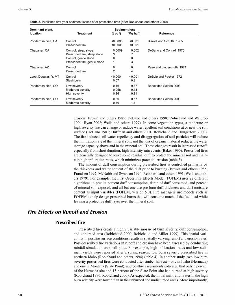
erosion (Brown and others 1985; DeBano and others 1998; Robichaud and Waldrop 1994; Ryan 2002; Wells and others 1979). In some vegetation types, a moderate or high severity fire can change or induce water repellent soil conditions at or near the soil surface (DeBano 1981; Huffman and others 2001; Robichaud and Hungerford 2000). The fire-induced soil water repellency and disaggregation of soil particles will reduce the infiltration rate of the mineral soil, and the loss of organic material reduces the water storage capacity above and in the mineral soil. These changes result in increased runoff, especially from short duration, high intensity rain events (Baker 1990). Prescribed fires are generally designed to leave some residual duff to protect the mineral soil and main-tain high infiltration rates, which minimizes potential erosion (table 3).
The amount of duff consumption during prescribed fires is controlled primarily by the thickness and water content of the duff prior to burning (Brown and others 1985; Frandsen 1997; McNabb and Swanson 1990; Reinhardt and others 1991; Wells and oth-ers 1979). For example, the First Order Fire Effects Model (FOFEM) uses 22 different algorithms to predict percent duff consumption, depth of duff consumed, and percent of mineral soil exposed, and all but one use pre-burn duff thickness and duff moisture content as input variables (FOFEM, version 5.0). Fire managers use models such as FOFEM to help design prescribed burns that will consume much of the fuel load while leaving a protective duff layer over the mineral soil.
Fire Effects on Runoff and Erosion
Prescribed firePrescribed fires create a highly variable mosaic of burn severity, duff consumption,
and unburned area (Robichaud 2000; Robichaud and Miller 1999). This spatial vari-ability in postfire surface conditions results in spatially varying runoff and erosion rates. Post-prescribed fire variations in runoff and erosion have been assessed by conducting rainfall simulation on small plots. For example, high infiltrations rates and low sedi-ment yields were reported after a spring season, low burn severity prescribed fire in northern Idaho (Robichaud and others 1994) (table 4). In another study, two low burn severity prescribed fires were conducted after timber harvest—one in Idaho (Hermada) and one in Montana (Slate Point), and postfire assessments indicated that only 5 percent of the Hermada site and 15 percent of the Slate Point site had burned at high severity (Robichaud 1996; Robichaud 2000). As expected, the initial infiltration rates in the high burn severity were lower than in the unburned and undisturbed areas. More importantly,
Table 3. Published first-year sediment losses after prescribed fires (after Robichaud and others 2000).
Dominantplant, Sedimentlosslocation Treatment (t ac-1) (Mg ha-1) Reference
Ponderosa pine, CA Control <0.0005 <0.001 Biswell and Schultz 1965 Prescribed fire <0.0005 <0.001
Chaparral, CA Control, steep slope 0.0009 0.002 DeBano and Conrad 1976 Prescribed fire, steep slope 3 7 Control, gentle slope 0 0 Prescribed fire, gentle slope 1 3
Chaparral, AZ Control 0 0 Pase and Lindenmuth 1971 Prescribed fire 2 4
Larch/Douglas-fir, MT Control <0.0004 <0.001 DeByle and Packer 1972 Slash burn 0.07 0.2
Ponderosa pine, CO Low severity 0.16 0.37 Benavides-Solorio 2003 Moderate severity 0.058 0.13 High severity 0.36 0.81
Ponderosa pine, CO Low severity 0.30 0.67 Benavides-Solorio 2003 Moderate severity 0.49 1.1
ChaPTer 5. fuel managemenT and erosion

USDA Forest Service RMRS-GTR-231. 2010. 91
the initial infiltration rates in the areas burned at low severity (which comprised the larg-est proportion of the prescribed burn area) fell within the upper end of the range from the areas left unburned and undisturbed areas (Robichaud 2000). The total sediment yields from the three 30-minute rainfall simulations on the plots burned at low severity were an order of magnitude smaller than the values from the plots burned at high sever-ity (table 4) (Robichaud 1996). Similar differences in sediment yields were reported by Benavides-Solorio and MacDonald (2005).
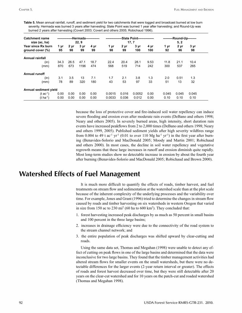
Runoff and sediment yields were also measured from natural rainfall events at the catchment-scale (17 to 22 ac, 7 to 9 ha) after the same prescribed burns at both Slate Point and Hermada. At both sites, the runoff and sediment yields were generally low from the catchments subjected to both timber harvest and prescribed burning (table 5) (Covert and others 2005). The low runoff and sediment yields were most likely due to the gener-ally low burn severity and the averaging of fire effects (Covert 2003; Robichaud 1996).
Earlier work also noted that erosion after prescribed fires occurred primarily in areas where the fires were locally severe or there was extensive disturbance due to forest harvesting (McNabb and Swanson 1990). A study of 200 permanent 11 ft2 (1-m2) plots in northern Idaho have a pre-harvest erosion of 0.04 t ac-1 (0.09 Mg ha-1). Prior to any activities, the litter coverage was 83 percent, and this decreased by just 8 percent 1 year after helicopter-logging and broadcast burning. One year after broadcast burning, the total erosion was 0.8 t ac-1 (1.9 Mg ha-1); 40 percent of this was attributed to the mechan-ical disturbance from logging and 32 percent to the broadcast burning (Clayton 1981).
Another study in northern Idaho measured erosion rates of 67.2 yd3 ac-1 yr-1 (127 m3
ha-1 yr-1) from a clearcut area that was then burned by a high severity wildfire (Megahan and Molitor 1975). No erosion was measured from an uncut watershed that burned in the same wildfire. Erosion pin data suggested a net soil loss of 0.43 in (11 mm) on the clearcut and burned watershed as compared to a net gain of 0.20 in (5 mm) on the uncut watershed. Rill erosion was observed within 30 days after the fire on the clearcut water-shed, while on the uncut watershed, there was some soil movement from rainsplash but there was no evidence of rilling (Megahan and Molitor 1975).
WildfireThe effects of high severity wildfires on runoff and erosion are generally much more
severe than the effects of prescribed fires. High severity fires are of particular concern
Table 4. Sediment yields from rainfall simulation studies on low severity burned plots (after Benavides-Solorio and MacDonald 2001; Johansen and others 2001; Robichaud 2000).
Rainfall intensity Slope [Rainfallduration] SedimentyieldDominantplant [Timesinceburn] (inh-1) (mm h-1)type, location (%) [(min)] [(min)] (t ac-1 in-1) (kg ha-1 mm-1) Reference
Sagebrush-juniper, CA — 2.6 65 0.034-0.083 3.0-7.3 Simanton and others 1986 [1 year] [30-60] [30-60]
Mixed conifer, ID 13-27 2.0 50 0.028-0.12 2.5-11.0 Robichaud and others 1994 [within days] [30] [30]
Pinon-juniper, NV 5-8 3.3 84 0.045-0.11 4.0-9.7 Roundy and others 1978 coppice [1-2 months] [60] [60] 0.035-0.15 3.1-12.8
Pinon-juniper, NV [1 year] 0.090-0.29 7.9-26.0 interspace 0.13-0.36 11.9-32.0
Ponderosa pine, CO 21-22 3.1 80 0.056-0.092 4.9-8.1 Benavides-Solorio [1-2 months] [60] [60] and MacDonald 2001
Douglas-fir, MT 30-70 3.7 94 0.094 8.3 Robichaud 1996 [within days] [90] [90]
Douglas-fir, ID 40-75 3.7 94 [within days] [90] [90] 0.41 35
P.r. roBiChaud, l.h. maCdonald, r.B. folTz CumulaTive WaTershed effeCTs of fuel managemenT in The WesTern uniTed sTaTes
92 USDA Forest Service RMRS-GTR-231. 2010.
Table 5. Mean annual rainfall, runoff, and sediment yield for two catchments that were logged and broadcast burned at low burn severity. Hermada was burned 3 years after harvesting; Slate Point was burned 1 year after harvesting; and Round-Up was burned 2 years after harvesting (Covert 2003; Covert and others 2005; Robichaud 1996).
Catchmentname --------------Hermada------------- ---------------SlatePoint--------------- ---------Round-Up-------- size (ac, ha) 22, 9 17, 7 5, 2Year since Rx burn 1 yr 2 yr 3 yr 4 yr 1 yr 2 yr 3 yr 4 yr 1 yr 2 yr 3 yr ground cover (%) 95 98 99 99 98 99 100 100 92 96 98
Annual rainfall (in) 34.3 26.5 47.1 18.7 22.4 20.4 28.1 9.53 11.8 21.1 10.4 (mm) 870 673 1196 474 568 519 714 242 300 537 265
Annual runoff (in) 3.1 3.5 13 7.1 1.7 2.1 3.8 1.3 2.0 0.51 1.3 (mm) 78 89 320 180 43 53 97 33 51 13 32
Annual sediment yield (t ac-1) 0.00 0.00 0.00 0.00 0.0015 0.016 0.0052 0.00 0.045 0.045 0.045 (t ha-1) 0.00 0.00 0.00 0.00 0.0033 0.036 0.012 0.00 0.10 0.10 0.10
because the loss of protective cover and fire-induced soil water repellency can induce severe flooding and erosion even after moderate rain events (DeBano and others 1998; Neary and others 2005). In severely burned areas, high intensity, short duration rain events have increased peakflows from 2 to 2,000 times (DeBano and others 1998; Neary and others 1999, 2005). Published sediment yields after high severity wildfires range from 0.004 to 49 t ac-1 yr-1 (0.01 to over 110 Mg ha-1 yr-1) in the first year after burn-ing (Benavides-Solorio and MacDonald 2005; Moody and Martin 2001; Robichaud and others 2000). In most cases, the decline in soil water repellency and vegetative regrowth means that these large increases in runoff and erosion diminish quite rapidly. Most long-term studies show no detectable increase in erosion by about the fourth year after burning (Benavides-Solorio and MacDonald 2005; Robichaud and Brown 2000).
Watershed Effects of Fuel ManagementIt is much more difficult to quantify the effects of roads, timber harvest, and fuel
treatments on stream flow and sedimentation at the watershed scale than at the plot scale because of the inherent complexity of the underlying processes and the variability over time. For example, Jones and Grant (1996) tried to determine the changes in stream flow caused by roads and timber harvesting on six watersheds in western Oregon that varied in size from 150 ac to 230 mi2 (60 ha to 600 km2). They concluded that:
1. forest harvesting increased peak discharges by as much as 50 percent in small basins and 100 percent in the three large basins;
2. increases in drainage efficiency were due to the connectivity of the road system to the stream channel network; and
3. the entire population of peak discharges was shifted upward by clear-cutting and roads.
Using the same data set, Thomas and Megahan (1998) were unable to detect any ef-fect of cutting on peak flows in one of the large basins and determined that the data were inconclusive for two large basins. They found that the timber management activities had altered stream flows for smaller events on the small watersheds, but there were no de-tectable differences for the larger events (2-year return interval or greater). The effects of roads and forest harvest decreased over time, but they were still detectable after 20 years on the clear-cut watershed and for 10 years on the patch-cut and roaded watershed (Thomas and Megahan 1998).
ChaPTer 5. fuel managemenT and erosion
USDA Forest Service RMRS-GTR-231. 2010. 93
Beschta and others (2000) also analyzed the same data set as Jones and Grant (1996) and they concluded that the increases in peakflows after harvest operations (includ-ing road building, clearcutting, cable logging, and site preparation) depended on the peakflow magnitude. Peakflow increases averaged approximately 13 to 16 percent after treatment for events with a recurrence interval of 1 year, and by 6 to 9 percent for storms with a recurrence interval of 5 years.
These different interpretations of the same data set reflect the challenges of assessing and understanding the effects of forest management activities at the watershed scale. The differences in site conditions, climatic regime, and treatment intensity mean that different studies have found very different results, and a study can be found to sup-port almost any point of view. For example, 11 watershed studies from sites in British Columbia to California can be cited to show that logging can increase, decrease, or have no effect on the size of peak flows (Harr 1979). Accurate predictions of the effects of fuel treatments are only possible if there is a simultaneous understanding of the underly-ing processes and how the different effects might be transmitted and aggregated at the watershed scale.
ConclusionsFuel management in forested areas can involve a number of activities, including the
construction, maintenance, and use of forest access roads; timber cutting and removal; non-commercial thinning or mastication; and prescribed fire. The following conclu-sions reflect our current understanding of the effects of fuel treatments at the plot and watershed scales:
1. Roads greatly increase runoff and erosion rates at the plot and road segment scale. The effect of these increases at the watershed scale depends on the connectivity of the road and stream networks, but several studies have indicated that roads have minimal effect on runoff at larger spatial scales. More studies have shown that unpaved forest roads are chronic sediment sources and that roads can significantly increase sediment yields on small to moderate-sized catchments. Road building, maintenance, and obliteration can generate significant short-term increases in runoff and sediment. The effects of forest roads on runoff and sediment yields can be greatly reduced by improved road placement, road designs that dissipate runoff and direct it away from streams, and the widespread use of erosion mitigation techniques.
2. Non-commercial thinning operations (without yarding) have small, short-lived impacts on runoff and sediment production, even when operations extend over large areas.
3. Commercial thinning and yarding has a greater potential to increase runoff, erosion, and sediment yields because of the more extensive removal of the forest canopy; greater ground disturbance due to skid trails, cable rows, and landings; greater ground disturbance due to more intensive harvest; need for extensive road access; and increase in heavy truck traffic. The potential increases in erosion and sediment yield can be minimized by reducing the area and amount of soil disturbance, establishing buffer strips along stream channels, and minimizing overland flow by restoring severely disturbed areas.
4. High severity wildfires increase runoff and erosion rates by two or more orders of magnitude, while low and moderate severity burns have much smaller effects on runoff and sediment yields. If areas are burned at low severity, the potential for increasing peak flows and erosion rates is relatively small. However, if prescribed fires are conducted under dry duff moisture conditions and larger areas are burned at high severity, there is a much greater risk for significantly increasing runoff and erosion rates. The natural regrowth on severely burned areas means that overland flow rates and sediment yields generally return to pre-burn levels in approximately 4 years. Water yields may remain elevated for a longer period due to the time required for interception and transpiration rates to return to pre-burn levels.
P.r. roBiChaud, l.h. maCdonald, r.B. folTz CumulaTive WaTershed effeCTs of fuel managemenT in The WesTern uniTed sTaTes

94 USDA Forest Service RMRS-GTR-231. 2010.
5. Vegetative recovery after fuel treatments is generally very rapid, with erosion rates typically dropping to pre-fire levels within 1 to 2 years. Hydrologic recovery after fuel treatments also tends to be more rapid than after clearcutting or high burn severity fires because a smaller proportion of the forest canopy is being removed.
6. Fuel management treatments generally are needed every 10 to 20 years and the associated cumulative effects occur during each access and treatment cycle. Although hillslope erosion rates recover quickly, the road system, which is typically used and maintained between treatment activities, is a chronic source of sediment. Sediment yields from high severity wildfires are much greater than the increase in sediment yields due to fuel management activities, but the recurrence interval of such wildfires can be hundreds of years. Over longer time scales, the cumulative impacts of fuel treatments, repeated at 10 to 20 year intervals, when combined with the impacts of continuous road maintenance and use, may be similar to the pulse impact from wildfires.
The cumulative effect of fuel management activities is related to their location and concentration within a given watershed as well as the degree and frequency of distur-bance for each activity. The watershed-scale impacts of any fuel management activity must consider the associated activities of road use, road maintenance, increased traffic, and multiple entries with various types of equipment as well as the combined effects of all the fuel treatments being applied. However, these effects are complex and inter-related. Few studies have examined the role of different controlling factors, much less the effects and interactions of the different activities on runoff and erosion at the water-shed scale. Identifying the cumulative effects of timber harvest activities is a continuing challenge, as it is almost impossible to quantify the relative contribution of each activity at each location. It follows that determining the cumulative effects of fuel treatments, which generally cause less disturbance than timber harvesting, will be even more of a challenge.
Knowledge GapsAdditional research is needed to understand the cumulative effects of fuel treatments
at the watershed scale. Research to date has identified and quantified some of the key factors relevant to fuel treatment operations, but the combined effects of these variables are not well understood. In particular, studies are needed in the following areas to de-termine the
1. change in peak flows, soil moisture, and sediment yields from repeated entries into the forest for fuel management operations on various soil types, precipitation regimes, and scales—both time and area;
2. extent to which roads, burned areas, and timber harvest units are connected to stream networks and how this connectivity changes over time as a function of the precipitation regime and site conditions; and
3. changes in runoff and sediment yields due to reopening brushed-in, low-use forest roads for fuel management activities.
ReferencesAgee, J.K. 1993. Fire ecology of Pacific Northwest forests. Island Press. Washington, DC. 493 p.Arno, S.F.; Gruell, G.E. 1986. Douglas-fir encroachment into mountain grasslands in southwestern
Montana. Journal of Range Management. 39(3): 272-276.Austin, S.A. 1999. Streamflow response to forest management: A meta-analysis using published
data and flow duration curves. Fort Collins, CO. Colorado State University. 121 p. Thesis.
ChaPTer 5. fuel managemenT and erosion
USDA Forest Service RMRS-GTR-231. 2010. 95
Baker, M.B., Jr. 1990. Hydrologic and water quality effects of fire. In: Proceedings of effects of fire management of Southwestern natural resources. GTR-RM-191. Ft. Collins, CO. USDA Forest Service. Rocky Mountain Research Station: 31-42.
Baker, W.L. 1993. Spatially heterogeneous multi-scale response of landscapes to fire suppression. Oikos. 66(1): 66-71.
Bates, C.G.; Henry, A.J. 1928. Forest and streamflow experiment at Wagon Wheel Gap, Colorado. Monthly Weather Review Supplement No. 3. USDA Weather Bureau. Washington, DC. 79 p.
Benavides-Solorio, J.D. 2003. Post-fire runoff and erosion at the plot and hillslope scale, Colorado Front Range. PhD dissertation. Dept. of Earth Resources. Colorado State University. Fort Collins. 218 p.
Benavides-Solorio, J.D.; MacDonald, L.H. 2001. Post-fire runoff and erosion from simulated rainfall on small plots, Colorado Front Range. Hydrological Processes. 15: 2931-2952.
Benavides-Solorio, J.D.; MacDonald, L.H. 2005. Measurement and prediction of post-fire erosion at the hillslope scale, Colorado Front Range. International Journal of Wildland Fire. 14: 1-18.
Beschta, R.L.; Pyles, M.R.; Skaugset, A.E.; Surfleet, C.G. 2000. Peakflow responses to forest practices in the western Cascades of Oregon, USA. Journal of Hydrology. 233: 102-120.
Bethlahmy, N.; Kidd, W.J. 1966. Controlling soil movement from steep road fills. USDA Forest Service. Res. Note INT-45. Intermountain Forest and Range Experiment Station Ogden, UT. 4 p.
Biswell, H.H.; Schultz, A.M. 1965. Surface erosion as related to prescribed burning. Journal of Forestry. 55: 372-374.
Bilby, R.E. 1985. Contributions of road surface sediment to a western Washington stream. Forest Science. 31(4): 827-838.
Bilby, R.E.; Sullivan, K.; Duncan, S.H. 1989. The generation and fate of road-surface sediment in forested watersheds in southwestern Washington. USDA Forest Science. 35(2): 453-468.
Binkley, D.; Brown, T.C. 1993. Forest practices as nonpoint sources of pollution in North America. Water Resources Bulletin. 29(5): 729-740.
Bisson, P.A.; Cleaves, D.A.; Everest, F.H.; Furnish, J.R.; Furniss, M.J.; Holthausen, R.S.; Manning, C.; Peterson, G.L.; Pettigrew, T.; Philips, R.; Prausa, R.; Raphael, M.G.; Timko, B.; Ziemer, R.R. 1999. Roads analysis: Informing decisions about managing the National Forest Transportation System. Misc. Rep. FS-643. USDA Forest Service. Rocky Mountain Research Station. 35 p.
Bosch, J.M.; Hewlett, J.D. 1982. A review of catchment experiments to determine the effect of vegetation changes on water yield and evapotranspiration. Journal of Hydrology. 55: 3-23.
Brown, H.E.; Baker Jr., M.B.; Rogers, J.J.; Cleary,W.P.; Kovner, J.L.; Larson, F.R.; Avery, C.C.; Campbell, R.E. 1974. Opportunities for increasing water yields and other multiple use values on ponderosa pine forest lands. Res. Pap. RM-RP-129. Fort Collins, CO. USDA Forest Service. 36 p.
Brown, E.; MacDonald, L.H. 2005. Upper South Platte Watershed Protection and Restoration Project: Progress report for 1 January-31 December 2004. Submitted to Pike-San Isabel National Forest. Colorado Springs, CO. 27 p.
Brown, E.; MacDonald, L.H.; Libohova, Z. 2005. Effects of forest thinning in the Upper South Platte Watershed, Colorado: AGU Hydrology Days. Fort Collins, CO. [Place of publication unknown]. American Geophysical Union. Abstract.
Brown, J.K.; Marsden, M.A.; Ryan, K.C.; Reinhardt, E.D. 1985. Predicting duff and woody fuel consumed by prescribed fire in the northern Rocky Mountains. Res. Pap. INT-RP-337. Ogden, UT. USDA Forest Service. Intermountain Research Station. 23 p.
Brown, T.M. 2002. Short-term total suspended-solid concentrations resulting from stream crossing obliteration in the Clearwater National Forest. M.S. Thesis. University of Washington. Seattle, WA. 107 p.
Brown, H.E.; Baker Jr., M.B.; Rogers, J.J.; Cleary,W.P.; Kovner, J.L.; Larson, F.R.; Avery, C.C.; Campbell, R.E. 1974. Opportunities for increasing water yields and other multiple use values on ponderosa pine forest lands. Res. Pap. RM-RP-129. Fort Collins, CO. USDA Forest Service. 36 p.
Buckhouse, J.C.; Gaither, R.E. 1982. Potential sediment production within vegetative communities in Oregon’s Blue Mountains. J. Soil and Water Conservation. 37(2): 120-122.
Bunte, K.; MacDonald, L.H. 1999. Scale considerations and the detectability of sedimentary cumulative watershed effects. Technical Bulletin No. 776, National Council for Air and Stream Improvement Research. Triangle Park, NC. 327 p.
P.r. roBiChaud, l.h. maCdonald, r.B. folTz CumulaTive WaTershed effeCTs of fuel managemenT in The WesTern uniTed sTaTes

96 USDA Forest Service RMRS-GTR-231. 2010.
Burroughs, E.R., Jr.; King, J.G. 1989. Reduction of Soil Erosion on Forest Roads. Res. Pap. INT-GTR-264. USDA Forest Service. Intermountain Research Station. 21 p.
Clayton, J.L. 1981. Soil disturbance caused by clearcutting and helicopter yarding in the Idaho batholith. Res. Note INT-305. Odgen, UT. USDA Forest Service. Intermountain Research Station. 7 p.
Covert, A.S. 2003. Accuracy assessment of WEPP-based erosion models on three small, harvested and burned forest watersheds. Moscow, ID. University of Idaho. 49 p. Thesis.
Covert, S.A.; Robichaud, P.R.; Elliot, W.J.; Link, T.E. 2005. Evaluation of runoff prediction from WEPP-based erosion models for harvested and burned forest watersheds. Transactions of the American Society of Agricultural Engineering. 48(3): 1091-1100.
Croke, J.C.; Mockler, S.P. 2001. Gully initiation and road to stream linkage in a forested catchment in southeast Australia. Earth Surface Processes and Landforms. 26: 1-13.
DeBano, L.F. 1981. Water repellant soils: A state-of-the-art. PSW-GTR-46. USDA Forest Service. Pacific Southwest Forest and Range Experiment Station. Berkeley, CA. 21 p.
Debano, L.F.; Conrad, C.E. 1976. Nutrients lost in debris and runoff water from a burnt chaparral watershed. Proc. of 3rd Inter-Agency Sedimentation Conference. Denver, CO. 3: 13-27.
DeBano, L.F.; Neary, D.G.; Ffolliott, P.F. 1998. Fire’s effects on ecosystems. New York. John Wiley & Sons. 333 p.
Debyle, N.V.; Packer, P.E. 1972. Plant nutrient and soil losses in overland flow from burned forest clearcuts in: Water in transition. Proceedings of symposium held at Fort Collins, CO. June 19-22, 1972. Urbana, IL. American Water Resources Assoc. Proceedings series. 14: 296-307.
Dyrness, C.T. 1970. Stabilization of newly constructed road backslopes by mulch and grass-legume treatments. Research Note PNW-123. USDA Forest Service. Pacific Northwest Forest and Range Experimental Station. 5 p.
Dyrness, C.T. 1975. Grass-legume mixtures for erosion control along forest roads in western Oregon. Journal Soil Water Conserv. 30: 169-173.
FOFEM—a First Order Fire Effects Model (Version 5) [Online]. http://fire.org. [July 2009] Produced by: Keane, B.; Reinhardt, E.; Brown, J.; Gangi, L. USDA Forest Service. Intermountain Fire Sciences Laboratory. Rocky Mountain Research Station. Missoula, MT.
Foltz, R.B. 1996. Traffic and no-traffic on an aggregate surfaced road: Sediment production differences. In: Proceedings of the seminar on environmentally sound forest roads and wood transport. June 17-22, Sinaia, Romania. Food and Agriculture Organization of the UN. Rome, Italy: 195-204.
Foltz, R.B. 2003. Environmental impacts of forest roads: An overview of the state of the knowledge. In: Wide, M.I.; Baryd, B [Eds.]. Proceedings of the Second Forest Engineering Conference. May 12-15. Vaxjo, Sweden. Skogforsk Uppsala, Sweden. 121-128.
Foltz, R.B.; Elliot, W.J. 1996. Measuring and modeling impacts of tire pressure on road erosion. In: Proceedings of the seminar on environmentally sound forest roads and wood transport. July 17-22. Sinaiah, Romania. Food and Agriculture Organization of the UN. Rome, Italy: 205-214.
Foltz, R.B.; Trube, M.A. 1995. Effect of aggregate quality on sediment production from a forest road. In: Proceedings of the Sixth International Conference on low-volume roads. Transportation Research Board. National Research Council. Washington, DC. 1: 49-57.
Foltz, R.B.; Truebe, M. 2003. Locally available aggregate and sediment production. Transportation Research Record. Transportation Research Board. National Academies of Science. Washington, DC. Paper No. LVR8-1050. Presented at the 8th International Conference on low-volume roads. June 22-25, 2003. Silver Legacy Hotel & Conference Center. Reno, NV. 1819(2): 185-193.
Frandsen, W.H. 1997. Ignition probability of organic soils. Canadian Journal of Forest Resources. 21: 1471-1477.
Gary, H.L. 1975. Watershed management problems and opportunities for the Colorado Front Range ponderosa pine zone: The status of our knowledge. Res. Pap. RM-RP-139. Fort Collins, CO. USDA Forest Service. 32 p.
Gucinski, H.; Furniss, M.J.; Ziemer, R.R.; Brookes, M.H. 2001. Forest roads: A synthesis of scientific information. PNW-GTR-509. Portland, OR. USDA Forest Service. Pacific Northwest Research Station. 103 p.
Harr, R.D. 1979. Effects of timber harvest on streamflow in the rain dominated portion of the Pacific Northwest. Presented at workshop on scheduling timber harvest for hydrologic concerns. Portland OR. USDA Forest Service. 45 p.
ChaPTer 5. fuel managemenT and erosion
USDA Forest Service RMRS-GTR-231. 2010. 97
Haupt, H.F.; Kidd, W.J., Jr. 1965. Good logging practices reduce sedimentation in Central Idaho. Journal of Forestry. 63(9): 664-670.
Heede, B.H. 1987. Overland flow and sediment delivery five years after timber harvest in mixed conifer forest, Arizona, USA. Journal of Hydrology 91:205-216.
Huffman, E.L.; MacDonald, L.H.; Stednick, J.D. 2001. Strength and persistence of fire-induced soil hydrophobicity under ponderosa and lodgepole pine, Colorado Front Range. Hydrological Processes. 15: 2877-2892.
IDEQ (Idaho Department of Environmental Quality). 1994. IDAPA 58.0102. Water quality standards and wastewater treatment requirements: 250. Surface water quality criteria for aquatic life use designations, section e. [Online]. http://adm.idaho.gov/adminrules/rules/idapa58/0102.pdf. [July 2009].
Iverson, R.M. 1980. Processes of accelerated pluvial erosion on desert hillslopes modified by vehicular traffic. Earth Surface Processes. 5: 369-388.
Johansen, M.P.; Hakonson, T.E.; Breshears, D.D. 2001. Post-fire runoff and erosion from rainfall simulation: Contrasting forests with shrublands and grasslands. Hydrol. Processes. 15: 2953-2965.
Jones, J.A.; Grant, G.E. 1996. Peak flow responses to clear-cutting and roads in small and large basins, western Cascades, Oregon. Water Resources Research. 32(4): 959-974.
Keane, R.E.; Ryan, K.C.; Veblen, T.T.; Allen, C.D.; Logan, J.; Hawkes, B. 2002. Cascading effects of fire exclusion in Rocky Mountain ecosystems. RMRS-GTR-91. Fort Collins, CO. USDA Forest Service. Rocky Mountain Research Station. 31 p.
King, J.G. 1994. Streamflow and sediment yield responses to forest practices in Northern Idaho. In: Baumgartner, D.M.; Lotan, J.E.; Tonn, J.R. [Eds.]. Proceedings of Interior cedar-hemlock-white pine forests: Ecology and management. March 2-4, 1993. Spokane, WA. Department of Natural Resources Sciences. Washington State University. Pullman, WA: 213-220.
Lewis, J. 1998. Evaluating the impact of logging activities on erosion and suspended sediment transport in Caspar Creek Watersheds. In: Conference on coastal watersheds: The Casper Creek story; 6 May 1998. PSW-GTR-168. USDA Forest Service: 55-71.
Lindeburgh, S.B. 1990. Effects of prescribed fire on site productivity: A literature review. Land Management Report Number 66. BC Ministry of Forests. Research Branch. Victoria, BC. 15 p.
Loftis, J.C.; MacDonald, L.H.; Streett, S.; Iyer, H.K.; Bunte, K. 2001. Detecting cumulative watershed effects: The power of paring. Journal of Hydrology. 251: 49-64.
Lopes, V.L.; Ffolliott, P.F.; Baker, M.B., Jr. 2001. Impacts of vegetative practices on suspended sediment from watersheds in Arizona. J. Water Resour. Plan. Manage. 127: 41-47.
Lousier, J.D. 1990. Impacts of forest harvesting and regeneration on forest sites. Land Management Report Number 67. BC Ministry of Forests. Research Branch. Victoria, BC. 105 p.
Luce, C.H.; Black, T.A. 1999. Sediment production from forest roads in western Oregon. Water Resources Research. 35(8): 2561-2570.
Luce, C.H.; Black, T.A. 2001. Effects of traffic and ditch maintenance on forest road sediment production. Seventh Federal Interagency Sedimentation Conference. Reno, NV. 8 p.
Luce, C.H.; Cundy, T.W. 1992. Modification of the kinematic wave-Philip infiltration overland flow model. Water Resources Research. 28(4): 1179-1186.
MacDonald, L.H. 2000. Evaluating and managing cumulative effects: Process and constraints. Environmental Management. 26(3): 299-315.
MacDonald, L.H.; Coe D.B.; Litschert, S.E. 2004. Assessing cumulative watershed effects in the central Sierra Nevada: Hillslope measurements and catchment-scale modeling. In: Murphy, D.D.; Stine, P.A. [Eds.]. Proceedings of the Sierra Nevada science symposium. October 7-10, 2002. Kings Beach, CA. PSW-GTR-193. Albany, CA. Pacific Southwest Research Station. USDA Forest Service: 149-157.
MacDonald, L.H.; Stednick, J.D. 2003. Forests and water: A state-of-the-art review for Colorado. Colorado Water Resources Research Institute Rep. No. 196. Fort Collins, CO. Colorado State University. 65 p.
Madrid, A. 2005. Evaluation of forest thinning effects on runoff, infiltration, sediment yield, and vegetative cover in a northern New Mexico forest. Unpublished progress report. Las Cruces, NM. New Mexico State University. 24 p.
Madrid, A.; Fernald, A.G.; Baker, T.T.; Vanleeuwen, D.M. 2006. Evaluation of silvicultural treatment effects on infiltration, runoff, sediment yield, and soil moisture in a mixed conifer New Mexico forest. Journal of Soil Water Conservation. 61(3): 159-168.
P.r. roBiChaud, l.h. maCdonald, r.B. folTz CumulaTive WaTershed effeCTs of fuel managemenT in The WesTern uniTed sTaTes

98 USDA Forest Service RMRS-GTR-231. 2010.
McClurkin, D.C.; Duffy, P.D.; Nelson, N.S. 1987. Changes in forest floor and water quality following thinning and clearcutting of 20-year-old pine. Journal of Environmental Quality. 16(3): 237-291.
McNabb, D.H.; Swanson, F.J. 1990. Effects of fire on soil erosion. In: Walstad, J.D.; Radosevich, S.R.; Sandberg, D.V. [Eds.]. Natural and prescribed fire in Pacific Northwest forest. Corvallis, OR. Oregon State University Press: 159-176.
Megahan, W.F. 1974. Erosion over time on severely disturbed granitic soils: A model. Res. Pap. INT-RP-156. USDA Forest Service. Intermountain Research Station. 21 p.
Megahan, W.F. 1975. Sedimentation in relation to logging activities in the mountains of central Idaho. In: Present and prospective technology for predicting sediment yields and sources. Sediment-Yield Workshop. USDA Forest Service. Sedimentation Laboratory: 74-82.
Megahan, W.F. 1978. Erosion processes on steep granitic road fills in central Idaho. Proceedings of the Soil Science Society of America Journal. 42(2): 350-357.
Megahan, W.F. 1980. Erosion from roadcuts in granitic slopes of the Idaho batholith. Proceedings Cordilleran section of the Geological Society of America. 76th Annual Meeting. Oregon State Univ. Corvallis, OR. 120 p.
Megahan, W.F.; Ketcheson, G.L. 1996. Predicting downslope travel of granitic sediments from forest roads in Idaho. Water Resources Bulletin. 32(2): 371-382.
Megahan, W.F.; Kidd, W.J. 1972. Effects of logging and logging roads on erosion and sediment deposition from steep terrain. J. Forestry. 70(3):136-141.
Megahan, W.F.; King, J. G. 2004. Erosion, sedimentation, and cumulative effects in the Northern Rocky Mountains. In: Ice, G.G; Stednick, J.D. [Eds.]. A Century of Forest and Wildland Watershed Lessons. Bethesda, MD. Society of American Foresters. 9:201-222.
Megahan, W.F.; Molitor, D.C. 1975. Erosion effects of wildfire and logging in Idaho. In: Watershed management symposium. 1975 August. Logan, UT. New York. American Society of Civil Engineers Irrigation and Drainage Division: 423-444.
Megahan, W.F.; Potyondy, J.P.; Seyedbagheri, K.A. 1992. Best management practices and cumulative effects from sedimentation in the South Fork Salmon River: An Idaho case study. In: Naiman, R.J. [Ed.]. Watershed management. Balancing sustainability with environmental change. New York: Springer-Verlag. Chapter 15. 401-414.
Megahan, W.F.; Seyedbagheri, K.A.; Dodson, P.C. 1983. Long term erosion on granitic roadcuts based on exposed tree roots. Earth Surface Processes and Landforms. 8: 19-28.
Megahan, W.F.; Wilson, M.; Monsen, S.B. 2001. Sediment production from granitic cutslopes on forest roads in Idaho, USA. Earth Surf Process Landforms. 26: 153-163.
Montgomery, D.M. 1994. Road surface drainage, channel initiation, and slope stability. Water Resources Research. 30: 1925-1932.
Moody, J.A.; Martin, D.A. 2001. Initial hydrologic and geomorphic response following a wildfire in the Colorado Front Range. Earth Surface Processes and Landforms. 26: 1049-1070.
Neary, D.G.; Klopatek, C.C.; DeBano, L.F.; Ffolliott, P.F. 1999. Fire effects on belowground sustainability: A review and synthesis. Forest Ecology and Management. 122: 51-71.
Neary, D.G.; Ryan, K.C.; DeBano, L.F.; Landsberg, J.D.; Brown, J.K. [Eds.]. 2005. Wildland fire in ecosystems: Effects of fire on soil and water. RMRS-GTR-42-vol 4. Ogden, UT. USDA Forest Service. Rocky Mountain Research Station. 250 p.
Norris, L.A. 1990. An overview of and synthesis of knowledge concerning natural and prescribed fire in Pacific Northwest forest. In: Walstad, J.D.; Radosevich, S.R.; Sandberg, D.V. [Eds.]. Natural and Prescribed Fire in Pacific Northwest Forests. Oregon State University Press. Corvallis, OR: 7-22.
Pase, C.P.; Lindenmuth, A.W. 1971. Effects of prescribed fire on vegetation and sediment in oak-mountain mahogany chaparral. Journal of Forestry. 69(11): 800-805.
Reid, L.M.; Dunne, T. 1984. Sediment production from forest road surfaces. Water Resources Research. 20(11): 1753-1761.
Reinhardt, E.G.; Brown, J.K.; Filcher, W.C.; Graham, R.T. 1991. Woody fuel and duff consumption by prescribed fire in the northern Idaho mixed conifer logging slash. Res. Pap. INT-RP-443. Ogden, UT. USDA Forest Service. Intermountain Research Station. 23 p.
Rice, R.M.; Datzman, P.A.1981. Erosion associated with cable and tractor logging in northwestern California. In: Erosion and sediment transport in Pacific Rim Steeplands. I.A.H.S. Publ. No. 132. Christchurch, New Zealand: 362-374.
Rice, R.M.; Furbish, D.J. 1981. Erosion and soil displacement related to timber harvesting in northwestern California. Paper for 17th IUFRO World Congress. Kyoto, Japan.
ChaPTer 5. fuel managemenT and erosion

USDA Forest Service RMRS-GTR-231. 2010. 99
Rice, R.M.; Rothacher, J.S.; Megahan, W.F. 1972. Erosional consequences of timber harvesting: An appraisal. In: Watersheds in transition. Amer. Water Res. Assoc. Urbana, IL. 321-329.
Robichaud, P.R. 1996. Spatially-varied erosion potential from harvested hillslopes after prescribed fire in the interior Northwest. Dissertation. University of Idaho. Moscow, ID. 219 p.
Robichaud, P.R. 2000. Fire effects on infiltration rates after prescribed fire in northern Rocky Mountain forests, USA. Journal of Hydrology. 231-232(1-4): 220-229.
Robichaud, P.R.; Beyers, J.L.; Neary, D.G. 2000. Evaluating the effectiveness of postfire rehabilitation treatments. RMRS-GTR-63. Fort Collins, CO. USDA Forest Service. Rocky Mountain Research Station. 85 p.
Robichaud, P.R.; Brown, R.E. 1999, revised 2000. What happened after the smoke cleared: Onsite erosion rates after a wildfire in eastern Oregon. In: Olsen, D.S.; Potyondy, J.P. [Eds.]. Proceedings of the wildland hydrology conference. American Water Resource Association. Hernon, VA: 419-426.
Robichaud, P.R.; Graham, R.T.; Hungerford, R.D. 1994. Onsite sediment production and nutrient losses from a low-severity burn in the interior northwest. In: Baumgartner, D.M.; Lotan, J.E.; Tonn, J.R. [Eds.]. Proceedings of Interior Cedar-Hemlock-White Pine Forests: Ecology and Management. March 2-4, 1993. Spokane, WA. Department of Natural Resources Sciences. Washington State University. Pullman, WA: 227-232.
Robichaud, P.R.; Hungerford, R.D. 2000. Water repellency by laboratory burning of four northern Rocky Mountain forest soils. Journal of Hydrology: 231-232(1-4): 207-219.
Robichaud, P.R.; Miller, S.M. 1999. Spatial interpolation and simulation of post-burn duff thickness after prescribed fire. International Journal of Wildland Fire. 9(2): 137-143.
Robichaud, P.R.; Waldrop, T.A. 1994. A comparison of surface runoff and sediment yields from a low- and high-severity site preparation burns. Water Resources Bulletin. 30(1): 27-34.
Roundy, B.A.; Blackburn, W.H.; Eckert, R. E., Jr. 1978. Influence of prescribed burning on infiltration and sediment production in the pinyon-juniper woodland, Nevada. Journal of Range Management. 31(4): 250-253
Ryan, K.C. 2002. Dynamic interactions between forest structure and fire behavior in boreal ecosystems. Silva Fennica. 36(1): 13-39.
Skaugset, A.; Allen, M.M. 1998. Forest road sediment and drainage monitoring project report for private and state lands in western Oregon. Prepared for the Oregon Department of Forestry. Forest Engineering Department. Oregon State University. Corvallis, OR. 21 p.
Schumm, S.A. 1971. Fluvial geomorphology: Channel adjustment and river metamorphosis. In: Shen, H.W. [Ed.]. Fort Collins, Colorado. River Mechanics.Vol. 1: 1-22.
Simanton, J.R.; Johnson, C.W.; Nyhan, J.W.; Romney, E.M. 1986. Rainfall simulation on rangeland erosion plots. In: Lane, L.J. [Ed.]. Proceedings of the Rainfall Simulator Workshop. Tucson, AZ. January, 14-15. Society for Range Management: Denver, CO. 68 p.
Small Woodlands Program of BC. 2002. Managing your woodland: A non-foresters guide to small-scale forestry in British Columbia. 2002. Small Woodlands Program of BC and Canadian Forest Service. Victoria, BC. 303 p.
Soto, B.; Basanta, R.; Benito, E.; Perez, R.; Diaz-Fierros, F. 1994. Runoff and erosion from burnt soils in northwest Spain. In: Sala , M.; Rubio, J.L. [Eds.]. Proceedings: Soil erosion and degradation as a consequence of forest fires. 1991. Barcelona, Spain: 91-98.
Stednick, J.D. 1987. Potential for sub-alpine forest management practices on sediment production. In: Management of sub-alpine forests: Building on 50 years of research. GTR-RM-149. Fort Collins, CO. USDA Forest Service: 95-100.
Stednick, J.D. 2000. Timber management. In: Drinking water from forest and grasslands: A synthesis of the scientific literature. SRS-GTR-39. USDA Forest Service. Southern Research Station: 103-119.
Swank, W.T.; DeBano, L.F.; Nelson, D. 1989. Effects of timber management practices on soil and water. In: Burns, Russell [Tech. comp.]. The scientific basis for silvicultural and management decisions in the National Forest System. GTR-WO-55. Washington, DC. USDA Forest Service: 79-106.
Thomas, R.B.; Megahan, W.F. 1998. Peak flow responses to clear-cutting and roads in small and large basins, western Cascades, Oregon: A second opinion. Water Resources Research. 34(12): 3393-3403.
Tiedemann, A.R.; Conrad, C.E.; Dieterich, J.H.; Hornbeck, J.W.; Megahan, W.F.; Viereck, L.A.; Wade, D.D. 1979. Effects of fire on water, a state-of-knowledge review. GTR-WO-10. Washington, DC. USDA Forest Service. 28 p.
P.r. roBiChaud, l.h. maCdonald, r.B. folTz CumulaTive WaTershed effeCTs of fuel managemenT in The WesTern uniTed sTaTes
100 USDA Forest Service RMRS-GTR-231. 2010.
Troendle, C.A.; King, R.M. 1985. The effect of timber harvest on the Fool Creek Watershed, 30 years later. Water Resources Research. 21(12): 1915-1922.
Troendle, C.A.; Olsen, W.K. 1993. Potential effects of timber harvest and water management on streamflow dynamics and sediment transport. In: Sustainable ecological systems: Implementing an ecological approach to land management. RM-GTR-247. USDA Forest Service: 34-41.
Troendle, C.A.; Wilcox, M.S.; Bevenger, G.S.; Porth, L.S. 2001. The Coon Creek water yield augmentation project: Implementation of timber harvesting technology to increase streamflow. Forest Ecology and Management. 143:179-187.
Truebe, M.; Evans, G. 1994. Lowell surfacing thickness design test road: Final report. Federal Highway Administration Report FHWA-FLP-94-008. USDA Forest Service. SanDimas Technology and Development Center. San Dimas, CA. 108 p.
USDA Forest Service. 2000. Clearwater National Forest road decommissioning handbook [Draft]. USDA Forest Service. Powell Ranger District. 67 p.
Vincent, K.R. 1979. Runoff and erosion from a logging road in response to snowmelt and rainfall. University of California at Berkeley. Berkeley, CA. M.S. Thesis. 60 p.
Wald, A.R. 1975. The impact of truck traffic and road maintenance on suspended sediment yield from a 14’ standard forest road. MS Thesis. University of Washington. Seattle, WA. 38 p.
Waldstad, J.D.; Seidel, K.W. 1990. Use and benefits of prescribed fire in reforestation. In: Waldstad, J.D.; Radosevich, S.R.; Sandberg, D.V. [Eds.]. Natural and Prescribed Fire in Pacific Northwest Forests. Corvallis, OR. Oregon State University Press. 67-79.
Waldstad, J.D.; Radosevich, S.R.; Sandberg, D.V. 1990. Introduction to natural and prescribed fire in Pacific Northwest forests. In: Waldstad, J.D.; Radosevich, S.R.; Sandberg, D.V. [Eds.]. Natural and prescribed fire in Pacific Northwest forests. Corvallis, OR. Oregon State University Press. 3-5.
Washington Forest Practices Board. 1995. Standard methodology for conducting watershed analysis. Version 3.0. November 1995. Washington State Department of Natural Resources. Olympia, WA: B1-B52.
Wells, C.G.; Campbell, R.E.; DeBano, L.F.; Lewis, C.E.; Fredriksen, R.L.; Franklin, E.D.; Froelich, R.C.; Dunn, P.H. 1979. Effects of fire on soil: A state-of-knowledge review. WO-GTR-7. Washington, DC. USDA Forest Service. 34 p.
Wemple, B.C. 1994. Hydrologic integration of forest roads with stream networks in two basins, western Cascades, Oregon. Corvallis, OR. Oregon State University. Thesis.
Wemple, B.C.; Jones, J.A.; Grant, G.E. 1996. Hydrologic integration of forest roads with stream networks in two forested basins in the western Cascades of Oregon. Water Resources Bulletin. 32: 1195-1207.
Williams, J.D.; Buckhouse, J.C. 1993. Winter logging and erosion in a ponderosa pine forest in northeastern Oregon. Western Journal of Applied Forestry. 8: 19–23.
Wilson, R.L. 1963. Source of erosion on newly constructed logging roads in the H.J. Andrews experimental forest. Unpublished report. Bureau of Land Management. University of Washington. Seattle, WA. 21 p.
ChaPTer 5. fuel managemenT and erosion


![Bureau of Watershed Management Regulatory Proposal Chapter 102 [Erosion and Sediment Control] Erosion, Sediment and Stormwater Management February 21,](https://static.fdocuments.us/doc/165x107/5697bfd61a28abf838cae07f/bureau-of-watershed-management-regulatory-proposal-chapter-102-erosion-and.jpg)


