From Track to Tarmac - North Sydney Council · From Track to Tarmac A walking tour of Blues Point...
14
From Track to Tarmac A walking tour of Blues Point Road, McMahons Point Distance: 2 Km Approximate time: 3 hours Grading: low to medium Introduction Blues Point Road began life as a dirt track from Billy Blue‘s ‗Northampton Farm‘ to the Township of St. Leonards. In the first half of the 19 th century, the north shore was a remote and largely unpopulated district, and the only means of communication with the main colony on the south shore was to hire the services of a waterman for the trip across the water. In 1817 William Blue received 80 acres ‗free from all taxes, quit rents and other acknowledgements for the space of five years from the date thereof‘ on the North Shore. He named his property ‗Northampton Farm‘ and moved here with his wife and six children. At the same time he was appointed official ferryman to the north side and commenced a regular rowing service between his farm and Dawes Point. Following ‗the Old Commodore‘s‘ death in 1834, Billy‘s eldest son William continued to ply a ferry between Blues Point and Sydney, thus confirming Blues Point Road‘s status as the most important commuting route on the North Shore. Soon after Blues Point Road was officially gazetted in 1839, William junior died, bringing about the first subdivision of the Estate and the beginnings of the present suburb of McMahons Point. Various shops and businesses, several hotels, a school and church were established along this thoroughfare to service the needs of the commuting public. By the 1870s the bulk of the North Shore population was located in the vicinity of Blues Point Road close to ferry wharves and transport to Sydney. Blues Point remained the principal landing place for most of the North Shore passengers until 1886 when the main ferry terminal and cable tram were established at Milsons Point. Blues Point Road remained a major artery for vehicular ferry traffic
Transcript of From Track to Tarmac - North Sydney Council · From Track to Tarmac A walking tour of Blues Point...

From Track to Tarmac
A walking tour of Blues Point Road, McMahons Point
Distance: 2 Km Approximate time: 3 hours Grading: low to medium
Introduction
Blues Point Road began life as a dirt track from
Billy Blue‘s ‗Northampton Farm‘ to the Township
of St. Leonards. In the first half of the 19th
century, the north shore was a remote and
largely unpopulated district, and the only means
of communication with the main colony on the
south shore was to hire the services of a
waterman for the trip across the water.
In 1817 William Blue received 80 acres ‗free
from all taxes, quit rents and other
acknowledgements for the space of five years
from the date thereof‘ on the North Shore. He
named his property ‗Northampton Farm‘ and
moved here with his wife and six children. At the
same time he was appointed official ferryman to
the north side and commenced a regular rowing
service between his farm and Dawes Point.
Following ‗the Old Commodore‘s‘ death in 1834,
Billy‘s eldest son William continued to ply a ferry
between Blues Point and Sydney, thus
confirming Blues Point Road‘s status as the
most important commuting route on the North
Shore. Soon after Blues Point Road was
officially gazetted in 1839, William junior died,
bringing about the first subdivision of the Estate
and the beginnings of the present suburb of
McMahons Point.
Various shops and businesses, several hotels, a
school and church were established along this
thoroughfare to service the needs of the
commuting public. By the 1870s the bulk of the
North Shore population was located in the
vicinity of Blues Point Road close to ferry wharves and transport to Sydney. Blues Point
remained the principal landing place for most of
the North Shore passengers until 1886 when the
main ferry terminal and cable tram were
established at Milsons Point. Blues Point Road
remained a major artery for vehicular ferry traffic
North Sydney History Walk : From Track to Tarmac Page 2
across the Harbour, especially during the construction of the Sydney Harbour Bridge.
The dominance of the Milsons Point transport
terminus and thoroughfare in the late nineteenth
century kept development pressure away from
Blues Point and eventually the Harbour Bridge
construction led to the removal of much of the
Milsons Point thoroughfare building stock,
leaving Blues Point intact and developing
gradually through the twentieth century.
Meanwhile Blues Point continued to be used for
a variety of industrial and commercial purposes
until the late 1950s, including a ferry depot,
North Sydney Council‘s metal hoppers, road
making depot and public cargo wharf, a coal
bunkering and reserve stock pile, and ship
berthing accommodation.
Today Blues Point Rd is a predominantly mid
19th century to mid 20th century residential area
with a mix of Victorian, Federation and 1920s
and 30s housing mixed with a small amount of
Interwar residential flat buildings and a small
group of 19th and early 20th century commercial
buildings.
Our walk begins at the entrance to North Sydney station
North Sydney Railway Station
As early as 1875 the residents of the North
Shore foresaw the need for a railway to provide
transport for agricultural products to the harbour
and to open up the area for residential purposes.
However the Government opted to construct a
single track railway line from Hornsby to St.
Leonards, services commencing on 1 January
1890. Throughout this time and during the
construction phase, the Borough of St. Leonards
continued to lobby the government to reconsider
the proposal to extend the railway line to the
harbour at Milsons Point. Eventually the
Parliamentary Committee on Public Works
agreed to extend the line from St. Leonards to
Milsons Point. 2 1/2 mile of double track was
built to the newly excavated site at Milsons Point
using two tunnels beneath McMahons Point and
at Waverton and 10 brick arched viaducts at
Lavender Bay.
During the construction of the Sydney Harbour
Bridge the former Milsons Point Railway Station
was demolished to make way for the
construction of the northern pylon of the bridge
and erection of the Dorman Long workshops. At
this time a temporary railway station, ferry
wharves and tram terminus were erected further
round in Lavender Bay.
The present railway stations at North Sydney
and Milsons Point were opened to coincide with
the opening of the Sydney Harbour Bridge in
March 1932. The Sydney Harbour Bridge
Conservation Management Plan states that
the promise of a railway link between the North
Shore and the City was a fundamental impetus
for the creation of the bridge. The turning of the
first sod and first acts of bridge construction,
undertaken in July 1923 primarily to inspire
confidence in prospective tenderers, took place
at the site of North Sydney Railway Station.
Interestingly the distance between North Sydney
and Milsons Point Railway Stations is the
shortest distance between two stations in NSW.
Cross over Blue St Opposite the entrance to North Sydney Railway
station is the Greenwood Hotel nestled in
behind the magnificent Moreton Bay fig trees.
The Greenwood Hotel was formerly the North
Sydney Superior Public School and latterly the
North Sydney History Walk : From Track to Tarmac Page 3
North Sydney Technical High School until the
end of 1969.
The inception of schooling in North Sydney
began in 1844 when the Presbyterians erected a
schoolhouse at the corner of Blues Point Road
and Lavender Street. This building was
subsequently replaced with the extant stone
schoolhouse in Blues Point Road. In 1870 a
group of gentlemen from the district, including
William Tunks, Captain Hixson, Charles
Woolcott and aldermen of the Borough of St.
Leonard‘s, met and formed a committee, and at
that meeting unanimously endorsed the motion
of Edward Lord (Mayor of East St. Leonards) -
that in the opinion of this meeting it is desirable
than an effort should be made to establish a
public school in a situation, and of a character
suitable to the growing requirements of this
neighbourhood.
The Trustees of the Presbyterian School offered
to surrender their schoolhouse without reference
to the subscriptions that might be collected. “Mr
Anderson said that the Trustees of the
Presbyterian School were indeed willing to assist
the committee and were quite prepared to
surrender their property, provided the inhabitants
of the district guaranteed to contribute liberally
towards the establishment of a good school.
The present site of the former school was
acquired in 1875, and the first stage of the
school was built as the St. Leonards School in
1878. School additions were built in 1882 for a
population of 365 students. During the 1880s it
was renamed the Superior Public School and
began offering post-primary classes. Additional
buildings were erected in 1891 and again in
1898 and 1901 when student numbers reached
650. The original 1878 Gothic style east wing
was designed by G. A. Mansfield. The central
and western wings were designed by Schools
Architect W.E. Kemp and constructed between
1882 and 1893.
New schools were erected elsewhere in North
Sydney for intermediate students (North Sydney
Boys High School in 1914 and North Sydney
Girls High School in 191) owing to
accommodation shortages at this site. The
infants students were transferred in 1932 to a
new school built on the site of Crows Nest
House (the present day North Sydney
Demonstration School) and the primary boys
and girls moved there also in 1934. The former
North Sydney Superior Public School was
renamed the North Sydney Chatswood Junior
High School until 1943 when it was renamed the
North Sydney Technical High school. This
school closed at the end of 1969.
After the school closed in 1969 it became a
Teachers Training Centre. In 1987 the site was
sold to developers by the State Government and
the Greenwood Plaza and former Optus office
tower were erected on the site, necessitating
massive excavations beneath the original school
building. The original school building was
restored and converted into the Greenwood
Hotel. The Old Boys of the North Sydney
Technical High School retain a room in the hotel
to house school memorabilia and host meetings.
Walk up Blue St to Miller St Miller Street is named for William Miller,
Assistant Commissary-General of Government
Provisions, who in 1833 purchased some of the
land granted to Deputy Assistant commissary
General Thomas Walker on the North Shore. In
1844 Miller was transferred to Hong Kong and
passed his home to his son. In the early 1870s
Bernard Holtermann purchased this property
and he erected a grand Italianate mansion on
here. The Sydney Church of England Grammar
North Sydney History Walk : From Track to Tarmac Page 4
School (Shore) opened here in 1889. Miller
Street was one of the roads marked in the 1838
plan of the Township of St. Leonards by
Surveyor-General Thomas Mitchell.
Cross over traffic lights at the corner of Miller and Blue Sts
At this intersection begins the northern end of
Blues Point Rd. This road began life as the
track from Wiliam (Billy) Blue‘s ―Northampton
Farm‖ to the township of St. Leonards (now
North Sydney). Known at various times as St.
Leonards Road and Lane Cove Road, it
connected with the main road to the northern
districts and was proclaimed in the government
gazette of 31 July 1839. After Billy Blue‘s death
in 1834 the family began to sell parts of the
estate commencing in 1838. The remaining
portion of the estate of the late William Blue was
auctioned in 1842 comprising 63 lots, varying in
size from one rood to one acre each. Billy‘s
daughter Suzanne Chuter at her death left
considerable property including shops, houses
and lots (most in the so called Chuters Estate).
St. Peter’s Presbyterian Church and
Manse
A Crown Grant of land was made to the Church
of Scotland to establish a church on the North
Shore in 1844 (purportedly the extent of the
grant made was actually a mistake on the part of
the Government). The Presbyterians proceeded
to erect a simple timber school house near the
site of the present stone schoolhouse across the
road. It served as both church and school until it
was replaced in 1863 when they built the
present stone schoolhouse.
Meanwhile the first stage of the church was
erected in 1866, enlarged in 1881, and again in
1885 when the grand pipe organ was installed in
the newly constructed organ chancel. St. Peter's
pipe organ is an important feature of this
National Trust listed church. It was built in
London and installed in 1885. The organ was
restored by Brown & Arkley of London and
rededicated in 1980. The colourful stained glass
windows also date to this period. Those beside
the southern door include the waratah along with
the rose, thistle and shamrock. Some other
windows contain white stars or flowers, which
are thought to represent flannel flowers. Two
windows depict the burning bush. Other floras
depicted in the church are traditional vine leaves
and grapes, acanthus and ivy. Note also the
carved cedar pulpit and choir gallery.
Adjacent to the church is the manse erected in
1871. This building is an excellent example of
the Victorian Rustic Gothic style. The first
occupant of the manse was the Rev. James
Stirling Muir.
Exit the church. Cross over at the traffic lights. Walk down Blues Point Rd passing St. Peter’s Park No. 193-207 Blues Point Rd
Note these two groups of three-storey Victorian
terrace houses built along the Blues Point Rd
street alignment. The terraces were erected in
the 1880s by St. Peter‘s Presbyterian Church.
They continue to be owned by the Church,
including the Op Shop and block of flats
adjoining the old school house and hall.
Look across the Rd Nos. 212 –216 Blues Point Rd is a group of typical interwar red brick flat
buildings on the western side of Blues Point
Road adjacent to the St. Peter‘s Presbyterian
Church grounds. At least one of the blocks has
had the face brick painted over. Note the flat
area below the church which is the site of the
former tennis court.

North Sydney History Walk : From Track to Tarmac Page 5
Take steps on left after op-shop and flats St. Peter’s Presbyterian Church School This present stone building was erected in 1864
and replaced the former timber school originally
built in 1844 in this approximate location. It
became a state school in 1874 when the St.
Leonards School was opened at the Blue Street
site in 1878. This former schoolhouse continued
to be used as the church hall until the present
red brick hall was erected in 1891.
Adjacent to the former stone schoolhouse is the
present St. Peter’s Presbyterian Church
Hall slate building with Edwardian detailing,
especially the semi-circular openings, plain brick
walls and rusticated stone infill elements. Note
the Gaelic inscription above the entrance.
Between the present church hall and Lavender
Street was previously a small group of single
storey buildings, including the shop and dwelling
occupied by North Sydney‘s first chemist, John
Guise (1820-1894). He was a Captain and Major
in the Indian Army before migrating to Australia.
Opposite the Presbyterian Church Hall is a small
pocket park at the corner of William Street
occupied by the Henry Lawson Seat.
Australia‘s most famous and most loved writer,
Henry Lawson, was a resident of North Sydney
for three periods of his short-life. He was born on
17 June 1867 and died, age 53, on 2 September
1922. He was a well-known and much loved
figure in the McMahons Point neighbourhood
and occupied a variety of homes around the
area during his lifetime. Amongst his large body
of work are a number of poems and stories
recounting North Sydney life and battlers.
Cross over at traffic lights Note Nos. 206-208 Blues Point Rd a pair of
two-storey shops with dwellings above. No. 208
is presently occupied by a hairdresser‘s but for
most of its history was operated as a butcher‘s
shop.
Cross over Union St traffic lights
Commodore Hotel
The present building occupies the site of a
continuously operating hotel since 1848. The
present Commodore Hotel occupies the original
site of the Billy Blue Inn built in 1848 by John
Blue. This original hotel has been variously
known as the Commodore Inn, Commodore
Tavern or Commodore Hotel. The original hotel
was demolished in 1901 and a new hotel built
here by Tooth and Co.
First Old Commodore Hotel, 1880s. (North
Sydney Heritage Centre, PF 664)
The second hotel building was demolished and
replaced in 1938 by another hotel which
survived until 1973 when it too was demolished
and replaced by a new Old Commodore Tavern.
The third hotel building was extensively rebuilt
and extended to the present design in 1997. It is
a popular hangout for the local residents as well
as office workers from the North Sydney CBD.
Continue a short distance along Blues Point Rd Note across the road the McMahons Point Community Centre
North Sydney History Walk : From Track to Tarmac Page 6
In the 1950s the McMahons Point-Lavender Bay
Progress Association was aware that the area
had an urgent need for a baby health centre and
a community hall. They formed a sub-committee
at its first meeting on 5 December 1958, with the
aim of establishing these amenities. Eventually
North Sydney Council purchased the present
site in Blues Point Road, and with street stalls
and other fund raising events to help meet the
costs, the two buildings were constructed. The
Minister for Health, Hon. A.H. Jago, opened the
Francee Drew Baby Health Centre, whilst
Alderman R.H. Jeffrey opened the community
centre on 2 July 1966. The original building
consisted of the upper hall only, and the lower
hall and footbridge were added later.
Also note across the road No. 165 Blues
Point Rd (Ellerslie)
This two-storey stone house was built about
1874 by John Carr on Sec 3 of the Blues Estate.
John Carr was a substantial landowner and lived
in the house Neepsend above Lavender Bay
(resumed and demolished for the railway line to
Milsons Point in 1893). After Carr‘s death in
1881 his land was subdivided and offered for
sale in 1882, and included several houses on
this eastern side of Blues Point Road between
Lavender and King George Streets, namely
Brenchley, Spring House and Ellerslie (the latter
being on the present site of the McMahons Point
Community Centre).
Stop at Victoria St No. 184 Blues Point Rd is a nicely detailed
three-storey block of flats erected in the 1930s
on the former site of the Alma Hotel run by Mrs
Tait. It was later known as the Royal Hotel with a
succession of publicans, most notable being
William Waterhouse from 1876-1886. The hotel
ceased trading by the 1930s.
No. 182 Blues Point Rd is an office building
erected in 1961 as the Australian headquarters
of Kalamazoo (Aust) Pty. Ltd. who purchased
this land in 1954. At that time there existed a
very old stone and weatherboard building that
had been constructed in the early 1860s on the
original Billy Blues Estate. Also occupying the
site was a two-storey sandstone/brick shop and
dwelling erected in the 1840s.
Local architects Rupert V. Minnett and Cullis-
Hill, Peterson & Powell, designed the
Kalamazoo headquarters. The architectural
journal Cross Section stated of the design that:
such wilful and mannerist manipulation of
structure & form has resulted in a building which
expresses nothing but its own struggle for
uniqueness. (1/9/1961)
Kalamazoo (Aust) Pty. Ltd. was established in
Australia in 1919 to market Kalamazoo loose-
leaf binders. At that time most of the office
products were imported from England where the
British parent company had begun business in
1904 in Birmingham. Kalamazoo (Aust) Pty. Ltd.
also purchased land in Victoria Street near
Chuter street in 1925 and built the present red
texture brick factory there in 1940.
Cross over Victoria St No. 178/180 Blues Point Rd presently used
as a thai restaurant. It was for many years the
La Potiniere Restaurant. The original stone shop
building pre-dates the 1870s and consists of a
single stored structure on Blues Point Rd with a
two-storey portion at the rear. From 1883 until
more recent times it has been a succession of
grocery and corner stores.
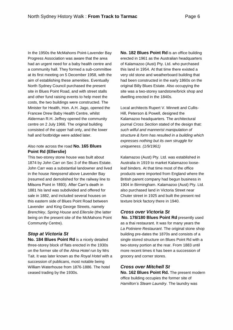
Cross over Mitchell St No. 162 Blues Point Rd. The present modern
office building occupies the former site of
Hamilton‟s Steam Laundry. The laundry was
North Sydney History Walk : From Track to Tarmac Page 7
built about 1905 and demolished in the 1970s. It
was at one time a distinctive landmark on the
North Sydney skyline as it featured a tall brick
chimney which could be seen from miles away.
Hamilton‟s Laundry prior to redevelopment of the
site, 1971.Photograph by Young & Richardson.
(North Sydney Heritage Centre, PF 1255)
Continue walking along Blues Point Rd
Take note of Nos. 149/151 Blues Point Rd
adjoining King George St, a nicely detailed pair
of two-storey red brick shops with four flats
above, built in 1941.
No. 139 Blues Point Rd
Now a thai restaurant but originally built and
operated as the former London store, Willington
and Son, Wholesale and Family Grocers. The
Willington‘s operated the store on the ground
floor and lived upstairs. They also held a liquor
licence and sold wine by the bottle and glass,
the London Store becoming a popular drinking
spot for many of the locals. Walter Willington
and his eldest son Thomas James bought the
land and building from Michael McMahon for
£600 in July 1890. When Walter George
Willington died in 1910 he left the property to his
eldest son Thomas and his wife Grace Louise.
After Thomas J Willington's death in 1928 the
property was left to his widow Grace Louise. She
leased the shop for the next ten years to James
Doble who continued to run the business of
selling groceries and provisions and maintained
the license as a wine merchant. After Grace's
death in the mid-1930s it was sold to Thomas
Nicholls. After his death his widow leased the
premises to McWilliams Wines and they did
away with the general grocery business and
converted it into wine merchants and extended
the bar into a larger wine bar selling exclusively
McWilliams Wines. The latter bought the
property and continued to operate it as a wine
bar. McWilliams sold the premises to Francis
and Agatha Sinclair and in the 1970s it became
the Grape Escape Bar and Restaurant until the
1990s when it changed hands and became the
present Thai Riffic Restaurant.
Walter George Willington outside his store. The
original verandahs and awnings shown in this
1870s view have long since been removed.
(North Sydney Heritage Centre, PF 1056)
Continue along Blues Point Rd Take note of Nos.123-137 Blues Point Rd
comprising a small shopping and café precinct in
Blues Point Road, formerly two groups of two-
storey dwellings. These houses were converted
into shops and cafes in the 1970s. Nos.131-
135 Blues Point Rd were built at the
beginning of 1897, whilst the adjoining houses,
Nos.123-129 Blues Point Rd, are collectively
known as the Hopwood Terrace and were built
North Sydney History Walk : From Track to Tarmac Page 8
in 1910 (note the name and date on the parapet
above the first floor).
Nos. 136-156 Blues Point Rd.
This group of shops/dwellings were built in the
second half of the 19th century to service the
needs of the small McMahons Point community.
Since the 1900s this group of shops have been
occupied by the usual assortment of local
businesses such as grocers, greengrocers,
general stores, bootmakers and shoe repairers,
hairdressers and barbers, confectioners,
chemists and newsagents.
Cross over to Prince St and continue along Blues Point Rd. Turn right at Mil Mil St Note the chimney standing beside the fence at
No. 126 Blues Point Rd. It belonged to a
small cottage built in the 1860s by the
grandfather of Harry Reynolds who was a
waterman on Sydney Harbour, plying his trade
between North Sydney and Circular Quay.
This cottage was also one of the last in the
municipality to have electricity connected in
1976. The Sydney County Council believed that
the house in Blues Point Road, is as far as can
be ascertained, the oldest to have been without
electricity in North Sydney. It is only a three-
room structure, with a disused chimney in the
backyard that was originally used for heating
water.
Continue along Blues Point Rd
heading downhill and cross over French St The Blues Point Hotel is an excellent
example of the inter war functionalist/interwar art
deco style. This two-storey brick building is
curved around the corner of French Street and
features a parapet with brick corbelling, double
hung timber framed windows with horizontal
glazing bars to first floor, a cantilevered awning,
and majolica pattern glazed wall tiling to the
ground floor. The present art deco building
replaced the earlier hotel in 1938 and was
designed by architects, J.E. & E.R. Justelius and
N.D. Frederick.
The first hotel on the site was named the North
Shore Hotel and was most likely built by
publican James Phile about 1864 as it first
appears in the Sands Directory in 1865. Phile
had previously run the St. Leonards Hotel and
Billy Blue Inn. Later publicans of the hotel
include John Blue, Rachael Blue, William Green
and William Kelly.
Cross back over Blues Point Rd to East Crescent St Take note of No.101 Blues Point Rd,
currently a hairdressing salon, but originally one
of a pair of stone houses built before 1869 by
Henry Mohrman. The shopfront was added
around the 1900s. It was used as a butchers
shop for many years.
Cross over East Crescent St This block of flats at No. 36 East Crescent St
were built in 1937 and designed by architect
Charles Leslie-Rounding.
The adjoining pair of stone houses, Nos. 89/91
Blues Point Rd is believed to be one of the
earliest surviving buildings in Blues Point Rd.
The first part of the building was built before
1869 and variously described in Council Rate
Books as a house and shop or dwelling house
and shop or shop, store and dwelling house. A
large increase in the annual value between 1869
and 1870 may indicate substantial building work
occurred at that time. The second part of the
building was erected by the owner Mrs Clewett
about 1878.

North Sydney History Walk : From Track to Tarmac Page 9
North Sydney historian and early Neutral Bay
resident G.V.F. Mann claims that Clewett
operated a dairy farm in that vicinity -
on the hill, where Captain R.F. Pockley owned
many acres.(between East Crescent and Parker
Streets and down to the harbour at Lavender
Bay).
Continue walking down the hill No. 81 Blues Point Rd is the former home of
noted Australian photographer David Moore
(1927-2003). He hired architects Philip Cox &
Partners to design the house for him in 1977 to
incorporate his photographic studio and living
quarters. The home features a landscaped
courtyard separating the studio and living area
and is built on a small site in an area with a
diversity of older residential buildings. The house
won a merit award in category B of the NSW
Building Awards in 1978.
No. 75 Blues Point Rd
Magnolia Cottage is one of a group of
surviving stone houses along this section of
Blues Point Road. It was built about 1877 by
George Adamson. The adjoining pair of two-
storey houses at Nos. 77-79 Blues Point Rd
were also built by Adamson. These replaced an
earlier single storey, two roomed wood and
shingle dwelling house.
Next door, No. 73 Blues Point Rd is another
small stone house built in 1869 for Joseph
Reeves. It was owned from 1874-1985 by the
Trustees for the Estate of Van Der Polder and
then sold to solicitor Llewellyn Russell Jones
who bought the house as an investment
property. Formerly known as Avinon.
Further along the road is Nos. 63/65 Blues
Point Rd, formerly a dwelling house and shop
built in 1872 by John Langford. The first tenant
of the house, Mrs Agnes McNab, bought the
house from him about 1876 and operated a shop
here until her death about 1913.
Continue along Blues Point Rd and cross over Parker St No. 47 Blues Point Rd, variously called
Fairmount or Fairmont. This house, situated high
above the road at the Parker Street intersection
was built in 1880 by John Thomas, a provision
merchant of George Street, Sydney and his wife
Ellen.
Three of their children were married from this
home. After John‘s death of a stroke in 1887 his
wife Ellen moved to their other home, Verona, 1
Parker St, located at the rear of Fairmont. Ellen
sold the house about 1908 to Charles Smith,
who almost immediately sold it again to John
Michael Taylor.
Cross over to West Crescent St Note the sandstone fence and railing now
surrounding No. 58 Blues Point Rd. Formerly
the site of Allington House built in 1871 by Mr
Muston and subsequently sold to James and
Jane Powell by 1879. After their respective
deaths the house was sold to contractor
Nicholas Trevaskis and then to Mrs Alice and
John Trevaskis who leased it out to a
succession of tenants. Mr Kersey subdivided the
property in 1945 and the present house was built
on new lot B.
The old two-storey sandstone Allington House
was demolished to make way for the ‗space-age‘
apartments at the rear (2 West Crescent St).
This building was designed in 1968 by Stan
Symonds for John and Ivy Moore and completed
in 1973. Sandstone from the former house was
reused in landscaping and retaining walls.
Note across the road, Nos. 33-43 Blues Point
Road, a group of houses and flats, some with

North Sydney History Walk : From Track to Tarmac Page 10
garages at street level, built on steeply sloping
blocks above Blues Point Road. These
properties were built on the Pockley Estate
between 1910-1920. Robert Pockley was a
master mariner and captain of various ships
including the Tobago in 1844/45 and Hellespont
in 1854 (Sydney-Melbourne Steam Packet Co.).
Pockley was also the Harbour Master at Port
Jackson when the Dunbar went down off the
heads in 1861. He was for a time the largest
ship owner in tonnage in Australia. He and his
wife raised 12 children at his home Pictonville,
Lane Cove Road, North Sydney before moving
to Killara.
Continue walking down hill towards Blues Point
Nos. 32-36 Blues Point Rd
The Westbridge flats were designed by
architect A.M. Bolot and built by the Urban Co-
Operative Multi-Home Units No. 2 Ltd. in 1947
as an early example of the tenant-ownership
system. Two other co-operative societies were
formed at the same time to build flats in Waruda
Street, Kirribilli and the other in Potts Point.
Westbridge was originally designed as a block of
36 flats, but this was later reduced to 27.
Westbridge occupies the site of the Figtree Inn
and Bayview Cottage. The Figtree Inn was one
of the earliest hotels established in the North
Sydney area, probably built in 1843 by Thomas
Redgrave. The hotel was subsequently operated
by a succession of publicans including William
Montgomery, Thomas Stephens and Archibald
Stephens. Mrs May E. Simpson interviewed for
an article in the Northern Herald on 21 July
1975, was one of the early residents of the area
and moved into the suburb when the Figtree Inn
was still standing. She recalled a story of the
original owner Thomas Redgrave who was quite
an eccentric, “he was married to an aborigine
and whenever he‟d go off in his rowing boat to
the city he‟d lower her down the well”.
The Figtree Inn (right) as it appeared in the
1870s. (Courtesy State Library of NSW)
The Figtree Inn featured in one of Henry
Lawsons‘ poems, The Pub That Lost Its Licence.
Here are the first and last verses of that poem –
The pub that lost its licence
Was very quaint and old;
„Twas built before the railway,
Before the days of gold.
The pub that lost its licence
Was built of solid stone
And good Australian hardwood
In fashion all its own.
The old pub lost it licence,
Not for its sins at all;
But because it was a free house
(They said it was too small).
„Twas let to other people
That grind and grub, and wowse -
They turned it into “lodgings”:
And called it “Fig Tree House”.
(They opened it for Boarders
And called it Figtree House!)

North Sydney History Walk : From Track to Tarmac Page 11
No. 26-28 Blues Point Rd
Site of Belmont built by the estate of Moses
Bell about 1890. The house was acquired by the
developers of Blues Point Tower and
demolished at the end of 1959.
Cross over Rd Henry Lawson Drive named in honour of
much loved former popular Australian writer
Henry Lawson (1867-1922). Henry lived in North
Sydney on many occasions, notably in Euroka
Street. Formerly known as Cliff Avenue, Henry
Lawson Drive was only formed after 1909 when
the cliff was excavated for a tramway loop
servicing the McMahons Point Ferry Wharf.
Turn left into Henry Lawson Dve No. 1/1a Henry Lawson Dve
This house and slipway was formerly associated
with prominent boatbuilder, Reginald Holmes.
His business operated from a number of
different sites in and around Blues Point
including the former Neptune Engineering
Company site at the head of Lavender Bay and
here on the shores of McMahons Point. He was
implicated in the infamous ‗shark arm case‘ of
1935.
Continue to end of Rd McMahons Point Wharf
In 1884 an all-night ferry service operated
between Circular Quay and the north shore
stopping at Milsons Point, McMahons Point and
Lavender Bay. From 1906 Sydney Ferries ran
services at 15 minute intervals and every 10
minutes at peak hour. Whilst Milsons Point was
by far the busiest of North Sydney‘s ferry
wharves, the McMahons Point and Lavender
Bay service was a popular and busy transport
route carrying over 6,000,000 passengers per
annum before the opening of the Bridge. By the
1930s steam ferries were berthed at the Point
and the wharf bustled with activity – coal
loading, water tanks and other infrastructure to
support the steam ferries.
Ferry services were essential to the residents on
the north side, but were also the subject of much
grumbling and controversy. Wharves were often
inadequate, embarking and loading considered
unsafe and fares always in contention.
Passenger services continued to operate
between Circular Quay and McMahons Point on
a trial basis after the opening of the Bridge in
March 1932 to see whether residents of
McMahons Point and Lavender Bay preferred to
travel across the Bridge or on the ferries. Until
October 1932 Sydney Ferries Limited operated a
reduced service to these wharves but
complained of considerable revenue losses and
the fact that Council accepted a tender by
Mr Hegarty to run a ferry service at the wharves
made available by Sydney Ferries. In 1935 the
Manager of the Company sought Council‘s
views on their intention to resume services to
McMahons Point and Lavender Bay, combined
with a new Milsons Point run. Council responded
favourably but warily and asked the Company to
provide assurances that the service would be
permanent and reliable.
Return to Blues Point Rd via Blues Point Reserve Near this intersection stood a cottage owned by
William Blue (Jr). In the late 1860s William
Waterhouse occupied this cottage. The house
was then occupied by a succession of tenants.
Adjacent to the cottage was another stone
building used by various lessees for wharfage
purposes and which eventually became the
North Sydney Council tar depot.
Blues Point Vehicular Ferry Dock
Our house belonged to Sydney Ferry Company
– Number 1 Blues Point Road, right at the very
end of Blues Point Road where the vehicular

North Sydney History Walk : From Track to Tarmac Page 12
ferry used to come in with the horses and carts
before the Bridge was built… Our house was the
only house there … the next lot of this was
where the coke and the clinker and stuff was
piled ready to go on the ferries.
Joan Wakeham, Oral History Interview 1997
Along the foreshore are the remains of the Blues
Point Vehicular Wharf which commenced
operation in 1901 and continued until 1932 when
it was rendered obsolete by the opening of the
Sydney Harbour Bridge. It was originally used to
augment the service to Milsons Point, and it was
the main cross-harbour terminal on the north
side during the construction of the Sydney
Harbour Bridge from 1924-1932.
Ferries traversed the waters between Sydney
and Blues Point before formalised ferry services
were established. Watermen, such as Billy Blue
(for whom the Point is named), offered ferrying
facilities at a price. With a captive audience
these ferrymen plied their trade offering varying
degrees of service - some were noted for their
bad temper and unpleasant manner, others for
extracting unreasonable fares and their boats
were thought to be unsafe and unkempt. Not a
satisfactory situation for a growing township and
the demands for a proper ferry service were
increasing in the 1830s and 1840s. In 1842 a
regular service was established between Blues
Point and Windmill Street, Dawes Point with the
Princess, a steam punt designed to carry
passengers and vehicles. The Princess was
replaced by the Ferry Queen in 1845.
A public wharf was officially gazetted on 10
October 1871 (NSW Government Gazette No
247) in response to deputations made by the
Borough of Victoria. The original wharf was built
on land part dedicated to the public by the crown
and part dedicated to the public by the
subdivision of blues estate.
Under the Borough of Victoria‘s conditions for
leasing the public wharf, they required the
successful lessee to - run a steamboat for the
accommodation of passengers and horse and
carts or other vehicles to and from Sydney—the
steam for passengers to run daily throughout the
year at regular intervals and the last boat to
leave Sydney at 12 o'clock midnight, Sundays
excepted.
Hunt and Greenwell wrote to the Council in
August 1871 expressing a wish “to put a waiting
room at the end of Blues Point Wharf...for the
convenience of passengers by the steamer”.
William Stoddard erected a punt and floating
stage in 1873. Although the wharfage facilities
were extended in 1886 for “the purpose of
establishing a ferry for passengers and vehicular
traffic to and from Sydney”, the Borough
continued its push for better services to its
shores and in 1888 approached the State
Government – to provide suitable
accommodation for the whole of the North Shore
traffic on the Sydney side of the harbour and
more especially for the contemplated ferry at
Blues Point.
Blues Point
Named in honour of William (Billy) Blue who was
granted 80 acres of land here on the north side
of the Port Jackson in 1817 by Governor
Macquarie. He named his grant ‗Northampton
Farm‘.
Billy Blue was probably a Jamaican or West
Indian and was an ex-convict sentenced to
seven years transportation in 1795 for stealing
20lb of raw sugar from a ship, when he was
working as a wharf labourer. He married
Elizabeth Williams in 1805 at St. Philip‘s Church,
Sydney and they lived in the Rocks for a time.
Billy became Sydney‘s first official ferryman in
1807.
North Sydney History Walk : From Track to Tarmac Page 13
William Blue died on 29 May 1834. Between
1838 and 1844 the land inherited by eldest son
William was gradually subdivided. William Blue
junior outlasted his father by only nine years.
Daughter Susannah Blue (Mrs Chuter) and other
son John retained the best part of their
inheritances until their deaths.
Cross over rd Blues Point Tower
At the tip of the point overlooking the harbour
was situated the house known as Gibraltar.
According to G.V.F. Mann in his history of North
Sydney published in 1938:
The building was constructed of wood and stone
and is said to have been erected by a Captain
Meredith over one hundred years ago. Gibraltar
was at one time the home of Captain Norrie, and
later was occupied by the late Mr Richard
Teece. The property was then purchased by Mr
Isaac Ellis Ives -a former Alderman and Mayor of
Sydney- who built on the western side of the
Point a bond for the storage of kerosene.
Isaac Ellis Ives served as an Alderman of City of
Sydney Council, Mayor of Sydney 1896-1897,
and also Member in the Legislative Assembly for
St. Leonards 1885-1889. Ives was born in Great
Waltham, Essex, England in 1839 and arrived in
Sydney in January 1857 under a 3-year
engagement to Tooth & Co. where he worked at
their Kent Brewery. He was appointed manager
of the Argyle Bonded and Free Warehouses for
Messrs Tooth, Mort and Croft (1860-1865), then
for J.S. Mitchell until 1876 when he purchased
the business himself. Ives was a promoter of the
North Shore ferry Company, and a chairman of
that company for a short time. After his death in
1906 at Mosman, Gibraltar was acquired by
Sydney Ferries Limited and the house occupied
by the Company‘s manager, Mr Todd, ―under
whose supervision wharves were erected on the
western front of the Point for the fuelling of the
Company‘s steamers‖. G.V.F. Mann in his 1938
history notes -
after being untenanted for many years it fell into
a state of decay, and was recently demolished.
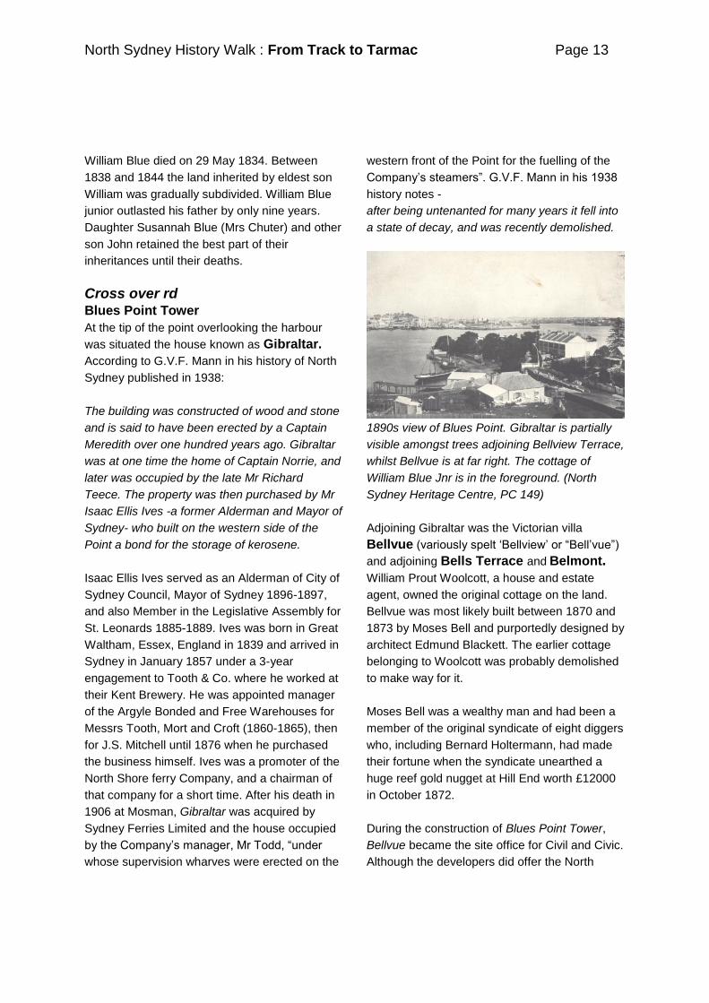
1890s view of Blues Point. Gibraltar is partially
visible amongst trees adjoining Bellview Terrace,
whilst Bellvue is at far right. The cottage of
William Blue Jnr is in the foreground. (North
Sydney Heritage Centre, PC 149)
Adjoining Gibraltar was the Victorian villa
Bellvue (variously spelt ‗Bellview‘ or ―Bell‘vue‖)
and adjoining Bells Terrace and Belmont.
William Prout Woolcott, a house and estate
agent, owned the original cottage on the land.
Bellvue was most likely built between 1870 and
1873 by Moses Bell and purportedly designed by
architect Edmund Blackett. The earlier cottage
belonging to Woolcott was probably demolished
to make way for it.
Moses Bell was a wealthy man and had been a
member of the original syndicate of eight diggers
who, including Bernard Holtermann, had made
their fortune when the syndicate unearthed a
huge reef gold nugget at Hill End worth £12000
in October 1872.
During the construction of Blues Point Tower,
Bellvue became the site office for Civil and Civic.
Although the developers did offer the North
North Sydney History Walk : From Track to Tarmac Page 14
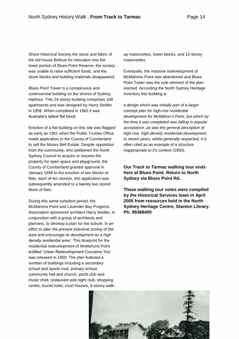
Shore Historical Society the stone and fabric of
the old house Bellvue for relocation into the
lower portion of Blues Point Reserve, the society
was unable to raise sufficient funds, and the
stone blocks and building materials disappeared.
Blues Point Tower is a conspicuous and
controversial building on the shores of Sydney
Harbour. This 24-storey building comprises 168
apartments and was designed by Harry Seidler
in 1958. When completed in 1962 it was
Australia‘s tallest flat block.
Erection of a flat building on this site was flagged
as early as 1951 when the Public Trustee Office
made application to the County of Cumberland
to sell the Moses Bell Estate. Despite opposition
from the community, who petitioned the North
Sydney Council to acquire or resume the
property for open space and playground, the
County of Cumberland granted approval in
January 1958 to the erection of two blocks of
flats, each of ten storeys, this application was
subsequently amended to a twenty-two stored
block of flats.
During this same turbulent period, the
McMahons Point and Lavender Bay Progress
Association sponsored architect Harry Seidler, in
conjunction with a group of architects and
planners, to develop a plan for the suburb „in an
effort to alter the present industrial zoning of the
area and encourage its development as a high
density residential area‟. This blueprint for the
residential redevelopment of McMahons Point
entitled ‗Urban Redevelopment Concerns You‘
was released in 1959. The plan featured a
number of buildings including a secondary
school and sports oval, primary school,
community hall and church, yacht club and
music shell, restaurant and night club, shopping
centre, tourist hotel, court houses, 6-storey walk-
up maisonettes, tower blocks, and 12-storey
maisonettes.
Eventually, the massive redevelopment of
McMahons Point was abandoned and Blues
Point Tower was the sole element of the plan
erected. According the North Sydney Heritage
Inventory this building is
a design which was initially part of a larger
concept plan for high-rise residential
development for McMahon's Point, but which by
the time it was completed was falling in popular
acceptance, as was the general perception of
high-rise, high-density residential development.
In recent years, whilst generally respected, it is
often cited as an example of a structure
inappropriate to it's context (1993).
Our Track to Tarmac walking tour ends
here at Blues Point. Return to North
Sydney via Blues Point Rd.
These walking tour notes were compiled
by the Historical Services team in April
2005 from resources held in the North
Sydney Heritage Centre, Stanton Library.
Ph: 99368400