From RAIL to ROAD F - American Surveyor Magazine · From RAIL to ROAD The point cloud, 360° ......
3
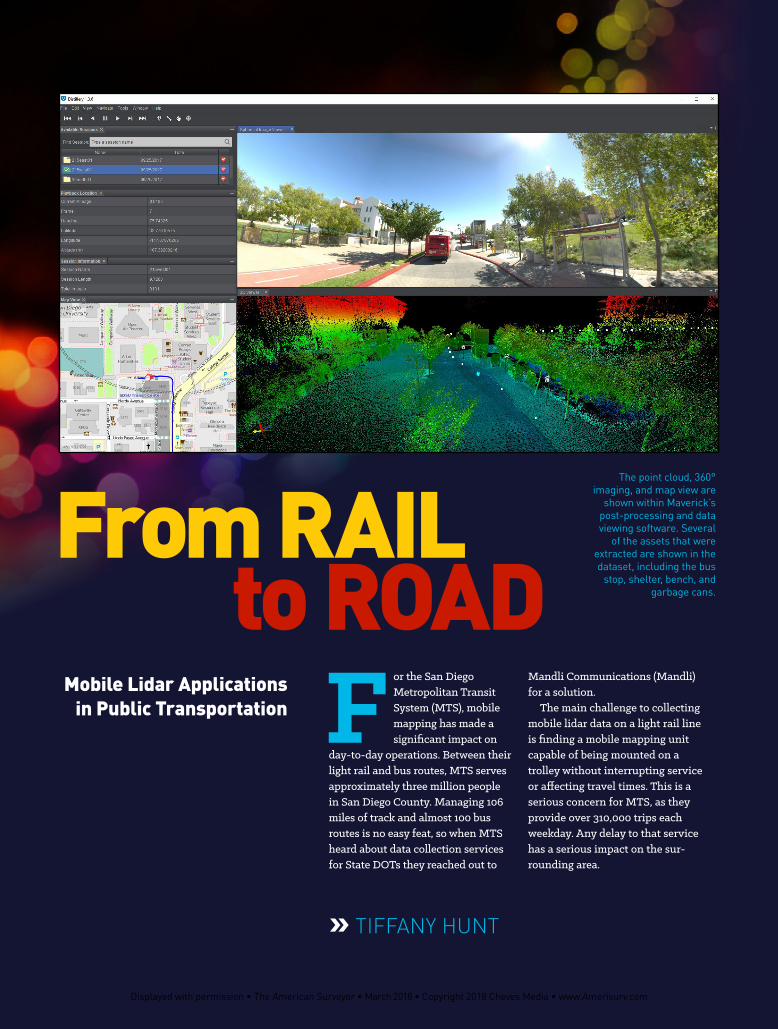
» TIFFANY HUNT F or the San Diego Metropolitan Transit System (MTS), mobile mapping has made a significant impact on day-to-day operations. Between their light rail and bus routes, MTS serves approximately three million people in San Diego County. Managing 106 miles of track and almost 100 bus routes is no easy feat, so when MTS heard about data collection services for State DOTs they reached out to Mandli Communications (Mandli) for a solution. The main challenge to collecting mobile lidar data on a light rail line is finding a mobile mapping unit capable of being mounted on a trolley without interrupting service or affecting travel times. This is a serious concern for MTS, as they provide over 310,000 trips each weekday. Any delay to that service has a serious impact on the sur- rounding area. Mobile Lidar Applications in Public Transportation From RAIL to ROAD The point cloud, 360° imaging, and map view are shown within Maverick’s post-processing and data viewing software. Several of the assets that were extracted are shown in the dataset, including the bus stop, shelter, bench, and garbage cans. Displayed with permission • The American Surveyor • March 2018 • Copyright 2018 Cheves Media • www.Amerisurv.com
-
Upload
nguyenkhue -
Category
Documents
-
view
214 -
download
1
Transcript of From RAIL to ROAD F - American Surveyor Magazine · From RAIL to ROAD The point cloud, 360° ......
» TIFFANY HUNT
F or the San Diego Metropolitan Transit System (MTS), mobile mapping has made a significant impact on
day-to-day operations. Between their light rail and bus routes, MTS serves approximately three million people in San Diego County. Managing 106 miles of track and almost 100 bus routes is no easy feat, so when MTS heard about data collection services for State DOTs they reached out to
Mandli Communications (Mandli) for a solution.
The main challenge to collecting mobile lidar data on a light rail line is finding a mobile mapping unit capable of being mounted on a trolley without interrupting service or affecting travel times. This is a serious concern for MTS, as they provide over 310,000 trips each weekday. Any delay to that service has a serious impact on the sur-rounding area.
Mobile Lidar Applications in Public Transportation
From RAILto ROAD
The point cloud, 360° imaging, and map view are
shown within Maverick’s post-processing and data viewing software. Several
of the assets that were extracted are shown in the dataset, including the bus
stop, shelter, bench, and garbage cans.
Displayed with permission • The American Surveyor • March 2018 • Copyright 2018 Cheves Media • www.Amerisurv.com

Maverick mounted to a commuter train with Mandli’s prototype suction cup mount. The mount is powered by a vacuum pump with an internal backup battery housed within the control box.
Mobile Lidar SolutionThe technology used for MTS is Teledyne Optech’s mobile mapping system, Maverick. The highly portable system combines 360° imaging, high-definition lidar, and an integrated position and orientation system to efficiently collect accurate mobile data. Maverick’s lidar unit collects up to 700,000 data points per second and the 360° camera captures high-resolution images using six high-quality 5-MP sensors. Weighing less than 9 kilograms, Maverick operates in a wide range of conditions and is easily mounted on a variety of platforms.
“With Maverick, we were trying to accomplish three things: bring the price down to remove barriers to entry; remove some of the complexity associated with high-accuracy mapping; and shrink the unit for deployment in different types of applications,” explained Albert Iavarone, Sales Director and Business Unit Manager for Teledyne Optech’s terrestrial products division.
Maverick was chosen for this project because of its portability and flexibility in mounting options: It has its own travel-ing case, meets weight requirements to be checked as airline baggage, and its optional 4-armed vehicle mount attaches to just about any set of roof bars on road
vehicles. For this rail application, Mandli developed a prototype suction cup mount, designed to attach to the windshield of any commuter train. The mount is powered by a vacuum pump with an internal back-up battery housed within the control box.
Mandli first collected lidar data and images for the light rail service with an early prototype of the Maverick in 2013. With the Maverick now available for sale, Maverick operators were asked to return and update MTS’ dataset in May 2016.
Rail Applications Data was collected along 106 miles of track in less than a day. The resulting dataset, viewed in Mandli’s Roadview Workstation software, provided MTS with an accurate GIS inventory of all trackside assets, which allows them to inspect and monitor track condition from the safety of their offices. It also allows MTS to maintain an accurate inventory of assets. “Roadview [Workstation] allows MTS to find, map, and categorize everything along the right-of-way. It’s helped our track team analyze work that needs to be done faster and more efficiently,” said Paul Jablonski, MTS CEO, in a recent article published in Metro Magazine.
While the Track and Wayside depart-ments at MTS were the original groups interested in mobile lidar, other depart-
ments gained interest as they viewed the data and began to see ways it could be utilized for their purposes as well. MTS Rail Training Supervisor Dave Jensen added, “Roadview [Workstation] is a perfect element for the train operator training program. We are just getting into the process of using it. It shows students all the intricacies of the system through a new lens. We can visually show students about defensive driving, what to look for in tough intersections, speed limits through certain areas, and much more. And, do it all from the classroom setting.”
Bus ApplicationsAfter seeing the value in mobile lidar and 360° imagery, MTS requested Mandli return with the Maverick to collect a few pilot routes for the Bus Division in September 2017. The entire collection process took less than a day. For bus applications, transit agencies can use the resulting dataset to perform an inventory of bus stops and other assets along the routes. The imagery will be used to train new bus drivers and bus drivers switching from one route to another. Bus drivers will be able to virtually drive through their assigned route to see obstacles, tight corners, and other potential difficulties.
As early adopters of mobile data collection technologies in the public transportation
» TIFFANY HUNT
to ROAD
Displayed with permission • The American Surveyor • March 2018 • Copyright 2018 Cheves Media • www.Amerisurv.com

industry, MTS plans to continue to utilize mobile data to manage its rail system’s inventory. The agency also has plans to renew its GIS inventory when it begins operations on an 11-mile rail extension up the north coast to UC San Diego in 2021. ◾
Tiffany Hunt has been writing professionally within the transportation industry for three years. As Communications Specialist for Mandli Communications, Tiffany enjoys researching and writing about cutting-edge technology, including advances in lidar sensors and autonomous vehicles.
For the collection of MTS’ bus routes, Maverick was
mounted atop a rental car.
Displayed with permission • The American Surveyor • March 2018 • Copyright 2018 Cheves Media • www.Amerisurv.com