The Historic and Majestic Basilica of Notre-Dame in Montreal, Quebec, Canada

42 FROM MONTREAL TO QUEBEC CITY
Quebec City, the main channel is often used by com-mercial ships. Its minimum width is 244 m. Navigation is open year-round on the St. Lawrence up to the Port of Montreal.
Between Montreal and Sorel, there are two channels for small boats to keep them apart from commercial ship-ping. On the north, the Chenal des Plaisanciers begins at Île Sainte-Thérèse and rejoins the main channel at Lanoraie. Lighted buoys mark this 22-mile-long channel, but most of the leading lights have been removed. The strength of the current ranges from 1.2 to 1.9 knot and the minimum depth is 1.70 m.
The Chenal du Sud is marked by lighted navigational aids and runs along the shore for 7 miles between Longueuil and Varennes. Overhead clearance at the Hyppolite-La-fontaine Bridge is 9.75 m and minimum depth is 1.80 m. The Chenal du Sud runs for 4.5 miles east of the Îles de Contrecoeur. It is marked but unlit and very narrow.
Downriver from Montreal, the river is relatively narrow and flows between a series of low-lying and often very picturesque islands. The north-shore islands between Pointe-aux-Trembles and Repentigny, at the mouth of the Rivière des Prairies, will take you away from the hustle and bustle of the nearby city. The channels between the islands are navigable, but only the channel that runs north of Île à l’Aigle is marked. It will lead you to the Rivière des Prairies.
At Sorel begins the Archipelago of Lake St. Pierre. This delta encompasses a multitude of islands and channels that form an ecological area of prime importance. It has recently been made in 2000 one of UNESCO’s world bios-phere reserves. Lake St. Pierre is the last natural wide-ning of the river and is the largest of the lakes on the St. Lawrence. It’s shallow, 16 miles long, and 6 miles wide. Because of its low-lying shores, you’ll be unable to stop and go ashore before Nicolet. Just before Trois-Rivières, the river narrows again and the shores rise more steeply.
From Montreal to Quebec City
INTRODUCTION___________________________________________
Parc nautique de Contrecoeur
Mic
hel S
acco

43FROM MONTREAL TO QUEBEC CITY
The water level is usually lowest around mid-September. The excep-tionally low levels in 2001 hindered access in many channels to plea-
sure-boat harbours. Contact the har-bour masters to find out the access conditions. The Canadian Hydrogra-phicService provides toll-free reports
on water levels from Montreal to Île aux Coudres. Call 1 877 775- 0790 or visit the website www.cartes.gc.ca.
Distances Montreal/Quebec City 137 nautical milesMontreal/Sorel 37 nautical milesSorel/Trois-Rivières 32 nautical miles
Trois-Rivières/Portneuf 34 nautical milesPortneuf/Quebec City 34 nautical miles
Charts and documents • CHS charts 1310 (new edition 2008), 1311 (new edition 2008), 1312 (new edition 2007), 1313 (new edition 2007), 1314 (new edition 2008), 1315 (new edition summer 2008), 1316.• Sailing Directions: St. Lawrence River, Cap-Rouge to Montréal and Rivière Richelieu, ATL 112, 3rd edition published in 2009.• Sailing Directions: St. Lawrence River, Île Verte to Québec and Fjord du Saguenay, ATL 111, 3rd edition published in 2007.• Canadian Tide and Current Tables Vol. 3.• Atlas of Tidal Currents.
Vessel Traffic Marine Services frequencies • From Montreal to Tracy: Quebec station VHF channel 10.• From Tracy to Saint-Nicolas: Quebec City station VHF channel 13.• From Saint-Nicolas to Quebec City: Quebec City station VHF channel 12.
Water levels
Between Montreal and Trois- Rivières, the speed of the current ranges from 0.5 to 2 knots, depending on the area. Starting at Trois-Rivières, the tide begins to affect water levels, but the flood current becomes apparent only at Deschaillons. The channel narrows between Portneuf and Des-chaillons. This narrowing is called the Richelieu Rapids. It’s a tricky passage where the ebb current often exceeds 5 knots.
Currents and tidesLocation Mean Mean Duration Duration speed of speed of of flood of ebb flood curr. ebb curr. current current
Trois-Rivières 0.0 knot 1.6 knot 0 h 12 h
Batiscan 0.0 knot 2.2 knots 0 h 12 h
Richelieu Rapids 1.0 knot 5.0 knots 2 h 10 h
Portneuf 0.8 knot 2.0 knots 2 h 30 9 h 30
Neuville 1.8 knot 2.6 knots 4 h 8 h
To make the most of the ebb current on your way to Quebec City and to avoid fighting the flood current, care-fully choose your time of departure from Trois-Rivières. When going in the opposite direction from Quebec City, aim to go through the Richelieu Rapids with the flood current. It’s virtually impossible to fight your waythrough these rapids at the peak of the ebb current without a heavy-duty motor, especially if you’re also buc-king the wind.
Planning your route from Trois-Rivières to Quebec City
Speed Trois-Rivières Quebec City departure time departure time
6 knots 8 h before LT LT at Quebec City at Quebec City
10 knots 5 h before LT 1 h 30 before HT at Quebec City at Quebec
15 knots 4 h before LT 30 min before HT at Quebec City at Quebec
44 FROM MONTREAL TO QUEBEC CITY
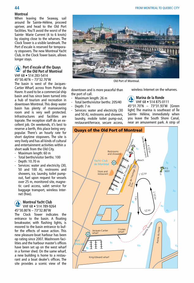
MontrealWhen leaving the Seaway, sail around Île Sainte-Hélène, proceed upriver, and head to the Old Port facilities. You’ll avoid the worst of the Sainte- Marie Current (4 to 6 knots) by staying close to the wharves. The Clock Tower is a visible landmark. The Port d’escale is reserved for tempora-ry stopovers. The new Montreal Yacht Club, in the Clock Tower basin, allows longer stays.
Port d’escale of the Quaysof the Old Port of Montreal
VHF 68 • 514 283-541445°30.40’N – 73°32.70’WThe basin is west of the Jacques- Cartier Wharf, across from Pointe du Havre. It used to be a commercial ship basin and has since been turned into a hub of tourism and recreation in downtown Montreal. This deep waterbasin has plenty of manoeuvring room and is very well protected. Infrastructures and facilities are toprate. The reception staff do an ex-cellent job. On weekends, it’s best to reserve a berth, this place being verypopular. There’s an hourly rate for short daytime stopovers. The site is very lively and has all kinds of cultural and entertainment activities within a short walk from the Old City.- Maximum length: 60 m- Total berths/visitor berths: 100- Depth: 10.70 m- Services: water and electricity (30,
50 and 100 A), restrooms and showers, ice, laundry, toilet pump-out, fuel upon request for vessels over 25 m, monitored site, magne-tic card access, valet service for baggage transport, wireless Inter-net (free).
Montreal Yacht ClubVHF 68 • 514 789-9264
45°30.80’N – 73°32.80’WThe Clock Tower indicates the entrance to the basin. A floating breakwater, with flashing lights, is moored to the basin entrance to buf-fer the effects of wave action. This new pleasure-boat harbour has been op rating since 2007. Washroom faci-lities and the harbour master’s offices have been set up on the west wharf in a former shed. On the same wharf, a new building is home to a restau-rant and a boat dealer’s offices. The site provides a scenic view of the
downtown and is more peaceful than the port of call.- Maximum length: 26 m- Total berths/visitor berths: 205/40- Depth: 7 m- Services: water and electricity (30
and 50 A), restrooms and showers, laundry, mobile toilet pump-out, restaurant/terrace, secure access,
wireless Internet on the wharves.
Marina de la RondeVHF 68 • 514 875-0111
45°31.70’N – 73°31.93’W [Green light] The marina is southeast of Île Sainte- Hélène, immediately when you leave the South Shore Canal, near an amusement park. A strip of
Old Port of Montreal.
King-Edward wharf
Brea
kwat
ers
Beach
Restrooms and showers
Store andrestaurant
Sainte-Marie current
Jacques-Cartierwharf
Cruises wharf
Quays of the Old Port of Montreal

45FROM MONTREAL TO QUEBEC CITY
land protects the basin, which has two entrances. There’s more water in the southern channel and basin (3 m) than in the northern ones (2 m).- Total berths/visitor berths: 175/75- Depth: 2.10 m- Services: water, electricity (15, 30,
and 50 A), gasoline and diesel, restrooms, showers, laundry, toilet pump-out, ice, launching ramp, picnic area with BBQ, wireless Internet.
LongueuilClub nautiquede Longueuil
VHF 68 • 450 646-019745°32.30’N – 73°31.38’W [Green buoy (MT 85)]The boating club has its facilities in two separate basins that look like dug canals. The north basin has a bit more manoeuvring room. The wharves are open to the river and some berths aresubject to wave action. Family atmos-phere.- Total berths/visitor berths/ancho-
rages: 90/ 15/12- Depth: 1.80 m- Services: water and electricity
(30 A), restrooms and showers, laundry, common room, launching ramp, masting crane.
Port de plaisanceRéal-Bouvier
VHF 68 • 450 442-957545°32.67’N – 73°31.34’W [Green buoy (MT 79)]From the commercial channel, a channel marked by private lighted navigational aids will lead you into a large basin that is well protected by a breakwater. The current flows north. Carefully follow the naviga-
tional markers of the main channel by coming from downriver, to avoid the southshore shoals, until you get
to the MT79 buoy. This is a modern and fully equipped pleasure-boat harbour with quality services. The
Port de plaisance Réal-Bouvier.
03
08
2
04
01
34
03
25
Port Sainte-Hélène
Port de plaisanceLa Ronde
Port de plaisance de la Ronde
Montreal Yacht Club.
46 FROM MONTREAL TO QUEBEC CITY
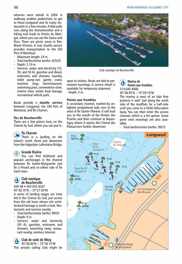
wharves were rebuilt in 2004. A walkway enables pedestrians to get to Vieux-Longueuil and its many res-taurants in a few minutes. A bike path runs along the shoreshoreline and a hiking trail leads to Pointe du Mari-got, where you can see the fauna and flora. There are picnic areas in Parc Marie-Victorin. A river shuttle service provides transportation to the Old Port of Montreal.- Maximum length: 24 m- Total berths/visitor berths: 425/25- Depth: 2.10 m- Services: water and electricity (15,
30, and 50 A), gasoline and diesel, restrooms and showers, laundry, toilet pump-out, gantry crane, machine shop, bar/restaurant, swimming pool, convenience store, marine store, winter boat storage, recreational vehicle park.
Boats provide a shuttle service between Longueuil, the Old Port of Montreal, and Île Charron.
Îles de BouchervilleThere are a few places here, on the Chenal du Sud, where you can put in.
Île CharronThere is a landing on the
island’s south shore just downriver from the Hippolyte-Lafontaine Bridge.
Grande Rivière You can find sheltered and
popular anchorages in the channel between Île Sainte-Marguerite and Île à Pinard and on either side of Île Saint-Jean.
Club nautiquede Boucherville
VHF 68 • 450 655-924745°36.70’N – 73°27.50’WA series of landing stages are insta led in the Chenal du Sud, just across from the old town whose rich archi-tectural heritage is worth a look. Res-taurants and services nearby.- Total berths/visitor berths: 99/20- Depth: 9 m- Services: water and electricity
(30 A), gasoline, restrooms and showers, launching ramp, restau-rant nearby, wireless Internet.
Club de voile de Mézy45°38.00’N – 73°28.15’W
This private sailing club might be
open to visitors. Boats are tied to per-manent moorings. A service wharf is available for temporary stopovers.- Depth: 3 m.
Pointe-aux-TremblesA secondary channel, marked by un-lighted navigational aids, runs to the west of Île Sainte-Thérèse. It will lead you to the mouth of the Rivière des Prairies and then continue to Repen-tigny where it rejoins the Chenal des Plaisanciers further downriver.
Marina dePointe-aux-Trembles
514 645-440045°38.95’N – 73°29.10’WThe marina is west of an islet that protects it well. Sail along the north side of the mudflats for a half-mile until you come to a VEAU bifurcation buoy. You can then enter the access channel, which is a bit upriver. Some perm nent moorings are also avai-lable.- Total berths/visitor berths: 99/15
Haut- fond Longueuil
Haut-fond Longueuil
Dépôts de dragage
Club nautique de Boucherville.
47FROM MONTREAL TO QUEBEC CITY
- Depth: 4 m- Services: water and electricity
(30 A), gasoline, restrooms and showers, toilet pump-out, machine shop, launching ramp, boat sto-rage, marine store, mechanical/fibreglass repair shop.
Marina Bo-Bi-No450 666-1395
45°42.10’N – 73°29.10’WThe facilities are upstream Rivière des Mille-Îles less than a half mile from Bout-de-l’Île. From the AIGLO mid-channel buoy, sail upriver through a channel marked by private navigatio-nal aids that are unlighted but have reflective strips. Landing stages are between the two bridges (highway and rail) on the south shore.- Total berths/visitor berths: 50/5- Depth: 1.80 m- Services: water and electricity (15
A) machine shop, marine store, haulout equipment, boat storage, restrooms and showers, launching ramp, rowboat rental.
Île Saint-Laurent 45°43.55’N – 73°25.85’W
The channel between two islands, Île Saint-Laurent and Île Annexe, is
a sheltered anchorage with 2 m of water. It’s called Le Trou.
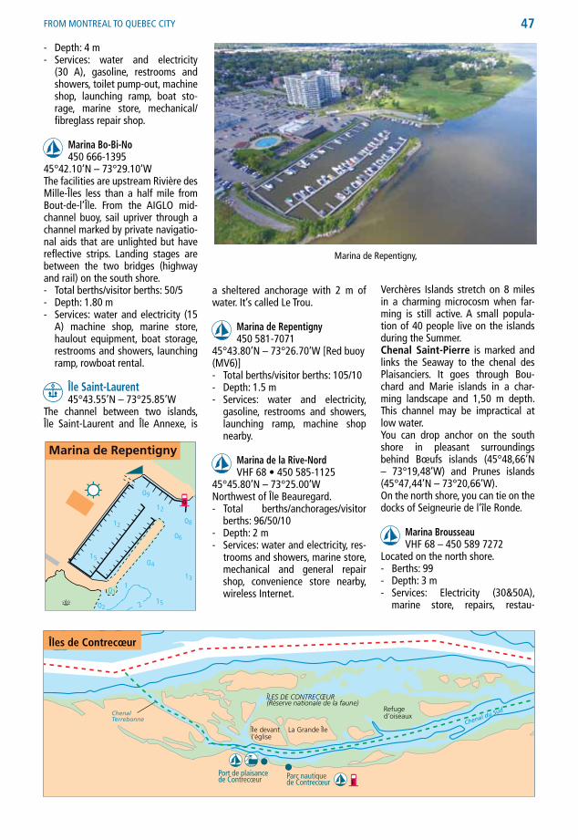
Marina de Repentigny450 581-7071
45°43.80’N – 73°26.70’W [Red buoy(MV6)]- Total berths/visitor berths: 105/10- Depth: 1.5 m- Services: water and electricity,
gasoline, restrooms and showers, launching ramp, machine shop nearby.
Marina de la Rive-NordVHF 68 • 450 585-1125
45°45.80’N – 73°25.00’WNorthwest of Île Beauregard. - Total berths/anchorages/visitor
berths: 96/50/10- Depth: 2 m- Services: water and electricity, res-
trooms and showers, marine store, mechanical and general repair shop, convenience store nearby, wireless Internet.
Verchères Islands stretch on 8 miles in a charming microcosm when far-ming is still active. A small popula-tion of 40 people live on the islands during the Summer.Chenal Saint-Pierre is marked and links the Seaway to the chenal des Plaisanciers. It goes through Bou-chard and Marie islands in a char-ming landscape and 1,50 m depth. This channel may be impractical at low water.You can drop anchor on the south shore in pleasant surroundings behind Bœufs islands (45°48,66’N – 73°19,48’W) and Prunes islands (45°47,44’N – 73°20,66’W).On the north shore, you can tie on the docks of Seigneurie de l’île Ronde.
Marina BrousseauVHF 68 – 450 589 7272
Located on the north shore.- Berths: 99- Depth: 3 m- Services: Electricity (30&50A),
marine store, repairs, restau-
Chenal Terrebonne
Chenal du Sud
Parc nautique de Contrecœur E
Port de plaisance de Contrecœur
ÎLES DE CONTRECŒUR(Réserve nationale de la faune)
Îles de Contrecœur
La Grande ÎleÎle devantl’église
Refuge d’oiseaux
Marina de Repentigny,

48 FROM MONTREAL TO QUEBEC CITY
Éclu
se d
e Sa
int-L
ambe
rt
Rapi
des
du M
oulin
ÎLES
DE S
OREL
Lano
raie
Parc
nau
tique
de C
ontre
cœur
Port
de p
laisa
nce
de C
ontre
cœur
Sain
t-Sul
pice
Mar
ina
Brou
ssea
u
Verc
hère
s
Port
de p
laisa
nce
Réal
-Bou
vier
Club
nau
tique
de
Long
ueui
l
Mar
ina
de La
Ron
de
Yach
t-Clu
b de
Mon
tréal
Port
d’es
cale
du
Vieu
x-Po
rt de
Mon
tréal
Mar
ina
Bo-B
i-No
Mar
ina
dePo
inte
-aux
-Tre
mbl
es
From
Mon
tréa
l to
Sore
l
Mar
ina
de la
Rive
-Nor
d
Mar
ina
de
Repe
ntig
ny Vare
nnes
Club
nau
tique
de
Méz
yCl
ub n
autiq
ue d
e Bo
uche
rvill
eÎLE
DE
MON
TRÉA
L
ÎLE S
AINT
E-TH
ÉRÈS
E
ÎLES
DEVA
RENN
ES
ÎLES
DEVE
RCHÈ
RES
Sain
t-Lam
bert
LockÎLE
S DE
BOUC
HERV
ILLE
Rivière R
ichelie
u
Riviè
re d
es M
ille Îl
es
Rivière
des P
rairi
esL’ïle
-des
-Mou
lins
hist
oric
sit
e
MONTR
EAL H
ARBOUR
Papi
neau
dam
(n
o lo
ck)
Ove
rhea
d cl
eara
nce
5,60
m
MA
IN C
HANNEL
harb
our
MAIN CHANNEL
Sore
l
Sore
l-Tra
cy
ARCH
IPEL
AGO
OF
LAKE
ST.
PIER
RE

49FROM MONTREAL TO QUEBEC CITY
rant, swimming pool, pump-out, launching ramp.
VerchèresA small basin for local boaters.
No services.Depht: 1,20 m to 1,50
ContrecoeurThe Îles de Contrecoeur, a series of low-lying islands, are a national wildlife area. You cannot land here, but you may drop anchor near the large beds of aquatic plants. Two marinas and a public wharf are in this area. The islands provide good protection. To access the islands from upriver, start at the M51 buoy and enter the na row but marked Che-nal Terrebonne. To access them from downriver, start at the M19 buoy and enter the Chenal Sud, which is less constricted than the other one and is marked by unlighted navigational aids.
Public wharf45°51.50’N – 73°14.45’W
The wharf now has a rock-fill em-bankment and landing stages where you can put in for a maximum of 2 h. The site is attractive and in the heart of town. Port de plaisance
de ContecoeurVHF 68 • 450 587-256945°51.70’N-73°14.40’WJust east of the public wharf, right in the town centre and near services.- Total berths/visitor berths: 80/10- Depth: 4 m- Services: water and electricity, re
trooms and showers, restaurant, toilet pump-out, gasoline nearby, mechanic on call, sea kayak rental, launching ramp.
Parc nautiquede Contrecoeur
VHF 68 • 450 587-549545°51.80’N-73°13.88’WJust east of the preceding marina.- Total berths/visitor berths: 60 4/6- Depth: 4 m- Services: water and electricity,
gasoline, restrooms and showers, toilet pump-out, mechanic on call.
Parc nautique de Contrecoeur
Port de plaisance de Contrecoeur

50 FROM MONTREAL TO QUEBEC CITY
2
52
5
22
2
2
5
5
2
From
Sor
el t
o D
esch
aillo
ns
ÎLES
DE
SORE
L
Loui
sevil
le
Club
Mul
tivoi
le
Mar
ina
deTr
ois-
Riviè
res
Pont
La
viole
tteCl
ub n
autiq
ue d
e la
Bat
ture
de
Nico
let
LAC
SAIN
T-PI
ERRE
Cham
plai
n
Port
de B
écan
cour
(por
t de
com
mer
ce)
Halte
nau
tique
Sain
te-A
ngèl
e-de
-Lav
al
Mar
ina
Villa
ge
Batis
can
Les B
ecqu
ets
Club
nau
tique
d’Es
chai
llons
Rivièr e Saint-M
aurice
Riviè
re
Sain
te-A
nne
52
5
2
From
Des
chai
llons
to
Que
bec
City
Club
nau
tique
d’Es
chai
llons
Gron
dine
s
Parc
récr
éona
utiq
uede
Por
tneu
f
RAPI
DES
RICH
ELIE
U
Club
nau
tique
Vauq
uelin
Pont
de
Québ
ec
Mar
ina
dela
Cha
udiè
re
Parc
nau
tique
Lévy
Mar
ina
duPo
rt de
Qué
bec
Yach
t Clu
bde
Qué
bec
Riviè
re au
x Pom
mes
Riviè
reCh
audi
ère
51FROM MONTREAL TO QUEBEC CITY
Chenal du NordAbout a mile downriver from the Tracy thermal power station are unlighted buoys that indicate the channel entrance, a mile upriver from Île aux Foins. The channel is no longer marked further downriver. The Marina l’Émerillon and then the Club nautique de Berthier are loca-ted across from Île du Mitan in 4 m of water. They have a few berths for
visitors in a nice setting and with the usual services.
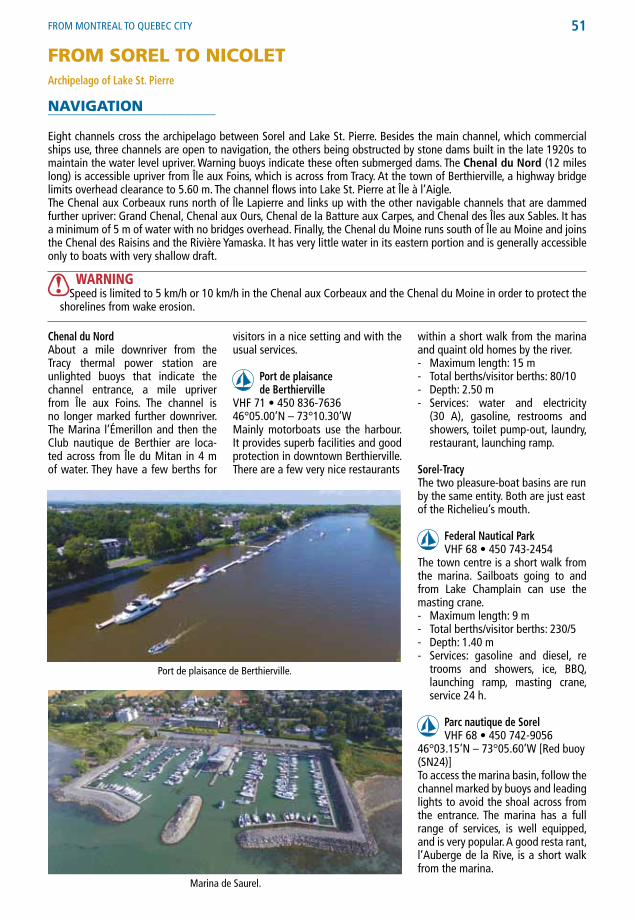
Port de plaisancede Berthierville
VHF 71 • 450 836-763646°05.00’N – 73°10.30’WMainly motorboats use the harbour. It provides superb facilities and good protection in downtown Berthierville. There are a few very nice restaurants
within a short walk from the marina and quaint old homes by the river.- Maximum length: 15 m- Total berths/visitor berths: 80/10- Depth: 2.50 m- Services: water and electricity
(30 A), gasoline, restrooms and showers, toilet pump-out, laundry, restaurant, launching ramp.
Sorel-TracyThe two pleasure-boat basins are runby the same entity. Both are just eastof the Richelieu’s mouth.
Federal Nautical ParkVHF 68 • 450 743-2454
The town centre is a short walk from the marina. Sailboats going to and from Lake Champlain can use the masting crane.- Maximum length: 9 m- Total berths/visitor berths: 230/5- Depth: 1.40 m- Services: gasoline and diesel, re
trooms and showers, ice, BBQ, launching ramp, masting crane, service 24 h.
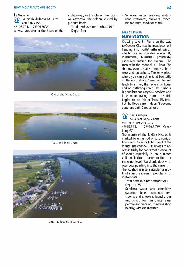
Parc nautique de SorelVHF 68 • 450 742-9056
46°03.15’N – 73°05.60’W [Red buoy(SN24)]To access the marina basin, follow thechannel marked by buoys and leadinglights to avoid the shoal across from the entrance. The marina has a full range of services, is well equipped, and is very popular. A good resta rant,l’Auberge de la Rive, is a short walk from the marina.
Archipelago of Lake St. Pierre
NavIgaTION____________________________
Eight channels cross the archipelago between Sorel and Lake St. Pierre. Besides the main channel, which commercial ships use, three channels are open to navigation, the others being obstructed by stone dams built in the late 1920s to maintain the water level upriver. Warning buoys indicate these often submerged dams. The Chenal du Nord (12 miles long) is accessible upriver from Île aux Foins, which is across from Tracy. At the town of Berthierville, a highway bridge limits overhead clearance to 5.60 m. The channel flows into Lake St. Pierre at Île à l’Aigle.The Chenal aux Corbeaux runs north of Île Lapierre and links up with the other navigable channels that are dammed further upriver: Grand Chenal, Chenal aux Ours, Chenal de la Batture aux Carpes, and Chenal des Îles aux Sables. It has a minimum of 5 m of water with no bridges overhead. Finally, the Chenal du Moine runs south of Île au Moine and joins the Chenal des Raisins and the Rivière Yamaska. It has very little water in its eastern portion and is generally accessible only to boats with very shallow draft.
FROM SOREL TO NICOLET
WARNING Speed is limited to 5 km/h or 10 km/h in the Chenal aux Corbeaux and the Chenal du Moine in order to protect the
shorelines from wake erosion.
Port de plaisance de Berthierville.
Marina de Saurel.

52 FROM MONTREAL TO QUEBEC CITY
- Maximum length: 18 m- Total berths/visitor berths: 250/10- Depth: 1.50 m- Services: water and electricity (15,
30, and a few 50 A), gasoline and diesel, toilet pump-out, restrooms and showers, laundry, swimming pool, ice, BBQ, bike loan, launching ramp, marine store nearby, service 24 h.
Sainte Anne-de-Sorel46°03.60’N - 73°04.10’W
A public wharf and a pier form a smallbasin. At the end of the basin is a launching ramp. The north side of the wharf has 2 m of water but is very exposed to waves. Less than 1 m of water in the basin.
La Halte des 103 îles46°03.90’N73°01.80’W
[Green buoy (SN11)]At the entrance to the Chenal du Moine. Not much manoeuvring roomin the basin. It’s a fairly lively recre-ational/tourism complex.- Total berths/visitor berths: 99/30- Depth: 1.50 m to 2 m- Services: water and electricity (15
A), gasoline, diesel, propane, res-trooms and showers, toilet pump-out, laundry, machine shop, bar, restaurant, convenience store, swimming pool, spa, launching ramp, boat rental.
Stopovers in the archipelagoThe archipelago is a unique natural environment that has retained its wild nature. The many marshlands and the large beds of aquatic plants are home to plenty of seabird colo-nies. The current is weaker in the secondary channels than in the main channel.
Baie de l’île de Grâce 46°06.20’N – 73°00.20’W
This magnificent anchorage is very well protected in a large bay surroun ded by aquatic vegetation. You can enter via the Chenal aux Corbeaux. The channel is narrow and very shal-low, but the mud bottom will not harm the keel of your boat.
Île aux Sables 46°07.15’N – 73°00.40’W
By sailing around the east end of Île de Grâce, you’ll enter the Grand Che-nal—the natural channel that used to handle 85% of the river’s water flow. It’s wide and deep. You can go through it with a sailboat. South of Île aux Sables, just east of a small island whose name is not on the chart, you can drop anchor in 1.80 m of water in attractive surroundings.
Île Moras (wildlife area)
Parc nautique de Sorel-Tracy
Sorel-TracyParc nautique Regard-sur-le-Fleuve
152 12
2
222
22
Île MadamePourvoirie du lac Saint-Pierre450 836-7056
46°06.70’N – 73°04.50’WA wise stopover in the heart of the
archipelago, in the Chenal aux Ours. An attractive site seldom visited by ple sure boats. - Total berths/visitor berths: 45/10- Depth: 3 m
- Services: water, gasoline, restau-rant, restrooms, showers, conve-nience store, rowboat rental.
LAKE ST. PIERRENavIgaTION____________________________Crossing Lake St. Pierre on the way to Quebec City may be troublesome if heading into north/northeast winds, which toss up sizeable waves. By midsummer, bulrushes proliferate, especially outside the channel. The current in the channel is 1 knot. The shallow waters make it impossible to stop and go ashore. The only place where you can put in is at Louisville on the north shore. A marked channel leads to a river, the Rivière du Loup, and an outfitting camp. The harbour is good but has very few services and little manoeuvring room. The tide begins to be felt at Trois- Rivières, but the flood current doesn’t become apparent until Deschaillons.
Club nautiquede la Batture de Nicolet
VHF 71 • 819 293-691246°15.54’N – 72°39.50’W [Green buoy (S9)]The mouth of the Rivière Nicolet is marked by unlighted private naviga-tional aids. A sector light is east of the mouth. The channel silts up easily. Ac-cess is tricky for boats that draw a lot of water, especially in late summer. Call the harbour master to find out the water level. You should dock with your bow pointing into the current.The location is nice, suitable for mul-tihulls, and especially popular with motorboats.- Total berths/visitor berths: 65/10- Depth: 1.75 m- Services: water and electricity,
gasoline, toilet pump-out, res-trooms and showers, laundry, bar and snack bar, launching ramp, permanent mooring, machine shop nearby, wireless Internet.
53FROM MONTREAL TO QUEBEC CITY
Chenal des îles au Sable.
Baie de l’île de Grâce.
Club nautique de la batture.
54 FROM MONTREAL TO QUEBEC CITY
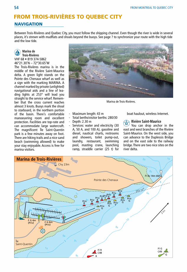
Marina deTrois-Rivières
VHF 68 • 819 374-586246°21.30’N – 72°30.65’WThe Trois-Rivières marina is in the middle of the Rivière Saint-Maurice delta. A green light stands on the Pointe des Chenaux wharf as well as a sign with the marking MARINA. A channel marked by private (unlighted)navigational aids and a line of lea-ding lights at 253° will lead you straight to the service wharf. Remem-ber that the cross current reaches almost 3 knots. Buoys mark the shoal to starboard, in the northern portion of the basin. There’s comfortable manoeuvring room and excellent protection. Facilities are top-rate and can accommodate large watercraft. The magnificent Île Saint-Quentin park is a few minutes away on foot. There are hiking trails and a nice sand beach (swimming allowed) to make your stay enjoyable. Access is free for marina visitors.
- Maximum length: 43 m- Total berths/visitor berths: 280/30- Depth: 2.30 m- Services: water and electricity (30
A, 50 A, and 100 A), gasoline and diesel, nautical charts, restrooms and showers, toilet pump-out, laundry, restaurant, swimming pool, masting crane, launching ramp, straddle carrier (25 t) for
boat haulout, wireless Internet.
Rivière Saint-Maurice You can drop anchor in the
east and west branches of the Rivière Saint-Maurice. On the west side, you can advance to the Duplessis Bridge and on the east side to the railway bridge. There are two nice sites on the river delta.
NavIgaTION____________________________
Between Trois-Rivières and Quebec City, you must follow the shipping channel. Even though the river is wide in severalplaces, it’s strewn with mudflats and shoals beyond the buoys. See page ? to synchronize your route with the high tideand the low tide.
FROM TROIS-RIvIÈRES TO QUEBEC CITY
Marina de Trois-Rivières
Y
Y
Marina de Trois-Rivières.

55FROM MONTREAL TO QUEBEC CITY
Marina deTrois-Rivières
VHF 68 • 819 374-586246°21.30’N – 72°30.65’WThe Trois-Rivières marina is in the middle of the Rivière Saint-Maurice delta. A green light stands on the Pointe des Chenaux wharf as well as a sign with the marking MARINA. A channel marked by private (unlighted)navigational aids and a line of lea-ding lights at 253° will lead you straight to the service wharf. Remem-ber that the cross current reaches almost 3 knots. Buoys mark the shoal to starboard, in the northern portion of the basin. There’s comfortable manoeuvring room and excellent protection. Facilities are top-rate and can accommodate large watercraft. The magnificent Île Saint-Quentin park is a few minutes away on foot. There are hiking trails and a nice sand beach (swimming allowed) to make your stay enjoyable. Access is free for marina visitors.- Maximum length: 43 m- Total berths/visitor berths: 280/30- Depth: 2.30 m- Services: water and electricity (30
A, 50 A, and 100 A), gasoline and diesel, nautical charts, restrooms and showers, toilet pump-out, laundry, restaurant, swimming pool, masting crane, launching ramp, straddle carrier (25 t) for boat haulout, wireless Internet.
Rivière Saint-Maurice You can drop anchor in the
east and west branches of the Rivière Saint-Maurice. On the west side, you can advance to the Duplessis Bridge and on the east side to the railway bridge. There are two nice sites on the river delta.
Halte nautique Saint-Angèle(819 222-5151) is across from Trois Rivières in a small basin that is shel-tered on its west side by an old ferry wharf. Depth: 1.50 m.
WARNING Richelieu Rapids
Between Grondines and Portneuf, the marked channel measures only 250 m wide at its narrowest point. You’ll pass by commercial ships. The distance between the two dry banks is around 450 m. Leading lights will guide you through this winding channel where any deviation will take you into rocks. The ebb current lasts 10 hours and the flood current only two hours. The ebb current reaches up to 8 knots at spring tides and the flood current is weak. The current can generate choppy water and eddies. When the wind blows from the northeast, the area is subject to some choppiness. See page ? to plan your route.
Champlain46°26.40’N – 72°20.40’W
A public wharf poorly protected from the waves. To be used only in emer-gencies.
Marina Village Batiscan VHF 71 • 418 362-2722
46°31.20’N – 72°13.00’W [Red buoy (D62)]Starting at the D62 buoy, a narrow channel, marked by unlighted private navigational aids and a line of lea-ding lights at 274°, will lead you to the river. Take depth soundings in the river’s entrance channel at low tide. The facilities are on the north shore less than a half-mile upriver. There’s enough room for manoeuvring co fortably. The natural surroundings are attractive.- Total berths/visitor berths: 75/25- Depth: 2.70 m- Services: water and electricity,
gasoline, restrooms and showers, toilet pump-out, restaurant, ter-race, swimming pool, campground, launching ramp.
Club nautique d’EschaillonsVHF 68 • 819 292-3368
46°33.87’N - 72°06.20’W [Red buoy (D29)]Private lights on the ends of the wharf and the floating breakwater indicate a small basin west of the public wharf. The entrance is at the west end of the wharf. The basin is
2
5
Club nautiqueD’Eschaillons
210908
1806
4242
28
39
16
81
F Y (Priv) F R
(Priv)
Fl G 4s 11m
Public Wharf
Marina Village Batiscan.
Club nautique D’Eschaillons.

56 FROM MONTREAL TO QUEBEC CITY
protected from the wake of passing ships by a flo ting breakwater and a rock-fill embankment. Nonetheless, expect your boat to pitch and roll a little. The site is attractive.- Total berths/visitor berths: 30/7- Depth: 2 m at low tide- Services: water and electricity,
gasoline (regular and super), restrooms and showers, toilet
pumpout, laundry, restaurant, launching ramp. Beach nearby.
Grondines46°35.15’N – 72°02.40’W
There is a small basin with a few lan-ding stages and a launching ramp between the public wharf to the east and a pier to the west. No recent data on water depths.
Marina de PortneufVHF 68 • 418 286-2263
46°40.85’N – 71°52.65’WA red light stands at the end of a piera half-mile long. The entrance chan-nel is northeast of the pier, between two rock-fill embankments. A white pr vate light is at the end of the east breakw ter. The basin has excellent protection and enough room to ma-noeuvre in comfortably. The facilities are very nice. The harbour master’s office has a cosy lounge and a res-taurant dining room with a beautiful view of the river. You can borrow a bike for going into town to buy gro-ceries.- Maximum length: 21 m- Total berths/visitor berths: 65/10- Depth: 2.70 m at low tide- Services: water and electricity (15
and 30 A), restrooms and showers gasoline and diesel, bar, restau-rant, laundry, toilet pump-out, launching ramp, wireless Internet.
NeuvilleClub nautique VauquelinVHF 68 • 418 876-2185
46°41.25’N – 71°33.80’W [Yellowbuoy (Vauqu)]A line of leading lights at 321° will guide you into the basin from the lighted Vauqu buoy (private). A red light is at the end of the eastern rock-fill embankment. A landing stage sec-tion has been added in the eastern portion of the basin. The protection is good and the facilities decent. A shi-pyard, Passion Marine, is on-site and pr vides all routine repairs.- Maximum length: 13.70 m- Total berths/visitor berths: 106/16 - Depth: 2 m- Services: water and electricity,
gasoline and diesel, restrooms and showers, toilet pump-out, laundry, launching ramp, boat-building and boat-repair shop, haul-out equip-ment, masting post, wireless Inter-net.
Marina de Portneuf.
Marina de Portneuf
Ru
Public
04
03 08
15
16
24
17
03
07
9 128
04
09
78
88
15
35
37
71
42
8636
1

57THE OTTAWA RIVER
Boatyard
Club nautique Vauquelin.

58 FROM MONTREAL TO QUEBEC CITY
Marina de la Chaudière VHF 68 • 418 839-7939
46°44.75’N -–71°16.75’W [Red buoy(QC2)]This marina is on the south shore, justdownriver from the Quebec Bridge onthe mouth of the Rivière Chaudière.Few berths at the wharf.- Total berths/visitor berths/ancho-
rages: 20/5/55- Depth: 3 m- Services: water and electricity, res-
trooms and showers, launching ramp.
Yacht-Club de Québec VHF 68 • 418 681-4617
46°46.90’N –71°13.85’W [Whitebuoy]A white private boat buoy (yellow light) indicates the entrance channel. A line of leading lights at 299° will lead you between the two breakwa-ters. Lights are at the ends of the breakwaters, yellow on the east end, white on the west end. The basin is very well protected. The ser-vice wharf is to starboard when you enter. Services and infrastructures are of very goodquality in a comfortable and we coming setting. The Boulet Leme-lin shipyard and marine store are nearby. The Yacht-Club de Québec is one of North America’s oldest yacht clubs.- Maximum length: 20 m- Total berths/visitor berths: 300/15- Depth: 2.50 m at low tide- Services: water and electricity,
gasoline and diesel, restrooms and showers, toilet pump-out, laundry, bar, restaurant, swim-ming pool, launching ramp for members only, masting crane, wireless Internet.
NavIgaTION____________________________
The ebb current, together with a strong north/northeast wind can make the water unpleasantly choppy near the Quebecbridges. The flood current lasts around 5 h at Quebec City versus 7 h for the ebb current. At the Quebec Bridge, the St. Lawrence is less than a half-mile wide.
At Quebec City, pleasure boaters will find quality boating infrastructures and all specialized services they may need: shipyard, mechanics, electronic technicians, marine stores, and sailmakers.
QUEBEC CITY aREa
Plag
e
Chantier naval BL Yacht
Grue de mâtage
(Priv
) F R
5m
(Priv
) F R
8m
Iso 2s 4m (Priv)
F Y 5m (Priv)
53
45
G
14
SP
G 3
27
26
41
3429
35
61
5747
Marina de la Chaudière.

59FROM MONTREAL TO QUEBEC CITY
Parc nautique Lévy VHF 68 • 418 833-9421
46°47.50’N – 71°11.9’WFixed lights are on the east breakwater. The entrance channel is just right of the blue light. The entrance is pa tially obstructed by a landing stage that is used to deploy a boom in the event of an oil spill. The basin is well pro-tected. This pleasure-boat harbour is fully equipped and
provides good services in a pleasant atmosphere. A bike loan service will let you go for a spin on the bike path that runs by the river. Naviclub, a marine store, is in Lévis. Mobile units provide mechanical and fibreglass repair services.- Maximum length: 13.75 m- Total berths/visitor berths: 225/30- Depth: 3 m at low tide- Services: water and electricity (15A and 30 A), gasoline
and diesel, restrooms and showers, toilet pumpout, laundry, restaurant, launching ramp, haul-out equip-ment, wireless Internet.
Yacht-Club de Québec.
Parc nautique Lévy.

60 FROM MONTREAL TO QUEBEC CITY
Port of Québec marina.
Sailing school
Parking
Large yachts docks
Marine store
Pilot’s house
Lay-to-wharf
Drawbridge
Lock
Old Port Interpretation Center
Crane
Port of Quebec marina
Harbour Master
Port of Quebec marinaVHF 71 • 418 648-2233
46°49.15’N – 71°11.9’WBlue fixed lights on each side of the wharf indicate the entrance to Louise Basin. You must go through a lock to enter the pleasure-boat basin. East ofthe lock is a lay-to wharf. The lock operates from 7 a.m. to half past mi night. The lock operator can be rea-ched on channel 71. This large basin
has plenty of manoeuvring room. There are seven landing stages for large vessels 100 feet long or over, with electricity (100 A , 240 V and 208V). The Global Marine marine store is a short walk away. Service and facilities are first-rate. The ma-rina provides a magnificent view of the historic district and is only a few minutes away on foot from the Old Quebec.
- Maximum length: 60 m- Total berths/visitor berths: 415/100- Depth: 3.10 m to 7 m- Services: water and electricity (30,
50, and 100 A), gasoline and die-sel, restrooms and showers, toilet pump-out, laundry, bar, restaurant, terrace, BBQ, swimming pool, launching ramp, straddle carrier, masting crane, wireless Internet.