From airfield to aerotropolis - central2013.eu · From airfield to aerotropolis. A Central European...
16
From airfield to aerotropolis A Central European perspective on airport led economic development
Transcript of From airfield to aerotropolis - central2013.eu · From airfield to aerotropolis. A Central European...

From airfield to aerotropolisA Central European perspective on airport led economic development

Dear Partners,The airLED project substantially contributes to the spectacu-lar development of our regions. Project partners can be de-scribed as many aircraft flying in a formation, each having its unique story to tell.
We never lose sight of this relationship between us, because we know that this is one of the most essential areas for the development of our region. One of the most important mes-sages of the airLED project implemented through the Central European Programme and co-financed by the European Un-ion and our country is that we can help and share our expe-riences with each other, and make our own decisions about our own affairs.This is what the airLED project is about. AirLED is about thinking together, working together and suc-ceed together.The airLED project is about creating a solid financial and pro-fessional background for an integrated economic develop-ment strategy.
The objective: was to create good practices, information bases, and our own treasure chests together as part-ners, of which everybody will take what best suits their needs, and use the methods, technological solutions, planning processes which they currently need.
As a Lead Partner, together with our domestic and international partners, we have come up with and laid the foundation for developments in airport catchment areas, which will in years to come bring innovative, compre-hensive changes and improve living standards.
The implementation of the airLED project over the years is one of the main token of the economic innovation of BUD Airport and its catchment area, and hopefully that of the other participating regions as well, and at the same time, it also serves as a guarantee for the universal and continuous development.
It is my personal experience that the aldermen of our neighbouring town of Vecsés, Mazovia in Poland, the Slovenian Gorenjska and the Italian Emilia-Romagna feel the same, so every aspect of our joint efforts is not only about us, but our partners as well. About the common past, the life we lead and the future the outlines of which are already visible: the building of Airport Cities.
I would like to thank all experts, project managers, international and domestic professionals for their work.
Attila Ughymayor of District XVIII of Budapest
Dear Partners,The participation of Mazovia Voivodeship in the airLED project and in many other international projects is an important point of integrated regional development policy, which is implemented for many years and based on dia-logue between the stakeholders. The activities undertaken are re-flected in the strategic documents of the region, a coherent vision of area and clearly defined of goals, which determine the developmen-tal processes of the region related to the civilizational challenges of XXI century.
airLED project refers to areas with great potential where the Airport
City can come to reality. It focuses attention on the development of areas near airports (catchment airport areas) by strategic planning. Surroundings of airports es-pecially those international has enormous potential, which gives the opportunity to the investment of public - private partnership and becomes a stimulus to econom-ic development, creating an attractive place for investors. Warsaw Modlin Airport, Airport City to be developed could introduce a new value the cultural value in the form of Modlin Fortress, which may contribute to identity and will be specific point concerning the uniqueness of the location in Europe.
airLED project is a pioneer project in Europe. It provides a platform for exchange of experiences for all participants who are involved in building strategies and develop-ment plans of airport catchment areas. The achieved project results in international terms are important from the point of view of the implementation primary objective of European integration which is to stimulate socio-economic development and to ensure sustainable development of the whole EU area.
I hope that the activities taken and the cooperation will serve to build and strengthen the economic position of the land around airports in the regions.
Adam Struzik Marshal of Mazovia Voivodeship

Introduction:A well-planned airport that is integrated with the surrounding are-as can provide an economic boost to an entire region. Four Cen-tral European regions have been involved in the airLED project tocome up with a long-term development concept for economical-ly isolated airport areas. The project focused on assessing the development of “Airport Cities” in Europe, analysing the needs of “Airport Cities” and the areas around them, and supporting designated bodies that represent major stakeholders in the de-velopment.
The main objective was to create economic development plans that can be integrated into the local, regional or national plans for the next EU budget period. Secondly, to enable the regions involved to attract investment that can create jobs and help localurban development, by providing them tools, studies – a com-monly elaborated know-how. For the integrated development ofairports and the areas around tasks and responsibilities neededto be divided between the cities in the area.
A brief description of the airLED project The Local Government of Budapest District 18 decided to come up with a long-term development concept of airport areas to ad-dress the socio-economic impacts of globalisation and the rap-idly changing economic environment. However, the city realised that the best way to tackle such a complex issue is to join forceswith regions facing similar challenges and share the view that airport areas are an opportunity to increase competitiveness and
cohesion of the local, but nevertheless the whole Central Euro-pean region.Four regions - Budapest (HU), Mazovia (PL), Gorenjska (SI), Emil-ia Romagna (IT) - formed the airLED partnership in order to cre-ate a strategic framework along the vision of becoming an Airport City. Each region is represented by public bodies and knowledge institutions.
The process: from A to ZTThe specific objective of airLED was to help integrated polycen-tric development planning in Central Europen airport catchment areas with the view of becoming Airport Cities.
Strategy building had three pillars:
(1) Logistics and transport;(2) Spatial development, environment and architecture and(3) Business and investment development.
airLED investigated and offered strategic solutions to use the un-tapped socio-economic potential of airport areas, actively involvinglocal, regional and national stakeholders. The objective of the project was achieved through a number of core activities: making an EU state-of-art report on Airport City de-velopment; status quo analysis for each region. Strategy building was implemented by the intensive process of Open Living Labs with the participation of all key stakeholders in the various aspects of development. The project put great emphasis on the coopera-tion between urban, sub-urban and regional players who have a stake in regional and economic development by facilitating coop-eration between them taking a bottom-up approach to strategic
planning. As part of this process, cases of the formulating trans-national strategic framework were tested. Pilot results were fed back into the transnational toolkit and were used when finalizing the regional development plans:
Pilot 1) Policy-making Case: statistical modelling tool to support spatial and economic development and simulation of the future possibilities.Pilot 2) Business Case: investment and business development using the One-Stop Shop concept.Pilot 3) Visual Case: easily adaptable 3D plans for decision mak-ers and investors using a 3D Modelling Tool.Stakeholders and all relevant parties in all four regions were ac-tively involved in the project progress, forming the Regional De-velopment Coordination Bodies (RDCBs). Through RDCBs, key stakeholders followed project progress from early implementationand shaped the contents of the regional development plans by continuously providing their inputs and regularly formulating rec-ommendations.
This way, early initiation of endorsement of project results were guaranteed. The regional integrated polycentric development plans were built upon the findings of the analytical phases (inter alia the Regional Status Quo Reports that analyse the current states of the different economic environments). These regional de-velopment plans include strategic outlines, but importantly, can be integrated into the local, regional or national plans for the next EU budget period.
These regional plans outline steps to become and Airport City and concrete ideas for future implementation. Stakeholders’ in-volvement as well as regional planning led to a regional roadmap for endorsement after project lifetime. The roadmaps are integral parts of the airLED strategic framework and are based on a com-mon methodology, however, reflects the intrinsic decision-making mechanism and structures relevant to the regions.
Airport city conceptThe metropolitan area centred on an airport is called an aer-otropolis. Its infrastructural layout and local economy devel-ops around and in relation to the airport. Similar to traditional cities it is built up as a central core – the airport – and outly-ing areas that surround it. The aerotropolis is occupied by a variety of clusters of aviation-linked businesses and residen-tial suburbs surrounding the airport.
The airport used to be a place limited for the landing and take-off of airplanes. By now the modern airport has become much more significant for the future of regional economies than being a simple transport in-frastructure. Air cargo and passenger volume growth induced the development of larger and more efficient airports that also embraced commercial and industri-al development creating a new regional magnet for the economy.
The runway became a fo-cal point for dynamic eco-nomic systems: industry, logistics, office, hotel, en-tertainment… Convention centres, hotels and even residential neighbour-hoods create a real city around the airport. What once was a city or regional airport has now become the airport city or in the case of region-al airports the wider airport region became an aerotropolis. Tourism and the expansion of aviation-intensive producer services such as consulting, finance, and marketing and timecritical businesses of all types such as microelectronics, pharmaceuticals, medical instruments, aerospace compo-nents, and specialty perishables are the key drivers of met-ropolitan growth around airports.
The aerotropolis model was first been described by Professor John D. Kasarda, director of the Center for Air Commerce at University of North Carolina’s Kenan Institute of Private Enter-prise and Kenan Distinguished Professor of Strategy and Entre-preneurship at UNC’s Kenan-Flagler Business School. According to him the need for global connectivity and the increased speed of transport created new urban hubs around airports, the devel-opment of which may be facilitated by developing efficient trans-port systems – dedicated multilane highways and express transit networks – allowing seamless connectivity for production, logistics, business facilities and residential neighbourhoods settled around
the airport. In his view aviation is the 21st century’s ‘physical in-ternet’ that provides speedy, long-distance physical connectivity using airports as its ‘routers’.
In Europe Amsterdam’s Schiphol Airport can be mentioned, which employs over 60,000 people and incorporates expansive shop-ping and entertainment arcades within its passenger terminal. A major office and convention centre connects directly to the terminal, whereas cargo distribution, office parks, and time-sen-
sitive light industry areas are located along the outer edges of the airport. Schiphol is considered a a major urban corridor between Amsterdam and Rotterdam sharing the strength and quality of these cities’ central business districts.
European urban planning traditions are more conservative com-pared to the US and Asia. As a result European airports, with a few exceptions, have limited potentials to become real centres of self-contained urban zones. Potentials to turn the airport into a destination by providing entertainment, shopping and catering as a model has limitations based on accessibility. Major hubs may
exploit their real estate based on conference & leisure cen-tres, theme parks, hotels, of-fices and warehouses. In the case of regional airports with lower traffic and high share of low-cost operators may become successful logistics hubs in their regions, where-as airports near cities holding the key connections may re-main focused on core airport activities.
A more diverse strategy of the airport region develop-ment is thus seen in Europe ranging from satellite airports (e.g. Stockholm) where de-velopment potentials arise from the connectivity of the airport location with its wid-er region, airport-cities (e.g. Schiphol), where the airport is seamlessly integrated into the wider urban fabric and polycentric cities (like in the case of Paris), where the air-
port may become an important hub within the larger multi-centric metropolitan region. Last but not least airports near very central-ized cities (e.g. Vienna), where the property market of the me-tropolis outweighs the development potentials of the airport that is limited by environmental and land planning constraints all offer viable airport-city and airport-region alternatives that have rele-vance both from the business-economic and from the planning and development perspective to the CEE region’s aspiring airport area developments.

Good practices for “Airport City” in EuropeThe air connections and the air traffic volume are very impor-tant factors to enable an airport to develop into an “airport city”. There is a certain minimum of number of passengers and/ or cargo volume which is needed to operate a place and to offer passangers services like shopping, restaurants etc. It is also important that a certain share of the passengers should be people with higher purchasing power like busi-nessmen to whom can be offered the special services at and around the airport. Good practices in Europe can be found everywhere: in Amsterdam, in London, in Munich or even in the neighbourhood in Vienna.
Schiphol airport provides a considerable solution for con-nectivity: although it’s located quite far away from the Cen-tral Business District but it is connected to the surrounding area as the main railway station of Amsterdam is located at Schiphol airport. In other cities the airport is serves as a “Meeting-point” of businessmen working in different parts of the continent and the facilities of the airport can lodge the “regular meeting of directors”. MEven the airport can be the “entrance” of a large exhibition centre of a region (e.g. Ma-drid, Bologna etc.) because they are located within 10 min-utes from the airport. It is also important when an airport can appear at the “market” with its “special offers” like medical services in Munich or aircraft maintenance in Budapest.
It is always important that the passengers arriving or depart-ing the airport can connect direct to the other travel modes by intermodal facilities. If the passengers don’t need to cross the city next to the airport but can arrive to the airports’ park-ing by highways or to the railway or bus station below the chek-in desks the passenger flow could be smooth and by this solution the whole door-to-door travelling time can be re-duced. By the good solutions can make airports and airlines competitive even in short distances as well, when airports have to compete with the high-speed rail which use to have their stations in the city centres. There are also several exam-ples from Frankfurt to Zurich, or Paris.

Ferihegy Airport Region Development PlanThe greater metropolitan area around Budapest experienced dynamic growth before the global financial crisis hit the Hungarian property market in 2008. In addition to the general recession Budapest Liszt Ferenc International Airport also lost an important partner, when MALÉV, the Hungarian national carrier went bankrupt and as a result the recently refurbished Terminal 1 had to be closed. The positive trends: growing number of jobs, expanding local service and leisure facilities and the expansion of newly built housing project, which characterised the region prior to the crises, have all stopped. Although the worst part of the crises seems to be over as the Hungarian economy has one of the highest GDP growth rates in Europe at the moment, the recovery of urban property markets is yet to be seen.
Land speculation and exhilarated ambitions generated an oversupply of land designat-ed for urban and industrial development in the municipalities that surround the airport. Despite the closeness of the international airport the main drivers for growth were mainly low land prices, good access to the motorway network (particularly the orbital motorway M0, around Budapest, that connects the motorways leading to the West, South and East) and to secondary main roads and the employment potential of the region. As a result – regardless of the business generation capacity of the airport – the region does not excel in terms of enterprise density compared to other areas along the M0 motorway. Although access to air cargo attracted express delivery companies and other logistics operators, the primary reason to find a location in the Budapest Metropolitan Area has not been the proximity of the airport.
As one of the main gates of international tourism, in 2014 the airport is expected to reach 8.5 million passengers. Although such volume is not considered an outstanding figure in European comparison, the settlements of the catchment area do profit from tourism through visitor nights and parking fees. However, the most significant income for mu-nicipalities stems from the property tax paid by the airport. In addition to all these, the significance of the airport becomes apparent through spill-over effects in the national economy. As the gateway of tourism, the airport significantly contributes to the total spending of the tourists staying and consuming in Hungary.
According to the regional and local development documents, the local governments of the region have become increasingly aware of the potentials of the airport. The Integrated Urban Development Strategy of Budapest and the Strategic and Operative Programme of Pest County both identified action areas in the region. This however is not reflected by national transport and economic policies. Extension of transport infrastructure suitable for a TEN-T core airport has been postponed and state-level legal and financial frame-work necessary for adequate development is lacking.
The commitment of local and regional bodies expressed in planning documents is not backed by an appropriate regional institutional system. Cooperation among stakehold-ers like Budapest Airport, Pest County, Budapest Municipality, Budapest districts and neighbouring municipalities, the National Infrastructure Development Company, the Na-tional Railways Company and the Budapest Transport Company are limited to bilateral agreements or protocols. Cooperation between municipalities and private investors has not gained an imprint in strategic decisions like local tax and land use policy.
Proposed investments on land belonging to the airport are hindered by legal obstacles not permitting the involvement of third party developers. The airLED project – initiated and led by the Local Government of the 18th District of Budapest – aims to promote a Government Decision to declare the airport and catchment area a special economic zone, to provide guarantees to fund the necessary transport infrastructure developments using national and EU funds, as well as in amandement of the legal environment so that legal obstacles for involvement of external financing of development within the the airport would be ceased. In doing so, it has generated cooperation among key stakeholders and formulated a common vision to promote and to provide a foundation for the above mentioned goals.H
UN
GARY
Key projects – indicative listCreation and Integrated Development of Special Economic Zone
S1. Establishment of the institutions and legal environment of regional develop-ment in the Ferihegy Airport Region
S2. Establishment and marketing of the regional real estate portfolio and in-ventory (by synchronizing Integrated Urban Development Strategies and the structural plans)
S3. Human resource development programs according to the demands of avation and related businesses
S4. Setting up the complex environmental management program and the es-tablishment of the implementation tools
Transport, logistics
K1. Reconstruction of the road leading to the airport
K2. Reconstruction of the railway line between Budapest and Cegléd (100a), development of railway areas
K3. The planning and technical preparation of the transport infrastructure to be constructed through the airport area
K4. Planning and technical preparation of the new junction to highway 31
K5. Extending the shuttle bus service from the airport to the International and National Bus Terminal
K6. Connection between District 18 and Vecsés I.
K7. Constructing internal traffic network of Airport City
K8. Network development to create the regional centre role of Pestszentlőrinc district centre and to promote the labour force mobility of the Eastern Gate region
K9. Planning and technical preparation of Alacskai Road District 18 - Határ Road, Vecsés-Gyál
K10. Construction of a modern guided public transport service on Üllői Road between Határ Road underground station and the Ferihegy-Vecsés in-ter-modal junction, reconstruction of Üllői Road
Integrated action area projects
A 1. BUD FUTURE Program
A 2. Development of the area of Terminal 1 and HungaroControl – reinforcing the conference-convention centre and training function
A 3. Integrated urban rehabilitation of subcentre Pestszentlőrinc and reintegra-tion related brownfield sites – planning and time-dependent realization
A 4. Development of the Ferihegy-Vecsés inter-modal junction area – Airport City area
A 5. Development of areas connected to the track of the new Highway 31 be-tween Ecser and Aerotropolis
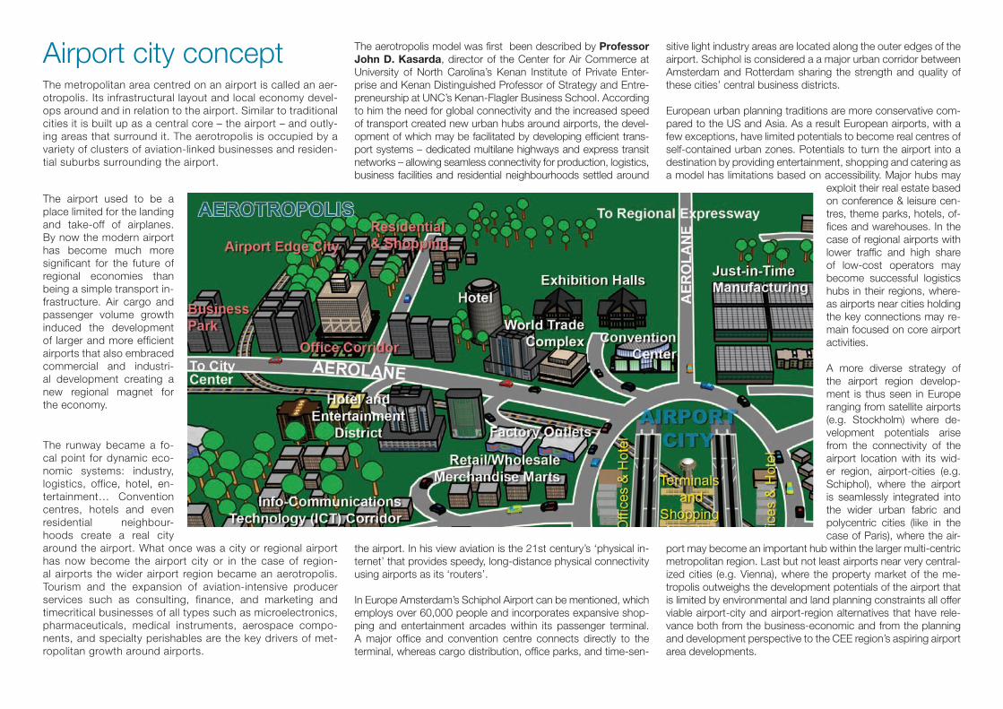
Spatial structural visionThe catchment area of the airport is the eastern gateway to and from the greater metropolitan area of the Hungarian capital. The ‘Airport Corridor’ forming the central axis of this region is an 18 km long urban-suburban ’strip’ between the CBD of Budapest and the M0 motorway with a maximum width of 2 km con-necting a series of intermodal hubs and neighbourhood centres. The regional plan highlighted major infrastructure development needs (part of them already in progress) and identified two clusters of integrated spatial de-velopment along the corridor. One of these clusters includes three action areas around Terminal 2, one within the airport, another at the border between Vecsés and District 18 and one is in the neighbouring municipality of Ecser. The other highlighted cluster of potential developments is to be found between Pestsze-ntlőrinc centre and Terminal I. The cluster includes suburban residential neigh-bourhoods, brownfield industrial areas, airport functions, several sport facilities, a cemetery, municipal administrative and health care centres, several educational facilities, railway and tramway stations. Transition and consolidation of this area may start by the envisaged transport network development. Important structural element of the catchment area is the integrated zone of ‘urban metabolism’ and recreation. This zone consists mainly of croplands, small garden lots, pieces of forests and wetlands. This zone is destined for recreation, urban climate control and nature conservation, while the enhancing demand for pieces of land for new urban operation functions like decentralized energy supply, rainwater retention and eventually also agribusiness or clusters or zero carbon’ housing can be ful-filled here on an optimally organised, integrated manner.
Conditions of implementationThe integrated regional development plan has formulated a complex set of recommendations in order to fulfill the requirements necessary to implement the plan. The measures are highly intertwined and partially build upon each other.Branding aims at marketing and strengthening territorial cohesion (iden-tity) at the same time. Branding is value-oriented and synthetizes the poten-tials: advantageous location of the airport, healthcare cluster along the airport corridor, attractiveness of Budapest as a tourist destination, logistics cluster next to the M0 motorway. It is future-oriented, as it refers to the future pos-sibilities like its situation in the Carpathian Basin, environmental awareness, training cluster related to aviation and logistics. Territorial cohesion is a top priority. Enhancement of institutional capacity (establishment of regional decision-making body) and instrumental capacity (amendment of legal and financial background) have been identified as prereq-uisites in order to exploit completely the territorial potentials. The development plan has identified

Gorenjska Region Regional Development PlanLjubljana Jože Pučnik Airport (Ljubljana airport) is sit-uated in the Gorensjka region, approximately 25 km northwest of Ljubljana and the intersection of two Pan-European corridors: V and X. Direct connectivity within minutes to the arterial roads of Slovenia, namely its highway system, is a major advantage and stimu-lus for further development of the airport. Even though road infrastructure in the vicinity of the airport is well developed and even improving, passenger transport in the vicinity, mostly to the airport from larger surround-ing cities, is still highly dependent on personal vehicle use due to a lack of public transport options.
Ljubljana airport has no rail connections whatsoever, and the nearest railway station is in Kranj, almost 10 kilometres of road distance from the airport. This can be seen as one of the major problems in the devel-opment of the airport city in the future, since it hin-ders passenger as well as cargo transport. A new high speed electrified rail between Ljubljana and the state border with a connection to Ljubljana airport under the coordination of the Ministry of Infrastructure and Spa-tial Planning is planned and the end of construction is planned for 2023.
Ljubljana airport has direct connections with 25 Europe-an airports, meaning approximately 200 flights weekly. Eight airlines are currently using the airport for regular
and chartered flights; the airport also handles freight traffic from several airlines and is used as a primary hub for South few eastern Europe by two of them. An impor-tant point to make is also that Ljubljana airport lies in an area of high competition between local airports.
Passenger transport is currently one of the main activi-ties of the airport. In the last few years, the trend of pas-senger throughput has been falling, most notably from the onset of the economic crisis with the year 2009. Similarly, cargo throughput stalled in 2009, but evidence of an increasing trend can be seen in the past years. It is predicted that in the coming 17 year, passenger traffic will increase by almost 80 % (2030 projection in com-parison to 2013 plan) and cargo traffic by nearly 40 %.The time frame of 20 minutes travel from Ljubljana air-port includes the nearby cities such as Kranj, Kamnik and Domžale. The 60 minutes service area includes
important large cities, notably Slovenia’s capital city of Ljubljana, as well as two large Austrian cities, Villach and Klagenfurt. Moreover, the 120 minutes service area in-cludes the majority of Slovenia and all of its larger cities, as well as a significant part of Austria and a smaller part of Italy, including Udine and Trieste.
In Slovenia as a whole, employment has been fall-ing since 2009 due to the global economic crisis and closing of bankrupts of companies in different sectors, most notably construction and service sectors. In the last decade, the Gorenjska region, which is the prima-ry interest area of the airport, has seen an increase in the number of work positions in the tertiary sector, with a 56,5 % share of employment in the service sector in 2012. Despite this, some municipalities still struggle to overcome their highly industrialized past and transition into the service sector. The highest increase of employ-ment can be seen in professional, scientific and techni-cal sectors, health care, social care and education. This again shows high potential in the region for research and development. A total of 73 entities operate on the Ljubljana airport, a majority of them in the field of supplementary, non-aero-nautical activities. Overall, we can assess that currently, passengers are well taken care of at the Ljubljana air-port, and therefore it would be sensible to give current business entities an opportunity to develop and expand their activities both in-fence and out-fence in the grow-ing airport city, surrounding today’s airport.
The Gorenjska region is under-developed in comparison to the EU-27 average. In 2010 it reached 69,4 % of GDP of EU-27, measured by purchasing power standard per capita and has a 1,5 times lower GDP than neigh-bouring regions in Italy and Austria. On fields other than GDP such as education, unemployment or aging index, Gorenjska is equal or even surpassing other compara-tive and competitive regions.
Tourism is a significant industry from the point of view of an airport’s prospects. Gorenjska region with its nature, cultural heritage, events and activities, is an important tourist destination, with over 650.000 tour-ists per year. S
LO
VEN
IA

All in all, the Gorenjska region is a typical alpine region with picturesque and diverse landscapes, which also has the advantage of great geostrategic position and good accessibility. It is a traditional tourist region in Slovenia, which which generates an important part of Slovenia’s in-come from tourism. Its crucial advantages and the start-ing points for further development are its typical alpine landscape with extremely rich and well preserved natural
sights as well as its cultural heritage in old town centres and in the rural areas. These are tourist destinations that are already well developed and have an established tourist base.
Competence centres are development and research centres that are managed by partners from the industri-
al sector and link partners from the industry and public research sector, centres of excellence are organizations, established within the framework of the scientific and technology policy of the Republic of Slovenia aimed at promoting the concentration of knowledge at priority technological areas and horizontal linking along the en-tire chain of knowledge development. All centres include University of Ljubljana as a partner and most operate from the airport catchment area.
Since Ljubljana’s airport has historically been an impor-tant transport hub in Slovenia, its development plans are always a main point of discussion. Consequently, a de-velopment master plan for the airport is already in place, which is a starting point for this document. Airport in-frastructure development is based on the fundamental development document entitled Master Plan, the Ener-gy Strategy and the existing spatial plans. This includes plans for transport connectivity, a new passenger and a new cargo terminal. The capacity of the new terminal will be 1 800 passengers per hour. The new cargo terminal will have 9 945 m2 of warehouse area and 3 500 m2 of office area and supporting facilities.
The two figures show the elements of the perfect airport city that this document proposes for Ljubljana’s airport city. Due to the specifics of the airport catchment area, the first figure presents the elements which are proposed inside the actual airport city limits, and the second figure presents the elements of a perfect airport city which will be available to the airport city customers, meaning it in-cludes the services found in the vicinity (catchment area) of the airport.
PO
LAN
DRegional Development Plan of Warsaw Modlin Airport Catchment AreaThis document is the first step for the implementation of the concept of Modlin Airport City and indicates the policy Ma-zovia Voivodeship and municipalities of Pomiechówek, Zak-roczym and Nowy Dwór Mazowiecki and also institutions, which participated in the airLED project as RDCB members. Target vision of Airport City has been defined by indicating the directions in which should be lead locally and region-ally development spatial policy.
Warsaw Modlin Airport based on J. Kasarda assumptions should provide following functions: cargo segment, con-ference centre and exhibition halls, hotels, medical and wellness cluster. Proximity to Polish capital city - Warsaw, metropolitan area and unique former Modlin Fortress (Twi-erdza Modlin), are surely significant features that are going to be helpful when choosing specific functions.
The vision of spatial development area around War-saw Modlin Airport will be implemented through policies addressed to specific areas:
1. Farm Production Space Development Policy, together with Policy of Shaping and Preserving the
Resources and Environmental Qualities and Improving the Environment Standards2. Policy of Shaping and Protecting the Cultural Landscape3. Policy of Developing Business Activity and Intensifying the Development around Warsaw Modlin Airport4. Technical Infrastructure Systems Development Policy5. Policy of Improving the Accessibility and Transport Effectiveness of the Area.
The plan sets out the priorities and main develop-ment objectives for the area around Warsaw Modlin airport. The aims are to:
• Increase in competitiveness area including conduct-ing the necessary investment in technical infrastructure around areas of Warsaw Modlin Airport, establish of for-mal and legal conditions to create new jobs and creation of coherent and comprehensive investment offer, taking account of Modlin Fortress (Twierdza Modlin);• Improvement of territorial coherence areas including construction of Warsaw Modlin Airport infrastructure’s el-ements (cargo) and road system elements and a railway connector and railway connection;• Improvement of Warsaw accessibility including cre-ation of a system allowing fast passenger and goods transport, construction of a logistic centre, creation of the around-airport area’s brand, taking account of former of Modlin Fortress potential;• Shaping the spatial structure, providing improvement and maintenance of a high quality natural environmental and landscape qualities through creation of a green ring around Warsaw Modlin Airport City and historic sites us-age as tourist destinations.
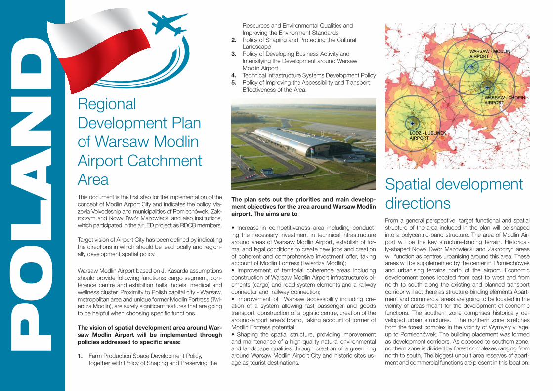
Spatial development directionsFrom a general perspective, target functional and spatial structure of the area included in the plan will be shaped into a polycentric-band structure. The area of Modlin Air-port will be the key structure-binding terrain. Historical-ly-shaped Nowy Dwór Mazowiecki and Zakroczyn areas will function as centres urbanising around this area. These areas will be supplemented by the center in Pomiechówek and urbanising terrains north of the airport. Economic development zones located from east to west and from north to south along the existing and planned transport corridor will act there as structure-binding elements.Apart-ment and commercial areas are going to be located in the vicinity of areas meant for the development of economic functions. The southern zone comprises historically de-veloped urban structures. The northern zone stretches from the forest complex in the vicinity of Wymysły village, up to Pomiechówek. The building placement was formed as development corridors. As opposed to southern zone, northern zone is divided by forest complexes ranging from north to south. The biggest unbuilt area reserves of apart-ment and commercial functions are present in this location.

The band of nature and culture areas will act as an element concentrating growth around the airport. This element is based on existing protected natural environment areas and Twierdza Modlin’s fort system, surround-ing the development areas. Without this band, there would only exist a zone of open farming areas (including forests) which are free of intensive urbanisation processes.
Priorities1. The Rationality Rule - accommodating social, economic, environmental and spatial benefits over longer periods;2. The Spatial Structures Multifunctionality Rule - outlining multifunctional progress activating areas (i.e. transport corridor areas) in every place where there are no environmental and sociocultural contraindications;3. The Integrity and Continuity (spatial and functional) Rule - pointing out areas of environmental value, legally protected and predestined to be legally protected in future, ecological corridors;4. The Regeneration Preference Rule - realized through intensification of the existing development, counteracting the process of occupying new areas for buildings;5. The Nature Compensation Rule - space management which allows maintaining the balance in natural envi ronment and compensating the damage caused by spatial development, increase in urbanisation level and investments necessary for socioeconomic reasons which lack alternatives neutral for the nature;6. The Ecological Foresight Rule - counteracting the threats, based on anticipation;7. The Environmental, Cultural and Landscape Protection Complimentarity Rule - creating the environmental and cultural zones;8. The Economical Energy Use and Waste Production Limitation Rule;9. The Economical Water Use and Retention Increase Rule;10. The Zoning and Outlining Problematic and Functional Areas Rule;11. TheSpatial Collision and Social Conflicts Limitation Rule through socialisation 12. and social participation in creating strategic and program documents.

ITALY Airport System
Development of Emilia-Romagna RegionEmilia-Romagna region is located in north-east Italy as a strategic node for national mobility of people and goods, thus playing a crucial role and function in the Italian eco-nomic and infrastructure system. The regional airport sys-tem consists of four main transport nodes: Bologna (main airport), Forlì, Parma and Rimini in addition to other minor infrastructures.
The efforts of Emilia-Romagna Region are aimed at achieving a coordinated regional airport system playing a coordinative role in supporting the growth of regional air traffic. In addition the Region actively promote every possible co-operation between regional and local airports and their surrounding areas, avoiding harmful competition from nodes of the same territories.
Emilia-Romagna Region’s point of view on the Airport city concept is therefore applied to the regional airport system and it is focused on creating and strengthening relation-ships between airport nodes and their territories rather than on planning new infrastructures. This is one of the points underlined in airLED, especially considering that on the one hand Emilia-Romagna is a territory deeply urban-ized with difficulties in building new infrastructures due to the lack of free land, and on the other hand it is possible to develop different airports together.
The regional (and National) transport system has Bologna as its main node. It represents a strategic portal for the accessibility of the Emilia-Romagna regional economic system, thanks to its central geographic location within the region. The important transport infrastructures ensure good and wide road and rail connectivity, suitable for the businesses gravitating within this area. The growth trend in passenger traffic at Bologna Airport is reaching 6 million passengers/year, an excellent trend if compared to the national trend which is suffering a general decrease (with reference to the ACI classification).
The other airport infrastructures in the region are to be considered local, and therefore more sensible to the changes of the economy and market. Although they are small they benefit from important assets, including the ac-cessibility, thanks to the location of the corridor of the Via Emilia, part of EU corridor 1 and to be considered as one of the area better linked in northern Italy.
Suggestions and results of the airled project will be con-sidered in the new coming Regional Integrated Transport Plan (PRIT). Generally, new mutual attitude between air-ports and territory will be encouraged: in particular it has been proved that Emilia Romagna area is a stable market from the air traffic point of view as tourism and in general the low-cost generation traffic, completes and integrates the relevant share of business related traffic. This traffic has made possible an increasing trend possible notwith-standing the economic crisis at global level.
Airports traffic is deemed to be of high importance for both the regional system and the airport management, therefore a further step of the analysis already available is planned beyond airLED in response to the idea and concept emerged during the project: passenger flows will be an-alysed more in depth with a focus on origin/destination of the displacement, modal choice, reasons for the displace-ment, frequency and stay-over duration in order to assess the capability of the regional offer system to meet with the visitors’ needs. Also, the regional traffic model will be im-proved by adding the Trans-Tool application, an analysis software model made available by the European Union.
A shared and synergic cooperation network will also be encouraged involving Fair and the regional promotional of-fices system, to enhance the regional potential even more. A core role is played in this field by the Regional Agency for tourism, profiting also in the next future from the oppor-tunities promised by the Universal Exposition to be held in Milan in 2015 and the current creation of an agrifood pole and stable fair for food (FICO) in Bologna in the next years.

The relationship between air traffic growth and the negative externalities especially related to the resident population is deemed to be a crucial aspect. Considering the very limited distance of the airports from the city center of the Emilia-Ro-magna cities, important efforts have to be made to find solutions and to ensure a reduction of negative impacts and to create a positive and constructive discussion among policy makers, the population and transport infrastructure managers.
Regarding the freight traffic, Bologna hosts an intermodal hub (Bologna Interporto) which includes freight integrators and air cargo entities. Being in a central position at the national level at
the junction of two of the most important motorways and railway corridors (also at EU level) linking the north to the south, the in-termodal platform is well developed.
During the airLED RCDB meetings held in Bologna, also inter-modal operators were involved, allowing the Emilia Romagna Region to acquire knowledge on the air cargo phenomenon: ex-cluding the parcel sector, in the hands of specific players with a time sensitive supply chain (UPS, DHL, TNT and others which depart from the Bologna airport daily with dedicated air cargo) most of the air freight traffic departing from Italian airports is actu-
ally performed by road towards the main European airport hubs, as volumes are not sufficient to justify a scheduled cargo flight; this freight undergoes all the security and customs controls typ-ical of air freight traffic but the trip is done by road on dedicated and secured trucks. Many and various are the reasons behind the presence of this “avio-truck” phenomena as the lack of ware-house inside the airports as well as the longer times foreseen to have infrastructure enhancements, higher fees to be paid if inside the airport, the change during the years of plane models for the regional flights (not sufficient to receive also cargo in the hold luggage) or the timing from land to take off asked by low cost companies (not sufficient to load/unload cargo).
Important steps need to be made in the near future to better assess the functioning of the supply chain at the regional level. To achieve this goal, Customs Authorities and other regional and national stakeholders will be involved in the enhanced Regional Roundtable on Freight Traffic in order to discuss and brainstorm new ideas and opportunities for development.
The last topic on which Emilia Romagna Region envisaged op-portunities for further development has been the technological and ITS systems: airports are valuable infrastructures but also capable to process and host high value added items as well.
Airports are becoming technologically linked to their territories, not only due to the goods and passengers they serve but also through the dissemination of real-time information. Mobile apps available for smartphones have been developed to make the passenger experience easier starting from the boarding pro-cedures or entertaining inside the terminal; likewise, airports’ presence on the social media (Twitter, Facebook, Instagram) is a spreading phenomenon, worth being honored with a tailored Report by ACI Europe (Digital Report, ACI Europe - 2012). The presence of each airport of the Regional system on digital me-dia will be encouraged as this is an opportunity to get in touch with a large amount of people, going beyond the traditional
barriers of the catchment area. Opportunities will be examined to put digital opportunities with traditional information regarding the territory into cooperation: conceptual maps, touristic and fair-related information, Imagineering, timetables of intermodal opportunities are the best candidates to be implemented in the next future.
Finally, a new webpage with links to the regional airport system, tourist information, events and fairs, entrepreneurship opportu-nities as well as the contents and the outcomes of the Airled project will be developed.

Statisticaldecision supportingmodelAs part of airLED project a multi-step predictive statistical deci-sion support model was developed. Direct and indirect impact zones are in the scope of the model according to the previous Status Quo analysis of the Budapest airport catchment area. All together 69 districts and towns are the observation units (statis-tical population) of the cross-sectional database (2011 census). The observation units are described by socio-economic varia-bles like indicators related to demography, geography, unem-ployment, transportation, infrastructure and revenue generating capacity of municipalities and business actors.
In the scope of prediction there are three key target variable, namely current revenues of municipality, local tax revenues and number of employees; all of these are related to municipality of Budapest district 18. In order to predict these figures the first step is to build up three different regression models based on the cross-sectional database. Using regression models it is possible to explore the relationships among the target variables and the other indicators. The following step is to calculate (predict) the future values of the relevant explanatory variables of these re-gression models by using time-series analysis in order to forecast
the future value of the target variables. In the time-series analy-sis special airport indicators are involved, like number of arriving and departing passengers and cargo. In this way it is possible the inclusion of business activity of the airport in the final predic-tion. The next step was to rebuild the regression models on the cross-sectional database using the predicted (derived from the time-series analysis) values of the explanatory variables. The final step of modeling process is to use the latest regression models to predict the future value of the three key target variables. In parallel with the preparation of the multi-step statistical decision support model, a model software has been developed too. Using this software tool it is easy to apply the model in different data environment.
3D Imagineering ToolTwo project partners were responsible to develop an Imagineer-ing Tool that would help the Airport managers, national, region-al and local authorities and stakeholders that are dealing with regional development to estimate and evaluate the influence of the airport growth to the regional economy and infrastructure in the future.
The Imagineering Tool main objectives are:
− to provide partners, national, regional and local authorities in charge of urban and territorial planning an instrument capable of taking into account various parameters and information to iden-tify the main drivers in area development and both the existing and potential relationships between the airport and the territory;
− to give (through a series of fixed and variable parameters) infor-mation on the specific status of the territory involved, its charac-teristics, vocation and development trends in both present and forecasted scenario under the shed of the new strategy and de-velopment criteria assessed by the project;
− to interpret information gathered by a series of outputs of this project such as National Status Quo Analyses, Regional Road-maps for Endorsement, Regional Polycentric Development Plans and Transnational Strategy;− to issue partners and authorities information through the use of the concept of “Imagineering”, that is to say visual images which represent the information provided and drawn by the applicationof this methodology of investigation to the territory;
− to generate information about the influence of the airports to the regional development, regional GDP, employment, economy, tourism and infrastructure development;− to allow - with simplified software orders – spatial analysis of the Airports infrastructure and surrounding area;− to allow visual Imagineering of the potential growth of the par-ticular Airports on the present location;− to generate the future spatial and infrastructure needs, if the trends about the growth of the airport traffic will come true;
− to generate the warnings, limitations and milestones related to the Airport infrastructure and the growth of Airport traffic;− to generate – in a simple way - sufficient information to the national, regional and local stakeholders which are involved in decision making process- to react in-time and support theAirports growth and the nec-essary investments in the local/ regional economy and infra-structure.

One Stop ShopOne-stop-shop in Central Europe settings aims to provide a practical platform to boost business and investment development. It also provides practical advice on business development or relocation of any company, industry actor or investor interested in setting up an operation or expansion in airport catchment areas. Definition of One-stop-shop with-in the framework of airLED project:
It is a point or institution itself where anybody could get as much information as possiblethat could help or foster decision making process. It is a point where business persons can recourse to obtain advice and support to help them establishing and expanding their business.
These centres may also issue licenses and permits needed by businesses to start-up, operate or ex-pand. These centres improve the local business environment by reducing the number of separate agencies and offices and business may need to be visited for advice or to apply for various licenses and permits. They save public and private time and im-prove efficiency as a result. One of the most impor-tant aims of one-stop-shop is to provide a practical platform to boost business and investment devel-opment. Also to provide practical advice on busi-ness development to any company, industry actor or investor interested in setting up an operation or expansion in airport catchment areas. In One-stop-shop the needs of different target groups should be considered: local, regional and national planners, tourists, investors, logistic companies etc.
One stop shop in Slovenia, Gorenjska: In the frame of the airLED project One-stop-shop was estab-lished in Gorenjska region. Municipality Cerklje na Gorenjskem (where also national Ljubljana airport is located) provided the human resources and in-frastructure for its operation with the purpose to enhance business and investment development in the area. Since September 2014 One-stop-shop has been operating and providing appropriate and effective information support especially for the po-tential investors, industry and business actors.
Transnational strategyTransnational strategy provides a strategic framework and guidance for improved polycentric governance as regards the airLED thematic pillars. In the recent years, new market trends such as network and airline consolidation, aggres-sive market strategies by low cost airlines and subsequent-ly by middle-eastern airlines and airports, crescent level of competition and cost cutting policies have shocked the sys-tem and forced the players to restructure their framework.
The possibility to develop into an airport city depends from traffic flows, connectivity, centrality in a target market, re-liability and presence of eager economic players but also on factors such as the nature of economic-fiscal-regulatory regimes and externalities.
A deep investigation and understanding of the market trends has deemed necessary, since the traditional views have been outdone by the high-paced changing of the sys-tem. A few topics have been pinpointed as crucial in the development process: capacity, connectivity, investment opportunities, marketing and territorial assets.Capacity, resilience to delays, connectivity/attractivity, possibility to open new routes are linked to it. To improve the capacity huge investments and complex processes are needed, not easy during the crisis
Connectivity, essential for the competitiveness of a terri-tory, it is expected to become a core elements in airports’ business plans. It depends from the Country size and popu-lation, GDP and geographical location. Policy makers need a progress in awareness on this issue and topics such as capacity, air traffic deregulation, market opportunities, cost efficiency and common legislation on airport-airline cooper-ation have to be encouraged.
Airports’ technological link to the local territory is becom-ing a valuable topic. Airports (and airlines) started to equip themselves with advanced technologies to better meet passengers expectations. Smartphone Apps and presence on social media are making the boarding procedures eas-ier and the passenger experience inside the terminal more entertaining. The Transnational strategy includes all these variables in order to guide partners in the development of integrated regional polycentric development plan.

The airLED partnershipThe Local Government of Budapest District 18, Pestszentlőrinc-Pestszentimre, HU
Municipality of Vecsés Town, HU
KTI - Institute for Transport Sciences Non Profit Ltd., HU
Mazovia Voivodeship, PL
Institute of Urban Development, PL
Municipality Cerklje in Gorenjska Region, SL
Business Support Centre Ltd. Kranj, SL
Emilia-Romagna Region, IT
Institute for Transport and Logistics Foundation, IT
This project is implemented through the CENTRAL EUROPE Programme co-financed by the ERDF For further information please visit www.airled.eu


![Aerotropolis Leadership Board[1]](https://static.fdocuments.us/doc/165x107/54685f37b4af9f3f3f8b5c67/aerotropolis-leadership-board1.jpg)