From Africa to Australia
39
From Africa to Australia: Elements for an early coastal route C. Coup´e & J.M. Hombert August 2001 Mailing address: Dynamique du Langage ISH 14, avenue Berthelot 69363 Lyon Cedex 07 [email protected] jean-marie.hombert@univ -lyon2.fr * We thank Edouard Bard, the LSCE of Sacla y and the Serv ice Oc´ eanog raphique et Hydographique de la Marine Fran¸caise for their data and information about the evolution of sea levels and visibility at sea. We also thank Nicholas Evans, R´ emi Dallongeville, William Foley, Laurent Sagart and Paul Sanlaville for their useful useful comments on this article. Special thanks to Harriet Jisa for help with the English version. 1
Transcript of From Africa to Australia
8/12/2019 From Africa to Australia
http://slidepdf.com/reader/full/from-africa-to-australia 1/39
From Africa to Australia:
Elements for an early coastal route
C. Coupe & J.M. Hombert
August 2001
Mailing address:Dynamique du LangageISH
14, avenue Berthelot69363 Lyon Cedex 07
[email protected] [email protected]
* We thank Edouard Bard, the LSCE of Saclay and the Service Oceanographique etHydographique de la Marine Francaise for their data and information about the evolution of sea levels and visibility at sea. We also thank Nicholas Evans, Remi Dallongeville, WilliamFoley, Laurent Sagart and Paul Sanlaville for their useful useful comments on this article.Special thanks to Harriet Jisa for help with the English version.
1

8/12/2019 From Africa to Australia
http://slidepdf.com/reader/full/from-africa-to-australia 2/39
Abstract:
Following the lines traced by much research concerning the colonization of Australia, thisarticle attempts to bring a new contribution by re-examining and developing the idea of a veryold first migration towards Papua New Guinea (PNG) rather than towards Australia proper.
Starting from current theories about migrations from East Africa, the authors propose anearly arrival in South East Asia, using as a source of evidence datings from Australian sites.Adding to paleo-geographical studies of current Indonesia, they defend the proposition of an intentional and visually guided passage towards PNG and not towards the North-Westshores of Australia via Timor. Different hypotheses concerning migration are considered withemphasis on coastal migration from east Africa to south eastern Asia and finally towardsSahul.
2

8/12/2019 From Africa to Australia
http://slidepdf.com/reader/full/from-africa-to-australia 3/39
1 Introduction
Over the course of the history of human migrations, our ancestors have proven time and timeagain their capacity to conquer and settle all regions of our planet. In the context of thishuman expansion, Sahul, the name given to the large continent regrouping Australia, Papua
New Guinea (PNG) and Tasmania, constitutes a unique place of study. Despite very impor-tant variations in sea level during the course of glacial episodes, this area has always beenseparated from the south eastern point of the Asiatic continent by sea barriers of a minimumof 100 kilometers wide. During a long period of the last glacial episode, this extreme partof Asia was in fact more extensive than it is today, grouping Malaysia, Borneo, Sumatraand Java into a vast region called Sunda. Modern man was very probably the first largespecies coming from Asia to overtake this geographical isolation. Refining the date of thisfirst crossing allows both the proof of the existence of Homo Sapiens in south East Asia andthe estimation of technological and cultural capacities of our ancestors through investigationof the means of navigation used.
In parallel to different archeological and paleontological evidence on the Australian ter-ritory, the Out of Africa theory allows for the positioning of the colonization of Australiain a more general framework, by associating it with an initial expansion from the Africancontinent. Within this framework, we will expand on research concerning sea levels and to-pography of Sunda and of the Wallacea region (the waters and the islands separating Sundafrom Sahul), with the aim of bringing older dates to light. We will develop the idea of a firstpassage “a vue” towards PNG and will discuss different possible migration routes, consid-ering both arguments already proposed in the literature and different connections betweenaboriginal Australians and Papuans.
2 Archaeologic and palaeological evidence of the colo-nization of Sahul by Homo Sapiens
2.1 Archaeological evidence
During the last forty years, given the datings of different Australian and PNG sites, estima-tions for the arrival of man to Sahul have been pushed back considerably, ranging from lessthan 10,000 years in the sixties to more than 60,000 years nowadays. These new estimationswere made possible in part due to different methods of dating and their evolutions: oldercarbon 14 datings, mass or γ spectrometry, electronic spin resonance (ESR) in addition to
thermoluminescence (TL), optically stimulated luminescence (OSL) since the nineties. De-bates have accompanied these technological advances (see, for example [RJS94a] and [All94]for discussion of the temporal limits of carbon 14 and thermoluminescence), but the pushingback of the dates is clearly established today and will perhaps continue in the years to comewith a more accurate dating of already known sites and the discovery of new sites.
It is impossible to give an exhaustive account of Australian sites. However, for our pur-
3
8/12/2019 From Africa to Australia
http://slidepdf.com/reader/full/from-africa-to-australia 4/39
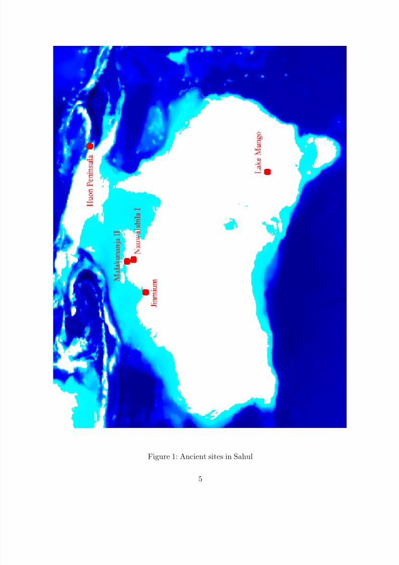
poses here, it is important to briefly review some of the oldest archeological evidence availablefor diverse regions of the old “Greater Australia”. This short review should not however ig-nore the great number of more recent sites (from 30,000 BP, see for example [Bow92]for anaccount of numerous Australian sites).
Malakunanja II, situated in the Northern Territory of Northwest Australia was dated in
1990 close to 50,000 BP by thermoluminescence [RJS90]. As for the majority of sites forwhich there are very old datings, only lithic artifacts were discovered during excavation.
Seventy kilometers to the south of Malakunanja II, Nauwalabila I, in the Deaf AdderGorge region, was dated by OSL. Optical dates were given for non burned quartz sedimentsin an excavation undertaken in a rocky shelter. Dating the stratigraphic levels immediatelyanterior and posterior to deposits of lithic artifacts and pigments, archeologists have defineda time span of [53.4+/-5.4 ka, 60.3+/-6.7 ka] for human presence [RJS+94b].
In PNG, the site of the Huon peninsula also yielded some stone tools. Consisting of coral terraces of hundreds of meters high created by a tectonic eruption, it presented animportant interest for the study of variations in sea levels (which we will return to in 4.2)[Cha74]. The datings of this site have evolved from 40,000 - 60,000 BP fifteen years ago[GCMP86] to 52,000 - 61,000 BP (by measures of the coral terrace supporting the lithicartefacts [COM+94]).
Still older datings were proposed in 1996 for the Jinmium rock shelter in the North-ern Territory. By thermoluminescence Fullagar & al. obtained datings of lithic artifacts of 116,000 +/- 12,000 BP [FPH96]. These data, however, have been seriously contested byother researchers who suggested the possibility of contamination of a part of the sedimen-tary grains used for measurement or of vertical displacements of artifacts in the stratigraphy[RBO+98] [OA98].
Finally, one of the major discoveries of the last years took place on a site known for manydecades, the Willendra Lakes region, in the west of New South Wales. Lake Mungo is one of
the dried lakes which has produced several human skeletons. Successive datings undertakenin this area has produced first the date of 28,000 - 30,000 BP (carbon 14 dating), then be-tween 36,000 and 50,000 BP (thermoluminescence dating) and finally 62,000 +/- 6,000 BP(datings measured directly on the bones of the LM III skeleton, using various techniques suchas ESR, mass or γ spectrometry on uranium isotopes, . . . ) [TGM+99]. Thorne underscoresin this respect the importance of directly dating bones.
These last dates are the oldest currently known for human presence in Australia (if theextremely controversial Jinmium site is ignored), but the localization of the Mungo site insoutheast Australia, as opposed to the most probable arrival sites, leaves open the possibilityof an arrival which is older by a minimum of a few thousand years.
Figure 1 presents the sites that we have discussed, giving their geographical position.
2.2 Animal extinctions and ecological changes
Parallel to archeological data yielding direct observation of the presence of humans (bones,artifacts), other sources of information have been proposed to argue for the occupation of Australia.
4
8/12/2019 From Africa to Australia
http://slidepdf.com/reader/full/from-africa-to-australia 5/39
Figure 1: Ancient sites in Sahul
5

8/12/2019 From Africa to Australia
http://slidepdf.com/reader/full/from-africa-to-australia 6/39
The extinction of part of the indigenous Australian fauna at the end of the Pleistoceneera (more than 85% of land species of more that 44 kilograms, for the most part marsupials[MMJ+99]) has been claimed to have resulted from human activity [Thr80]. The impact of human activity is probably attributable to hunting, but also to modifications of the environ-ment, related particularly to different uses of fire: hunting, signalling, creation of new prairie
zones more suitable to hunting [Jon92]. Naturally occurring fires must have occurred on theAustralian territories, but man’s arrival probably strongly increased their frequency. In thisrespect the study of a sequence of fossil pollens by Singh [SKC81] revealed important changesduring the course of the last glacial era: the appearance and the persistence of importantfragments of coal, and the evolution of vegetation towards species more resistant to fire. Thelayer (zone f, see Wright’s article) revealing the beginnings of the transformations inducedby human use of fire was dated by Singh at approximately 120,000 years, and subsequentlyreevaluated by Wright to approximately 60,000 years [Wri86]. Other studies focussing aroundthese same dates show important ecological modifications caused by human fires. Johnson& al. analyze, for example, the decline of the summer monsoon in the Lake Eyre region asresulting from diminishing transfers of humidity between the biosphere and the atmospherewhich caused the monsoons to move to more interior land [JMF+99].
Some authors propose that no massive animal extinction took place before 30,000 BP[Mur84]. Nevertheless some recent studies point to a different conclusion: a study by Miller &al. [MMJ+99] on the disappearance of the large land bird Genyornis newtoni proposes a dateof 50,000+/-5000 BP, based on datings of eggs of this species in different Australian sites inthe east and the southeast of the central region. Comparisons with eggs of other species aswell as a climate study argue that this disappearance is attributable to the presence of man.It is argued that hunting and fire have modified the vegetation.
This rapid review of the current archeological and paleontological data for Sahul permits
a partial understanding of the Australian situation. In light of these discoveries, it wouldappear that man’s arrival can be estimated at 65,000 or 70,000 years at least. The next stepin our paper consists of framing this situation and its evolution in more global models of population expansion. Our goal is to better interpret and relate data from Africa to thatavailable for Asia or Australia.
3 The Out of Africa Hypothesis and the first migra-
tions towards Southeast Asia
3.1 Principal theories of the development of Homo sapiens: re-placement of regional continuity
Two major and largely opposed theoretical models are available to explain the appearanceand the development of modern man or Homo sapiens.
The model of regional continuity postulates an evolution by local evolutionary jumps of the Homo erectus population towards Sapiens. Developed essentially by Wolpoff, Templeton
6
8/12/2019 From Africa to Australia
http://slidepdf.com/reader/full/from-africa-to-australia 7/39
and Thorne [TW92], this theory is based principally on archeological evidence, i.e., skullbones sharing characteristics of both Homo erectus and Homo Sapiens in China, in Europeor in Australia. Local evolution should normally lead to different species, but the geneticflow between the different human populations would have allowed a single species to bemaintained.
The second theoretical model proposes that the evolution of Homo erectus to Homosapiens took place in a unique location, followed by expansion of these Homo sapiens and areplacement of more primitive populations by more modern ones. For over fifteen years theOut of Africa theory proposed that East Africa is the origin of this emergence about 150,000years ago. This theory is based upon the apparent genetic separation between Sapiens andNeanderthal in Europe (in particular, no sign of interbreeding) and upon a genetic data basewhich establishes relations between modern human populations. Nuclear and mitochondrialDNA studies seem to indicate that Africa is the sole genetic source of existing populations,with a more or less wide diversity of the African group in relations to other large European,North and South Asian groups. This position argues for an older emergence in Africa whichwould have led to a greater genetic diversity. Cann & al. propose the time span of [140,000;290,000 BP] for the appearance of Homo sapiens and the span of [62,000; 225,000 BP] forthe separation of the two primary branches of the tree of minimum length (one branch leadsonly to African mtDNAs, while the second one leads to African and non-African mtDNAs)[CSW87].
3.2 Coastal migrations towards Southeast Asia
In the framework of the Out of Africa theory, it is necessary to explain how the humanexpansion outside of Africa began and evolved towards other continents. What dates can begiven to this expansion and which routes were taken ?
A recent theory, developed by Stringer [Str00] proposes a migration along the coasts of Asia which would have preceded migration toward Europe. Some arguments are availableto justify this migration. The main one is the proof of a very old (around 125,000 BP) useof sea resources, found on the shores of the Red Sea in Eritrea [WBB+00]. This discoveryattests a very old adaptation to coastal regions. Walter et al. propose that this adaptationwas a response to changes in the paleoclimate during the last glacial cycles. The increasein human population and competition along coastlines during arid periods is suggested tohave pushed some human groups to migrate. Such a period is attested in southwest Africabetween 110,000 and 90,000 BP, and although very little is known about the climate inother parts of Africa, there is a strong probability that this pattern was largely distributedover the continent [Ada97]. Stringer proposes, in addition, that the coastal migrations would
have permitted the conservation of a relatively uniform environment during migration. If themigrants had progressed in the interior they would have been forced to adapt to differentand changing environments.
3.2.1 Possible routes from East Africa
Many principal coastal routes could have been taken from East Africa to Asia: a first onewould have followed the western coastline of the Red Sea to the Middle East, then either
7

8/12/2019 From Africa to Australia
http://slidepdf.com/reader/full/from-africa-to-australia 8/39
travelling directly east to the coasts of current Iran, or following along the coast of theArabian peninsula. A second and faster route would have gone directly to the Arabianpeninsula via Cape Yemen. The distance of sea to cross does not exceed twenty kilometerswith current water levels, and this distance must have been reduced because of a fall inwater level of some tens of meters (-30/-40) as was the case 100,000 years ago. If the first
Australians could have crossed much larger marine expansions twenty or thirty thousandyears later (see 4.1), such a short crossing in this region of the globe is very probable. Asecond movement would have followed across the Persian Gulf, and once again a low waterlevel of the would have facilitated the passage. The small number of sites found along theArab coastline could appear as a counter argument to this proposal. However, this can becountered by arguing that potential sites are now submerged or that very few excavationshave been carried out in this region. An additional argument can be found in the life style of these very nomadic migrants, making little use of caves. It is this last argument that Murrayinvokes to explain that the extinction of certain Australian animal species is not correlatedwith the presence of remains of these species in the discovered caves [Mur84].
The two proposed routes might have been and most probably were taken at differenttimes. The second proposed passage, however, speeds up considerably the passage to Asia(this obviously does not mean that the migrants consciously choose the shortest route) andpushes back the plausible date of arrival in Southeast Asia.
Figure 2 traces the two possible routes leading out of east Africa, as well as the coastalmigration to Indonesia. Sea level on the map is 40 meters lower than the current level.
3.2.2 “Timing”
What dates should be proposed for the first expansions of modern man outside of Africa ?Several theories are available and large variation exists among the proposed dates.
Lahr and Foley argue for a multiple dispersal model, and hypothesize a passage alongthe coast of the Arabian penisula [LF94]. According to them, the initial migration to Asiacould have taken place at any time between 100 and 50 kilo-years (this later extremity isnow known to be later than the dates given for the first Australian occupation). They alsorefer to Kingdon’s proposal of a first migration toward Asia from the Middle East region90,000 years ago [Kin93].
Klein proposes a more recent expansion date around 45,000-50,000 BP, that he links tothe passage to Upper Paleolithic and Later Stone Age in Africa and Europe[Kle99] (p. 588).However, he raises the problem of ancient datings in Australia which would imply an earliermigration to eastern Asia than to Western Asia and Europe (p. 593).
Regarding new evidence in Eritrea, paleo-climatic hypotheses and dates in Australia, andin line with these different theories, we propose a time window of 110,000 - 90,000 years forthe departure from Africa towards Asia. Depending on the route followed by first emigrants,this span may allow the presence of the morphologically modern types found in the MiddleEast (e.g. at Skhul and Qafzeh) 90,000 to 100,000 years ago [Van92]. But these discoveriesmight also very well relate to a second and distinct expansion. We do not see any problem in
8

8/12/2019 From Africa to Australia
http://slidepdf.com/reader/full/from-africa-to-australia 9/39
Figure 2: Migratory routes from Africa to Sunda
9
8/12/2019 From Africa to Australia
http://slidepdf.com/reader/full/from-africa-to-australia 10/39
an ancient migration that did not leave any clues in the Levant, since the paths taken mayhave bypassed this area.
Fixing the date of the beginning of migration is a first point. The second point is toestimate the time necessary for travelling from the point of departure to the point of arrival,
in this case the extreme southeast of the Asiatic continent. This time depends obviously onthe local population expansions and on the more or less arbitrary character of population’smovement.
In some cases it is possible to estimate rather precisely the speed of displacements. Forsubsequent periods, and with the aid of genetic gradients, Cavalli-Sforza was able to measurethe speed of movement for the first farmers [CSMP93], which results in a calculated speed onthe order of 1 kilometer per year. Of course, this estimated speed should not be considered torepresent a long and constant movement, but rather as a mean of more chaotic movementswhich can be compared to Brownian particle movement in hot liquids. Thus, it is likelythat the displacement of individuals resulted from constraints related to food supply. Inthe case of a coastal migration, the extension of fishing zones and areas suitable for theharvesting of sea foods, or hunting territories along the coast probably explains the longprogression to the east. If we adopt the speed proposed by Cavalli-Sforza, which concernpopulations in course of sedentarisation, the time required to cover the southern coasts of the Asiatic continent can be estimated at approximately 10,000 to 15,000 years. It is possiblethat population displacement was much faster, on the order of a mean of many kilometersa year: the exploitation of sea resources has the advantage of being relatively homogeneousalong the coastline, as is the environment, as opposed to displacement over land which issubject to geographical and climatic constraints. This argues for a relatively rapid migration,some thousands of years, between the two regions. The beginning of an expansion from Africaaround 110,000 BP could very well lead to an arrival in Indonesia as early as 95,000. It should
be noted that a migration along a coastline is necessarily more “directional” and consequentlyfaster than a migration in open country. Between two possible directions, either retracingtheir path or moving further along the coast, first immigrants might have preferred the laterpossibility to exploit sites never reached before.
3.2.3 Cultural adaptation to navigation
As we will see in what follows, the first arrivals to Australia must have crossed sea expansesof many tens of kilometers between the Wallacea islands. We can hypothesize that this nav-igational capacity developed during the course of the long trajectory from East Africa toSoutheast Asia (and not only in the Indonesian region). The crossing of mangroves or rivers,
often many kilometers wide (particularly at their mouth), as were probably the delta regionsof the Ganges or the Indus, or moreover the numerous islands of the Red Sea or the PersianGulf, must have offered new occasions for the use of means of navigation. If the route takenby some human groups was in fact via the south east of the Arab peninsula, the crossingof the Yemen Cape and the Persian Gulf must represent the first sea bound obstacles. Anargument which will play a role in the remainder of our argumentation is the possibility of being able to view the opposite coast from the departure point. Our ancestors must thus
10

8/12/2019 From Africa to Australia
http://slidepdf.com/reader/full/from-africa-to-australia 11/39
have progressively developed navigational techniques through the realization that it is easierto reach a destination by boat than to go around the obstacle on foot.
It seems important to us not only to speak of coastal migrations, but rather of theslow development of a real coastal culture : fishing, boating or shell harvesting techniques,
transmitted from one generation to another, swimming, knowledge of tidal movements, useof nets, use of moonlight for night travelling, carrying of drinkable water in appropriatecontainers, loss of non-coastal techniques (avoidance of some specific predators, huntingtechniques, . . . ), increased demographic growth rates, . . . . Such an adaptation would haveprevented immigrants from leaving coast for more interior lands.
Following this proposal, we suggest that even if the Indonesian region was an appropri-ate place to develop sailing skills, it was not the primary center for the emergence of suchknowledge. Humans would have in fact acquired this knowledge earlier along the way fromAfrica to southeast Asia.
Within the framework of current hypotheses concerning the migration of modern manoutside of Africa, the Australian datings give a lower limit for the initial arrival in Indonesia,but they do not fix an upper limit. The data summarized above do not rule out a reasonableestimation of arrival in Indonesia much before 65,000 BP. In what follows, we will developthis idea, examining first the paleogeographical features of the Wallacea area.
4 The recalibration of a paradigm for the first peopling
of Greater Australia
The title of this section is borrowed from work by Birdsell [Bir77] in which different routes
leading from Sunda to Sahul are examined in detail. It is important to reexamine this workin light of current datings, of current knowledge about the evolution of sea levels and of theframework given by the hypothesis summarized earlier about the Out of Africa migrations.
4.1 Synthesis of hypotheses concerning the passing from Sunda to
Sahul
Much work has been devoted to the passage from Sunda to Sahul by crossing the Wallaceaislands. Birdsell (1977) details two main routes (each one with two or three alternative sub-routes) which allow one to reach Sahul from Sunda. He examines these routes at sea levelsof -150 meters and -50 meters in relations to current sea levels. By considering the distancesbetween islands, altitude and width of targeted islands, he prefers the southern routes of passage for sea level at -150 meters, which he dates at 53,000 and 20,000 BP. For sea level at-50 meters it is the northern routes which are preferred because of the much greater distancebetween the Australian coastline and the islands along the southern route.
Figure 3 presents these two routes, with sea level at -50 meters.
11

8/12/2019 From Africa to Australia
http://slidepdf.com/reader/full/from-africa-to-australia 12/39Figure 3: Birdsell’s proposed routes to Greater Australia
12
8/12/2019 From Africa to Australia
http://slidepdf.com/reader/full/from-africa-to-australia 13/39
Following Birdsell’s work, many researchers became interested in this hypothesis andattempted modelling of the human crossing and expansion along the coast. Jones summarizespart of this work, examining in particular a drift from the Timor Islands or neighboringislands towards the North-western shores of Australia [Jon89]. Some of this research focusedon the crossing proper, and some concentrated on the probability of a small group to survive
and spread out on the Australian continent.Let us consider first the work on the crossing proper. During the wet seasons strong winds
blow from the Timor Island to Arnhem Land in Australia. The Barra could have pushed seavessels towards the Australian coast. Jones points to small islands of vegetation measuringmany square meters drifting on the Sepik River in the north of PNG and capable of coveringmany kilometers at sea [Jon92]. However, the distances between the major islands are veryprobably too long for these small islands to cover. In addition, if this were the case, thereshould be traces of other large species moving from Sunda to Australia. No such tracesexist. Most probably men of this period used rafts made of bamboo or other resistant woodcommonly found in Southeast Asia [Bir77]. Jones proposes that inhabitants of the Sundashores were carried off by currents or storms and drifted to the Australian coast [Jon89].
Using simulations, Thorne estimated the crossing time at approximately seven days[TR89]. This relatively long crossing time necessitates sufficient drinking water and food,or the means of obtaining them later from the sea.
The arrival of a very small group on the Australian shores does not guarantee a successfulcolonisation. Such a group must have been able to increase population size, avoiding extinc-tion from restricted numbers of individuals. Calaby proposes that even one young pregnantfemale could have supplied the first steps to colonization [Cal76], though this view has beenstrongly contested by others [WO79]. An expansion depends most probably on a larger num-ber of individuals, crossing to Australia at different times. McArthur attempted to evaluatethe probability of such a scenario (in Polynesia) leading to successful population expansion,
without however taking into consideration genetic bottlenecks resulting from such situations[MST76]. He concluded that knowing factors as mortality, effective fertility or mating pat-terns is essential to estimate the minimum population leading to a successful development,and that any proposal without remains futile .
The majority of the work that we have discussed so far postulates for the most part thatthe sea crossing were due to chance, with numerous attempts and failures. After presentingthe data concerning the evolution of sea levels in the region, we will defend the hypothesisthat the crossings were in fact far more intentionally planned.
4.2 Data concerning changing sea levelsAs we have already mentioned, one of the major aspects of the crossing between Sunda andSahul is the important differences in sea level over the last glacial cycle. In order to betterunderstand the evolution of water levels, paleo-climatologists use different types of data.Measures taken in corals and measures of the oxygen 18 concentration in deep-sea sedimentcores or ice samples at different depths are robust indications in the reconstruction of sealevels. Measurements taken in different places at a given date can however often reveal impor-
13

8/12/2019 From Africa to Australia
http://slidepdf.com/reader/full/from-africa-to-australia 14/39
-140
-120
-100
-80
-60
-40
-20
0
20
0 20 40 60 80 100 120 140
R e l a t i v e s e a l e v e l ( m )
Time (kilo-years) BP
Figure 4: Global changes in sea levels during the last glacial episode, reproduced from[BHF90]
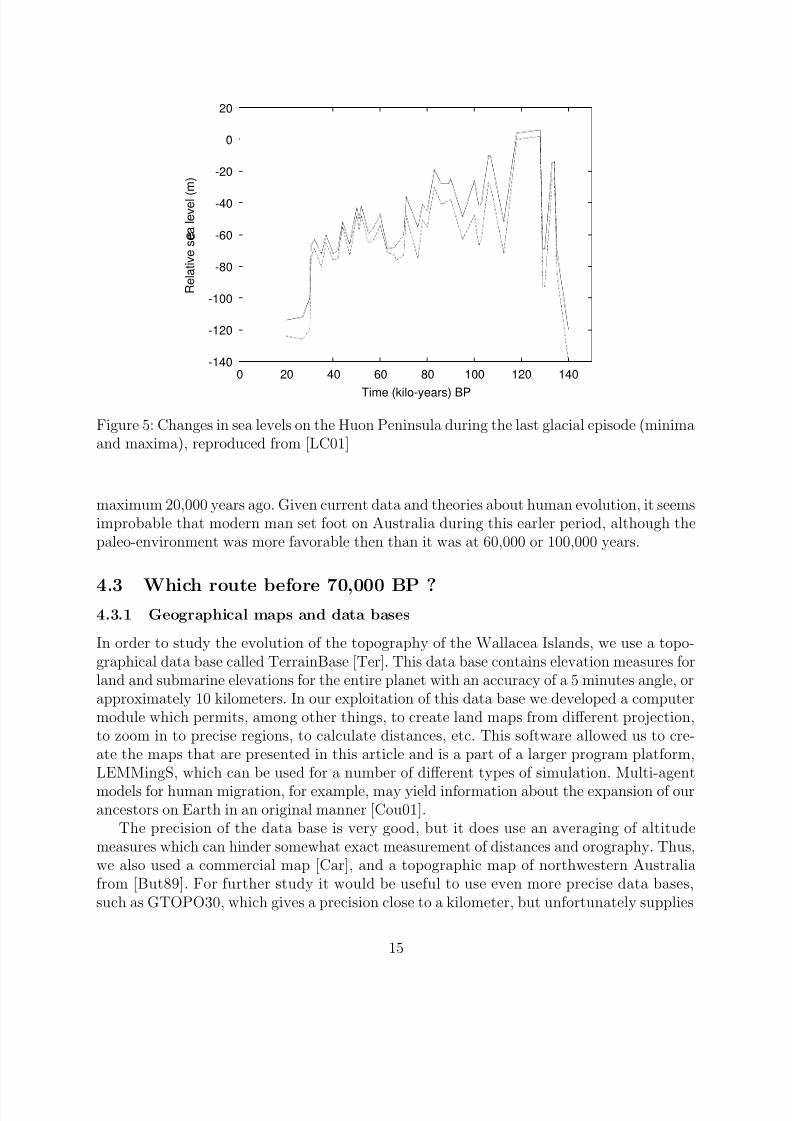
tant differences from one region to another. This is due, in fact, to local tectonic variations,with eruptions or collapses of the tectonic plaque in response to constraints exerted uponit. The comparisons of measurements taken from different regions of the world allows forthe separation of local phenomena from global modifications [LC01]. Figure 4 presents thegeneral evolution of sea levels during the last glacial episode, based on measures of oxygen 18concentration (reproduced from [BHF90], original from [Sha87]), and figure 5 the evolutionof relative sea level on the Huon Peninsula (reproduced from [LC01]).
It is important to notice a drop in sea levels around 65,000 years. Between 110,000 and65,000 BP, sea levels fluctuate around 40-50 meters under the actual level, while they arecloser to 80-90 meters after this date. This decrease is less pronounced on the Huon Peninsula.
This transition period is relevant to the passage to Australia, particularly given currentsite datings. If the passage had taken place shortly before the oldest current datings (around65,000 BP), the sea levels were close to -80 meters, while a later arrival date, around 90,000or 80,000 BP would have taken place in a much different geographical context.
As a note, one should be careful with referring to sea level variations: studies sometimesextend the very low sea levels around the Last Glacial Maximum (LGM, around 21,000 BP)to earlier periods of the last glacial episode. In fact, the dropping in sea levels was much lessmarked during the major part of this climatic event.
It should be emphasized that the very low sea levels observed before the next to lastinterglacial stage about 140,000 years ago were comparable or less than those of the glacial
14
8/12/2019 From Africa to Australia
http://slidepdf.com/reader/full/from-africa-to-australia 15/39
-140
-120
-100
-80
-60
-40
-20
0
20
0 20 40 60 80 100 120 140
R e l a t i v e s e a l e v e l ( m )
Time (kilo-years) BP
Figure 5: Changes in sea levels on the Huon Peninsula during the last glacial episode (minimaand maxima), reproduced from [LC01]
maximum 20,000 years ago. Given current data and theories about human evolution, it seemsimprobable that modern man set foot on Australia during this earler period, although thepaleo-environment was more favorable then than it was at 60,000 or 100,000 years.
4.3 Which route before 70,000 BP ?4.3.1 Geographical maps and data bases
In order to study the evolution of the topography of the Wallacea Islands, we use a topo-graphical data base called TerrainBase [Ter]. This data base contains elevation measures forland and submarine elevations for the entire planet with an accuracy of a 5 minutes angle, orapproximately 10 kilometers. In our exploitation of this data base we developed a computermodule which permits, among other things, to create land maps from different projection,to zoom in to precise regions, to calculate distances, etc. This software allowed us to cre-ate the maps that are presented in this article and is a part of a larger program platform,LEMMingS, which can be used for a number of different types of simulation. Multi-agent
models for human migration, for example, may yield information about the expansion of ourancestors on Earth in an original manner [Cou01].
The precision of the data base is very good, but it does use an averaging of altitudemeasures which can hinder somewhat exact measurement of distances and orography. Thus,we also used a commercial map [Car], and a topographic map of northwestern Australiafrom [But89]. For further study it would be useful to use even more precise data bases,such as GTOPO30, which gives a precision close to a kilometer, but unfortunately supplies
15
8/12/2019 From Africa to Australia
http://slidepdf.com/reader/full/from-africa-to-australia 16/39
topographical measures only for sites above current sea levels.
4.3.2 To see or not to see: visibility and distances
In his work, Birdsell places the minimal sea levels at the last glacial maximum (approximately
21,000 BP) and around 53,000 BP (following Chappell’s work). The available data runscounter to this second maximum, since the global level most probably did not reach morethan -80 meters. Outside of these periods, Birdsell postulates sea levels fluctuating around-50 meters. This hypothesis is verified for the periods between 100,000 and 70,000 BP, asthe data in the previous paragraph have shown. In the light of sea level data, the readingof Birdsell’s work hence suggests to us that only part of his analysis, where northern routesare favoured, applies correctly to our problem (-50m), a dropping of -150m being both toorecent and perhaps a little overestimated.
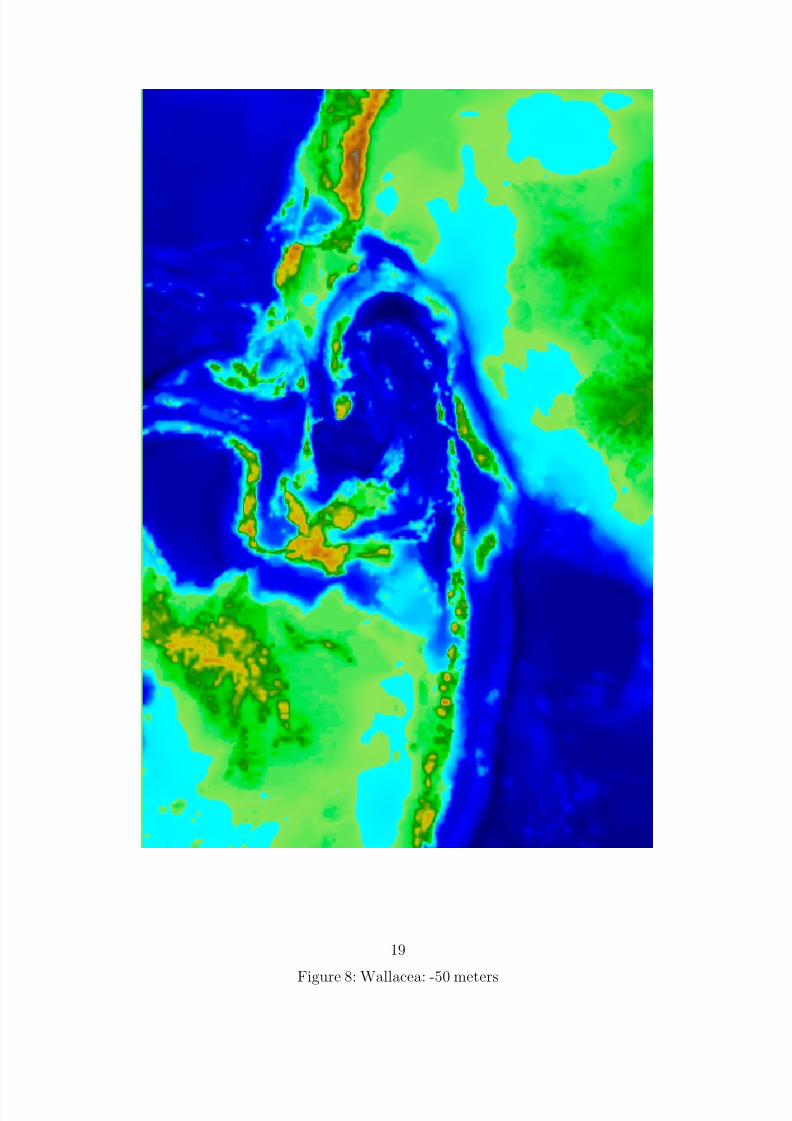
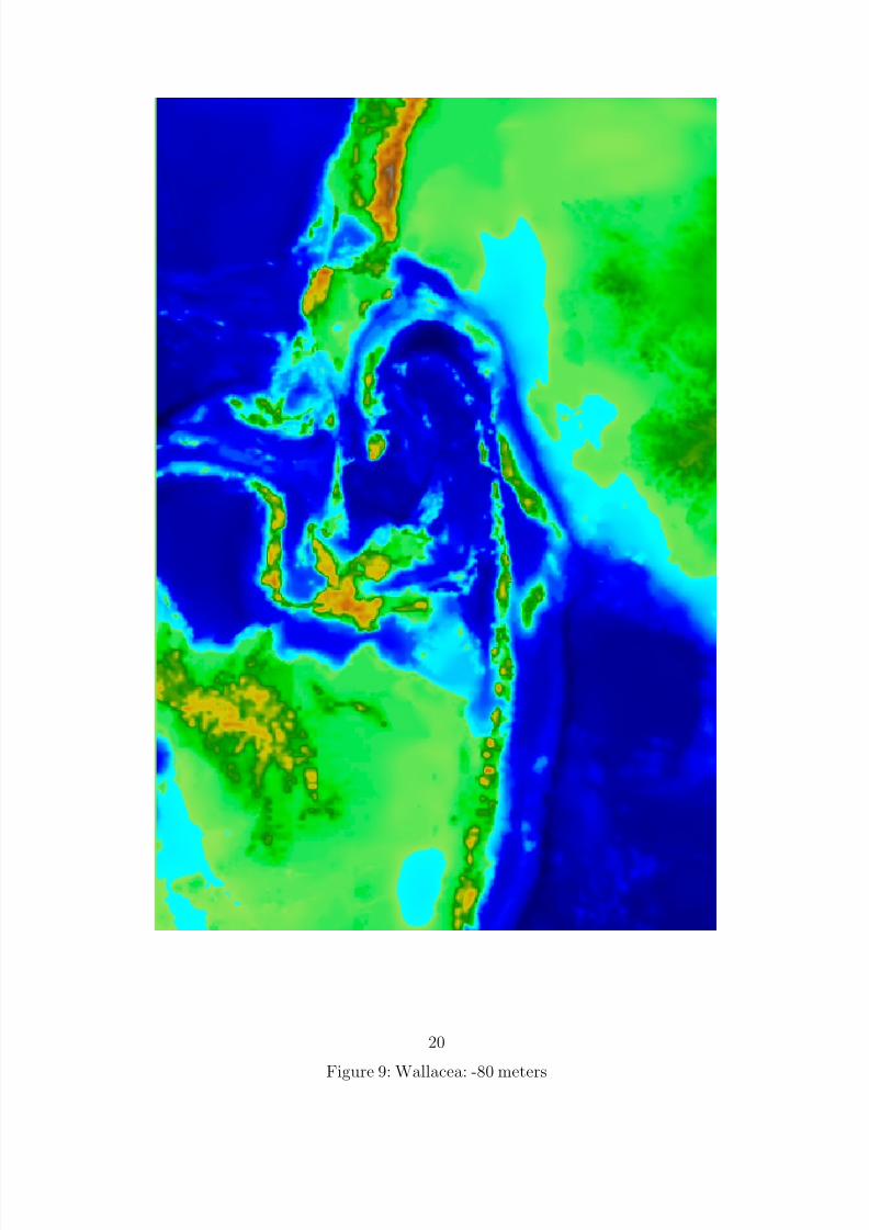
We have examined maps for the different intervals of plausible sea levels between 100,000and 60,000 BP. Figures 6, 7, 8 and 9 show the Wallacea region at different sea levels: currentlyexisting levels, -80 meters, -50 meters and 30 meters.
During the island crossings between Sunda and Sahul, depending on the distances sep-arating the islands and their altitude, the migrants must have been able to perceive someland on the horizon. In his work, Birdsell gives the altitudes and the distances for a certainnumber of islands, but does not calculate the possible visibility between them for differ-ent routes. We found several interpretations concerning this aspect: Davidson and Noble’sconclusion was that “Birdsell showed that the several possible routes all involved at leastone crossing of 90 kilometers to a target that could not have been seen at the beginning of the voyage” [DN92] (p. 135), where Bellwood estimated that “research by the late JosephBirdsell and by Geoffrey Irwin of Auckland University suggests that there were separatenorthern and southern routes, along which most islands would have been visible from theirclosest neighbors on clear days, leading from the Sunda Shelf islands towards Australia andNew Guinea.” [Bel97]. In his book, Irwin states that the route 1A from Bridsell ”providesintervisibility along an unbroken chain of islands...but the two southern sub-routes becomeblind” [Irw92] (p. 21).
It is possible to develop a formula which calculates both the probable visibility of a targetisland as a function of altitude measures taken at the point of departure and the point of arrival, and the distance between the two points. Appendix A details the trigonometricrelations which allow for these measures as well as the calculation of the angle formed bythe target island above the horizon.
In order to determine the probability for visibility, we have applied this formula to dif-
ferent pairs of islands, examining each time the situation on the departure island from shorelevel or from the best placed high point on the island. The choice of best placed high pointis taken based on maps which do not give extremely detailed topography.
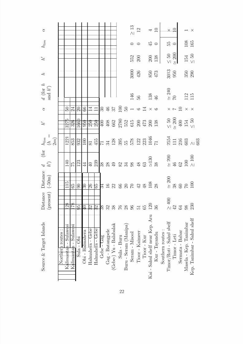
The following tables present, for a relative sea level of -50m, the distances between is-lands, the altitudes of the best choice of elevation points, and the angle of elevation abovethe horizon if the target island is visible. Data are described as follows :
16

8/12/2019 From Africa to Australia
http://slidepdf.com/reader/full/from-africa-to-australia 17/39Figure 6: Wallacea: current sea level
17

8/12/2019 From Africa to Australia
http://slidepdf.com/reader/full/from-africa-to-australia 18/39Figure 7: Wallacea: -30 meters
18
8/12/2019 From Africa to Australia
http://slidepdf.com/reader/full/from-africa-to-australia 19/39Figure 8: Wallacea: -50 meters
19
8/12/2019 From Africa to Australia
http://slidepdf.com/reader/full/from-africa-to-australia 20/39Figure 9: Wallacea: -80 meters
20
8/12/2019 From Africa to Australia
http://slidepdf.com/reader/full/from-africa-to-australia 21/39
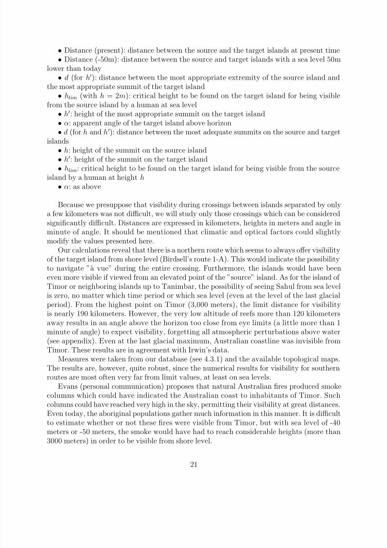
• Distance (present): distance between the source and the target islands at present time• Distance (-50m): distance between the source and target islands with a sea level 50m
lower than today• d (for h): distance between the most appropriate extremity of the source island and
the most appropriate summit of the target island
• hlim (with h = 2m): critical height to be found on the target island for being visiblefrom the source island by a human at sea level
• h: height of the most appropriate summit on the target island• α: apparent angle of the target island above horizon• d (for h and h): distance between the most adequate summits on the source and target
islands• h: height of the summit on the source island• h: height of the summit on the target island• hlim: critical height to be found on the target island for being visible from the source
island by a human at height h
• α: as above
Because we presuppose that visibility during crossings between islands separated by onlya few kilometers was not difficult, we will study only those crossings which can be consideredsignificantly difficult. Distances are expressed in kilometers, heights in meters and angle inminute of angle. It should be mentioned that climatic and optical factors could slightlymodify the values presented here.
Our calculations reveal that there is a northern route which seems to always offer visibilityof the target island from shore level (Birdsell’s route 1-A). This would indicate the possibilityto navigate ”a vue” during the entire crossing. Furthermore, the islands would have beeneven more visible if viewed from an elevated point of the ”source” island. As for the island of
Timor or neighboring islands up to Tanimbar, the possibility of seeing Sahul from sea levelis zero, no matter which time period or which sea level (even at the level of the last glacialperiod). From the highest point on Timor (3,000 meters), the limit distance for visibilityis nearly 190 kilometers. However, the very low altitude of reefs more than 120 kilometersaway results in an angle above the horizon too close from eye limits (a little more than 1minute of angle) to expect visibility, forgetting all atmospheric perturbations above water(see appendix). Even at the last glacial maximum, Australian coastline was invisible fromTimor. These results are in agreement with Irwin’s data.
Measures were taken from our database (see 4.3.1) and the available topological maps.The results are, however, quite robust, since the numerical results for visibility for southernroutes are most often very far from limit values, at least on sea levels.
Evans (personal communication) proposes that natural Australian fires produced smokecolumns which could have indicated the Australian coast to inhabitants of Timor. Suchcolumns could have reached very high in the sky, permitting their visibility at great distances.Even today, the aboriginal populations gather much information in this manner. It is difficultto estimate whether or not these fires were visible from Timor, but with sea level of -40meters or -50 meters, the smoke would have had to reach considerable heights (more than3000 meters) in order to be visible from shore level.
21
8/12/2019 From Africa to Australia
http://slidepdf.com/reader/full/from-africa-to-australia 22/39
S o u r c e &
T a r g e
t I s l a n d s
D i s t a n c e
( p r e s e n t )
D i s t a n c e
( - 5 0 m )
d
( f o r
h )
h l i m
( h
=
2 m )
h
α
d ( f o r h
a n d h )
h
h
h l i m
α
N o r t h e r n r o u t e s :
K a l i m a n t a n - S u l a w e s i
1 2 8
1 1 5
1 4 0
1 2 2 1
3 2 7 5
5 0
K a l i m a n t a n - S u l a w e s i
1 7 8
6 5
7 5
8 5 3
3 2 6
2 4
S u l a - O b i
9 5
9 0
1 2 3
9 3 2
1 6 6 0
2 0
O b i - H a l m a h e r a
4 0
3 0
4 4
1 0 0
9 5 0
6 6
H a l m a h e r a -
G e b e
3 2
2 6
4 0
8 1
2 5 0
1 4
H a l m a h e r a -
G e b e
3 2
6 5
2 3 9
4 5 5
2 5 0
1 1
G e b e - G
a g
3 8
3 4
3 8
7 1
4 0 0
3 0
G a g - B a t a n
g p e l e
3 2
1 6
2 8
3 4
4 0 8
4 6
( G e b e - ) Y u - B
a l a b a l a k
3 8
2 2
4 9
1 2 8
6 6 2
3 7
S u l a - B u
r u
7 6
6 6
8 2
3 9 5
2 7 8 0
1 0 0
B u r u - S e r a m (
M a n i p a )
2 8
2 0
3 4
5 5
5 5 2
5 0
S e r a m
- M i s o o l
9 6
7 0
9 8
5 7 8
6 1 5
1
1 4 6
3 0 0 0
5 5 2
0
≥
1 3
T i o o r - K a i
m e e r
5 1
4 2
4 8
1 2 2
2 0 0
6
5 6
4 2 6
2 0 0
0
1 2
T i o o r - K
u r
6 5
4 8
6 3
2 2 3
4 7 3
1 4
K a i - S a h u l s h e l f n e a r K e p . A r u
1 2 0
1 0 8
1 3 0
1 0 4 6
2 0 0
×
1 3 8
8 5 0
2 0 0
4 5
4
K u r - T a y a
n d u
3 6
2 8
3 8
7 1
1 3 8
6
4 6
4 7 3
1 3 8
0
1 0
S o u t h e r n r o u t e s :
T i m o r / R o t i - S a h u l s h e l f
≥
4 0 0
2 0 0
2 0 0
2 5 5 4
≤ 5 0
×
2 4 0
3 0 1 3
≤
5 0
5 5
×
T i m o r - L
e t i
4 2
3 8
4 6
1 1 1
2 0 0
7
7 0
9 5 0
2 0 0
0
1 0
S e r m a t a - B
a b a r
6 4
6 0
6 2
2 1 6
4 0 0
1 0
M a s e l a - K e p . T
a n i m b a r
9 8
7 0
1 0 0
6 0 3
1 5 4
×
1 1 2
3 5 0
1 5 4
1 0 8
1
K e p . T a n i m b a r -
S a h u l s h e l f
2 3 0
1 0 0
≥
1 0 0
≥ 6 0 3
≤ 5 0
×
1 1 5
2 9 0
≤
5 0
1 6 5
×
22
8/12/2019 From Africa to Australia
http://slidepdf.com/reader/full/from-africa-to-australia 23/39
Ha mahera
Gebe Yu
Gag
Balabalak
BatangpeleObi
Kep. Gorong
Kep. Watubela (Tioor)
Tioor
Kaimeer
Kur
Tayandu
Kep. Kai
Kep. Aru
Kalimantan
Sulawesi
Peleng
Kep. Banggai
SulaBuru Manipa
Seram
Misool
Peninda
Lombok/Sumbawa
Flores/Lomblen
Kep. Solor dan Alor
Timor/Roti
Sahul shelf
Kep. Leti
Sermata Babar
Masela
Kep. Tanimbar
Sahul shelf Bali
Figure 10: Names of islands for northern and southern routes
23
8/12/2019 From Africa to Australia
http://slidepdf.com/reader/full/from-africa-to-australia 24/39
Regarding distances, one should note the presence of several reef located between Timor/Rotiand the Australian shelf that were probably above water during lower sea level [But89] (mapp.20-21). These reefs, if they offered useful resources, would have broken the large distanceto Australia into several smaller routes and would hence have facilitated the crossing.
Sea-crossing difficulties for the routes toward PNG via the north along the Wallaceaislands and for the more southern routes toward northwest Australia do not evolve similarlywith sealevel variations. If one follows the decreasing sea levels from the interglacial episode120,000 years ago, the earlier the conquest of Australia, the easier was migration along thenorthern routes compared to passages by more southern passages. This is true for distances.As for visibility, crossings ”a vue” were possible following a northern route, even for verylow droppings of sea level. This is not the case for southern routes. We conclude, then, thatthe older the conquest of Sahul, the more likely that the first migration was toward PNG.We also add that even for a migration around 70,000 or 65,000 BP, or for later migrationswith lower sea-levels, the crossing between Timor/Roti and Australia does not seem to usas short as it has sometimes been said in the literature, and remains harder than a northernroute.
For small distances between islands, fishermen sailing a few kilometers off-shore may havebeen able to see islands not visible from their point of departure [Nicholas Evans, personalcommunication]. Nevertheless, for longer distances (tens of kilometers), this possibility doesnot apply.
5 Synthesis and discussion
5.1 An old and intentional crossing of populations from Asia
The visibility calculations given above favor a conquest of Sahul from the north via theWallacea islands, with an arrival in PNG and not along the cost of northwest Australia. Asis true for Birdsell’s proposal, this proposed crossing is not hindered by sea levels slightlylower than current levels (thus, in particular before 70,000 BP). Thus, they are even morepreferred to southern routes for which the distances to cross to reach Australia are too long,and for which visibility of target coastline is not possible.
It is possible to claim that the first migrants may have arrived very early on Sunda andwould have spent considerable time there before reaching Australia, increasing the possi-bility of repeated accidental crossings to Australia. It is for this reason that the following
paragraphs attempt to marshall supplementary arguments which favor the route via PNGand also dates before 65,000 BP (these two propositions are relatively independent).
We will also propose that the crossing were done by boat and with intention, with groupsconsciously attempting to reach a certain destination and not simply being pushed haphaz-ardly amongst the Wallacea Islands by winds or sea currents. This hypothesis is based largelyon the visibility of the destination: the groups taking to sea had a fixed goal, were able tosight their destination and did not leave the shore without knowing where they would arrive,
24
8/12/2019 From Africa to Australia
http://slidepdf.com/reader/full/from-africa-to-australia 25/39
knowing the navigational difficulties. Other migrations as migratory birds (Coco island are)
What reasons could have lead to such travels ? Ordinary reasons, like extension of fishingterritories, demographic pressure, or more exceptional events : social conflicts like steals of women (as observed in the northern territories of Australia today [Nicholas Evans, personal
communication]), or natural phenomena like volcanic eruptions (as they happened nearlyuninterrupted for the last 100,000 years in the Indonesian region and also in the north of PNG).
5.1.1 Rafts and sea currents
The current populations of Tasmania or Australia have at their disposal a wide range of navigational means. Birdsell [Bir77] provides very precise details on different types of con-structions. It would appear that these vessels are less advanced than those which would havepermitted the first crossing more than 60,000 years ago. In particular, they are not resistantenough to support crossings of more than ten kilometers, losing their ability to float after a
few hours of navigation.The crossings must have been very difficult, with many failures and loses. The chances
of success for such passages are much higher, however, if we accept that the crossings wereplanned with full intention of the sailors. Vessels specifically prepared for such crossings wouldbe more resistant and more easily handled than vessels caught by chance in the currents. Asmentioned earlier, an intentionally planned voyage would have allowed many groups to sailsimultaneously with boats tied together, increasing the number of individuals which favorsthe possibility of survival at destination. Planning would also have insured enough drinkablewater and food, in appropriate containers. Birdsell calculates approximately 30 hours arenecessary to cover 100 kilometers. It is conceivable that the early navigators could have gonewithout food and water for such a short period. However, it is difficult to claim that all partsof the crossings required such a short time. In addition, prepared food and water would beextremely useful in initial stages after arrival.
It is difficult to determine the evolution of sea currents during the last glacial episode:closing of the Torres straights and variations in sea level and tides could yield a picture muchdifferent from the one which we now have. Regarding winds, Irwin [Irw92] proposes that thecontemporary climatic pattern (and also currents) applied quite similarly to Pleistocene, andhence favoured island-hopping with predictable seasonal winds reversal and few cyclones.
5.1.2 Site locations and coastal movements
One argument for a crossing between Sunda and Sahul during a short period of time is theabsence of sites on the Wallacea Islands before 40,000 BP (Leang Burung 2 (31,000 BP) atSulawesi, Niah Cave (40,000 BP) and Tingkayu (28,000 BP) in Kalimatan) [Bow92]. Somesites may be located underwater today, but a sustained presence on these islands would mostcertainly have left more remains. The lands that emerged with the decrease in sea level aremuch smaller than those in northwest Australia for example.
25

8/12/2019 From Africa to Australia
http://slidepdf.com/reader/full/from-africa-to-australia 26/39
We have already noted the oldest Australian datings. Around 60,000 BP, evidence forthe presence of humans is found both close to the current coastline of northwest Australia,but in places that were considerably in the interior when sea level was lower (more than 100kilometers), and in the opposite direction within the Lake Mungo region. Based on such adistribution, it is not possible to conclude that the sites in the northwest are in all likelihood
the first traces left by the migrants. In addition, older sites are very likely now submergedunder water (cf. the maps given earlier). A principal question revolves around the estimationnecessary for the populations arriving in the Northern Territory or in PNG to spread to thesoutheast of Australia.
Some authors propose a very rapid expansion on the continent, in the absence of compe-tition with other humain species. In 1957, Birdsell attempted to model the expansion of asmall founding group and concludes that some thousands of years would have been sufficientto occupy the Australian continent with an already considerable density [Bir57]. Overall theexpansion went from the north to the south.Bowdler [Bow77] proposes a different scenario and criticizes some of Birdsell’s arguments,in particular his optimism about the survival capacity of small groups of immigrants andthe claim that the aborigines population of this century reflected the degree of maximumsaturation of the Australian environment. Bowdler defends the hypothesis of an expansionalong the Sahul coastline, which was subsequently extended by following the waterways, andreaching, for example, Lake Mungo. Adaptation to non coastal regions or areas far fromrivers would have taken place much later, through a long and necessary adaptation to otherliving conditions. This hypothesis fits best with current ideas about coastal migrations fromAfrica since this adaptation already present in Africa 120,000 years ago would find a naturalprolongation. Conquest of the interior regions of Australia must have been much slower andperhaps the intentional use of fire for hunting purposes had not even begun when the first
immigrants arrived whose principal food source was the ocean. The consequence of such ascenario forces us to push back the date of the arrival of the first immigrants, given thedifferent paleontological evidence which appear to date sites located far from the coastlineand indicating the use of fire in Australia at close to 60,000 years ago.
An arrival by the extreme northwest PNG requires a longer time span in order to obtainan expansion in Australia than an arrival by the northern territories. However we have arguedthat the first human groups could have been more numerous than those accidentally driftingto Australia.
5.1.3 Paleoclimates and evidence of animal extinction
We have already seen that the oldest evidence of the use of fire and extinction of animalspecies dates around 60,000 BP. Animal extinction can result from both modification of theenvironment (caused by a human presence or not) and hunting. A plausible scenario is amixture of both these factors, with an ecological stress caused by a more arid climate (witha first maximum at 70,000 BP [Ada97]), reinforced by human actions. Even if modificationsof the environment were rapid, an important human population density is required to justifyextinctions of a species upon the entire continent and profound modifications of the environ-
26
8/12/2019 From Africa to Australia
http://slidepdf.com/reader/full/from-africa-to-australia 27/39
ment. Once again, the hypothesis of an adaptation to coastline living conditions precludesthat this type of situation took place shortly after the arrival of the first immigrants. If thedates close to 60,000 BP for animal extinctions or climatic modification are confirmed, thenthe first arrival must have happened long before this date.
5.1.4 Genetic data
Analysis of nuclear, mitochondrial and Y chromosome DNA
During the last ten years, with the development of genetic sequencing, studies have beencarried out on the relationships between different human populations, in particular PNG,Australian and African populations, which interest us here.
Our hypothesis of a precocious arrival in PNG could find an echo in an important ge-netic drift of some PNG and Australian populations (if the migrations were subsequentlyextended towards Australia). Subsequent migrations could have masked this drift unless theoldest populations had entirely disappeared, leaving no genetic trace. The recent arrival of
Austronesians (less than 5,000 years ago) has had a serious impact in PNG, but this concernsprimarily the coastline populations, the Highland populations being less affected.
A study by Redd and Stoneking on the mitochondrial DNA (hypervariable segments HVI and HV II of the control region) leads to this conclusion: the results from PNG Highlandssuggest a very old arrival, followed by an isolation of these populations with a genetic drift.Coalescence time depth for the Highland populations is estimated at approximately 80,000to 122,000 BP (depending on the different sequenced genetic clusters) [RS99]. One shouldbe careful manipulating these date that they relate to genetic mutations, which are not cor-related in time to movements of population. But, even with shifts of several thousand years,the great antiquity of these dates are in agreement with our proposal. However, the variouspublications on this subject are still quite contradictory and a firm conclusion is perhapspremature.
Just as mtDNA allows to trace maternal lineages and mutations, the Y chromosome of-fers a possibility of investigating paternal lineages. Results from Underhill and al. [UPL+01]confirm the scenario of a migration from East Africa toward Australia and PNG, with thepresence of the RPS4Y/M216 mutation (found in Asia, Australo-Melanesia and North Amer-ica). This mutation is supposed to have occured en-route to southeast Asia, while the priormutation M168 (common to all not exclusively African Y-chromosome) may have appearedin East Africa 50,000 to 40,000 years ago, with a 95 percent confidence interval of (31,000-79,000). As said by the author, this age is young in comparison with some archaeological
findings, and even more with our proposals.
Haphazard sea crossings to northwest Australia and genetic drift
The preceding paragraph illustrates how migration history can be written in genes (andalso, perhaps, be masked by other subsequent migrations). As indicated above, many authorshave examined the possibility of an extremely reduced number of individuals arriving on the
27

8/12/2019 From Africa to Australia
http://slidepdf.com/reader/full/from-africa-to-australia 28/39
Australian shores, carried on their rafts from the Timor coast. Such slow arrival of fewindividuals in different regions would have led to a genetic bottleneck before demographicexpansion occurred. Jones insists that “any next arrival on the Australian coast breedinginto the existing populations would have provided great genetic benefits” [Jon89], p.756.The current genetic consequences of such an arrival have apparently not yet been studied,
but it seems reasonable that such a minimal genetic stock at the base of the Australianpopulation would reveal itself today by a considerable isolation of Australians vis a vis otherpopulations. This does not seem to be the case based upon current studies [SW89]. However,the first immigrants might have been fully replaced by later populations, leaving no genetictraces.
An intentional arrival of a large number of individuals would have also brought on agenetic drift as described before, although less important, and perhaps would have resultedin the genetic drift of the Highland PNG mentioned by Redd and Stoneking. New geneticstudies and simulations should yield important data relevant to this question.
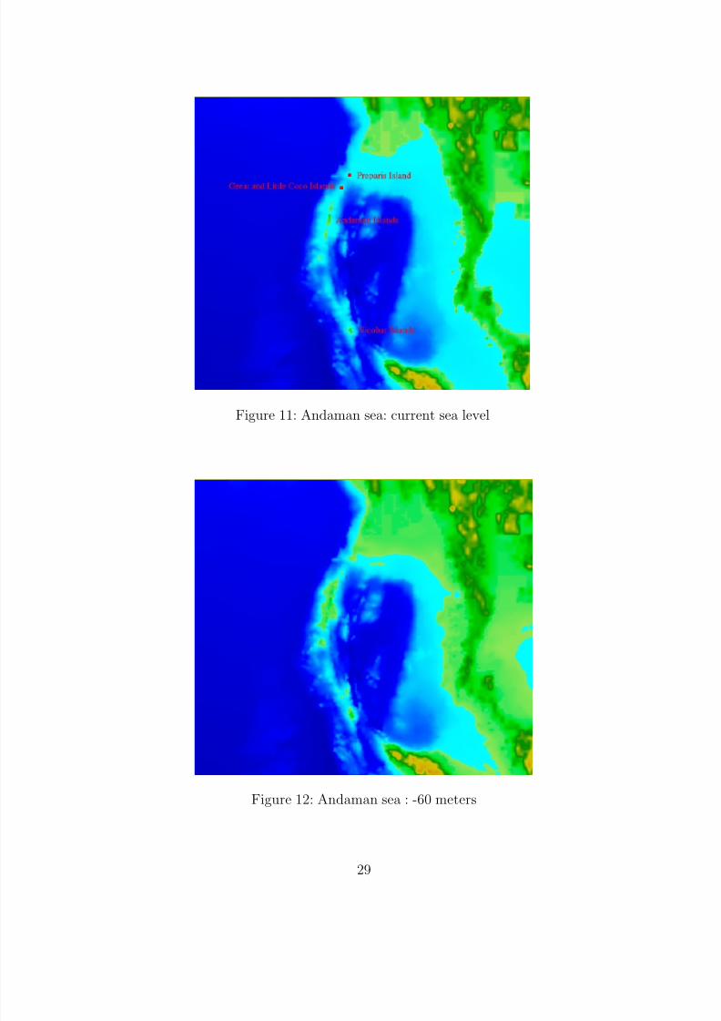
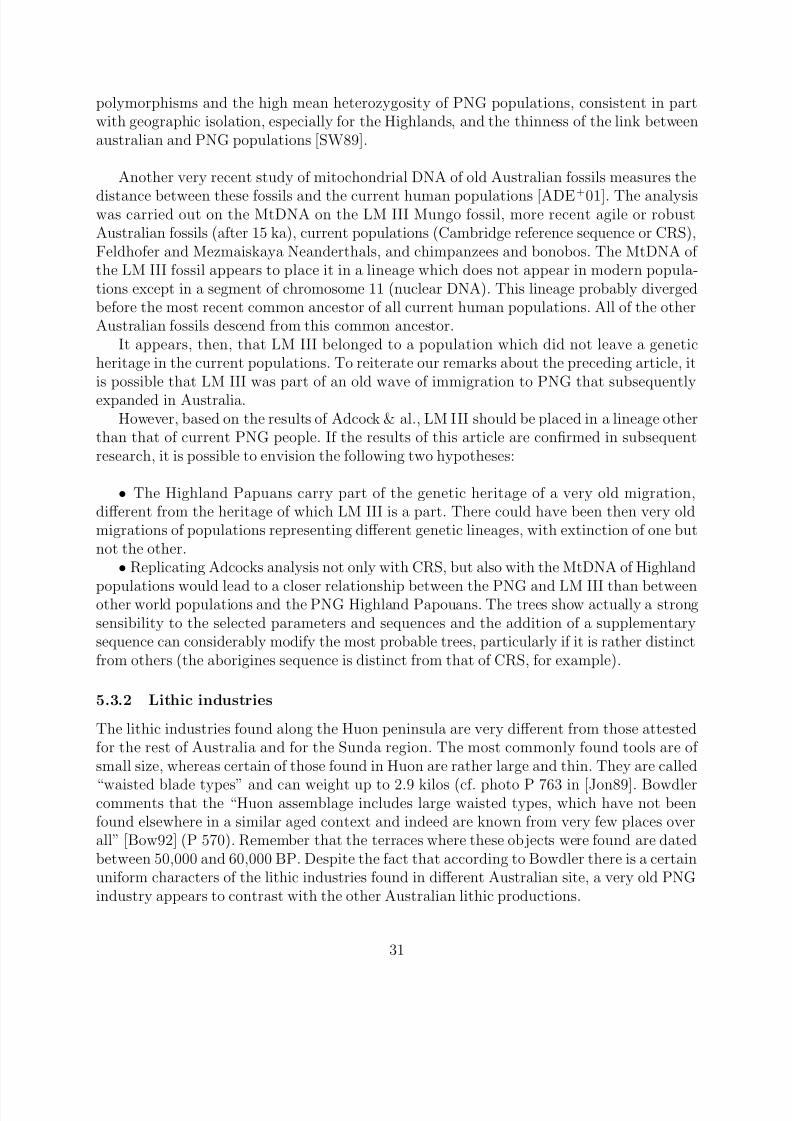
5.2 The case of the Andaman islandsIslands-hopping and use of boats have been intensively debated for decades in the Indone-sian region. Since one of our goals is to relate the Australian conquest to a wider patternfinding its roots in Africa, it is interesting to look at other possibilities of sea-voyaging beforereaching the Wallacea islands. Such occasions are rare, but the case of Andaman and Nicobarislands is worth being investigated. Located in the Gulf of Bengal, several hundred kilometersfar from the continent, they constitute some of the emerged summits of a large submarinemountain range. With the decrease in sea level during the last glacial episode, the expansionof the continental shelf and the emergence of the mountain range reduced significantly thedistances to an odd 70 kilometers wide passage in the north of the Andaman islands (for a
-60 meters relative sea level), the current islands of Preparis and Great Coco being locatedat the two closest extremity of this sea-crossing.
Application of our formulas in this case, with an estimated current height for the islandsof around 100 meters leads to the visibility of Great Coco Islands from an elevated point of the Preparis island (with an angle above horizon of around 10 minutes of angle). Popula-tions migrating along the coastline may have seen these islands and tried to reach them, asthey did in the Wallacea region later. Flights of migratory birds may also have been observed.
The figures 11 and 12 depict the current situation and the paleo-geography with a -60meters relative sea-level.
On going studies of Andamanese DNA favour an early migration to the Andaman islands.The DNA extracted from Onge populations, with a mutation on chromosome Y connectingthese tribes to african populations, suggest a very ancient origin of 50,000 to 60,000 years,while the currently sequenced DNA from Jarawa populations may indicate an even greaterantiquity of these very isolated populations [Lalji Singh, personal communication].
The case of Nicobar islands falls in a different category than Andaman islands, since theywere never visible from either the Andaman islands or the continent’s shell (more than 200
28
8/12/2019 From Africa to Australia
http://slidepdf.com/reader/full/from-africa-to-australia 29/39
Figure 11: Andaman sea: current sea level
Figure 12: Andaman sea : -60 meters
29

8/12/2019 From Africa to Australia
http://slidepdf.com/reader/full/from-africa-to-australia 30/39
kilometers far). Our point of intentional crossing would predict that DNA analysis of theseindigenous populations would lead to different patterns than Andamanese populations. Atleast can we say that the linguistic pattern of these islands follows this proposal, since theAndamanese languages are unrelated to any neighboring languages, when the Nicobareselanguages are undoubtedly Austroasiatic.
If true, these hypotheses and data on Andaman islands would fit in a very significant wayto our hypothesis of an ancient sea-voyaging culture acquired long before reaching Indonesia.It would increase the possibility of intentional sea-crossings between the numerous islandsof Wallacea, by providing an earlier example of such travel.
5.3 Different scenarios for the peopling of Australia
If one accepts the fact that there was a first migration to PNG, it is important to ask howAustralia was populated. Was the conquest of Australia undertaken from PNG following thefirst migration, or was it the result of other subsequent migrations?
The current population of Australia results probably from many different migrations atdifferent periods. After the initial migration, others must have occurred either from PNG orfrom other southern routes, particularly after 60,000 when sea level dropped considerably orwith progresses in sailing. A number of hypotheses can be stated:
• The first migrations to PNG did not spread to Australia. Australia was populated byother migrations, either from later migrations to PNG, or directly from the northwest shoresof Australia, or both simultaneously
• The first emigrants to PNG colonized Australia at the same time. They could havebeen replaced by subsequent migrations, or have mixed with earlier arrivals.
Different arguments can be given in the attempt to draw the profile of these early migra-tions.
5.3.1 Ancient DNA
Bearing in mind some reservations about the contradictions in current genetic studies, thereare a number of points which seem relevant to understanding migration into Australia.
In Redd and Stoneking’s study, a clear genetic separation was observed between, onthe one hand, the Highland PNG populations and the Australian aborigines, and on theother, between the Highland PNG populations and the rest of the world. Such a separa-tion would be compatible with a very old migration out of Africa. Subsequent migrations
would have served as the basis of current populations, including Australian aborigines. It is,then, possible that the first arrivals to PNG were extremely isolated. A second possibilityis that an expansion of these populations in Australia was subsequently replaced by newwaves of immigrants, with genetic heritage being preserved only in the PNG Highlands.Redd and Stoneking suggest, in fact, a genetic proximity between the Australian aborigines’populations and those of the Indian subcontinent, with dates of genetic divergence beingvery recent (a few thousands years). Other articles have stated the large number of private
30
8/12/2019 From Africa to Australia
http://slidepdf.com/reader/full/from-africa-to-australia 31/39
polymorphisms and the high mean heterozygosity of PNG populations, consistent in partwith geographic isolation, especially for the Highlands, and the thinness of the link betweenaustralian and PNG populations [SW89].
Another very recent study of mitochondrial DNA of old Australian fossils measures the
distance between these fossils and the current human populations [ADE+
01]. The analysiswas carried out on the MtDNA on the LM III Mungo fossil, more recent agile or robustAustralian fossils (after 15 ka), current populations (Cambridge reference sequence or CRS),Feldhofer and Mezmaiskaya Neanderthals, and chimpanzees and bonobos. The MtDNA of the LM III fossil appears to place it in a lineage which does not appear in modern popula-tions except in a segment of chromosome 11 (nuclear DNA). This lineage probably divergedbefore the most recent common ancestor of all current human populations. All of the otherAustralian fossils descend from this common ancestor.
It appears, then, that LM III belonged to a population which did not leave a geneticheritage in the current populations. To reiterate our remarks about the preceding article, itis possible that LM III was part of an old wave of immigration to PNG that subsequentlyexpanded in Australia.
However, based on the results of Adcock & al., LM III should be placed in a lineage otherthan that of current PNG people. If the results of this article are confirmed in subsequentresearch, it is possible to envision the following two hypotheses:
• The Highland Papuans carry part of the genetic heritage of a very old migration,different from the heritage of which LM III is a part. There could have been then very oldmigrations of populations representing different genetic lineages, with extinction of one butnot the other.
• Replicating Adcocks analysis not only with CRS, but also with the MtDNA of Highland
populations would lead to a closer relationship between the PNG and LM III than betweenother world populations and the PNG Highland Papouans. The trees show actually a strongsensibility to the selected parameters and sequences and the addition of a supplementarysequence can considerably modify the most probable trees, particularly if it is rather distinctfrom others (the aborigines sequence is distinct from that of CRS, for example).
5.3.2 Lithic industries
The lithic industries found along the Huon peninsula are very different from those attestedfor the rest of Australia and for the Sunda region. The most commonly found tools are of small size, whereas certain of those found in Huon are rather large and thin. They are called
“waisted blade types” and can weight up to 2.9 kilos (cf. photo P 763 in [Jon89]. Bowdlercomments that the “Huon assemblage includes large waisted types, which have not beenfound elsewhere in a similar aged context and indeed are known from very few places overall” [Bow92] (P 570). Remember that the terraces where these objects were found are datedbetween 50,000 and 60,000 BP. Despite the fact that according to Bowdler there is a certainuniform characters of the lithic industries found in different Australian site, a very old PNGindustry appears to contrast with the other Australian lithic productions.
31
8/12/2019 From Africa to Australia
http://slidepdf.com/reader/full/from-africa-to-australia 32/39
5.3.3 Linguistic and cultural elements in Australia and PNG
As is true for current genetic evidence, the findings concerning cultural elements should betaken with some reserve. Given that the period of first migrations is very old, cultural andtechnological traces could have totally disappeared. We have already pointed out that abo-rigines and Tasmanian boats could not sail the expanses of water that were crossed morethan 60,000 years ago. Nevertheless, it is worthwhile noting some evidence that can enlightenour knowledge of Sahul’s old population.
Linguistic data
The study of the genetic relationships between Australian languages and languages outsideof Australia has not yet yielded convincing results. All of the affiliations proposed over thelast 150 years are extremely precarious and following Dixon, only the hypothesized rela-tionship between Australian languages and Dravidian languages was deserving attention 1
[Dix80]. This runs in parallel to Redd and Stonekings results pointed out earlier. Foley lookedspecifically at the relations between PNG languages of the Eastern Highland and Australian
language by examining possible cognate words between the two language families [Fol86]. Heconcludes, however, that the number of correlations is too weak to draw clear conclusions.Thus, it is difficult to give an adequate picture of the linguistic relationship between PNGand Australians. It seems that the time depth considered (even if PNG and Australia werestill connected about 10,000 years ago) is too large for linguistic data to be useful.
Burial rites
An interesting remark made by Thorne concerns the burial site of LM III fossil (at LakeMungo). When asked whether the skeletal remains are those of a man or of a woman, manyAustralian aborigines answer without hesitation that the way in which the skeleton is po-sitioned (fingers intertwined and hands on the lower abdomen) corresponds to the ritualposition used today for men. It is surprising that such a cultural convention should havesurvived close to 60,000 years. This gives additional indication that cultural elements char-acteristic of the period and the populations of LM III could have been transferred during thecourse of different migrations. Even if these populations were replaced, as we argued above,cultural conventions could have been exchanged during contact. It would be interesting inthis respect to compare PNG and aborigines burial sites to ascertain whether or not simi-larities emerge.
Adaptation to rain forests
The Australian ecological environment contrasts greatly with that of PNG. This is truenow and was probably true during the Pleistocene era. PNG has a type of rain forest thatis absent in Australia. In the Highlands middle or high mountain, altitude forest environ-ments are found. Adaptation to life in the equatorial forest must have required quite a longtime. We can mention the sites discovered in New Ireland [AGJW88] and in New England
1Dixon himself does not hold this position any more
32
8/12/2019 From Africa to Australia
http://slidepdf.com/reader/full/from-africa-to-australia 33/39
[PG94]. These sites, dated between 30,000 and 40,000 BP provide an example of a very oldadaptation to an equatorial forest of low altitude, despite that fact as Pavlides points out,rain forests have until recently been considered empty of human population before the endof the Holocene era.
An explanation for the genetic isolation of the PNG Highland (and in fact for their overall
isolation in general) can be found in a successful adaptation to a rain forest and subsequentlyto the Highlands (cf. the more adequate lithical industries, see above the tools on the Huonpeninsula and below, Groubes hypothesis concerning their usage). This progressive adapta-tion would have kept them separated from other populations migrating along the coastline.A division could have taken place among these first emigrants, with one part moving pro-gressively into the PNG interior, while the others continued their route towards Australiaby exploiting sea resources.
5.4 Some hypotheses about the date of language emergence
To conclude our discussion, it is tempting to make some hypotheses about the role thatlanguage could have played during the first migrations.
Use of an elaborate communication system could have been beneficial to the first emi-grants in a number of ways. First of all, and in agreement with the hypothesis concerningan intentionally organized crossing, it would have permitted individuals to better plan theirmovements, and to agree about the construction of boats and their usage. This languagewould have allowed the transmission, the amelioration and the long term establishment of abody of knowledge necessary for the constructions of such vessels. Davidson and Noble evenestimate that “language is necessary for the building of a boat and for the emerging pictureof the symbolic and representational abilities of the earliest people in the Australian region”[DN92] p.140.
Finally, and perhaps more hypothetically, language might have played an important rolein elaborating the reasons which pushed the emigrants to move from island to island. Forexample, beliefs and myths could have encouraged individuals to seek new lands even whenthe currently occupied land provided sufficient resources. The hypothesis of rapid movementmay correlate with the lack of old archeological sites on the Wallacea islands (compared toAustralia), with longer periods of occupation of these islands increasing the possibility of finding sites. The vast number of islands to cross corroborates this as well (as mentionedearly it is possible to argue that this number of islands simply required a very long time of migration). Of course, these hypotheses are highly tenuous and our goal in discussing themis to suggest original, albeit provocative, ideas.
Before concluding and as a follow up on the ideas concerning an already sophisticatedlanguage, it seems important to insist on the probably very culturally developed emigrantsto Sahul. The use of pigments seems confirmed on the Nauwalabila site, dating from over50,000 years ago. In Mungo, traces of red ochre in the burial grounds of LM III, and even thepresence of this burial site bears witness to a consciousness of death and some metaphysicalnotions, and this earlier than 60,000 BP. A developed language offers a very strong meansof transmitting concepts, not to mention the necessary means for the original elaboration of
33
8/12/2019 From Africa to Australia
http://slidepdf.com/reader/full/from-africa-to-australia 34/39
such concepts.Many studies have insisted on the probable development of PNG populations many tens
of thousands of years ago. Groube et al. analyze tools from the Huon peninsula (see above),and propose that they were used to cut down trees on the edge of forests. Bringing lightto the soil would have favored the growth and expansion of various kinds of consumable
plants, such as sugar cane or bananas [GCMP86]. This supports the idea of a very old andintentional modification of the environment (as fire in Australia) to be compared by Jonesto development in Europe: “. . . it is quite astonishing to consider that people in New Guineawere using such tools and modifying their environment in such a way at a time when therewere still Neanderthal people occupying western Europe” [Jon92] (p. 297).
6 Conclusion
During the course of this article, we have attempted to develop the following ideas: (i) thefirst migration to old Greater Australia was headed towards PNG and not towards current
Australia, (ii) this first migration was very old, between 70,000 and 100,000 BP, (iii) themigration was intentional, the emigrants crossing the islands could see the successive sites of colonization, their behavior is the result of cultural and technological developments obtainedduring the course of migration outside of Africa, (iv) an already sophisticated language couldhave played a role in the migration, assuring the transmission of culture and technologicalknowledge between humans, (v) this migration was followed by other migrations, either bythe same or by other routes, with perhaps isolation of the first arrivals from subsequentarrivals in PNG. These hypotheses can be considered independently, but their combinationincreases the overall coherence.
Future discoveries of older site in Australia or in PNG could strengthen or weaken thesehypotheses. In particular, few excavations have been undertaken in PNG and our propositionswould imply that important information may be found in the northwestern part of the island.Pushing back the dates of first human presence would permit a finer understanding of thecondition inherent in the Out of Africa theory and to better compare the expansion of modernman to Asia and to Europe, in particular from the point of view of cultural and technologicalcharacteristics of the populations. The very old use of red ochre, burial sites such as LM IIIin Mungo, or even the old development of PNG populations are particularly good pieces of evidence for an ancient symbolic life, with a rich cultural dimension and probably with asophisticated language underlying it.
34

8/12/2019 From Africa to Australia
http://slidepdf.com/reader/full/from-africa-to-australia 35/39
ab
c
R
h
h’
R=6378 km
S2
S1
O
d
d = distance entre S1 et S2
Figure 13: Tangential look at the surface of the glove
Appendix A. Calculus of visibility between two points
With our knowledge of the topographic of the Wallacea region, it is possible to evaluatewhether or not a point of arrival was visible from a point of departure. Figure 11 shows asimple modelling of an individual at an altitude h on an island or on a boat and looking
out to sea. We examine the possibility of perceiving an element situated at a distance d andelevated at a height h. To do this, we presuppose that the limit condition is a tangential lookat the surface of the glove, taking into consideration that Earth is round.
Two trigonometrical relations in the two rectangular triangles that appear in Figure 9lead to two formula: cos(a) = R
R+h et cos(b) = R
R+h. If the distance d is small, the angles a
and b are small. By linearizing the two cosinus, we obtain (if h and h neglected comparedto R):
a =
2h
R et b =
2h
R
With d = cR and c = a + b, we arrive at the relation:
d =√
2R(√ h +
√ h)
Until now, we have presupposed that the propagation of light rays was rectilinear. Thisis not the case however due to the structure of the atmosphere which brings a refraction andcurving of the rays. To take account of this, it is necessary to modify the constant
√ 2R by
considering an effective radius superior to the earth radius by about a 4/3 ratio (the value
35

8/12/2019 From Africa to Australia
http://slidepdf.com/reader/full/from-africa-to-australia 36/39
for radio waves). The numerical application, with h, h in meters and d in kilometers givesthe relation:
d = 4.12(√ h +
√ h)
This formula is used to calculate visibility by the French navigation services [ServiceHydrographique et Oceanographique de la Marine, personal communication]. Only the nu-merical value changes, since it is estimated at 3.85 for a mean value of ray refraction by theatmosphere (the refraction layer can be more or less high, depending on the characteristicsof the atmospheric blanket).
In this calculation we suppose perfect visibility and ignore water vapour absorption,which is more pronounced at sea than on land and which can diminish distance of visibility.For an observer situated at altitude h, is would be possible to perceive land at a distanced if his elevation h is superior to the limit value h
lim = ( d
3.85 −
√ h)2. This constitutes the
optimal case.The condition limit is not at all pertinent for taking into account the possibility of
sighting a target island. The island must be high enough on the horizon to be perceived. The
resolution capacity of the human eye is around 1 minutes of angle. A superior value (largeenough) is required in order for the target to be visible. We can calculate roughly the angleof elevation above the horizon of the target using the parameters d, h and h. The formula isas follows (with, as usual, some linearization due to the weak angles a and b):
α = arctan
h − hlim
d
Where α is the expected angle expressed in radians, and hlim the limit value previouslycalculated.
36

8/12/2019 From Africa to Australia
http://slidepdf.com/reader/full/from-africa-to-australia 37/39
References
[Ada97] J.M. Adams. Global land environments since the last interglacial. Oak Ridge National Labora-tory, TN, USA. http://www.esd.ornl.gov/ern/qen/nerc.html, 1997.
[ADE+01] Gregory J. Adcock, Elizabeth S. Dennis, Simon Easteal, Gavin A. Huttley, Lars S. Jermiin,W. James Peacock, and Alan Thorne. Mitochondrial dna sequences in ancient australians:
Implications for modern humans origins. Proc. Natl. Acad. Sci. USA, 98(2):537–542, January16 2001.
[AGJW88] Jim Allen, Chris Gosden, Rhys Jones, and J. Peter White. Pleistocene dates for the humanoccupation of new ireland, northern melanesia. Nature , 331:707–709, 25 February 1988.
[All94] Jim Allen. Radiocarbon determinations, luminescence dating and australian archaeology. An-tiquity , pages 339–43, 1994.
[Bel97] Peter Bellwood. Ancient seafarers. Archaeology , 50(2), March/April 1997.
[BHF90] Edouard Bard, Bruno Hamelin, and Richard G. Fairbanks. U-th ages obtained by mass spectrom-etry in corals from barbados: sea level during the past 130,000 years. Nature , 346(6283):456–458,2nd August 1990.
[Bir57] J. B. Birdsell. Some population problems involving pleistocene man. Cold Spring Harbor Sym-posium on Quantitative Biology , 122:47–69, 1957.
[Bir77] J.B. Birdsell. Sunda and Sahul : Prehistoric Studies in Southeast Asia, Melanesia and Australia ,chapter The recalibration of a paradigm for the first peopling of Greater Australia, pages 113–167. London:Academic Press, 1977.
[Bow77] Sandra Bowdler. Sunda and Sahul : Prehistoric Studies in Southeast Asia, Melanesia and Aus-tralia , chapter The coastal colonization of Australia, pages 205–246. London:Academic Press,1977.
[Bow92] Sandra Bowdler. The evolution and dispersal of modern humans in Asia , chapter Homo Sapiensin Southeast Asia and the Antipodes, pages 559–588. Tokyo: Hokusen-Sha, 1992.
[But89] Noel Butlin. The palaeoeconomic history of aboriginal migration. Australian Economic History
Review , 29(2):3–56, 1989.
[Cal76] J.H. Calaby. The origins of the Australians , chapter Some biogeographical factors relevant tothe Pleistocene movement of man to Australasia, pages 23–28. Canberra: Australian Instituteof Aboriginal Studies, 1976.
[Car] Carte continentale indonesie est, n. 33286. Monde Carte, Euro-Carte.
[Cha74] J. Chappell. Geology of coral terraces, huon peninsula, new guinea: a study of quaternary tectonicmovements and sea-level changes. Bulletin of the Geological Society of America , 85:553–570, 1974.
[COM+94] J. Chappel, A. Omura, M. McCulloch, T. Esat, Y. Ota, and J. Pandolfi. Study on coral reef terraces of the Huon Peninsula, Papua New Guinea: establishment of Quaternary sea level and tectonic history , chapter Revised Late Quaternary sea levels between 70 and 30 ka from coralterraces at Huon Peninsula, pages 155–165. Yokohama: Department of Geography, YokohamaNational University, 1994.
[Cou01] Christophe Coupe. Migrations humaines prehistoriques, modelisations et aspects informatiques.submitted to Techniques et Sciences Informatiques (numero special Vie artificielle), 2001.
[CSMP93] Luigi L. Cavalli-Sforza, Paolo Menozzi, and Alberto Piazza. Demic expansions and humanevolution. Science , 259:639–646, 29 January 1993.
[CSW87] R. Cann, M. Stoneking, and A. Wilson. Mitochondrial dna and human evolution. Nature ,325:31–36, 1987.
37

8/12/2019 From Africa to Australia
http://slidepdf.com/reader/full/from-africa-to-australia 38/39
[Dix80] R.M.W. Dixon. The Languages of Australia . Cambridge Language Surveys. Cambridge Univer-sity Press, 1980.
[DN92] Iain Davidson and William Noble. Why the first colonisation of the australian region is theearliest evidence of modern human behaviour. Archaeology in Oceania , 27, 1992.
[Fol86] William A. Foley. The papuan languages of New Guinea , chapter Papuan languages and New
Guinea prehistory. Cambridge University Press, 1986.[FPH96] R.L.K. Fullagar, D.M. Price, and L.M. Head. Early human occupation of northern australia: ar-
chaeology and thermoluminescence dating of jinmium rockshelter, northern territory. Antiquity ,70:751–773, 1996.
[GCMP86] L. Groube, J. Chappell, J. Muke, and D. Price. A 40,000 year-old human occupation site athuon peninsula, papua new guinea. Nature , 324:453–455, 1986.
[Irw92] Geoffrey Irwin. The prehistoric exploration and colonisation of the Pacific . Cambridge UniversityPress, 1992.
[JMF+99] B.J. Johnson, G.H Miller, M.L. Fogel, J.W. Magee, M.K. Gagan, and A.R. Chivas. 65,000years of vegetation change in central australia and the australian summer monsoon. Science ,284:1150–52, 14 May 1999.
[Jon89] Rhys Jones. The human revolution: Behavioural and biological perspectives on the origins of modern humans , chapter East of Wallace’s Line: Issues and problems in the colonization of theAustralian continent, pages 743–782. Edinburgh: Edinburgh University Press, 1989.
[Jon92] Rhys Jones. Continuity or replacement: Controversies in Homo Sapiens Evolution , chapter Thehuman colonization of the Australian continent, pages 289–301. Rotterdam: A.A. Balkema, 1992.
[Kin93] J. Kingdon. Self-Made Man and his Undoing . Simon and Schuster, London, 1993.
[Kle99] Richard G. Klein. The Human Career, Human Biological and Cultural Origins . The Universityof Chicago Press: Chicago and London, 1999.
[LC01] Kurt Lambeck and John Chappell. Sea level cahnge through the last glacial cycle. Science ,292:679–686, 27 April 2001.
[LF94] Marta Mirazon Lahr and Robert Foley. Multiple dispersals and modern human origins. Evolu-tionary Anthropology , 3:48–60, 1994.
[MMJ+99] Giffod H. Miller, John W. Magee, Beverly J. Johnson, Marilyn L. Fogel, Nigel A. Spooner,Malcom T. McCulloch, and Linda K. Ayliffe. Pleistocene extinction of genyornis newtoni: Humanimpact on australian megafauna. Science , 283:205–208, 8 January 1999.
[MST76] N. McArthur, I. W. Saunders, and R.L. Tweedie. Small population isolates: a micro-simulationstudy. Journal of the Polynesian Society , 85:307–326, 1976.
[Mur84] Peter Murray. Quaternary extinctions: A prehistoric revolution , chapter Extinctions Downunder:A Bestiary of Extinct Australian Late Pleistocene Monotremes and Marsupials, pages 600–628.Tucson: University of Arizona Press., 1984.
[OA98] J. O’Connell and J. Allen. When did humans first arrive in greater australia and why it is
important to know ? Evolutionary Anthropology , 7:132–46, 1998.[PG94] Christina Pavlides and Chris Gosden. 35,000-year-old sites in the rainforests of west new britain,
papua new guinea. Antiquity , 68:604–10, 1994.
[RBO+98] R.G Roberts, M. Bird, J. Olley, R. Galbraith, E. Lawson, G. Laslett, H. Yoshida, R. Jones,R.L.K. Fullagar, G. Jacobsen, and Q. Hua. Optical and radiocarbon dating at jinmium rockshelter in northern australia. Nature , 393:358–362, 1998.
[RJS90] Richard G. Roberts, Rhys Jones, and M.A. Smith. Thermoluminescence dating of a 50,000year-old human occupation site in northen australia. Nature , 345:153–156, 1990.
38

8/12/2019 From Africa to Australia
http://slidepdf.com/reader/full/from-africa-to-australia 39/39
[RJS94a] Richard G. Roberts, Rhys Jones, and M.A. Smith. Beyond the radiocarbon barrier in australianprehistory. Antiquity , 68:611–16, 1994.
[RJS+94b] Richard G. Roberts, Rhys Jones, Nigle A. Spooner, M.J. Head, Andrew S. Murray, and M.A.Smith. The human colonisation of australia: optical dates of 53,000 and 60,000 years brackethuman arrival at deaf adder gorge, northern territory. Quaternary Science Reviews (Quaternary Geochronology), 13:575–583, 1994.
[RS99] Alan J. Redd and Mark Stoneking. Peopling of sahul: mtdna variation in aboriginal australianand papua new guinean populations. AM. J. Hum. Genet., 65:808–828, 1999.
[Sha87] N. J. Shackleton. Oxygen isotopes, ice volumes and sea level. Quaternary Science Reviews ,6:183–190, 1987.
[SKC81] G. Singh, A.P. Kershaw, and R. Clark. fire and the Australian Biota , chapter Quaternaryvegetation and fire history in Australia, pages 23–54. Canberra: Australian Academy of Science,1981.
[Str00] Chris Stringer. Coasting out of africa. Nature , 405:24–27, May 4 2000.
[SW89] Mark Stoneking and A.C. Wilson. The colonization of the Pacific: a genetic trail , chapterMitochondrial DNA, pages 215–245. Oxford University Press, 1989.
[Ter] Terrainbase, global 5-minute ocean depth and land elevation. National Geophysical Data Center.
[TGM+99] Alan Thorne, R. Grun, G. Mortimer, N.A. Spooner, J.J. Simpson, M. McCulloch, L. Taylor,and D. Curnoe. Australia’s oldest human remains: age of the lake mungo 3 skeleton. Journal of Human Evolution , 36(6):591–612, June 1999.
[Thr80] Alan G. Throne. The Cambridge encyclopaedia of archaeology , chapter The arrival of man inAustralia, pages 96–100. Cambridge: Cambridge University Press, 1980.
[TR89] Alan G. Thorne and R. Raymond. Man on the Rim: The Peopling of the Pacific . Sydney: Angusand Robertson, 1989.
[TW92] Alan G. Thorne and M.H. Wolpoff. The multiregional evolution of humans. Scientific American ,266:76–83, April 1992.
[UPL+01] P.A. Underhill, G. Passarino, A.A. Lin, P. Shen, M. Mirazon Lahr, R.A. Foley, P.J. Oefner, andL.L. Cavalli-Sforza. The phylogeography of y chromosome binary haplotypes and the origins of modern human populations. Annals of Human Genetics , 65:43–62, 2001.
[Van92] Bernard Vandermeersch. The evolution and dispersal of modern humans in Asia , chapter TheNear Eastern Hominids and the Origins of Modern Humans in Eurasia, pages 29–38. Tokyo:Hokusen-Sha, 1992.
[WBB+00] Robert C. Walter, Richard T. Buffler, J. Henrich Bruggemann, Mireille M.M. Guillaume, Seife M.Berhe, Berhane Negassi, Yoseph Libsekal, Hai Cheng, Lawrence Edwards, Rudo von Cosel, DidierNeraudeau, and Mario Gagnon. Early human occupation of the red sea coast of eritrea duringthe last interglacial. Nature , 405:65–69, May 4 2000.
[WO79] J.P. White and J.F. O’Connell. Australian prehistory: new aspects of antiquity. Science , 203:21–
28, 1979.
[Wri86] R.V.S Wright. How old is zone f at lake george ? Archaeology in Oceania , 21:138–139, 1986.