Freshwater Mussel Assessment in the Upper Nottoway River ... · Freshwater Mussel Assessment in the...
42
Freshwater Mussel Assessment in the Upper Nottoway River and its Tributaries on Fort Pickett, VA Prepared by: Caitlin S. Carey, Eric D. Wolf, and Verl R. Emrick The Conservation Management Institute College of Natural Resources and Environment Virginia Polytechnic Institute and State University 1900 Kraft Dr., Suite 250 Moss Building Blacksburg, Virginia 24061 540-231-7348 September 2014 Atlantic pigtoe, Fort Pickett, VA, July 2014
Transcript of Freshwater Mussel Assessment in the Upper Nottoway River ... · Freshwater Mussel Assessment in the...

Freshwater Mussel Assessment in the Upper Nottoway
River and its Tributaries on Fort Pickett, VA
Prepared by:
Caitlin S. Carey, Eric D. Wolf, and Verl R. Emrick
The Conservation Management Institute
College of Natural Resources and Environment
Virginia Polytechnic Institute and State University
1900 Kraft Dr., Suite 250
Moss Building
Blacksburg, Virginia 24061
540-231-7348
September 2014
Atlantic pigtoe, Fort Pickett, VA, July 2014

Freshwater Mussel Assessment in the Upper Nottoway River and its Tributaries on Fort Pickett, VA
Page 1
Prepared for:
Virginia Army National Guard
and
Virginia Department of Military Affairs
Facilities Management–Environmental Division
Blackstone, Virginia
September 2014
Citation:
Carey, C.S., E.D. Wolf, and V. Emrick. 2014. Freshwater mussel assessment in the upper
Nottoway River and its tributaries on Fort Pickett, Virginia. Report-02-2014.
Conservation Management Institute, Virginia Polytechnic Institute and State University,
Blacksburg. 41 pp.

Freshwater Mussel Assessment in the Upper Nottoway River and its Tributaries on Fort Pickett, VA
Page 2
Abstract
The upper reaches of the Nottoway River and its tributaries on Fort Pickett, Virginia are
located within one of the most diverse river basins of the Atlantic Slope region. Freshwater
mussels are vital components of these aquatic ecosystems and are often referred to as ecosystem
engineers. Mussel surveys on Fort Pickett have historically concentrated on the central reaches of
the Nottoway below the reservoir. Thus, assessments in tributaries and sites above the reservoir
were needed. We evaluated a total of 68 sites across Fort Pickett and implemented a two-phase
sampling design using time-constrained and quadrat-based surveys at a sub-set of these sites. We
documented a total of 9 mussel species, including the state threatened Atlantic pigtoe and state
species of concern eastern lampmussel. We found that mussels were patchily distributed and
densities and species richness varied greatly between sites. Generally, species richness was lower
and densities were higher in the tributaries compared to the main-stem of the Nottoway. Our
findings of local mussel populations in the tributaries suggest that these areas may serve as
spatial refugia for populations of several species. We found little evidence of recent recruitment
across species, even at sites with high densities, indicating the need for water-quality testing and
host fish surveys to identify management actions needed to support long-term population
viability across species. Riparian and habitat protection should extend to the tributaries as well as
to the main-stem of the Nottoway. Furthermore, we recommend additional surveys above the
reservoir and in the Controlled Access Area, routine monitoring for Atlantic pigtoe and eastern
lampmussel, as well as water quality assessments.
Freshwater Mussel Assessment in the Upper Nottoway River and its Tributaries on Fort Pickett, VA
Page 3
Introduction
North America has the greatest diversity of freshwater mussel fauna (family Unionidae)
in the world, with nearly 300 species (Haag and Williams 2014, Williams et al. 1993). Mussels
are filter-feeding bivalves that live relatively sedentary lives, with many species known to have
life spans exceeding 25 years. Their unique life-history requires that developing larva (called
glochidia) parasitize a host fish in order to complete its life cycle and disperse throughout
freshwater systems. Considered freshwater ecosystem engineers, mussels play important roles in
aquatic ecosystems in their ability to modify habitat, filter large portions of the water column,
and serve as a food source for other animals (Vaughn et al. 2008). They are also useful indicators
of water quality and aquatic ecosystem health due to their extreme sensitivity to environmental
perturbations (USEPA 2008).
Mussel populations have declined significantly in the last 100 years due to widespread
habitat loss and degradation. Because of their habitat requirements, unique life-histories,
dispersal capabilities, and filter-feeding traits, mussels are particularly vulnerable to habitat
alterations such as impoundments, point- and non-point source pollution, and sedimentation
(Haag and Williams 2014, Neves et al. 1997, Vaughn and Taylor 1999). Approximately 30 taxa
are listed as extinct and 65% of the remaining taxa found in North America are listed as
endangered, threatened, or of special concern—making them the most imperiled taxa in the
United States (Haag and Williams 2014, Williams et al. 1993). They have one of the highest
endangerment and extinction rates in the world with a predicted loss of over 50% of the
remaining North American taxa within the next century (Haag and Williams 2014, Ricciardi and
Rasmussen 1999). As an ecologically important and highly imperiled natural resource,
freshwater mussel populations require high priority conservation efforts, such as: 1) protection of
surviving populations, 2) restoration of extirpated populations, 3) protection and restoration of
suitable habitats, 4) collection of population data, 5) increasing knowledge of species-specific
population dynamics, and 6) the identification of factors responsible for declines (Carey et al.
2013, Haag and Williams 2014).
Mussels that occur in streams that flow into the Atlantic, from the James River basin in
Virginia south to the Altamaha River basin in Georgia, belong to the Southern Atlantic province
of the Atlantic Slope biogeographical faunal region (Johnson 1970). This province contains 46
species of freshwater mussels; 24 of which are known to occur (or have historically occurred) in
the Chowan River basin—ranking it as one of the most diverse river basins of the Atlantic Slope
region (Alderman 2005; Alderman and Alderman 2009; Bogan 2002; Haag 2012; Johnson 1970;
VDGIF, unpubl. data). Located within the Chowan River Basin, the upper Nottoway River
stretches across the southern end of Fort Pickett Army National Guard Maneuver Training
Center (Fort Pickett) in southeastern Virginia. Since 1992, several surveys have been conducted
to document mussel diversity and distribution on Fort Pickett (Chazal and Derge 2001; Fleming
and Alstine 1994; Seybold 1998; Wolf 2006, 2008). Collectively, these surveys have identified
10 species on Fort Pickett within this reach of the Nottoway River: Alasmidonta undulata Say
(triangle floater), Elliptio complanata Lightfoot (eastern elliptio), Elliptio congaraea I. Lea
(Carolina slabshell), Elliptio lanceolata I. Lea (yellow lance), Fusconaia masoni Conrad
(Atlantic pigtoe), Lampsilis radiata Gmelin (eastern lampmussel), Pyganodon cataracta Say
(eastern floater), Strophitus undulatus Say (creeper), Utterbackia imbecillis Say (paper
pondshell), and Villosa constricta Conrad (notched rainbow). Although it has not been
documented in this reach, the federally endangered Alasmidonta heterodon I. Lea (dwarf
Freshwater Mussel Assessment in the Upper Nottoway River and its Tributaries on Fort Pickett, VA
Page 4
wedgemussel) may exist on Fort Pickett as it has historically occurred in the upper Nottoway
River both up- and downstream of the installation.
Over the past 22 years, mussel survey efforts on Fort Pickett have been largely
concentrated in the main-stem of the Nottoway River. Sampling efforts in tributaries were
limited to the lower-most reaches of Crooked Creek, Hurricane Branch, and Tommeheton Creek,
and to small sections of Long Branch, Butterwood Creek and Birchin Creek. Because tributaries
are less impacted by the extreme variability in flow conditions of the main-stem of the Nottoway,
they may offer greater habitat stability and serve as refugia for mussel species. Recent sampling
efforts have also been concentrated below the reservoir, with the last surveys above the reservoir
occurring over 14 years ago (Chazal and Derge 2001, Fleming and van Alstine 1994, Seybold
1998). Hence, assessments in tributaries that feed into the Nottoway and updated monitoring of
sites above the reservoir were needed to accurately determine current distributions and densities
of mussel species on Fort Pickett.
Of particular importance is the continued monitoring of the Atlantic pigtoe—a federally
listed species of concern, state threatened species, and Army Priority Level 3 Species at Risk—
that occurs within the upper reaches of the Nottoway River on Fort Pickett. As of 2012, these
reaches were home to one of only two remaining viable populations of the Atlantic pigtoe in
Virginia, and possibly range-wide. Recent survey efforts (2006–2012) on Fort Pickett have
documented a dramatic decline in the number of Atlantic pigtoe encountered per person-hour
search effort, bringing the viability of this population into question (Wolf 2012). As a Priority
Level 3 Species at Risk, if the Atlantic pigtoe is federally listed (threatened or endangered), it has
the potential to impact the military training mission. If there is to be any possibility of preventing
this species from declining to the point that it is federally listed, and fall under the regulation of
the Endangered Species Act (US Congress 1973), it is imperative that this population and its
habitat be closely monitored so immediate conservation efforts can be implemented.
With mussel populations declining at alarming rates worldwide, it is important to
determine current distributions and monitor population demographics to detect declines and
prevent local population extirpations. This survey investigated distributions and demographics of
mussels in tributaries and reassessed those in the main-stem of the Nottoway River on Fort
Pickett.
The objectives of this study were to:
1) conduct a comprehensive survey for freshwater mussels across the installation, including
sites and tributaries that may not have been sampled previously;
2) obtain site-specific estimates of species richness, relative abundance, and density; and
3) determine the current distribution of mussels across sites in the Nottoway River and its
tributaries on Fort Pickett.
Field Site Description
Fort Pickett Army National Guard Maneuver Training Center is a military installation
located in the piedmont physiographic province of southeastern Virginia, near the town of

Freshwater Mussel Assessment in the Upper Nottoway River and its Tributaries on Fort Pickett, VA
Page 5
Blackstone, and covers approximately 16,592 ha of land in portions of three counties: Nottoway,
Dinwiddie, and Brunswick (Fig. 1). The installation is characterized by low, gentle terrain
underlain by a variety of igneous and metamorphic rock with sandy loam and clay loam
dominant soil types. Climate on Fort Pickett is distinguished by hot, humid summers and mild
winters with an annual average temperature and precipitation of 57°F and 109 cm (The
Conservation Management Institute 2007).
The upper Nottoway River and its tributaries are the primary surface water drainage
system for Fort Pickett—responsible for draining 3,680 km2 of the southside of Virginia. The
main section of the Nottoway River that flows southeast across the southern end of the
installation extends approximately 14.8 river kilometers (RKM) from the Nottoway River dam at
the Route 46 bridge east to Route 613. An additional 1.4 RKM stretch (i.e., non-marsh portions)
of the Nottoway River on Fort Pickett is located above the Fort Pickett Reservoir. There are
twelve main drainages that flow into the Nottoway River on Fort Pickett: two tributaries above
the reservoir, two flowing into the reservoir, and eight flowing in below the reservoir. Drainages
Figure 1. Location of Fort Pickett Army National Guard Maneuver Training Center in
Nottoway, Dinwiddie, and Brunswick counties, Virginia.
Freshwater Mussel Assessment in the Upper Nottoway River and its Tributaries on Fort Pickett, VA
Page 6
flow into the Nottoway River above the reservoir through the Little Nottoway River and Reedy
Branch, and into the reservoir through Crooked Creek and Cedar Creek. Drainages flow into the
main-stem of the Nottoway River from the north through Hurricane Branch, Long Branch,
Birchin Creek, Tommeheton Creek, and Butterwood Creek, and from the south through Wildcat
Creek, Rocky Run, and Red Oak Creek.
Methods
Site Selection
In order to select potential sites for comprehensive surveying, we first conducted an in-
depth review of sources to compile a list of potential mussel species to be encountered on Fort
Pickett and their respective identification characteristics, life histories, and ecology. Sources
included peer-reviewed articles, survey reports (Chazal and Derge 2001; Fleming and van
Alstine 1994; Seybold 1998; Wolf 2005, 2006, 2008; Wolf and Duncan 2007; Wolf and Emrick
2013), unpublished collection data, databases, personal communications, and species distribution
maps. Using this information we identified 12 reaches of historical mussel occurrences and
potential suitable mussel habitat in the main-stem of the Nottoway River and the lower-most
reaches of tributaries. In order to obtain good spatial coverage across areas that had not been
previously surveyed, we randomly generated 56 tributary sites in ArcGIS (Environmental
Systems Resource Institute, Redlands, California, version 10.1). Areas in which random points
were generated were stratified by tributary and allocation of the number of random points per
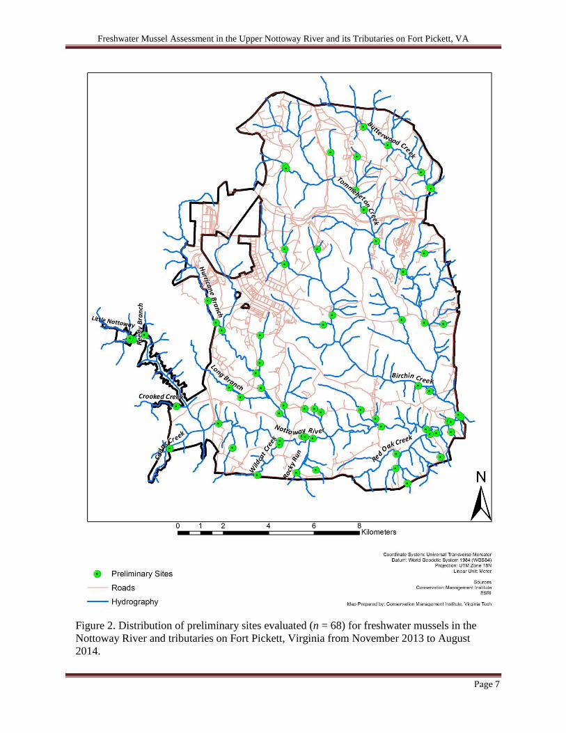
tributary was dependent on tributary size (i.e., length). In total, we selected 68 preliminary
reaches for evaluation: 7 sites in the main-stem of the Nottoway below the reservoir, 2 sites
above the reservoir, and 59 sites distributed throughout tributaries on Fort Pickett (Fig. 2).
Preliminary evaluations included visual assessment of habitat suitability (e.g.,
mesohabitat types, substrate composition, large woody debris, etc.) and visual and tactile
searches for the presence of freshwater mussels. GPS coordinates were taken to mark areas
evaluated and species encounters. In addition, we recorded the presence of fish, Campeloma
decisum Say (pointed campeloma), Corbicula fluminea O.F. Müller (Asiatic clam), and
individuals from the family Sphaeriidae Deshayes (fingernail clams).
These preliminary evaluations allowed us to allocate time-intensive and in-depth survey
effort to areas with high likelihood of mussel presence. We used information gathered from these
68 site evaluations to aid in the selection of 18 sites for more in-depth sampling. The criteria
used to select sites for further sampling included: 1) reaches where mussels (live or dead) were
observed during initial evaluations or previous surveys, 2) reaches consisting of suitable mussel
habitat, and 3) reaches that had not been previous surveyed above the reservoir or in tributaries.
Habitat Measurements
We delineated each comprehensive survey site (n = 18) in the field prior to sampling to
characterize the physical habitat and estimate effective sampling area. Wetted width was
measured at 6 equally spaced transects along the length of each reach and GPS coordinates were
taken at the downstream and upstream endpoints. Dependent on average wetted width and
Freshwater Mussel Assessment in the Upper Nottoway River and its Tributaries on Fort Pickett, VA
Page 7
Figure 2. Distribution of preliminary sites evaluated (n = 68) for freshwater mussels in the
Nottoway River and tributaries on Fort Pickett, Virginia from November 2013 to August
2014.

Freshwater Mussel Assessment in the Upper Nottoway River and its Tributaries on Fort Pickett, VA
Page 8
availability of suitable habitat, each sampling reach ranged from 50–500 m in length. We also
assessed stream depth, flow velocity, water temperature, substrate composition, embeddedness,
turbidity, sediment deposits, and composition of large woody debris and aquatic vegetation at
each site.
Comprehensive Sampling Design
To obtain site-specific estimates of species richness, relative abundances, and densities,
and effectively assess distributions across a large spatial scale, we implemented a two-phase
sampling design following the general methodology in Villella and Smith (2005). During the
first sampling phase, we conducted timed searches at each of the 18 sites to assess reach-specific
species richness and relative abundances. Substrate surfaces were systematically and thoroughly
searched (visual and tactile) for live individuals and shell material by snorkeling and using
aquascopes, beginning at the downstream boundary and moving upstream for approximately 1–2
person-hours. We identified and measured all individuals and returned them to the substrate.
Banks adjacent to the stream and exposed areas were searched for shell material. We pooled all
eastern elliptio and Carolina slabshell encountered under eastern elliptio “complex” for data
analysis because of the large variability in eastern elliptio shell morphology and taxonomic
uncertainty (Johnson 1970) and to maximize survey efficiency, reduce handling stress, and
minimize disturbance to dense elliptio beds. Data collected during these timed searches were
used to optimally allocate quadrat-based sampling in the second phase and stratified sites based
on the following criteria: 1) tributary or main-stem site, 2) catch per unit effort (CPUE), and 3)
species richness. We then randomly selected a subset of the first phase sites from each stratum
for second phase quadrat sampling.
We calculated the number of sampling units (0.25-m2 quadrat samples) required to
estimate population density (mean mussels/m2) for a given level of precision at each reach
following the methods found in Smith (2001) and Strayer and Smith (2003). For smaller survey
reaches (< 10 m wetted width), we sampled quadrats using a systematic sampling design because
mussels generally were normally distributed and it offered good spatial coverage. Because
mussel density tended to be greater along the stream banks (i.e., clustered) of larger reaches (≥
10 m wetted width), we sampled quadrats using a stratified random design so as to concentrate
sampling effort where mussels were densest and to gain precision in parameter estimates. We
divided larger reaches (≥ 10 m width) into two stratum, classifying areas within 3 m of stream
banks as high density, and areas > 3 m from the banks (middle of channel) as low density. We
calculated optimal allocation of quadrat sampling effort for each stratum using the methods
found in Strayer and Smith (2003).
We hand excavated quadrats to 15–30 cm below the substrate surface identifying all
mussels encountered to species, measuring for length, and documenting their position in the
substrate as being observed at the surface or below before returning individuals to their
collection point. We assumed that all individuals ≥ 1 year old had a 100% probability of
detection within a quadrat. In the absence of sieving substrates, individuals < 1 year were
difficult to detect during quadrat sampling and therefore were not included in abundance and
density estimations. We completed all field surveys between November 2013 and August 2014.
Freshwater Mussel Assessment in the Upper Nottoway River and its Tributaries on Fort Pickett, VA
Page 9
Data Analysis
We used timed search data from the first phase of sampling to estimate site-specific
species richness, relative abundances, and CPUE at each study site. Species richness was defined
as the number of different species encountered. Relative abundance was expressed as the number
of individuals of a particular species as a proportion of the total number of mussels encountered.
CPUE was calculated as the number of mussels encountered per person-hour search effort
(mussels/hour).
We used quadrat survey data from the second phase of sampling to measure site-specific
mussel abundances and densities. Calculations of abundances and associated variances followed
formulas for systematic and stratified random sampling designs found in Smith et al. (2001) and
Strayer and Smith (2003). We defined abundance as the number of mussels (>1 year old) in the
study area at the time of the survey. Density was defined as the total number of mussels > 1 year
old per m2 and was derived by dividing the abundance estimate by the effective sampling area.
We assessed data for normality and calculated 95% confidence intervals around abundance and
density estimates using SAS software (SAS Institute, Inc., Cary, North Carolina, version 9.2).
Results
Preliminary Searches
From the 68 preliminary sites evaluated, we eliminated 2 sites in the main-stem and 48
sites in the tributaries from consideration for further surveying because of unsuitable habitat
characteristics (e.g., wetland/marsh habitat, pond, intermittent streams, or no available habitat
such as favorable substrate, stable banks, optimal flow, or large woody debris) and lack of
evidence that mussels were present (i.e., shells or live individuals). The 18 sites selected for
comprehensive sampling include 5 sites in the main-stem of the Nottoway below the reservoir, 2
sites in the main-stem above the reservoir, and 11 sites throughout tributaries (Figs. 3a, 3b; Table
A1). We identified 7 species of mussels during preliminary evaluations: triangle floater, eastern
elliptio complex (eastern elliptio and Carolina slabshell), eastern floater, creeper, paper
pondshell, and notched rainbow (Table 1; Figs. A2, A3, A4, A5, A6, and A11). We found live
individuals and shells of all species with the exception of the triangle floater and notched
rainbow (no live individuals, 1 fresh dead shell each, and several relic shells). Eastern elliptio
complex, followed by the creeper, were the most commonly observed species.
First Phase Sampling: Timed Searches
We encountered a total of 9 live species collectively across the 18 sites during timed
searches (Table 1; Tables 2a, 2b; Appendix B). All 9 species were encountered in the mainstem
of the Nottoway River, but only 4 of these species were observed in tributary sites. We collected
a total of 1,988 individuals across timed searches, comprised > 98% by eastern elliptio complex
and followed distantly by creeper (0.45%; Table 2b). Catch per unit effort ranged from 0–630
mussels per hour and was greatest in tributary sites. Species richness per site ranged from 0–4
species (Table 2a) and was greater in sites located in the main-stem of the Nottoway River. We
found three Atlantic pigtoe at two main-stem sites (Sites NoR_04 and NoR_08) that were 38, 49,
Freshwater Mussel Assessment in the Upper Nottoway River and its Tributaries on Fort Pickett, VA
Page 10
and 67 mm in length and estimated to be approximately 8, 15, and 33 years old using predicted
age-at-length curves, respectively (Wolf 2012). Daily water temperatures during sampling
ranged from 18–30°C (Table A1).
Second Phase Sampling: Quadrat Sampling
From our 18 timed search sites, we selected 4 sites for quadrat sampling, including 3 sites
in the main-stem of the Nottoway River and 1 tributary site in Birchin Creek. We encountered a
total of 452 live individuals representing 4 species collectively in quadrat sampling across sites.
Greater than 99% of individuals were represented by eastern elliptio complex. We found no shell
material for additional species that we did not encounter live (Table 1, Table 4). Water
temperatures during sampling ranged from 25–31°C (Table A1).
Estimated abundances of mussels ranged from 0 to as high as 16,350 individuals, and
densities ranged from 0 to as high as 109/m2, among sites. Birchin Creek (Site BiC_02)
contained the highest density of mussels. Although eastern elliptio complex were collected
during timed searches, no individuals were collected inside of quadrats at sampling site NoR_02
above the reservoir. Overall, quadrat sampling revealed fewer species relative to time searches
across all sites (Table 2a, Table 3).

Freshwater Mussel Assessment in the Upper Nottoway River and its Tributaries on Fort Pickett, VA
Page 11
Figure 3a. Distribution of sites assessed by timed searches (circles) and quadrat sampling
(stars) in tributaries located in the northern portion of Fort Pickett, Virginia from May–August
2014. Timed searches were also conducted at all quadrat sampling sites.

Freshwater Mussel Assessment in the Upper Nottoway River and its Tributaries on Fort Pickett, VA
Page 12
Figure 3b. Distribution of sites assessed by timed searches (circles) and quadrat sampling (stars) in the main-stem of the
Nottoway River and its tributaries located in the southern portion of Fort Pickett, Virginia from May–August 2014. Timed
searches were also conducted at all quadrat sampling sites.
Freshwater Mussel Assessment in the Upper Nottoway River and its Tributaries on Fort Pickett, VA
Page 13
Table 1. Freshwater mussel species of interest in the Nottoway River and its tributaries on Fort Pickett, Virginia and species
encountered from November 2013 to August 2014 by survey methodology.
Survey Methodology
Common name Scientific name Status2
Preliminary
(qualitative)
Timed
(CPUE)
Quadrat
Sampling
Dwarfwedge mussel Alasmidonta heterodon FE, SE * * *
Triangle floater Alasmidonta undulata
Eastern elliptio Elliptio complanata1
Carolina slabshell Elliptio congarea1
Yellow lance Elliptio lanceolata SSC * * *
Atlantic pigtoe Fusconaia masoni SOC, ST
Eastern lampmussel Lampsilis radiata SSC
Eastern floater Pyganodon cataracta
Creeper Strophitus undulatus
Paper pondshell Utterbackia imbecillis
Notched rainbow Villosa constricta
*Species not encountered during 2014 survey 1Eastern elliptio and Carolina slabshell individuals were pooled under eastern elliptio complex for data
analysis 2 Federal and state listed species status; FE = federally endangered, SOC = federal species of concern, SE =
state endangered, ST = state threatened, SSC = state species of species concern
Freshwater Mussel Assessment in the Upper Nottoway River and its Tributaries on Fort Pickett, VA
Page 14
Table 2a. Timed search data (numbers of individuals per species per site) for sites in the Nottoway River and its tributaries on Fort
Pickett, Virginia in May–August 2014 organized in descending catch per unit effort (CPUE). Catch per unit effort is defined as the
number of species observed per one unit of search effort (one unit of effort = one person-hour).
Site
Eastern
elliptio
complex1
Creeper Eastern
floater
Paper
pondshell
Atlantic
pigtoe
Triangle
floater
Eastern
lampmussel
Notched
rainbow Total Effort CPUE
No.
species
BiC_02* 750 0 4 2 0 0 0 0 756 1.2 630 4
ToC_02 473 0 2 0 0 0 0 0 475 1.4 343 3
NoR_04* 199 4 0 1 2 0 0 (1 shell) 206 1.2 172 5
NoR_08* 181 2 0 0 1 0 0 1 185 1.1 168 5
NoR_01 133 3 0 0 0 0 0 0 109 1.0 109 3
NoR_09 108 0 0 1 0 0 0 0 136 1.7 80 3
NoR_03 42 0 0 1 0 1 1 0 45 2.0 23 5
ToC_13 37 0 0 0 0 0 0 0 37 2.1 18 2
NoR_07 24 0 0 0 0 1 0 0 25 1.7 15 3
LNR_01 4 0 0 0 0 0 0 0 4 0.8 5 1
ROR_03 4 0 0 0 0 0 0 0 3 1.0 3 1
HuB_07 3 0 0 0 0 0 0 0 4 1.8 2 1
NoR_02* 2 0 0 0 0 0 0 0 2 1.0 2 1
WiC_02 1 0 0 0 0 0 0 0 1 1.3 1 1
NNT_03 0 0 0 0 0 0 0 0 0 0.9 0 0
RoR_01 0 0 0 0 0 0 0 0 0 1.1 0 0
ToC_07 0 0 0 0 0 0 0 0 0 1.9 0 0
ToC_10 0 0 0 0 0 0 0 0 0 1.7 0 0
Total 1961 9 6 5 3 2 1 1 1988 24.96
9
*Site was also surveyed using quadrat sampling 1Eastern elliptio and Carolina slabshell individuals were pooled under eastern elliptio complex for data analysis

Freshwater Mussel Assessment in the Upper Nottoway River and its Tributaries on Fort Pickett, VA
Page 15
Table 2b. Relative abundances (%) for sites in the Nottoway River and its tributaries on Fort Pickett, Virginia estimated by timed
searches in May–August 2014.
Site
Eastern
elliptio
complex1
Creeper Eastern
floater
Paper
pondshell
Atlantic
pigtoe
Triangle
floater
Eastern
lampmussel
Notched
rainbow
BiC_02* 99.21 0.00 0.53 0.26 0.00 0.00 0.00 0.00
ToC_02 99.58 0.00 0.42 0.00 0.00 0.00 0.00 0.00
NoR_04* 96.60 1.94 0.00 0.49 0.97 0.00 0.00 0.00
NoR_08* 97.84 1.08 0.00 0.00 0.54 0.00 0.00 0.54
NoR_09 97.79 2.21 0.00 0.00 0.00 0.00 0.00 0.00
NoR_01 99.08 0.00 0.00 0.92 0.00 0.00 0.00 0.00
NoR_03 93.33 0.00 0.00 2.22 0.00 2.22 2.22 0.00
ToC_13 100.00 0.00 0.00 0.00 0.00 0.00 0.00 0.00
NoR_07 96.00 0.00 0.00 0.00 0.00 4.00 0.00 0.00
HuB_07 100.00 0.00 0.00 0.00 0.00 0.00 0.00 0.00
LNR_01 100.00 0.00 0.00 0.00 0.00 0.00 0.00 0.00
ROR_03 100.00 0.00 0.00 0.00 0.00 0.00 0.00 0.00
NoR_02* 100.00 0.00 0.00 0.00 0.00 0.00 0.00 0.00
WiC_02 100.00 0.00 0.00 0.00 0.00 0.00 0.00 0.00
NNT_03 0.00 0.00 0.00 0.00 0.00 0.00 0.00 0.00
RoR_01 0.00 0.00 0.00 0.00 0.00 0.00 0.00 0.00
ToC_07 0.00 0.00 0.00 0.00 0.00 0.00 0.00 0.00
ToC_10 0.00 0.00 0.00 0.00 0.00 0.00 0.00 0.00
Total 98.64 0.45 0.30 0.25 0.15 0.10 0.05 0.05
*Site was also surveyed using quadrat sampling 1Eastern elliptio and Carolina slabshell individuals were pooled under eastern elliptio complex for data analysis

Freshwater Mussel Assessment in the Upper Nottoway River and its Tributaries on Fort Pickett, VA
Page 16
Table 3. Collection data and estimated abundances and densities (mussels/m2) for freshwater mussel species in the Nottoway River
and its tributaries on Fort Pickett, Virginia in July–August 2014 by quadrat sampling. n = number of sampling units (0.25-m2
quadrats). The coefficient of variation (CV = SE/mean) is equivalent to the level of precision of the estimate.
95% C.I. 95% C.I.
Site Date
Quadrat
Methodology n Species
no.
obs. CV Abundance Lower Upper Density Lower Upper
BiC_02 7/4/14 Systematic 12 Eastern elliptio complex1 326 0.17 16,300 14,511 18,089 108.67 96.74 120.60
Eastern floater 1 1.00 50 19 81 0.33 0.12 0.54
Total 327 0.17 16,350 14,560 18,140 109.00 97.07 120.93
NoR_02 8/6/14 Stratified 51 N/A 0 N/A N/A N/A N/A N/A N/A N/A
NoR_04 8/8/14 Stratified 50 Eastern elliptio complex
1 106 0.15 1,631 1,554 1,708 1.73 1.71 1.75
NoR_08 8/7/14 Stratified 53 Eastern elliptio complex
1 18 0.30 617 554 680 0.12 0.11 0.13
Paper pondshell 1 1.00 34 23 46 0.007 0.005 0.009
Total 19 0.29 651 588 714 0.13 0.12 0.14
1Eastern elliptio and Carolina slabshell individuals were pooled under eastern elliptio complex for data analysis

Freshwater Mussel Assessment in the Upper Nottoway River and its Tributaries on Fort Pickett, VA
Page 17
Discussion
The objectives of this study were to determine current freshwater mussel distributions
and site-specific estimates of species richness, relative abundance, and density in tributaries and
the main-stem of the Nottoway River across Fort Pickett. We conducted preliminary evaluations
at many sites and a two-phase sampling design at a sub-set of sites on Fort Pickett which allowed
us to effectively assess population dynamics and distributions across a large spatial scale. By
expanding our search areas outside historically surveyed sites we identified distributions of
freshwater mussel species on Fort Pickett that are not limited to the main-stem of Nottoway
River and the lower-most reaches of its tributaries (i.e. higher-order streams). We found that
mussel distributions were patchy throughout their range and that species richness and densities
varied greatly among sites and across the installation. The densest mussel beds were observed in
higher reaches (lower-order streams) of the tributaries—nearly 8 RKM from the main-stem of
the Nottoway River—indicating that there are healthy local populations in the tributaries and that
these areas may serve as spatial refugia for populations of several species from the main-stem.
Although they contained the densest mussel beds encountered, sampling in tributary sites
revealed lower species richness than sites in the main-stem of the Nottoway River. Of the 9
species observed in the main-stem, only eastern elliptio, Carolina slabshell, eastern floater, and
paper pondshell were encountered in tributary sites. Consistent with past species observational
data from below Birchin Lake in 1999 (Roble, pers. comm.), we found eastern floater and paper
pondshell to occupy sites located below Birchin (BiC_02) and Tommeheton (ToC_02) Lakes,
although at significantly lower abundances relative to eastern elliptio and Carolina slabshell.
Eastern elliptio, eastern floater, and paper pondshell were also observed in higher reaches of
Butterwood Creek and Birchin Creek during preliminary site evaluations (Figs. 4a, 4b). Apart
from these headwater and medium stream reaches, no other tributary study sites evaluated in
higher-reaches contained mussels. Factors such as absence of species-specific host fish or
unfavorable habitat conditions (e.g., temperature, stream flow, substrate composition, pollution,
sedimentation) influence mussel distributions and are likely why we did not encounter mussels in
other tributary survey sites (Vaughn and Taylor 1999). However, lack of mussel species
encounters within reaches does not signify absence across all tributaries, but that none were
detected given the search effort and area. Further sampling in additional tributary sites may
reveal the presence of other species.
Sampling in the lower-most reaches of Hurricane Branch, Rocky Run, Tommeheton
Creek, and Wildcat Creek (Sites HuB_07, RoR_03, ToC_13, and WiC_02) revealed lower
species richness and densities compared to tributary sites with live mussels in higher-reaches
(Figs. 4a, 4b). Eastern elliptio and Carolina slabshell were the only species encountered within
these lower-most reaches. Historically, triangle floater, eastern elliptio, and Atlantic pigtoe
occupied the lower-most reaches Hurricane Branch (Fleming and van Alstine 1994, Seybold
1998), with the last live Atlantic pigtoe detected in 1998. Like Chazal and Derge (2001), we only
detected eastern elliptio within this reach and agree that this decline in diversity may be
attributed to reduced flows and increased sedimentation that characterize portions of this reach
below the Range Road culvert. In addition, during searches in fall 2013, we noted that the water
within this reach was noticeably distinguished by a blue-greyish tint; a discoloration that had not
been reported by previous visits and that may be indicative of other contributing water quality
issues (Fig. 5). Because Atlantic pigtoe prefers swift flows, free of sedimentation and other
Freshwater Mussel Assessment in the Upper Nottoway River and its Tributaries on Fort Pickett, VA
Page 18
Figure 4a. Distribution of species observations located in the northern portion on Fort Pickett,
Virginia from November 2013 to August 2014 collected during preliminary evaluations,
timed searches, and quadrat sampling.
cscarey
Sticky Note
Eastern elliptio found here, too

Freshwater Mussel Assessment in the Upper Nottoway River and its Tributaries on Fort Pickett, VA
Page 19
Figure 4b. Distribution of species observations located in the southern portion on Fort Pickett, Virginia from November 2013 to
August 2014 collected during preliminary evaluations, timed searches, and quadrat sampling.

Freshwater Mussel Assessment in the Upper Nottoway River and its Tributaries on Fort Pickett, VA
Page 20
pollutants (Bogan 2002), it was not surprising that we did not detect this species in this reach of
Hurricane Branch.
Similar to previous surveys (Wolf 2006, 2008), distributions of mussels within each
main-stem Nottoway River site were clumped with individuals aggregating in patches along
stable banks and areas with large woody debris. This observed patchiness can be attributed to
flow refuges and stable habitats offered to mussels by large woody debris running parallel to
banks and substrates characterized by clay and compacted sand (Strayer 1999, Wolf 2008).
Because the substrate in the main-stem of the Nottoway River is very dynamic, consisting mostly
of coarse sand that frequently redistributes, these flow refuges and stable substrates protect
mussels from displacement. Correspondingly, we encountered very few individuals in the middle
of reaches in the main-stem where substrates were much less stable.
Collectively, we encountered a total of 9 different species in the main-stem of the
Nottoway River. With the exception of dwarf wedgemussel and yellow lance, we encountered all
species of interest. As in the tributaries, eastern elliptio and Carolina slabshell (eastern elliptio
complex in data summaries) were the most abundant species encountered in the main-stem;
comprising 93–100% of all individuals observed within a site. Although encountered
considerably less frequently than eastern elliptio and Carolina slabshell, creeper was the third
most abundant species observed in the main-stem. Of the Nottoway River sites, sites located near
the Hurricane Branch confluence (NoR_04), Wildcat Creek confluence (NoR_03), and below
Longstreet Road ford (NoR_08) had the highest species richness observed during timed searches
Figure 5. View of Hurricane Branch approximately five meters upstream of its junction with
the main-stem of the Nottoway River. Bluish-gray discoloration of water observed across
approximate 650 meter reach of Hurricane Branch surveyed from the confluence with the
Nottoway River to Range Road crossing, in November 2013.
Freshwater Mussel Assessment in the Upper Nottoway River and its Tributaries on Fort Pickett, VA
Page 21
(5 species at each of the 3 sites). In combination with observations made during preliminary site
evaluations, Site NoR_03 had the greatest species richness (n = 8) (Fig. 4b). Similarly, Wolf
(2006) reported Site NoR_03 (then designated Site 23-1) to have the greatest number of species
among survey sites in 2006.
Historically, Atlantic pigtoe has consistently been documented in the main-stem of the
Nottoway on Fort Pickett during mussel assessments. Fleming and Van Alstine (1994), Seybold
(1998), and Chazal and Derge (2001) each documented small quantities of live Atlantic pigtoe
and shell material in a small number of sites (n = 4–8) throughout the main-stem. Wolf (2006,
2008, 2010) reported a few individuals (1–3 individuals) in 10 of 25 sites surveyed in 2006, in 1
of 3 sites surveyed in 2007, and in 1 site surveyed in 2009. No individuals were located during
2010 searches, and only two Atlantic pigtoe were encountered in 69 hours of search effort across
6 sites in 2012 (Wolf 2012). Despite the differences in sampling designs between these
assessments, it is evident that increased search efforts for Atlantic pigtoe on Fort Pickett are
finding fewer live individuals over time; reflecting that the population in much of the Nottoway
River has declined in recent years.
Of the 5 main-stem Nottoway River sites below the reservoir, we found Atlantic pigtoe in
only 2 sites. While we did not encounter Atlantic pigtoe within several sites where it had
previously been collected (Wolf 2006, 2008), we did document Atlantic pigtoe at a site
(NoR_08) where previous surveys had not. We also documented Atlantic pigtoe at the site near
the Hurricane Branch confluence (NoR_04) where it historically had been detected easily and
collected in higher numbers relative to other sites on Fort Pickett, but where recent efforts have
been unsuccessful (Wolf 2012, Wolf and Emrick 2011). This is the first collection of live
Atlantic pigtoe at this site since 2009, signifying that they have not disappeared. These results do
not signify that the population is increasing, but indicate that Atlantic pigtoe near Hurricane
Branch have persisted at very low densities so as to be nearly undetectable in recent years.
Over the past 8 years, the average size (length) and age of Atlantic pigtoe encountered on
Fort Pickett have been approximately 50.5 mm, equating to an approximate age of 15–16 years.
During our assessments, we documented a 38 mm Atlantic pigtoe estimated to be approximately
7–9 years old, indicating that some level of recruitment was successful in 2005–2007. We did
not detect any individuals that would indicate that recruitment has occurred recently (i.e., 2008–
2013).
Reaches sampled in the Nottoway River above the reservoir are situated around the Little
Nottoway River confluence and corresponded with sites where Atlantic pigtoe, yellow lance,
eastern elliptio, and notched rainbow have been previously collected (Fleming and Alstine 1994).
With the exception of eastern elliptio, and similar to observations made in 1999–2000 (Chazal
and Derge 2001), our search efforts did not reveal any of these species above the reservoir.
However, we collected paper pondshell; a species which had previously been undocumented in
the reach. Although we did not detect Atlantic pigtoe, yellow lance, or additional species above
the reservoir given our effort, they may occupy other sections. Spatially-extensive qualitative
surveys should be conducted—particularly in reaches upstream of the Little Nottoway River
confluence where the influence of the reservoir is less pronounced—to investigate whether
imperiled Atlantic pigtoe and yellow lance still occupy the Nottoway River above the reservoir
on Fort Pickett.

Freshwater Mussel Assessment in the Upper Nottoway River and its Tributaries on Fort Pickett, VA
Page 22
Unsurprisingly, eastern elliptio and Carolina slabshell were the most abundant species
encountered across survey sites. They also had the largest distribution across Fort Pickett and
frequently were the only species represented within a site. A common and abundant species
found throughout the Atlantic slope, adult eastern elliptio have been shown to be tolerant of
extremely low dissolved oxygen conditions—persisting under environmental conditions that
many other mussel species cannot tolerate (Lewis 1984 as cited in Galbraith et al. 2012).
Additionally, eastern elliptio are host fish generalists capable of using several fish species for
glochidia development; hence, increasing their chances of successful recruitment (Lellis et al.
2013). Survey sites with the densest eastern elliptio beds, located below Birchin (BiC_02) and
Tommeheton (ToC_02) Lakes, were characterized by sand substrates overlain with considerable
quantities of silt (Figure 6) and higher water temperatures that approached 31°C. These
conditions suggest dissolved oxygen concentrations may have been low during sampling.
Although these local populations may appear self-sustaining because of high densities, eastern
elliptio glochidia and juveniles are more sensitive to low oxygen conditions relative to their adult
form and may not successfully develop into adults under these conditions (Galbraith et al. 2012).
The smallest eastern elliptio we encountered during timed (ToC_02) and quadrat
(BiC_02) surveys were 51 and 54 mm, respectively. Sizes of eastern elliptio collected ranged
from 51-121 mm with over 80% of individuals greater than 90 mm, suggesting that these local
populations are composed of older age classes and possibly have little to no annual recruitment
occurring in recent years. Although availability for detection at the surface varies seasonally and
Figure 6. Photograph of silt covering eastern elliptio at Site BiC_02 located below
Birchin Lake on Fort Pickett, Virginia in July 2014.

Freshwater Mussel Assessment in the Upper Nottoway River and its Tributaries on Fort Pickett, VA
Page 23
with size (Amyot and Downing 1991), it is unlikely that we missed individuals in the 20–50 mm
size range if they were present given our sampling effort. If low to no recruitment is occurring,
populations are composed of older age classes and possibly have little to no annual recruitment
occurring in recent years. Although availability for detection at the surface varies seasonally and
with size (Amyot and Downing 1991), it is unlikely that we missed individuals in the 20–50 mm
size range if they were present given our sampling effort. If low to no recruitment is occurring,
these populations will be vulnerable to disappearing as adults reach maximum age. Because
survey time was limited for these sites due to their location in the Controlled Access Area, we
recommend further collection of demographic data, as well as water quality sampling, be
completed to accurately determine the long-term viability of these two local populations.
Several hypotheses may explain why adult eastern elliptio are in high densities below
Birchin and Tommeheton Lakes, relative to other survey sites, including:
1) The habitat below Birchin Lake appears to be a more stable (relative to habitat in the
Nottoway) with characteristics such as stable substrate (e.g., sand, clay, detritus, and
gravel that is more compact than many of the other survey sites), along with woody
debris, vegetation, and root mats along banks that create more hydrologically stable areas
and provide refuge during high flow events.
2) There is an abundance of potential host fish available at high densities. Eastern elliptio
have been shown to successfully parasitize several centrarchid species including bluegill
(many observed; Figure B8), largemouth bass, and crappie; all of which reside in Birchin
and Tommeheton Lakes and can disperse downstream into and occupy these sites.
3) The lakes are likely very productive systems; providing mussels with steady and
enhanced food resources through increased nutrient availability and quality.
4) Reduced levels of anthropogenic disturbance in the Controlled Access Area relative to
training areas.
These dense local populations are ecologically significant in their ability to filter large
portions of the water and supply nutrients to the water column through nutrient cycling. Dense
mussel beds have been documented as capable of filtering volumes that exceed daily stream
discharge, with estimates of daily filtration rates documented as high as 6–12 liters per individual
(Vaughn et al. 2008). To put into perspective, if we only consider the mussels estimated to
occupy the 150 m2 sampled area below Birchin Lake, collectively they could filter 100,000 to
nearly 200,000 liters of water a day. In conjunction with nutrient cycling, this filtering ability
means they are capable of bio-accumulating any water contaminants present; a useful indicator
of environmental stress (USEPA 2008).
As a biological indicator taxon, declines in mussel species diversity, abundance, and
distribution on Fort Pickett may indicate the presence of underlying water quality issues that can
degrade aquatic ecosystems in the larger Nottoway river watershed. Several factors that have
been documented as contributing to overall habitat degradation and mussel declines in general
include 1) sedimentation and nutrient pollution from point and nonpoint sources, 2) chemical
pollution from copper sulfate (if used in reservoirs or lakes) and hazardous waste, and 3)

Freshwater Mussel Assessment in the Upper Nottoway River and its Tributaries on Fort Pickett, VA
Page 24
impoundments. Sedimentation and channel modification reduce channel and bank stability,
increase water temperatures, and increase nutrient runoff. Pollution inputs can contaminate
sediments and create toxic environments for non-target species (Dodds 2002). Increases in water
depth and reduction in flows by impoundments (e.g., dams and culverts) reduce stream capability
to transport sediment load—increasing silt accumulation that can smother mussels and other
benthic organisms (Watters 1999).
Degraded habitats and impoundments negatively affect the vitality and growth rates of
mussels and indirectly influence the viability of local mussel populations by altering fish species
composition and abundance. Poor habitat quality can reduce the availability of species-specific
host fish required for reproduction; reducing the likelihood of successful glochidial attachment
and recruitment. Additionally, impoundments block host fish upstream passages; fragmenting
local populations and increasing their susceptibility to extirpation.
Management Recommendations
To protect and increase remaining mussel populations on Fort Pickett, management
efforts should focus on conserving and enhancing existing, as well as restoring, suitable mussel
habitat. Reduction of sedimentation through the establishment and maintenance of riparian buffer
zones and avoidance of stream channel modifications and alterations to native vegetation
proximate to streams can increase the quality and availability of healthy habitats. Restoration of
riparian buffer zones would help reduce the potential for pesticides, nitrogen, phosphorus, and
other pollutants from entering streams. Removal of large woody debris is not recommended as it
plays an important component in shaping stream hydraulics and morphology (Shields and
Smith1992; Fetherston et al. 1995) and provides habitat for mussels on Fort Pickett. Habitat
protections should not only be focused in the main-stem of the Nottoway River, but should
extend into the tributaries to offer spatial refugia for mussels and reduce overall vulnerability to
extirpation. Not only would these actions have positive implications for mussel fauna but would
have cascading positive effects on the overall aquatic ecosystem.
Even with habitat improvements, local mussel populations may still be susceptible to
extirpation as a result of reduced availability of species-specific host fish. Because mussel
populations are dependent on host fish availability for long-term viability, fish communities
should routinely be monitored to detect vulnerabilities to local mussel populations. Fish
assessments would also help predict species-specific mussel distributions so that mussel
monitoring efforts can more efficiently target and identify mussel beds.
As one of the two remaining ‘viable’ Atlantic pigtoe populations in Virginia, the
declining encounters of Atlantic pigtoe on Fort Pickett are a cause for concern. Given the rate of
decline of Atlantic pigtoe throughout its range and its likelihood to be federally listed in the near
future, research to identify—and proactive management to minimize—threats to this state
threatened species, its habitat, and host fish on Fort Pickett are crucial to its conservation. We
recommended that this population of Atlantic pigtoe be routinely monitored, and suggest that
physiochemical water quality testing (e.g., dissolved oxygen, pH, temperature, nitrogen and
phosphorus concentrations, etc.) and host fish surveys be conducted in current and historically
occupied sites. An additional species to closely monitor alongside Atlantic pigtoe in future
studies is the eastern lampmussel, a state species of concern. Eastern lampmussel have

Freshwater Mussel Assessment in the Upper Nottoway River and its Tributaries on Fort Pickett, VA
Page 25
occasionally been encountered on Fort Pickett (1 in 2006, 2 in 2007, and 1 in this study), but
their distribution and status remain unknown. Because eastern lampmussel is a long-term
brooder, monitoring should be targeted in August–September when spawning occurs and
likelihood of detection is greater.
Understanding species dynamics in combination with the identification of specific factors
responsible for declines can provide resource managers with data required for developing
effective management plans. To accomplish these tasks, routine monitoring of freshwater mussel
and fish populations, physiochemical water quality, and physical habitats, are recommended as
they will provide a valuable measure of the health of freshwater mussels and the aquatic
ecosystem on Fort Pickett.

Freshwater Mussel Assessment in the Upper Nottoway River and its Tributaries on Fort Pickett, VA
Page 26
Acknowledgements
Funding for this project was provided by the Virginia Department of Military Affairs as a
part of the ongoing effort to protect and enhance natural resources on military lands while
supporting the training mission. We would like to thank Brian Watson from Virginia Department
of Game and Inland Fisheries for providing field assistance and valuable advice for this project.
We would also like to thank Maggie Pryatel from Virginia Tech and Ingrid Mans, Jesse Parker,
and Nick Kalen from The Conservation Management Institute at Virginia Tech for their field and
geospatial information systems assistance. Military lands are a finite commodity and
conservation of their natural resources is essential to the maintenance of the high quality training
environment required for the success of the training mission.
Freshwater Mussel Assessment in the Upper Nottoway River and its Tributaries on Fort Pickett, VA
Page 27
Literature Cited
Alderman, J.M. 2005. Mussel surveys for Catawba-wateree relicensing. Duke Power Company,
Charlotte, North Carolina. 319 pp.
Alderman, J.M., and J.D. Alderman. 2009. Chowan River freshwater mussel survey. Prepared
for Citizens Against OLF. Pittsboro, North Carolina. 56 pp.
Amyot, J.P., and J.A. Downing. 1991. Endo- and epibenthic distribution of the unionid mollusc
Elliptio complanata. Journal of the North American Benthological Society 10:280–285.
Bogan, A.E. 2002. Workbook and key to the freshwater bivalves of North Carolina. North
Carolina Freshwater Mussel Conservation Partnership, Raleigh. 101 pp.
Carey, C. S. 2013. An evaluation of population restoration and monitoring techniques for
freshwater mussels in the upper Clinch River, Virginia, and refinement of culture
methods for laboratory-propagated juveniles. Master’s thesis. Virginia Polytechnic 5
Institute and State University, Blacksburg.
Chazal, A.C., and K.L. Derge. 2001. Rare fauna inventory at Fort Pickett Maneuver Training
Center. Natural Heritage inventory. Natural Heritage Technical Report 01-12. Virginia
Department of Conservation and Recreation, Division of Natural Heritage, Richmond. 78
pp.
Dodds, W.K. 2002. Freshwater ecology: concepts and environmental applications. Academic
Press, San Diego, California.
Fetherston, K.L., R.J. Naiman, and R.E. Bilby. 1995. Large woody debris, physical process, and
riparian forest development in montane river networks of the Pacific Northwest.
Geomorphology 13:133–144.
Fleming, G.P., and N.E. van Alstine. 1994. Fort Pickett, Virginia, Natural Heritage inventory.
Natural Heritage Technical Report 94-3. Virginia Department of Conservation and
Recreation, Division of Natural Heritage, Richmond. 296 pp.
Galbraith, H.S., C.J. Blakeslee, and W.A. Lellis. 2012. Recent thermal history influences thermal
tolerances in freshwater mussel species (Bivalvia: Unionoida). Freshwater Science
31:83–92.
Haag, W.R. 2012. North American Freshwater Mussels: Natural History, Ecology, and
Conservation. Cambridge University Press, New York. 505 pp.
Haag, W.R., and J.D. Williams. 2014. Biodiversity on the brink: an assessment of conservation
strategies for North American freshwater mussels. Hydrobiologia 735:45–60.
Johnson, R.I. 1970. The systematics and zoogeography of the Unionidae (Mollusca: Bivalvia) of
the southern Atlantic Slope region. Bulletin of the Museum of Comparative Zoology
140:263–449.

Freshwater Mussel Assessment in the Upper Nottoway River and its Tributaries on Fort Pickett, VA
Page 28
Lellis, W.A., B.S. White, and J.L. Devers. 2013. Newly documented host fishes for the eastern
elliptio mussel Elliptio complanata. Journal of Fish and Wildlife Management 4:75–85.
Lewis, J.B. 1984. Comparative respiration in two species of freshwater unionid mussels
(Bivalvia). Malacological Review 17:101–102.
Neves, R.J., A.E. Bogan, J.D. Williams, S.A. Ahlstedt, and P.W. Hartfield. 1997. Status of
aquatic mollusks in the southeastern United States: a downward spiral of diversity. Pages
43–85 in G.W. Benz and D.E. Collins, eds. Aquatic fauna in peril: the Southeastern
perspective. Southeast Aquatic Research Institute, Lenz Design and Communications,
Special publication 1, Decatur, Georgia.
Ricciardi, A., and J.B. Rasmussen. 1999. Extinction rates of North American Freshwater fauna.
Conservation Biology 13:1220–1222
Seybold, W. 1998. Nottoway River survey for threatened and endangered mussels and fish on
Fort Pickett. Final Report. Conservation Assistance Program Tracking Number 0797-003.
Shields, D.F., and R.H. Smith. Effects of large woody debris removal on physical characteristics
of a sand-bed river. Aquatic Conservation: Marine and Freshwater Ecosystems 2:145–
163.
Smith, D.R., R.F. Villella, and D.P. Lemarié. 2001. Survey protocol for assessment of
endangered freshwater mussels in the Alleghany River, Pennsylvania. Journal of the
North American Benthological Society 20:118–132.
Strayer, D.L. 1999. Use of flow refuges by unionid mussels in rivers. Journal of the North
American Benthological Society 18:468–476.
Strayer, D.L., and D.R. Smith. 2003. A Guide to Sampling Freshwater Mussel Populations.
American Fisheries Society, Monograph 8, Bethesda, Maryland.
The Conservation Management Institute. 2007. Integrated natural resources management plan
and environmental assessment (INRMP): Fort Pickett Maneuver Training Center. The
Conservation Management Institute-Military Lands Division, Virginia Polytechnic
Institute and University, Blacksburg.
US Congress. 1973. Endangered Species Act of 1973. Public Law 93–205, 87 Stat. 884.
USEPA (United States Environmental Protection Agency). 2008. An introduction to freshwater
mussels as biological indicators including accounts of Interior Basin, Cumberlandian, and
Atlantic Slope species. Office of Environmental Information, Office of Information
Analysis and Access, Washington, D.C.
Vaughn, C.C., and C.M. Taylor. 1999. Impoundments and the decline of freshwater mussels: a
case study of an extinction gradient. Conservation Biology 13:912–920.
Vaughn, C.C., S.J. Nichols, and D.E. Spooner. 2008. Community and foodweb ecology of
Freshwater Mussel Assessment in the Upper Nottoway River and its Tributaries on Fort Pickett, VA
Page 29
freshwater mussels. Journal of the North American Benthological Society 27:409–423.
Villella, R.F., and D.R. Smith. 2005. Two-phase sampling to estimate river-wide populations of
freshwater mussels. Journal of the North American Benthological Society 24:357–368.
Watters, G.T. 1999. Freshwater mussels and water quality: a review of the effects of hydrologic
and instream habitat alterations. Pages 261–274 in: R.A. Tankersley, , D.I. Warmolts,
G.T. Watters, B.J. Armitage, P.D. Johnson, and R.S. Butler, eds. Freshwater Mollusk
Symposia Proceedings. Ohio Biological Survey, Columbus.
Williams, J.D., M.L. Warren, Jr., K.S. Cummings, J.L. Harris, and R.J. Neves. 1993.
Conservation status of freshwater mussels of the United States and Canada. Fisheries
18:6–22.
Wolf, E. D. 2005. Endangered species management plan for the Roanoke logperch (Percina rex)
at Army National Guard Maneuver Training Center Fort Pickett, Virginia. R-29.
Conservation Management Institute-Military Lands Division, Virginia Polytechnic
Institute and State University, Blacksburg. 71 pp.
Wolf, E.D. 2006. Freshwater mussel surveys of the Nottoway River at Fort Pickett, Nottoway
County, Virginia. R-51. Conservation Management Institute-Military Lands Division,
Virginia Polytechnic Institute and State University, Blacksburg. 12 pp.
Wolf, E.D. 2008. 2007 Atlantic pigtoe mussel survey of the Nottoway River at Military Training
Center Fort Pickett. R-65 20080331. Conservation Management Institute-Military Lands
Division, Virginia Polytechnic Institute and State University, Blacksburg. 36 pp.
Wolf, E.D. 2010. Propagation of species at risk Atlantic pigtoe on military installations.
Conservation Management Institute-Military Lands Division, Virginia Polytechnic
Institute and State University, Blacksburg. 43 pp.
Wolf, E.D. 2012. Propagation, culture, and recovery of species at risk Atlantic pigtoe. Project
number 11-108. Conservation Management Institute-Military Lands Division, Virginia
Polytechnic Institute and State University, Blacksburg. 54 pp.
Wolf, E.D., and V. Emrick. 2011. Propagation and culture of species at risk Atlantic pigtoe.
Project number 10-450. The Conservation Management Institute-Military Lands
Division, Virginia Polytechnic Institute and State University, Blacksburg. 37 pp.
Wolf, E.D. and M.B. Duncan. 2007. Fish health survey and biological assessment of the
Nottoway River for Fort Pickett Maneuver Training Center (FPMTC), Blackstone,
Virginia. Conservation Management Institute-Military Lands Division, Virginia
Polytechnic Institute and State University, Blacksburg. 40 pp.
Wolf, E.D. and V. Emrick. 2013. Watershed rapid biological assessment of Fort Pickett
Maneuver Training Center Conservation Management Institute-Military Lands Division,
Virginia Polytechnic Institute and State University, Blacksburg. 40 pp.
Freshwater Mussel Assessment in the Upper Nottoway River and its Tributaries on Fort Pickett, VA
Page 30
APPENDIX A
Stream conditions from 2014 freshwater mussel surveys on Fort Pickett, Virginia

Freshwater Mussel Assessment in the Upper Nottoway River and its Tributaries on Fort Pickett, VA
Page 31
Table A1. Site identification, date, stream conditions, and down- and upstream coordinates (UTM Zone 18, NAD 83) of timed search
and quadrat sampling sites in the upper Nottoway River and its tributaries on Fort Pickett, Virginia conducted in May–August 2014.
As an index of relative river depth and flow rate on the installation during sampling, we recorded daily mean discharge values (cubic
feet per second) for the Nottoway River as measured at U.S. Geological Survey gage number 02044500; located approximately 4.5
river kilometers downstream of the eastern boundary of Fort Pickett (i.e., these values are not survey-site specific).
Downstream Upstream
Reach
ID
Mainstem/
Tributary Stream Name Date
Water Temp
(°C)
Discharge
(cfs) x y x y
NoR_01 Mainstem Nottoway River 8/6/14 25 58 232775 4101592 232607 4101456
NoR_02 Mainstem Nottoway River 8/6/14 25 58 232711 4101616 232672 4101538
*8/6/14 25 58
NoR_03 Mainstem Nottoway River 6/10/14 23 103 239234 4097113 239184 4097116
NoR_04 Mainstem Nottoway River 8/8/14 27 45 240334 4097291 240361 4097235
*8/8/14 27 45
NoR_07 Mainstem Nottoway River 6/10/14 27 103 245666 4097634 245638 4097643
NoR_08 Mainstem Nottoway River 7/3/14 27 57 246761 4097951 246724 4097921
*8/7/14 26 42
NoR_09 Mainstem Nottoway River 8/7/14 27 54 243691 4097749 243636 4097743
BiC_02 Tributary Birchin Creek 7/2/14 29 60 241491 4102421 241534 4102690
*7/4/14 31 51
*Date and stream conditions during quadrat sampling
Freshwater Mussel Assessment in the Upper Nottoway River and its Tributaries on Fort Pickett, VA
Page 32
Table A1 (cont.):
Downstream Upstream
Reach
ID
Mainstem/
Tributary Stream Name Date
Water Temp
(°C)
Discharge
(cfs) x y x y
HuB_07 Tributary Hurricane Branch 6/11/14 26 101 240202 4097329 240083 4097451
LNR_01 Tributary Little Nottoway 8/6/2014 25 58 232623 4101602 232592 4101629
NNT_03 Tributary No-name Tributary 6/9/2014 21 106 237140 4096813 237000 4096627
RoR_01 Tributary Rocky Run 5/12/2014 20 198 240809 4095836 241096 4095641
ROR_03 Tributary Rocky Run 6/11/2014 22 101 240672 4097226 240522 4097146
ToC_02 Tributary Tommeheton Creek 7/4/2014 29 52 245594 4102311 245619 4102360
ToC_07 Tributary Tommeheton Creek 5/14/2014 20 165 242551 4108143 242711 4108515
ToC_10 Tributary Tommeheton Creek 5/13/2014 18 179
ToC_10A
239439 4109204 239297 4109263
ToC_10B
239496 4109100 239414 4109073
ToC_13 Tributary Tommeheton Creek 5/13/2014 22 179 247156 4098215 247035 4098328
WiC_02 Tributary Wildcat Creek 6/10/2014 22 103 239239 4097088 239151 4096929
*Date and stream conditions during quadrat sampling

Freshwater Mussel Assessment in the Upper Nottoway River and its Tributaries on Fort Pickett, VA
Page 33
APPENDIX B
Selected photographs from 2014 freshwater mussel survey on Fort Pickett, Virginia
Freshwater Mussel Assessment in the Upper Nottoway River and its Tributaries on Fort Pickett, VA
Page 34
Figure B-1. Atlantic pigtoe encountered (clockwise) at Sites NoR_08 (49 mm) and NoR_04 (67
and 38 mm) in the main-stem Nottoway River on Fort Pickett, Virginia, July 2014.
Freshwater Mussel Assessment in the Upper Nottoway River and its Tributaries on Fort Pickett, VA
Page 35
Figure B-2. Paper pondshell encountered at Site NoR_04 in the main-stem of the Nottoway River,
upstream of Hurricane Branch confluence, on Fort Pickett, Virginia in August 2014.
Figure B-3. Eastern floater encountered in Butterwood Creek during preliminary evaluations on
Fort Pickett, Virginia, in 2014.

Freshwater Mussel Assessment in the Upper Nottoway River and its Tributaries on Fort Pickett, VA
Page 36
Figure B-4. Triangle floaters encountered at Sites NoR_07 and NoR_03 in the main-
stem Nottoway River upstream of South Shacks Hole Road bridge crossing, and near
Wildcat Creek confluence (top to bottom), in June 2014.
Freshwater Mussel Assessment in the Upper Nottoway River and its Tributaries on Fort Pickett, VA
Page 37
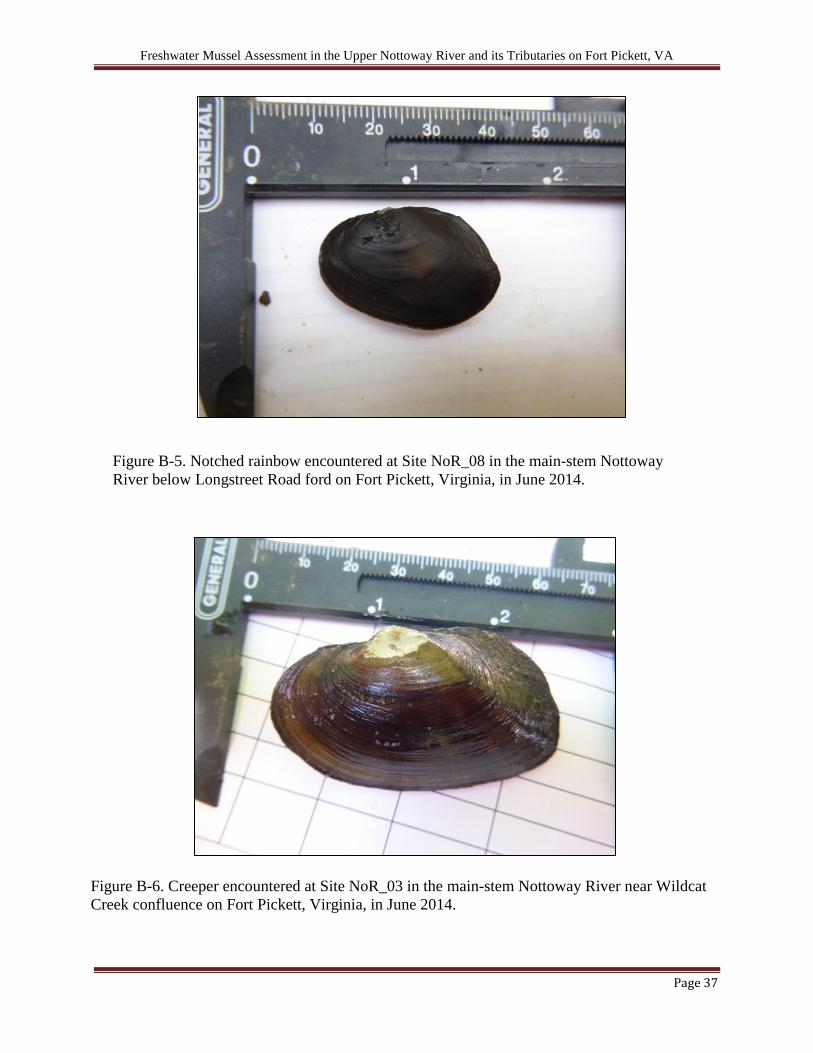
Figure B-5. Notched rainbow encountered at Site NoR_08 in the main-stem Nottoway
River below Longstreet Road ford on Fort Pickett, Virginia, in June 2014.
Figure B-6. Creeper encountered at Site NoR_03 in the main-stem Nottoway River near Wildcat
Creek confluence on Fort Pickett, Virginia, in June 2014.

Freshwater Mussel Assessment in the Upper Nottoway River and its Tributaries on Fort Pickett, VA
Page 38
Figure B-7. Eastern lampmussel observed at Site NoR_03 in the main-stem Nottoway River
near Wildcat Creek confluence on Fort Pickett, Virginia, in June 2014.
Figure B-8. Photograph of bluegill (Lepomis macrochirus) swimming by an eastern elliptio in
Birchin Creek below Birchin Lake on Fort Pickett, Virginia, in July 2014.

Freshwater Mussel Assessment in the Upper Nottoway River and its Tributaries on Fort Pickett, VA
Page 39
Figure B-9. Photograph of quadrat sampling at Site BiC_02 in Birchin Creek below
Birchin Lake. Substrate appearing black in image are hundreds of eastern elliptio.
Freshwater Mussel Assessment in the Upper Nottoway River and its Tributaries on Fort Pickett, VA
Page 40
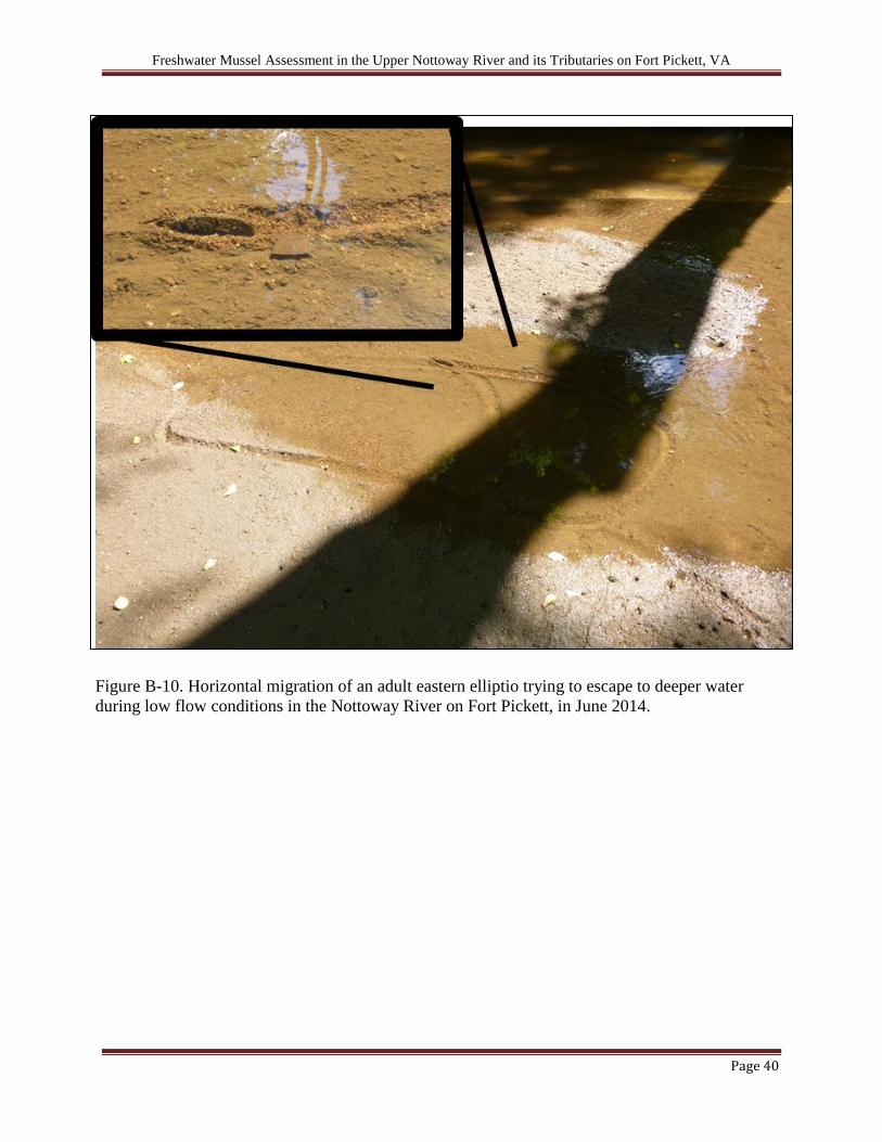
Figure B-10. Horizontal migration of an adult eastern elliptio trying to escape to deeper water
during low flow conditions in the Nottoway River on Fort Pickett, in June 2014.
Freshwater Mussel Assessment in the Upper Nottoway River and its Tributaries on Fort Pickett, VA
Page 41
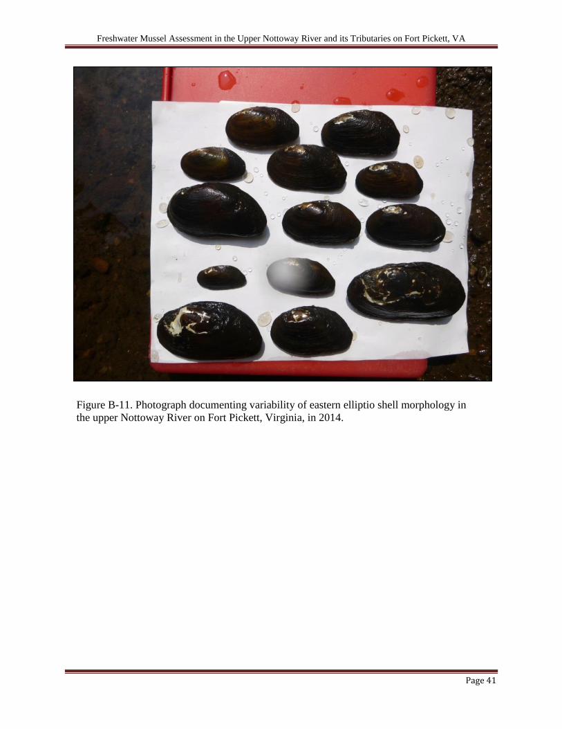
Figure B-11. Photograph documenting variability of eastern elliptio shell morphology in
the upper Nottoway River on Fort Pickett, Virginia, in 2014.