French technical guidelines for INSPIRE metadata for ... · French technical guidelines for INSPIRE...
68
French technical guidelines for INSPIRE metadata for spatial datasets Warning from the translator : this is a rough translation from a document established by the French national coordination structure. I am not Kenneth White 1 , and I have choosen to share fast this poor translation to allow the community to work with. Please feel free to correct it. Marc Leobet This document is under CC-BY licence. The original version is here : http://cnig.gouv.fr/wp- content/uploads/2014/01/Guide-de-saisie-des-éléments-de- métadonnées-INSPIRE-v1.1-final.pdf 1 See here http://www.kennethwhite.org/ and his "Latitudes & Longitudes" (thanks to Tim)
Transcript of French technical guidelines for INSPIRE metadata for ... · French technical guidelines for INSPIRE...
French technical guidelines for INSPIRE metadatafor spatial datasets
Warning from the translator : this is a rough translation from a document established by the French national coordination structure. I am not
Kenneth White1, and I have choosen to share fast this poor translation to allow the community to work with. Please feel free to correct it.
Marc Leobet
This document is under CC-BY licence.
The original version is here : http://cnig.gouv.fr/wp-content/uploads/2014/01/Guide-de-saisie-des-éléments-de-
métadonnées-INSPIRE-v1.1-final.pdf
1
See here http://www.kennethwhite.org/ and his "Latitudes & Longitudes" (thanks to Tim)

Working groupe "Metadata"Version 1.1 – December 2013
Thanks
The Metadata group is composed of members of the INSPIRE's Liaison Group and GeoSource Working Group. It was moderated by Marc Leobet. The Editor was Eliane Roos (IGN-F). The contributors were:
Hélène AUGU ONEMA
Olivier BANASZAK Ville du Havre
Valentin BLANLOT ISOGEO
Landry BREUIL CRAIG
Jean-Daniel CESARO ONEMA
Benjamin CHARTIER GeoPicardie
Chloé CHAUVEAU GIP ATGERI
Laurent COUDERCY ONEMA
Thomas GACHET SI17
Sylvain GRELLET Sandre OIEau
Chadi HAJJI MRN
Frédéric HOUBIE Geomatys
Clément JAQUEMET MEDDE/CGDD/DRI/MIG
Pierre LAGARDE BRGM
Marie LAMBOIS IGN
Marc LEOBET MEDDE/CGDD/DRI/MIG
Nicolas LESAGE IGN
Jean-Luc LIPATZ INSEE
Carole MICHAËL ONEMA
Arnaud MOLLE ERDF
Pierre NOUAILLE-DEGORCE IGN
Julien PAUGAM Région Bretagne
Claude PEYRARD Grand Lyon
Loîc REBOURSERDF
Maël REBOUX Rennes Métropole/Ville de Rennes
Yves RIALLANT AFIGEO
Elisabeth RINIÉ MEDDTE/CGEDD
Eliane ROOS IGN
Gilles ROUSSEAU ERDF
Etienne TAFFOUREAU BRGM
Fabrice THIEBAUX MEDDE/CERTU
Sandrine TOUS CRAIG
Roeland VAN DE VEN CG92
Loïc WATIER GIP ATGERI
Versions of the document
Edition Date Description
Projet 10 29.11.11 Implementation of the resolution of comments
Projet 11 06.12.11 Returns from LBT and PND
All recommendations to publishers are in Appendix C
Projet 12 13.12.11 Layout and adding Regulation metadata in Annex
Version 1 18.12.11 Publication
Version 1.1 prj1 16.09.13 Updated following users feedback, subject to public comment
Version 1.1 prj2 02.12.13 Resolution of comments
Version 1.1 20.12.13 Resolution of final comments and adding references to regulations and INSPIRE technical guidelines published in December 2013.
Table of Contents
I. INTRODUCTION.......................................................................................................................................... 6
I.1. OBJECTIVES.......................................................................................................................................................6I.2. GLOSSARY.........................................................................................................................................................6
II. DATA SET IDENTIFICATION......................................................................................................................... 8
II.1. RESOURCE TITLE................................................................................................................................................8II.2. RESOURCE ABSTRACT.........................................................................................................................................9II.3. RESOURCE TYPE..............................................................................................................................................10II.4. RESOURCE LOCATOR........................................................................................................................................11II.5. UNIQUE RESOURCE IDENTIFIER..........................................................................................................................12II.6. RESOURCE LANGUAGE......................................................................................................................................15II.7. ENCODING.....................................................................................................................................................16II.8. CHARACTER ENCODING....................................................................................................................................17
III. CLASSIFICATION OF SPATIAL DATA AND SERVICES...................................................................................18
III.1. TOPIC CATEGORY ...........................................................................................................................................18
IV. KEY WORDS............................................................................................................................................ 21
IV.1. REQUIRED KEYWORD: INSPIRE THEME ............................................................................................................22IV.2. RECOMMENDED KEYWORDS (OPTIONAL)............................................................................................................24IV.3. FREE KEYWORDS (OPTIONAL)...........................................................................................................................25
V. GEOGRAPHIC LOCATION.......................................................................................................................... 27
V.1. GEOGRAPHIC BOUNDING BOX...........................................................................................................................27V.2. COORDINATE REFERENCE SYSTEM......................................................................................................................28V.3. TEMPORAL REFERENCE.....................................................................................................................................30V.4. TEMPORAL EXTENT..........................................................................................................................................32V.5. REFERENCE DATES...........................................................................................................................................33
V.5.1. Date of publication..............................................................................................................................33V.5.2. Date of création..................................................................................................................................33V.5.3. Date of last revision............................................................................................................................34
V.6. TEMPORAL REFERENCE SYSTEM.........................................................................................................................35
VI. QUALITY ET VALIDITY.............................................................................................................................. 36
VI.1. LINEAGE.......................................................................................................................................................36VI.2. SPATIAL RESOLUTION......................................................................................................................................38VI.3. TOPOLOGICAL CONSISTENCY ...........................................................................................................................39VI.4. CONFORMITY................................................................................................................................................41VI.5. SPECIFICATIONS.............................................................................................................................................42VI.6. DEGREE OF CONFORMITY................................................................................................................................44
VII. CONSTRAINT RELATED TO ACCESS AND USE ..........................................................................................45
VII.1. GENERAL.....................................................................................................................................................45VII.2. CONDITIONS APPLYING TO ACCESS AND USE......................................................................................................50VII.3. EXAMPLES AND IMPLEMENTATION...................................................................................................................51
VII.3.1. The simplest case .............................................................................................................................51VII.3.2. Data under open licenses.................................................................................................................52VII.3.3. Data with fees...................................................................................................................................53VII.3.4. Data with other public access restriction.........................................................................................54VII.3.5. Adding use limitations ......................................................................................................................56VII.3.6. Data with security constraints..........................................................................................................57
VIII. ORGANISATION RESPONSIBLE FOR THE ESTABLISHMENT, MANAGEMENT, MAINTENANCE AND DISTRIBUTION OF SPATIAL DATA SETS AND SERVICES...................................................................................59
VIII.1. RESPONSIBLE PARTY ....................................................................................................................................59VIII.2. RESPONSIBLE PARTY ROLE .............................................................................................................................60
IX. METADATA ON METADATA..................................................................................................................... 62
IX.1. METADATA POINT OF CONTACT........................................................................................................................62IX.2. METADATA DATE...........................................................................................................................................63IX.3. METADATA LANGUAGE...................................................................................................................................63
I......................................................................................................Introduction
I.1. Objectives
This document establishes national guidelines regarding the INSPIRE Metadata for series and datasets. National recommendations regarding service metadata are provided in the "« Guide de saisie des métadonnées de service INSPIRE » CNIG (not translated).By implementing large-scale metadata capture, the INSPIRE Directive brought the cataloging activity out of a limited number of administators of spatial data and thus shows a need for explanations. This guide aims to respond to this need. It was established by a group of experts from various backgrounds, under the CNIG umbrella.Its perimeter is strictly restricted to INSPIRE's one, that is to say that this guide is intended to meet the obligations imposed by the regulation about metadata. For this, it reviews each field, providing the regulatory requirements, an educational comment, and national recommendations.Finally, this document is primarily intended for those who have to create metadata, whether data administrators or thematicians. Vocabulary would like to be as clear as possible, and examples illustrate the text as far as possible. More technical parts used to provide XML and XPath ISO 19115 for each element INSPIRE example. These parts will be removed to form a "light version".
This document is accompanied by the " « Guide de gestion des catalogues de métadonnées INSPIRE » dedicated to administrators catalog , specifying and detailing some useful concepts for the definition of the "political metadata" of an organization.
Annex C is a set of recommendations to be implemented by the tools for editing and viewing metadata. The Annex F defines the correspondence between the elements of INSPIRE Metadata and ISO 19115/19139 (metadata) standards.
I.2. Glossary
SPATIAL DATA SET
[INSPIRE] an identifiable collection of spatial data;. [National Recommendation] A set of geographical data distributed according to a dominant theme. Example: An orthoimagery of a region is a dataset. Urban planning documents in force on a well-defined period is a data set.
SPATIAL DATA SET SERIES
[INSPIRE] a collection of spatial data sets sharing the same product specification.
Exemple : A serie of orthoimagery on the same region through the time is a data set serie, as the successive urban planning documents of a place.
Cons-exemple : all the urban planning documents in a country are not a data set series if they do not share the same product specification.
Note : The « Guide de gestion des catalogues de métadonnées INSPIRE » of the CNIG specifies these notions of data set and data set series.
DATA SET MODEL (TEMPLATE)
Translation of a data model associated with rules (topology, quality). The interest is, for example, to allow a local transport authority to provide a data model to its carriers. Example: Templates MapInfo of a geostandard COVADIS (a national standard in France).
DATA
In this document, the term "data" is a generic term for both data set and data set series.
RESSOURCE
In this document, the term "resource" includes series set series and spatial data services.
CONFORMITY
State of two or more similar to each other things: conformity of two objects (Larousse’s dictionnary). The conformity of a data set to a specification means the full implementation of this specification. This conformity may have degrees in the case of partial implementation.
THESAURUS, ou dictionary of key words
Set of keywords organized in hierarchical and synonymously manner to classify or link resources.
METADATA
[INSPIRE] information describing spatial data sets and spatial data services and making it possible to discover, inventory and use them.
METADATA TEMPLATE
Standard record associated with a data set model. It defines the metadata elements to be filled. In standards, this is called "User view", a term which seems to be less obvious to understand. Example: the COVADIS templates contain metadata records.
REPEATABLE METADATA ELEMENT
This is a metadata element that can appear multiple times in a metadata record. Example: The point of contact for the resource is a repeatable element : it may be the man-ager of the corporate website and the service administrator of the data. Similarly, there may be multiple keywords. However, the metadata element "title of the resource" can not be re-peated.
VINTAGE A period of origin or manufacture, related to data updated regularly (for ex. Census)
VERSION Data updated irregularly (eg, with respect to a specification version)
II. Data set IdentificationAvailable IT tools are based on the ISO 19115 standard, which does not fully meet the requirements of the INSPIRE Directive. The recommendations are therefore intended to be both consistent with the directive and standard.
II.1. Resource title
INSPIRE REQUIREMENTS :
[INSPIRE] This a characteristic, and often unique, name by which the resource is known.
The value domain of this metadata element is free text.
It cannot be repeated
Comments
This means that the title should be precise enough to describe the data content. We must not forget that thousands of metadata from different organizations appear on the national Géocatalogue (and more generally at the European level). For example, it is recommended to specify the territory affected by the resource. Indeed, the title Local Development Plan (an urban planning document) alone will not allow the user to easily find the resource they want. Another example is found on the Géocatalogue metadata entitled “Useful Maps”. This title is not characteristic or unique and does not allow the user to understand what is the data. In addition, the responsible parties are already encoded in the "Responsible Party", there is no need to repeat the producer’s name in the title.
NATIONAL RECOMMENDATIONS :
1 . It is recommended to include an indication of the geographical area covered, especially if the same type of resource is available in several territories.2 . The use of a version or vintage indication is warranted where there are (or will be) several versions cohabiting in the catalog.3 . It is recommended not to include the responsible parties that is to say, organizations exer-cising any liability (manager, owner...) .4 . It is expected a significant text identifying the resource. Any empty text (whitespace) or “no information” text-like does not satisfy the INSPIRE’s obligation.5 . It is recommended not to specify only the acronym or abbreviation of the resource (unless it is explicited in the summary). Two approaches are recommended and are potentially com-plementary:a. The acronym or abbreviation may be indicated in parentheses in the title with a goal share it with users;b . The acronym or abbreviation can be expressed in the summary.
Exemples :
Flood map of Paris
Cons-examples :
Useful map ; 2009_Rescue_Service_Map.
Technical reference
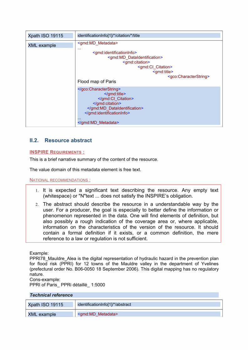
Xpath ISO 19115 identificationInfo[1]/*/citation/*/title
XML example <gmd:MD_Metadata>...
<gmd:identificationInfo><gmd:MD_DataIdentification>
<gmd:citation><gmd:CI_Citation>
<gmd:title><gco:CharacterString>
Flood map of Paris
</gco:CharacterString></gmd:title>
</gmd:CI_Citation></gmd:citation>
</gmd:MD_DataIdentification></gmd:identificationInfo>
...</gmd:MD_Metadata>
II.2. Resource abstract
INSPIRE REQUIREMENTS :
This is a brief narrative summary of the content of the resource.
The value domain of this metadata element is free text.
NATIONAL RECOMMENDATIONS :
1. It is expected a significant text describing the resource. Any empty text (whitespace) or "N"text ... does not satisfy the INSPIRE’s obligation.
2. The abstract should describe the resource in a understandable way by the user. For a producer, the goal is especially to better define the information or phenomenon represented in the data. One will find elements of definition, but also possibly a rough indication of the coverage area or, where applicable, information on the characteristics of the version of the resource. It should contain a formal definition if it exists, or a common definition, the mere reference to a law or regulation is not sufficient.
Example: PPRI78_Mauldre_Alea is the digital representation of hydraulic hazard in the prevention plan for flood risk (PPRI) for 12 towns of the Mauldre valley in the department of Yvelines (prefectural order No. B06-0050 18 September 2006). This digital mapping has no regulatory nature. Cons-example: PPRI of Paris_ PPRi détaillé_ 1:5000
Technical reference
Xpath ISO 19115 identificationInfo[1]/*/abstract
XML example <gmd:MD_Metadata>
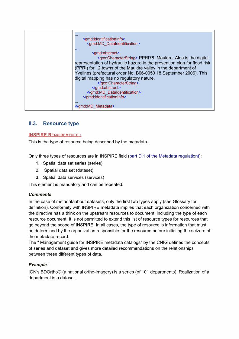
...<gmd:identificationInfo>
<gmd:MD_DataIdentification>…
<gmd:abstract><gco:CharacterString> PPRI78_Mauldre_Alea is the digital
representation of hydraulic hazard in the prevention plan for flood risk (PPRI) for 12 towns of the Mauldre valley in the department of Yvelines (prefectural order No. B06-0050 18 September 2006). This digital mapping has no regulatory nature.
</gco:CharacterString></gmd:abstract>
</gmd:MD_DataIdentification></gmd:identificationInfo>
...</gmd:MD_Metadata>
II.3. Resource type
INSPIRE REQUIREMENTS :
This is the type of resource being described by the metadata.
Only three types of resources are in INSPIRE field (part D.1 of the Metadata regulationt):
1. Spatial data set series (series)
2. Spatial data set (dataset)
3. Spatial data services (services)
This element is mandatory and can be repeated.
Comments
In the case of metadataabout datasets, only the first two types apply (see Glossary for definition). Conformity with INSPIRE metadata implies that each organization concerned with the directive has a think on the upstream resources to document, including the type of each resource document. It is not permitted to extend this list of resource types for resources that go beyond the scope of INSPIRE. In all cases, the type of resource is information that must be determined by the organization responsible for the resource before initiating the seizure of the metadata record. The " Management guide for INSPIRE metadata catalogs" by the CNIG defines the concepts of series and dataset and gives more detailed recommendations on the relationships between these different types of data.
Example :
IGN's BDOrtho® (a national ortho-imagery) is a series (of 101 departments). Realization of a department is a dataset.
Technical reference
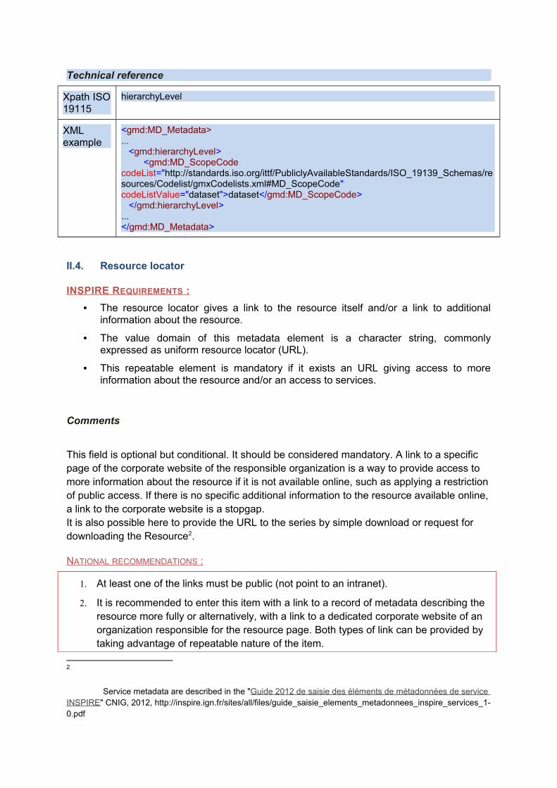
Xpath ISO 19115
hierarchyLevel
XML example
<gmd:MD_Metadata>...
<gmd:hierarchyLevel><gmd:MD_ScopeCode
codeList="http://standards.iso.org/ittf/PubliclyAvailableStandards/ISO_19139_Schemas/resources/Codelist/gmxCodelists.xml#MD_ScopeCode" codeListValue="dataset">dataset</gmd:MD_ScopeCode>
</gmd:hierarchyLevel>...</gmd:MD_Metadata>
II.4. Resource locator
INSPIRE REQUIREMENTS :
• The resource locator gives a link to the resource itself and/or a link to additional information about the resource.
• The value domain of this metadata element is a character string, commonly expressed as uniform resource locator (URL).
• This repeatable element is mandatory if it exists an URL giving access to more information about the resource and/or an access to services.
Comments
This field is optional but conditional. It should be considered mandatory. A link to a specific page of the corporate website of the responsible organization is a way to provide access to more information about the resource if it is not available online, such as applying a restriction of public access. If there is no specific additional information to the resource available online, a link to the corporate website is a stopgap. It is also possible here to provide the URL to the series by simple download or request for downloading the Resource2.
NATIONAL RECOMMENDATIONS :
1. At least one of the links must be public (not point to an intranet).
2. It is recommended to enter this item with a link to a record of metadata describing the resource more fully or alternatively, with a link to a dedicated corporate website of an organization responsible for the resource page. Both types of link can be provided by taking advantage of repeatable nature of the item.
2
Service metadata are described in the "Guide 2012 de saisie des éléments de métadonnées de service INSPIRE" CNIG, 2012, http://inspire.ign.fr/sites/all/files/guide_saisie_elements_metadonnees_inspire_services_1-0.pdf
3. The form of this information is preferably an URL.
Examples :
● http :// cartorisque . prim . net ./ dpt /75/75_ pprd . html ? xmin =594478& xmax =597339& ymin =2426728& ymax =2428636
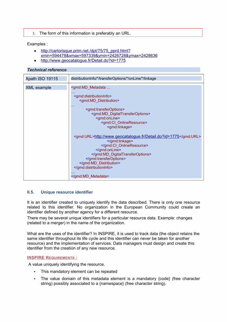
● http :// www . geocatalogue . fr / Detail . do ? id =1775
Technical reference
Xpath ISO 19115 distributionInfo/*/transferOptions/*/onLine/*/linkage
XML example <gmd:MD_Metadata ……
<gmd:distributionInfo><gmd:MD_Distribution>
…<gmd:transferOptions>
<gmd:MD_DigitalTransferOptions><gmd:onLine>
<gmd:CI_OnlineResource><gmd:linkage>
<gmd:URL>http :// www . geocatalogue . fr / Detail . do ? id =1775 </gmd:URL></gmd:linkage>
</gmd:CI_OnlineResource></gmd:onLine>
</gmd:MD_DigitalTransferOptions></gmd:transferOptions>
</gmd:MD_Distribution></gmd:distributionInfo>
…</gmd:MD_Metadata>
II.5. Unique resource identifier
It is an identifier created to uniquely identify the data described. There is only one resource related to this identifier. No organization in the European Community could create an identifier defined by another agency for a different resource.
There may be several unique identifiers for a particular resource data. Example: changes (related to a merger) in the name of the organization.
What are the uses of the identifier? In INSPIRE, it is used to track data (the object retains the same identifier throughout its life cycle and this identifier can never be taken for another resource) and the implementation of services. Data managers must design and create this identifier from the creation of any new resource.
INSPIRE REQUIREMENTS :
A value uniquely identifying the resource.
• This mandatory element can be repeated
• The value domain of this metadata element is a mandatory {code} (free character string) possibly associated to a {namespace} (free character string).
Comments
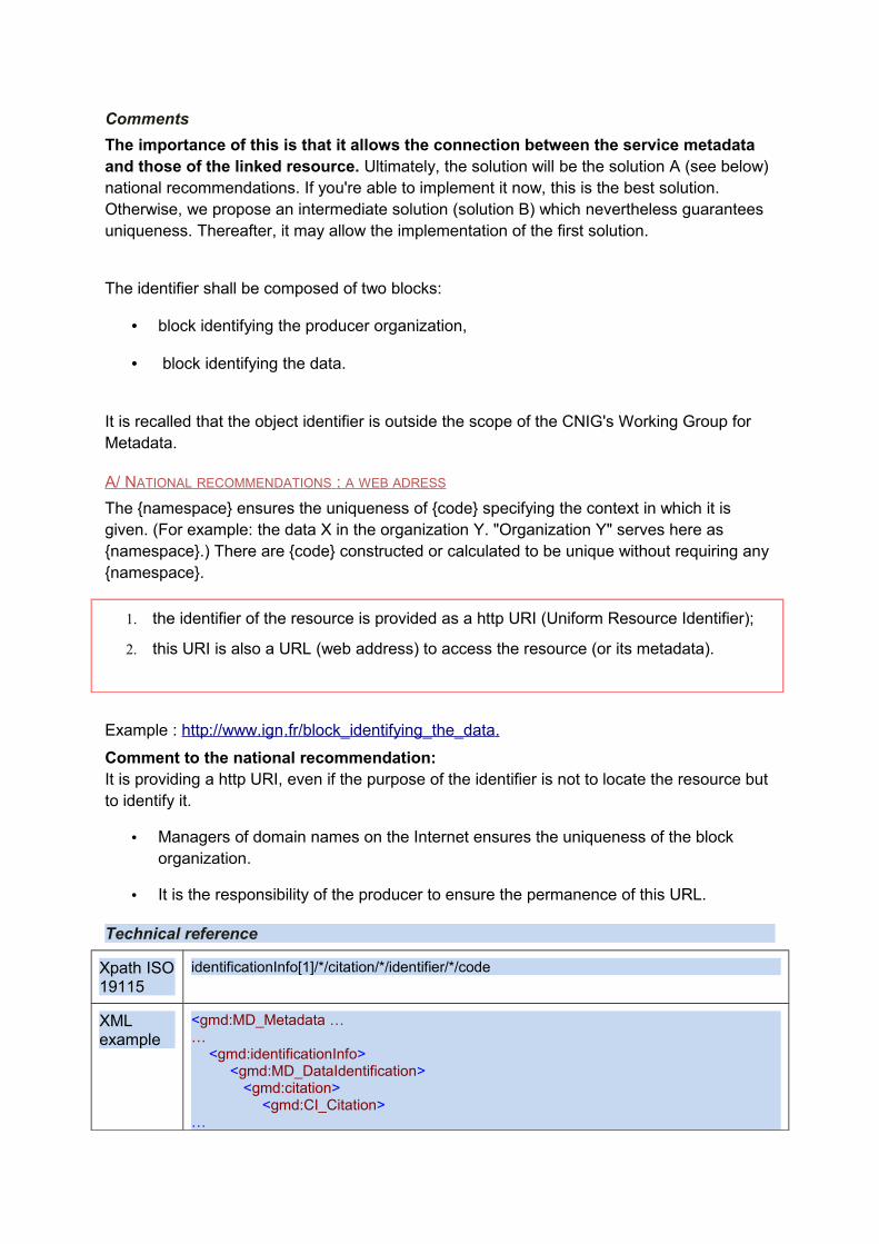
The importance of this is that it allows the connection between the service metadata and those of the linked resource. Ultimately, the solution will be the solution A (see below) national recommendations. If you're able to implement it now, this is the best solution. Otherwise, we propose an intermediate solution (solution B) which nevertheless guarantees uniqueness. Thereafter, it may allow the implementation of the first solution.
The identifier shall be composed of two blocks:
• block identifying the producer organization,
• block identifying the data.
It is recalled that the object identifier is outside the scope of the CNIG's Working Group for Metadata.
A/ NATIONAL RECOMMENDATIONS : A WEB ADRESS
The {namespace} ensures the uniqueness of {code} specifying the context in which it is given. (For example: the data X in the organization Y. "Organization Y" serves here as {namespace}.) There are {code} constructed or calculated to be unique without requiring any {namespace}.
1. the identifier of the resource is provided as a http URI (Uniform Resource Identifier);
2. this URI is also a URL (web address) to access the resource (or its metadata).
Example : http://www.ign . fr / block_identifying_the_data .
Comment to the national recommendation: It is providing a http URI, even if the purpose of the identifier is not to locate the resource but to identify it.
• Managers of domain names on the Internet ensures the uniqueness of the block organization.
• It is the responsibility of the producer to ensure the permanence of this URL.
Technical reference
Xpath ISO 19115
identificationInfo[1]/*/citation/*/identifier/*/code
XML example
<gmd:MD_Metadata ……
<gmd:identificationInfo><gmd:MD_DataIdentification>
<gmd:citation><gmd:CI_Citation>
…
<gmd:identifier><gmd:RS_Identifier>
<gmd:code>
<gco:CharacterString>http://www.ign . fr / block_identifying_the_data </gco:CharacterString></gmd:code>
</gmd:RS_Identifier></gmd:identifier>
</gmd:CI_Citation></gmd:citation>
…</gmd:MD_DataIdentification>
</gmd:identificationInfo>…</gmd:MD_Metadata>
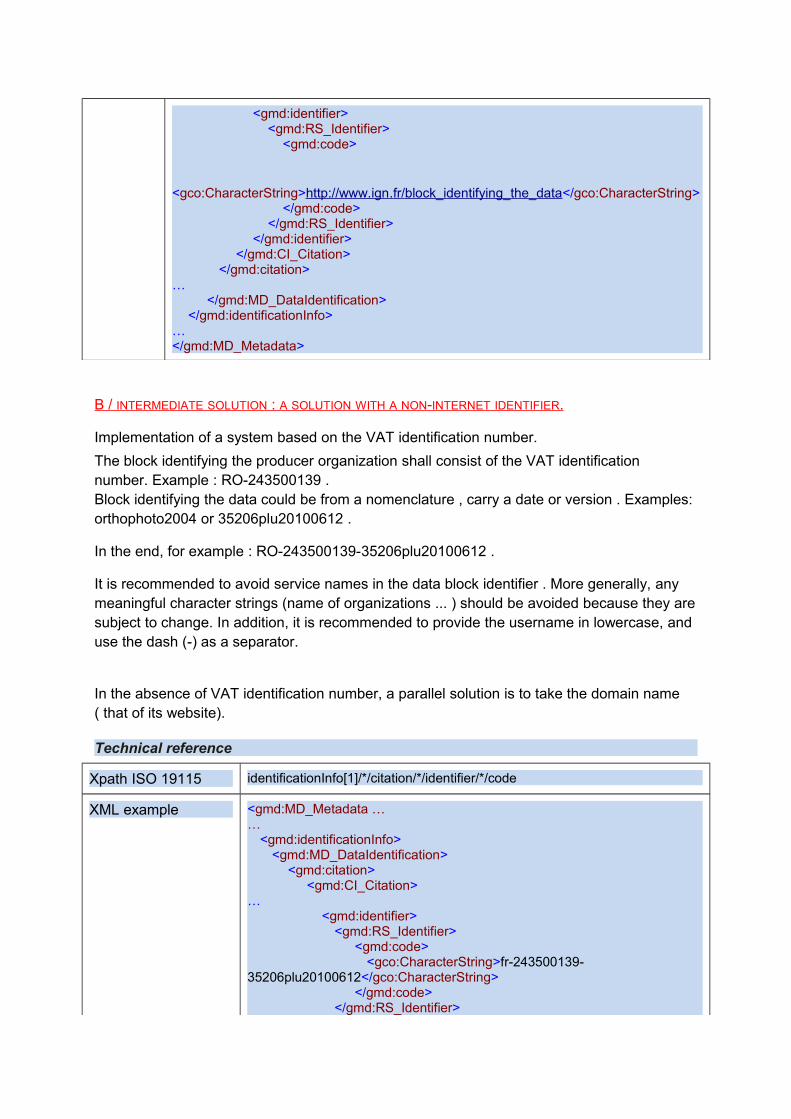
B / INTERMEDIATE SOLUTION : A SOLUTION WITH A NON-INTERNET IDENTIFIER.
Implementation of a system based on the VAT identification number.
The block identifying the producer organization shall consist of the VAT identification number. Example : RO-243500139 .Block identifying the data could be from a nomenclature , carry a date or version . Examples: orthophoto2004 or 35206plu20100612 .
In the end, for example : RO-243500139-35206plu20100612 .
It is recommended to avoid service names in the data block identifier . More generally, any meaningful character strings (name of organizations ... ) should be avoided because they are subject to change. In addition, it is recommended to provide the username in lowercase, and use the dash (-) as a separator.
In the absence of VAT identification number, a parallel solution is to take the domain name ( that of its website).
Technical reference
Xpath ISO 19115 identificationInfo[1]/*/citation/*/identifier/*/code
XML example <gmd:MD_Metadata ……
<gmd:identificationInfo><gmd:MD_DataIdentification>
<gmd:citation><gmd:CI_Citation>
…<gmd:identifier>
<gmd:RS_Identifier><gmd:code>
<gco:CharacterString>fr-243500139-35206plu20100612</gco:CharacterString>
</gmd:code></gmd:RS_Identifier>
</gmd:identifier></gmd:CI_Citation>
</gmd:citation>…
</gmd:MD_DataIdentification></gmd:identificationInfo>
…</gmd:MD_Metadata>
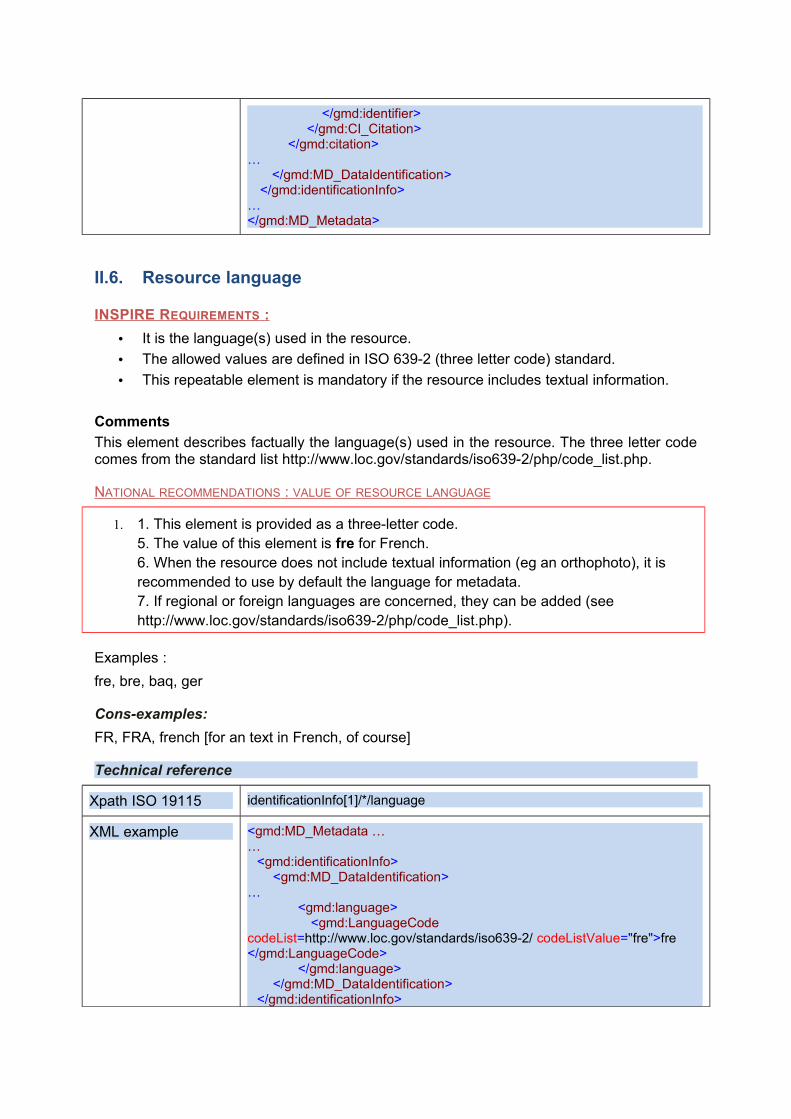
II.6. Resource language
INSPIRE REQUIREMENTS :
• It is the language(s) used in the resource.
• The allowed values are defined in ISO 639-2 (three letter code) standard.
• This repeatable element is mandatory if the resource includes textual information.
Comments
This element describes factually the language(s) used in the resource. The three letter code comes from the standard list http://www.loc.gov/standards/iso639-2/php/code_list.php.
NATIONAL RECOMMENDATIONS : VALUE OF RESOURCE LANGUAGE
1. 1. This element is provided as a three-letter code. 5. The value of this element is fre for French. 6. When the resource does not include textual information (eg an orthophoto), it is recommended to use by default the language for metadata.7. If regional or foreign languages are concerned, they can be added (see http://www.loc.gov/standards/iso639-2/php/code_list.php).
Examples :
fre, bre, baq, ger
Cons-examples:
FR, FRA, french [for an text in French, of course]
Technical reference
Xpath ISO 19115 identificationInfo[1]/*/language
XML example <gmd:MD_Metadata ……
<gmd:identificationInfo><gmd:MD_DataIdentification>
…<gmd:language>
<gmd:LanguageCode codeList=http://www.loc.gov/standards/iso639-2/ codeListValue="fre">fre </gmd:LanguageCode>
</gmd:language></gmd:MD_DataIdentification>
</gmd:identificationInfo>
…</gmd:MD_Metadata>
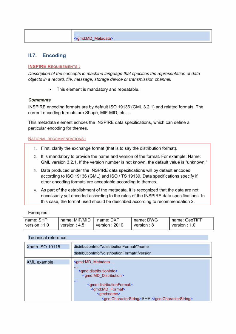
II.7. Encoding
INSPIRE REQUIREMENTS :
Description of the concepts in machine language that specifies the representation of data objects in a record, file, message, storage device or transmission channel.
• This element is mandatory and repeatable.
Comments
INSPIRE encoding formats are by default ISO 19136 (GML 3.2.1) and related formats. The current encoding formats are Shape, MIF-MID, etc ...
This metadata element echoes the INSPIRE data specifications, which can define a particular encoding for themes.
NATIONAL RECOMMENDATIONS :
1. First, clarify the exchange format (that is to say the distribution format).
2. It is mandatory to provide the name and version of the format. For example: Name: GML version 3.2.1. If the version number is not known, the default value is "unknown."
3. Data produced under the INSPIRE data specifications will by default encoded according to ISO 19136 (GML) and ISO / TS 19139. Data specifications specify if other encoding formats are acceptable according to themes.
4. As part of the establishment of the metadata, it is recognized that the data are not necessarily yet encoded according to the rules of the INSPIRE data specifications. In this case, the format used should be described according to recommendation 2.
Exemples :
name: SHPversion : 1.0
name: MIF/MIDversion : 4.5
name: DXFversion : 2010
name: DWGversion : 8
name: GeoTIFFversion : 1.0
Technical reference
Xpath ISO 19115 distributionInfo/*/distributionFormat/*/name
distributionInfo/*/distributionFormat/*/version
XML example <gmd:MD_Metadata ……
<gmd:distributionInfo><gmd:MD_Distribution>
…<gmd:distributionFormat>
<gmd:MD_Format><gmd:name>
<gco:CharacterString>SHP </gco:CharacterString>
</gmd:name><gmd:version>
<gco:CharacterString>1.0 </gco:CharacterString></gmd:version>
</gmd:MD_Format ></gmd:transferOptions>
</gmd:MD_Distribution></gmd:distributionInfo>
…</gmd:MD_Metadata>
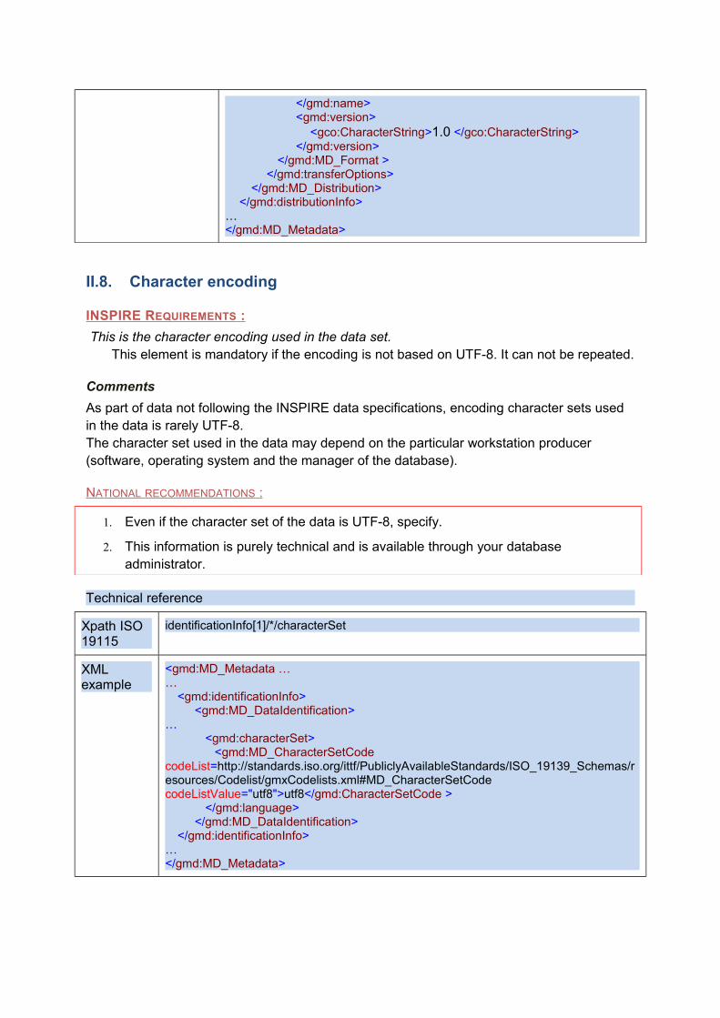
II.8. Character encoding
INSPIRE REQUIREMENTS :
This is the character encoding used in the data set. This element is mandatory if the encoding is not based on UTF-8. It can not be repeated.
Comments
As part of data not following the INSPIRE data specifications, encoding character sets used in the data is rarely UTF-8. The character set used in the data may depend on the particular workstation producer (software, operating system and the manager of the database).
NATIONAL RECOMMENDATIONS :
1. Even if the character set of the data is UTF-8, specify.
2. This information is purely technical and is available through your database administrator.
Technical reference
Xpath ISO 19115
identificationInfo[1]/*/characterSet
XML example
<gmd:MD_Metadata ……
<gmd:identificationInfo><gmd:MD_DataIdentification>
…<gmd:characterSet>
<gmd:MD_CharacterSetCode codeList=http://standards.iso.org/ittf/PubliclyAvailableStandards/ISO_19139_Schemas/resources/Codelist/gmxCodelists.xml#MD_CharacterSetCode codeListValue="utf8">utf8</gmd:CharacterSetCode >
</gmd:language></gmd:MD_DataIdentification>
</gmd:identificationInfo>…</gmd:MD_Metadata>
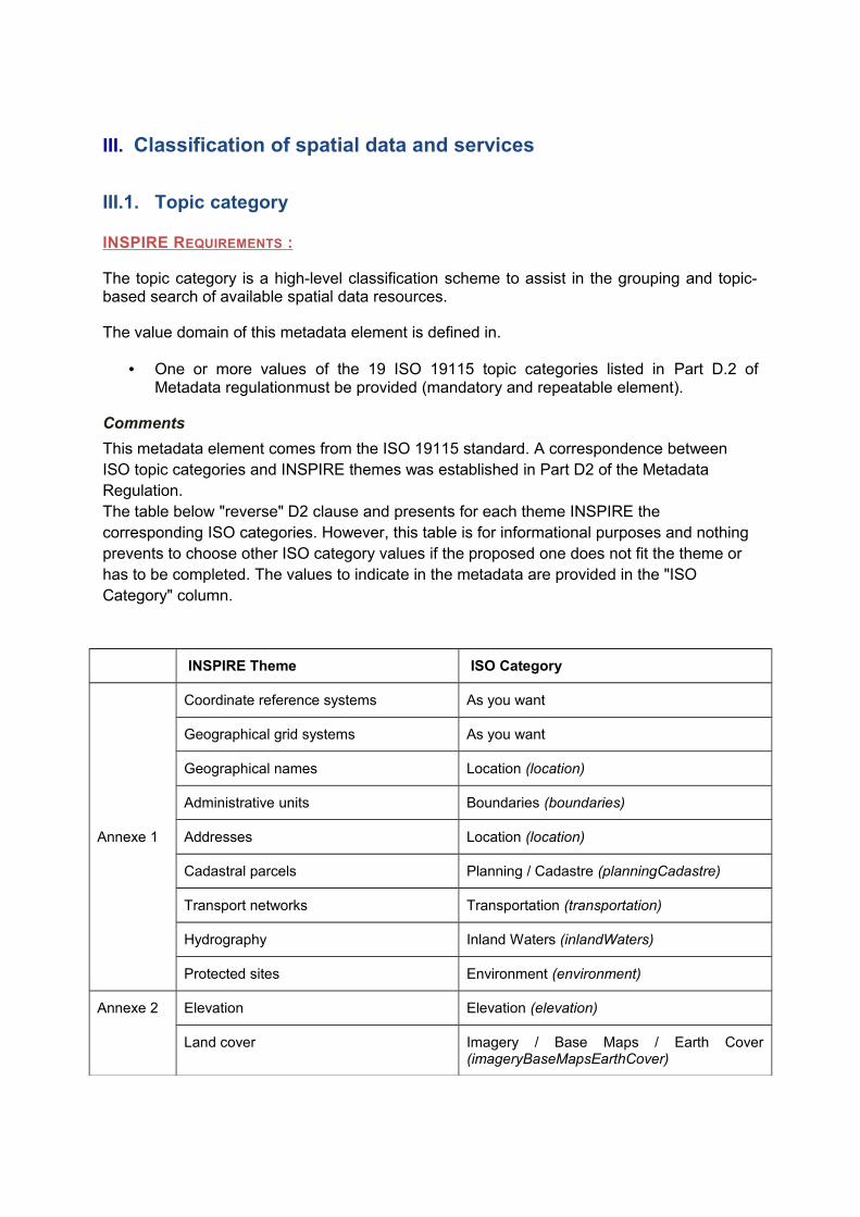
III. Classification of spatial data and services
III.1. Topic category
INSPIRE REQUIREMENTS :
The topic category is a high-level classification scheme to assist in the grouping and topic-based search of available spatial data resources.
The value domain of this metadata element is defined in.
• One or more values of the 19 ISO 19115 topic categories listed in Part D.2 of Metadata regulationmust be provided (mandatory and repeatable element).
Comments
This metadata element comes from the ISO 19115 standard. A correspondence between ISO topic categories and INSPIRE themes was established in Part D2 of the Metadata Regulation. The table below "reverse" D2 clause and presents for each theme INSPIRE the corresponding ISO categories. However, this table is for informational purposes and nothing prevents to choose other ISO category values if the proposed one does not fit the theme or has to be completed. The values to indicate in the metadata are provided in the "ISO Category" column.
INSPIRE Theme ISO Category
Annexe 1
Coordinate reference systems As you want
Geographical grid systems As you want
Geographical names Location (location)
Administrative units Boundaries (boundaries)
Addresses Location (location)
Cadastral parcels Planning / Cadastre (planningCadastre)
Transport networks Transportation (transportation)
Hydrography Inland Waters (inlandWaters)
Protected sites Environment (environment)
Annexe 2 Elevation Elevation (elevation)
Land cover Imagery / Base Maps / Earth Cover (imageryBaseMapsEarthCover)
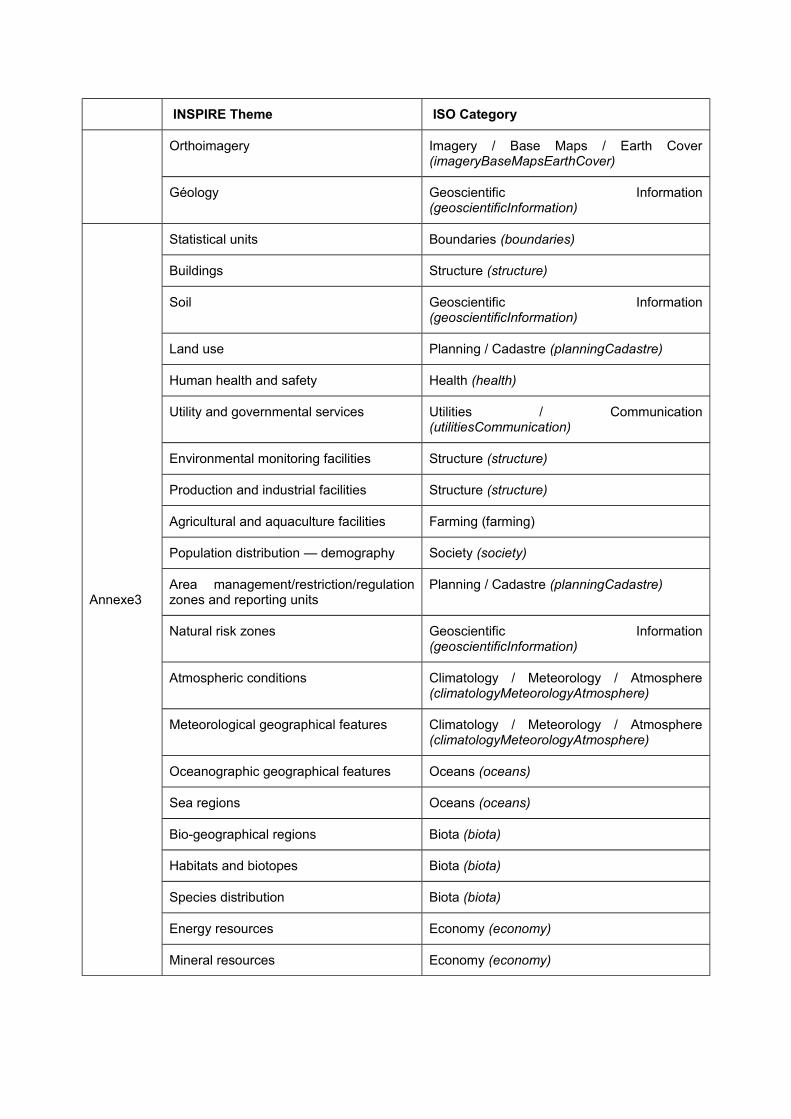
INSPIRE Theme ISO Category
Orthoimagery Imagery / Base Maps / Earth Cover (imageryBaseMapsEarthCover)
Géology Geoscientific Information (geoscientificInformation)
Annexe3
Statistical units Boundaries (boundaries)
Buildings Structure (structure)
Soil Geoscientific Information (geoscientificInformation)
Land use Planning / Cadastre (planningCadastre)
Human health and safety Health (health)
Utility and governmental services Utilities / Communication (utilitiesCommunication)
Environmental monitoring facilities Structure (structure)
Production and industrial facilities Structure (structure)
Agricultural and aquaculture facilities Farming (farming)
Population distribution — demography Society (society)
Area management/restriction/regulation zones and reporting units
Planning / Cadastre (planningCadastre)
Natural risk zones Geoscientific Information (geoscientificInformation)
Atmospheric conditions Climatology / Meteorology / Atmosphere (climatologyMeteorologyAtmosphere)
Meteorological geographical features Climatology / Meteorology / Atmosphere (climatologyMeteorologyAtmosphere)
Oceanographic geographical features Oceans (oceans)
Sea regions Oceans (oceans)
Bio-geographical regions Biota (biota)
Habitats and biotopes Biota (biota)
Species distribution Biota (biota)
Energy resources Economy (economy)
Mineral resources Economy (economy)
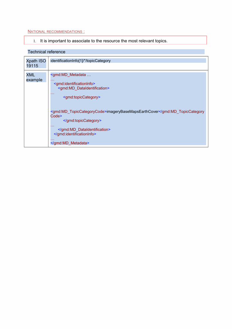
NATIONAL RECOMMENDATIONS :
1. It is important to associate to the resource the most relevant topics.
Technical reference
Xpath ISO 19115
identificationInfo[1]/*/topicCategory
XML example
<gmd:MD_Metadata ……
<gmd:identificationInfo><gmd:MD_DataIdentification>
…<gmd:topicCategory>
<gmd:MD_TopicCategoryCode>imageryBaseMapsEarthCover</gmd:MD_TopicCategoryCode>
</gmd:topicCategory>…
</gmd:MD_DataIdentification></gmd:identificationInfo>
…</gmd:MD_Metadata>
IV. Key words
INSPIRE REQUIREMENTS :
• If a resource is a spatial data set or spatial data set series, at least one keyword shall be provided from the general environmental multilingual thesaurus (GEMET) describing the relevant spatial data theme as defined in Annex I, II or III
• Keyword value : the keyword value is a commonly used word, formalised word or phrase used to describe the subject. While the topic category is too coarse for detailed queries, keywords help narrowing a full text search and they allow for structured keyword search.
• Originating controlled vocabulary : if the keyword value originates from a controlled vocabulary (thesaurus, ontology), for example GEMET, the citation of the originating controlled vocabulary shall be provided.
• Other keywords can be provided in addition. For more information, see the exact text of Regulation B2.3 part in the Annex.
Comments
In summary, it is requested a mandatory set of keywords : the INSPIRE theme(s); it is possible to provide additional words : one or more recommended key-words from validated thematic thesaurus or from thesaurus GEMET-Concepts, or one or more free key-words.
Validated thematic thesaurus allow to achieve better semantic interoperability, and are therefore more effective, but are rarely updated. Free keyword enable us to take into account the new objects (eg wind farm permits).
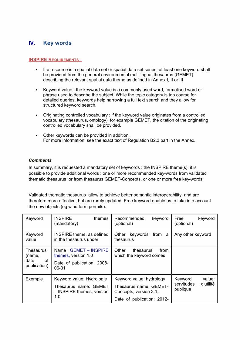
Keyword INSPIRE themes (mandatory)
Recommended keyword (optional)
Free keyword (optional)
Keyword value
INSPIRE theme, as defined in the thesaurus under
Other keywords from a thesaurus
Any other keyword
Thesaurus (name, date of publication)
Name : GEMET – INSPIRE themes, version 1.0
Date of publication: 2008-06-01
Other thesaurus from which the keyword comes
Exemple Keyword value: Hydrologie
Thesaurus name: GEMET – INSPIRE themes, version 1.0
Keyword value: hydrology
Thesaurus name: GEMET-Concepts, version 3.1,
Date of publication: 2012-
Keyword value: servitudes d'utilité publique
Date of publication: 2008-06-01
07-20
In the case of data included in the scope of the INSPIRE directive, the database administrator must necessarily inform the metadata element Keyword providing one keyword that value as the dominant theme of the INSPIRE data series and as Originating controlled vocabulary the thesaurus GEMET-INSPIRE themes. The values of the INSPIRE themes may be used if necessary for non INSPIRE data, provided they do not add the thesaurus "GEMET - INSPIRE themes, Version 1.0" of 2008-06-01. Finally, in all cases other keywords than INSPIRE themes may be indicated.
Example of a local plan: Required keyword: Zone Management etc.. Recommended keyword: "Urban Development Plan" (GEMET-Concepts, http://www.eionet.europa.eu/gemet/concept?cp=6285&langcode=fr&ns=1) or "planning and urban development "(http://www.eionet.europa.eu/gemet/concept?cp=11322&langcode=fr&ns=1) Free keyword: "public easement" and "SUP" (since the thesaurus offers neither this level of detail or synonyms).
Example of a Digital Cadastral Map Required keyword: Cadastral parcels. Recommended keyword: "building" (GEMET-Concepts, http://www.eionet.europa.eu/gemet/concept?cp=1029&langcode=fr&ns=1)
Cons-example for a local plan: development (http://www.eionet.europa.eu/gemet/concept?cp=8803&langcode=fr&ns=1)
Technical reference
Xpath ISO 19115 identificationInfo[1]/*/descriptiveKeywords/*/keyword
identificationInfo[1]/*/descriptiveKeywords/*/thesaurusName
XML example See examples in the following clauses
Note sur l’implémentation
When multiple keywords come from the same version of the thesaurus, they should be grouped in a single instance of the descriptiveKeywords property.
IV.1. Required keyword: INSPIRE theme
INSPIRE REQUIREMENTS :
• The thesaurus GEMET-INSPIRE themes is multilingual. The language in which the INSPIRE themes are expressed must be consistent with the language or metadata.
• This element is repeatable.
Comments
Data sets may correspond to several themes and the Regulation allows multiple attachments. However, conformity with INSPIRE specifications is established theme by theme (see Section VIII). This calls for a connection with a single theme.
In the case of data on several themes, we can provide multiple keywords corresponding to the additional themes on condition not to associate thesaurus GEMET-INSPIRE themes.
Be careful : that is the presence of the INSPIRE theme associated with the thesaurus GEMET-INSPIRE themes, which is taken into account to distinguish metadata within the scope of INSPIRE Directive and metadata describing resources outside the scope of INSPIRE. In this last case, it is essential not to inform the INSPIRE theme, so to do not use the thesaurus "GEMET - INSPIRE themes, Version 1.0" of 2008-06-01.
NATIONAL RECOMMENDATIONS :
1. It is recommended to attach a resource to only one INSPIRE theme.
2. INSPIRE does not explicitly identify the metadata element "INSPIRE theme" but its existence is induced by the demands made generally on the presence of keywords. The recommendation is to consider the INSPIRE theme as an metadata element at full part.
3. It is recommended not to provide this metadata element for resources that are not in the scope of INSPIRE (data about traffic accident, for example) being understood that for the resources in the field of INSPIRE, this element is mandatory.
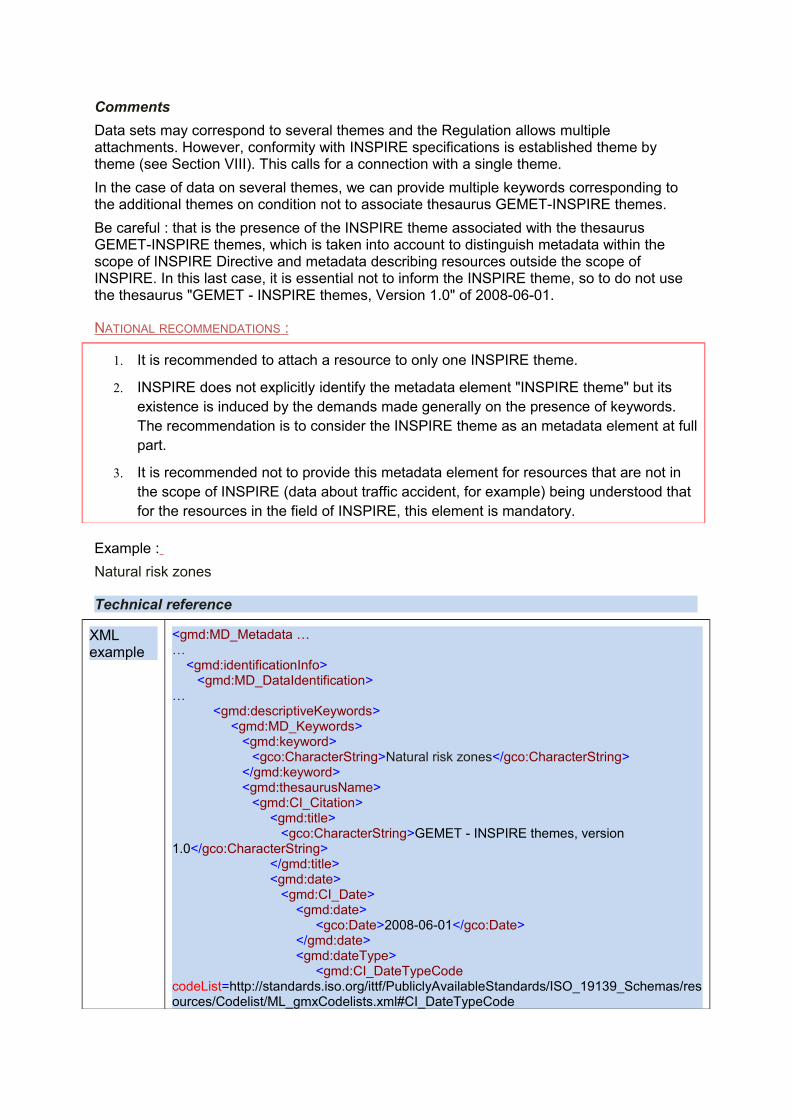
Example :
Natural risk zones
Technical reference
XML example
<gmd:MD_Metadata ……
<gmd:identificationInfo><gmd:MD_DataIdentification>
…<gmd:descriptiveKeywords>
<gmd:MD_Keywords><gmd:keyword>
<gco:CharacterString>Natural risk zones</gco:CharacterString></gmd:keyword><gmd:thesaurusName>
<gmd:CI_Citation><gmd:title>
<gco:CharacterString>GEMET - INSPIRE themes, version 1.0</gco:CharacterString>
</gmd:title><gmd:date>
<gmd:CI_Date><gmd:date>
<gco:Date>2008-06-01</gco:Date></gmd:date><gmd:dateType>
<gmd:CI_DateTypeCode codeList=http://standards.iso.org/ittf/PubliclyAvailableStandards/ISO_19139_Schemas/resources/Codelist/ML_gmxCodelists.xml#CI_DateTypeCode
codeListValue="publication">publication</gmd:CI_DateTypeCode></gmd:dateType>
</gmd:CI_Date></gmd:date>
</gmd:CI_Citation></gmd:thesaurusName>
</gmd:MD_Keywords></gmd:descriptiveKeywords>
</gmd:MD_DataIdentification></gmd:identificationInfo>
…</gmd:MD_Metadata>
Note about implementation
When multiple keywords from the same version of the thesaurus, they should be grouped in a single instance of the descriptiveKeywords property.
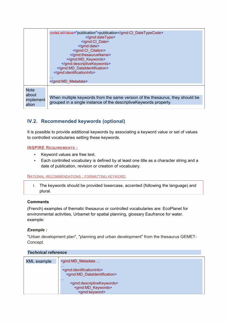
IV.2. Recommended keywords (optional)
It is possible to provide additional keywords by associating a keyword value or set of values to controlled vocabularies setting these keywords.
INSPIRE REQUIREMENTS :
• Keyword values are free text.
• Each controlled vocabulary is defined by at least one title as a character string and a date of publication, revision or creation of vocabulary.
NATIONAL RECOMMENDATIONS : FORMATTING KEYWORD
1. The keywords should be provided lowercase, accented (following the language) and plural.
Comments
(French) examples of thematic thesaurus or controlled vocabularies are: EcoPlanet for environmental activities, Urbamet for spatial planning, glossary Eaufrance for water. example:
Exemple :
"Urban development plan", "planning and urban development" from the thesaurus GEMET-Concept.
Technical reference
XML example <gmd:MD_Metadata ……<gmd:identificationInfo>
<gmd:MD_DataIdentification>…
<gmd:descriptiveKeywords><gmd:MD_Keywords>
<gmd:keyword>
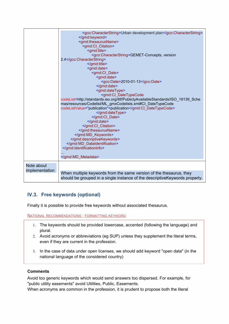
<gco:CharacterString>Urban development plan</gco:CharacterString></gmd:keyword><gmd:thesaurusName>
<gmd:CI_Citation><gmd:title>
<gco:CharacterString>GEMET-Concepts, version 2.4</gco:CharacterString>
</gmd:title><gmd:date>
<gmd:CI_Date><gmd:date>
<gco:Date>2010-01-13</gco:Date></gmd:date><gmd:dateType>
<gmd:CI_DateTypeCode codeList=http://standards.iso.org/ittf/PubliclyAvailableStandards/ISO_19139_Schemas/resources/Codelist/ML_gmxCodelists.xml#CI_DateTypeCode codeListValue="publication">publication</gmd:CI_DateTypeCode>
</gmd:dateType></gmd:CI_Date>
</gmd:date></gmd:CI_Citation>
</gmd:thesaurusName></gmd:MD_Keywords>
</gmd:descriptiveKeywords></gmd:MD_DataIdentification>
</gmd:identificationInfo>…</gmd:MD_Metadata>
Note about implementation
When multiple keywords from the same version of the thesaurus, they should be grouped in a single instance of the descriptiveKeywords property.
IV.3. Free keywords (optional)
Finally it is possible to provide free keywords without associated thesaurus.
NATIONAL RECOMMENDATIONS : FORMATTING KEYWORD
1. The keywords should be provided lowercase, accented (following the language) and plural.
2. Avoid acronyms or abbreviations (eg SUP) unless they supplement the literal terms, even if they are current in the profession.
3. In the case of data under open licenses, we should add keyword "open data" (in the national language of the considered country)
Comments
Avoid too generic keywords which would send answers too dispersed. For example, for "public utility easements" avoid Utilities, Public, Easements. When acronyms are common in the profession, it is prudent to propose both the literal

expression and the acronym, not knowing what will look the user. The information "open data" will be used for indexing by regional and national portals (eg data.gouv.fr), so it is important to keep the proposed case.
Example :
« open data »
« public utility easements » ; « PUE »
« Study and prevention of natural hazards »
Technical reference
XML example <gmd:MD_Metadata ……
<gmd:identificationInfo><gmd:MD_DataIdentification>
…<gmd:descriptiveKeywords>
<gmd:MD_Keywords><gmd:keyword>
<gco:CharacterString>public utility easements</gco:CharacterString>
</gmd:keyword></gmd:MD_Keywords>
</gmd:descriptiveKeywords></gmd:MD_DataIdentification>
</gmd:identificationInfo>…</gmd:MD_Metadata>
V. Geographic location
V.1. Geographic bounding box
INSPIRE REQUIREMENTS :
This is the extent of the resource in the geographic space, given as a bounding box.
The bounding box shall be expressed with westbound and eastbound longitudes, and southbound and northbound latitudes in decimal degrees, with a precision of at least two decimals.
The coordinates of the bounding rectangle are expressed in a geodetic reference coordinate defining the meridian of Greenwich as the prime meridian. This mandatory element is repeatable.
NATIONAL RECOMMENDATIONS :
1. The box should encompass the territory for which the producer guarantees the entry of the information provided, a part of the territory can be vacuum type provided (eg , in the case of Seveso sites location in Brittany, the bounding rectangle will hold all Brittany, although the bounding box for the Seveso sites is smaller: in fact, the absence of Seveso site is information itself on the rest of the Breton territory).
2. The bounding box must be adjusted as possible, in order to define as accurately as possible the described resource (do not give a rectangle covering the whole of France for data limited to a municipality).
3. If the resource covers metropolitan France and / or overseas territories , it will contain as many bounding boxes as geographical territories covered (no "global" box) . One box is defined for the case of a resource covering the metropolitan France.
4. If more than one boxes are given, they should not overlap
Comments:
Be careful, some IGN maps include two geographic coordinate systems based, one on the meridian of Paris, the other on the Greenwich meridian. Do not get the wrong system.
The order in which the coordinates are provided is not significant.
Example :
O : -4,24
S : 41,34
E : 10,81
N : 50,79
Technical reference
Xpath ISO 19115 identificationInfo[1]/*/extent/*/geographicElement
XML example <gmd:MD_Metadata ……
<gmd:identificationInfo><gmd:MD_DataIdentification>
…<gmd:extent>
<gmd:EX_Extent><gmd:geographicElement>
<gmd:EX_GeographicBoundingBox><gmd:westBoundLongitude>
<gco:Decimal>-4,24</gco:Decimal></gmd:westBoundLongitude><gmd:eastBoundLongitude>
<gco:Decimal>41,34</gco:Decimal></gmd:eastBoundLongitude><gmd:southBoundLatitude>
<gco:Decimal>10,81</gco:Decimal></gmd:southBoundLatitude><gmd:northBoundLatitude>
<gco:Decimal>50,79</gco:Decimal></gmd:northBoundLatitude>
</gmd:EX_GeographicBoundingBox></gmd:geographicElement>
</gmd:EX_Extent></gmd:extent>
…</gmd:MD_DataIdentification>
</gmd:identificationInfo>…</gmd:MD_Metadata>
V.2. Coordinate Reference System
INSPIRE REQUIREMENTS :
Description of the coordinate reference system(s) used in the data set.
• This mandatory element is repeatable
Comments :
The reference system is the one accessible by the user data. It is recommended to set a reference system available independent of any particular software.In the case of indirectly georeferenced data (statistics), we can not fulfill this reference system. This is the reference system associated geometric data that will populate this field.
NATIONAL RECOMMENDATIONS :
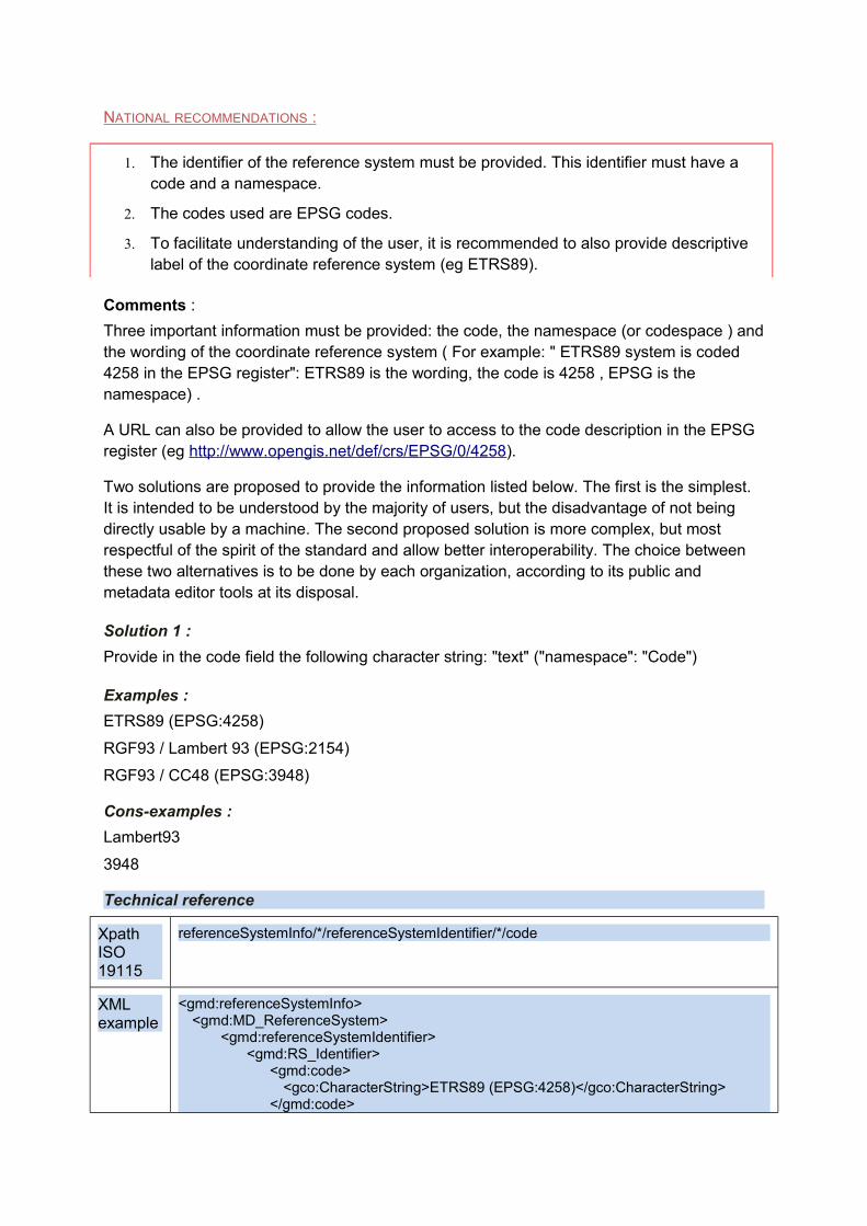
1. The identifier of the reference system must be provided. This identifier must have a code and a namespace.
2. The codes used are EPSG codes.
3. To facilitate understanding of the user, it is recommended to also provide descriptive label of the coordinate reference system (eg ETRS89).
Comments :
Three important information must be provided: the code, the namespace (or codespace ) and the wording of the coordinate reference system ( For example: " ETRS89 system is coded 4258 in the EPSG register": ETRS89 is the wording, the code is 4258 , EPSG is the namespace) .
A URL can also be provided to allow the user to access to the code description in the EPSG register (eg http://www.opengis.net/def/crs/EPSG/0/4258).
Two solutions are proposed to provide the information listed below. The first is the simplest. It is intended to be understood by the majority of users, but the disadvantage of not being directly usable by a machine. The second proposed solution is more complex, but most respectful of the spirit of the standard and allow better interoperability. The choice between these two alternatives is to be done by each organization, according to its public and metadata editor tools at its disposal.
Solution 1 :
Provide in the code field the following character string: "text" ("namespace": "Code")
Examples :
ETRS89 (EPSG:4258)
RGF93 / Lambert 93 (EPSG:2154)
RGF93 / CC48 (EPSG:3948)
Cons-examples :
Lambert93
3948
Technical reference
Xpath ISO 19115
referenceSystemInfo/*/referenceSystemIdentifier/*/code
XML example
<gmd:referenceSystemInfo><gmd:MD_ReferenceSystem>
<gmd:referenceSystemIdentifier> <gmd:RS_Identifier>
<gmd:code><gco:CharacterString>ETRS89 (EPSG:4258)</gco:CharacterString>
</gmd:code>

</gmd:RS_Identifier> </gmd:referenceSystemIdentifier>
</gmd:MD_ReferenceSystem></gmd:referenceSystemInfo>
Solution 2:
The code field is implemented as an Anchor element for storing the access URL to the coordinate system in the EPSG register (http://www.opengis.net/def/crs/EPSG/0/4258 ), a label in the xlink: title (ETRS89) and the code itself (4258). The namespace (EPSG) is provided in the codespace field.
Example :
URL : http :// www . opengis . net / def / crs / EPSG /0/4258
Text: ETRS89
Code : 4258
CodeSpace : EPSG
Technical reference
Xpath ISO 19115
referenceSystemInfo/*/referenceSystemIdentifier/*/code
referenceSystemInfo/*/referenceSystemIdentifier/*/codeSpace
XML example
<gmd:referenceSystemInfo><gmd:MD_ReferenceSystem>
<gmd:referenceSystemIdentifier> <gmd:RS_Identifier>
<gmd:code><gmx:Anchor
xlink:href="http://www.opengis.net/def/crs/EPSG/0/4258" xlink:title="ETRS89">4258</gmx:Anchor>
</gmd:code> <gmd:codeSpace>
<gco:CharacterString>EPSG</gco:CharacterString></gmd:codeSpace>
</gmd:RS_Identifier> </gmd:referenceSystemIdentifier>
</gmd:MD_ReferenceSystem></gmd:referenceSystemInfo>
V.3. Temporal reference
After a general paragraph explaining the INSPIRE requirements for the Temporal Reference field, this chapter details the metadata element Temporal extent (VI.1), then the reference dates (date of publication (VI.2.1) Date of creation (VI.2.2) and Date of last revision (VI.2.3)), and finally the temporal reference system (VI.3).
INSPIRE REQUIREMENTS :
• INSPIRE requires the provision of at least one temporal reference, which can be a date of creation, of last revision, of publication or a temporal extent.
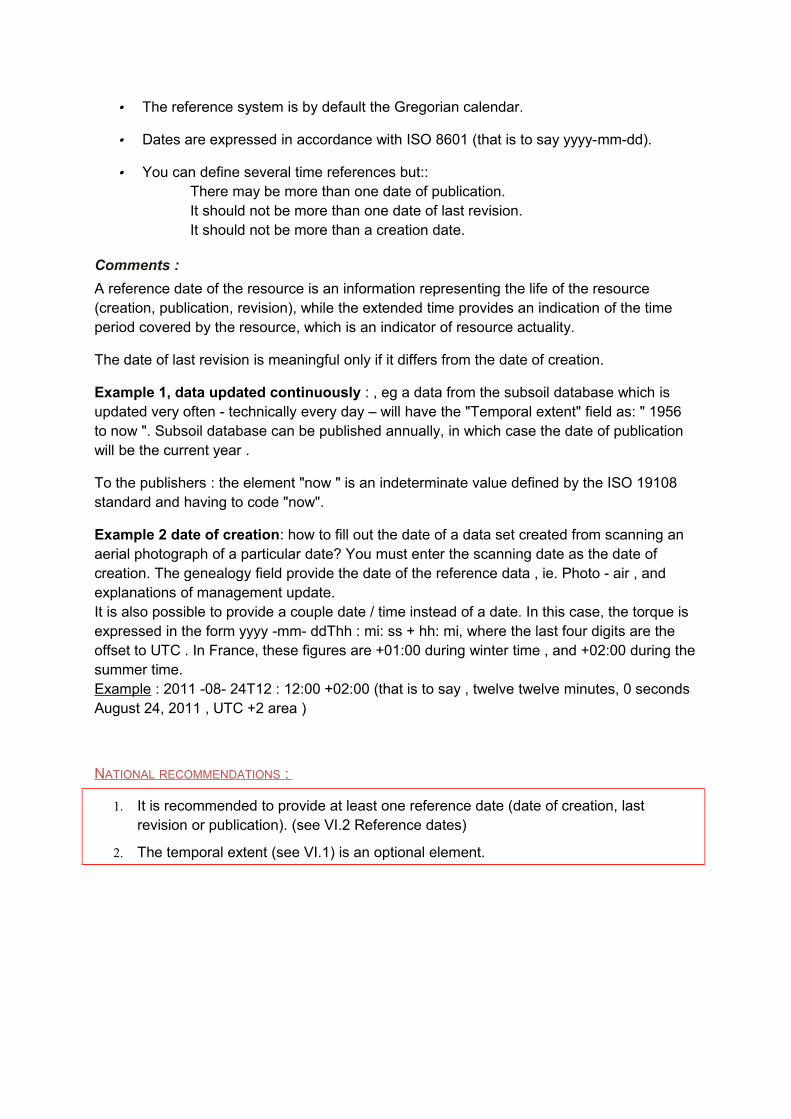
• The reference system is by default the Gregorian calendar.
• Dates are expressed in accordance with ISO 8601 (that is to say yyyy-mm-dd).
• You can define several time references but::There may be more than one date of publication. It should not be more than one date of last revision. It should not be more than a creation date.
Comments :
A reference date of the resource is an information representing the life of the resource (creation, publication, revision), while the extended time provides an indication of the time period covered by the resource, which is an indicator of resource actuality.
The date of last revision is meaningful only if it differs from the date of creation.
Example 1, data updated continuously : , eg a data from the subsoil database which is updated very often - technically every day – will have the "Temporal extent" field as: " 1956 to now ". Subsoil database can be published annually, in which case the date of publication will be the current year .
To the publishers : the element "now " is an indeterminate value defined by the ISO 19108 standard and having to code "now".
Example 2 date of creation: how to fill out the date of a data set created from scanning an aerial photograph of a particular date? You must enter the scanning date as the date of creation. The genealogy field provide the date of the reference data , ie. Photo - air , and explanations of management update.It is also possible to provide a couple date / time instead of a date. In this case, the torque is expressed in the form yyyy -mm- ddThh : mi: ss + hh: mi, where the last four digits are the offset to UTC . In France, these figures are +01:00 during winter time , and +02:00 during the summer time.Example : 2011 -08- 24T12 : 12:00 +02:00 (that is to say , twelve twelve minutes, 0 seconds August 24, 2011 , UTC +2 area )
NATIONAL RECOMMENDATIONS :
1. It is recommended to provide at least one reference date (date of creation, last revision or publication). (see VI.2 Reference dates)
2. The temporal extent (see VI.1) is an optional element.
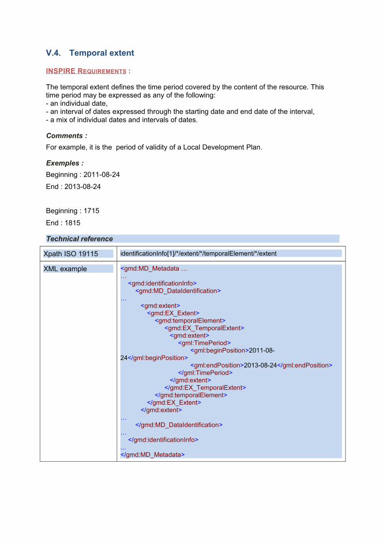
V.4. Temporal extent
INSPIRE REQUIREMENTS :
The temporal extent defines the time period covered by the content of the resource. This time period may be expressed as any of the following:- an individual date,- an interval of dates expressed through the starting date and end date of the interval,- a mix of individual dates and intervals of dates.
Comments :
For example, it is the period of validity of a Local Development Plan.
Exemples :
Beginning : 2011-08-24
End : 2013-08-24
Beginning : 1715
End : 1815
Technical reference
Xpath ISO 19115 identificationInfo[1]/*/extent/*/temporalElement/*/extent
XML example <gmd:MD_Metadata ……
<gmd:identificationInfo><gmd:MD_DataIdentification>
…<gmd:extent>
<gmd:EX_Extent><gmd:temporalElement>
<gmd:EX_TemporalExtent><gmd:extent>
<gml:TimePeriod><gml:beginPosition>2011-08-
24</gml:beginPosition><gml:endPosition>2013-08-24</gml:endPosition>
</gml:TimePeriod></gmd:extent>
</gmd:EX_TemporalExtent></gmd:temporalElement>
</gmd:EX_Extent></gmd:extent>
…</gmd:MD_DataIdentification>
…</gmd:identificationInfo>
...</gmd:MD_Metadata>
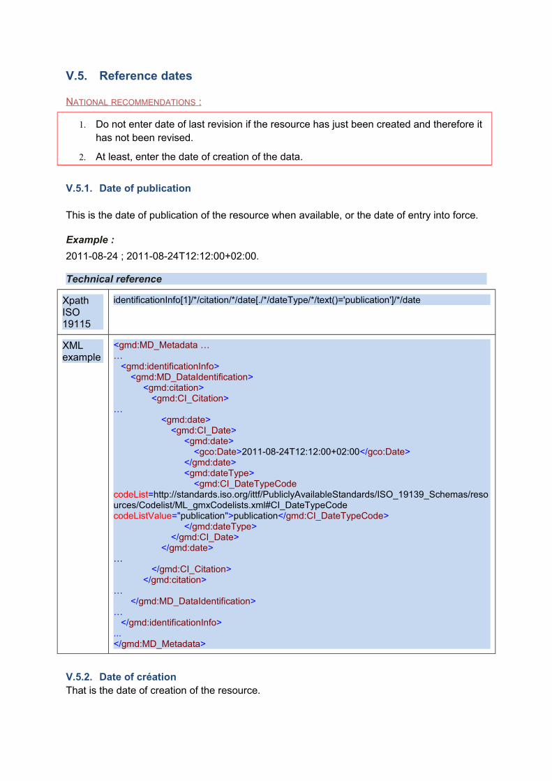
V.5. Reference dates
NATIONAL RECOMMENDATIONS :
1. Do not enter date of last revision if the resource has just been created and therefore it has not been revised.
2. At least, enter the date of creation of the data.
V.5.1. Date of publication
This is the date of publication of the resource when available, or the date of entry into force.
Example :
2011-08-24 ; 2011-08-24T12:12:00+02:00.
Technical reference
Xpath ISO 19115
identificationInfo[1]/*/citation/*/date[./*/dateType/*/text()='publication']/*/date
XML example
<gmd:MD_Metadata ……
<gmd:identificationInfo><gmd:MD_DataIdentification>
<gmd:citation><gmd:CI_Citation>
…<gmd:date>
<gmd:CI_Date><gmd:date>
<gco:Date>2011-08-24T12:12:00+02:00</gco:Date></gmd:date><gmd:dateType>
<gmd:CI_DateTypeCode codeList=http://standards.iso.org/ittf/PubliclyAvailableStandards/ISO_19139_Schemas/resources/Codelist/ML_gmxCodelists.xml#CI_DateTypeCode codeListValue="publication">publication</gmd:CI_DateTypeCode>
</gmd:dateType></gmd:CI_Date>
</gmd:date>…
</gmd:CI_Citation></gmd:citation>
…</gmd:MD_DataIdentification>
…</gmd:identificationInfo>
...</gmd:MD_Metadata>
V.5.2. Date of créationThat is the date of creation of the resource.

Comments
This is the date of creation of the data set or data set series, but not the date of creation of the real-world objects described. Typically, if the data set is a photograph taken May 15, 2000 a historic building dating from 1920, the date of creation of the resource is 15 May 2000.
Example :
2011-08-20
Technical reference
Xpath ISO 19115
identificationInfo[1]/*/citation/*/date[./*/dateType/*/text()='creation']/*/date
XML example
<gmd:MD_Metadata ……
<gmd:identificationInfo><gmd:MD_DataIdentification>
<gmd:citation><gmd:CI_Citation>
…<gmd:date>
<gmd:CI_Date><gmd:date>
<gco:Date>2011-08-20</gco:Date></gmd:date><gmd:dateType>
<gmd:CI_DateTypeCode codeList=http://standards.iso.org/ittf/PubliclyAvailableStandards/ISO_19139_Schemas/resources/Codelist/ML_gmxCodelists.xml#CI_DateTypeCode codeListValue="creation">creation</gmd:CI_DateTypeCode>
</gmd:dateType></gmd:CI_Date>
</gmd:date>…
</gmd:CI_Citation></gmd:citation>
…</gmd:MD_DataIdentification>
…</gmd:identificationInfo>
...</gmd:MD_Metadata>
V.5.3. Date of last revision
This is the date of last revision of the resource, if the resource has been revised. There shall not be more than one date of last revision.
Example :
2011-12-01
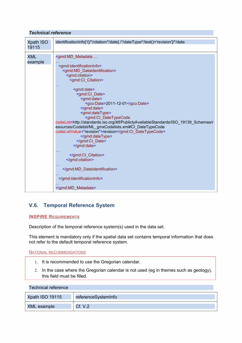
Technical reference
Xpath ISO 19115
identificationInfo[1]/*/citation/*/date[./*/dateType/*/text()='revision']/*/date
XML example
<gmd:MD_Metadata ……
<gmd:identificationInfo><gmd:MD_DataIdentification>
<gmd:citation><gmd:CI_Citation>
…<gmd:date>
<gmd:CI_Date><gmd:date>
<gco:Date>2011-12-01</gco:Date></gmd:date><gmd:dateType>
<gmd:CI_DateTypeCode codeList=http://standards.iso.org/ittf/PubliclyAvailableStandards/ISO_19139_Schemas/resources/Codelist/ML_gmxCodelists.xml#CI_DateTypeCode codeListValue="revision">revision</gmd:CI_DateTypeCode>
</gmd:dateType></gmd:CI_Date>
</gmd:date>…
</gmd:CI_Citation></gmd:citation>
…</gmd:MD_DataIdentification>
…</gmd:identificationInfo>
...</gmd:MD_Metadata>
V.6. Temporal Reference System
INSPIRE REQUIREMENTS
Description of the temporal reference system(s) used in the data set.
This element is mandatory only if the spatial data set contains temporal information that does not refer to the default temporal reference system.
NATIONAL RECOMMENDATIONS
1. It is recommended to use the Gregorian calendar.
2. In the case where the Gregorian calendar is not used (eg in themes such as geology), this field must be filled.
Technical reference
Xpath ISO 19115 referenceSystemInfo
XML example Cf. V.2
VI. Quality et validity
VI.1. Lineage
INSPIRE REQUIREMENTS :
Lineage is a statement on process history and/or overall quality of the spatial data set. Where appropriate it may include a statement whether the data set has been validated or quality assured, whether it is the official version (if multiple versions exist), and whether it has legal validity.
This mandatory metadata element is free text. It is not repeatable.
Comments :
Lineage describes the history of a data set and, if known, the life cycle of it, since the acquisition and capture the data to its compilation with other data sets and variations of its current form. The aim is to make a literal and concise description either the history of the dataset or means, procedures or data processing implemented to capture the dataset. For example, lineage can record the scale input if this information is important for the use of the dataset. The date or version of the data source is also a useful element. A link to an external document resource (it can be a PDF) describing such a process of transformation, can be inserted.
Example :
1/ Transformation to Cartorisque standard of MapInfo files given by Prefecture of Police in Paris to the directorate of major hazards. They were used to realise the annexes of Flood prevention plan of Paris.
2 / The method used, called hydrogeomorphological method, gives a description of the functional floodplain of rivers, shaped by their successive floods, defining the different morphodynamic structures that compose it. It allows to map the maximum envelope of the floodplain, and also provides evidence on the dynamics of the flood. This approach is complemented by a historical approach (raw marks, envelopes flooded areas, archives or from testimonies data). These atlases consist of a mapping using GIS at 1:25000 scale, or 1:10 000 for urbanized areas, as well as an introductory report of the watershed that provides input mapping for each homogeneous sector identified.
3 / scanned network from a 1992's EDR (reproduction element) at 1:25 000.
Technical reference
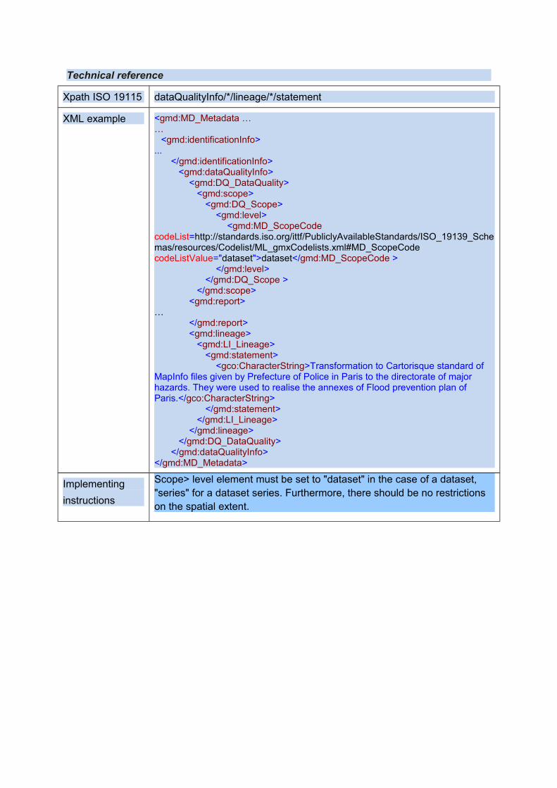
Xpath ISO 19115 dataQualityInfo/*/lineage/*/statement
XML example <gmd:MD_Metadata ……
<gmd:identificationInfo>...
</gmd:identificationInfo><gmd:dataQualityInfo>
<gmd:DQ_DataQuality><gmd:scope>
<gmd:DQ_Scope><gmd:level>
<gmd:MD_ScopeCode codeList=http://standards.iso.org/ittf/PubliclyAvailableStandards/ISO_19139_Schemas/resources/Codelist/ML_gmxCodelists.xml#MD_ScopeCode codeListValue="dataset">dataset</gmd:MD_ScopeCode >
</gmd:level></gmd:DQ_Scope >
</gmd:scope><gmd:report>
…</gmd:report><gmd:lineage>
<gmd:LI_Lineage><gmd:statement>
<gco:CharacterString>Transformation to Cartorisque standard of MapInfo files given by Prefecture of Police in Paris to the directorate of major hazards. They were used to realise the annexes of Flood prevention plan of Paris.</gco:CharacterString>
</gmd:statement></gmd:LI_Lineage>
</gmd:lineage></gmd:DQ_DataQuality>
</gmd:dataQualityInfo></gmd:MD_Metadata>
Implementing
instructions
Scope> level element must be set to "dataset" in the case of a dataset, "series" for a dataset series. Furthermore, there should be no restrictions on the spatial extent.
VI.2. Spatial resolution
INSPIRE REQUIREMENTS :
• Spatial resolution refers to the level of detail of the data set. It shall be expressed as a set of zero to many resolution distances (typically for gridded data and imagery-derived products) or equivalent scales (typically for maps or map-derived products).
• An equivalent scale is generally expressed as an integer value expressing the scale denominator.
• A resolution distance shall be expressed as a numerical value associated with a unit of length
• This element is repeatable and mandatory for spatial datasets and series for which an equivalent scale or a resolution distance can be given.
Comments :
Extract from the document "The quality of spatial data" CERTU, 2010: "this quantity is expressed either by a scale for vector data type or by a distance for data raster type.(...) The concept of scale proposed by INSPIRE to characterize the spatial resolution of a vector dataset is very subjective and opened to interpretation."
Most of the time, for vector data, this lead to note the scale of source data. Otherwise, it is the optimum scale to use the data.
NATIONAL RECOMMENDATIONS :
1. Spatial resolution must be provided for all spatial data (sets and series). An exception is made for statistics.
Example :
● for an equivalent scale :● denominator : 5000
● for a resolution distance :● value : 2 ● unit of measurement : m
Cons-examples:
● 1/5000● 5 000● 5000e● 5000eme● 2 meters
Technical reference
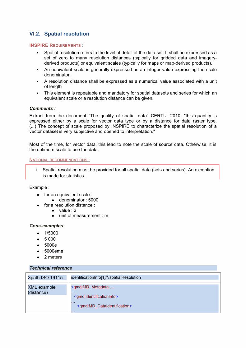
Xpath ISO 19115 identificationInfo[1]/*/spatialResolution
XML example (distance)
<gmd:MD_Metadata ……
<gmd:identificationInfo>…
<gmd:MD_DataIdentification>…
<gmd:spatialResolution><gmd:MD_Resolution>
<gmd:distance><gco:Distance uom="m">25.0</gco:Distance>
</gmd:distance></gmd:MD_Resolution>
</gmd:spatialResolution>…
</gmd:MD_DataIdentification></gmd:identificationInfo>
…</gmd:MD_Metadata>
XML example (equivalent scale)
<gmd:MD_Metadata ……
<gmd:identificationInfo>…
<gmd:MD_DataIdentification>…
<gmd:spatialResolution><gmd:MD_Resolution>
<gmd:equivalentScale><gmd:MD_RepresentativeFraction>
<gmd:denominator><gco:Integer>5000</gco:Integer>
</gmd:denominator></gmd:MD_RepresentativeFraction>
</gmd:equivalentScale></gmd:MD_Resolution>
</gmd:spatialResolution>…
</gmd:MD_DataIdentification></gmd:identificationInfo>
…</gmd:MD_Metadata>
VI.3. Topological Consistency
This metadata element is currently mandatory for the INSPIRE data themes Hydrography and Transport Networks.
INSPIRE REQUIREMENTS :
• Correctness of the explicitly encoded topological characteristics of the data set as described by the scope
• This element is mandatory only if the dataset includes types from the generic network model ("Generic Network Model") and does not provide the network topology (eg. connectivity of central lines).
Comments
Practically, are concerned the data compliant with the requirements of INSPIRE and under the network model (hydrography, transportation, utilities). The technical guidelines for INSPIRE themes define the measures to be applied according to the themes. For example: - invalid number of overlays, - number of pending nodes (undershoot, overshoot)
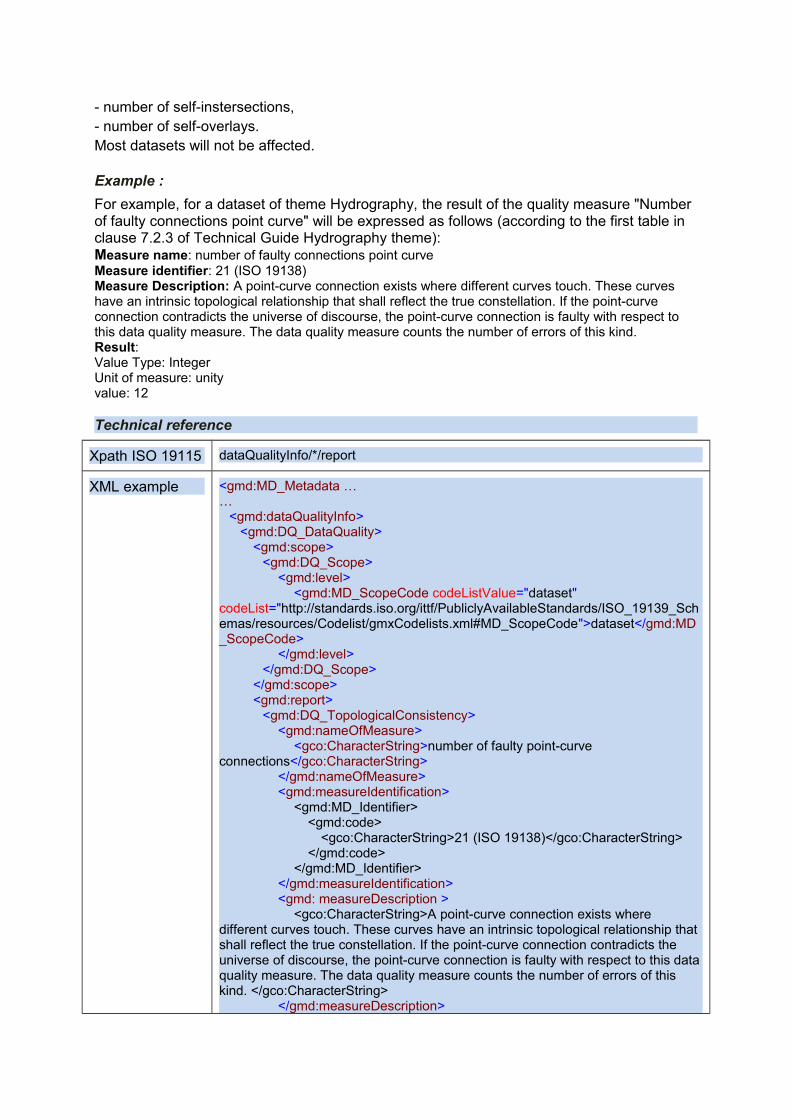
- number of self-instersections, - number of self-overlays. Most datasets will not be affected.
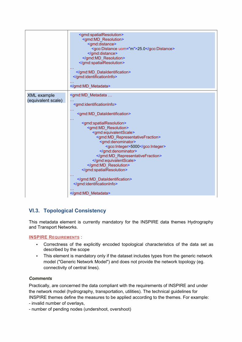
Example :
For example, for a dataset of theme Hydrography, the result of the quality measure "Number of faulty connections point curve" will be expressed as follows (according to the first table in clause 7.2.3 of Technical Guide Hydrography theme): Measure name: number of faulty connections point curve Measure identifier: 21 (ISO 19138) Measure Description: A point-curve connection exists where different curves touch. These curves have an intrinsic topological relationship that shall reflect the true constellation. If the point-curve connection contradicts the universe of discourse, the point-curve connection is faulty with respect to this data quality measure. The data quality measure counts the number of errors of this kind. Result: Value Type: Integer Unit of measure: unity value: 12
Technical reference
Xpath ISO 19115 dataQualityInfo/*/report
XML example <gmd:MD_Metadata ……
<gmd:dataQualityInfo><gmd:DQ_DataQuality>
<gmd:scope><gmd:DQ_Scope>
<gmd:level><gmd:MD_ScopeCode codeListValue="dataset"
codeList="http://standards.iso.org/ittf/PubliclyAvailableStandards/ISO_19139_Schemas/resources/Codelist/gmxCodelists.xml#MD_ScopeCode">dataset</gmd:MD_ScopeCode>
</gmd:level></gmd:DQ_Scope>
</gmd:scope><gmd:report>
<gmd:DQ_TopologicalConsistency><gmd:nameOfMeasure>
<gco:CharacterString>number of faulty point-curve connections</gco:CharacterString>
</gmd:nameOfMeasure><gmd:measureIdentification>
<gmd:MD_Identifier><gmd:code>
<gco:CharacterString>21 (ISO 19138)</gco:CharacterString></gmd:code>
</gmd:MD_Identifier></gmd:measureIdentification><gmd: measureDescription >
<gco:CharacterString>A point-curve connection exists where different curves touch. These curves have an intrinsic topological relationship that shall reflect the true constellation. If the point-curve connection contradicts the universe of discourse, the point-curve connection is faulty with respect to this data quality measure. The data quality measure counts the number of errors of this kind. </gco:CharacterString>
</gmd:measureDescription>
<gmd:result><gmd:DQ_QuantitativeResult>
<gmd:valueType><gco:RecordType
xlink:href="http://www.w3.org/2001/XMLSchema.xsd#integer">Integer</gco:RecordType>
</gmd:valueType><gmd:valueUnit
xlink:href="http://www.opengis.net/def/uom/OGC/1.0/unity"/><gmd:value>
<gco:Record xsi:type="xs:integer">12</gco:Record></gmd:value>
</gmd:DQ_QuantitativeResult></gmd:result>
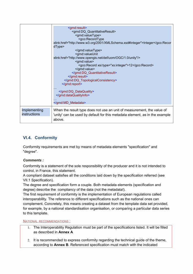
</gmd:DQ_TopologicalConsistency></gmd:report>
…</gmd:DQ_DataQuality>
</gmd:dataQualityInfo>…</gmd:MD_Metadata>
Implementing instructions
When the result type does not use an unit of measurement, the value of 'unity' can be used by default for this metadata element, as in the example above.
VI.4. Conformity
Conformity requirements are met by means of metadata elements "specification" and "degree".
Comments :
Conformity is a statement of the sole responsibility of the producer and it is not intended to control, in France, this statement. A compliant dataset satisfies all the conditions laid down by the specification referred (see VII.1 Specification). The degree and specification form a couple. Both metadata elements (specification and degree) describe the compliancy of the data (not the metadata!). The first requirement of conformity is the implementation of European regulations called interoperability. The reference to different specifications such as the national ones can complement. Concretely, this means creating a dataset from the template data set provided, for example, by a national standardisation organisation, or comparing a particular data series to this template.
NATIONAL RECOMMENDATIONS :
1. The Interoperability Regulation must be part of the specifications listed. It will be filled as described in Annex A
2. It is recommended to express conformity regarding the technical guide of the theme, according to Annex B. Referenced specification must match with the indicated
INSPIRE theme keyword.
3. Most of the time, it is advisable to separate its resource following the INSPIRE themes, to have to conform to only one data model of INSPIRE (for example, the Carto database of IGN-FR was separate into several datasets : BD Carto - Hydrography, BD Carto - road Network, BD Carto - cadastral parcels, etc).
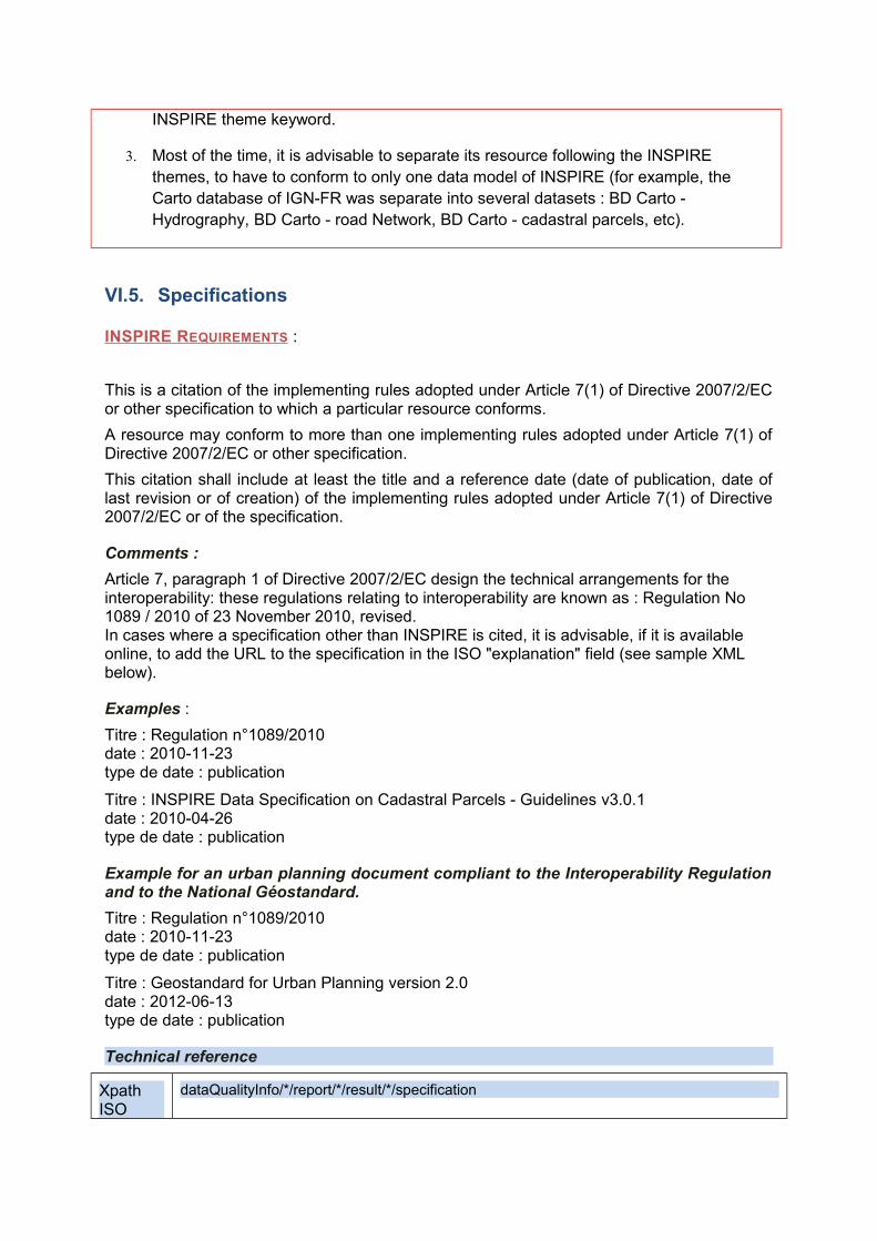
VI.5. Specifications
INSPIRE REQUIREMENTS :
This is a citation of the implementing rules adopted under Article 7(1) of Directive 2007/2/EC or other specification to which a particular resource conforms.
A resource may conform to more than one implementing rules adopted under Article 7(1) of Directive 2007/2/EC or other specification.
This citation shall include at least the title and a reference date (date of publication, date of last revision or of creation) of the implementing rules adopted under Article 7(1) of Directive 2007/2/EC or of the specification.
Comments :
Article 7, paragraph 1 of Directive 2007/2/EC design the technical arrangements for the interoperability: these regulations relating to interoperability are known as : Regulation No 1089 / 2010 of 23 November 2010, revised. In cases where a specification other than INSPIRE is cited, it is advisable, if it is available online, to add the URL to the specification in the ISO "explanation" field (see sample XML below).
Examples :
Titre : Regulation n°1089/2010date : 2010-11-23type de date : publication
Titre : INSPIRE Data Specification on Cadastral Parcels - Guidelines v3.0.1date : 2010-04-26type de date : publication
Example for an urban planning document compliant to the Interoperability Regulation and to the National Géostandard.
Titre : Regulation n°1089/2010date : 2010-11-23type de date : publication
Titre : Geostandard for Urban Planning version 2.0date : 2012-06-13type de date : publication
Technical reference
Xpath ISO
dataQualityInfo/*/report/*/result/*/specification
19115
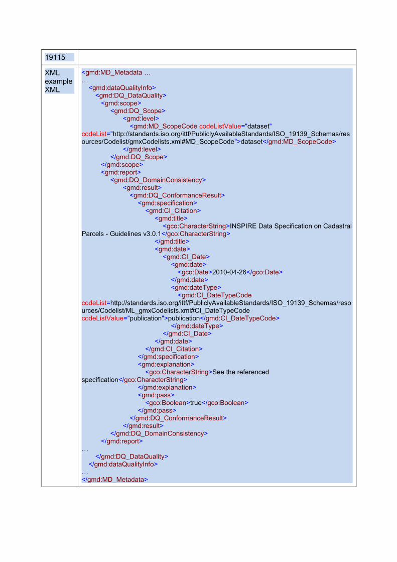
XML example XML
<gmd:MD_Metadata ……
<gmd:dataQualityInfo><gmd:DQ_DataQuality>
<gmd:scope><gmd:DQ_Scope>
<gmd:level><gmd:MD_ScopeCode codeListValue="dataset"
codeList="http://standards.iso.org/ittf/PubliclyAvailableStandards/ISO_19139_Schemas/resources/Codelist/gmxCodelists.xml#MD_ScopeCode">dataset</gmd:MD_ScopeCode>
</gmd:level></gmd:DQ_Scope>
</gmd:scope><gmd:report>
<gmd:DQ_DomainConsistency><gmd:result>
<gmd:DQ_ConformanceResult><gmd:specification>
<gmd:CI_Citation><gmd:title>
<gco:CharacterString>INSPIRE Data Specification on Cadastral Parcels - Guidelines v3.0.1</gco:CharacterString>
</gmd:title><gmd:date>
<gmd:CI_Date><gmd:date>
<gco:Date>2010-04-26</gco:Date></gmd:date><gmd:dateType>
<gmd:CI_DateTypeCode codeList=http://standards.iso.org/ittf/PubliclyAvailableStandards/ISO_19139_Schemas/resources/Codelist/ML_gmxCodelists.xml#CI_DateTypeCode codeListValue="publication">publication</gmd:CI_DateTypeCode>
</gmd:dateType></gmd:CI_Date>
</gmd:date></gmd:CI_Citation>
</gmd:specification><gmd:explanation>
<gco:CharacterString>See the referenced specification</gco:CharacterString>
</gmd:explanation><gmd:pass>
<gco:Boolean>true</gco:Boolean></gmd:pass>
</gmd:DQ_ConformanceResult></gmd:result>
</gmd:DQ_DomainConsistency></gmd:report>
…</gmd:DQ_DataQuality>
</gmd:dataQualityInfo>…</gmd:MD_Metadata>
VI.6. Degree of conformity
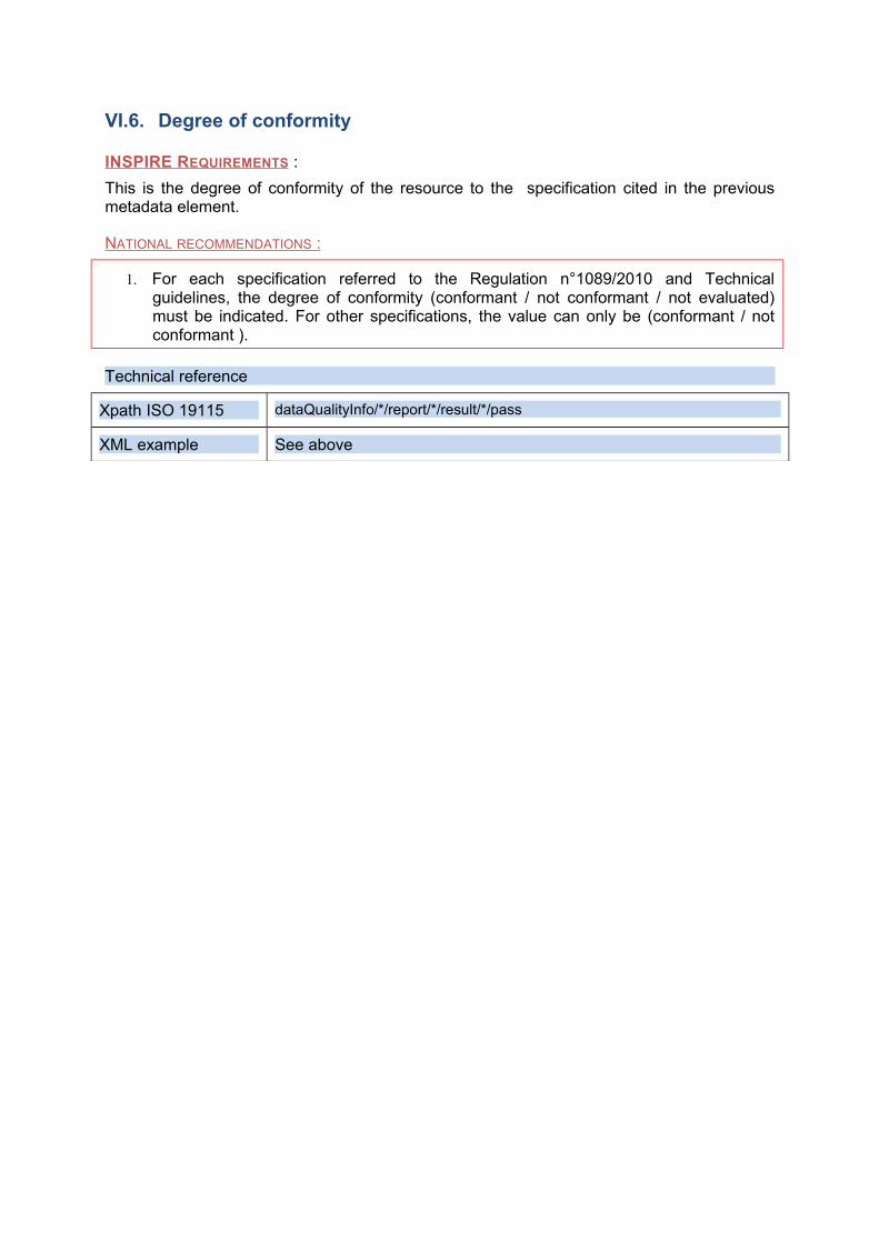
INSPIRE REQUIREMENTS :
This is the degree of conformity of the resource to the specification cited in the previous metadata element.
NATIONAL RECOMMENDATIONS :
1. For each specification referred to the Regulation n°1089/2010 and Technical guidelines, the degree of conformity (conformant / not conformant / not evaluated) must be indicated. For other specifications, the value can only be (conformant / not conformant ).
Technical reference
Xpath ISO 19115 dataQualityInfo/*/report/*/result/*/pass
XML example See above
VII. Constraint related to access and use
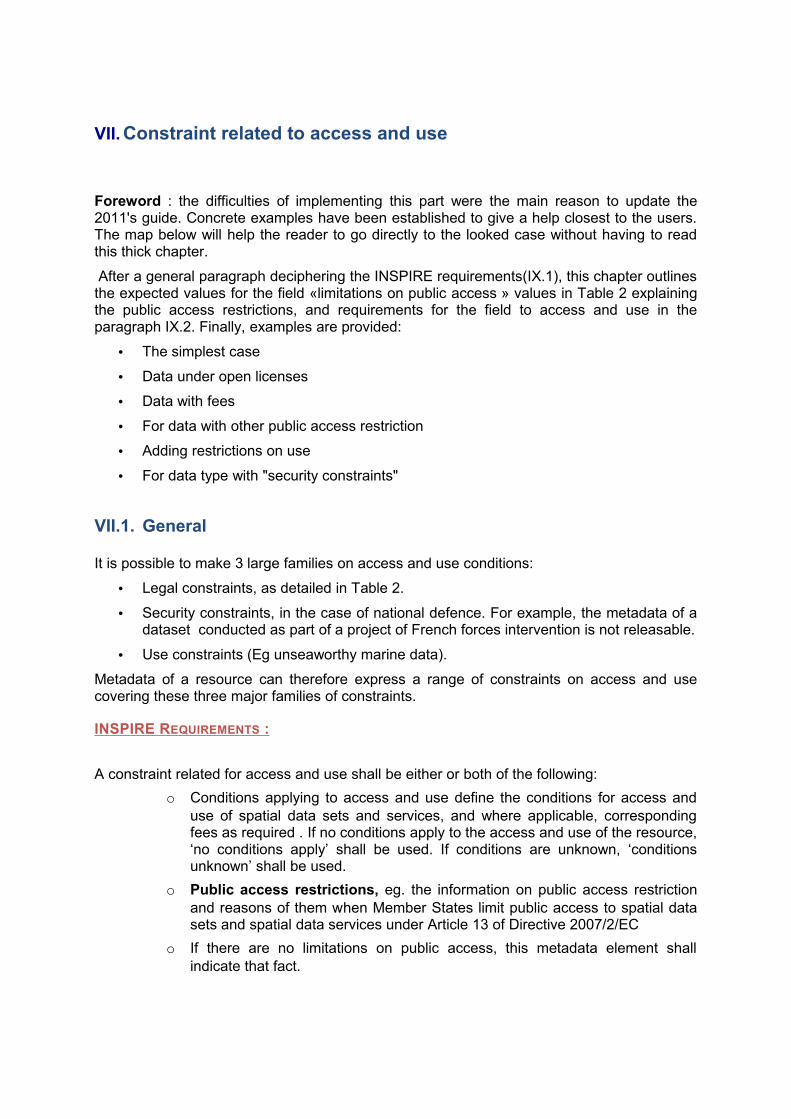
Foreword : the difficulties of implementing this part were the main reason to update the 2011's guide. Concrete examples have been established to give a help closest to the users. The map below will help the reader to go directly to the looked case without having to read this thick chapter.
After a general paragraph deciphering the INSPIRE requirements(IX.1), this chapter outlines the expected values for the field «limitations on public access » values in Table 2 explaining the public access restrictions, and requirements for the field to access and use in the paragraph IX.2. Finally, examples are provided:
• The simplest case
• Data under open licenses
• Data with fees
• For data with other public access restriction
• Adding restrictions on use
• For data type with "security constraints"
VII.1. General
It is possible to make 3 large families on access and use conditions:
• Legal constraints, as detailed in Table 2.
• Security constraints, in the case of national defence. For example, the metadata of a dataset conducted as part of a project of French forces intervention is not releasable.
• Use constraints (Eg unseaworthy marine data).
Metadata of a resource can therefore express a range of constraints on access and use covering these three major families of constraints.
INSPIRE REQUIREMENTS :
A constraint related for access and use shall be either or both of the following:
o Conditions applying to access and use define the conditions for access and use of spatial data sets and services, and where applicable, corresponding fees as required . If no conditions apply to the access and use of the resource, ‘no conditions apply’ shall be used. If conditions are unknown, ‘conditions unknown’ shall be used.
o Public access restrictions, eg. the information on public access restriction and reasons of them when Member States limit public access to spatial data sets and spatial data services under Article 13 of Directive 2007/2/EC
o If there are no limitations on public access, this metadata element shall indicate that fact.
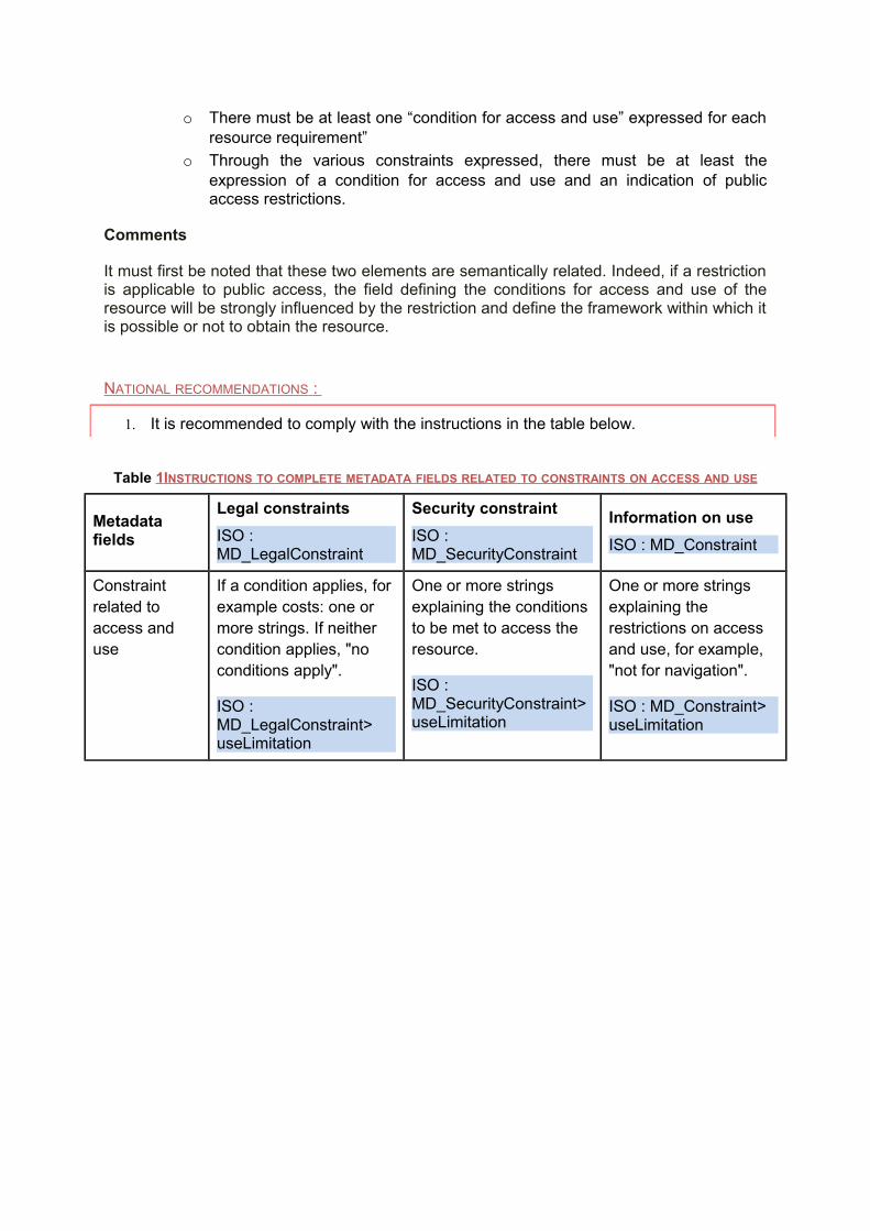
o There must be at least one “condition for access and use” expressed for each resource requirement”
o Through the various constraints expressed, there must be at least the expression of a condition for access and use and an indication of public access restrictions.
Comments
It must first be noted that these two elements are semantically related. Indeed, if a restriction is applicable to public access, the field defining the conditions for access and use of the resource will be strongly influenced by the restriction and define the framework within which it is possible or not to obtain the resource.
NATIONAL RECOMMENDATIONS :
1. It is recommended to comply with the instructions in the table below.
Table 1 INSTRUCTIONS TO COMPLETE METADATA FIELDS RELATED TO CONSTRAINTS ON ACCESS AND USE
Metadata fields
Legal constraints
ISO : MD_LegalConstraint
Security constraint
ISO : MD_SecurityConstraint
Information on use
ISO : MD_Constraint
Constraint related to access and use
If a condition applies, for example costs: one or more strings. If neither condition applies, "no conditions apply".
ISO : MD_LegalConstraint>useLimitation
One or more strings explaining the conditions to be met to access the resource.
ISO : MD_SecurityConstraint>useLimitation
One or more strings explaining the restrictions on access and use, for example, "not for navigation".
ISO : MD_Constraint>useLimitation
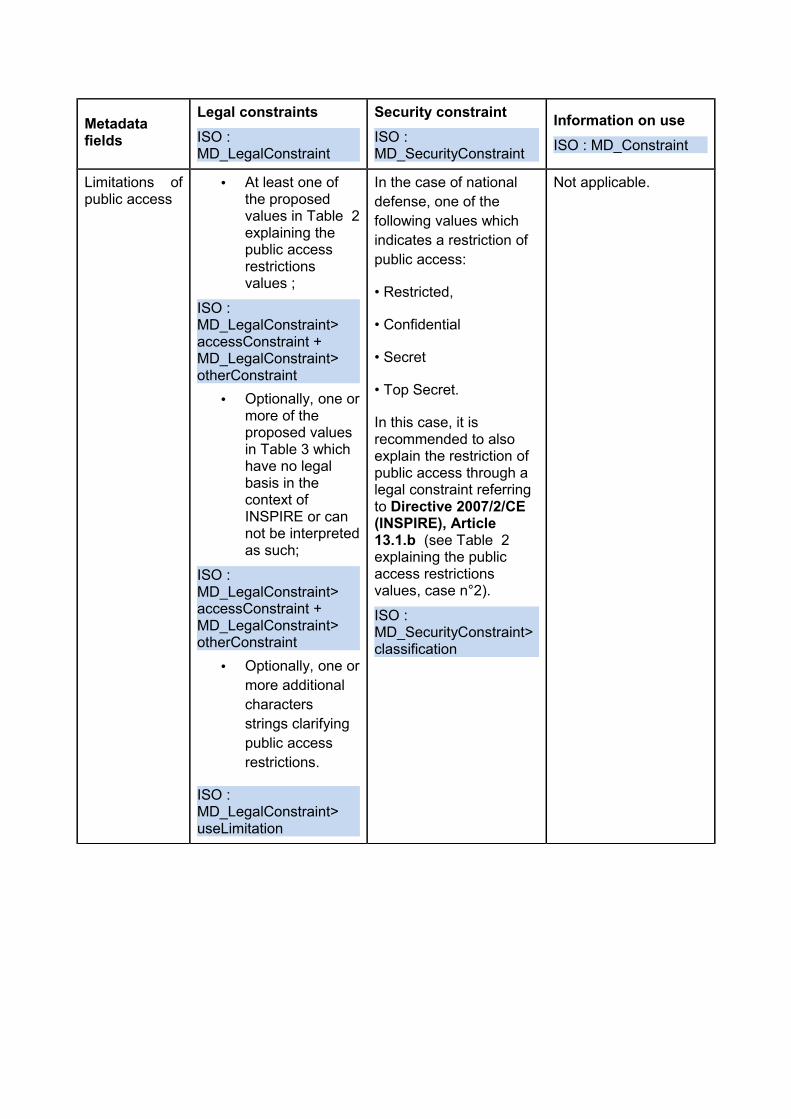
Metadata fields
Legal constraints
ISO : MD_LegalConstraint
Security constraint
ISO : MD_SecurityConstraint
Information on use
ISO : MD_Constraint
Limitations of public access
• At least one of the proposed values in Table 2explaining the public access restrictions values ;
ISO : MD_LegalConstraint>accessConstraint +MD_LegalConstraint>otherConstraint
• Optionally, one or more of the proposed values in Table 3 which have no legal basis in the context of INSPIRE or can not be interpreted as such;
ISO : MD_LegalConstraint>accessConstraint +MD_LegalConstraint>otherConstraint
• Optionally, one or more additional characters strings clarifying public access restrictions.
ISO : MD_LegalConstraint>useLimitation
In the case of national defense, one of the following values which indicates a restriction of public access:
• Restricted,
• Confidential
• Secret
• Top Secret.
In this case, it is recommended to also explain the restriction of public access through a legal constraint referring to Directive 2007/2/CE (INSPIRE), Article 13.1.b (see Table 2 explaining the public access restrictions values, case n°2).
ISO : MD_SecurityConstraint>classification
Not applicable.
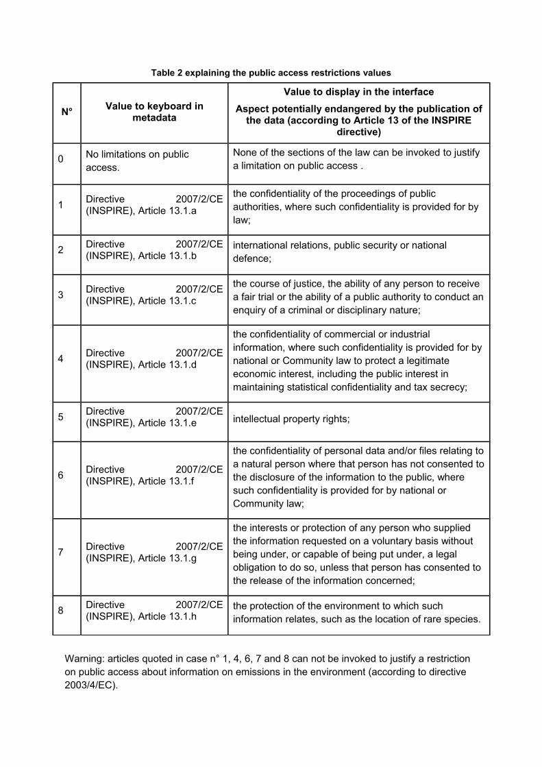
Table 2 explaining the public access restrictions values
N°Value to keyboard in
metadata
Value to display in the interface
Aspect potentially endangered by the publication of the data (according to Article 13 of the INSPIRE
directive)
0 No limitations on public access.
None of the sections of the law can be invoked to justify a limitation on public access .
1 Directive 2007/2/CE (INSPIRE), Article 13.1.a
the confidentiality of the proceedings of public authorities, where such confidentiality is provided for by law;
2 Directive 2007/2/CE (INSPIRE), Article 13.1.b
international relations, public security or national defence;
3 Directive 2007/2/CE (INSPIRE), Article 13.1.c
the course of justice, the ability of any person to receive a fair trial or the ability of a public authority to conduct an enquiry of a criminal or disciplinary nature;
4 Directive 2007/2/CE (INSPIRE), Article 13.1.d
the confidentiality of commercial or industrial information, where such confidentiality is provided for by national or Community law to protect a legitimate economic interest, including the public interest in maintaining statistical confidentiality and tax secrecy;
5 Directive 2007/2/CE (INSPIRE), Article 13.1.e intellectual property rights;
6 Directive 2007/2/CE (INSPIRE), Article 13.1.f
the confidentiality of personal data and/or files relating to a natural person where that person has not consented to the disclosure of the information to the public, where such confidentiality is provided for by national or Community law;
7 Directive 2007/2/CE (INSPIRE), Article 13.1.g
the interests or protection of any person who supplied the information requested on a voluntary basis without being under, or capable of being put under, a legal obligation to do so, unless that person has consented to the release of the information concerned;
8 Directive 2007/2/CE (INSPIRE), Article 13.1.h
the protection of the environment to which such information relates, such as the location of rare species.
Warning: articles quoted in case n° 1, 4, 6, 7 and 8 can not be invoked to justify a restriction on public access about information on emissions in the environment (according to directive 2003/4/EC).
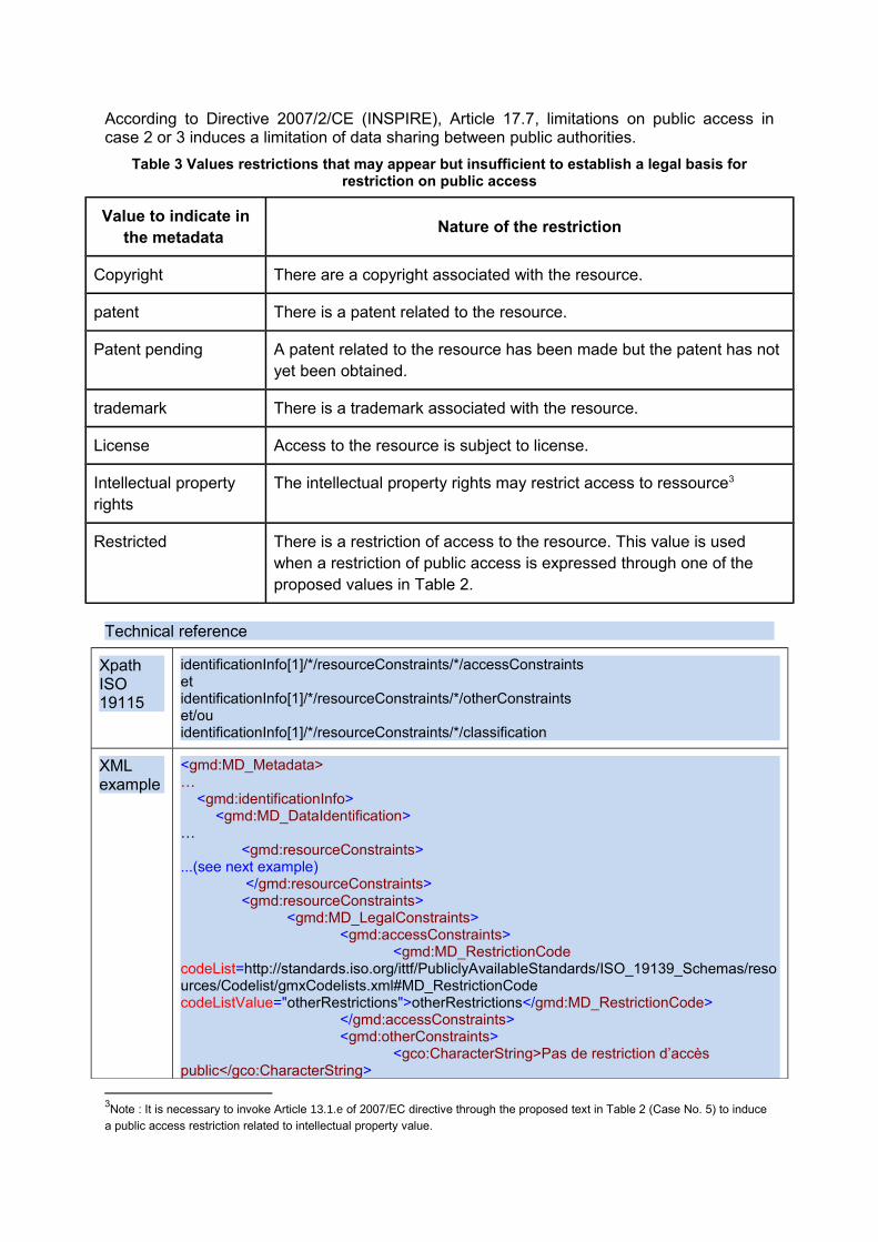
According to Directive 2007/2/CE (INSPIRE), Article 17.7, limitations on public access in case 2 or 3 induces a limitation of data sharing between public authorities.
Table 3 Values restrictions that may appear but insufficient to establish a legal basis for restriction on public access
Value to indicate in the metadata
Nature of the restriction
Copyright There are a copyright associated with the resource.
patent There is a patent related to the resource.
Patent pending A patent related to the resource has been made but the patent has not yet been obtained.
trademark There is a trademark associated with the resource.
License Access to the resource is subject to license.
Intellectual property rights
The intellectual property rights may restrict access to ressource3
Restricted There is a restriction of access to the resource. This value is used when a restriction of public access is expressed through one of the proposed values in Table 2.
Technical reference
Xpath ISO 19115
identificationInfo[1]/*/resourceConstraints/*/accessConstraintsetidentificationInfo[1]/*/resourceConstraints/*/otherConstraintset/ouidentificationInfo[1]/*/resourceConstraints/*/classification
XML example
<gmd:MD_Metadata>…
<gmd:identificationInfo><gmd:MD_DataIdentification>
…<gmd:resourceConstraints>
...(see next example) </gmd:resourceConstraints><gmd:resourceConstraints>
<gmd:MD_LegalConstraints><gmd:accessConstraints>
<gmd:MD_RestrictionCode codeList=http://standards.iso.org/ittf/PubliclyAvailableStandards/ISO_19139_Schemas/resources/Codelist/gmxCodelists.xml#MD_RestrictionCode codeListValue="otherRestrictions">otherRestrictions</gmd:MD_RestrictionCode>
</gmd:accessConstraints><gmd:otherConstraints>
<gco:CharacterString>Pas de restriction d’accès public</gco:CharacterString>
3Note : It is necessary to invoke Article 13.1.e of 2007/EC directive through the proposed text in Table 2 (Case No. 5) to induce
a public access restriction related to intellectual property value.
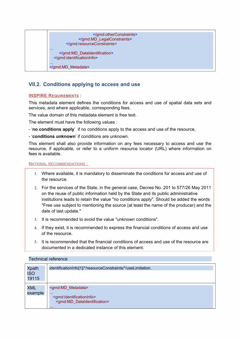
</gmd:otherConstraints></gmd:MD_LegalConstraints>
</gmd:resourceConstraints>…
</gmd:MD_DataIdentification></gmd:identificationInfo>
…</gmd:MD_Metadata>
VII.2. Conditions applying to access and use
INSPIRE REQUIREMENTS :
This metadata element defines the conditions for access and use of spatial data sets and services, and where applicable, corresponding fees.
The value domain of this metadata element is free text.
The element must have the following values :
- ‘no conditions apply’ if no conditions apply to the access and use of the resource,
- ‘conditions unknown’ if conditions are unknown.
This element shall also provide information on any fees necessary to access and use the resource, if applicable, or refer to a uniform resource locator (URL) where information on fees is available.
NATIONAL RECOMMENDATIONS :
1. Where available, it is mandatory to disseminate the conditions for access and use of the resource.
2. For the services of the State, in the general case, Decree No. 201 to 577/26 May 2011 on the reuse of public information held by the State and its public administrative institutions leads to retain the value "no conditions apply". Should be added the words "Free use subject to mentioning the source (at least the name of the producer) and the date of last update."
3. It is recommended to avoid the value "unknown conditions".
4. If they exist, it is recommended to express the financial conditions of access and use of the resource.
5. It is recommended that the financial conditions of access and use of the resource are documented in a dedicated instance of this element.
Technical reference
Xpath ISO 19115
identificationInfo[1]/*/resourceConstraints/*/useLimitation.
XML example
<gmd:MD_Metadata>…
<gmd:identificationInfo><gmd:MD_DataIdentification>
…
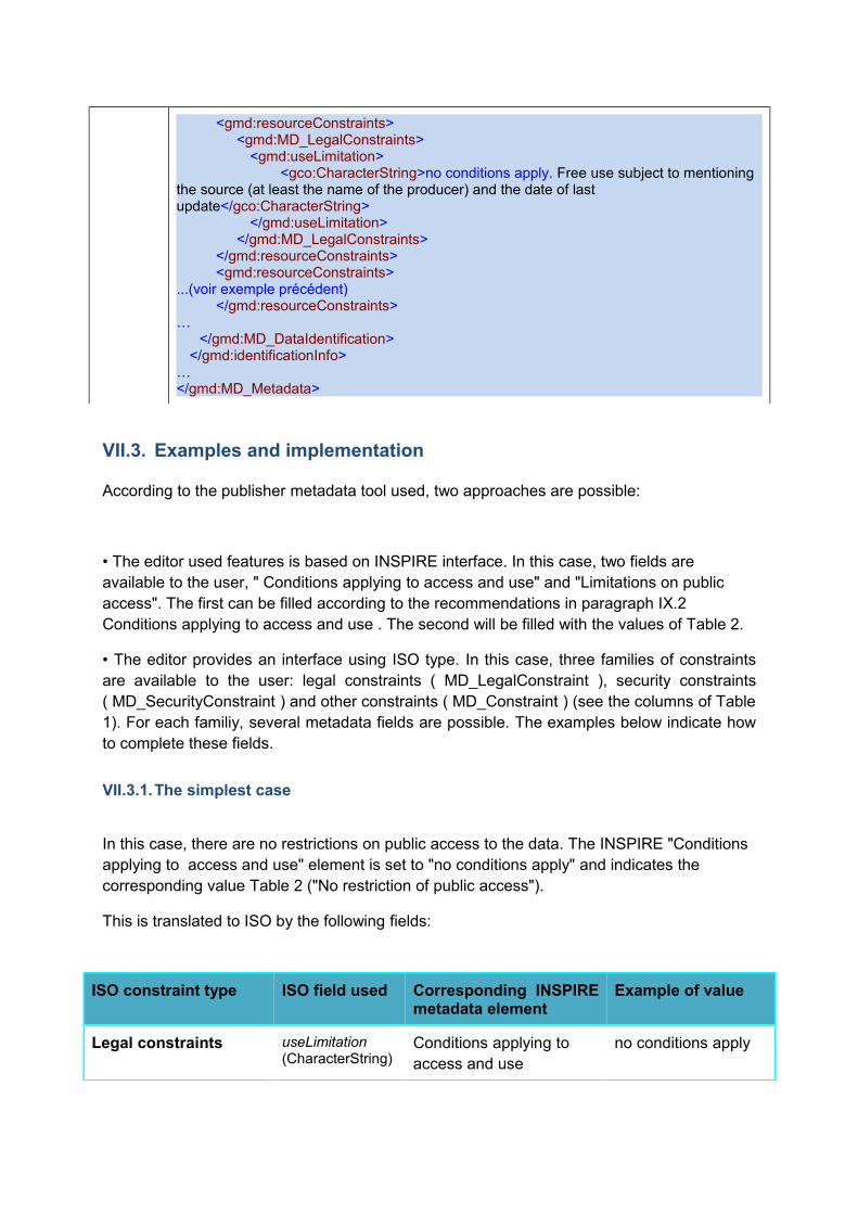
<gmd:resourceConstraints><gmd:MD_LegalConstraints>
<gmd:useLimitation><gco:CharacterString>no conditions apply. Free use subject to mentioning
the source (at least the name of the producer) and the date of last update</gco:CharacterString>
</gmd:useLimitation></gmd:MD_LegalConstraints>
</gmd:resourceConstraints><gmd:resourceConstraints>
...(voir exemple précédent) </gmd:resourceConstraints>
…</gmd:MD_DataIdentification>
</gmd:identificationInfo>…</gmd:MD_Metadata>
VII.3. Examples and implementation
According to the publisher metadata tool used, two approaches are possible:
• The editor used features is based on INSPIRE interface. In this case, two fields are available to the user, " Conditions applying to access and use" and "Limitations on public access". The first can be filled according to the recommendations in paragraph IX.2 Conditions applying to access and use . The second will be filled with the values of Table 2.
• The editor provides an interface using ISO type. In this case, three families of constraints are available to the user: legal constraints ( MD_LegalConstraint ), security constraints ( MD_SecurityConstraint ) and other constraints ( MD_Constraint ) (see the columns of Table 1). For each familiy, several metadata fields are possible. The examples below indicate how to complete these fields.
VII.3.1.The simplest case
In this case, there are no restrictions on public access to the data. The INSPIRE "Conditions applying to access and use" element is set to "no conditions apply" and indicates the corresponding value Table 2 ("No restriction of public access").
This is translated to ISO by the following fields:
ISO constraint type ISO field used Corresponding INSPIRE metadata element
Example of value
Legal constraints useLimitation (CharacterString)
Conditions applying to access and use
no conditions apply
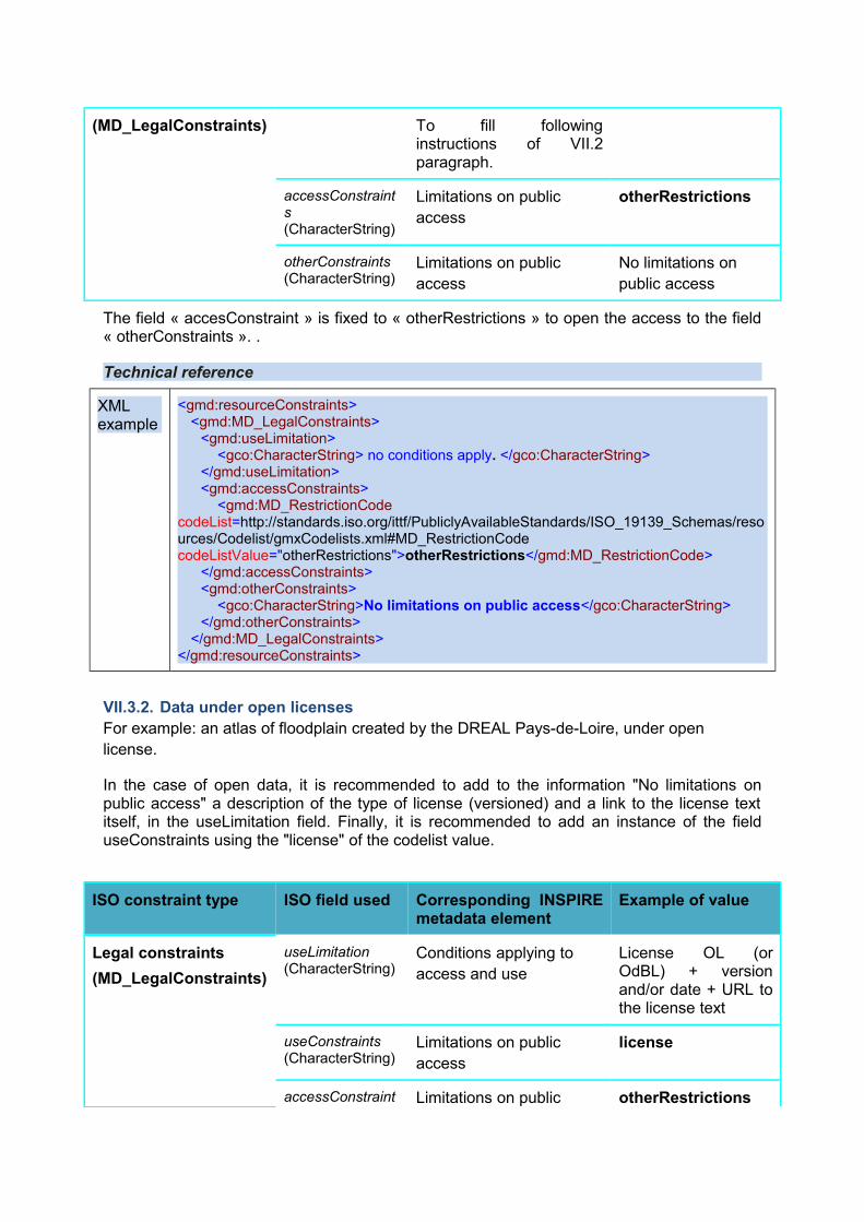
(MD_LegalConstraints) To fill following instructions of VII.2 paragraph.
accessConstraints (CharacterString)
Limitations on public access
otherRestrictions
otherConstraints (CharacterString)
Limitations on public access
No limitations on public access
The field « accesConstraint » is fixed to « otherRestrictions » to open the access to the field « otherConstraints ». .
Technical reference
XML example
<gmd:resourceConstraints><gmd:MD_LegalConstraints>
<gmd:useLimitation><gco:CharacterString> no conditions apply. </gco:CharacterString>
</gmd:useLimitation><gmd:accessConstraints>
<gmd:MD_RestrictionCode codeList=http://standards.iso.org/ittf/PubliclyAvailableStandards/ISO_19139_Schemas/resources/Codelist/gmxCodelists.xml#MD_RestrictionCode codeListValue="otherRestrictions">otherRestrictions</gmd:MD_RestrictionCode>
</gmd:accessConstraints><gmd:otherConstraints>
<gco:CharacterString>No limitations on public access</gco:CharacterString></gmd:otherConstraints>
</gmd:MD_LegalConstraints></gmd:resourceConstraints>
VII.3.2. Data under open licensesFor example: an atlas of floodplain created by the DREAL Pays-de-Loire, under open license.
In the case of open data, it is recommended to add to the information "No limitations on public access" a description of the type of license (versioned) and a link to the license text itself, in the useLimitation field. Finally, it is recommended to add an instance of the field useConstraints using the "license" of the codelist value.
ISO constraint type ISO field used Corresponding INSPIRE metadata element
Example of value
Legal constraints
(MD_LegalConstraints)
useLimitation (CharacterString)
Conditions applying to access and use
License OL (or OdBL) + version and/or date + URL to the license text
useConstraints (CharacterString)
Limitations on public access
license
accessConstraint Limitations on public otherRestrictions
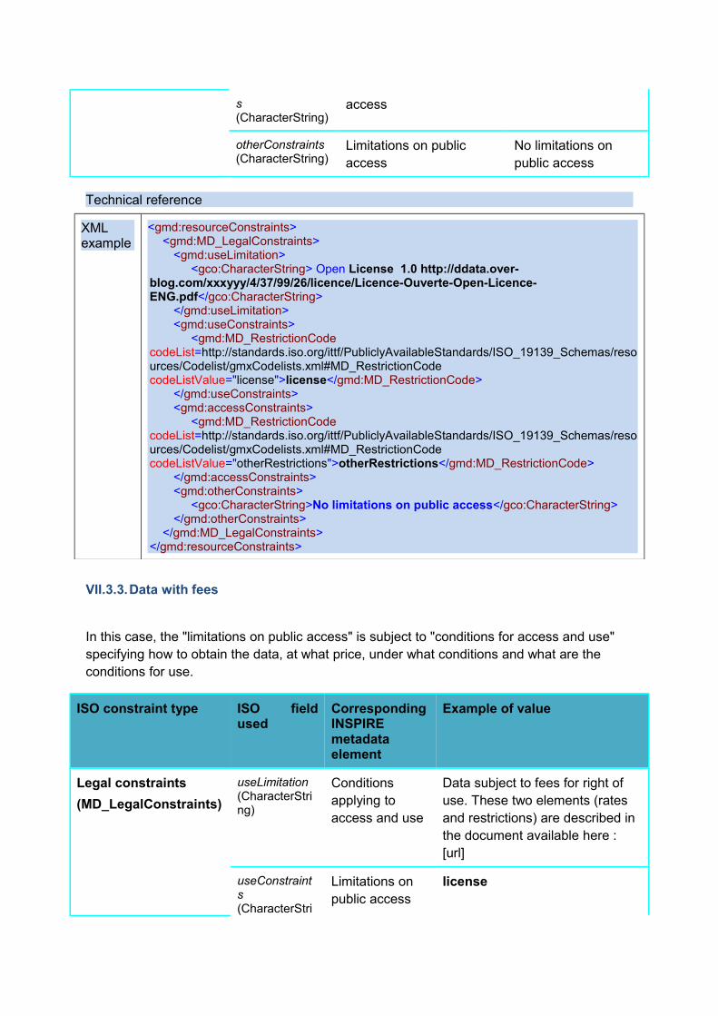
s (CharacterString)
access
otherConstraints (CharacterString)
Limitations on public access
No limitations on public access
Technical reference
XML example
<gmd:resourceConstraints><gmd:MD_LegalConstraints>
<gmd:useLimitation><gco:CharacterString> Open License 1.0 http://ddata.over-
blog.com/xxxyyy/4/37/99/26/licence/Licence-Ouverte-Open-Licence-ENG.pdf</gco:CharacterString>
</gmd:useLimitation><gmd:useConstraints>
<gmd:MD_RestrictionCode codeList=http://standards.iso.org/ittf/PubliclyAvailableStandards/ISO_19139_Schemas/resources/Codelist/gmxCodelists.xml#MD_RestrictionCode codeListValue="license">license</gmd:MD_RestrictionCode>
</gmd:useConstraints><gmd:accessConstraints>
<gmd:MD_RestrictionCode codeList=http://standards.iso.org/ittf/PubliclyAvailableStandards/ISO_19139_Schemas/resources/Codelist/gmxCodelists.xml#MD_RestrictionCode codeListValue="otherRestrictions">otherRestrictions</gmd:MD_RestrictionCode>
</gmd:accessConstraints><gmd:otherConstraints>
<gco:CharacterString>No limitations on public access</gco:CharacterString></gmd:otherConstraints>
</gmd:MD_LegalConstraints></gmd:resourceConstraints>
VII.3.3.Data with fees
In this case, the "limitations on public access" is subject to "conditions for access and use" specifying how to obtain the data, at what price, under what conditions and what are the conditions for use.
ISO constraint type ISO field used
Corresponding INSPIRE metadata element
Example of value
Legal constraints
(MD_LegalConstraints)
useLimitation (CharacterString)
Conditions applying to access and use
Data subject to fees for right of use. These two elements (rates and restrictions) are described in the document available here : [url]
useConstraints (CharacterStri
Limitations on public access
license
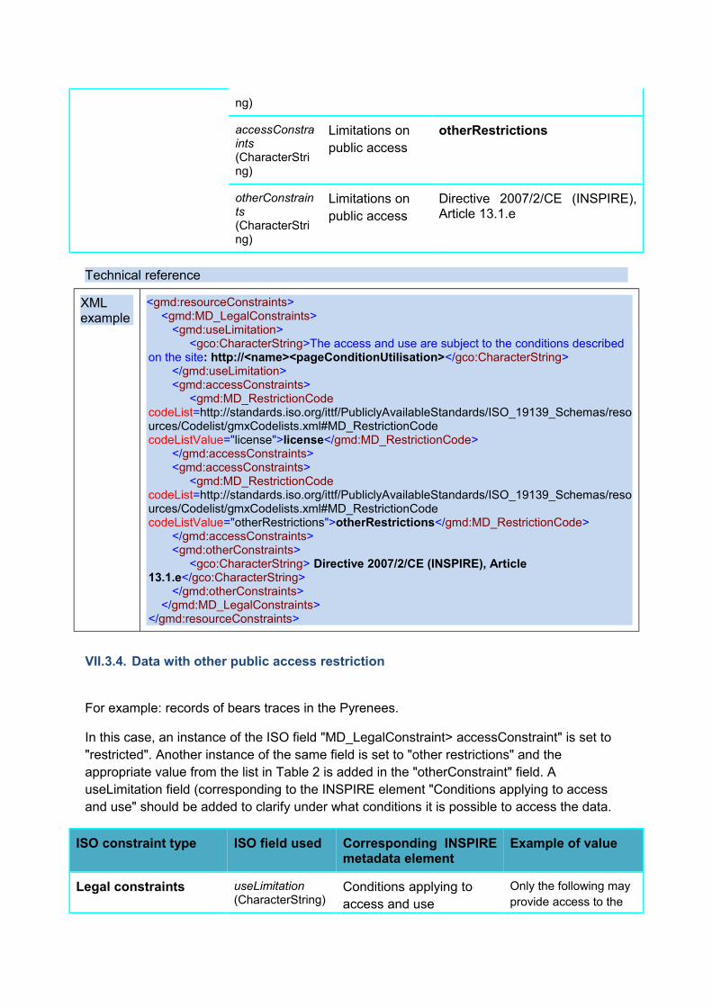
ng)
accessConstraints (CharacterString)
Limitations on public access
otherRestrictions
otherConstraints (CharacterString)
Limitations on public access
Directive 2007/2/CE (INSPIRE), Article 13.1.e
Technical reference
XML example
<gmd:resourceConstraints><gmd:MD_LegalConstraints>
<gmd:useLimitation><gco:CharacterString>The access and use are subject to the conditions described
on the site: http://<name><pageConditionUtilisation></gco:CharacterString></gmd:useLimitation><gmd:accessConstraints>
<gmd:MD_RestrictionCode codeList=http://standards.iso.org/ittf/PubliclyAvailableStandards/ISO_19139_Schemas/resources/Codelist/gmxCodelists.xml#MD_RestrictionCode codeListValue="license">license</gmd:MD_RestrictionCode>
</gmd:accessConstraints><gmd:accessConstraints>
<gmd:MD_RestrictionCode codeList=http://standards.iso.org/ittf/PubliclyAvailableStandards/ISO_19139_Schemas/resources/Codelist/gmxCodelists.xml#MD_RestrictionCode codeListValue="otherRestrictions">otherRestrictions</gmd:MD_RestrictionCode>
</gmd:accessConstraints><gmd:otherConstraints>
<gco:CharacterString> Directive 2007/2/CE (INSPIRE), Article 13.1.e</gco:CharacterString>
</gmd:otherConstraints></gmd:MD_LegalConstraints>
</gmd:resourceConstraints>
VII.3.4. Data with other public access restriction
For example: records of bears traces in the Pyrenees.
In this case, an instance of the ISO field "MD_LegalConstraint> accessConstraint" is set to "restricted". Another instance of the same field is set to "other restrictions" and the appropriate value from the list in Table 2 is added in the "otherConstraint" field. A useLimitation field (corresponding to the INSPIRE element "Conditions applying to access and use" should be added to clarify under what conditions it is possible to access the data.
ISO constraint type ISO field used Corresponding INSPIRE metadata element
Example of value
Legal constraints useLimitation (CharacterString)
Conditions applying to access and use
Only the following may provide access to the
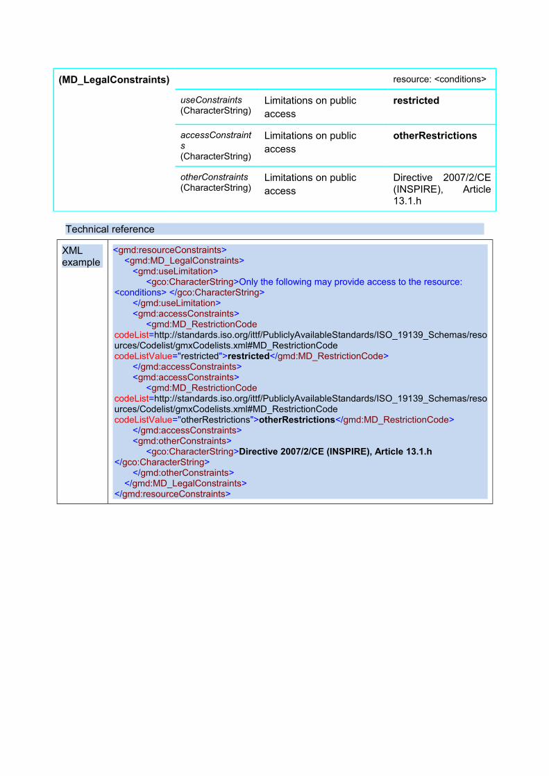
(MD_LegalConstraints) resource: <conditions>
useConstraints (CharacterString)
Limitations on public access
restricted
accessConstraints (CharacterString)
Limitations on public access
otherRestrictions
otherConstraints (CharacterString)
Limitations on public access
Directive 2007/2/CE (INSPIRE), Article 13.1.h
Technical reference
XML example
<gmd:resourceConstraints><gmd:MD_LegalConstraints>
<gmd:useLimitation><gco:CharacterString>Only the following may provide access to the resource:
<conditions> </gco:CharacterString></gmd:useLimitation><gmd:accessConstraints>
<gmd:MD_RestrictionCode codeList=http://standards.iso.org/ittf/PubliclyAvailableStandards/ISO_19139_Schemas/resources/Codelist/gmxCodelists.xml#MD_RestrictionCode codeListValue="restricted">restricted</gmd:MD_RestrictionCode>
</gmd:accessConstraints><gmd:accessConstraints>
<gmd:MD_RestrictionCode codeList=http://standards.iso.org/ittf/PubliclyAvailableStandards/ISO_19139_Schemas/resources/Codelist/gmxCodelists.xml#MD_RestrictionCode codeListValue="otherRestrictions">otherRestrictions</gmd:MD_RestrictionCode>
</gmd:accessConstraints><gmd:otherConstraints>
<gco:CharacterString>Directive 2007/2/CE (INSPIRE), Article 13.1.h </gco:CharacterString>
</gmd:otherConstraints></gmd:MD_LegalConstraints>
</gmd:resourceConstraints>
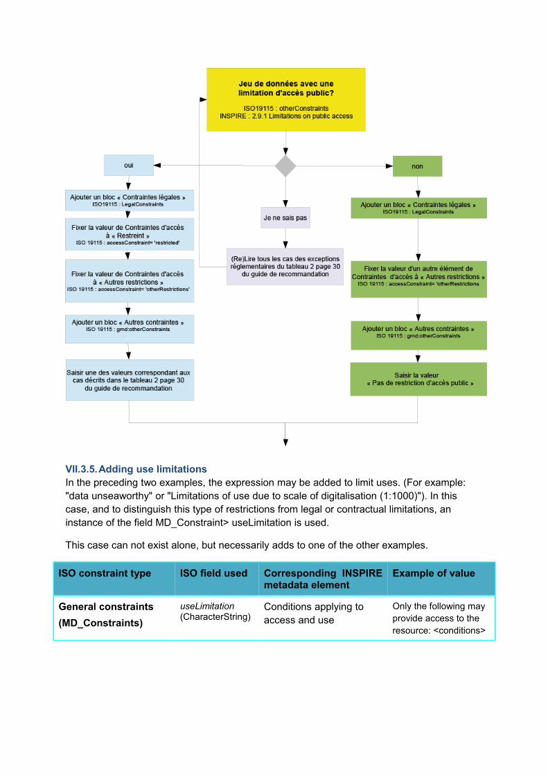
VII.3.5.Adding use limitations In the preceding two examples, the expression may be added to limit uses. (For example: "data unseaworthy" or "Limitations of use due to scale of digitalisation (1:1000)"). In this case, and to distinguish this type of restrictions from legal or contractual limitations, an instance of the field MD_Constraint> useLimitation is used.
This case can not exist alone, but necessarily adds to one of the other examples.
ISO constraint type ISO field used Corresponding INSPIRE metadata element
Example of value
General constraints
(MD_Constraints)
useLimitation (CharacterString)
Conditions applying to access and use
Only the following may provide access to the resource: <conditions>
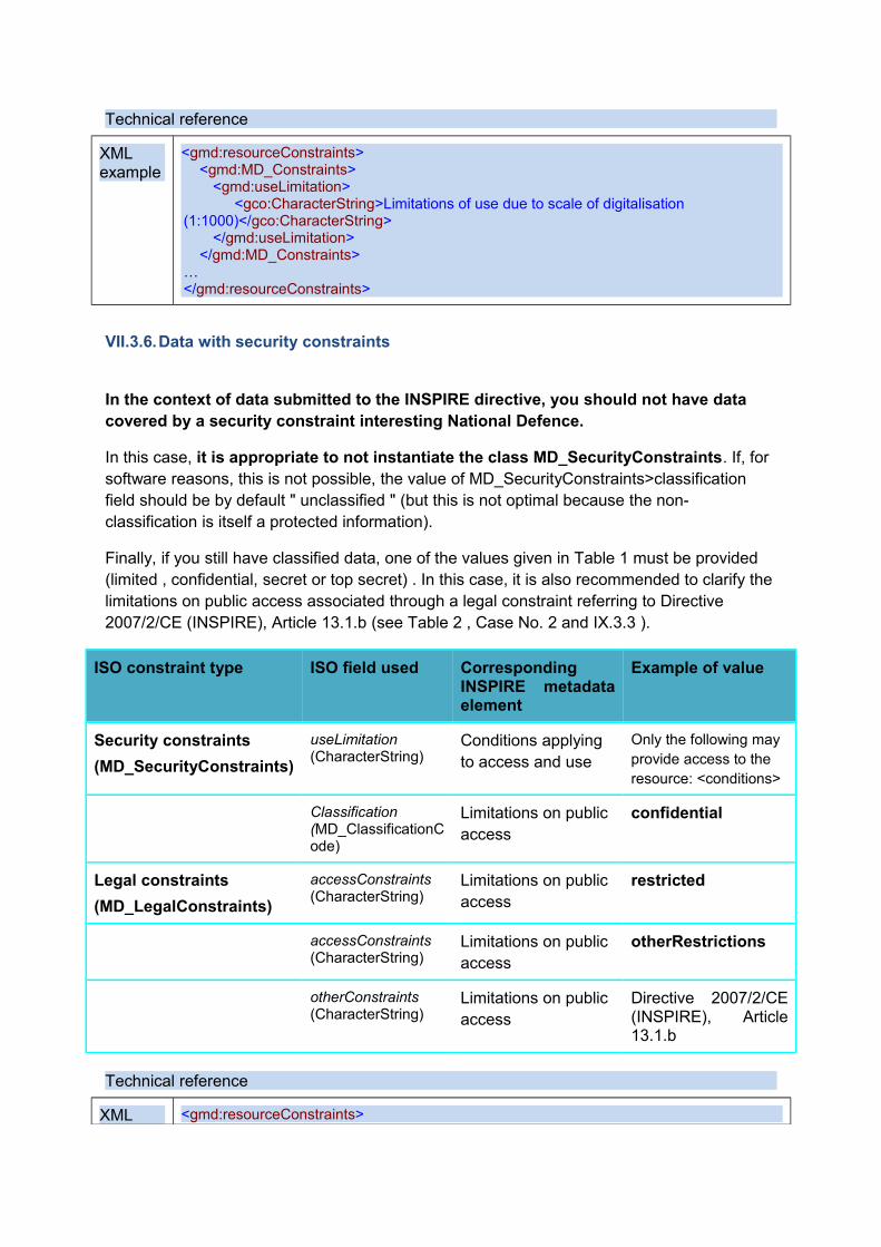
Technical reference
XML example
<gmd:resourceConstraints><gmd:MD_Constraints>
<gmd:useLimitation><gco:CharacterString>Limitations of use due to scale of digitalisation
(1:1000)</gco:CharacterString></gmd:useLimitation>
</gmd:MD_Constraints>…</gmd:resourceConstraints>
VII.3.6.Data with security constraints
In the context of data submitted to the INSPIRE directive, you should not have data covered by a security constraint interesting National Defence.
In this case, it is appropriate to not instantiate the class MD_SecurityConstraints. If, for software reasons, this is not possible, the value of MD_SecurityConstraints>classification field should be by default " unclassified " (but this is not optimal because the non-classification is itself a protected information).
Finally, if you still have classified data, one of the values given in Table 1 must be provided (limited , confidential, secret or top secret) . In this case, it is also recommended to clarify the limitations on public access associated through a legal constraint referring to Directive 2007/2/CE (INSPIRE), Article 13.1.b (see Table 2 , Case No. 2 and IX.3.3 ).
ISO constraint type ISO field used Corresponding INSPIRE metadata element
Example of value
Security constraints
(MD_SecurityConstraints)
useLimitation (CharacterString)
Conditions applying to access and use
Only the following may provide access to the resource: <conditions>
Classification (MD_ClassificationCode)
Limitations on public access
confidential
Legal constraints
(MD_LegalConstraints)
accessConstraints (CharacterString)
Limitations on public access
restricted
accessConstraints (CharacterString)
Limitations on public access
otherRestrictions
otherConstraints (CharacterString)
Limitations on public access
Directive 2007/2/CE (INSPIRE), Article 13.1.b
Technical reference
XML <gmd:resourceConstraints>
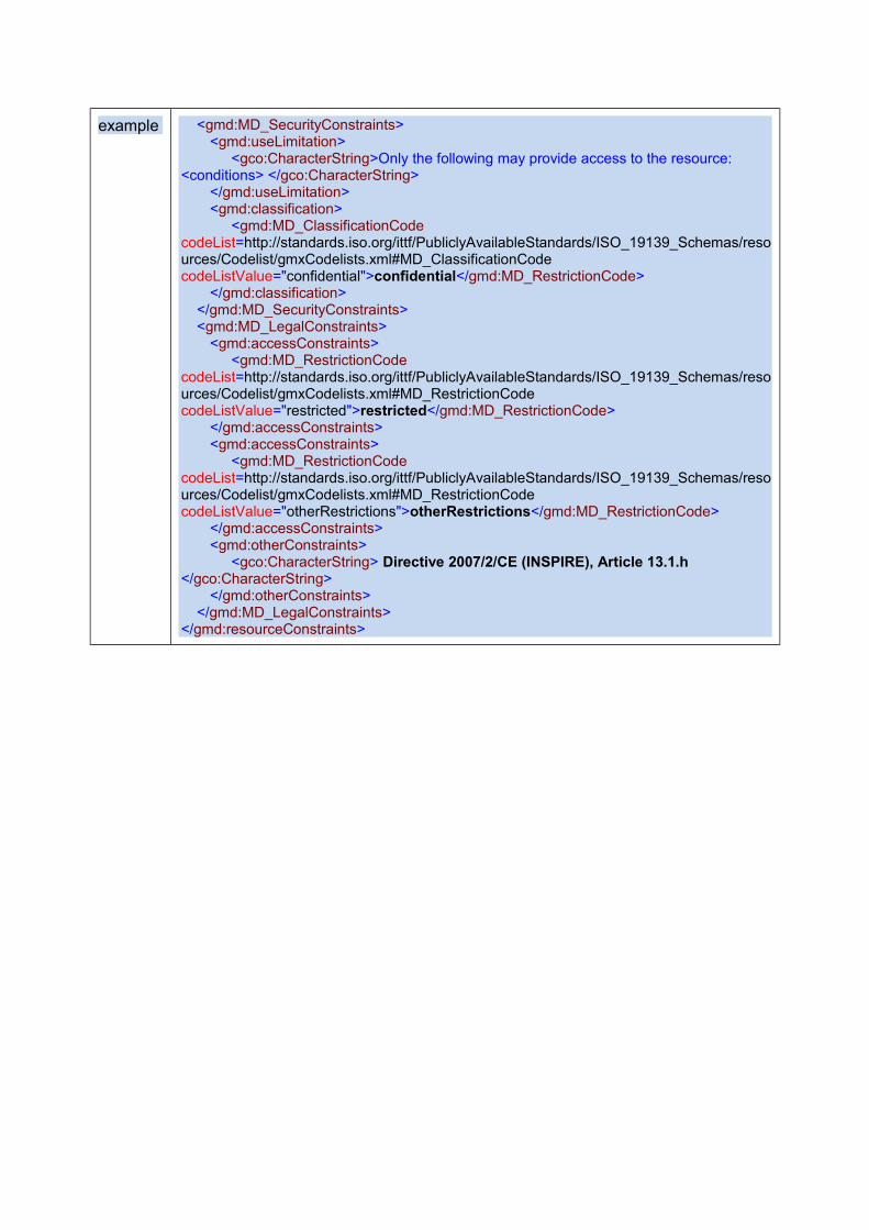
example <gmd:MD_SecurityConstraints><gmd:useLimitation>
<gco:CharacterString>Only the following may provide access to the resource: <conditions> </gco:CharacterString>
</gmd:useLimitation><gmd:classification>
<gmd:MD_ClassificationCode codeList=http://standards.iso.org/ittf/PubliclyAvailableStandards/ISO_19139_Schemas/resources/Codelist/gmxCodelists.xml#MD_ClassificationCode codeListValue="confidential">confidential</gmd:MD_RestrictionCode>
</gmd:classification></gmd:MD_SecurityConstraints><gmd:MD_LegalConstraints>
<gmd:accessConstraints><gmd:MD_RestrictionCode
codeList=http://standards.iso.org/ittf/PubliclyAvailableStandards/ISO_19139_Schemas/resources/Codelist/gmxCodelists.xml#MD_RestrictionCode codeListValue="restricted">restricted</gmd:MD_RestrictionCode>
</gmd:accessConstraints><gmd:accessConstraints>
<gmd:MD_RestrictionCode codeList=http://standards.iso.org/ittf/PubliclyAvailableStandards/ISO_19139_Schemas/resources/Codelist/gmxCodelists.xml#MD_RestrictionCode codeListValue="otherRestrictions">otherRestrictions</gmd:MD_RestrictionCode>
</gmd:accessConstraints><gmd:otherConstraints>
<gco:CharacterString> Directive 2007/2/CE (INSPIRE), Article 13.1.h </gco:CharacterString>
</gmd:otherConstraints></gmd:MD_LegalConstraints>
</gmd:resourceConstraints>
VIII. Organisation responsible for the establishment, management, maintenance and distribution of spatial data sets and services
INSPIRE REQUIREMENTS :
• Several responsible organizations can be identified for a resource. For each of them, the two following metadata elements must be completed.
VIII.1. Responsible party
INSPIRE REQUIREMENTS :
This is the description of the organisation responsible for the establishment, management, maintenance and distribution of the resource.
This description shall include the name of the organisation as free text and a contact e-mail address as a character string.
Comments:
Where a responsible party has several roles, the two metadata items shall be repeated for each role.
NATIONAL RECOMMENDATIONS :
1. It is not recommended to provide an nominative e-mail address, in order to more easily manage the changes in the functions of those involved.
2. Too generic Addresses (as "[email protected]" are also to be avoided.
3. The name of the responsible party must be the full legal and updated name. The hyphens should be retained.
Examples: Prefecture of Paris, Directorate of Urban Planning, Housing and Equipment Email: [email protected] Departmental Directorate for Territories and Sea of Bouches-du-Rhône General Council of the Alpes-Maritimes
Cons-examples:
DDT 13, DDTM 13, DDTM_13, DDTM13
CG06, CG 06, CG_06
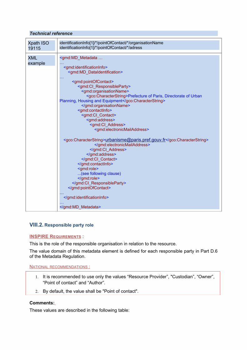
Technical reference
Xpath ISO 19115
identificationInfo[1]/*/pointOfContact/*/organisationNameidentificationInfo[1]/*/pointOfContact/*/adress
XML example
<gmd:MD_Metadata ……
<gmd:identificationInfo><gmd:MD_DataIdentification>
…<gmd:pointOfContact>
<gmd:CI_ResponsibleParty><gmd:organisationName>
<gco:CharacterString>Prefecture of Paris, Directorate of Urban Planning, Housing and Equipment</gco:CharacterString>
</gmd:organisationName><gmd:contactInfo>
<gmd:CI_Contact><gmd:address>
<gmd:CI_Address><gmd:electronicMailAddress>
<gco:CharacterString>[email protected]</gco:CharacterString></gmd:electronicMailAddress>
</gmd:CI_Address></gmd:address>
</gmd:CI_Contact></gmd:contactInfo><gmd:role>...(see following clause)</gmd:role>
</gmd:CI_ResponsibleParty></gmd:pointOfContact>
…</gmd:identificationInfo>
…</gmd:MD_Metadata>
VIII.2. Responsible party role
INSPIRE REQUIREMENTS :
This is the role of the responsible organisation in relation to the resource.
The value domain of this metadata element is defined for each responsible party in Part D.6 of the Metadata Regulation.
NATIONAL RECOMMENDATIONS :
1. It is recommended to use only the values “Resource Provider”, "Custodian”, “Owner”, “Point of contact” and “Author”.
2. By default, the value shall be "Point of contact".
Comments:
These values are described in the following table:
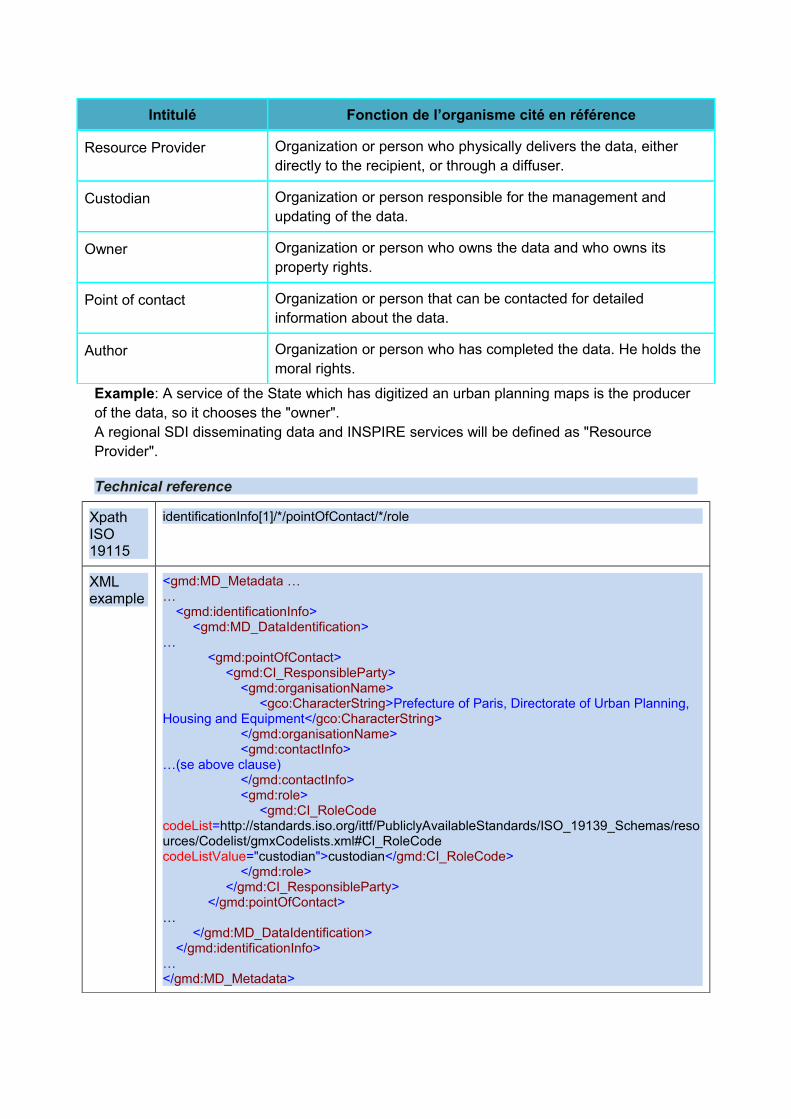
Intitulé Fonction de l’organisme cité en référence
Resource Provider Organization or person who physically delivers the data, either directly to the recipient, or through a diffuser.
Custodian Organization or person responsible for the management and updating of the data.
Owner Organization or person who owns the data and who owns its property rights.
Point of contact Organization or person that can be contacted for detailed information about the data.
Author Organization or person who has completed the data. He holds the moral rights.
Example: A service of the State which has digitized an urban planning maps is the producer of the data, so it chooses the "owner". A regional SDI disseminating data and INSPIRE services will be defined as "Resource Provider".
Technical reference
Xpath ISO 19115
identificationInfo[1]/*/pointOfContact/*/role
XML example
<gmd:MD_Metadata ……
<gmd:identificationInfo><gmd:MD_DataIdentification>
…<gmd:pointOfContact>
<gmd:CI_ResponsibleParty><gmd:organisationName>
<gco:CharacterString>Prefecture of Paris, Directorate of Urban Planning, Housing and Equipment</gco:CharacterString>
</gmd:organisationName><gmd:contactInfo>
…(se above clause)</gmd:contactInfo><gmd:role>
<gmd:CI_RoleCodecodeList=http://standards.iso.org/ittf/PubliclyAvailableStandards/ISO_19139_Schemas/resources/Codelist/gmxCodelists.xml#CI_RoleCode codeListValue="custodian">custodian</gmd:CI_RoleCode>
</gmd:role></gmd:CI_ResponsibleParty>
</gmd:pointOfContact>…
</gmd:MD_DataIdentification></gmd:identificationInfo>
…</gmd:MD_Metadata>
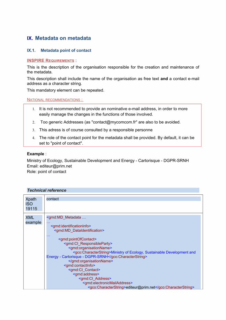
IX. Metadata on metadata
IX.1. Metadata point of contact
INSPIRE REQUIREMENTS :
This is the description of the organisation responsible for the creation and maintenance of the metadata.
This description shall include the name of the organisation as free text and a contact e-mail address as a character string.
This mandatory element can be repeated.
NATIONAL RECOMMENDATIONS :
1. It is not recommended to provide an nominative e-mail address, in order to more easily manage the changes in the functions of those involved.
2. Too generic Addresses (as "[email protected]" are also to be avoided.
3. This adress is of course consulted by a responsible personne
4. The role of the contact point for the metadata shall be provided. By default, it can be set to "point of contact".
Example :
Ministry of Ecology, Sustainable Development and Energy - Cartorisque - DGPR-SRNH Email: [email protected] Role: point of contact
Technical reference
Xpath ISO 19115
contact
XML example
<gmd:MD_Metadata ……
<gmd:identificationInfo><gmd:MD_DataIdentification>
…<gmd:pointOfContact>
<gmd:CI_ResponsibleParty><gmd:organisationName>
<gco:CharacterString>Ministry of Ecology, Sustainable Development and Energy - Cartorisque - DGPR-SRNH</gco:CharacterString>
</gmd:organisationName><gmd:contactInfo>
<gmd:CI_Contact><gmd:address>
<gmd:CI_Address><gmd:electronicMailAddress>
<gco:CharacterString>[email protected]</gco:CharacterString>
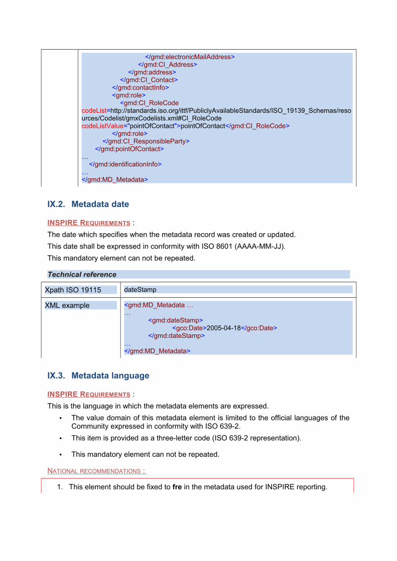
</gmd:electronicMailAddress></gmd:CI_Address>
</gmd:address></gmd:CI_Contact>
</gmd:contactInfo><gmd:role>
<gmd:CI_RoleCodecodeList=http://standards.iso.org/ittf/PubliclyAvailableStandards/ISO_19139_Schemas/resources/Codelist/gmxCodelists.xml#CI_RoleCode codeListValue="pointOfContact">pointOfContact</gmd:CI_RoleCode>
</gmd:role></gmd:CI_ResponsibleParty>
</gmd:pointOfContact>…
</gmd:identificationInfo>…</gmd:MD_Metadata>
IX.2. Metadata date
INSPIRE REQUIREMENTS :
The date which specifies when the metadata record was created or updated.
This date shall be expressed in conformity with ISO 8601 (AAAA-MM-JJ).
This mandatory element can not be repeated.
Technical reference
Xpath ISO 19115 dateStamp
XML example <gmd:MD_Metadata ……
<gmd:dateStamp><gco:Date>2005-04-18</gco:Date>
</gmd:dateStamp>…</gmd:MD_Metadata>
IX.3. Metadata language
INSPIRE REQUIREMENTS :
This is the language in which the metadata elements are expressed.
• The value domain of this metadata element is limited to the official languages of the Community expressed in conformity with ISO 639-2.
• This item is provided as a three-letter code (ISO 639-2 representation).
• This mandatory element can not be repeated.
NATIONAL RECOMMENDATIONS :
1. This element should be fixed to fre in the metadata used for INSPIRE reporting.
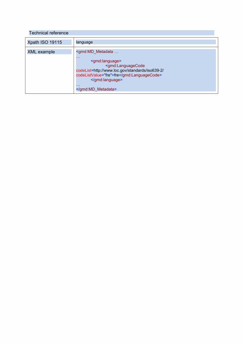
Technical reference
Xpath ISO 19115 language
XML example <gmd:MD_Metadata ……
<gmd:language><gmd:LanguageCode
codeList=http://www.loc.gov/standards/iso639-2/ codeListValue="fre">fre</gmd:LanguageCode>
</gmd:language>…</gmd:MD_Metadata>
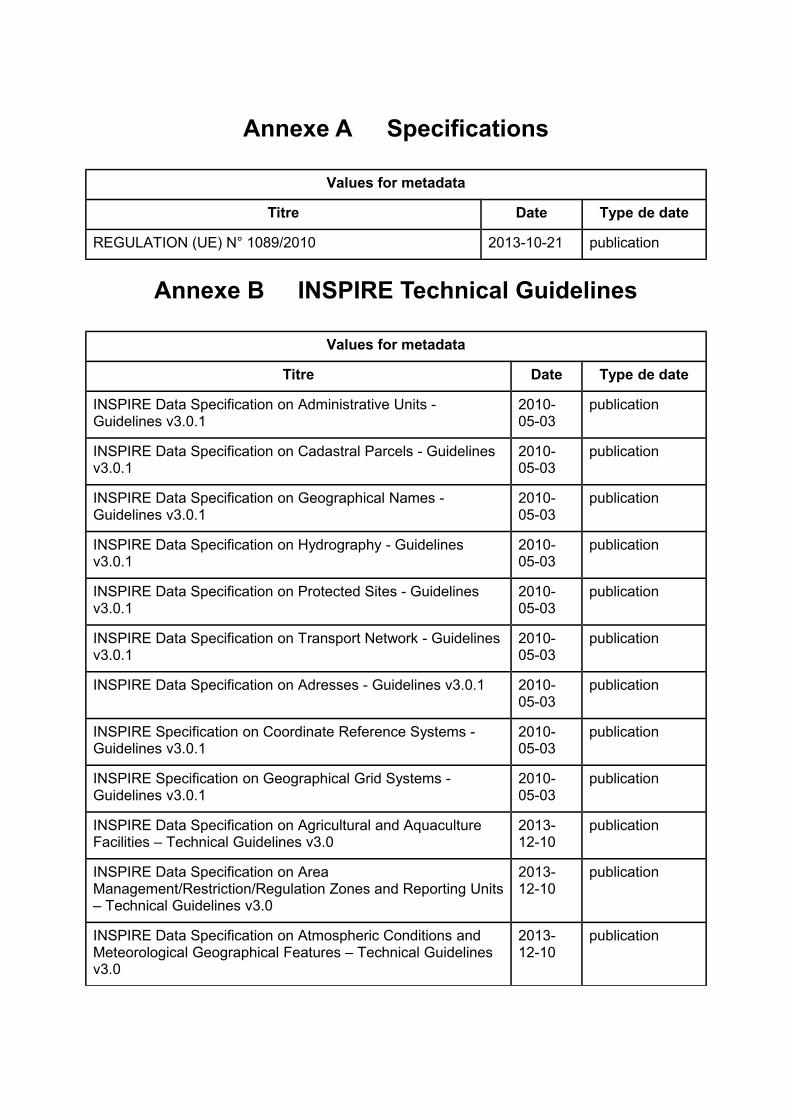
Annexe A Specifications
Values for metadata
Titre Date Type de date
REGULATION (UE) N° 1089/2010 2013-10-21 publication
Annexe B INSPIRE Technical Guidelines
Values for metadata
Titre Date Type de date
INSPIRE Data Specification on Administrative Units - Guidelines v3.0.1
2010-05-03
publication
INSPIRE Data Specification on Cadastral Parcels - Guidelines v3.0.1
2010-05-03
publication
INSPIRE Data Specification on Geographical Names - Guidelines v3.0.1
2010-05-03
publication
INSPIRE Data Specification on Hydrography - Guidelines v3.0.1
2010-05-03
publication
INSPIRE Data Specification on Protected Sites - Guidelines v3.0.1
2010-05-03
publication
INSPIRE Data Specification on Transport Network - Guidelines v3.0.1
2010-05-03
publication
INSPIRE Data Specification on Adresses - Guidelines v3.0.1 2010-05-03
publication
INSPIRE Specification on Coordinate Reference Systems - Guidelines v3.0.1
2010-05-03
publication
INSPIRE Specification on Geographical Grid Systems - Guidelines v3.0.1
2010-05-03
publication
INSPIRE Data Specification on Agricultural and Aquaculture Facilities – Technical Guidelines v3.0
2013-12-10
publication
INSPIRE Data Specification on Area Management/Restriction/Regulation Zones and Reporting Units – Technical Guidelines v3.0
2013-12-10
publication
INSPIRE Data Specification on Atmospheric Conditions and Meteorological Geographical Features – Technical Guidelines v3.0
2013-12-10
publication
Values for metadata
Titre Date Type de date
INSPIRE Data Specification on Bio-geographical Regions – Technical Guidelines v3.0
2013-12-10
publication
INSPIRE Data Specification on Buildings – Technical Guidelines v3.0
2013-12-10
publication
INSPIRE Data Specification on Elevation – Technical Guidelines v3.0
2013-12-10
publication
INSPIRE Data Specification on Energy Resources – Technical Guidelines v3.0
2013-12-10
publication
INSPIRE Data Specification on Environmental Monitoring Facilities – Technical Guidelines v3.0
2013-12-10
publication
INSPIRE Data Specification on Geology – Technical Guidelines v3.0
2013-12-10
publication
INSPIRE Data Specification on Habitats and Biotopes – Technical Guidelines v3.0
2013-12-10
publication
INSPIRE Data Specification on Human Health and Safety – Technical Guidelines v3.0
2013-12-10
publication
INSPIRE Data Specification on Land Cover – Technical Guidelines v3.0
2013-12-10
publication
INSPIRE Data Specification on Land Use – Technical Guidelines v3.0
2013-12-10
publication
INSPIRE Data Specification on Mineral Resources – Technical Guidelines v3.0
2013-12-10
publication
INSPIRE Data Specification on Natural Risk Zones – Technical Guidelines v3.0
2013-12-10
publication
INSPIRE Data Specification on Oceanographic geographical features – Technical Guidelines v3.0
2013-12-10
publication
INSPIRE Data Specification on Orthoimagery – Technical Guidelines v3.0
2013-12-10
publication
INSPIRE Data Specification on Population Distribution – Technical Guidelines v3.0
2013-12-10
publication
INSPIRE Data Specification on Production and Industrial Facilities – Technical Guidelines v3.0
2013-12-10
publication
INSPIRE Data Specification on Sea Regions – Technical Guidelines v3.0
2013-12-10
publication
INSPIRE Data Specification on Soil – Technical Guidelines v3.0
2013-12-10
publication
Values for metadata
Titre Date Type de date
INSPIRE Data Specification on Species Distribution – Technical Guidelines v3.0
2013-12-10
publication
INSPIRE Data Specification on Statistical Units – Technical Guidelines v3.0
2013-12-10
publication
INSPIRE Data Specification on Utility and Government Services – Technical Guidelines v3.0
2013-12-10
publication