Free & Open Source Extensions - Terra GIS · Free & Open Source Extensions SpatialKitand SEXTANTE...
28
Free & Open Source Extensions SpatialKit and SEXTANTE for ArcGIS Desktop 9 and 10 Karsten Vennemann, Terra GIS Ltd. www.terragis.net Seattle, WA, USA [email protected] 206 905 1711
Transcript of Free & Open Source Extensions - Terra GIS · Free & Open Source Extensions SpatialKitand SEXTANTE...

Free & Open Source Extensions
SpatialKit and SEXTANTEfor ArcGIS Desktop 9 and 10
Karsten Vennemann, Terra GIS Ltd.
www.terragis.netSeattle, WA, USA
[email protected] 905 1711

SpatialKit and SEXTANTE for ArcGIS Desktop 9 and 10
About Spatialkit
PostGISUsing Spatialkit
SpatialKit for ArcMap
SpatialKit and SEXTANTEArcGIS Desktop
About Sextante
Using Sextante
ArcGIS
gvSIG CE
SEXTANTE for Desktop GIS
Resources
Talk Overview

SpatialKit and SEXTANTE for ArcGIS Desktop 9 and 10
SpatialKit for ArcMapneeds ArcGIS ≥ 9.2 , .Net Framework ≥ 3.5, SpatialKit,PostgreSQL ≥ 8.4, PostGIS ≥ 1.5.
www.st-links.com
user manualhttp://st-links.com/Documents/STSpatialKit3.pdf
PostGIS - http://postgis.refractions.net/
Book: Obe, R.& Hsu, L.(2011): PostGIS in Action.Manning. 492 pages, www.manning.com/obe/
SpatialKit for ArcMap does notnot require ArcSDE, ArcInfo, Spatial Data Server (SDS) technology, or ArcGIS server

SpatialKit and SEXTANTE for ArcGIS Desktop 9 and 10
SpatialKit for ArcGIS

SpatialKit and SEXTANTE for ArcGIS Desktop 9 and 10
Format ConversionSpatialKit for ArcGIS

SpatialKit and SEXTANTE for ArcGIS Desktop 9 and 10
SpatialKit for ArcGIS
For the most part SpatialKit seamlessly integrates with ArcMap.
Restrictions
Tips
But !

SpatialKit and SEXTANTE for ArcGIS Desktop 9 and 10
SpatialKit for ArcGIS
use ArcGIS definition queries
Using Spatial Kit Tips
Set Map View
Extent
create spatial indexes in PostGIS
SpatialKit and SEXTANTE for ArcGIS Desktop 9 and 10
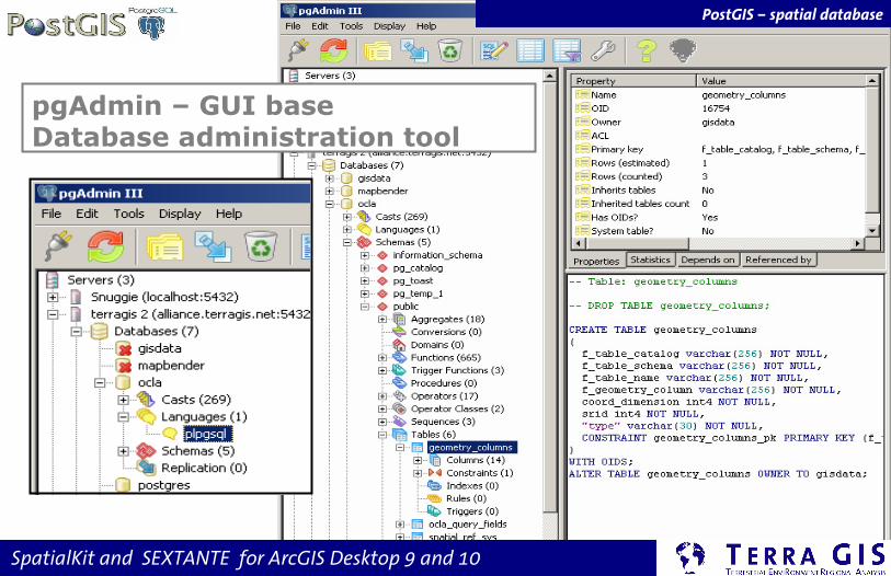
pgAdmin – GUI baseDatabase administration tool
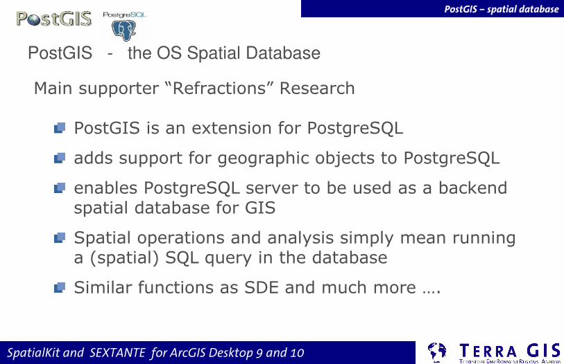
PostGIS – spatial database

SpatialKit and SEXTANTE for ArcGIS Desktop 9 and 10
PostGIS tables geometry columns
spatial reference table
PostGIS – spatial database
SpatialKit and SEXTANTE for ArcGIS Desktop 9 and 10
Main supporter “Refractions” Research
PostGIS is an extension for PostgreSQL
adds support for geographic objects to PostgreSQL
enables PostgreSQL server to be used as a backend spatial database for GIS
Spatial operations and analysis simply mean running a (spatial) SQL query in the database
Similar functions as SDE and much more ….
PostGIS - the OS Spatial Database
PostGIS – spatial database

SpatialKit and SEXTANTE for ArcGIS Desktop 9 and 10
PostGIS Examples
PostGIS Functions
Spatial SQL

SpatialKit and SEXTANTE for ArcGIS Desktop 9 and 10
More spatial operations
BufferSelect st_buffer(ST_Simplify(the_geom, 700), 9000) from wa_counties where name ilike 'King';
Intersectselect name from counties where counties.the_geom && (setsrid((MakePoint(1622794, 150532)),2285)) and intersects (counties.the_geom,setsrid((MakePoint(1622794, 150532)),2285));
PostGIS Examples

SpatialKit and SEXTANTE for ArcGIS Desktop 9 and 10
Schematic View of the Interoperable Web GIS
Example PostGIS – in Web mapping
Web browser
Web Server (EC2)Servers
Client Side Scripting (JavaScript/AJAX)
WMS
Client Side Framework:OpenLayers
Client
Vector
filese.g.
precinctsshapefiles
Spatial
DB:PostGISe.g.
geocoded voters
Mapping Engine:MapServer
tiled images
e.g. GoogleYahoo
MS Virtual Earth
local
Spatial Data
commercial layers
API
Web Servers
Spatial Data

SpatialKit and SEXTANTE for ArcGIS Desktop 9 and 10
Simple spatial operations
Output formatselect askml(the_geom) from counties2008 where name ilike ‘king’;
Human readable geometryselect astext(the_geom) from counties where name ilike 'King';
Distanceselect distance(setsrid((MakePoint(1622794, 150532)),2285),setsrid((MakePoint(1622845, 150937)),2285));
TransformSelect transform((setsrid(MakePoint(1622794, 150532),2285)),4326);
PostGIS Examples

SpatialKit and SEXTANTE for ArcGIS Desktop 9 and 10
Aggregate functions - Union of polygons
Union all counties of the county polygon data set "us_counties " to create one polygon encompassing the area of the entire US.
select st_union(the_geom)into us_borderfrom us_counties
This operation unions all individual datasets and groups them by states.
select st_union (the_geom), state_nameinto us_statesfrom us_countiesgroup by state_name;
PostGIS Examples

SpatialKit and SEXTANTE for ArcGIS Desktop 9 and 10
SEXTANTE for ArcGISneeds: ArcGIS ≥ 9.3.1, Java, ArcDesktop Java SDK - included with
ArcView version 10, at version 9.3.1 separate purchase as ArcEngine
SEXTANTE for ArcGIS
www.sextantegis.com
user manual http://www.unex.es/eweb/sextantegis/IntroductionToSEXTANTE.pdf
http://www.sextantegis.com/arcgis.html
Sextante Articles
Beta !

SpatialKit and SEXTANTE for ArcGIS Desktop 9 and 10
SEXTANTE Web page
Sextante
625algorithms !

SpatialKit and SEXTANTE for ArcGIS Desktop 9 and 10
Installation SEXTANTE For ArcGIS
extract to arcgispath\java\lib\ext
Sextante

SpatialKit and SEXTANTE for ArcGIS Desktop 9 and 10
Sextante
Functionality
provides tools & toolbox
native algorithms
access to other libraries SAGA, Grass and R
Model Builder
Batch processing
Programming environment
Command Line tools

SpatialKit and SEXTANTE for ArcGIS Desktop 9 and 10
Restrictions - early release (Beta) Sextante in ArcGIS
Sextante
limitations –geoprocessing environment - parameter "Use only selected
features“
Output formats: tif, shape, dbf
Extent - SEXTANTE algorithms do not honor the "Processing Extent" setting
File overwriting - can cause unpredicted results
Geometries - Polygons with holes cannot be created yet by SEXTANTE
Model Builder - Certain algorithms will not work properly on the algorithm, due to
differences between the semantics of SEXTANTE algorithms and ArcGIS tools.
ESRI Document: How to troubleshoot ArcGIS Java Extensions

SpatialKit and SEXTANTE for ArcGIS Desktop 9 and 10
SEXTANTEToolbox
Sextante

SpatialKit and SEXTANTE for ArcGIS Desktop 9 and 10
Project of the Spanish province of Extremadura
Sistema Extremeno de Analisis Territorial
Geo-processing tool set - software library
more than 280 spatial functions raster and vector processingoriginally targeted at forestry usage, initially based on SAGA GIS
Java based plug-ins for Desktop GIS
gvSIG and OpenJUMP 1.3
ArcGIS 9.3.1 and 10.X
Sextante

SpatialKit and SEXTANTE for ArcGIS Desktop 9 and 10
project - Spanish Community of Valencia
mid range Desktop GIS
based on open standards
part of gvPONTIS projecthttp://www.gvpontis.gva.es/fileadmin/conselleria/images/Documentacion/memoria/gvpontis_ingles.pdf
gvSIG – Generalidad ValencianaConselleria d'Infraestructures i Transport

SpatialKit and SEXTANTE for ArcGIS Desktop 9 and 10
gvSIG and Sextante facts
gvSIG Association
Sextante

SpatialKit and SEXTANTE for ArcGIS Desktop 9 and 10
based on gvSIG
Community effort
many plug-ins integrated Postgis, ArcSDE, Navtable & Sextante , Grass, SAGA
http://gvsigce.sourceforge.net/joomla/
gvSIG CE – Community Edition

SpatialKit and SEXTANTE for ArcGIS Desktop 9 and 10
Resources
Resources
Spatial Kit for ArcMap
www.st-links.com
PostGIS - http://postgis.refractions.net/
Obe, R.& Hsu, L.(2011): PostGIS in Action. Manning. 492 pages, www.manning.com/obe/
SEXTANTE
www.sextantegis.com
http://www.sextantegis.com/arcgis.html
Sextante Articles
Grass GIS http://grass.fbk.eu/ , Saga http://www.saga-gis.org/en/index.html
Download presentation http://www.terragis.net/docs/presentations

SpatialKit and SEXTANTE for ArcGIS Desktop 9 and 10
gvSIG CE (with Sextante)

SpatialKit and SEXTANTE for ArcGIS Desktop 9 and 10
Contact me with questions
Karsten Vennemann
www.terragis.netSeattle, WA, USA
[email protected] 905 1711
Terra GIS offersGIS consulting and training

![GEO 580 Lab 3 - GIS Analysis Models · GEO 580 Lab 3 - GIS Analysis Models ... [Electronic manual]. Jenness Enterprises: ArcView® Extensions. arcview_extensions.htm, ...](https://static.fdocuments.us/doc/165x107/5bba638109d3f2e2118b5e56/geo-580-lab-3-gis-analysis-models-geo-580-lab-3-gis-analysis-models-.jpg)