Foxton Park and Rail Transport Hub - citydeal-live.storage ... · 396964-MMD-BCA-XX-RP-BC-0003 Mott...
121
Foxton Park and Rail Transport Hub Strategic Outline Business Case February 2019
Transcript of Foxton Park and Rail Transport Hub - citydeal-live.storage ... · 396964-MMD-BCA-XX-RP-BC-0003 Mott...
Foxton Park and Rail Transport Hub
Strategic Outline Business Case
February 2019


396964-MMD-BCA-XX-RP-BC-0003 Mott MacDonald
Mott MacDonald 22 Station Road Cambridge CB1 2JD United Kingdom T +44 (0)1223 463500 F +44 (0)1223 461007 mottmac.com
Foxton Park and Rail Transport Hub
Strategic Outline Business Case
February 2019
Mott MacDonald Limited. Registered in England and Wales no. 1243967. Registered office: Mott MacDonald House, 8-10 Sydenham Road, Croydon CR0 2EE, United Kingdom

Mott MacDonald | Foxton Park and Rail Transport Hub Strategic Outline Business Case
396964-MMD-BCA-XX-RP-BC-0003 | February 2019
Issue and Revision Record
Revision Date Originator Checker Approver Description
1.0 19 Dec 2018 Chris Payne
Jack Gray
Katherine Gareau
Heather Clarke
Jason Saldanha Mike Salter Draft for early
client review
2.0 15 Feb 2019 Jack Gray
Katherine Gareau
Heather Clarke
Chris Payne Mike Salter Final draft
Document reference: 396964-MMD-BCA-XX-RP-BC-0003
Information class: Standard
This document is issued for the party which commissioned it and for specific purposes connected with the above-captioned project only. It should not be relied upon by any other party or used for any other purpose.
We accept no responsibility for the consequences of this document being relied upon by any other party, or being
used for any other purpose, or containing any error or omission which is due to an error or omission in data supplied to us by other parties.
This document contains confidential information and proprietary intellectual property. It should not be shown to other parties without consent from us and from the party which commissioned it.
This Re por t has be en p rep are d solely for use by t he p arty w hich c om mission ed it (the 'Client') i n co nnecti on wit h the cap tione d p roject . It s hould not be used for any oth er p urp ose. N o p erso n ot her tha n th e Client or any party who has expr essly a gre ed t er ms of relia nce wit h us (the 'Recipie nt(s )') m ay r ely on the cont ent, info rma tion or any view s exp ress ed in the R epo rt. This R epo rt is co nfide ntial and c ont ains p rop riet ary in tellect ual p rop erty and we ac cept no duty of ca re, resp onsibility or li ability t o any oth er recipi ent o f this R epo rt. N o re pre sent ation , wa rran ty o r un dert aking , exp ress or i mplie d, is made an d no res ponsi bility or liability is acce pted by us to any p arty oth er t han the Cli ent or a ny Reci pient (s), as t o the accu racy or c om plete ness of th e info rm ation cont aine d in t his Rep ort. Fo r t he av oida nce o f do ubt t his Re port do es no t in any way pu rpo rt to includ e a ny leg al, ins ura nce or fin ancial advic e or opini on.
We disclaim all a nd a ny liability whet her arisi ng in tort , con trac t or oth erwise which w e mi ght o the rwise h ave to a ny p arty othe r th an t he Clie nt o r th e Recipi ent (s), i n res pect of t his Rep ort, or any i nfor mati on c ontai ned i n it. We acce pt n o re spo nsibility fo r a ny e rro r o r o mission i n th e Rep ort w hich is due to a n e rro r or omis sion in dat a, inf or matio n o r stat em ents s upplie d to us by oth er parti es incl uding the Client (th e 'Data') . We h ave not i ndep end ently v erifi ed th e Dat a o r ot herwis e exa mine d it t o de ter mine the accu racy, com plete ness, sufficie ncy f or a ny p ur pose or f easibility for any partic ular outc om e inclu ding fi nanci al.
For ecasts pre sent ed in this d ocu ment wer e p repa red usin g th e Dat a an d th e Rep ort is de pend ent or base d on the Data. Ine vitably, som e of the assu mptio ns us ed t o de velop the for ecasts will not be realis ed a nd u nan ticipat ed ev ents and circu msta nces may occu r. Co nseq uently , we do n ot g uar ante e o r war ran t th e con clusions con taine d in t he R epo rt as the re a re lik ely to be di ffer ences betw een the for ecasts an d the actu al r esults and thos e diff ere nces may be mate rial. W hile we c onsid er t hat t he i nfor mati on a nd o pinio ns give n in this Re port ar e so und a ll partie s mu st r ely on thei r own skill an d jud gem ent w hen maki ng u se of it.
Infor mati on a nd o pinio ns ar e cu rre nt o nly as of t he d ate of th e Re port and we a ccept no resp onsibility for up datin g suc h info rm ation or opinio n. It sho uld, t her efo re, n ot b e ass ume d th at a ny suc h inf orm ation or opini on co ntin ues t o be accu rate subs equ ent t o th e d ate of th e Rep ort. Und er no cir cums tanc es m ay this R epo rt o r a ny ext ract or s um mar y the re of be use d in c onn ection with a ny p ublic o r p rivate secu rities offe ring i ncludin g a ny r elate d me mo ran dum or pro spect us fo r a ny sec urities off ering or stock exch ange listing or ann ounc eme nt.
By accept ance of t his Rep ort you agr ee t o be bou nd by this disclai mer. This disclai mer and any is sues, disp utes or clai ms a rising out of o r in c onn ection with it (whe the r co ntrac tual or non -cont ract ual in nat ure such as clai ms in tort , fr om b re ach o f stat ute or reg ulatio n or oth erwise ) sh all be gove rne d by , an d con stru ed in acco rda nce wit h, t he laws of En gland an d Wales to t he excl usion of all conflict of law s pri nciples and rul es. All disp utes or cl aims arising out of or r elatin g to this di sclaim er sh all be subj ect to the exclusiv e juris dictio n of t he En glish a nd W elsh co urts t o whic h th e pa rties i rrev ocably sub mit.
Conten ts

Mott MacDonald | Foxton Park and Rail Transport Hub Strategic Outline Business Case
396964-MMD-BCA-XX-RP-BC-0003 | February 2019
Executive summary 1
1 Introduction 7
1.1 Context 7
1.1.1 Cambridge Phenomenon 7
1.1.2 Greater Cambridge City Deal 7
1.1.3 Future Development 8
1.2 Scope of this Strategic Outline Business Case 10
1.3 The Scheme 11
1.4 Geographic Scope 12
1.5 Document Structure 12
2 Strategic Case 13
2.1 Business Strategy 13
2.2 The Case for Change 14
2.2.1 Strategic Economic Case 14
2.2.2 Transport Issues and Opportunities 25
2.3 Policy Context 38
2.3.1 Policy Review 38
2.3.2 Emerging Policy 41
2.3.3 Summary 42
2.4 Underlying Drivers – The Need for Intervention 43
2.5 Scheme Objectives 44
2.5.1 Scheme Objectives 45
2.6 Measures for Success 46
2.7 Options Assessment 48
2.7.1 Method Overview 48
2.7.2 Options Development 52
2.7.3 Step 1: Strategic Corridor Options Assessment 52
2.7.4 Step 2: Location Specific Options Assessment 55
2.7.5 Summary 64
2.8 Options Short List 64
2.9 Strategic Influences 64
2.9.1 Constraints 65
2.9.2 Interdependencies with Other Schemes 65
2.9.3 Pedestrian Access to Station 66
2.10 Stakeholder Engagement 67
2.10.1 Stakeholder Engagement Process 67
2.10.2 Results of Stakeholder Engagement to Date 68
2.11 Strategic Case Summary 69
3 Economic Case 70
3.1 Overview 70
3.1.1 Assessing Value for Money 70

Mott MacDonald | Foxton Park and Rail Transport Hub Strategic Outline Business Case
396964-MMD-BCA-XX-RP-BC-0003 | February 2019
3.1.2 Options Appraised 70
3.1.3 Assumptions 73
3.2 Appraisal Summary 74
3.2.1 Economic Impacts 74
3.2.2 Environmental Impacts 77
3.2.3 Social Impacts 79
3.2.4 Impact on Public Accounts 81
3.3 Benefit Cost Ratio 82
3.3.1 Present Value Benefits 82
3.3.2 Present Value Costs 82
3.3.3 Benefit Cost Ratio 83
3.3.4 Value for Money Statement 83
3.4 Economic Case Summary 85
4 Financial Case 86
4.1 Introduction 86
4.2 Scheme Affordability 86
4.3 Scheme Costs 86
4.3.1 Investment Cost Summary 86
4.3.2 Cost Sensitivities 87
4.3.3 Ongoing Operation and Maintenance Costs 88
4.4 Budgets and Funding Sources 88
4.5 Financial Case Summary 89
5 Commercial Case 90
5.1 Introduction 90
5.2 Output-based Specification 90
5.3 Procurement Options 90
5.3.1 Design and Construction Elements 90
5.3.2 Operation and Maintenance Elements 91
5.4 Commercial Case Summary 92
6 Management Case 93
6.1 Introduction 93
6.2 Evidence of Similar Projects 93
6.3 Project Delivery Plan 94
6.3.1 Project Programme 95
6.4 Project Dependencies 96
6.5 Governance Arrangements 96
6.5.1 Governance Structure 96
6.5.2 GCP Executive Board 96
6.5.3 GCP Joint Assembly 97
6.5.4 Role of the Cambridgeshire and Peterborough Combined Authority 97
6.6 Project Management 97

Mott MacDonald | Foxton Park and Rail Transport Hub Strategic Outline Business Case
396964-MMD-BCA-XX-RP-BC-0003 | February 2019
6.6.1 Project Management Team 100
6.6.2 Decision making and change control 100
6.6.3 Project Manager Report 101
6.7 Quality Assurance 101
6.8 Stakeholder Engagement 102
6.9 Risk Management 102
6.10 Benefits Realisation Plan 104
6.11 Monitoring and Evaluation 104
6.12 Management Case Summary 105
Appendices 106
A. Options Assessment Report 107
B. Park & Ride Demand Forecasting Technical Note 108
C. Consultation Plan 109
D. Record of Stakeholder Engagement 110
E. Appraisal Summary Table 111
F. Risk Register 112

Mott MacDonald | Foxton Park and Rail Transport Hub 1 Strategic Outline Business Case
396964-MMD-BCA-XX-RP-BC-0003 | February 2019
Executive summary
Introduction
The following report presents the Strategic Outline Business Case (SOBC) for a new Park &
Ride facility between Royston and Cambridge to the southwest of Junction 11 of the M11 along
the A10.
In line with Department for Transport (DfT) guidance1, this SOBC has been developed and
structured to follow the five-case model - Strategic, Economic, Financial, Commercial, and
Management Cases.
This SOBC defines the scope of the scheme, sets out the case for change, and presents the
optioneering process through which options to address identified issues and opportunities have
been developed and appraised. The SOBC goes on to outline the costs, the initial value for
money assessment of the scheme and the governance arrangements for management and
delivery.
A key output from this SOBC is a set of short listed options that may be considered for further
development and assessment in advance of any public consultation as part of the next business
case stage - Outline Business Case (OBC) - should the Greater Cambridge Partnership take the
decision to take the scheme to this next stage in its development process.
The role of Greater Cambridge in the Cambridgeshire economy
The A10 Primary Route and the parallel Cambridge Line railway line form two major transport
links into Cambridge from the southwest. The two links serve key centres of economic activity
within Greater Cambridge; namely, the northern and southern fringes of Cambridge and
Cambridge City Centre. These areas are undergoing significant growth and are home to high-
performing high-tech, bio-tech and knowledge-based businesses. For example, the Cambridge
Biomedical Campus (CBC) and Addenbrookes Campus on the southern fringe, and Cambridge
Science Park and neighbouring innovation centres and business parks on the northern fringe of
Cambridge.
These key clusters of innovation have benefited from close association with the University of
Cambridge and generate Gross Value Added (GVA2) well in excess of national and county
averages; these sites have undoubtedly contributed to the success of the Greater Cambridge
economy.
As well as accounting for 42% of GVA in the Cambridgeshire and Peterborough region, Greater
Cambridge also makes up 41% of total employees in the region, despite comprising of only 34%
of the total population3. Greater Cambridge also has very high level of workplace wages, with an
average of £40,500 per annum (compared to £35,800 nationally)4, low levels of employment at
2.4% (in 2016) compared to 4.9% nationally and a very high level of skills in the workforce with
59% of residents qualified to Level 4+ (degree or above).
Capacity constraints threaten further growth
Despite Greater Cambridge’s ongoing success, the area, and notably the Royston to Cambridge
corridor, faces supply side threats that may constrain its economic growth.
1 Department for Transport – The Transport Business Cases – January 2013
2 Gross Added Value is the measure of value for all goods and services provided within an area.
3 Figures calculated from Population Estimates, Business Register and Employment Survey (BRES), Regional Accounts, Workforce
Jobs and Annual Population Survey (APS), all ONS.
4 ONS - Average Salary by Postcode

Mott MacDonald | Foxton Park and Rail Transport Hub 2 Strategic Outline Business Case
396964-MMD-BCA-XX-RP-BC-0003 | February 2019
At present, the A10 itself faces an increasing prevalence of disruptive highways congestion that
results in unreliable journey times for both private vehicles and bus routes. In addition, there is
limited highway capacity to accommodate further travel demand, with few attractive alternatives
to travel by car from areas to the southwest of the M11 Junction 11.
High levels of delay at key points along the Royston to Cambridge route indicate that a future
growth in trips cannot be accommodated without having a further detrimental impact on
congestion. This will impede further economic and housing growth if solutions are not provided.
Investments in Greater Cambridge’s transport infrastructure to create sustainable links between
housing and jobs will thus be critical to support the area’s advanced economy, and to contribute
to its ongoing ability to compete on an international stage.
The need to address constraints
Local planning policy is supportive of a programme of significant development of both
employment land and residential land to north of the corridor, including at the Cambridge
Southern Fringe, Cambridge City Centre and Cambridge Northern Fringe.
The key sites for these developments include the rapidly growing Cambridge Biomedical
Campus (CBC). The CBC currently employs approximately 17,250 workers and is expected to
employ 30,000 workers by 20315, making the CBC home to 15-20% of all employment within
the Cambridge City boundary6. Two major residential developments are also both under
construction, at Clay Farm (up to 2,300 homes) and Trumpington Meadows / Glebe Farm (up to
1,000 homes).
The Cambridge Northern Fringe area also includes the final major piece of brownfield land
available in Cambridge, with the proposed Cambridge Northern Fringe East development
looking to form a new urban quarter to provide a balanced mix of new communities,
employment growth and leisure facilities7. This could include 5,200 new homes (core site) and
1m sq. ft. of commercial space, leading to an estimated 7,000 new jobs8 subject to the
conclusion of the Area Action Plan process currently underway.
Furthermore, the redevelopment of adjacent sites that cover the wider northern fringe areas
have the potential to deliver additional new homes and new jobs, supported by amenities and
community facilities.
Given the scale of development and growth currently occurring in Greater Cambridge, there is a
pressing need to address existing transport constraints that are limiting levels of connectivity
from communities within Greater Cambridge and beyond; including those between Royston and
Cambridge. In particular, there is a need to improve the provision and access to fast, frequent
and reliable sustainable modes of transport to improve levels of connectivity and accommodate
future growth.
Indeed, without further investment in transport infrastructure to manage and accommodate new
travel demand through sustainable means, road-based travel is likely to increase; thus, further
exacerbating existing congestion and crowding problems which are apparent today.
5 Cambridgeshire Local Transport Plan 2011-2031 (2015).
6 Nomis official labour market statistics estimate that in 2016 there were 101,000 employee jobs within the Cambridge City area.
7 Cambridge Northern Fringe Area Action Plan
8 Cambridge City Council new release from 02/07/2018 (www.cambridge.gov.uk/news/2018/07/02/developer-named-for-major-development-in-north-east-cambridge). Note that this may be revised as the authorities further develop the AAP for the area.

Mott MacDonald | Foxton Park and Rail Transport Hub 3 Strategic Outline Business Case
396964-MMD-BCA-XX-RP-BC-0003 | February 2019
The demand for Park & Ride
Demand modelling demonstrates there is a demand for improved public transport provision
along the corridor, including significant demand for additional Park & Ride capacity. For
example, at Trumpington Park & Ride demand forecasts suggest that approximately 800-900
additional spaces would be required by 2031 to accommodate future demand.
In examining the demand for Park & Ride further southwest of Trumpington along the A10, a
series of further demand modelling tests have been carried out. Based on current demand
estimates, approximately 504 spaces would be required, with an additional 145 spaces if and
when Cambridge South Station opens, giving a total requirement of 649 spaces. Using future
forecasting estimates for 2031 (which includes Cambridge South), there could be a requirement
for 715 spaces in total.
Objectives to inform option development and assessment
A series of objectives have been agreed with GCP officers for this scheme based on a review of
evidence examining the current issues and opportunities along the Royston to Cambridge A10
corridor, that also reflect current policy and strategies.
This has informed the need for investment, with four specific objectives having been identified.
These objectives have been used to guide option selection to ensure the scheme addresses the
identified issues and opportunities.
Figure 1: Scheme Objectives9
Source: Mott MacDonald
The scheme objectives set out above are also associated with a series of measurable sub-
objectives set out in Table 1. The sub-objectives have been used to inform the assessment
criteria used to test the options and identify those which perform the best in meeting the scheme
objectives.
9 Scheme objectives developed based on the identified issues and opportunities and in conjunction with GCP.

Mott MacDonald | Foxton Park and Rail Transport Hub 4 Strategic Outline Business Case
396964-MMD-BCA-XX-RP-BC-0003 | February 2019
Table 1: Scheme Sub-Objectives
Objective Sub-Objectives
A. Maximise the potential for all journeys to be undertaken by sustainable modes of transport
A-1 To increase sustainable transport mode share for trips into the city centre, the Cambridge Northern Fringe East and Southern Fringe areas, from trips originating from the south and south west along the Royston to Cambridge route.
A-2 To increase Park & Ride capacity along the Royston to Cambridge A10 corridor directly serving key areas of employment.
A-3 To reduce journey times from Park & Ride site to key employment areas to enable public transport journeys to compete more effectively with the private car.
B. Improved overall connectivity and accessibility within Greater Cambridge to support economic growth
B-1 To increase connectivity between settlements along the Royston to Cambridge route and the city centre, and the Northern and Southern Fringe areas.
C. To accommodate future growth in trips along the Royston to Cambridge route and reduce impact on traffic levels and congestion
C-1 No significant increase in traffic flows along the A10 between Royston and the M11 Junction 11.
D. Contribute to enhanced quality of life for those living and working within Greater Cambridge
D-1 To improved quality of life within Greater Cambridge by minimising traffic impacts on the environment along the Royston to Cambridge A10 corridor.
D-2 To increase cycling and walking along the Royston to Cambridge A10 corridor.
Source: Mott MacDonald
Developing options for assessment
In line with the DfT’s Transport Appraisal Guidance (TAG) appraisal process and the GCP
assurance framework, the scheme has progressed through a series of optioneering steps to
identify and assess options that address the scheme objectives. This was undertaken through
two stages of option identification and assessment using multi-criteria analysis. The aim of the
first stage was to determine the best performing strategic location for a Park & Ride scheme
between Royston and M11 Junction 11. The option proximate to Foxton station performed best
of the 8 strategic locations. The second stage saw the identification of 10 option locations at
Foxton station. These options took into consideration the parallel level crossing bypass scheme,
which intends to divert the A10 away from the current level crossing in Foxton.
The results of the second stage of options assessment for Foxton itself resulted in four site
options, two with a level crossing bypass and two without a bypass (dependent on the
conclusions from a parallel workstream examining that scheme), being recommended for further
consideration and assessment, including public consultation, should the GCP take the
proposals forward. These options are listed below:
Without the level crossing bypass:
• Option 1 – north of Foxton train station
• Option 4a – west of Foxton train station
With the level crossing bypass:
• Option 1 – north of Foxton train station
• Option 4a – west of Foxton train station

Mott MacDonald | Foxton Park and Rail Transport Hub 5 Strategic Outline Business Case
396964-MMD-BCA-XX-RP-BC-0003 | February 2019
Costs and Benefits
All of the short-listed options are expected to bring a net economic benefit for road users, as
mode shift decisions (particularly by those making commuting journeys) will reduce traffic flows
and delay in an area where significant congestion is experienced, and users benefit from overall
travel time savings compared to continuing to use their cars.
A high-level assessment of the short-listed options is provided, under the standard WebTAG
economic, environmental, and social impact headings, using information from the multi-criteria
analysis and demand modelling. A summary of the results is presented in an Appraisal
Summary Table.
The costs for the options were also calculated, and range between £4.56 million and £5.89
million. As is normal at this stage of the business case process, these are based on unit rates
and approximate quantities including basic construction costs, including land costs, overheads,
prelims and on cost provisions and will require further refinement should the scheme be taken
forward to the next stage of the business case process. It is expected that the scheme will
primarily be funded through the Greater Cambridge City Deal.
Using the outputs from the demand modelling and the scheme costs, a Benefit to Cost Ratio
(BCR) for each short-listed option was also calculated. This showed that the scheme options
offer a BCR between 2.0 and 2.6. Therefore, all scheme options are designated ‘High Value for
Money’ based on the DfT’s categorisation. The highest scoring option was Option 4a (without
bypass) with 2.6, whilst the highest scoring option with the bypass was also Option 4a (with
bypass) with 2.1. Hence, Option 4a marginally offers the highest value for money regardless of
whether the level crossing bypass is implemented.
Commercial and Management cases
At this stage in the development of the business case for this scheme it is sufficient to note that
there are a variety of routes through which the eventual solution could and would be procured.
Park & Ride site works are likely to be procured in at least three parts – scheme design, main
site works, and works outside the site boundary. However, separate procurement exercises may
be required for Park & Ride site operation and site maintenance. The procurement process will
commence following a decision from the GCP Executive Board to proceed with a preferred
option.
The GCP have in place relevant management strategies and governance structures to
successfully deliver this scheme, with the project’s aims, management processes and resources
set out in a separate Project Management Plan (PMP) and Project Initiation Document (PID).
Conclusions
The optioneering process undertaken to date has identified that, if a new site is to be provided
along the Royston to Cambridge corridor, in parallel to the Cambridge Southwest Park & Ride
scheme, a site offering up to 715 spaces located near to Foxton station would best meet the
scheme objectives. This would accommodate current and future demand and support the
sustainable growth of the Greater Cambridge economy.
Using a range of assessment criteria that reflect the schemes objectives and high-level themes
of sustainability, environment, deliverability and congestions; the location specific options
assessment resulted in the short-listing of four option locations for a new site within the parish of
Foxton, both with and without a possible new level crossing bypass.
Based on the initial BCR calculations of the four short-listed options, the scheme offers high
value for money.

Mott MacDonald | Foxton Park and Rail Transport Hub 6 Strategic Outline Business Case
396964-MMD-BCA-XX-RP-BC-0003 | February 2019
Next steps
Should the GCP take the scheme forward for further development, it is recommended that
further work will be required to develop the short-listed options for the development of a new
Park & Ride site along the A10 corridor to the southwest of Cambridge in advance of presenting
these options to the general public and stakeholders. Based on consultation and further options
development and appraisal, an OBC would be developed and presented for a preferred option.

Mott MacDonald | Foxton Park and Rail Transport Hub 7 Strategic Outline Business Case
396964-MMD-BCA-XX-RP-BC-0003 | February 2019
1 Introduction
The first section of the report presents the Strategic Outline Business Case for a new Park &
Ride scheme along the A10 between Royston and M11 Junction 11.
1.1 Context
1.1.1 Cambridge Phenomenon
Cambridge is one of the UK’s most successful and productive cities that is home to a thriving hi-
tech and biotech industry, and acts as a hotspot for UK and regional job creation. Cambridge is
projected to be the UK’s fastest growing city in terms of Gross Value Added (GVA) in 201810,
and the tenth fastest growing city by employment. Its economic success, high quality of life and
quality of place go hand in hand to make Cambridge not only a good place to do business, but
also an attractive place for highly-skilled knowledge-intensive workers, business leaders and
their families to live.
With the University of Cambridge at its heart, the area’s scale and connectedness enables
overlapping networks to develop. This has facilitated a culture of co-operation and cross-
fertilisation between entrepreneurs and academics. Cambridge’s entrepreneurial environment
and concentration of people focused on science and engineering is attracting international
businesses to invest in the area. More than 25 of the world’s largest corporations have
established operations in Cambridge, including Amazon, Apple, HP, Illumina, Microsoft, Sanofi,
Siemens and Qualcomm. In addition, AstraZeneca has chosen to locate its global research
headquarters for 2,000 staff in the city. Cambridge has transformed from a city characterised by
a high rate of start-ups, to a place in which major companies are choosing to locate their
headquarters.
The roots of the ‘Cambridge Phenomenon’ date back to the 1960s. The Greater Cambridge
Partnership’s (GCP) vision is to now:
“Unleash a second wave of the ‘Cambridge Phenomenon’’, with the aim of ‘securing
sustainable economic growth and quality of life for the people of Cambridge and
South Cambridgeshire”11
1.1.2 Greater Cambridge City Deal
The Greater Cambridge City Deal (City Deal) was signed between government and the GCP in
2014. The City Deal is overseen by the GCP, which is the local delivery body set up to oversee
the delivery of the City Deal and to promote local economic growth and development12.
The GCP aims to enable a new wave of innovation-led growth in the Greater Cambridge area
by investing in infrastructure, housing and skills; thereby addressing housing shortages and
transport congestion network capacity problems. The GCP aim to facilitate continued growth
and engender a continuation of the “Cambridge Phenomenon”.
The City Deal funding arrangements are as follows. Firstly, an initial £100 million will be
provided in the 5 years from April 2015, split into 5 equal payments. An additional £400 million
will also be available depending on the impacts identified from the initial investments, which will
10 Irwin Mitchell (2018). UK Powerhouse Report.
11 GCP Website, https://www.greatercambridge.org.uk/
12 The GCP consists of four partners, including Cambridge City Council, Cambridgeshire County Council, South Cambridgeshire District
Council and the University of Cambridge.

Mott MacDonald | Foxton Park and Rail Transport Hub 8 Strategic Outline Business Case
396964-MMD-BCA-XX-RP-BC-0003 | February 2019
be split into two further tranches of £200 million; the second tranche will be available from April
2020, while the third will be from April 2025.
When government funding is combined with the potential of an additional £500m from local
partners such as developer contributions, a potential investment in the region of £1 billion in
local infrastructure is achievable13.
This investment fund offers funding towards proposed infrastructure to help grow and maintain
Greater Cambridge’s status as a prosperous economic area and to achieve the following
outcomes in support of economic growth:
• Accelerated delivery of 33,500 new homes
• Delivery of 44,000 new jobs
• Transport infrastructure improvements to support this housing and employment growth
while retaining the high quality of life in the region.
In order achieve these outcomes, the GCP Assurance Framework sets out four strategic
objectives that all schemes being promoted by the Greater Cambridge Partnership will be
appraised and prioritised against:
• Create and retain investment to nurture the conditions necessary to enable the potential
of Greater Cambridge to create and retain the international high-tech businesses of the
future.
• Targeted business investment supporting the Cambridge Cluster to the needs of the
Greater Cambridge economy by ensuring those decisions are informed by the needs of
businesses and other key stakeholders such as the universities.
• Improve connectivity and networks between clusters and labour markets so that the
right conditions are in place to drive further growth.
• Attract and retain skills by investing in transport and housing whilst maintaining a good
quality of life, in turn allowing a long-term increase in jobs emerging from the internationally
competitive clusters and more university spin-outs.
1.1.3 Future Development
Cambridge Southern Fringe
Rapid development is taking place within Cambridge's Southern Fringe (Figure 2) incorporating
substantial employment and residential development opportunities. Extensive development is to
take place over the 2011-2031 Local Plan period and the vision for the Southern Fringe is “to
create attractive, well-integrated, accessible and sustainable new neighbourhoods for
Cambridge”14.
Addenbrooke’s Hospital south of Cambridge is a major employment centre and renowned
teaching hospital linked to Cambridge University. The hospital is part of the rapidly growing
Cambridge Biomedical Campus that currently employs approximately 17,250 workers and is
expected to employ 30,000 workers by 203115. The Biomedical Campus is therefore expected to
be home to 15-20% of all employment within the Cambridge City boundary16.
Excellent transport provision will be required so that the highly skilled workforce and visitors are
able to travel to the CBC by sustainable means wherever possible, allowing the campus to
reach its full economic growth potential.
13 Local Plan Examination Cambridge City & South Cambridgeshire, CCC 5102 / SCDC 20801.
14 Cambridge Local Plan 2014: Proposed Submission, July 2013.
15 Cambridgeshire Local Transport Plan 2011-2031 (2015).
16 Nomis official labour market statistics estimate that in 2016 there were 101,000 employee jobs within the Cambridge City area.

Mott MacDonald | Foxton Park and Rail Transport Hub 9 Strategic Outline Business Case
396964-MMD-BCA-XX-RP-BC-0003 | February 2019
There are a number of other housing and mixed-use developments west of the Cambridge
Biomedical Campus. Two major developments, both under construction, are at Clay Farm (up to
2,300 homes) and Trumpington Meadows / Glebe Farm (up to 1,000 homes).
Figure 2: Cambridge Southern Fringe major developments
Source: Cambridge Local Plan 2018
Development in the Southern Fringe is expected to contribute to further significant economic
growth in Cambridge. Given the constrained transport network, measures will be needed to
cater for and manage demand associated with this development.
Connection to Cambridge Northern Fringe
A Park & Ride site along the Royston to Cambridge corridor could also connect commuters to
the Cambridge Northern Fringe (CNF) area of major change, located in the northeast of
Cambridge city and to the east of Cambridge Science Park (CSP) (see Figure 3 below). Here, a
rail-based scheme could connect to the CNF via Cambridge North station. The inclusion of CSP
to the west of Milton Road is also being considered in the CNF Area Action Plan (AAP).
The CNF area includes the final major piece of brownfield land available in Cambridge and is an
important growth area for Greater Cambridge. The proposed CNF development would form a
new urban quarter providing a mix of balanced new communities, employment growth and
leisure facilities17. In summary the following growth is anticipated for the site18 although this may
be revised as the authorities further develop the AAP for the area:
• 5,200 homes (core site)
• 1m sq. ft. of commercial space (circa 7,000 jobs)
Furthermore, the redevelopment of the adjacent sites that cover the wider CNF area have the
potential to deliver an estimated 2,400 additional new homes and around 40,000 new jobs,
supported by amenities and community facilities. The scale of development on the adjacent
sites is however, dependent on the relocation of the existing water recycling centre.
The existing Cambridge North station could provide access to future employment and mixed
land use developments at the proposed Cambridge Northern Fringe Development. For example,
17 Cambridge Northern Fringe Area Action Plan
18 Cambridge City Council new release from 02/07/2018 (www.cambridge.gov.uk/news/2018/07/02/developer-named-for-major-development-in-north-east-cambridge)

Mott MacDonald | Foxton Park and Rail Transport Hub 10 Strategic Outline Business Case
396964-MMD-BCA-XX-RP-BC-0003 | February 2019
existing Thameslink services provide regular connections between the three Cambridgeshire
village stations on the Kings Lynn to London Kings Cross line south of the City, and Cambridge
and Cambridge North stations.
Figure 3: Cambridge Northern Fringe major development area
Source: Cambridgeshire County Council
The Cambridge to Royston Corridor – supporting housing development
Looking further out beyond Cambridge’s Southern Fringe, future growth is also planned along
the Cambridge to Royston corridor, largely consisting of housing development in identified
villages within South Cambridgeshire, focused on the village of Melbourn, and outside of South
Cambridgeshire in Royston (see Figure 11).
1.2 Scope of this Strategic Outline Business Case
This Strategic Outline Business Case (SOBC) is for a new Park & Ride scheme between
Royston and M11 Junction, along the A10 / Cambridge rail line corridor. The purpose of an
SOBC is to set out the need for intervention, provide suggested or preferred solutions and
present evidence for a decision to be made on whether to proceed with a scheme19.
In line with Department for Transport requirements, this SOBC:
• Defines the scope of the proposed scheme;
• Makes the case for change (the Strategic Case), confirming how the scheme fits with
national, regional and local objectives;
• Outlines options and carries out an initial sift to produce an option short list;
• Presents evidence on expected impacts, stating the assumptions made (the Economic
Case), and;
• Outlines the likely costs, governance structures, delivery programme, assurance
arrangements, and key stakeholders for the scheme (in the Financial, Commercial, and
Management Cases).
19 The Transport Business Cases, Department for Transport, January 2013.
Mott MacDonald | Foxton Park and Rail Transport Hub 11 Strategic Outline Business Case
396964-MMD-BCA-XX-RP-BC-0003 | February 2019
The need for additional Park & Ride capacity along the Royston to Cambridge corridor is well
documented and identified within the Cambridgeshire Local Transport Plan (2011-2031), and
the Transport Strategy for Cambridgeshire and South Cambridgeshire (2014). At the time of
writing, the Cambridgeshire and Peterborough Combined Authority (CPCA) are in the process
of developing a new Local Transport Plan for the CA area.
In addition, the Rural Travel Hubs (RTH) Feasibility Study Report20, published on behalf of
Cambridgeshire County Council, identified the feasibility of creating a Travel Hub at Foxton
station. The RTH concept is designed as a transport interchange to provide sustainable
transport options and connections between neighbouring villages and towns, that includes car
parking provision.
In common with most SOBCs, and reflecting the early stage of scheme development, the
primary focus of this document is the Strategic Case.
A key output from this SOBC is an option short list to be considered for further assessment and
public consultation as part of the development of the next business case stage, the Outline
Business Case (OBC).
1.3 The Scheme
The proposed Park & Ride scheme between Royston and M11 Junction 11 is one of several
proposed transport schemes that aim to address the issues associated with high levels of
highway congestion along the Royston to Central Cambridge corridor. The proposed Foxton
location was identified following a process of sifting and analysis to establish where, along the
A10 corridor, a new Park & Ride scheme might best be provided. This process is documented in
the accompanying Options Assessment Report (Appendix A) and summarised in Section 2.7 of
this SOBC.
The scheme, in conjunction with the proposed Cambridge South West Park & Ride scheme and
the planned 274 space expansion of the existing Trumpington Park & Ride site, could support
further economic growth in areas accessible via the existing Cambridge and Cambridge North
stations, and at locations accessible via park and ride bus services.
The proposed scheme would comprise a new Park & Rail site located at Foxton train station,
which sits on the Cambridge to Kings Cross rail line. The car park could provide up to 715 car
parking spaces to accommodate the predicted future growth in transport demand along the
corridor (see section 2.2.2.2 for more detail on demand forecasts).
Forecasting suggests the interception of traffic to the south of M11 Junction 11 at Foxton, could
potentially reduce traffic flows heading north on the A10 south of M11 J11 by up to 18% in the
morning peak (8-9am).
This SOBC provides the rationale for a new Park & Rail scheme at Foxton and sets out a range
of options for delivering the scheme. The precise detailed nature of any Park & Rail provision
will be determined at a later stage of business case development and following public and
stakeholder consultation.
20 Cambridge County Council. (2017), Rural Travel Hubs Feasibility Study Report.

Mott MacDonald | Foxton Park and Rail Transport Hub 12 Strategic Outline Business Case
396964-MMD-BCA-XX-RP-BC-0003 | February 2019
1.4 Geographic Scope
The area under consideration for any potential scheme extends from Royston train station along
the A10 through to the existing Trumpington Park & Ride site to the east of Junction 11 of the
M11. The location context of the study corridor is shown in Figure 4.
All options considered as part of the development of this scheme (see section 2.7) are adjacent
to the Cambridge Line heavy railway line and/or the A10; both the A10 and Cambridge Line
corridors route southwest between Cambridge and Royston.
The Cambridge Line, which forms part of the Great Northern Route, runs from Cambridge
Junction on the East Coast Main Line to Shepreth Branch Junction on the West Anglia Main
Line, as shown in Figure 4. Thameslink provide a mix of Express, Fast and Stopping services
on the Cambridge Line.
The A10 forms part of the Primary Route Network, providing an important strategic highway link
between King’s Lynn and London, via Downham Market, Ely, Cambridge and Royston.
Figure 4: Transport Network
Source: Mott MacDonald
1.5 Document Structure
The remainder of this SOBC is structured around the five-case model for transport business cases:
• Section 2 presents the Strategic Case, considering the ‘case for change’, including
expected wider economic benefits, policy context, scheme objectives, discussion of options,
and key influences on the scheme.
• Section 3 sets out the Economic Case, identifying the range of economic, environmental,
social, and public accounts impacts that are expected to arise from the scheme and,
therefore, the scheme’s anticipated value for money.
• Section 4 presents the initial Financial Case, including anticipated expenditure and potential
funding sources.
• Section 5 contains a high-level outline of the Commercial Case for the scheme, including
an assessment of the current marketplace, and how the new service will be planned and
managed in accordance with relevant procurement regulations.
• Section 6 contains the Management Case, including an indicative programme, governance
structure, and outline quality, communications, and risk management strategies.

Mott MacDonald | Foxton Park and Rail Transport Hub 13 Strategic Outline Business Case
396964-MMD-BCA-XX-RP-BC-0003 | February 2019
2 Strategic Case
The purpose of the Strategic Case is to consider the need for the proposed scheme. The
chapter considers the ‘case for change’, including expected wider scheme benefits, the policy
context, scheme objectives, and scheme options in the light of the scheme objectives.
2.1 Business Strategy
The Government has indicated that it will continue investing in transport infrastructure across
the UK in support of an industrial strategy for post-Brexit Britain, which creates the right
conditions for businesses to invest for the long term. Achieving economic growth and improved
living standards are key objectives for Government21.
The 2017 Transport Investment Strategy command paper, prepared by the Department for
Transport (DfT), states that through investment the DfT will seek to:
• Create a more reliable, less congested and better-connected transport network that works
for the users who rely on it;
• Build a stronger, more balanced economy by enhancing productivity and responding to
local growth priorities, and;
• Support the creation of new housing.
The scheme under consideration in this SOBC seeks to provide a sustainable mode of transport
for onward travel to the Cambridge Northern Fringe and Cambridge Science Park, Cambridge
City Centre and, in the future, the Cambridge Southern Fringe, depending on the progression of
the proposed Cambridge South station. The provision of a sustainable mode of transport for
people who would otherwise travel the entire length of their journey by private car, is aligned
with the DfT’s Investment Strategy, because it has the potential to reduce congestion and
enhance journey time reliability along the A10 Royston to Cambridge corridor.
The Park & Ride scheme set out in this SOBC has the potential to connect major employment
sites in the Northern Fringe and Cambridge Science Park, the Southern Fringe, such as
Addenbrooke’s Hospital and the wider Biomedical Campus subject to delivery of the proposed
Cambridge South station, and the city centre, to the strategic road network and national rail
network. Investment in this area therefore responds to local growth priorities by supporting
existing business entities and encouraging future ones in Greater Cambridge’s major
employment sites.
The Greater Cambridge Partnership (GCP) is the local delivery body for a City Deal which aims
to deliver up to £1billion of investment, provide vital improvements to infrastructure, support and
accelerate the creation of 44,000 new jobs and 33,500 new homes in Greater Cambridge by
2031. The GCP is working with central government, local authorities, businesses, academia and
community members to identify and deliver potential infrastructure improvements. It envisages
the creation of greener transport networks which connect people, housing and employment
centres. The Partnership’s aims are presented on the GCP website, and aim to:
• Ease congestion and prioritise greener and active travel, making it easier for people to
travel by bus, rail, cycle or on foot to improve average journey time;
• Keep the Greater Cambridge area well connected to the regional and national transport
network, opening up opportunities by working closely with partners;
21 House of Commons Briefing Paper – Brexit and Transport

Mott MacDonald | Foxton Park and Rail Transport Hub 14 Strategic Outline Business Case
396964-MMD-BCA-XX-RP-BC-0003 | February 2019
• Reallocate limited road space in the city centre and invest in public transport (including
Park & Rail) to make greater use of the existing rail network;
• Build an extensive network of new cycleways, directly connecting people to homes, jobs,
study and opportunity, across the city and neighbouring villages;
• Help make people’s journeys and lives easier by making use of research and investing in
cutting-edge technology, and;
• Connect Cambridge with strategically important towns and cities by improving our rail
stations, supporting the creation of new ones and financing new rail links.
By investing in better and greener transport networks, the GCP will help secure future growth
with the right level of supporting infrastructure. The GCP is therefore considering new Park &
Ride provision between Royston and M11 Junction 11 along the A10 as this would align with
their transport aims and overall vision and strategy for Greater Cambridge.
2.2 The Case for Change
2.2.1 Strategic Economic Case
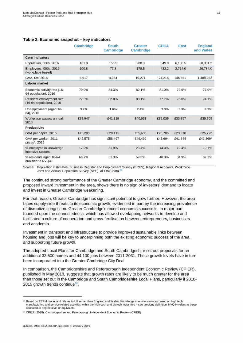
2.2.1.1 Greater Cambridge Economy
Greater Cambridge is one of the most successful and fastest growing economies in the UK,
which is driven to a large extent by its thriving high-tech and biotech industries. Regionally,
Greater Cambridge is a key driver of the Cambridgeshire and Peterborough Combined Authority
(CPCA) economy, representing22:
• 34% of the total population;
• 41% of total employees, and;
• 42% of all GVA.
In all key labour market and productivity indicators, Greater Cambridge outperforms the CPCA,
regional and national averages including:
• Very high levels of economic participation, with economic activity and employment
rates substantially higher than the comparator areas despite a high student population.
• Very low levels of unemployment, at 2.4% (in 2016) compared to 4.9% nationally. South
Cambridgeshire (alongside two other districts) has the lowest level of unemployment of all
326 districts in England (and Cambridge the 45th lowest)23.
• High levels of productivity, measured by GVA per worker, that exceed the national
average by over £6,000, driven by a very high proportion of employment within knowledge
intensive sectors, at 23.4% compared to 10.1% nationally. This is also reflected in the very
high level of workplace wages, an average of £40,500 per annum (compared to £35,800
nationally)4.
• This economic success and productivity is underpinned by the very high level of skills of
the workforce with 59% of residents qualified to Level 4+ (degree or above). Over 66% of
Cambridge residents are qualified to NVQ4 and above, making it the highest skilled city in
the UK 24.
22 Figures calculated from Population Estimates, Business Register and Employment Survey (BRES), Regional Accounts, Workforce
Jobs and Annual Population Survey (APS), all ONS.
23 Based on % of 16-64 population unemployed, using Annual Population Survey (APS), ONS, 2016
24 Cities Outlook 2017 – Centre for Cities
Mott MacDonald | Foxton Park and Rail Transport Hub 15 Strategic Outline Business Case
396964-MMD-BCA-XX-RP-BC-0003 | February 2019
Table 2: Economic snapshot – key indicators
Cambridge South Cambridge
Greater Cambridge
CPCA East England and Wales
Core indicators
Population, 000s, 2016 131.8 156.5 288.3 849.0 6,130.5 58,381.2
Employees, 000s, 2016
(workplace based)
100.8 77.8 178.5 432.2 2,714.0 26,784.0
GVA, £m, 2015 5,917 4,354 10,271 24,215 145,651 1,488,952
Labour market
Economic activity rate (16-
64 population), 2016
79.9% 84.3% 82.1% 81.0% 79.9% 77.9%
Resident employment rate
(16-64 population), 2016 77.3% 82.8% 80.1% 77.7% 76.8% 74.1%
Unemployment (aged 16-
64), 2016 3.2% 1.6% 2.4% 3.3% 3.9% 4.9%
Workplace wages, annual,
2016
£39,947 £41,119 £40,533 £35,039 £33,857 £35,808
Productivity
GVA per capita, 2015 £45,200 £28,111 £35,630 £28,786 £23,970 £25,722
GVA per worker, 2011
prices*, 2016
£42,575 £58,497 £49,499 £43,694 £41,644 £43,369*
% employed in knowledge
intensive sectors
17.0% 31.9% 23.4% 14.3% 10.4% 10.1%
% residents aged 16-64
qualified to NVQ4+
66.7% 51.3% 59.0% 40.0% 34.9% 37.7%
Source: Population Estimates, Business Register and Employment Survey (BRES), Regional Accounts, Workforce Jobs and Annual Population Survey (APS), all ONS data.25
The continued strong performance of the Greater Cambridge economy, and the committed and
proposed inward investment in the area, shows there is no sign of investors’ demand to locate
and invest in Greater Cambridge weakening.
For that reason, Greater Cambridge has significant potential to grow further. However, the area
faces supply-side threats to its economic growth, evidenced in part by the increasing prevalence
of disruptive congestion. Greater Cambridge’s recent economic success is, in major part,
founded upon the connectedness, which has allowed overlapping networks to develop and
facilitated a culture of cooperation and cross-fertilisation between entrepreneurs, businesses
and academia.
Investment in transport and infrastructure to provide improved sustainable links between
housing and jobs will be key to underpinning both the existing economic success of the area,
and supporting future growth.
The adopted Local Plans for Cambridge and South Cambridgeshire set out proposals for an
additional 33,500 homes and 44,100 jobs between 2011-2031. These growth levels have in turn
been incorporated into the Greater Cambridge City Deal.
In comparison, the Cambridgeshire and Peterborough Independent Economic Review (CPIER),
published in May 2018, suggests that growth rates are likely to be much greater for the area
than those set out in the Cambridge and South Cambridgeshire Local Plans, particularly if 2010-
2015 growth trends continue26.
25 Based on EEFM model and relates to UK rather than England and Wales. Knowledge intensive services based on high tech
manufacturing and service related activities within the high-tech and biotech industries – see previous definition. NVQ4+ refers to those
educated to degree level or equivalent.
26 CPIER (2018). Cambridgeshire and Peterborough Independent Economic Review (CPIER)

Mott MacDonald | Foxton Park and Rail Transport Hub 16 Strategic Outline Business Case
396964-MMD-BCA-XX-RP-BC-0003 | February 2019
The different employment projection scenarios, based on the different projected growth rates,
are set out in Figure 5.
Figure 5: Employment projections for Cambridgeshire and Peterborough – 000’s of people – Actual and Projected
Source: Cambridge and Peterborough Independent Economic Review (CPIER), Interim Report, May 2018
The Local Plans which set out the development strategy for Cambridge and South
Cambridgeshire, show that rapid growth is planned for Cambridge’s Southern Fringe, including
the Cambridge Biomedical Campus (CBC), significantly increasing the area’s employment
opportunities. The number of people working at the CBC is expected to increase by more than
50% by 2031. Likewise, significant growth is planned at the CNF adjacent to the Cambridge
Science Park including up to 7,000 new jobs
Greater Cambridge is, however, already facing negative impacts of its success, with house
prices increasing faster than wages, thereby pushing more people out of the city towards
surrounding towns and villages. However, Cambridge saw an annual fall of 0.6 per cent in
house prices in 2018, anecdotally linked to uncertainties surrounding Brexit27. The ambitious
economic growth proposals are also adding extra pressures to the already constrained transport
infrastructure, which suffers regular peak time congestion on key corridors and commuter routes
into and out of the city.
Investment in infrastructure and the provision of additional and affordable housing will play an
important role in supporting Cambridge’s anticipated growth and ensuring that the spatial
development strategy can succeed, thereby enabling the continued growth of fringe sites such
as CBC and CNF.
Any proposals for a new Park & Rail scheme along the Cambridge to Royston route, following
the A10 and Cambridge rail line, has the potential, in combination with the proposed Cambridge
South station, to serve the new developments on Cambridge’s Southern Fringe as well as other
opportunities accessible via the existing Cambridge and Cambridge North stations.
27 Land Registry Data, 2018-01 to 2018-12

Mott MacDonald | Foxton Park and Rail Transport Hub 17 Strategic Outline Business Case
396964-MMD-BCA-XX-RP-BC-0003 | February 2019
Any proposed Park & Ride or Park & Rail scheme could also intercept vehicular traffic on the
A10 by improving accessibility and connectivity between towns and villages to the southwest of
the city with jobs in the city centre, Cambridge Science Park (via Cambridge North Station) and
Southern Fringe (subject to delivery of the proposed Cambridge South station) developments.
2.2.1.2 Cambridge and South Cambridgeshire Local Plans – spatial development strategy
The adopted Local Plans (2018) set out the development strategies for Cambridge and South
Cambridgeshire. The two planning authorities have adopted a joint approach to spatial planning
given the well-established interdependencies between the two in terms of the location of key
employment sites, travel to work patterns and access to services and facilities. Across both
Local Plans, the overarching spatial development strategy follows a similar preferred sequence,
which can be summarised as:
1. Being within the existing urban area of Cambridge;
2. Being within the defined fringe sites on the edge of Cambridge;
3. Within the six small-scale Green Belt site proposed to be released from the inner Green Belt
boundary;
4. Within existing and newly identified new settlement locations at Cambourne, Northstowe,
Bourn Airfield and Waterbeach, and;
5. In identified villages.
Figure 6 provides a comprehensive map of the key development sites categorised into six key
areas including New Settlements, North West Cambridge and West Cambridge, Cambridge
Southern Fringe and Biomedical Campus, Cambridge Northern Fringe, City Centre
developments and existing employment locations. The GCP City Deal transport schemes are
overlaid on the map for reference.
Figure 6: Map of key developments and GCP City Deal schemes
Source: Strategic Economic Appraisal of A428-A1303 Bus Scheme, Mott MacDonald, August 2016.
Clearly, a Park & Rail transport hub along the A10 will not only support access into Cambridge
city centre by rail, but also the very high levels of development anticipated to occur within the

Mott MacDonald | Foxton Park and Rail Transport Hub 18 Strategic Outline Business Case
396964-MMD-BCA-XX-RP-BC-0003 | February 2019
Cambridge Southern Fringe (assuming delivery of the proposed Cambridge South station) and
Cambridge Northern Fringe (CNF) areas.
2.2.1.3 The Role of Market Towns, Rural Centres and Villages
Given its role as a key economic and employment centre, it is unsurprising that Cambridge lies
at the heart of a broad commuter belt and experiences high levels of net-in commuting. It’s area
of influence encompasses most of Cambridgeshire and parts of West Suffolk, Bedfordshire,
Essex and North Hertfordshire28. As shown in Figure 7, there is a very high level of in-
commuting from surrounding South Cambridgeshire including established flows along the A10
and Cambridge-King’s Cross rail line, along which villages such as Foxton are located.
Figure 7: Cambridge Travel to Work Map
Source: Travel to Work Census data 2011
The Cambridge labour market is itself impacted by the city’s own success and continued
economic growth. Cambridge’s high house prices and high rental rates have made it more
difficult for people to buy or rent in the city, and are thereby pushing more commuters into
villages and market towns in South Cambridgeshire and beyond29. Whilst South Cambridgeshire
is a largely rural district (as shown in Figure 8), it’s rural centres and villages play an important
role in supporting the Greater Cambridge economy and labour market.
28 Cambridge City Council, Cambridge Local Plan 2014 – Draft for Submission, July 2013
29 GCP, Greater Cambridge CaMKOx Firsts/last Mile Strategy, September 2017

Mott MacDonald | Foxton Park and Rail Transport Hub 19 Strategic Outline Business Case
396964-MMD-BCA-XX-RP-BC-0003 | February 2019
Figure 8: Population density in Cambridge and surround districts
Source: Population Estimates, ONS, 2016
Routes into Cambridge have been mapped into seven radial corridors that connect Cambridge
to the surrounding towns and villages in South Cambridgeshire30. The GCP describes
Cambridge’s orientation ‘like a hub and spoke network’31, with the city of Cambridge as the hub
and the seven corridors as the spokes (Figure 5). The seven corridors identified are:
• Ely and Waterbeach to Cambridge;
• Newmarket to Cambridge;
• Haverhill to Cambridge;
• Saffron Walden to Cambridge;
• Royston to Cambridge;
• St Neots and Cambourne to Cambridge, and;
• Alconbury, Huntingdon, St Ives and Northstowe to Cambridge.
30 Cambridgeshire County Council, Transport Strategy for Cambridge and South Cambridgeshire, March 2014
31 GCP, Greater Cambridge CaMKOx Firsts/last Mile Strategy, September 2017

Mott MacDonald | Foxton Park and Rail Transport Hub 20 Strategic Outline Business Case
396964-MMD-BCA-XX-RP-BC-0003 | February 2019
Figure 9: Greater Cambridge seven radial corridors (‘spokes’)
Source: GCP, Greater Cambridge CamMKOx Firsts/last Mile Strategy, September 2017
The proposed scheme falls within the Southwest Royston–Cambridge corridor. Like much of
South Cambridgeshire, the corridor has a relatively low population density, interspersed with
towns and villages such as Melbourn and Royston.
Whilst geographically Royston falls within North Hertfordshire, its economy is influenced by both
the Hertfordshire and Cambridgeshire economies, with Cambridge providing a key centre for
employment, primary healthcare, and retail32 33. Conversely, Royston itself also provides an
important service role for villages in South Cambridgeshire and North Hertfordshire, toward the
southern end of the corridor.
2.2.1.4 Spatial analysis
Connection to Cambridge Southern Fringe
A rail-based Park & Ride site would have the potential to support labour market access from
villages along the Royston to Cambridge corridor to the growing Cambridge Southern Fringe
and CBC, assuming the delivery of Cambridge South Station. The CBC is already home to the
University of Cambridge’s School of Clinical Medicine, Addenbrooke’s Hospital and
AstraZeneca, making it a major employment centre for Cambridge and ‘international centre of
excellence for patient care, biomedical research and healthcare education’34.
32 North Hertfordshire District Council, Local Plan 2011-2031 Proposed Submission, October 2016
33 Cambridgeshire County Council, Transport Strategy for Cambridge and South Cambridgeshire, March 2014
34 Cambridge City Council, Cambridge Local Plan 2014: Proposed Submission, July 2013

Mott MacDonald | Foxton Park and Rail Transport Hub 21 Strategic Outline Business Case
396964-MMD-BCA-XX-RP-BC-0003 | February 2019
Figure 10: Cambridge’s Southern Fringe Major Development Sites
Source: Cambridge City Council, Cambridge Local Plan 2014: Proposed Submission, July 2013
Together, the developments across Cambridge’s Southern Fringe and Biomedical Campus are
set to provide high-quality new neighbourhoods, high-skilled employment growth and expansion
of the city’s existing hospital provision. In summary the following growth is anticipated:
• Today, 17,250 people currently work on the Biomedical Campus.
• This is expected to rise by more than 50% to 26,000 by 203135.
• The number of patients and visitors is also anticipated to increase significantly, from
approximately 798,600 patients in 2017 to a projected 1,382,800 patients in 203136.
• Residential developments at Clay Farm, Glebe Farm, Trumpington Meadows and Bell
School could bring up over 4,000 new homes and new student accommodation37.
• AstraZeneca and R&D arm MedImmune are building their new Global Research and
Development Centre and Corporate Headquarters on the Campus. Once completed, there
will be more than 2,000 AstraZeneca and MedImmune research and development
science jobs alone across the Campus38.
• The Royal Papworth Hospital is moving to a new 40,000sqm hospital on the Biomedical
Campus, due for completion in spring 2019.
The outlined growth in highly skilled jobs, and the growing reputation of Cambridge as an
important cluster site for high-tech and biotech industries, may mean that people are willing to
travel further to access the ‘Cambridge Cluster’. Therefore, with such significant increases
forecast for the area’s workforce and resident, patient and visitor populations, appropriate
transport provision will be required to address future increases in travel to and from the sites;
this will help enable the area to reach its full economic potential.
35 Greater Cambridge Partnership Website, https://www.greatercambridge.org.uk/transport/transport-projects/city-access/cambridge-
biomedical-study/. Accessed 14th May 2018
36 Atkins on behalf of Cambridgeshire County Council, Cambridge Biomedical Campus Transport Needs Review – Part 2 Report, April 2018
37 Cambridge City Council, Growth Site Guide (March 2018): Cambridge Southern Fringe, March 2018
38 AstraZeneca Website, https://www.astrazeneca.com/our-science/cambridge.html. Accessed 14th May 2018

Mott MacDonald | Foxton Park and Rail Transport Hub 22 Strategic Outline Business Case
396964-MMD-BCA-XX-RP-BC-0003 | February 2019
Figure 11: Housing and employment allocations Cambridge-Royston A10 corridor
Source: Mott MacDonald, using housing and employment allocations from North Hertfordshire District Council, Local
Plan 2011-2031 Proposed Submission, October 2016 and Cambridge City Council, Cambridge Local Plan
2014: Proposed Submission, July 2013
In South Cambridgeshire, the Local Plan identifies a 3-hectare site to extend the village of
Melbourn by a total of 65 dwellings. Whilst there are no defined site allocations for any of the
smaller South Cambridgeshire villages along the corridor, as a Minor Rural Centre, residential
development or redevelopment will be permitted up to an indicative scheme size of 30 dwellings
in Bassingbourn and Comberton39. Residential development or redevelopment will also be
permitted up to an indicative scheme size of 8 dwellings in the villages of Barrington, Fowlmere,
Foxton, Haslingfield, Harston, Hauxton, Meldreth, Orwell and Thriplow40.
The housing and employment allocations summarised in Figure 11 above are in addition to
developments that are currently being taken forward in the area, which include up to 220 new
homes in Barrington on the Barrington CEMEX cement works41. The A10 provides a key
strategic route for the Barrington housing development, with the site’s closest access point onto
the A10 located in Foxton, approximately 2.8km south east of the site42.
North Hertfordshire’s draft Local Plan43 includes eight proposed new housing sites in Royston,
allocating a combined total of 1,049 dwellings, and 10.9 hectares of land allocated for new
employment uses, including a growth in total town centre floorspace of 7,100m2.
39 As set out in Policy S/9: Minor Rural Centres. Cambridge City Council, Cambridge Local Plan 2014: Proposed Submission, July 2013
40 As set out in Policy S109: Group Villages. Cambridge City Council, Cambridge Local Plan 2014: Proposed Submission, July 2013
41 South Cambridgeshire District Council Website, Planning Application Ref S/2365/14/OL
42 Vectos (South) Limited, Former CEMEX Cement Works Barrington - Transport Assessment, October 2014
43 North Hertfordshire Draft Local Plan (2011-2031) September 2016

Mott MacDonald | Foxton Park and Rail Transport Hub 23 Strategic Outline Business Case
396964-MMD-BCA-XX-RP-BC-0003 | February 2019
The draft Local Plan also includes smaller additional development sites allocated in the
Category A44 villages to the south and south-east of Royston, including in Reed (18 dwellings),
Barkway (173 dwellings) and Therfield (12 dwellings).
If a Park & Ride or Park & Rail scheme was provided along the corridor, the scheme would have
the potential to support current and future development within the surrounding villages, by
providing access to a rail line into the proposed Cambridge South Station, Cambridge City
Centre and Cambridge North Station.
Although passenger transport into Cambridge is also available via a commercial bus service
that operates on the A10, covering Melbourn, Foxton and Harston, the A10 suffers from high
peak time congestion, particularly through the centre of Harston, on the approach to M11 J11,
and at the Foxton level crossing (see section 2.2.2.3). Investments in transport infrastructure are
essential to tackle the high congestion levels that are already experienced along the corridor,
and to encourage people to access Cambridge by non-car modes.
2.2.1.5 Royston Parking
As shown earlier in Figure 7, there are established commuter flows between Royston and
Cambridge. Royston already has a station that provides regular services to Cambridge and
Cambridge North stations; hence, this station will likely remain the station of choice for the
majority of Royston’s current and future residents. However, for those people who inhabit more
peripheral locations to the north and west of Royston a new Park & Rail site along the A10
corridor might provide an alternative option to access Cambridge.
In addition, as part of Royston’s 2017 Parking Strategy Review, a stakeholder workshop
identified concerns regarding pressure on commuter parking near to Royston station45.The
perception of pressure on commuter parking in Royston was also examined by Mott
MacDonald; the results of this analysis are set out below.
In terms of off-street parking in Royston, all car parks in Royston Town Centre are operated by
North Hertfordshire District Council (NHDC) and have a combined capacity of 507 parking
spaces. The locations of these car parks are presented in Figure 12.
Figure 12: The Location of Car Park’s in Royston Town Centre
Source: Markides Associates
44 The North Hertfordshire Local Plan defines Category A villages as normally containing primary schools and having defined boundaries
within which development will be allowed and where sites have been allocated towards the District’s housing totals. For comparison,
Category B villages are defined as having a lower level of facilities, for example village halls and public houses.
45 Markides Associates, North Hertfordshire District Council Parking Strategy Review – Phase 1 Report, February 2017

Mott MacDonald | Foxton Park and Rail Transport Hub 24 Strategic Outline Business Case
396964-MMD-BCA-XX-RP-BC-0003 | February 2019
The Town Hall (Civic Centre) (1) and Warren (4) car parks are long-stay, both offering a
maximum stay of 24 hours. The other 5 car parks are short stay with a maximum stay of up to 3
hours. Royston station car park is the only non NHDC car park, which lies outside of the town
centre.
Parking utilisation surveys were undertaken by Intelligent Data in September and December
2016 on behalf of NHDC to support the NHDC Parking Strategy Review. The surveys showed
that the overall occupancy level of short-stay car parks in Royston Town centre stood at 81%
during weekdays; however, the two long stay car parks, the Warren (1km walk from the station)
and Civic Centre (800m walk from the station), were just over 50% occupied on the weekdays
surveyed.
Parking utilisation surveys indicate the supply of car parking provided in Royston Town Centre,
within the accepted 800m walking distance of Royston station, either meets or exceeds current
demand. Hence, there is some residual spare car parking capacity in Royston. However,
anecdotal evidence relating to pressure on commuter parking near to Royston station may
discourage residents from travelling into Royston to access its station.
The aforementioned information will need to be carefully considered so that longer distance car
journeys are not encouraged, and commuters use the most appropriate station for their journey.
2.2.1.6 Summary
What does this mean for a Park & Rail Transport Hub scheme?
Greater Cambridge is an area of significant growth in the UK, with substantial planned
growth in jobs and housing. Cambridge itself is projected to be the UK’s fastest growing city
in terms of Gross Value Added (GVA) in 20181, with growth concentrated in the hi-tech and
bio-tech industries.
Rapid growth is planned for Cambridge’s Southern Fringe, including the CBC, and in the
Cambridge Northern Fringe area adjacent to the CSP. The scale and type of development at
both sites requires significant improvements to transport infrastructure. Such investment is
required to ensure that congestion and capacity issues resulting from increases in the
number of employees, residents, patients and visitors, does not constrain future economic
growth in the region.
The provision of a Park & Ride or Park & Rail scheme along the Royston to Cambridge
corridor, would improve access to new employment sites in Cambridge from the corridor’s
villages and towns. To enhance levels of access across the area, the proposed scheme will
need to integrate effectively with other proposed schemes, including the M11 Park & Ride
scheme, the Foxton level crossing bypass scheme and Cambridge South station, as well as
the existing Cambridge North station.
The scheme can thus contribute to supporting both existing and future employment and
economic growth by improving connectivity, journey times and access to jobs and services.

Mott MacDonald | Foxton Park and Rail Transport Hub 25 Strategic Outline Business Case
396964-MMD-BCA-XX-RP-BC-0003 | February 2019
2.2.2 Transport Issues and Opportunities
Existing, and the predicted growth in, congestion and transport network capacity issues in
Greater Cambridge necessitate improvements to transport infrastructure, and measures to
encourage modal shift. The A10 corridor is strategically important because it is one of the key
corridors providing access to the Cambridge Southern Fringe area, where inward investment is
particularly concentrated.
A range of existing and future transport problems, which have the potential to constrain
economic growth within the Southern Fringe in particular, are identified and summarised below,
and are support by greater level of analysis in Appendix A – Options Assessment Report:
2.2.2.1 Park & Ride Capacity
In total there are five bus-based park and ride sites that serve Cambridge: Babraham,
Madingley, Milton, Newmarket Road and Trumpington. The total number of spaces available at
each of the park and ride sites is shown below in Figure 13. There are also more distant P&R
sites on the northern section of the Cambridgeshire Guided Busway at St Ives and Longstanton.
Figure 13: Comparison of total car parking spaces available at Cambridge Park & Ride sites in May 2015
Source: http://www.cambridgeparkandride.info/
In terms of Park & Ride usage, the following charts show the maximum occupancy level of each
Park & Ride site on an average weekday, Saturday and Sunday, and how this equates to
capacity usage.

Mott MacDonald | Foxton Park and Rail Transport Hub 26 Strategic Outline Business Case
396964-MMD-BCA-XX-RP-BC-0003 | February 2019
Figure 14: Park & Ride site average maximum parking level, March 2017 to May 2018
Source: Mott MacDonald from Cambridgeshire County Council data.
Figure 15: Park & Ride site average maximum parking occupancy, March 2017 to May 2018
Source: Mott MacDonald from Cambridgeshire County Council data
Across all sites (totalling about 6,750 spaces), mean utilisation rates are about 41% (3,126
spaces) on a weekday, 28% (2,136 spaces) on a Saturday, and about 14% (1,074 spaces) on a
Sunday. Hence, the data shows that some Park & Ride sites are currently well utilised, but
overall there is sufficient parking for current demand.
The figures also show that weekday demand and occupancy is highest at Trumpington followed
by Madingley Road. Average weekday occupancy at Trumpington Park & Ride was 82% upon
assessment, higher than all other sites and already very close to CCC’s assumed 85%
theoretical operational capacity.
MiltonNewmarket
RdBabraham
RdTrumpington
MadingleyRd
St Ives Longstanton
Weekday 268 382 328 1,105 630 310 102
Saturday 331 352 187 578 450 177 62
Sunday 174 173 63 365 215 61 24
0
200
400
600
800
1,000
1,200
Avg
max
dai
ly o
ccu
pan
cy (
veh
)
Weekday Saturday Sunday
MiltonNewmarket
RdBabraham Rd Trumpington
MadingleyRd
St Ives Longstanton All
Weekday 34% 44% 22% 82% 68% 31% 29% 41%
Saturday 42% 40% 13% 43% 48% 18% 18% 28%
Sunday 22% 20% 4% 27% 23% 6% 7% 14%
0%
10%
20%
30%
40%
50%
60%
70%
80%
90%
100%
Pro
po
rtio
n o
f ca
pa
city

Mott MacDonald | Foxton Park and Rail Transport Hub 27 Strategic Outline Business Case
396964-MMD-BCA-XX-RP-BC-0003 | February 2019
2.2.2.2 Park & Ride Demand
The success of Trumpington Park & Ride demonstrates that there is a demand for Park & Ride
along the Royston to Cambridge corridor. However, the 1,385 space Park & Ride site at
Trumpington is constrained and has reached capacity as Cambridge and the Southern Fringe in
particular continue to grow. For example, the Trumpington Park & Ride Assessment Report
(2017) stated that the existing Trumpington site is often 85% full at its busiest period (13:00).
Cambridgeshire County Council (CCC) generally consider a car park to be at operational
capacity at 85%46. In addition, anecdotal evidence suggests that the site is regularly operating
at greater than 90% occupancy, reaching 100% occupancy more frequently in 2018.
To accommodate demand up to 2022, GCP have accordingly submitted a planning application
for 274 additional car parking spaces at the existing Trumpington Park & Ride site. The
proposed expansion was granted planning permission in October 2018.
A series of tests were also undertaken using the Cambridge Sub-Regional Model (CSRM) to
understand how Park & Ride usage might increase up to 203146. The different scenarios
identified through this methodology are presented in Table 3 below. The ‘Medium’ scenario
assumes Local Plan levels of development and increased parking restrictions at the Biomedical
Campus. The ‘High’ scenario accounts for higher levels of demand resulting from further
restrictions on car usage in the city centre. Previous work undertaken by Atkins had also
identified a ‘Low’ demand scenario, limited to Local Plan levels of development only. However,
recent work led by the Cambridgeshire and Peterborough Independent Economic Commission
has suggested the low demand scenario has already been exceeded because actual
employment growth is running higher than the Local Plan trajectory.
Table 3: Trumpington Park & Ride Forecast Demand Summary
Year Medium High
2022 1,825 2,194
2027 2.049 3.034
2031 2,274 3,874
Source: Mott MacDonald
Taking into account the existing 1,385 spaces at Trumpington, the demand forecasts suggest
that approximately 800-900 additional spaces would be required by 2031 to accommodate
additional users of the Park & Ride site under the ‘Medium’ demand scenario. Further
expansion would be required, up to almost 2,500 spaces, to cater for the ‘High’ demand
scenario.
Due to land availability constraints imposed by forthcoming development to the north and west
of the Trumpington site, a multi-storey solution would be required to meet future demand.
However, the 2,500 spaces required in the ‘High’ demand scenario could not be physically
provided at the existing site.
Therefore, the opportunity to provide transport interchange facilities further south along the
Royston to Cambridge corridor at Junction 11 of the M11, and along the railway between
Royston and Cambridge stations, are being considered, capitalising on the popularity of the
current Park & Ride services.
A series of demand modelling tests have also been carried out using the SATURN highway
element of the CSRM to represent the provision of a parking facility further south along the A10.
Foxton was selected as a general proxy location for a potential Park & Rail facility in that
corridor.
46 Trumpington Park & Ride Assessment Report (2017)
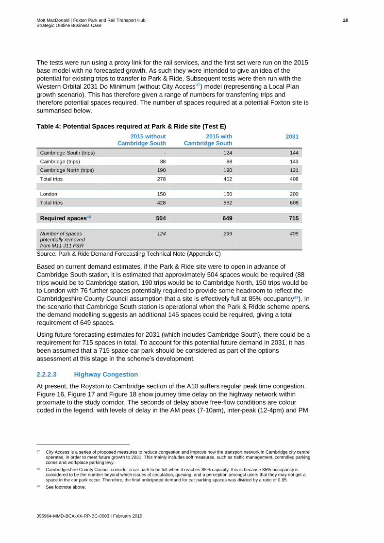
Mott MacDonald | Foxton Park and Rail Transport Hub 28 Strategic Outline Business Case
396964-MMD-BCA-XX-RP-BC-0003 | February 2019
The tests were run using a proxy link for the rail services, and the first set were run on the 2015
base model with no forecasted growth. As such they were intended to give an idea of the
potential for existing trips to transfer to Park & Ride. Subsequent tests were then run with the
Western Orbital 2031 Do Minimum (without City Access47) model (representing a Local Plan
growth scenario). This has therefore given a range of numbers for transferring trips and
therefore potential spaces required. The number of spaces required at a potential Foxton site is
summarised below.
Table 4: Potential Spaces required at Park & Ride site (Test E)
2015 without Cambridge South
2015 with Cambridge South
2031
Cambridge South (trips) - 124 144
Cambridge (trips) 88 88 143
Cambridge North (trips) 190 190 121
Total trips 278 402 408
London 150 150 200
Total trips 428 552 608
Required spaces48 504 649 715
Number of spaces potentially removed
from M11 J11 P&R
124 299 405
Source: Park & Ride Demand Forecasting Technical Note (Appendix C)
Based on current demand estimates, if the Park & Ride site were to open in advance of
Cambridge South station, it is estimated that approximately 504 spaces would be required (88
trips would be to Cambridge station, 190 trips would be to Cambridge North, 150 trips would be
to London with 76 further spaces potentially required to provide some headroom to reflect the
Cambridgeshire County Council assumption that a site is effectively full at 85% occupancy49). In
the scenario that Cambridge South station is operational when the Park & Ridde scheme opens,
the demand modelling suggests an additional 145 spaces could be required, giving a total
requirement of 649 spaces.
Using future forecasting estimates for 2031 (which includes Cambridge South), there could be a
requirement for 715 spaces in total. To account for this potential future demand in 2031, it has
been assumed that a 715 space car park should be considered as part of the options
assessment at this stage in the scheme’s development.
2.2.2.3 Highway Congestion
At present, the Royston to Cambridge section of the A10 suffers regular peak time congestion.
Figure 16, Figure 17 and Figure 18 show journey time delay on the highway network within
proximate to the study corridor. The seconds of delay above free-flow conditions are colour
coded in the legend, with levels of delay in the AM peak (7-10am), inter-peak (12-4pm) and PM
47 City Access is a series of proposed measures to reduce congestion and improve how the transport network in Cambridge city centre
operates, in order to meet future growth to 2031. This mainly includes soft measures, such as traffic management, controlled parking zones and workplace parking levy.
48 Cambridgeshire County Council consider a car park to be full when it reaches 85% capacity; this is because 85% occupancy is considered to be the number beyond which issues of circulation, queuing, and a perception amongst users that they may not get a
space in the car park occur. Therefore, the final anticipated demand for car parking spaces was divided by a ratio of 0.85.
49 See footnote above.

Mott MacDonald | Foxton Park and Rail Transport Hub 29 Strategic Outline Business Case
396964-MMD-BCA-XX-RP-BC-0003 | February 2019
peak (4-6pm), compared to periods of time considered free flow (1:30am – 5:30am50). This is
derived from Trafficmaster data taken from November 201551.
The figures show that high levels of congestion occur throughout the day along the A1309
Hauxton Road, which connects the A10 and M11 (at Junction 11) to the Southern Fringe, and
onward, via the A1134, to Cambridge City Centre.
Figure 16: Level of Delay – AM Peak (seconds of delay compared to free-flow)
Source: Mott MacDonald
50 Free flow time period selected to coincide with period when no passenger trains are running, therefore the effect of the level crossing
on delay is removed.
51 Trafficmaster data excludes weekends and holidays.
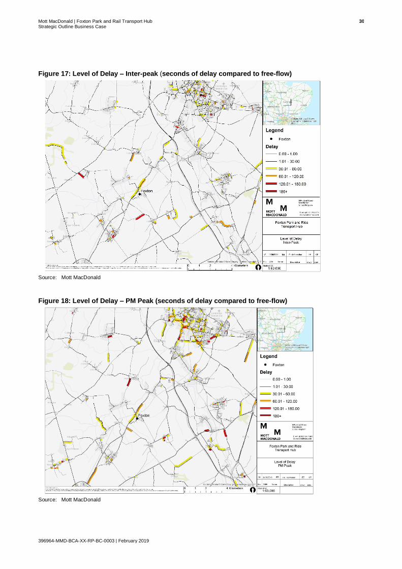
Mott MacDonald | Foxton Park and Rail Transport Hub 30 Strategic Outline Business Case
396964-MMD-BCA-XX-RP-BC-0003 | February 2019
Figure 17: Level of Delay – Inter-peak (seconds of delay compared to free-flow)
Source: Mott MacDonald
Figure 18: Level of Delay – PM Peak (seconds of delay compared to free-flow)
Source: Mott MacDonald

Mott MacDonald | Foxton Park and Rail Transport Hub 31 Strategic Outline Business Case
396964-MMD-BCA-XX-RP-BC-0003 | February 2019
M11 Junction 11 is a critical pinch point where two main corridors (M11 and A10). Journey time
delays on the approach to M11 Junction 11 can be variable with delays of up to 16 minutes
being experienced during the morning peak hour52. Here, queues can stretch back from
Junction 11 through to the northbound approach to the villages of Hauxton and Harston. In
addition, congestion on the A10 contributes to delays on the M11 J11 southbound off-slip road.
Further south on the corridor, frequent rail barrier closings occur at the Foxton level crossing on
the A10. Here, 6-9 barrier downtimes occur per hour causing large delays, which make journey
times unpredictable.
The results of Manual Traffic Surveys undertaken by Streetwise Ltd. on Monday 14th,
Wednesday 16th and Friday 18th May 2018, are presented in the Table 5 and Table 6 below.
The table shows the total length of time the Foxton level crossing was closed during the AM
(0800-0900) and PM (1700-1800) peaks. The average length of closure and number of closures
themselves are also shown between 7am and 7pm.
Table 5: Duration of Level Cross Closure at Foxton
Date AM – Duration of Crossing Closure
PM- Duration of Crossing Closure
Average Length of Closure (7am-7pm)
Number of Closures (7am-7pm)
Monday 14th May 2018 13 mins 20 mins 2 mins 15 secs 93
Wednesday 16th May 2018 15 mins 20 mins 2 mins 25 secs 91
Friday 18th May 2018 17 mins 19 mins 2 mins 24 secs 87
Source: Streetwise Ltd53
Table 5 shows that total barrier downtimes can exceed 15 minutes in the AM peak, and 20
minutes in the PM peak. These delays correspond with large queues on for both northbound
and southbound movements of the A10. The average maximum queue lengths are shown, both
northbound and southbound, in Table 6 below.
Table 6: Average Maximum Queue Length in the Peak Hours
Date AM – Average Max Queue (PCU)
PM - Average Max Queue (PCU)
Northbound Southbound Northbound Southbound
Monday 14th May 2018 28 31 55 32
Wednesday 16th May 2018 37 43 54 51
Friday 18th May 2018 29 33 40 29
Source: Streetwise Ltd54
Table 6 shows that queue lengths are longer in the PM peak than the AM peak. In the AM peak,
queues are broadly similar for northbound and southbound traffic. In the PM peak however,
queues are longer for traffic heading northbound toward Cambridge.
Traffic count data has also been collected along the A10 near the Melbourn Bypass (Figure 19).
This data was collected over a 12-hour period (7am-7pm) and provides two-way flow analysis55.
The results are presented in Table 7.
52 Atkins - Western Orbital Study Options Report (September 2015)
53 Surveys carried out for the purpose of the Foxton Level Crossing Bypass Strategic Outline Business Case (January 2019).
54 Surveys carried out for the purpose of the Foxton Level Crossing Bypass Strategic Outline Business Case (January 2019).
55 CCC, Road traffic data - https://www.cambridgeshire.gov.uk/residents/travel-roads-and-parking/roads-and-pathways/road-traffic-data/
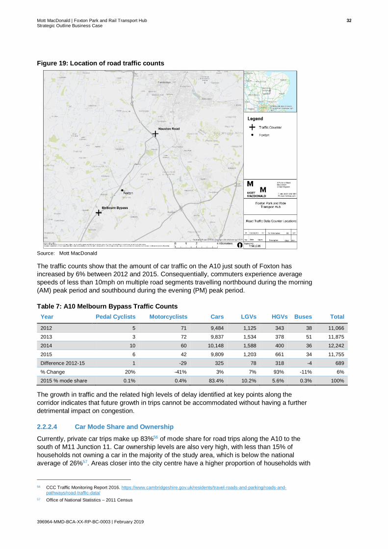
Mott MacDonald | Foxton Park and Rail Transport Hub 32 Strategic Outline Business Case
396964-MMD-BCA-XX-RP-BC-0003 | February 2019
Figure 19: Location of road traffic counts
Source: Mott MacDonald
The traffic counts show that the amount of car traffic on the A10 just south of Foxton has
increased by 6% between 2012 and 2015. Consequentially, commuters experience average
speeds of less than 10mph on multiple road segments travelling northbound during the morning
(AM) peak period and southbound during the evening (PM) peak period.
Table 7: A10 Melbourn Bypass Traffic Counts
Year Pedal Cyclists Motorcyclists Cars LGVs HGVs Buses Total
2012 5 71 9,484 1,125 343 38 11,066
2013 3 72 9,837 1,534 378 51 11,875
2014 10 60 10,148 1,588 400 36 12,242
2015 6 42 9,809 1,203 661 34 11,755
Difference 2012-15 1 -29 325 78 318 -4 689
% Change 20% -41% 3% 7% 93% -11% 6%
2015 % mode share 0.1% 0.4% 83.4% 10.2% 5.6% 0.3% 100%
The growth in traffic and the related high levels of delay identified at key points along the
corridor indicates that future growth in trips cannot be accommodated without having a further
detrimental impact on congestion.
2.2.2.4 Car Mode Share and Ownership
Currently, private car trips make up 83%56 of mode share for road trips along the A10 to the
south of M11 Junction 11. Car ownership levels are also very high, with less than 15% of
households not owning a car in the majority of the study area, which is below the national
average of 26%57. Areas closer into the city centre have a higher proportion of households with
56 CCC Traffic Monitoring Report 2016. https://www.cambridgeshire.gov.uk/residents/travel-roads-and-parking/roads-and-
pathways/road-traffic-data/
57 Office of National Statistics – 2011 Census

Mott MacDonald | Foxton Park and Rail Transport Hub 33 Strategic Outline Business Case
396964-MMD-BCA-XX-RP-BC-0003 | February 2019
no car ownership. This is likely to be, in part, a result of better public transport links, high cycle
mode share and shorter travel distances particularly concerning commuting trips. Figure 20
graphically presents the levels of car ownership across Cambridge and South Cambridgeshire
(2011 census).
Figure 20: No Car Ownership
Source: Mott MacDonald
The current transport network leaves few attractive alternatives to travel by car from areas to the
west of Junction 11 of the M11. There is limited scope for Park & Rail via existing stations in the
corridor, whilst the absence of frequent bus services (1bph) and priority measures along the
corridor coupled with long journey times and high travel costs, means travelling by bus is not a
viable or attractive travel option for many. Accordingly, bus mode share is just 0.3% based on
traffic counts along A10 Melbourn Bypass, as shown in Table 7.
A high-quality segregated cycle route is provided along sections of the A10 between Royston
and Cambridge, as shown in Figure 21. At present, the route runs from Melbourne and Frog
End to the east of Harston, and from the west of Harston into Cambridge. Accordingly, there is
both an opportunity to provide a complete segregated cycle link along the A10, as well as
potentially introducing cycle infrastructure on the local road network that is complimentary to the
existing cycle network.

Mott MacDonald | Foxton Park and Rail Transport Hub 34 Strategic Outline Business Case
396964-MMD-BCA-XX-RP-BC-0003 | February 2019
Figure 21: A10 Cycle Route
Source: GCP
2.2.2.5 Road Safety
Recent collision data for the Royston to Cambridge corridor shows a high incidence of
collisions, particularly at junctions. Between 2011 and 2015 there was a total of 62 collisions, of
which 48 were slight, 12 serious and 2 fatal, between Royston and M11 J1158.
Figure 22 shows that of the 62 collisions, 38 occurred between Royston and Foxton railway
station, comprising 28 slight, 8 serious and 2 fatal. The collisions were spread along the route
with one cluster at the A10 / Cambridge Road junction near Frog End.
58 Crash Map - www.crashmap.co.uk

Mott MacDonald | Foxton Park and Rail Transport Hub 35 Strategic Outline Business Case
396964-MMD-BCA-XX-RP-BC-0003 | February 2019
Figure 22: Map of accident data along A10
Source: Crash Map
Figure 23 shows that the other 24 collisions occurred between Foxton railway station and M11
J11, comprising 20 slight and 4 serious. The collisions were clustered around Harston, at M11
J11 and around the level crossing at Foxton station.
Figure 23: Map of accident data between Foxton railway station and M11 J11
Source: Crash Map

Mott MacDonald | Foxton Park and Rail Transport Hub 36 Strategic Outline Business Case
396964-MMD-BCA-XX-RP-BC-0003 | February 2019
2.2.2.6 Air Quality
There is no evidence of any current air quality issues along the A10 corridor between Royston
and Cambridge, although further research may be required to confirm this.
However, whilst individually main radial routes into the city centre, such as the A10, do not
highlight any air quality issues, there are air quality issues within Cambridge City Centre itself.
This is evident by the presence of an Air Quality Management Area (AQMA) as illustrated in
Figure 24. An AQMA is an area where national air quality objectives are unlikely to be met, and
a plan is put in place to improve the air quality accordingly. The Cambridge AQMA suffers from
poor air quality which is in part due to the high number of vehicles that enter the city centre,
some of which use the A10. Indeed, the Cambridge City Council webpage on air pollution states
that vehicle exhausts and local combustion are the “main sources of air pollution in the
Cambridge AQMA”59.
Promoting and enabling modal shift toward sustainable modes of transport is a central issue set
out within the Greater Cambridge City Deal and the various local transport strategy documents.
This includes the greater use of public transport modes such as bus and rail, with the provision
of additional Park & Ride sites also providing the opportunity to reduce current and future
growth in car trips and correspondingly the harmful pollutants within the Cambridge city centre
AQMA.
Figure 24: Air Quality Management Areas
Source: Mott MacDonald
59 Cambridge City Council. Air pollution internet information (www.cambridge.gov.uk/air-pollution-levels-and-monitoring-them)

Mott MacDonald | Foxton Park and Rail Transport Hub 37 Strategic Outline Business Case
396964-MMD-BCA-XX-RP-BC-0003 | February 2019
2.2.2.7 Growth in Rail Use
Cambridge has seen above national average growth in rail passengers over the past decade
including along the Cambridge line between Royston and Cambridge. With 62% growth at
Cambridge station and 47% at Foxton for example, demand is continuing to grow on the rail
network60.
A growth in rail passengers combined with the success of Park & Ride along the corridor,
suggests there is an opportunity to intercept existing and future car trips via rail services before
they arrive within Cambridge City Centre or at other destinations served by rail including at the
CNF and at the Southern Fringe subject to delivery of the proposed Cambridge South station.
2.2.2.8 Summary
60 Office of Rail and Road
What does this mean for a Park & Rail transport hub scheme?
Existing Park & Ride facilities are reaching capacity along the study corridor, with weekday
demand and occupancy being highest at Trumpington Park & Ride. Demand forecasts
suggest that approximately 800-900 additional spaces would be required by 2031 to
accommodate forecast demand at Trumpington. In addition, the frequency and reliability of
road-based public transport is poor along the A10 corridor due to high levels of congestion
and infrequent services.
Simultaneously, travel behaviours are changing along the corridor. For example, growth in
passenger footfall is above the national average at all rail stations in the study area,
including 62% growth at Cambridge station and 47% at Foxton. Despite this, private car trips
make up 83% of mode share for trips coming from the south and south-west into Cambridge
via the A10.
The Park & Rail scheme could thus provide an opportunity to increase the percentage of
people who regularly use public transport for commuting or leisure trips, by providing
improved access to existing high-quality rail services. This in turn could have a positive
impact on air quality within Cambridge City Centre, by reducing the number of potential
vehicles entering the AQMA.
The existing direct links to Cambridge and Cambridge North stations, and a potential future
link to the proposed Cambridge South station, means the proposed scheme also has the
potential to support housing and employment development along the corridor, including
development at the CNFE and Cambridge Southern Fringe areas.

Mott MacDonald | Foxton Park and Rail Transport Hub 38 Strategic Outline Business Case
396964-MMD-BCA-XX-RP-BC-0003 | February 2019
2.3 Policy Context
2.3.1 Policy Review
Any investment in transport infrastructure needs to align with national, regional, and local policy
and strategy. Key relevant points identified in regional and local policy and strategy documents
are set out in Table 8. Section 2.3.2 also sets out how this scheme aligns with emerging policy
such as the Cambridgeshire and Peterborough Combined Authority Mayoral Interim Transport
Strategy Statement.
Table 8: Alignment with local policy and strategy
Policy / Strategy
Greater Cambridge Partnership – City Deal (2014)61
Description ● The vision of the GCP is: “To unleash a second wave of the ‘Cambridge Phenomenon’, securing sustainable economic growth and quality of life for the people of Cambridge
and South Cambridgeshire”
● To support economic growth, the region must accommodate new and growing businesses/developments and the people who work in them whilst ensuring ease of movement between key economic hubs.
Relevance to the corridor ● A programme to enhance transport capacity is required along key strategic corridors to and from the city particularly where employment growth is planned.
● Development of a sustainable transport network is required to strengthen employment
hubs and high-tech clusters in Greater Cambridge making movement between them more straight forward, efficient and convenient.
● Areas along the A10, M11 J11, A1307 and A1309 are highlighted as transport links with severe capacity issues.
● Significant growth is expected throughout Cambridge and South Cambridgeshire; therefore, improved transport infrastructure will be required to support growth in this
area and ensure economic growth is delivered to its full potential.
Wider points of relevance
● Intercepting, or replacing, car trips before they enter the City can support these aspirations
● Park & Ride is one potential intervention that can help with this.
Cambridgeshire Long Term Transport Strategy (2015)62
Description ● There are 8 key objectives of this strategy which include supporting sustainable growth and economic prosperity, improving accessibility to employment and services and minimise the
impact of transport on the environment.
● This strategy identifies the major infrastructure requirements that are needed to address existing problems and capacity constraints on Cambridgeshire’s transport network, and the further infrastructure that is required to cater for the transport demand
associated with planned growth.
Relevance to the corridor ● The strategy suggests schemes that may be required to address capacity issues, including A10 Harston and Hauxton capacity and access improvements and the A10 Foxton level crossing replacement.
● This is a longer-term strategy and focuses on the provision of new transport capacity
on public transport, walking and cycling.
Wider points of relevance
● The strategy looks to provide or enhance integrated high quality public transport services on the main corridors into Cambridge, and states that Park & Ride services will continue to be an important travel option for people in rural areas in particular.
● The strategy states the aim of encouraging a modal shift onto public transport at an
earlier stage in journeys, by intercepting car traffic at rural travel hubs or Park & Ride sites.
61 Greater Cambridge Partnership - Greater Cambridge City Deal (2014)
62 Cambridge County Council – Long Term Transport Strategy (2015)

Mott MacDonald | Foxton Park and Rail Transport Hub 39 Strategic Outline Business Case
396964-MMD-BCA-XX-RP-BC-0003 | February 2019
Policy / Strategy
Cambridgeshire Local Transport Plan 3 (2015)63
Description ● The third Local Transport Plan (LTP3) addresses Cambridgeshire County Council’s (CCC) transport priorities.
● It seeks to address existing transport challenges as well as ensuring that planned
large-scale development can take place in the county in a sustainable way.
Relevance to the corridor ● The LTP3 refers to the A10 Foxton level crossing closure scheme. This is expected to bring benefits to the Royston to Cambridge corridor such as improving access to development sites, settlements and jobs along the corridor.
Wider points of relevance
• Any transport interventions in the A10 corridor will need to be compliant with policy set out in the LTP. However, the Combined Authority has a duty to prepare a revised LTP and has set a target completion date of Spring 2019. This will provide the revised local transport planning policy backdrop for schemes promoted for the A10 corridor.
Transport Strategy for Cambridge and South Cambridgeshire (2014)64
Description ● The Transport Strategy for Cambridge and South Cambridgeshire (TSCSC) seeks to address a wide range of transport challenges in the district of South Cambridgeshire, the
city of Cambridge and the transport corridors beyond the district boundaries.
● The TSCSC has eight objectives which support sustainable growth, enhanced transport network and accessibility, air quality targets, quality of life and health and wellbeing.
● Many of the measures help to facilitate and support new developments and take account of jobs and housing growth planned in Cambridge and South Cambridgeshire.
Relevance to the corridor ● The A10 is identified within the TSCSC as one of the main corridors in need of improvement.
● The TSCSC plans for vehicular trips to be intercepted further along the A10 through the provision of a new Park & Ride site, freeing up capacity at the existing Trumpington
Park & Ride.
● A core ambition of the strategy document, outlined in Policy TSCSC 15, is for the majority of car traffic accessing the city centre to use rural hubs or Park & Ride hubs, to allow for the strategic and local road network to be accessible and operate efficiently
and reliably. The document specifically outlines the need for “New, replacement or improved Park & Ride capacity and facilities at or near to the existing ring of five sites serving the city will be delivered” (Pg. 19).
– Park & Rail has the potential to enhance connectivity between Cambridge and rural
outer-lying parishes where sustainable transport options are limited.
● The document also highlights the importance of transport interchanges and highlights how “the convenience and timeliness of interchange is an important factor in many people’s choice of how to travel”.
– The proposed transport interchange could form a key node in the network of
transport interchanges within South Cambridgeshire and Cambridge; thus, enabling rural residents to access HQPT services more easily.
Wider points of relevance
● The TSCSC contains 21 policies, many of which point towards Park & Ride solutions such as:
– Policy TSCSC 3: Additional travel demand on the constrained transport network of South Cambridgeshire and into Cambridge should be accommodated by passenger
transport services on main radial corridors.
– Policy TSCSC 7: Outer Park & Ride sites will be introduced, and existing Park & Ride sites will be expanded or relocated.
– Policy TSCSC 9: Access to jobs and services - access to areas of employment and services will be maximised by sustainable modes of travel.
– Policy TSCSC 19: Carbon Emissions- by offering commuters a sustainable option for
a portion of their journey, enhanced Park & Ride will reduce carbon emissions per person, helping reduce the transport related carbon emissions and achieve targets.
• The relevance of these policies will need to be monitored and reviewed as the replacement CA-led LTP is developed and published in Spring 2019.
63 Cambridge County Council – The Local Transport Plan 3 (2015)
64 Cambridge County Council – Cambridge Coty and South Cambridgeshire Transport Strategy (2014)

Mott MacDonald | Foxton Park and Rail Transport Hub 40 Strategic Outline Business Case
396964-MMD-BCA-XX-RP-BC-0003 | February 2019
Policy / Strategy
Greater Cambridge Greater Peterborough Strategic Economic Plan (2015)65
Description • The key goal of the Greater Cambridge Greater Peterborough Strategic Economic Plan (SEP), prepared by the Local Enterprise Partnership (LEP) is to develop their internationally competitive, nationally significant economy bringing together the diverse
strengths of the area to ensure economic growth that benefits the whole area.
Relevance to the corridor ● The A10 is identified as a key strategic route to move goods and people within and
through the area.
Wider points of
relevance • The SEP states that high-quality Park & Ride services must be provided in order to
encourage people to use it.
Cambridge Local Plan (2018)66
Description • Cambridge City Local Plan, adopted in 2018, sets out the vision, objectives and strategy for
future development and spatial planning requirements of Cambridge up to 2031.
• The Local Plan seeks to guide and facilitate growth in a sensitive and sustainable manner, ensuring that the high environmental quality of the City is protected and enhanced and
that future developments offer a full range of opportunities to all its citizens.
Relevance to the corridor ● The Local Plan highlights the Southern Fringe as an area of major change and states that proposals in this area should create distinctive gateways to the City when
approached by road and rail. The corridor leads towards the Southern Fringe and
therefore provides a key route into this area of development.
● Policy 80 sets out the Plan’s ambition to prioritise access by sustainable modes of travel. Policy 80 sets out that public transport has a crucial role to play in meeting Cambridge’s transport needs” and in particular that proposed developments should
“minimise additional car traffic in the surrounding area”. A Park & Rail transport hub in this corridor could intercept Cambridge-bound traffic on the A10 and should potentially
reduce disruptive on-street parking in impacted settlements.
● Policy 81 concerns the transport impact of development and specifies that developments will only be permitted where they have an acceptable transport impact.
The proposed transport interchange site is likely to alleviate congestion on the A10 and on Cambridge’s highway network by reducing the volume of cars travelling into Cambridge; thus, reducing the impacts of congestion on sustainable modes of
transport and the attractiveness of the private car.
● Policy 85 of the Local Plan concerns the impact of proposed development on local
infrastructure, stating that there must be sufficient infrastructure capacity to support the new development. The proposed development will provide improved transport infrastructure to support new development in Cambridge City Centre, the CNFE and
Cambridge Biomedical Campus; thus, supporting the growth directive of the local plan.
Wider points of
relevance
● The Local Plan includes the provision for extension of Park & Ride services to Addenbrooke’s Hospital and other southern fringe developments in order to meet the needs of the resident and working population. This supports objectives and goals in the
plan such as supporting economic growth, minimising distances people need to travel, improving accessibility to jobs and services through the sustainable transport network.
There is no mention of a further Park & Ride site in the wider A10 southern corridor.
South Cambridgeshire Local Plan (2018)67
Description ● The Local Plan is based on the three principles of sustainability including economic, social and environmental to ensure a competitive economy, healthy communities and
protection of the environment.
Relevance to the corridor ● The Local Plan defines Foxton as a ‘Group Village’ and therefore only some of the basic day-to-day requirements of residents can be met without the need to travel outside the village therefore sustainable transport links are key to connecting residents
with employment and services.
● Acknowledgment that high levels of congestion exist on radial routes into Cambridge at
peak times.
Wider points of
relevance ● At the time of writing, the Plan has been adopted.
65 Greater Cambridge Greater Peterborough Enterprise Partnership – Strategic Economic Plan (2014)
66 Cambridge City Council – Cambridge Local Plan 2014: Proposed Submission, July 2013
67 South Cambridgeshire District Council – South Cambridgeshire Local Plan 2018
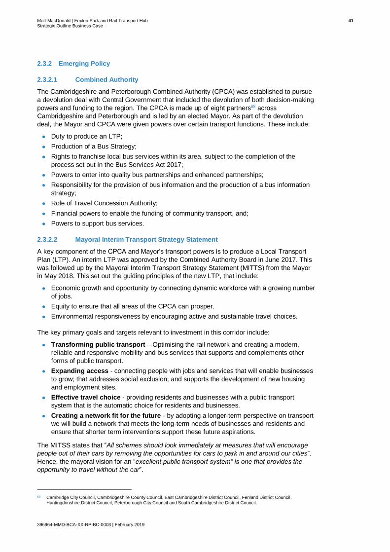
Mott MacDonald | Foxton Park and Rail Transport Hub 41 Strategic Outline Business Case
396964-MMD-BCA-XX-RP-BC-0003 | February 2019
2.3.2 Emerging Policy
2.3.2.1 Combined Authority
The Cambridgeshire and Peterborough Combined Authority (CPCA) was established to pursue
a devolution deal with Central Government that included the devolution of both decision-making
powers and funding to the region. The CPCA is made up of eight partners68 across
Cambridgeshire and Peterborough and is led by an elected Mayor. As part of the devolution
deal, the Mayor and CPCA were given powers over certain transport functions. These include:
● Duty to produce an LTP;
● Production of a Bus Strategy;
● Rights to franchise local bus services within its area, subject to the completion of the
process set out in the Bus Services Act 2017;
● Powers to enter into quality bus partnerships and enhanced partnerships;
● Responsibility for the provision of bus information and the production of a bus information
strategy;
● Role of Travel Concession Authority;
● Financial powers to enable the funding of community transport, and;
● Powers to support bus services.
2.3.2.2 Mayoral Interim Transport Strategy Statement
A key component of the CPCA and Mayor’s transport powers is to produce a Local Transport
Plan (LTP). An interim LTP was approved by the Combined Authority Board in June 2017. This
was followed up by the Mayoral Interim Transport Strategy Statement (MITTS) from the Mayor
in May 2018. This set out the guiding principles of the new LTP, that include:
● Economic growth and opportunity by connecting dynamic workforce with a growing number
of jobs.
● Equity to ensure that all areas of the CPCA can prosper.
● Environmental responsiveness by encouraging active and sustainable travel choices.
The key primary goals and targets relevant to investment in this corridor include:
● Transforming public transport – Optimising the rail network and creating a modern,
reliable and responsive mobility and bus services that supports and complements other
forms of public transport.
● Expanding access - connecting people with jobs and services that will enable businesses
to grow; that addresses social exclusion; and supports the development of new housing
and employment sites.
● Effective travel choice - providing residents and businesses with a public transport
system that is the automatic choice for residents and businesses.
● Creating a network fit for the future - by adopting a longer-term perspective on transport
we will build a network that meets the long-term needs of businesses and residents and
ensure that shorter term interventions support these future aspirations.
The MITSS states that “All schemes should look immediately at measures that will encourage
people out of their cars by removing the opportunities for cars to park in and around our cities”.
Hence, the mayoral vision for an “excellent public transport system” is one that provides the
opportunity to travel without the car”.
68 Cambridge City Council, Cambridgeshire County Council. East Cambridgeshire District Council, Fenland District Council,
Huntingdonshire District Council, Peterborough City Council and South Cambridgeshire District Council.
Mott MacDonald | Foxton Park and Rail Transport Hub 42 Strategic Outline Business Case
396964-MMD-BCA-XX-RP-BC-0003 | February 2019
Following the publication of the MITSS, the CPCA and the Mayor approved the MITSS at its
meeting in May 2018, and committed the CPCA to undertaking a review of the features and
timeframes for all transport corridors to ascertain their alignment with it. The GCP is now
working to the CPCA agreed transport plan and is pursuing schemes that can demonstrably
provide building blocks towards the Mayor’s future vision.
In terms of Park & Ride, the MITSS proposed that the Park & Ride elements of the GCP
projects be “implemented as temporary solutions to reflect the MITSS aspiration to connect the
Metro stops with the wider population through innovative transit solutions and not the private
car. This aspiration includes providing more infrastructure to support greater use of cycle and
footpaths, and to put in place measures that move away from a reliance on private cars for short
term and commuter journeys”.
A full Local Transport Plan for the CA area is expected to be completed during 2019.
2.3.3 Summary
What does this mean for a Park & Rail transport hub scheme?
The proposed scheme supports transport objectives identified in national and local policy,
and clearly aligns with GCP’s growth strategy.
The A10 is identified as a key strategic route for moving goods and people within Greater Cambridge but is currently subject to high-levels of congestion and limited public transport provision within the study corridor.
Accordingly, the scheme proposes to enhance access to existing high-quality rail services in
order to make movement within the study corridor more straight forward, efficient and
convenient.
Links to Cambridge and Cambridge North stations, and potentially to the proposed
Cambridge South station, means the proposed scheme could connect the residents of South
Cambridgeshire to key employment growth areas such as the CNF and Southern Fringe,
and sites accessible via Cambridge station. Therefore, the scheme has the potential to
strengthen employment hubs and high-tech clusters in Greater Cambridge.
Furthermore, the proposed transport scheme site is likely to alleviate congestion in the study
corridor by intercepting Cambridge-bound traffic at an earlier point on the A10. This could in
turn benefit Cambridge’s highway network and air quality by reducing the volume of cars
travelling into the city centre. Hence, the scheme also has the potential to reduce the
impacts of congestion on sustainable modes of transport; thereby, enhancing their
attractiveness.

Mott MacDonald | Foxton Park and Rail Transport Hub 43 Strategic Outline Business Case
396964-MMD-BCA-XX-RP-BC-0003 | February 2019
2.4 Underlying Drivers – The Need for Intervention
Taking into account the policy context, as well as the current opportunities, aspirations and
issues, the following key underlying drivers for the need for investment in a new Park & Ride
transport hub along the A10 between Royston to Cambridge are:
● Lack of Park & Ride capacity:
– The success of the Park & Ride at Trumpington demonstrates that there is a demand for
Park & Ride along the Royston to Cambridge route. However, Trumpington is now
reaching 80-85% capacity, and would potentially require 600-700 additional spaces by
2031 to accommodate future demand. This may not be achievable and additional Park &
Ride provision is required.
– There is an opportunity to provide transport interchange facilities further out from
Cambridge that complement existing and proposed provision at M11 Junction 11.
– Demand modelling indicates that there is the potential demand for up to 650 car parking
spaces at a Park & Ride site in this corridor, with the potential for additional 65 spaces by
2031 (715 in total).
● High levels of congestion:
– High levels of delay at key points along the Royston to Cambridge route indicate that future
growth in trips cannot be accommodated without having a further detrimental impact on
congestion.
– In particular, to reduce the impact of further traffic delay along the A10 to the west of the M11,
along the A1309 Hauxton Road to the east of the M11 and along the A1134, there is therefore a
need to remove vehicle trips from the road.
● High levels of car mode share and ownership:
– Currently, private car trips make up 83% of road-based mode share for trips travelling along
the A10 south of the M11 Junction 1169.
– Car ownership levels are also very high with less than 15% of study area households not
owning a car which is significantly lower than the national average of 26%.
● Lack of alternative sustainable modes:
– The current transport network leaves few attractive alternatives to travel by car from areas to
the west of the M11 Junction 11.
– Current stations do not provide adequate Park & Ride facilities, whilst the absence of
frequent bus services (1bph) and bus priority along the route, coupled with long journey
times and high travel costs, mean travelling by bus is not a viable or attractive option of
travel. The current bus-based mode share is just 0.3% based on traffic counts along A10
Melbourn Bypass.
● High number of road collisions:
– Opportunity to have a positive impact on the number of road traffic collisions along the
Royston to Cambridge corridor by encouraging a mode shift to public transport for some
of the journey, and therefore potentially reducing the number of cars using this route.
● Air quality issues in Cambridge:
– Poor air quality in Cambridge City Centre due to the high number of vehicles, as evident
by the existing AQMA. Opportunity to contribute to improving air quality within the city
centre by reducing the current number of vehicles entering the city centre and limiting
future growth by encouraging greater use of public transport.
69 A10 Melbourn Bypass Traffic Counts - 2015
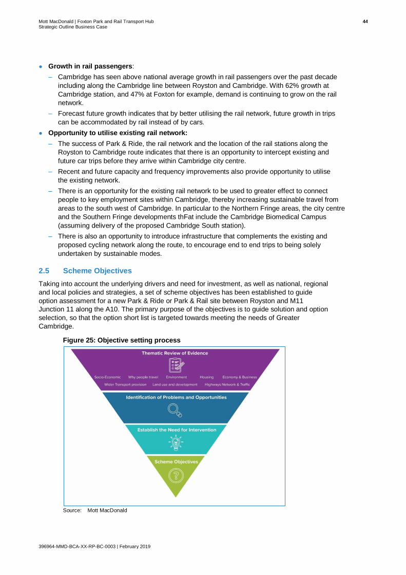
Mott MacDonald | Foxton Park and Rail Transport Hub 44 Strategic Outline Business Case
396964-MMD-BCA-XX-RP-BC-0003 | February 2019
● Growth in rail passengers:
– Cambridge has seen above national average growth in rail passengers over the past decade
including along the Cambridge line between Royston and Cambridge. With 62% growth at
Cambridge station, and 47% at Foxton for example, demand is continuing to grow on the rail
network.
– Forecast future growth indicates that by better utilising the rail network, future growth in trips
can be accommodated by rail instead of by cars.
● Opportunity to utilise existing rail network:
– The success of Park & Ride, the rail network and the location of the rail stations along the
Royston to Cambridge route indicates that there is an opportunity to intercept existing and
future car trips before they arrive within Cambridge city centre.
– Recent and future capacity and frequency improvements also provide opportunity to utilise
the existing network.
– There is an opportunity for the existing rail network to be used to greater effect to connect
people to key employment sites within Cambridge, thereby increasing sustainable travel from
areas to the south west of Cambridge. In particular to the Northern Fringe areas, the city centre
and the Southern Fringe developments thFat include the Cambridge Biomedical Campus
(assuming delivery of the proposed Cambridge South station).
– There is also an opportunity to introduce infrastructure that complements the existing and
proposed cycling network along the route, to encourage end to end trips to being solely
undertaken by sustainable modes.
2.5 Scheme Objectives
Taking into account the underlying drivers and need for investment, as well as national, regional
and local policies and strategies, a set of scheme objectives has been established to guide
option assessment for a new Park & Ride or Park & Rail site between Royston and M11
Junction 11 along the A10. The primary purpose of the objectives is to guide solution and option
selection, so that the option short list is targeted towards meeting the needs of Greater
Cambridge.
Figure 25: Objective setting process
Source: Mott MacDonald

Mott MacDonald | Foxton Park and Rail Transport Hub 45 Strategic Outline Business Case
396964-MMD-BCA-XX-RP-BC-0003 | February 2019
2.5.1 Scheme Objectives
Based on the need for investment, the following scheme objectives have been established to
provide the overarching direction for this scheme to ensure it addresses the identified issues
and opportunities.
Figure 26: Scheme Objectives70
For each scheme objective a series of measurable sub-objectives have been identified that
inform the assessment criteria used to test the options and identify the best performing solution.
These sub-objectives are set out in Table 9.
Table 9: Scheme Sub-Objectives
Objective Sub-Objectives
E. Maximise the potential for all journeys to be undertaken by sustainable modes of transport
A-1 To increase sustainable transport mode share for trips into the city centre, the Cambridge Northern Fringe East and Southern Fringe areas, from trips originating from the south and south west along the Royston to Cambridge route.
A-2 To increase Park & Ride capacity along the Royston to Cambridge A10 corridor directly serving key areas of employment.
A-3 To reduce journey times from Park & Ride site to key employment areas to enable public transport journeys to compete more effectively with the private car.
F. Improved overall connectivity and accessibility within Greater Cambridge to support economic growth
B-1 To increase connectivity between settlements along the Royston to Cambridge route and the city centre, and the Northern and Southern Fringe areas.
G. To accommodate future growth in trips along the Royston to Cambridge route and reduce impact on traffic levels and congestion
C-1 No significant increase in traffic flows along the A10 between Royston and the M11 Junction 11.
H. Contribute to enhanced quality of life for those living and working within Greater Cambridge
D-1 To improved quality of life within Greater Cambridge by minimising traffic impacts on the environment along the Royston to Cambridge A10 corridor.
D-2 To increase cycling and walking along the Royston to Cambridge A10 corridor.
Source: Mott MacDonald
70 Scheme objectives developed based on the identified issues and opportunities and in conjunction with GCP.

Mott MacDonald | Foxton Park and Rail Transport Hub 46 Strategic Outline Business Case
396964-MMD-BCA-XX-RP-BC-0003 | February 2019
2.6 Measures for Success
The following section summarises how the objectives set out in section 2.4 are made
accountable through the implementation of measurable success indicators.
Firstly, a logic map which details how the objectives set out in section 2.4 ultimately link to the
desired outcomes of the proposed scheme, is presented below.
Figure 27: Logic Map
Source: Mott MacDonald

Mott MacDonald | Foxton Park and Rail Transport Hub 47 Strategic Outline Business Case
396964-MMD-BCA-XX-RP-BC-0003 | February 2019
The measurable objectives and sub-objectives set out above have been assigned at least one
indicator to allow the performance of the scheme, once delivered, to be measured over time.
The proposed success indicators are set out in Table 10. These will be further developed during
the preparation of the OBC should the scheme be taken forward to the next stage.
Table 10: Proposed success indicators
Proposed indicators Relating to objective
• Park & Ride patronage from Foxton to Cambridge City Centre / Southern Fringes / Northern Fringe East.
• Number of trips to Cambridge City Centre / Southern Fringes / Northern Fringe East using rail.
A-1 To increase sustainable transport mode share for trips into the city centre, the Northern Fringe East and Southern Fringe areas, from trips originating from the south and south west along the Royston to Cambridge route.
• Number of Park & Ride spaces along the Royston to Cambridge corridor.
A-2 To increase Park & Ride capacity along the Royston to Cambridge A10 corridor.
• Journey times on the A10 Harston to J11.
• Average journey times for all commuters along the A10 corridor from the south west.
A-3 To reduce journey times from Park & Ride site to key employment areas.
• Number of people within an acceptable journey time of employment opportunities within Cambridge City Centre / Southern Fringes / Northern Fringe East
B-1 To increase connectivity between settlements along the Royston to Cambridge route.
• Traffic flow through Harston and Hauxton.
• Traffic flow on the approach to the Junction 11 of the M11.
C-1 No significant increase in traffic flows along the A10 between Royston and the M11 Junction 11.
• Air quality within the city centre to be within acceptable levels.
D-1 To improved quality of life within Greater Cambridge by minimising traffic impacts on the environment along the Royston to Cambridge A10 corridor.
• Number of journeys being undertaken using cycling and walking, including those to access the Park & Ride site.
D-2 To increase cycling and walking along the Royston to Cambridge A10 corridor.
Source: Mott MacDonald
Further detail on how scheme performance is to be assessed will be provided in the Benefits
Realisation Plan at the next business case stage, Outline Business Case, should the scheme be
taken further forward.
Mott MacDonald | Foxton Park and Rail Transport Hub 48 Strategic Outline Business Case
396964-MMD-BCA-XX-RP-BC-0003 | February 2019
2.7 Options Assessment
The following section summarises the details of the appraisal and sifting processes used during
the multi-stage optioneering process.
2.7.1 Method Overview
Since the project’s inception, the scheme has progressed through a series of optioneering steps
to identify and assess options that address the scheme objectives. The aim of this process was
to identify a preferred location for a proposed Park & Ride scheme. The detailed options
assessment process, including the results are set out in Appendix A – Options Assessment
Report.
The options assessment for this scheme followed the DfT’s guidance ‘The Transport Appraisal
Process’, which provides detailed guidance on appraisal and the requirements needed for
transport intervention. A structured approach sets out the necessary steps from initial
intervention through to detailed appraisal. The approach taken is designed to support the
preparation of business or investment cases to subsequent approval stages and post
implementation evaluation (see Figure 28 and Figure 29 which illustrate the DfT process).
The three stages in the DfT’s transport appraisal process are shown below:
• Stage 1 – Option Development. This involves identifying the need for intervention and
developing options to address a clear set of locally developed objectives that express
desired outcomes. The options are then sifted to identify the better performing options,
which are progressed to a further detailed appraisal in Stage 2.
• Stage 2 – Further Appraisal of a small number of better performing options. Stage 2 is
designed to enable decision-makers to make a rational and auditable decision about
whether or not to proceed with intervention. The further analysis focuses on estimating the
likely performance and impacts of intervention(s) in sufficient detail.
• Stage 3 – Implementation, Monitoring and Evaluation.

Mott MacDonald | Foxton Park and Rail Transport Hub 49 Strategic Outline Business Case
396964-MMD-BCA-XX-RP-BC-0003 | February 2019
Figure 28: Stage 1 of the Transport Appraisal Process (‘Option Development’)
Source: DfT (2014), Transport Analysis Guidance: The Transport Appraisal Process
Figure 29: Stage 2 of the Transport Appraisal Process (‘Further Appraisal’)
Source: DfT (2014), Transport Analysis Guidance: The Transport Appraisal Process

Mott MacDonald | Foxton Park and Rail Transport Hub 50 Strategic Outline Business Case
396964-MMD-BCA-XX-RP-BC-0003 | February 2019
The options appraisal process carried out to date for the proposed scheme and reported on in
the OAR (Appendix A) was structured to align with Stage 1 of the DfT’s transport appraisal
model. Our tailored approach to the process is illustrated in Figure 30.
Figure 30: Options Assessment Framework Three Step Approach71
Source: Mott MacDonald
Step 0 – Establishing the need for intervention
Step 0 includes identifying the need for intervention and investment in a Park & Ride transport
hub along the A10 Royston to Cambridge based on the issues and opportunities identified from
the transport evidence review, the strategy and policy review, demand modelling and the
establishment of the strategic economic case.
Taking into account the opportunities, aspirations and problems identified that underpin the
need for investment, a set of scheme objectives have been established to guide the option
assessment for investment in Park & Ride facilities along the A10 corridor between Royston and
Cambridge. These objectives are also aligned to existing policy and strategy to guide the
solutions and options selection. Hence, the options short list is targeted towards meeting the
needs of Greater Cambridge.
71 Whilst there are three steps in this process, the numbering of the steps as 0-2 reflects the 2 steps involved in the actual options
generation and assessment process. For consistency, these have therefore been labelled the same throughout the report.
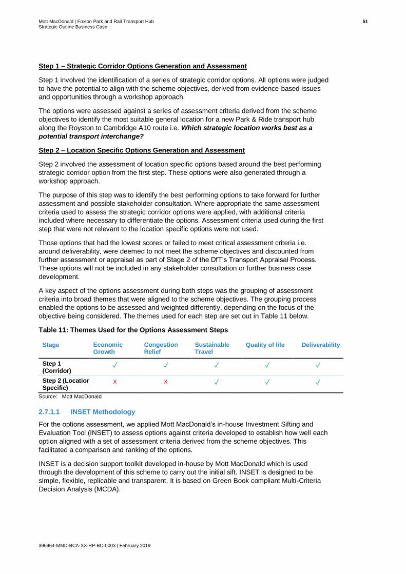
Mott MacDonald | Foxton Park and Rail Transport Hub 51 Strategic Outline Business Case
396964-MMD-BCA-XX-RP-BC-0003 | February 2019
Step 1 – Strategic Corridor Options Generation and Assessment
Step 1 involved the identification of a series of strategic corridor options. All options were judged
to have the potential to align with the scheme objectives, derived from evidence-based issues
and opportunities through a workshop approach.
The options were assessed against a series of assessment criteria derived from the scheme
objectives to identify the most suitable general location for a new Park & Ride transport hub
along the Royston to Cambridge A10 route i.e. Which strategic location works best as a
potential transport interchange?
Step 2 – Location Specific Options Generation and Assessment
Step 2 involved the assessment of location specific options based around the best performing
strategic corridor option from the first step. These options were also generated through a
workshop approach.
The purpose of this step was to identify the best performing options to take forward for further
assessment and possible stakeholder consultation. Where appropriate the same assessment
criteria used to assess the strategic corridor options were applied, with additional criteria
included where necessary to differentiate the options. Assessment criteria used during the first
step that were not relevant to the location specific options were not used.
Those options that had the lowest scores or failed to meet critical assessment criteria i.e.
around deliverability, were deemed to not meet the scheme objectives and discounted from
further assessment or appraisal as part of Stage 2 of the DfT’s Transport Appraisal Process.
These options will not be included in any stakeholder consultation or further business case
development.
A key aspect of the options assessment during both steps was the grouping of assessment
criteria into broad themes that were aligned to the scheme objectives. The grouping process
enabled the options to be assessed and weighted differently, depending on the focus of the
objective being considered. The themes used for each step are set out in Table 11 below.
Table 11: Themes Used for the Options Assessment Steps
Stage Economic Growth
Congestion Relief
Sustainable Travel
Quality of life
Deliverability
Step 1 (Corridor)
✓ ✓ ✓ ✓ ✓
Step 2 (Location Specific)
x x ✓ ✓ ✓
Source: Mott MacDonald
2.7.1.1 INSET Methodology
For the options assessment, we applied Mott MacDonald’s in-house Investment Sifting and
Evaluation Tool (INSET) to assess options against criteria developed to establish how well each
option aligned with a set of assessment criteria derived from the scheme objectives. This
facilitated a comparison and ranking of the options.
INSET is a decision support toolkit developed in-house by Mott MacDonald which is used
through the development of this scheme to carry out the initial sift. INSET is designed to be
simple, flexible, replicable and transparent. It is based on Green Book compliant Multi-Criteria
Decision Analysis (MCDA).

Mott MacDonald | Foxton Park and Rail Transport Hub 52 Strategic Outline Business Case
396964-MMD-BCA-XX-RP-BC-0003 | February 2019
2.7.2 Options Development
The options were developed at as part of a two-part workshop between CCC/GCP officers,
Skanska design consultants and Mott MacDonald transport consultants. The first part of the
workshop focused on the strategic corridor options between Royston and Cambridge along the
A10, and the second part focused on location specific options.
2.7.3 Step 1: Strategic Corridor Options Assessment
2.7.3.1 Strategic Corridor Options
8 strategic options were identified along the corridor, including bus based and rail-based Park &
Ride locations. The primary factor for identifying each option was whether they were located
between Royston and the M11 Junction 11. The two options associated with the Cambridge
South West Park & Ride proposals, the expansion of Trumpington Park & Ride and the M11
Junction 11 Park & Ride, were also included in the assessment. These sites were included as
options to allow for a comparison within the options assessment. It should be noted that
because the Trumpington Park & Ride site already exists, the site scores very highly on criteria
pertaining to sustainable travel and deliverability.
In addition, one of the main aims of the M11 J11 site is to capture trips from the M11, and
relieve congestion and provide additional capacity at M11 Junction 11. However, the purpose of
the options sifting process was to assess the impacts of a Park & Ride scheme along the A10
corridor; hence, the assessment criteria are primarily focused on capturing trips from the A10.
Therefore, the benefits the M11 J11 site brings to users of the M11, and M11 J11, are not
intended to be fully captured in this assessment.
The full list of options are presented in Table 12 below.
Table 12: Strategic Corridor Options Descriptions
No. Option Name Option Description
1 Trumpington Bus based Park & Ride option. Expansion of existing Trumpington Park &
Ride.
2 M11 Junction 11 Bus based Park & Ride option. New Park & Ride site situated in the vicinity
of M11 Junction 11 – this may be to the north, south, east or west.
3 Hauxton Bus based Park & Ride option. Situated to the west of the A10 near the
junction of A10 Cambridge Road and Church Road next to Hauxton village.
4 Harston Bus based Park & Ride option. Situated either to the east or west of the
A10 on the approach to Harston village from the west.
5 Foxton Rail based Park & Ride option. Situated on the A10 in the vicinity around
Foxton rail station.
6 Shepreth Rail based Park & Ride option. Situated east or west off Barrington Road
to the north of Shepreth rail station.
7 Meldreth Rail based Park & Ride option. Situated off Station Road to the south of
Meldreth rail station.
8 Royston Rail based Park & Ride option. Expansion of current Royston rail station
car park (not including any decking).
Source: Mott MacDonald

Mott MacDonald | Foxton Park and Rail Transport Hub 53 Strategic Outline Business Case
396964-MMD-BCA-XX-RP-BC-0003 | February 2019
Figure 31: Royston to Cambridge Corridor – Strategic Park & Ride Options
Source: Mott MacDonald
2.7.3.2 Step 1 Options Assessment Results
The eight locations have been assessed based on the extent to which they would be able to
meet the scheme objectives and based on environmental constraints.
The results of the Strategic Corridor options assessment within INSET are summarised in Table
13 with the options ranked by their final score. The total score column provides an overall score
for each key theme. The total score is based on the appraisal of criteria detailed in the OAR
(Appendix A).
All scores have been normalised so that the results shown are out of 1. All themes, main criteria
and sub-criteria have been weighted equally. The higher scores for each theme have been
shaded in dark green, with middle scores highlighted in lighter green and lower scores in yellow.
Table 13: INSET Results – Strategic Corridor Options
Rank Option Sustainable Travel
Economic Growth
Congestion Theme
Quality of Life
Deliverability Total Score
1st Trumpington 0.87 0.67 1.00 0.70 1.00 0.85
2nd Foxton 0.81 0.50 1.00 0.70 0.89 0.78
3rd M11 Junction 11 0.78 0.67 1.00 0.70 0.67 0.76
4th Meldreth 0.74 0.50 1.00 0.65 0.89 0.76
5th Shepreth 0.68 0.50 1.00 0.50 0.89 0.71
6th Royston 0.35 0.83 1.00 0.50 0.78 0.69
7th Hauxton 0.65 0.33 0.50 0.68 0.11 0.45
8th Harston 0.67 0.17 0.50 0.65 0.11 0.42
Source: Mott MacDonald

Mott MacDonald | Foxton Park and Rail Transport Hub 54 Strategic Outline Business Case
396964-MMD-BCA-XX-RP-BC-0003 | February 2019
The INSET process determined that the highest scoring potential sites, were as follows:
● Trumpington Expansion
● Foxton
● M11 Junction 11
● Meldreth
It should be noted that the assessment criteria are primarily based on each options impact on
the A10 Royston to Cambridge corridor. Hence, benefits derived from improvements to the M11
are not considered. Moreover, M11 Junction 11 scores lower than the Foxton and Trumpington
options on sustainable travel, because existing transport services are not provided at the
proposed location.
Overall these schemes scored between 0.76 and 0.85. Across each theme these schemes
scored predominately high or very high scores.
The second highest scoring group of potential sites are listed below:
• Shepreth
• Royston
These sites are adjacent to existing train stations that provide direct rail services to both
Cambridge and London, and thus scored particularly highly on the congestion and deliverability
themes.
The lowest scoring group of sites, scoring less than 0.5 overall, were as follows:
• Harston
• Hauxton
The Harston and Hauxton sites scored particularly poorly on deliverability due to their Green
Belt location, and space constraints in both villages. Both sites also scored poorly on
congestion, due to their probable reliance on the highway network for any proposed High
Quality Public Transport services. A combination of poor journey time reliability and low
accessibility to the existing housing stock, resulted in a poor score on economic growth.
2.7.3.3 Step 1 Options Assessment Summary
Step 1 of the INSET process indicated that Trumpington, Foxton and M11 J11 were the three
highest scoring sites..
The results from the INSET assessment thus support the parallel development of the
Trumpington Park & Ride Expansion or M11 Junction 11 Park & Ride site and indicate that
Foxton is the best performing location of the remaining strategic locations along the A10
corridor.
Whilst the Meldreth score (scoring 0.76 out of 1) is close to that of Foxton, Foxton is still shown
to be the best performing rail-based option (scoring 0.78 out of 1) based on comparative
assessment work. Meldreth did not score as highly for Sustainable Travel (0.74 vs 0.81)
because access time to the Park & Ride site from the A10 is longer under existing conditions,
and scored lower on Quality of Life (0.65 vs 0.70) because the site was assessed as having a
greater impact on water environment and flooding, as well as having a greater impact on the
local community.
In summary, the options assessment process has shown that a Park & Rail site at Foxton
station could form a complimentary interface with the proposed M11 J11 Park & Ride or the
expansion of Trumpington Park & Ride. To demonstrate, improvements to station accessibility
and rail connectivity at a potential Foxton Park & Rail site has the potential to reduce the growth
in congestion on the A10. Here, the proposed Foxton site would theoretically intercept journeys

Mott MacDonald | Foxton Park and Rail Transport Hub 55 Strategic Outline Business Case
396964-MMD-BCA-XX-RP-BC-0003 | February 2019
further south along the A10 corridor that would otherwise continue closer to their end
destination. In comparison, the sites included as part of the Cambridge South West Park & Ride
proposals would primarily intercept traffic accessing and egressing Cambridge via the M11.
2.7.4 Step 2: Location Specific Options Assessment
2.7.4.1 Location Specific Options
In line with the Department for Transport’s WebTAG appraisal process and the GCP assurance
framework, the second stage of the multi-criteria assessment approach was used to short list
potential options for a new site at Foxton.
The location specific options were initially identified based on their ability to provide sufficient
land to accommodate the estimated number of required parking spaces. However, additional
options were identified that included an option to utilise land already in the ownership of CCC
(option 4b), and an option to the south of Foxton Station (option 5).
The options also included those based around the existence of a potential new level crossing
bypass, which is being considered as a parallel scheme, as well as options without the level
crossing bypass. The options that included the level crossing bypass were based on designs
included in the GRIP2 Feasibility Study Report (May 2013). The GRIP2 report concluded that
Route C was the preferred alignment (see Figure 32 below).
The options for the level crossing bypass are being reassessed as part of the development of
an SOBC pertaining to the closure of the level crossing; hence, the potential alignment may
change. In turn, this may have an impact on the options for a new transport interchange and
what is feasible. To ensure that the options assessment for the Park & Rail scheme consider
inter-dependant schemes such as the level crossing closure, this options assessment may need
to be revisited at the appropriate time.
Figure 32: Potential Level Crossing Bypass Highway Route Alignment - Route C4
Source: Mott MacDonald – GRIP2 Feasibility Study Report (May 2013)

Mott MacDonald | Foxton Park and Rail Transport Hub 56 Strategic Outline Business Case
396964-MMD-BCA-XX-RP-BC-0003 | February 2019
Table 14 lists the 10 options that were identified.
Table 14: Location Specific Options Descriptions
No. Option Name Option Description
1 Option 1 without bypass Option is situated northwest of Foxton train station without the level
crossing bypass.
2 Option 1 with bypass Option is situated northwest of Foxton train station with the level crossing
bypass.
3 Option 2 Option is situated northeast of Foxton train station. This option is
unchanged where the level crossing bypass is and isn’t present.
4 Option 3 Option is situated east of Foxton train station. This option is unchanged
where the level crossing bypass is and isn’t present.
5 Option 4a without bypass Option is situation west of Foxton train station without level crossing
bypass.
6 Option 4a with bypass Option is situation west of Foxton train station with level crossing bypass.
7 Option 4b with bypass Option is located north of Foxton train station within council owned land
without the level crossing bypass.
8 Option 4b without bypass Option is located north of Foxton train station within council owned land
with the level crossing bypass.
9 Option 5 without bypass Option is situated south of Foxton train station without the level crossing
bypass.
10 Option 5 with bypass Option is situated south of Foxton train station with the level crossing
bypass.
Source: Mott MacDonald

Mott MacDonald | Foxton Park and Rail Transport Hub 57 Strategic Outline Business Case
396964-MMD-BCA-XX-RP-BC-0003 | February 2019
Source: Skanska
Figure 33: Foxton Park & Rail options without Level Crossing Bypass

Mott MacDonald | Foxton Park and Rail Transport Hub 58 Strategic Outline Business Case
396964-MMD-BCA-XX-RP-BC-0003 | February 2019
Figure 34: Foxton Park & Rail options with Level Crossing Bypass
Source: Skanska

Mott MacDonald | Foxton Park and Rail Transport Hub 59 Strategic Outline Business Case
396964-MMD-BCA-XX-RP-BC-0003 | February 2019
2.7.4.2 Step 2 Options Assessment Results
The results of the location specific options from the INSET assessment are summarised in
Table 15, with the options ranked by their final score. As with the Strategic Corridor options,
Table 15 provides an overall score against each of the selected themes based on the appraisal
of the criteria and sub-criteria.
The higher scores for each theme have been shaded in dark green, the lower scores are
shaded in lighter green and the lowest are shaded yellow.
Step 2 of the option assessment process placed a greater emphasis on the affordability of each
site, and most importantly whether the proposed location was technically feasible. To reflect the
importance of scheme delivery, the weighting of the ‘Deliverability theme’ was changed to be
double that of the other themes.
Each scheme scored an overall output score of between 0 and 1 and were ranked accordingly.
The result of this process is shown in Table 15.
Table 15: INSET Results – Location Specific Options Assessment
Rank Option Sustainable Travel
Economic Growth
Congestion Theme
Quality of Life
Deliverability TOTAL SCORE
1st Option 1 -
without bypass 1.00 n/a n/a 0.69 0.73 0.81
2nd Option 1 - with
bypass 0.75 n/a n/a 0.71 0.63 0.70
3rd Option 4a -
without bypass 0.75 n/a n/a 0.68 0.62 0.68
4th Option 5 -
without bypass 1.00 n/a n/a 0.56 0.49 0.68
5th Option 5 - with
bypass 1.00 n/a n/a 0.56 0.49 0.68
6th Option 4a -
without bypass 0.50 n/a n/a 0.68 0.62 0.60
7th Option 3 0.50 n/a n/a 0.67 0.43 0.53
8th Option 4b -
with bypass 0.25 n/a n/a 0.54 0.70 0.50
9th Option 4b -
without bypass 0.25 n/a n/a 0.53 0.70 0.49
10th Option 2 0.50 n/a n/a 0.53 0.43 0.49
Source: Mott MacDonald
Step 2 of the options assessment process considers 6 potential sites in the vicinity of Foxton.
With the exception of Sites 2 and 3, each site has a variation, one with the proposed level
crossing bypass in place, and one without. Accordingly, there are 10 options to consider.
Overall, the results show that the highest scoring option is Option 1 - without bypass, with a
score of 0.81, and the second highest is Option 1 - with bypass, with a score of 0.70. Both
variations of the Option 1 site are located to the north of Foxton station and are bound to the
west by the Barrington Light Railway.
The next three highest scoring options are evenly matched, all scoring 0.68. These options
include Option 5 – with bypass and Option 5 without the bypass to the south of the station, and
Option 4a – without bypass to the west of the station. The options ranked by with and without
the bypass options are presented below:

Mott MacDonald | Foxton Park and Rail Transport Hub 60 Strategic Outline Business Case
396964-MMD-BCA-XX-RP-BC-0003 | February 2019
Table 16: Location Specific Options Assessment results, With and Without Bypass
Option Score
(out of 1)
Options without the level crossing bypass
Option 1 – north of the station 0.81
Option 4a – west of the station 0.68
Option 5 – south of the station 0.68
Option 4a – north of the station 0.60
Options with the level crossing bypass
Option 1 – north of the station 0.70
Option 5 – south of the station 0.68
Option 4a – west of the station 0.62
Option 4a – north of the station 0.50
Options with & without the level crossing bypass
Option 3 – northeast of the station 0.53
Option 2 – east of the station 0.49
Source: Mott MacDonald
2.7.4.3 Step 2 Options Assessment Summary
The following sections provide a brief commentary on the results broken down by theme.
2.7.4.4 Sustainability Theme
The sustainable travel theme sought to assess the potential of each site to increase sustainable
transport mode share and reduce journey times for trips into Cambridge City Centre and other
key employment destinations.
Given that all the sites are located in the same location strategically, namely at Foxton, the
determining factors for the sustainable travel themes primarily concerned whether each site
could spatially accommodate a 1.8ha Park & Ride site, and secondarily the proximity of each
site to Foxton station in terms of walking distance.
All options assessed provided enough land to accommodate the proposed Park & Rail transport
hub, with the exception of both variations of Option 4b. Therefore, although Option 4b is
proximate to Foxton station, it is not capable of meeting the scheme objectives. Despite this, it
should be noted that Option 4b is located within CCC owned land and may provide the
opportunity for future expansion of another site with low capital costs. Alternatively, the site
could form part of a split site to serve different destinations. For example, one site could
potentially provide parking for London-bound trips, and the other for Cambridge-bound trips.
The ranking of the other eight options was subsequently determined by sub criteria A1iii, which
concerned their proximity to Foxton station on foot.
In terms of the spatial location of each site, Options 1 and 5 (with and without the bypass)
registered the highest scores. These sites are the closest options to the train station on foot that
also provide enough land to deliver 650 car parking spaces and allow space for future growth of
up to 715 spaces.
2.7.4.5 Quality of Life Theme
The quality of life theme primarily sought to assess the potential of each site to minimise the
environmental impact of congestion along the corridor. The assessment also considered how
each site could engender increased participation in walking and cycling and the quality of
associated infrastructure.

Mott MacDonald | Foxton Park and Rail Transport Hub 61 Strategic Outline Business Case
396964-MMD-BCA-XX-RP-BC-0003 | February 2019
Air quality The centre of Cambridge has had an Air Quality Management Area (AQMA) since 2004 due to
poor air quality (mainly due to high nitrogen dioxide from traffic) that does not meet National Air
Quality Objectives. The AQMA extends along Grange Road, includes Shire Hall and then
swings around north and south of the city centre to the main London-Kings Lynn railway line. To
implement improvement in air quality a series of Air Quality Management Plans have been
implemented and integrated into the local transport plans. The latest air quality action plan is
under development (Air Quality Action Plan 2015-2025) in which some of the main themes
include:
● Continuing to improve emissions from the vehicles being driven around Cambridge
● Continuing to improve access to public transport across the city
● Promoting smarter travel choices
Any of the Foxton sites should contribute to a slight reduction in traffic levels in the AQMA and so would be supportive of the strategic air quality objectives in the Greater Cambridge area.
Noise Noise is increasingly understood to have an impact on human health. Traffic noise can be a
significant contribution to ambient noise levels, with adverse consequences for human health.
Any scheme that seeks to reduce noise levels can bring benefit to human health. It is worth
noting that changes in traffic levels need to be significant before noticeable improvements in
ambient noise levels are noticed.
Historic environment Cambridge City Centre has an iconic historic built and natural environment that generates a
very significant tourist industry in addition to providing the setting for its outstanding academic
institutions. It is vital to preserve the setting of the historic buildings and open spaces, which the
City Council has a duty to do, in the exercise of its development management functions,
particularly within designated Conversation Areas. There are 12 such Conservation Areas in
and around the centre of Cambridge, and there is the Foxton Conservation Area which covers a
large area of Foxton village.
Originally designated in 1972, the boundary of the Foxton Conservation Area was relatively
small, only covering a small part of the medieval High Street; it did not include the majority of
the listed buildings present in the village. The boundary of the Foxton Conservation Area was
extended in 2018, to include the ‘special qualities’ that exist in Foxton72. The National Planning
Policy Framework (NPPF) adopted in 2012 sets out the Government’s planning policies for
England and how they are expected to be applied. The NPPF includes a section on
conservation areas as heritage assets, there is a great emphasis on considering the
significance of heritage assets in conservation areas, including their setting when potential
changes to a conservation area are proposed.
While the emphasis in the conservation areas is to preserve and enhance the built environment
(townscape) there is also a need to manage traffic levels to avoid noise and congestion (and
pollution) which can have a significant impact on the character and appearance of the city. Any
scheme that contributes to a reduction in traffic levels should be supportive of policies to
preserve and enhance the built environment in Greater Cambridge generally. Measures to
minimise any potential local heritage impacts need to be considered in identifying a preferred
site option.
72 SCDC (2018). Foxton Conservation Area Appraisal. Document prepared by Foxton Parish Council in collaboration with The
Consultancy Team Planning and New Communities, South Cambridgeshire District Council. Available online at:
https://www.scambs.gov.uk/media/3463/foxton_conservation_area_appraisal_09_april_2018_web.pdf

Mott MacDonald | Foxton Park and Rail Transport Hub 62 Strategic Outline Business Case
396964-MMD-BCA-XX-RP-BC-0003 | February 2019
Landscape South Cambridgeshire District Council’s supplementary planning document (SPD), Landscape
in New Developments73, identifies the landscape character for the scheme area East Anglian
Chalk. The SPD has a number of landscape enhancement measures identified for this
landscape which would be taken into account when delivering the Foxton Park & Rail scheme.
Green Belt In relation to Cambridge City Council’s adopted Proposals Map (2006) the emerging scheme
encompasses land that is within the Cambridge Green Belt. As set out on the South
Cambridgeshire District Council adopted Proposals Map (2012), the potential sites between
Foxton (part of Foxton) and Trumpington are located within the Cambridge Green Belt.
The Green Belt has a strong protection at both National and Local Level. Policy 4/1 of the
adopted Cambridge City Local Plan (2006) sets out a presumption against inappropriate
development in the Green Belt. Policy GB/1 of the South Cambridgeshire Development Control
Policies also sets out the presumption against inappropriate development in the Green Belt.
Both Cambridge City and South Cambridgeshire District Councils are seeking to maintain the
strong policy of Green Belt protection within their Local Plans (2018).
The detailed policy basis for determining inappropriate development in the Green Belt is set out
in paragraphs 87 and 90 of the NPPF.
When considering the acceptability of the principle of scheme development within the Green
Belt, the key policy criteria is set out within paragraph 90 of the NPPF. Paragraph 90 of the
NPPF states the following:
• Certain other forms of development are also not inappropriate in Green Belt provided they
preserve the openness of the Green Belt and do not conflict with the purposes of including
land in the Green Belt. These are:
• Local transport infrastructure which can demonstrate a requirement for a Green Belt
location.
Paragraph 90 of the NPPF is consistent with Policy 4/1 of the Cambridge City Local Plan and
policy GB/1 of the South Cambridgeshire Development Control Policies (2007), which states
that there is a presumption against inappropriate development in the Cambridge Green Belt as
defined on the Proposals Map.
If a site is identified in the Green Belt the nature and scale of the development is considered
likely to be “not inappropriate” but this will require a more detailed assessment when a specific
site is selected.
Biodiversity There is no Site of Special Scientific Interest (SSSI) in proximity to any of the potential sites
considered, however, depending on the sites considered, there may be a potential for protected
species.
The SCDC adopted policy on biodiversity (NE/6) states:
“New development should aim to maintain, enhance, restore or add to biodiversity.
Opportunities should be taken to achieve positive gain through the form and design of
development. Where appropriate, measures may include creating, enhancing and managing
wildlife habitats and natural landscape.”
The general requirement in these policies is to preserve and protect biodiversity from
inappropriate development and to enhance biodiversity where possible.
73 South Cambridgeshire District Council (March 2010). Local Development Framework, Landscape in New Developments.
Supplementary Planning Document. Available online at: https://www.scambs.gov.uk/media/6688/adopted-landscape-spd.pdf

Mott MacDonald | Foxton Park and Rail Transport Hub 63 Strategic Outline Business Case
396964-MMD-BCA-XX-RP-BC-0003 | February 2019
There will be a requirement to identify suitable planting and layout arrangements to meet the
policy requirements of SCDC on biodiversity.
Greenhouse gases The Climate Change Act 2008 sets the response of UK government to climate change, and
includes legally binding requirements to reduce the national greenhouse gas emissions.
Transport schemes provide both a risk to reducing greenhouse gas emissions and an
opportunity if modal shift to lower emitting transport can be achieved. Public transport schemes
such as the Foxton Park & Rail scheme should lead to a reduction in greenhouse gas emissions
by removing traffic off the road and reducing congestion and increasing the use of rail transport
in place of road traffic.
Water and flood risk There are numerous policies at national and local level relating to the protection of water
resources. The general theme of all policies is development and day to day activities must avoid
any negative impacts on the quality of water bodies (surface or groundwater) from any
anthropological activities, including from transport schemes where the greatest risks are from
road drainage and accidents.
National and local policies on flooding all have a common basis to prevent development in flood
zones that is not flood resilient. No new development should increase flood risk to surrounding
areas.
Any scheme would be neutral in terms of delivering water resources and flood risk policy.
2.7.4.6 Deliverability Theme
The deliverability theme assessed the affordability of each site and crucially whether its location
was technically feasible. The primary determining factor for the deliverability theme concerns
whether the proposed site is located in the Green Belt.
Option 2 and Option 3 and both variations of Option 5 are located in the Green Belt, meaning
the technical feasibility of delivering these sites is complex, leading to a low overall score.
Distinguishing between the remaining options was not possible in terms of the capital costs of
delivering the Park & Rail transport hub solution, with all options being determined as ‘low’ and
thus scoring equally.
The ranking of the most deliverable sites outside of the Green Belt with adequate available land,
was thus determined by scores on affordability and the potential impact of construction.
Option 1 – without bypass scores highly across criteria relating to technical feasibility and
affordability, and crucially the impact of its construction is deemed to be low.
Option 4b - with bypass, and Option 4b - without bypass scored the joint second highest score
(0.70). Uniquely Option 4b is located on council owned land; hence, it scores highest in terms of
land acquisition and also scores well on affordability. Both variations of Option 4b also score
highly on the technical feasibility theme. However, the sites proximity to the centre of Foxton
village, means the impact of construction is only deemed ‘acceptable’, and crucially both
variations of Option 4b cannot accommodate a 1.8ha transport interchange.

Mott MacDonald | Foxton Park and Rail Transport Hub 64 Strategic Outline Business Case
396964-MMD-BCA-XX-RP-BC-0003 | February 2019
2.7.5 Summary
Of the 10 options originally identified, 4 are recommended for further development and
assessment. The other 6 have been discounted primarily because they fall within Green Belt
land or do not provide sufficient land to provide enough spaces for forecasted levels of demand.
Table 17: Overall Options Assessment Summary
Option Score
(out of 1)
Status Primary Reason for Discounting
Options without the level crossing bypass
Option 1 – north of
the station 0.81 Further
assessment
Option 4a – west of
the station
0.68 Further
assessment
Option 5 – south of
the station
0.68 Discounted
Located within Green Belt land
Option 4a – north of
the station
0.60 Discounted
Area of land not adequate for indicative number of spaces.
Options with the level crossing bypass
Option 1 – north of
the station 0.70 Further
assessment
Option 5 – south of
the station
0.68 Discounted
Located within Green Belt land
Option 4a – west of
the station
0.62 Further
assessment
Option 4a – north of
the station
0.50 Discounted
Area of land not adequate for indicative number of spaces.
Options with & without the level crossing bypass
Option 3 – northeast
of the station
0.53 Discounted Located within Green Belt land
Option 2 – east of
the station
0.49 Discounted Located within Green Belt land
Source: Mott MacDonald
2.8 Options Short List
The recommended options short list to be considered in greater detail at the OBC stage, and to
be taken forward for public consultation are:
Without the bypass:
• Option 1 – north of Foxton train station (0.81 out of 1)
• Option 4a – west of Foxton train station (0.68 out of 1)
With the bypass:
• Option 1 – north of Foxton train station (0.70 out of 1)
• Option 4a – west of Foxton train station (0.60 out of 1)
2.9 Strategic Influences
Any new Park & Rail site between Royston and the M11 Junction 11, regardless of which
options are progressed, will need to take account of the constraints, interdependencies, and
stakeholder needs set out in this section.

Mott MacDonald | Foxton Park and Rail Transport Hub 65 Strategic Outline Business Case
396964-MMD-BCA-XX-RP-BC-0003 | February 2019
2.9.1 Constraints
In designing any new Park & Rail facility, scheme designs will need to consider how best to
overcome, incorporate or mitigate impacts relating to the following constraints:
• The Foxton Level Crossing and Cambridge Line railway creates a severance impact for
vehicles, pedestrians and cyclists travelling along the A10, and crossing the rail line.
• The closure of the Foxton Level Crossing would require a new pedestrian crossing point to
be provided across the rail line.
• Traffic congestion at Foxton Level Crossing on the A10, which has the potential to delay
vehicles entering and leaving the Park and Ride site. Through the multi-criteria
assessment, the short list options have been selected in part on their expected ability to
address traffic congestion issues.
• If the scheme progressed, mitigation measures will be included in the scheme design to
avoid detrimental impacts to the village of Foxton.
2.9.2 Interdependencies with Other Schemes
Other schemes currently being progressed to serve trips arriving into Cambridge along the A10
and M11 corridors will influence the level of demand for Park & Rail between Royston and M11
J11. These schemes will also affect travel flows in the local area.
The influence of these schemes on Park & Rail demand and effectiveness under alternative
development scenarios, will need to be considered as part of OBC appraisal.
A summary of these complementary schemes and how they relate to the aims of the proposed
Foxton Park & Rail scheme are summarised in Table 18 below.
Table 18: Royston to Cambridge corridor - complementary transport schemes and investment
Scheme How the scheme and Foxton Park & Rail scheme complement one another
A10 Foxton Level Crossing Replacement
● The Foxton Level Crossing on the A10 is
currently regarded as a congestion pinch point, causing journey time delays for those wishing to
access and egress Cambridge.
● Network Rail previously considered the replacement of the level crossing with a bypass
or underpass in a GRIP2 report in 2013.
● Following a review of the GRIP2 study, GCP is
now progressing the scheme through a business
case process.
● Both proposed schemes aim to improve the flow of traffic and
reduce congestion and thereby journey time delays on the A10.
● There is an opportunity to incorporate the Park & Rail site
location into the designs of the bypass.
Cambridge South West Park & Ride
● The Cambridge South West Park & Ride
scheme (previously termed the West of Cambridge Package, and before that the ‘Western Orbital’ scheme) comprises of
proposals for a new Park & Ride site at M11 J11, or the expansion of the existing Trumpington Park & Ride site, and the provision of bus priority
along the A1309.
● The Cambridge South West Park & Rail scheme is a parallel project to the Foxton Park and Rail proposals. The scheme’s
primary aim is to capture vehicles either leaving the M11 and/or the A10 before they enter the A1309 Hauxton Road corridor into
Cambridge.
● Therefore, both schemes aim to reduce congestion, and meet future demand for Park & Ride to the southwest of Cambridge.
Here, demand forecasts suggest that approximately 800-900 additional spaces would be required by 2031 to accommodate
forecast demand at the existing Trumpington P&R site.
● Increased Park & Ride provision along the corridor would reduce traffic and congestion in Cambridge City Centre and around key
employment sites, such as CBC.

Mott MacDonald | Foxton Park and Rail Transport Hub 66 Strategic Outline Business Case
396964-MMD-BCA-XX-RP-BC-0003 | February 2019
Scheme How the scheme and Foxton Park & Rail scheme complement one another
Cambridge South Train Station
● The proposed Cambridge South station would
be situated adjacent to the Biomedical Campus, serving the area to the south of Cambridge City
Centre.
● In the next year, The Royal Papworth Hospital will relocate to the CBC and AstraZeneca’s new
global headquarters and strategic R&D centre
will become operational.
● It is understood that the station would support connections across Cambridgeshire and East Anglia, and provide for journeys to Stansted
Airport, Kings Cross, Liverpool Street, and in future, a range of destinations en route to Oxford
via the proposed East West Rail scheme
● Due to its proposed strategic location on the western edge of the Biomedical Campus, Cambridge South Station would play a
fundamental role in helping deliver sustainable growth in the
Southern Fringe development area.
● Specifically, the station would enhance sustainable transport capacity and thus access to the site by non-car modes. The station would improve connectivity between the CBC and
international gateways.
● Coupled with a new Park & Rail facility at Foxton Station, the
proposed Cambridge South Station should make the CBC easier to reach for those living near Foxton and along the Cambridge to Royston corridor, improving access to new and increasing
employment opportunities.
● A new station is also likely to remove car trips from the M11 and
A10 corridors.
● Encouraging car users to access the south of Cambridge by rail
should also help to ease congestion and increase capacity.
A10 Royston to Cambridge Foot & Cycleway
● The ultimate aim of the A10 Foot & Cycleway is to deliver a high quality consistent footway and
cycle link along the entire A10 route from Cambridge to Royston74. Previous work has already seen improvements to a shared footway
and cycle link that extends from the south of Harston to the outskirts of Melbourn. More recently, a new footway and cycle link that links
Frog End to Melbourn has been completed
● Both schemes improve people’s options for sustainable travel to and from Cambridge and between the corridor’s towns, villages and local rail stations, enabling more people to travel between
their homes, jobs and services by non-car modes.
East West Rail
● East West Rail is a major rail infrastructure
project that seeks to re-establish a rail link between Cambridge and Oxford to improve connections between East Anglia and central,
southern and western England.
● The proposed East West Rail route falls into
three distinct sections:
● Western Section (Oxford to Bedford and Milton
Keynes to London Marylebone via Aylesbury)
● Central Section (Bedford to Cambridge)
● Eastern Section (Cambridge to Norwich and
Ipswich)
● Depending on the alignment of the scheme, the proposals for East-West Rail could impact the Cambridge to Royston corridor by increasing the frequency and capacity of rail services along
parts of the Cambridge Line.
● Exploiting the opportunities offered by a wider array of rail
linkages could help meet future transport demand associated with job growth, and address capacity issues along the A10 by providing viable rail alternatives for a broader range of
commuters.
2.9.3 Pedestrian Access to Station
The proposed Park & Rail scheme will require the provision of safe and convenient access to
the Park and Rail site and onward connectivity to Foxton station. Therefore, the proposed
scheme should be accessible by car, cycle and on foot.
Presently, the Foxton Level Crossing provides three at grade crossings of the rail track: one
road, and two pedestrian / cycle / bridleway. The crossings provide the only means for rail users
to change between northbound and southbound platforms at Foxton station.
Manual Traffic Surveys undertaken during May 2018, demonstrated that Foxton level crossing
was closed for between 13 and 17 minutes in total during the AM peak and 19 and 20 minutes
in the PM peak hours, with average closure times of between 2 minutes 15 seconds and 2
minutes 25 seconds over a 12 hour period (7am to 7pm). The duration of barrier downtime has
a significant severance effect and has the potential to result in journey time delays that reduce
the attractiveness of the proposed Park & Rail scheme. If the pedestrian level crossing were
74 GCP Website, https://www.greatercambridge.org.uk/transport/transport-projects/a10-royston-to-cambridge-foot-&-cycleway/, Accessed
7th June 2018
Mott MacDonald | Foxton Park and Rail Transport Hub 67 Strategic Outline Business Case
396964-MMD-BCA-XX-RP-BC-0003 | February 2019
also to be closed as part of the potential Level Crossing Bypass scheme, then alternative
provision for pedestrian access across the rail line would be required.
Although a pedestrian bridge or underpass would be beneficial to the success of the Foxton
Park & Rail scheme, the provision of a crossing does not form a core part of the scheme and
will need to be subject to further discussions with stakeholders such as Network Rail and other
partners regarding its development, cost and delivery. Provisionally, we have considered the
costs and wider implications of potential access options within the Financial Case
2.10 Stakeholder Engagement
The key stakeholders for the proposed Park & Rail site between Royston and M11 Junction 11
include:
• The East West Rail Consortium
• Cambridge Biomedical Campus
• Hertfordshire County Council
• Environment Agency
• Natural England
• Land owners
• Lead Local Flood Authority
• Cambridge City Council
• South Cambridgeshire District Council
• Cambridgeshire and Peterborough Combined Authority
• Cambridgeshire County Council
• Network Rail
• Rail operator - Thameslink
• Bus operator - Stagecoach
• Parish council - Foxton
• User groups - bus & rail
• Emergency Services
2.10.1 Stakeholder Engagement Process
Engagement and communication with key stakeholders is an essential element of the planning
process for major transport schemes, such as the Foxton Park & Rail scheme. Since the
project’s inception in 2018, an engagement process with key stakeholders has taken place
producing a range of feedback that has been incorporated into the ongoing business case
process. To ensure a formal record of consultation is retained, a Record of Stakeholder
Engagement (RSE) has been prepared to accompany this SOBC (Appendix D).
Table 19 summarises consultation that has taken place, the outcome of the engagement and its
impact on scheme development. The table also summarises engagement that is likely in the
future and what is hoped to be gained from said engagement.

Mott MacDonald | Foxton Park and Rail Transport Hub 68 Strategic Outline Business Case
396964-MMD-BCA-XX-RP-BC-0003 | February 2019
Table 19: Consultation Pathway
Consultation Outcome / Impact on Scheme Development 2018 Early Engagement with Key Stakeholders
● To outline option locations for the scheme
● To gain initial feedback on the options.
● Feedback helps guide the next steps of consultation.
2019 Public Consultation ● To present potential options.
● To obtain general feedback on the options and the scheme.
● To identify additional/alternative options.
● To identify potential alterations to options in advance of full appraisal.
2019 Further Stakeholder Engagement ● To assist in identifying a preferred option.
● Note - this stage will likely involve a small number of workshops.
Source: Mott MacDonald
The first stage of the early engagement phase aimed to assist the project team in the
development of scheme options. This involved convening a meeting with Foxton Parish Council
to enable representation of the Parish Council, residents and elected representatives. The
meeting initiated a formal dialogue between the project team and local stakeholders and was
used to provide initial comment on the proposals.
In addition to this meeting, a series of one-to-one meetings with the statutory consultees and
wider interest groups listed in Section 2.10 were convened. The aim of these meetings was to
keep key stakeholders and external bodies informed of project progress and to receive
feedback on scheme proposals
The structure of the meetings ensured that key stakeholders were made fully aware of any
proposals that may impact their operations. Stakeholders were then provided with an
opportunity to discuss any issues and concerns with the project team in detail. Hence, the
process also offered the opportunity for the project team to compile direct feedback on
proposals.
2.10.2 Results of Stakeholder Engagement to Date
The results of the stakeholder engagement process were grouped into several themes, which
are set out below in Table 20.
Table 20: Results of Stakeholder Engagement
Category Summary of Feedback
Quality of life
● Concerns focused on the visual impact of the car park and the potential impact
on green belt land.
Route Users
● Respondents expressed a desire to ensure that any route between the Park & Rail site and Foxton station is convenient and safe for all users including
pedestrians, cyclists and equestrians.
● Respondents stressed the need for step-free access to the station and
between platforms.
● Respondents suggested extra ticket machines should be provided to
accommodate demand on both platforms.
Safety
● Concerns were raised over vulnerable road users and access points to and from the car park for vehicles, and access to the station for pedestrians.
Counter-terrorism
● concerns should be considered as Foxton is situated on a key rail route into
London.
Congestion
● There were concerns that additional traffic associated with the proposed car park could cause further congestion. There were also concerns over
congestion whilst works were being progressed.
Cost
● The costs of the scheme, and the need to minimise them, were raised.

Mott MacDonald | Foxton Park and Rail Transport Hub 69 Strategic Outline Business Case
396964-MMD-BCA-XX-RP-BC-0003 | February 2019
Category Summary of Feedback
Environmental
● There were concerns over the impact a car park would have on local air and light pollution. Several respondents raised concerns about any impact of the
scheme on the proposed Foxton farmland character area
General ● Respondents displayed general support for the Park & Rail scheme but expressed concerns about the location of the car park and the impact it will
have on local residents and the village environment.
Source: Mott MacDonald
2.11 Strategic Case Summary
• Greater Cambridge is one of the most successful and fastest growing economies in the UK,
driven to a large extent by its high-tech and biotech industries. The city of Cambridge in
particular, is a world-renowned centre for research, innovation and technology, with
significant levels of inward investment creating jobs and prosperity. For example, the
Cambridge Southern Fringe is home to the internationally significant Cambridge Biomedical
Campus, which is expected to employ 30,000 people by 2031.
• Despite Cambridge’s economic success, the city faces supply side threats to its economic
growth in the future; these threats include growing highways congestion. Therefore,
investments in transport infrastructure will be critical to ensure issues relating to transport
network capacity, high congestion levels and poor reliability issues are addressed. Indeed,
enhancements to Park & Ride capacity along the Royston to Cambridge corridor have the
potential to further support economic growth within the Cambridge Southern Fringe and
enhance the quality of life of people living in South Cambridgeshire.
• A range of existing and future transport problems, which have the potential to constrain
economic growth within Cambridge and the Southern Fringe in particular, have been
identified in the strategic case. The key outstanding issues relate to forecast increases in
congestion, an existing high private car mode share, air quality, underutilised capacity on the
railway and a lack of Park & Ride capacity to cater for future employment growth.
• An option short listing process has identified that, if a new site is to be provided along the
Royston to Cambridge corridor in parallel to the Cambridge Southwest Park & Ride scheme,
a site at Foxton station would be best able to meet the scheme objectives. The location
specific options assessment process has also short listed four options for a new site at
Foxton, to be assessed in greater detail through an Outline Business Case.
• At the next business case stage (OBC) the short list will be assessed under alternative
demand scenarios, also taking account of the influence of interdependent schemes,
including: Cambridge Southwest Park & Ride, Cambridge South station and the expansion of
Trumpington Park & Ride.

Mott MacDonald | Foxton Park and Rail Transport Hub 70 Strategic Outline Business Case
396964-MMD-BCA-XX-RP-BC-0003 | February 2019
3 Economic Case
The Economic Case identifies a range of economic, environmental, social, and public accounts
impacts that are expected to arise from the short list options.
3.1 Overview
3.1.1 Assessing Value for Money
In line with WebTAG and the GCP assurance framework, a multi-criteria assessment approach
has been used in this SOBC to identify how each of the strategic and location specific options
performed against a series of sub-objectives grouped into four selection themes, alongside a
high-level cost estimate for each option.
The options assessment process examines the potential effectiveness of each option in terms of
addressing the scheme objectives, and the expected impacts against a wider range of
environmental and social impacts. The multi-criteria assessment is documented in section 2.8.
A scheme short list has been developed from the assessment, which is summarised in section
3.1.2 below.
The anticipated impacts of the short-listed options are summarised under each of the WebTAG
Appraisal Summary Table (AST) headings. More detailed economic, environmental and social
impact appraisal will be undertaken on each of the short-listed options at the Outline Business
Case (OBC) stage. The OBC appraisal will involve transport modelling, including estimating
monetised benefits and a Benefit to Cost Ratio (BCR), and a completed WebTAG AST for each
option.
3.1.2 Options Appraised
This Economic Case provides a high-level assessment of the four short-listed options.
The four options were selected from a list of 10 location specific options, all of which involved
providing a new Park and Rail site at Foxton. All 10 sites, with the exception of Sites 2 and 3,
had two variations, one with the proposed Foxton level crossing bypass in place, and one
without.
The four short-listed options include two options with bypass, and two without bypass. These
options will be considered further within the OBC stage, based on their ability to meet the
scheme objectives. Here, each of the short-listed options is compared to a ‘Do Nothing’
scenario, in which no Park and Rail facility is provided in Foxton.
The short-listed options are set out below, and are described in Table 21:
Without the bypass:
• Option 1 – north of Foxton train station
• Option 4a – west of Foxton train station
With the bypass:
• Option 1 – north of Foxton train station
• Option 4a – west of Foxton train station

Mott MacDonald | Foxton Park and Rail Transport Hub 71 Strategic Outline Business Case
396964-MMD-BCA-XX-RP-BC-0003 | February 2019
Table 21: Park & Rail site options short list for appraisal
Option Description
Option 1
(without bypass)
Option 1 (without bypass) is situated to the northwest of Foxton station, without the level crossing bypass.
Highways access to the site would likely be via Barrington Road from the southern extent of eastern side of the parcel, and highways egress would be from the northern extent of eastern side of the parcel
There are two proposed pedestrian accesses from the site, one from the east of the parcel and one from the southern side. To access Foxton station pedestrians would use Barrington Road and the existing level crossing.
From the site, access to Foxton Rail Station on foot is approximately a 220m walk via the southern pedestrian route, and 200m via the eastern route.
Option 4a
(without bypass) The highways access/egress to Option 4a (without bypass) is from the A10 to the west of the proposed bypass. The access is provided from the southern side of the site.
Pedestrian access would be via the existing A10 carriageway. A pedestrian crossing point across the A10 would be provided from the southern side of the site.
The site access is approximately 255m walk from Foxton Rail Station.
Option 1
(with bypass)
Option 1 (with bypass) is situated to the north of Foxton station.
Highways access/egress to the site would be via Barrington Road from the eastern side of the site.
There are several options regarding pedestrian access, all of which require an underpass to cross the proposed A10 bypass scheme, assuming the GRIP 2 alignment is used. Two accesses would be provided from the east of the site and one from the west.
From the site, access to Foxton Rail Station on foot is approximately a 230m walk via the western pedestrian route, and 190m and 235m via the two eastern routes respectively.
Option 4a
(with bypass) Option 4a (with bypass) is situated to the west of Foxton station.
The highways access/egress to Option 4a (with bypass) would be from two points onto the A10, to the west of the proposed bypass. The access point is from the western end of the southern side of the site, and the egress point is from the eastern end of the southern side of the site.
Pedestrian access would be via the existing A10 carriageway. A pedestrian crossing point across the A10 would be provided from the eastern end of the site.
The site’s pedestrian access is approximately 300m walk from Foxton Station.
Source: Mott MacDonald
Concept drawings for each option are provided in Figure 35 and Figure 36 below.

Mott MacDonald | Foxton Park and Rail Transport Hub 72 Strategic Outline Business Case
396964-MMD-BCA-XX-RP-BC-0003 | February 2019
Figure 35: Foxton Park & Rail Short List Options without Level Crossing Bypass
Source: Skanska

Mott MacDonald | Foxton Park and Rail Transport Hub 73 Strategic Outline Business Case
396964-MMD-BCA-XX-RP-BC-0003 | February 2019
3.1.3 Assumptions
In assessing the short list options, a series of working assumptions have been applied. CRSM
was used as the base model for the scheme. CSRM includes the SATURN highway model
which is also being used to test the Cambridge South West Park & Ride proposals for a
potential new Park & Ride site in the vicinity of M11 J11. Key assumptions are set out below:
• Tests have been run using the AM peak (08:00-0900) model to provide an indication of the
scale of trips that might use a Park & Rail facility located at Foxton railway station.
• Demand levels have been based on modelling undertaken on the assumption that the
proposed Cambridge South station will be developed.
• Tests have accounted for the additional time it would take to get to a person’s final trip
destination zone surrounding Cambridge station, Cambridge North and the proposed
Cambridge South station by introducing longer travel times overall, including a proxy for
onward access.
• At Foxton a spur from the A10 has been coded which gives access to the proxy ‘rail’ link.
Travel time to Foxton is therefore included as part of the trip, because passengers drive to
the station from their origin zones.
• No restriction in the potential origin catchment area has been introduced, although
restrictions have been applied to the destination catchment. Therefore, the tests allow
travellers to choose to Park & Rail at Foxton if that option is attractive in transport terms,
Figure 36: Foxton Park & Rail Short List Options with Level Crossing Bypass
Source: Skanska

Mott MacDonald | Foxton Park and Rail Transport Hub 74 Strategic Outline Business Case
396964-MMD-BCA-XX-RP-BC-0003 | February 2019
regardless of their trip origin, but limits their final destination to zones surrounding the
central stations.
• Tests were initially run with a number of coded travel times to gain an idea of the sensitivity
of trips to trip time. Tests were also run with each destination station separately, and with
the three stations chained i.e. as a railway, again all with different travel times, which
provided a range of results.
• Because the model uses both time and distance to calculate trip costs, additional tests were
run with alternative assumptions on onward journey times from the destination stations,
giving a wider range of overall travel times tested. The parameters of each of the initial tests
are shown in Tables 1-3 of Appendix B – Park & Ride Demand Forecasting Technical Note.
• To calculate the number of spaces required, the CCC-advised 85% parking capacity factor
was applied to the forecasted number of trips to each location; this methodology is set out in
greater detail in Appendix B.
Further detail on scheme assumptions will be documented as part of the transport modelling
work to be undertaken at the OBC stage should the scheme be taken forward. This will include
alternative demand scenarios for Cambridge, which will impact on future traffic flows and Park &
Rail demand.
3.2 Appraisal Summary
The main economic, environmental, social and public accounts impact of the packaged short list
options are summarised under the standard WebTAG Appraisal Summary Table (AST)
headings in this section. An AST has been completed for the scheme and is included in
Appendix E.
3.2.1 Economic Impacts
The primary user benefits relate to journey time savings for people undertaking commuting
journeys into Cambridge. For those travellers using one of the proposed Park & Rail site options
to access onward rail services at Foxton station, our modelling suggests there will be a 10
minute improvement in travel time during the AM peak hour. All scheme options should thus
result in less time spent driving a private vehicle for Park & Rail users.
Although general scheme benefits are identifiable, differences between options are relatively
minor. To demonstrate, all four options are located at Foxton, all are within a 300m walk of
Foxton station, and all would use the same existing rail services as the ‘rail’ element of the Park
& Rail process.
Despite the similarity of the scheme options, the sustainable travel theme, and specifically sub
criteria Aiii (the proximity of each site to Foxton station on foot), can be used to distinguish the
options to an extent; this has been based on the proximity of each option to Foxton station on
foot.
The latest data on suggested walking distances to railway stations, identifies a mean walking
distance of 1,010m (excluding London)75. However, the CIHT (2018) report suggests a desirable
walking distance of 500m for commuting journeys on Foot69. All options are within 500m walking
distance of Foxton station. However, as Table 22 shows, the variants of Option 4 are marginally
further from Foxton station on foot than their Option 1 equivalents.
75 Buses in Urban Developments (CIHT 2018)

Mott MacDonald | Foxton Park and Rail Transport Hub 75 Strategic Outline Business Case
396964-MMD-BCA-XX-RP-BC-0003 | February 2019
Table 22: Walking Distance to Foxton Station
Option Shortest Walking Distance to Foxton Station (metres)
Farthest Walking Distance to Foxton Station (metres)
Option 1 (with bypass) 190m 235m
Option 4 (with bypass) 300m 300m
Option 1 (without bypass) 200m 220m
Option 4 (without bypass) 255m 255m
Source: Mott MacDonald
Regarding vehicle operating costs, the proximity of each option to one another means the
difference in distance travelled by private car is likely to be negligible.
Overall there is expected to be a net benefit for Park & Rail users, as mode shift decisions made
by other road users (including those making commuting and other journeys) will reduce traffic
flows and delays on a corridor where significant congestion is experienced. However, given the
similarities between each option, it is not considered possible to differentiate between the
options at this stage.
More detailed monetised analyses of journey time benefits by journey purpose will be
undertaken at the OBC stage.
3.2.1.1 Journey time reliability impact
Journey time reliability refers to the daily variations in end to end journey time that transport
users are not able to predict accurately. Typically, the key differentiating factors in terms of
journey time (un)reliability are as follows for Park & Ride/Rail sites:
• Access / egress times at the site
• Time taken to find a parking space; and,
• The public transport journey between the site and ultimate destination.
The following analysis shows that although general scheme benefits are identifiable, differences
between options are relatively minor. Firstly, all four short-listed sites provide the required 1.8ha
of land to accommodate forecasted parking demand and will be connected to the same existing
rail services at Foxton station.
The points of differentiation are thus likely to concern access and egress times from the local
highway network to each option car park, and the differences between those options with, and
those without, the level crossing.
At present bus and car-based trips on the Royston to Cambridge A10 corridor are subject to
large delays and journey time variabilities throughout the day and particularly in the peak
periods. There are also several congestion pinch points, which include Junction 11 of the M11,
the Foxton railway level crossing of the A10, and through the villages of Harston and Hauxton.
Users of a Foxton Park & Rail site, with a bypass scheme in place, are likely to avoid all these
pinch points; however, users of a scheme without a bypass, will still be impacted by delays at
the level crossing. The impact of the level crossing is significant at all times of the day. At
present, total barrier down time can exceed 15 minutes in the AM peak, and 20 minutes in the
PM peak.
Overall, Park & Rail journeys to Cambridge City Centre and other destinations served by rail
from Foxton are likely to be shorter and more reliable than those made by car across all options,
with the most significant improvements occurring during peak times, when congestion peaks.

Mott MacDonald | Foxton Park and Rail Transport Hub 76 Strategic Outline Business Case
396964-MMD-BCA-XX-RP-BC-0003 | February 2019
Modelling suggests that a car trip between Foxton and Cambridge City Centre currently takes
34 minutes on average. In comparison, the scheduled rail journey time is 10 mins between
Foxton Station and Cambridge station, and 16 mins to Cambridge North. With modal
interchange time and allowances for the ‘last mile’ considered, a Park & Rail trip from Foxton
station to a destination near Cambridge station is anticipated to take 23 minutes.
In terms of rail service punctuality, the national public performance measure (PPM) was 87.3%
in 201876. PPM shows the percentage of regional trains which ran their entire planned journey
calling at all scheduled stations and arriving at their terminating station within 5 minutes of their
schedule time.
Concerning access and egress times to each option, the highways access for both variants of
Option 4a is to the south of Foxton station. The highway access to Option 4a (with bypass) is to
the south of the southern entrance to the proposed bypass. As a result, Option 4a (with bypass)
is also 45m further south of Foxton station on foot when compared to Option 4a (without
bypass).
The highways access for both variants of Option 1 is off Barrington Road, to the north of Foxton
station. Option 1 (without bypass) will require users travelling from the south of Foxton toward
Cambridge to cross the existing level crossing before turning left into Barrington Road.
Comparatively, users travelling from the south of Foxton toward Cambridge will not have to
cross the Level Crossing bypass for Option 1 (with bypass). However, based on the level
crossing bypass designs included in the GRIP2 Feasibility Study Report, Park & Rail users will
potentially have to pass the existing A10 / Barrington Road junction before doubling back on
themselves to access the junction.
A summary of the access analysis presented above is detailed in Table 23.
Table 23: Scheme Option Access Comparison
Option Use of Foxton Level Crossing
(in motorised vehicles)
User May Need to Double-Back On Their Route
Within Desired Commuting
Walking Distance (500m)
From South From North
Option 1 (with bypass) N N Y Y
Option 1 (without bypass) Y N N Y
Option 4a (with bypass) N N N Y
Option 4a (without bypass) N Y N Y
Source: Mott MacDonald
The majority of users wishing to access the proposed Park & Rail are likely to be travelling from
the south of Foxton. Therefore, although users of Option 4a (without bypass) and Option 1
(without bypass) are both vulnerable to delayed access times into the site mentioned above, it is
likely that Option 1 (without bypass) will be impacted most severely by barrier downtime.
In summary, business users using a new Park & Rail site in Foxton would benefit from reliable
onward public transport journey times and reduced rail costs. However, a more detailed analysis
of journey time reliability benefits is required at the OBC stage
3.2.1.2 Regeneration
The area immediately surrounding the village of Foxton is not designated a regeneration area under any specific UK or EU regeneration programmes. Neither does the area suffer from major transport accessibility constraints, in terms of the absence of transport services (when taking all modes into consideration). There are currently no constraints to the accessibility of regeneration
76 Office of Rail and Road (2018)

Mott MacDonald | Foxton Park and Rail Transport Hub 77 Strategic Outline Business Case
396964-MMD-BCA-XX-RP-BC-0003 | February 2019
areas and this scheme is not expected to lead to a substantial change to any regeneration areas. For these reasons a regeneration impact assessment is not considered necessary at this stage in the scheme’s development.
3.2.1.3 Wider economic impacts
Wider economic impacts refer to economic impacts in addition to transport user benefits.
WebTAG identifies three categories of wider impact77, which are listed below:
• Induced investment (dependent development and output change in imperfectly competitive
markets);
• Employment effects (labour supply and move to more productive jobs); and,
• Productivity (agglomeration) impacts.
Due to the nature of scheme and the types of businesses and organisations locating in the
Cambridge Biomedical Campus (CBC), Cambridge City Centre and the Cambridge Northern
Fringe (CNF), benefits associated with output change in imperfectly competitive markets are
unlikely to be significant.
Park & Rail enhancements do however, have the potential to bring employment benefits at the
local level. Here, Park & Rail enhancements can reduce transportation costs, and lead to a
positive impact on overall labour supplied by widening the travel to work area for both the CBC,
CNF and Cambridge City Centre.
Because of improved connectivity to labour markets it is possible that businesses in the CBC,
CNF area, and Cambridge City Centre will benefit from increased labour productivity resulting in
output change.
Transport network improvements can also improve the economies of agglomeration where
economic activity is concentrated in a locality. Foxton, for instance, is located within the
commuting zone of the Cambridge Functional Urban Area (FUA), which is classified as a
medium-sized urban area by the Organisation for Economic Co-operation and Development
(OECD).
Formally the extent to which Park & Rail improvements contribute to agglomeration benefits is
hard to define; however, the Park & Rail site has the potential to help connect labour resources
in South Cambridgeshire with the CNF, Cambridge Southern Fringe (CSF) and Cambridge City
Centre. The enhanced connection between labour supply and key employment areas is likely to
produce growth in output, employment, and knowledge-based assets.
In the next stage of the business case process, OBC, wider economic impacts will be scoped in
greater detail.
3.2.2 Environmental Impacts
The environmental assessments set out in this sub-section are based on a high-level desktop
assessment only. Further work will be required at the OBC stage. Where relevant, the
assessments are informed by multi-criteria assessment scores from the environmental impact
indicators used in the options assessment process under the quality of life theme.
3.2.2.1 Noise
Considering options without a bypass, Option 1 would likely adversely impact the residents of
Barrington Road; traffic would likely increase on Barrington road, resulting in an adverse impact
on noise for the residents. Properties adjacent to a new car park (Option 1) would also likely
experience noise disturbance from vehicle movement within the car park. No adverse impact on
77 Based on the TAG Units A2.1 to A2.4 released in May 2018 as part of changes to assessing wider economic impacts.

Mott MacDonald | Foxton Park and Rail Transport Hub 78 Strategic Outline Business Case
396964-MMD-BCA-XX-RP-BC-0003 | February 2019
noise would result from Option 4a, as there are no sensitive residential receptors in close
proximity of the site identified for this option.
As for the proposed options with the bypass, Option 1 would likely adversely impact the
residents of Barrington Road, however the level of impact of the proposed development on
noise resulting from the proposed development would likely be of lower significance due to the
presence of the bypass, potentially representing the main source of noise in the area.
Table 24: Noise Impacts Assessment
Option Expected noise impacts
Options without the level crossing bypass
Option 1 – north of the station Moderate Adverse: Likely potential increase in traffic on Barrington Road resulting in an adverse impact on the residents along this road. Potential noise
disturbance from vehicle movement within the proposed carpark.
Option 4a – west of the station Neutral: There are no sensitive receptors in close proximity to the potential site.
Options with the level crossing bypass
Option 1 – north of the station Slight Adverse: Likely potential increase in traffic on Barrington Road resulting in an adverse impact on the residents along this road. Potential noise disturbance from vehicle movement within the proposed carpark. However, bypass likely to
represent the main source of noise in the area.
Option 4a – west of the station Neutral: There are no sensitive receptors in close proximity to the potential site.
Source: Mott MacDonald
3.2.2.2 Local air quality
Considering options without a bypass, Option 1 would likely adversely impact the residents of
Barrington Road; traffic would likely increase on Barrington road, resulting in an adverse impact
on local air quality for the residents. No adverse impact on local air quality would result from
Option 4a, as there are no sensitive residential receptors in close proximity of the site identified
for this option.
As for the proposed options with the bypass, Option 1 would likely adversely impact the
residents of Barrington Road, however the level of impact of the proposed development on local
air quality resulting from the proposed development would likely be of lower significance due to
the presence of the bypass, potentially representing the main source of air quality pollution in
the area.
Table 25: Air Quality Impacts Assessment
Option Expected noise impacts
Options without the level crossing bypass
Option 1 – north of the station Moderate Adverse: Likely potential increase in traffic on Barrington Road
resulting in an adverse impact on the residents along this road.
Option 4a – west of the station Neutral: There are no sensitive receptors in close proximity to the potential site.
Options with the level crossing bypass
Option 1 – north of the station Slight Adverse: Likely potential increase in traffic on Barrington Road resulting in an adverse impact on the residents along this road. However, bypass likely to
represent the main source of air quality pollution in the area.
Option 4a – west of the station Neutral: There are no sensitive receptors in close proximity to the potential site.
Source: Mott MacDonald
3.2.2.3 Greenhouse gases
The proposed scheme is unlikely to have an impact on greenhouse gas emissions as the new
Park & Rail, with or without a bypass would not contribute in removing the number of vehicles in
Foxton; the presence of the bypass would likely reduce traffic on Cambridge Road, however the
options are unlikely to be differentiated by their impact on greenhouse gas emissions.

Mott MacDonald | Foxton Park and Rail Transport Hub 79 Strategic Outline Business Case
396964-MMD-BCA-XX-RP-BC-0003 | February 2019
3.2.2.4 Landscape
Considering options without a bypass, land at Options 1 and 4a are already partially screened
by existing vegetation, and proposed mitigation planting would further help screen the new car
park.
As for the proposed options with the bypass, the adverse impact resulting from the proposed
development would likely be similar to the impact of the options without a bypass. However, the
bypass would represent the main adverse impact on landscape in the area, which would likely
minimise the additional adverse impact on landscape resulting from the construction of a new
car park.
The options are unlikely to be differentiated by their impact on landscape.
3.2.2.5 Historic environment
The likely impact of the proposed scheme would be the same for each option with or without the
bypass. The options are unlikely to be differentiated by their impact on the historic environment
as the presence of a car park at Options 1 and 4a is unlikely to impact on the setting or heritage
value of nearby statutory designated heritage assets.
3.2.2.6 Biodiversity
The assessment of the impact of the proposed development on biodiversity is based on a
review of the local environmental records and a site visit, to evaluate species potential at each
site.
The likely impact of the proposed development would be the same for each option, with or
without the bypass. Both options are located on arable land, which is a type of land considered
to be of low biodiversity value. The proposed scheme has the potential to impact on bats,
hedgerows, breeding birds and reptiles.
3.2.2.7 Water Environment
All sites share the same water and flooding environment. It is expected that all proposed
options, with or without bypass, would result in a neutral impact on the water environment.
Based on the potential impact of the proposed development on the water environment, all sites
are considered equal.
3.2.3 Social Impacts
3.2.3.1 Commuting and other users
Commuting and other user benefits relate to journey time reductions and vehicle operating cost
savings for those undertaking these types of journeys. Commuting journeys are expected to
form the greatest proportion of trips that will benefit from major enhancements to Park &
Ride/Rail facilities, particularly focused on trips to the growing Cambridge Biomedical Campus.
A new Park & Rail site adjacent to Foxton station should bring a significant net benefit to
commuters regardless of the option selected. Crucially the scheme should result in a change in
travel behaviour and subsequent modal shift. A modal shift has the potential to reduce traffic
congestion at key pinch points along the corridor. Congestion relief will in turn, reduce stress
and frustration experienced by commuters. Enhanced facilities for modal interchange across all
options, including secure motorised vehicle and cycle parking, will greatly enhance the
accessibility of the existing high-quality rail services provided at Foxton station.

Mott MacDonald | Foxton Park and Rail Transport Hub 80 Strategic Outline Business Case
396964-MMD-BCA-XX-RP-BC-0003 | February 2019
The differentiation between options in terms of impact upon commuters is limited for the reasons set out in Section 3.2.1: Journey time reliability impact on business users. The greatest potential impact on journey times for commuters, which varies between scheme
options, is the provision of the level crossing bypass. Although a separate scheme, the potential
introduction of the Foxton level crossing bypass would reduce delays to all journeys passing the
village of Foxton on the A10. Comparatively, in a scenario where the Foxton Park & Rail
scheme is delivered, and the level crossing bypass is not, the full barrier level crossing will
continue to limit the A10’s capacity at this key pinch point on the Royston to Cambridge corridor.
Given that the majority of commuters wishing to access the proposed Park & Rail are likely to
be travelling toward Cambridge from the south of Foxton, it is likely that Option 1 (without
bypass) will be impacted most severely by barrier downtime. This is because in order to access
Option 1 (without bypass) car park users would have to cross the level crossing from north to
south.
More detailed monetised analyses of journey time benefits by journey purpose will be
undertaken at the OBC stage.
3.2.3.2 Journey time reliability impact on commuting and other users
Journey time reliability benefits for commuting and other users are expected to be identical to those experienced by business users, as summarised in Section 3.2.1.
Commuters and other users of a new Park & Rail site within Foxton would benefit from a more
reliable onward public transport journey time and reduced time spent in a private vehicle, and
associated relief from stress and vehicle operating costs.
3.2.3.3 Physical activity
A Park & Rail site with good cycling facilities would connect with existing segregated cycle
provision on the A10; the provision of high-quality interchange facilities could increase the
number of people cycling as part of their journey. In particular, high quality interchange facilities
may increase the number of people cycling to Foxton station from the surrounding villages,
including the proposed housing development on the former Cemex site at Barrington.
3.2.3.4 Journey quality
Journey quality benefits are expected to arise from new Park & Rail users who have switched
from private vehicles for the full journey, to a Park & Rail based trip. These commuters will also
benefit from a less stressful journey, avoiding competing for oversubscribed parking in
Cambridge City Centre and at the Cambridge Biomedical Campus in particular.
3.2.3.5 Accidents
Greater use of the Park & Rail facility is expected to reduce vehicle-miles and therefore has the
potential to reduce road accidents within Greater Cambridge. However, any new highway
junctions associated with the park and rail site can introduce new conflict points on the network.
3.2.3.6 Security
The scheme is not expected to give rise to a change in personal security. Further work will be
undertaken at the OBC stage.
3.2.3.7 Access to services
The scheme is not expected to have a significant impact on public transport accessibility for
those without access to a car.

Mott MacDonald | Foxton Park and Rail Transport Hub 81 Strategic Outline Business Case
396964-MMD-BCA-XX-RP-BC-0003 | February 2019
The scheme will ensure that accesses to the Park & Rail site is complimentary to the existing
cycle and pedestrian network in Foxton and from the A10. The provision of a pedestrian bridge
or underpass would also be beneficial to the success of the Foxton Park & Rail scheme but
does not form a core part of the scheme and will need to be subject to further discussions with
Network Rail and other partners regarding its development, cost and delivery.
Further work will be undertaken at the OBC stage.
3.2.3.8 Affordability
The scheme is not expected to change the personal affordability of travel (when compared to
the existing situation). However, further work will be undertaken at the OBC stage.
At this early stage it is proposed that car parking charges would reflect charges at other sites in
Cambridge and South Cambridgeshire, assuming the site is managed by CCC.
3.2.3.9 Severance
The scheme is not expected to lead to other severance impacts, whether positive or negative.
However, the level crossing scheme could have a moderate severance impact. Here, if the
bypass is provided the level crossing will be closed and blocked, preventing passage along the
existing A10.
Analysis that considers the interplay of the Park & Rail scheme and the Foxton Level Crossing
Bypass scheme, and any severance impact that might occur, will be undertaken at the Outline
Business Case stage.
3.2.3.10 Option and non-use values
An option value is the willingness-to-pay to preserve the option of using a transport service for
trips not yet anticipated (or currently undertaken by other modes), over and above the expected
value of any such future use. A non-use value is the value that is placed on the continued
existence of a service regardless of any possibility of future use by the individual in question78.
At this stage of the business case process, it is considered that the scheme being appraised
does not include measures that will 'substantially change the availability of transport services
within the study area' (ref para 7.1.1 of WebTAG Unit A4.1) and is thus not expected to give rise
to option and non-use value benefits.
3.2.4 Impact on Public Accounts
3.2.4.1 Cost to broad transport budget
High-level cost estimates for each option, including those not included in the short list, are
provided in the Financial Case (Section 4.3). The all-in risk-adjusted cost estimates range from
£4.56 million to £5.89 million for short listed options (based on quarter four 2017 prices),
including land costs.
3.2.4.2 Indirect tax revenues
The scheme is expected to lead to a slight reduction in indirect tax revenues, due to reduced
vehicle-kilometres on the road network and therefore reduced fuel sales. An indirect tax revenue
calculation will be undertaken in the economic appraisal at OBC stage.
78 Definitions provided in TAG Unit A4.1 (Social Impact Appraisal)

Mott MacDonald | Foxton Park and Rail Transport Hub 82 Strategic Outline Business Case
396964-MMD-BCA-XX-RP-BC-0003 | February 2019
3.3 Benefit Cost Ratio
The Benefit to Cost Ratio (BCR) is an indication of the return on public sector investment in a
project. The BCR is the ratio of the Present Value of Benefits (PVB)79 over the Present Value of
Costs (PVC)80, and indicates how much benefit is obtained for each unit of cost. Based on an
assessment of the benefits and costs of each option an initial assessment of the Foxton Park &
Rail scheme has been carried out to inform the scheme’s value for money.
3.3.1 Present Value Benefits
The Present Value Benefits (PVB) for the initial BCR are based on journey time savings and
decongestion benefits. They have been calculated based on the following assumptions:
• Opening year is 2023.
• Modelled year is 2015.
• Duration of appraisal is 60 years.
• Year to which benefits are discounted is 2010.
• HGVs/LGVSs are not included as using the Park & Rail site.
• Education trips are included with around a third of the trips coming from this user class.
• Average time skims have been used, which have then been multiplied by the select link
analysis on the rail link, these average times are a mixture for each Origin/Destination pair
of the Park & Rail route.
• Waiting / interchange times have been accounted for.
• Walking time at the destination has also been accounted for.
• No account has been taken of fares, or parking charges, at this early stage in the appraisal
process.
• The calculation for decongestion benefits is based on the total network time saving minus
the journey time savings for Park & Rail trips.
The results from the PVB calculations are summarised in Table 26 below:
Table 26: Options Present Value Benefits (60 year appraisal period, 2010 market prices, discounted to 2010)
Without the bypass With the bypass
Option 1 Option 4a Option 1 Option 4a
User Benefits £7,993,733 £7,993,733 £7,993,733 £7,993,733
Decongestion £165,176 £165,176 £165,176 £165,176
Final PVB £8,158,909 £8,158,909 £8,158,909 £8,158,909
Source: Mott MacDonald
3.3.2 Present Value Costs
This section sets out the costs of the options that are captured in the appraisal and explains the
costs included and how they are manipulated following WebTAG (Unit A1.2) and HM Treasury
Green Book guidance to provide Present Value of Costs (PVC).
The following assumptions and adjustments have been made:
• Base Costs are for Q4 2017 – further detail on the derivation of the capital base costs can
be found in the Financial Case under section 4.3.
79 PVB is the present value of the future stream of estimated benefits of an option over 60 years discounted to the DfT’s base year of 2010
80 PVC is the present value of the future stream of estimated costs of an option over 60 years discounted to the DfT’s base year of 2010

Mott MacDonald | Foxton Park and Rail Transport Hub 83 Strategic Outline Business Case
396964-MMD-BCA-XX-RP-BC-0003 | February 2019
• Optimism bias adjustment – 44%81.
• Discounted to 2010 prices using Green Book Discount Factors.
• GDP deflator adjustment taken from November 2018 WebTAG data book - 0.8753.
• Market price adjustment – 19%.
• Opening year is 2023.
At this stage of the scheme development, any whole life costs (maintenance and renewals)
have not been calculated and included in the PVCs. Whole life costs will be examined in more
detail at OBC stage, with their inclusion in an updated PVC calculation. It is not assumed that
whole life costs will be of a significant value, or that they would have a significant impact on the
overall scheme BCR; however, their inclusion is likely to reduce the BCR if all other factors
(PVB, construction costs) remain unchanged.
Table 27 sets out the PVC and how these have been calculated following the application of the
above assumptions to the base costs (the base costs are taken from Section 4.3 within the
Financial Case).
Table 27: Options Present Value Costs (2010 market prices, discounted to 2010)
Without the bypass With the bypass
Option 1 Option 4a Option 1 Option 4a
Base Costs (Q4 2017) £3,391,427 £2,746,057 £3,550,067 £3,360,381
Optimism bias - 44% £5,629,769 £4,558,454 £5,893,111 £5,578,232
Discounted to 2010 prices £3,701,295 £2,996,958 £3,874,429 £3,667,412
GPD deflator – 0.8753 £3,239,743 £2,623,238 £3,391,288 £3,210,086
Tax factor - 1.19 £3,855,294 £3,121,653 £4,035,632 £3,820,002
Final PVC £3,855,294 £3,121,653 £4,035,632 £3,820,002
Source: Mott MacDonald
3.3.3 Benefit Cost Ratio
The Benefit to Cost Ratio (BCR) for each option is presented below.
Table 28: Initial Benefit Cost Ratios
Without the bypass With the bypass
Option 1 Option 4a Option 1 Option 4a
PVB £8,158,909 £8,158,909 £8,158,909 £8,158,909
PVC £3,855,294 £3,121,653 £4,035,632 £3,820,002
NPV £4,303,615 £5,037,256 £4,123,277 £4,338,907
Initial BCR 2.1 2.6 2.0 2.1
Source: Mott MacDonald
3.3.4 Value for Money Statement
A Value for Money (VfM) assessment identifies whether a scheme is value for money based
upon the analysis undertaken to support the economic case. At this stage in the scheme
development, VfM is primarily based on the calculated Benefit Cost Ratio (BCR). The
Department for Transport (DfT) use the following categories to demonstrate VfM:
81 WebTAG A1.2 - Table 8 - recommended optimism bias uplifts - 44% for road schemes including P&R at Stage 1 i.e. SOBC

Mott MacDonald | Foxton Park and Rail Transport Hub 84 Strategic Outline Business Case
396964-MMD-BCA-XX-RP-BC-0003 | February 2019
• Poor VfM – BCR is less than 1.0;
• Low VfM – BCR is between 1.0 and 1.5;
• Medium VfM – BCR is between 1.5 and 2.0;
• High VfM – BCR is between 2.0 and 4.0, and;
• Very High VfM – BCR is greater than 4.0.
BCR values have been calculated for the all four short listed options, which include options with and
without the level crossing bypass. Based on the initial BCR calculations, the following preliminary
conclusions can be drawn:
• Option 1 (without bypass) offers a High value for money with a BCR of 2.1
• Option 4a (without bypass) offers a High value for money with a BCR of 2.6
• Option 1 (with bypass) offers a High value for money with a BCR of 2.0
• Option 4a (without bypass) offers a High value for money with a BCR of 2.6
Based on the initial nature of these preliminary BCR calculations, these results should be treated as
an early indication of the potential value for money for the scheme. These will be revisited as part of
the development of the OBC.
It should also be recognised that other considerations of scheme benefits and disbenefits should be
been taken into account when summarising the overall Value for Money, including those areas
assessed as part of the scheme optioneering.
As noted in strategic case, the scheme’s core benefit is the provision of direct connectivity to major
employment sites including the CSF, CNF and Cambridge City Centre, and residential sites with
planning permission, such as the Barrington Cemex development and various residential
developments in the southern fringe.
As has been identified in Section 3.2.3: Social Impacts, the development brings user benefits,
efficiency benefits and mobility benefits82. A selection of these benefits are set out in Table 29 below.
Table 29: Additional Scheme Impacts
Types of Scheme Impacts Benefits
User Benefits: benefits that result in
improvements for travellers
● Increased comfort, reduced stress and lower vehicle operating
costs for drivers transferring to a Park and rail journey time.
● Secure parking.
● Safer pedestrian access to the station.
Efficiency Benefits: benefits that result from mode shift
● A reduction of vehicles miles on the A10 may reduce collisions.
● Reduced traffic congestion at key pinch points.
● Congestion relief and reduced private car trips will reduce
vehicle emissions and the impact on the Cambridge AQMA .
● Reduced obstruction of the carriageway on Station Road.
Mobility Benefits: benefits that help physically, financially or socially disadvantaged people
● Enhanced connectivity to high quality jobs and contribution to the
Cambridge agglomeration effect.
● The scheme will help physically, financially or socially disadvantaged people to access key transport services that
connect to employment sites.
● Enhanced facilities for modal interchange, may make active
travel easier, bringing health benefits to users.
● A lower incidence of informal parking on Station Road, reducing
severance of the footway.
Source: Mott MacDonald
82 Litman, T (2011) Evaluating Public Transit Benefits and Costs Best Practices Guidebook, Victoria Transport Policy Institute

Mott MacDonald | Foxton Park and Rail Transport Hub 85 Strategic Outline Business Case
396964-MMD-BCA-XX-RP-BC-0003 | February 2019
3.4 Economic Case Summary
• The Economic Case has been prepared using methods appropriate for an early stage of
scheme development.
• A high-level assessment of the short-listed options is provided, under the standard WebTAG
economic, environmental, and social impact headings, using information from the
multicriteria assessment. Four options related to a new Park & Rail site in the village of
Foxton have been assessed.
• All of the short listed options are expected to bring a net economic benefit for road users, as
mode shift decisions (particularly by those making commuting journeys) will reduce traffic
flows and delay in an area where significant congestion is experienced.
• New users of the Park & Rail scheme would benefit from a reliable onward public transport
journey time and reduced vehicles running costs; this benefit is applicable to all options.
• Regarding wider economic impacts, the four short listed options have the potential to
increase the supply of labour for the major employment growth areas within Cambridge by
widening the travel to work area within South Cambridgeshire.
• At the SOBC stage a high-level desktop environmental assessment has noted varied
impacts by option.
• The most significant impacts relate to air quality and noise, with both variants of Option 1
expected to perform poorly against these areas in comparison to variants of Option 4a.
Variants of Option 1 are likely to adversely impact the residents of Barrington Road with
regard to air quality and noise due to increased traffic on the road, and the circulation of
vehicles in the proposed car park. For Option 1 (with bypass), the impacts relating to noise
and air pollution are likely to be of relatively lower significance in comparison to Option 1
(without bypass) due to the presence of the bypass; this is because the proposed bypass
structure will potentially represent the main source of air and noise pollution, as well as
having a greater landscape impact.
• A range of social benefits are possible, including reduced stress and frustration associated
with queuing in traffic congestion, and increased numbers of people walking as part of their
end to end journey. The provision of enhanced interchange facilities, including secure cycle
parking, will allow for modal interchange to/from active modes of travel.
• The Benefit to Cost Ratio (BCR) for each option varied between 2.0 and 2.6. Therefore, all
scheme options are considered to have ‘High Value for Money’ based on the Department for
Transport’s (DfT) categorisation. The highest scoring option was Option 4a (without bypass)
with 2.6, and the highest scoring option with the was also Option 4a (with bypass) with 2.1.
Hence, Option 4a scored highest in both scheme categories.

Mott MacDonald | Foxton Park and Rail Transport Hub 86 Strategic Outline Business Case
396964-MMD-BCA-XX-RP-BC-0003 | February 2019
4 Financial Case
At SOBC stage, the Financial Case sets out anticipated expenditure and potential funding
sources associated with the proposed scheme. More detailed cost estimates and funding
sources will be confirmed as part of the next business case stage, OBC, should the scheme be
taken forward.
4.1 Introduction
DfT business case guidance identifies two requirements for the Financial Case at SOBC stage:
• Outline the approach being taken to assess affordability; and
• Outline the budget and funding cover for the project.
Further detailed cost estimates based are required as part of the next stage (OBC), along with
confirmed funding sources.
4.2 Scheme Affordability
Scheme affordability is based on the following key considerations:
• High-level scheme cost estimates (these are provided in section 4.3);
• Availability of sufficient capital funding, or a suitable borrowing and financing solution, for
scheme implementation, including scheme development (preparatory) work, and;
• Extent to which the scheme leads to additional maintenance and operating cost liabilities.
For example, if a new Park & Rail site cannot be operated on a fully commercial basis then
those operating it may require annual service subsidies from the public sector.
Cost range information, along with other elements of this SOBC, will inform the overall
affordability assessment to be undertaken by the GCP. More detailed cost estimates, including
annual maintenance and operating costs, for the short listed options will be prepared as part of
the OBC.
4.3 Scheme Costs
4.3.1 Investment Cost Summary
A high-level cost estimate has been prepared for each of the Park & Rail short listed options,
based on unit rates and approximate quantities (Table 30). High-level cost estimates include:
• Construction costs for the Park & Rail site – note that cost do not include costs for the
Level Crossing Bypass or any additional pedestrian facilities to aid in crossing the railway
line;
• Uplifts to allow for preliminary and detailed design, statutory planning processes,
consultation, future business case development, procurement, monitoring and evaluation
(preparatory costs);
• Uplifts for construction preliminaries including site clearance and traffic management;
• Uplifts for project management and site supervision, and;
• Risk and estimating tolerance allowance uplift of 66%, in lieu of a Quantified Risk Assessment
(QRA), which will be undertaken at OBC stage. Key cost uncertainties relate to:
o Ground conditions including contaminants and groundwater levels.
o Extent of environmental mitigation measures.

Mott MacDonald | Foxton Park and Rail Transport Hub 87 Strategic Outline Business Case
396964-MMD-BCA-XX-RP-BC-0003 | February 2019
o Future changes to design standards.
o Design changes required following consultation.
The high-level cost estimates have been prepared based on:
• Unit prices as at the fourth quarter of 2017 (no inflation has been allowed for beyond this
time),
• Prelims estimates at 23% of construction costs,
• Overheads estimates at 10% of construction costs,
• Design cost estimates at 15% of construction costs,
• Testing and Commissioning cost estimates at 1% of construction costs, and;
• Project management cost estimates at 10% of construction costs.
It should be noted that by applying these standard percentage uplifts against each option’s
construction costs results in a range of on-cost and associated project management costs. In
reality these costs would not likely differ that much for each option so an average of these on-
costs and project management costs for each option has been taken and applied consistently
across each option. This has removed any large variations in costs between the schemes that
are felt to be unrealistic.
In addition, land purchase costs have been estimated separately to the construction cost
estimates. These are based on cost estimates from January 2019 (Q4 2018) provided by Ardent
property land assembly consultants. Land cost estimates have been included in the total
construction cost estimates set out in Table 30.
The main driver for the difference between the construction costs is due to the variations
between the options in terms of access arrangement requirements and amount of infrastructure
required to tie each option into the existing highway and pedestrian footpaths. There is also a
small variation in land cost for each option. This is based on current options drawings provided
by design consultants Skanska. These designs will be assessed and developed further at OBC
stage, with design changes potentially having an impact on the option costs. However, at this
stage in the schemes development it is felt that the level of scheme design and basis for
costings is proportional and therefore robust.
Table 30: High-level cost estimates (Q4 2017 prices, £millions)
Option Construction Cost Total inc
Overheads and Land Purchase
‘On Cost’ provisions
Costs at 4Q17 (Land Cost at
4Q18)
Est Uncertainty (+66%)
Option 1:
Without Bypass
£2.72 £0.67 £3.39 £5.63
Option 4a:
Without Bypass
£2.07 £0.67 £2.75 £4.56
Option 1:
With Bypass
£2.88 £0.67 £3.55 £5.89
Option 4a:
With Bypass
£2.69 £0.67 £3.36 £5.58
Source: Mott MacDonald
4.3.2 Cost Sensitivities
As part of the assessment of the Foxton Park & Rail Transport Hub scheme, considerations
have been given to the potential cost implications of including new pedestrian crossing facilities
at Foxton station in order to enhance the connections between the platforms and the new Park
& Rail site. At this stage in the scheme development the inclusion of any pedestrian crossing

Mott MacDonald | Foxton Park and Rail Transport Hub 88 Strategic Outline Business Case
396964-MMD-BCA-XX-RP-BC-0003 | February 2019
facilities is not within the scheme’s scope, however the costs presented below give an indication
of the implications of including any such new pedestrian crossing facilities on the scheme costs.
These costs have been taken from the Foxton Level Crossing Closure GRIP2 Feasibility Study
Report (May 2013) and are in Q1 2013 prices. The structure option is assumed to be a
footbridge with ramps, with the cost estimated at £3 million.
Table 31: High-level cost estimates (Q4 2017 prices, £millions) including pedestrian crossing (Q1 2013 prices, £millions)
Option Park & Rail Costs (Q4 2017)
Pedestrian Footbridge Costs (Q1 2013)
Total
Option 1: Without Structure £5.63 £3.00 £8.63
Option 4a: Without Structure £4.56 £3.00 £7.56
Option 1: With Structure £5.89 £3.00 £8.89
Option 4a: With Structure £5.58 £3.00 £8.58
Source: Mott MacDonald
The inclusion of any pedestrian crossing facilities within the scope of this scheme would
therefore have a large impact on the overall scheme costs. Additional work would also be
required to examine the full options for pedestrian crossing facilities and to update any
associated cost estimates and the scheme’s overall Value for Money.
4.3.3 Ongoing Operation and Maintenance Costs
Ongoing operating and maintenance cost liabilities associated with the scheme are those
additional costs that have occurred as result of the new Park & Rail facilities. These costs
include:
• Park & Rail site maintenance, including surface repairs and re-lining, shelter / building
maintenance, site cleaning, real time passenger information repairs and upgrades, grass-
cutting and winter gritting, drain clearance and repairs;
• Electric charging bay maintenance (if provided);
• Park & Rail site security, including CCTV;
• National non-domestic rates (NNDR) for the Park & Rail site;
• Additional utility charges – electricity, water, sewerage;
• Additional carriageway surface repairs, for widened roads and new lanes, and;
• Structural inspections, repairs, and renewals for new bridges, tunnels, and decking.
Operating and maintenance cost estimates for each short list option will be prepared at the OBC
stage.
At this stage in develop of the scheme it is assumed that all ongoing operation and maintenance
costs will be funded by the GCP and Cambridgeshire County Council.
4.4 Budgets and Funding Sources
The funding of the Park & Rail scheme, is expected to be funded through the £1 billion Greater
Cambridge City Deal investment. The City Deal includes £500 million from government and up
to £500 million from local and private sector investment between 2016 and 2031. Opportunities
to seek funding contributions from key stakeholders such as Network Rail, will be explored as
part of developing the OBC. Funding for scheme development and delivery will be required
between 2018 and 2024, with the majority of funding being provided during 2023 for scheme
construction.

Mott MacDonald | Foxton Park and Rail Transport Hub 89 Strategic Outline Business Case
396964-MMD-BCA-XX-RP-BC-0003 | February 2019
4.5 Financial Case Summary
• At SOBC stage, the Financial Case sets out anticipated expenditure and potential funding
sources.
• A high-level cost estimate has been prepared for each option, based on unit rates and
approximate quantities. Basic construction costs, including land costs, overheads, prelims
and on cost provisions range from £2.75 million to £3.55 million for the short-listed options.
All-in risk-adjusted costs range from £4.56 million to £5.89 million for the short-listed options.
• More detailed cost estimates, also including annual maintenance and site operating costs
will be prepared as part of the OBC.
• It is expected that the scheme will primarily be funded through the Greater Cambridge City
Deal.

Mott MacDonald | Foxton Park and Rail Transport Hub 90 Strategic Outline Business Case
396964-MMD-BCA-XX-RP-BC-0003 | February 2019
5 Commercial Case
At SOBC stage, the Commercial Case should demonstrate that there are appropriate ways in
which the scheme can be procured.
5.1 Introduction
Early stage commercial considerations are:
• How many scheme elements need to be procured through some form of competitive
process?
• What potential procurement routes exist for each scheme element?
• Is the scheme commercially viable, or will some form of public sector subsidy be
necessary?
5.2 Output-based Specification
The following works will need to be procured:
• Scheme design and associated preparatory works;
• Park & Rail site main works, and;
• Associated main works beyond Park & Rail site boundary. These works may vary by
option.
Separate procurement exercises might also be required for operation and maintenance
activities.
A full output-based specification for procurement will need to be presented with the Full
Business Case.
5.3 Procurement Options
5.3.1 Design and Construction Elements
At this early (conceptual) stage procuring the design and construction of the works will largely
depend upon the type, complexity and estimated cost of the options under consideration. Some
of the options show standard modifications to the road and junctions which would not require
specialist construction considerations and could be procured locally through the following
established routes:
• Cambridgeshire County Council Term Contract – the threshold amount for the ‘services
and goods’ that the Term Contractor can undertake would need to be assessed before
opting for either a selective or open procurement under The Public Contracts Regulations
2015.
• Selective tendering through the local government portals such as, Local Government
Shared Services, Eastern Highway Alliance framework
• Open tendering to include the European market published through the Official Journal of
the European Union (OJEU) – the procurement regulations which provide the basis for
procuring goods and services open to the public within the European Union, published
under the Official Journal of the European Union (OJEU), would be applicable if the
construction value of a specific works package exceeds the current threshold of
£4,104,394.

Mott MacDonald | Foxton Park and Rail Transport Hub 91 Strategic Outline Business Case
396964-MMD-BCA-XX-RP-BC-0003 | February 2019
For simple construction works, traditional procurement methods can be adopted where the
scheme can be designed and constructed under separate contracts. In considering a high-level
procurement strategy for concepts that require a greater level of buildability consideration, Early
Contractor Involvement (ECI) arrangement could be considered to ‘de-risk’ the project and
provide a more cost-effective solution.
The four short-listed options have been developed to a level of detail appropriate to the
requirements of an SOBC. Whilst the designs of the options and the full extent and type of
works associated with them are yet to be fully defined, the options do, however, fall broadly into
two groups: those that may require structural works and those that do not.
If both the Park & Rail scheme and the level crossing bypass scheme are delivered, they are
likely to be associated with each other. However, the Park & Rail solutions can be delivered
without the bypass. For example, Option 1 – with bypass and Option 4a – with bypass, may
require structural works, and thus have more complicated construction elements. These
elements could require detailed buildability considerations and be more suitable to an ECI type
arrangement. There may also be a consideration of procuring the construction of any Park &
Rail option alongside the delivery of the level crossing bypass scheme. Procurement options for
this would have to be considered alongside the development of the level crossing bypass
scheme to assess the preferred delivery mechanism for the two schemes. In the event that the
two schemes are not delivered at the same time, the procurement would need to take into
account how to manage the interface risk.
The two options that do not include the provision of the Foxton level crossing bypass, Option 1 –
without bypass and Option 4a - without bypass could attract a more traditional form of
procurement that could be let under separate design and construction contracts. Alternatively, a
design and build procurement route could be taken.
A more detailed consideration of procurement issues will be provided as part of the OBC. In the
OBC, the type of work associated with each of the four options will be detailed, with the
alternative procurement routes set out with the pros and cons for each. In turn this will lead to
the production of a detailed Procurement Strategy which will set out the preferred procurement
route for the preferred option. This process will only commence following a decision from the
GCP Executive Board to proceed with a preferred option. This decision is expected during
autumn 2019.
5.3.2 Operation and Maintenance Elements
Public transport operations procurement is not required for this scheme, as rail services are
already provided at Foxton station. The operation of existing rail services between Foxton and
Cambridge is provided by Thameslink. At present, two trains per hour serve Foxton station.
Recent increases in rail capacity on Thameslink services, means rail services stopping at
Foxton between Cambridge and King Cross provide 1,100 spaces per train (trains now formed
of 8 carriages rather than 4).
Although rail services are already provided at Foxton station, in line with other Park & Rail sites
there may be a need to explore whether Access Agreements with operators are required for rail-
based Park & Rail sites in South Cambridgeshire. The detail of this will be explored should the
scheme proceed to the OBC stage.
The platform and associated rail infrastructure at Foxton station is owned by National Rail. The
Park & Rail scheme will likely be initially managed by GCP, which will connect to the station
facilities at Foxton. Any amenities located on the Park & Rail site will be initially maintained by
GCP.

Mott MacDonald | Foxton Park and Rail Transport Hub 92 Strategic Outline Business Case
396964-MMD-BCA-XX-RP-BC-0003 | February 2019
The procurement of site maintenance and operating elements would resemble existing
Cambridgeshire County Council practices. Park & Rail site maintenance would likely fall into the
regime that is currently adopted.
New highway links and surface space would be maintained through the Term Contract for
Highway Maintenance.
5.4 Commercial Case Summary
• At SOBC stage, the Commercial Case demonstrates that there are appropriate ways in
which the scheme and associated public transport services can be procured.
• Park & Rail site works are likely to be procured in at least three parts – scheme design, main
site works, and works outside the site boundary.
• Several established procurement routes exist for design and construction works. The
procurement process will commence following a decision from the GCP Executive Board to
proceed with a preferred option.
• Separate procurement exercises may be required for Park & Rail site operation and site
maintenance. However, it is also possible that existing arrangements could be extended to
cover the new or expanded site.

Mott MacDonald | Foxton Park and Rail Transport Hub 93 Strategic Outline Business Case
396964-MMD-BCA-XX-RP-BC-0003 | February 2019
6 Management Case
At SOBC stage, the Management Case includes an indicative programme and commentary on
governance, quality assurance, communications, and risk management.
6.1 Introduction
This Management Case is preliminary in nature and will need to be developed as the scheme is
progressed through the business case stages. DfT business case guidance83 identifies the most
important areas of the Management Case at SOBC stage as:
• Providing evidence of similar projects that have been successful;
• Describing the proposed project governance structure, and;
• Identifying key assurance and approval milestones.
6.2 Evidence of Similar Projects
The constituent members of the Greater Cambridge Partnership (GCP) have an extensive
record of successful public transport scheme delivery. Cambridgeshire County Council (CCC)
has delivered five Park & Ride sites around Cambridge, and the Cambridge Busway connecting
to additional Park & Ride sites beyond the Cambridge urban area, in partnership with public
transport operators.
The successful delivery of these projects demonstrates CCC’s ability and experience in relation
to major infrastructure projects. This valuable experience has not been without challenges, but
these have provided valuable learning in the planning and delivery of future projects including
the Foxton Park & Rail Transport Hub.
Table 32: Similar Projects to Foxton Park & Rail Transport Hub
Project Description Cost
Trumpington Park & Ride
● Trumpington Park & Ride is an established and well used park and ride site that is in a convenient location to intercept vehicular trips that travel
on Hauxton Road, a main radial route into Cambridge, from the M11 and
A10.
● The park and ride site, which opened in December 2011, provides 1,385 spaces and is accessible by sustainable modes with direct walk, cycle and bus connections to key employment destinations at Cambridge
Biomedical Campus, Cambridge Rail Station and Cambridge City Centre
£6m
The Cambridgeshire Guided Busway
• This busway provides a high quality public transport connection between Huntingdon and St Ives, to the north west of Cambridge, and Addenbrooke’s Hospital and Trumpington Park and Ride to the south of
Cambridge.
• Access to Cambridge City Centre is provided via on-street running. The overall route is 42km long with 25km of that being guided busway and
17km of on-street provision including bus priority measures.
• Construction began in July 2006 with the busway opened in August 2011.
• Although there were challenges during the delivery of the scheme, learning from this can benefit the delivery of future significant transport
measures in the County.
£150m84
Source: Cambridgeshire County Council
83 DfT - The Transport Business Cases, January 2013
84 This is the total cost of the Cambridgeshire Guided Busway and include £109m contribution from CCC.

Mott MacDonald | Foxton Park and Rail Transport Hub 94 Strategic Outline Business Case
396964-MMD-BCA-XX-RP-BC-0003 | February 2019
6.3 Project Delivery Plan
In line with good project management principles a phased approach to the delivery of the
Foxton Park & Rail Transport Hub project has been adopted. These phases have been aligned
with the City Deal Assurance Process that requires all City Deal funded schemes to progress
through a number of Key Decision points. As such the project is divided into 6 phases that
broadly approximate to the 5 Key Decisions and the construction phase. However, additional
decision points may be created if it is considered necessary for the effective governance and
delivery of the project.
The 6 phases are:
• Phase 1 – Work needed to establish project (leading to Key Decision 1);
• Phase 2 – Work needed to identify outline concepts (leading to Key Decision 2);
• Phase 3 – Work needed to identify an emerging scheme (leading to Key Decision 3);
• Phase 4 – Work needed to achieve FBC and Statutory Approvals (leading to Key Decision 4);
• Phase 5 – Work needed to achieve final design scheme for approval (leading to Key
Decision 5); and
• Phase 6 – Work needed to construct the scheme and hand over to a final operator
Figure 37 illustrates the framework process for the six phases of scheme development and
delivery leading up to each Key Decision.
Figure 37: Foxton Park & Rail Transport Hub project development alignment with Key Decision phase
Source: GCP
The phased delivery of the Foxton Park & Rail Transport Hub scheme has also been designed
to reflect HM Treasury Green Book Guidance for the development and delivery of a major
scheme, including the development of the scheme’s business case. As such the scheme will
pass through three business cases stages as part of the overall approvals process. Approval to
progress to the next business case stage is a key decision taken by the GCP Executive Board.

Mott MacDonald | Foxton Park and Rail Transport Hub 95 Strategic Outline Business Case
396964-MMD-BCA-XX-RP-BC-0003 | February 2019
The three business case stages are aligned to the Department for Transport’s ‘The Transport
Business Cases’ (January 2013) approach:
• Strategic Outline Business Case (SOBC), consisting of high-level analyses which
establish the need for the project and identify the options to be short listed
• Outline Business Case (OBC), containing more detailed analysis of short list options to
identify a preferred option, and setting out the financial, commercial, and management
strategies
• Full Business Case (FBC), updating the preferred option analysis and confirming the final
financial, commercial, and management strategies
In turn the technical development of the scheme is being progressed following DfT’s WebTAG
guidance, which is aligned to Green Book business case development guidance.
6.3.1 Project Programme
The programme is set out in the Project Initiation Document (PID) and has been approved by
the GCP Executive Board. If the programme should change, this would be reported through the
Project Mangers Report. If the programme changes this would be reported to the GCP
Executive Board for approval with a recommendation as a key decision.
Table 33 provides the key milestones and associated delivery dates.
Table 33: Foxton Park & Rail Transport Hub Indicative Key Milestones
Stage Est. Completion
Stage 0 - Inception
Agree project inception Q4 2017 (Mar 2018)
Stage 1 – Initial Options Development & Assessment
Develop initial options and assess Q2 2018 (Oct 2018)
Stage 2 – SOBC
Initial Key Stakeholder Engagement Q4 2018 (Jan 2019)
SOBC – case for investment & short-listed options Q4 2018 (Mar 2019)
Key Decision - Phase 1&2 Q1 2019 (Apr 2019)
Stage 3 – OBC
Public Consultation Q2 2019
Short list options assessment & preferred option selection Q3 2019
OBC - preferred option Q3 2019
Key Decision - Phase 3 Q4 2019
Stage 4 - Statutory Approvals
Planning Application Preparation 2020
Planning Application Submission 2021
Key Decision - Phase 4 (approval to submit Planning Application) 2021
Stage 5 - Procurement inc. FBC
Carry out Procurement 2022
Key Decision - Phase 4 (FBC) 2022
Stage 6 – Construct
Scheme Construction 2023
Scheme Opening 2024
Monitoring & Evaluation / Benefits Realisation 2024+
Source: Mott MacDonald

Mott MacDonald | Foxton Park and Rail Transport Hub 96 Strategic Outline Business Case
396964-MMD-BCA-XX-RP-BC-0003 | February 2019
6.4 Project Dependencies
The success and financial viability of a new Park & Rail site will be dependent on various
factors. Scheme design and delivery will therefore need to take the following dependencies into
account:
• Extent and rate of development at the Cambridge Biomedical Campus, which is expected
to provide a significant proportion of the demand for a new Park & Rail site on along the
A10 assuming delivery of the proposed Cambridge South Station.
• Timescales in relation to statutory processes that must be followed in order to deliver the
scheme, for example the need to obtain planning permission.
Interdependencies with other proposed schemes serving demand on the A10 and M11
corridors, including:
• New station at Cambridge South, as noted above, potentially reducing the proportion of
commuters travelling by car to the Cambridge Biomedical Campus;
• M11 Junction 11 proposed Park & Ride scheme, and;
• Expansion to Trumpington Park & Ride scheme.
6.5 Governance Arrangements
6.5.1 Governance Structure
The delivery of the Foxton Park & Rail Transport Hub project is overseen by the Greater
Cambridge Partnership (GCP), who are the scheme promoters. GCP is made up of four
partners:
• Cambridge City Council (CaCC)
• Cambridgeshire County Council (CCC)
• South Cambridgeshire District Council (SCDC)
• University of Cambridge (UoC)
The GCP is the local delivery body for the City Deal with central Government and are
responsible for overseeing the delivery of all schemes funded through the City Deal.
The GCP operates as a Joint Assembly, under powers delegated by its three local authority
partners (CCC, CaCC and SCDC). It is led by a decision-making Executive Board which
coordinates the overall strategic vision and drives forward the partnership’s programme of work
and is run in accordance with a clear governance structure, agreed by all partners.
Both the Executive Board and the Joint Assembly meet at least four times a year. Papers
relating to public meetings are published online and members of the public have the opportunity
to participate in meetings of the Executive Board by posing questions to be discussed in public.
(Note – the role of the Cambridgeshire and Peterborough Combined Authority is set out in
section 6.5.4).
6.5.2 GCP Executive Board
The Executive Board is made up of one representative from each of the four City Deal partners.
While the law governing Joint Committees only allows the three local authority representatives
voting rights, they consider the advice of the University of Cambridge representatives, to make
sure decisions take account of the view of the academic sectors.

Mott MacDonald | Foxton Park and Rail Transport Hub 97 Strategic Outline Business Case
396964-MMD-BCA-XX-RP-BC-0003 | February 2019
6.5.3 GCP Joint Assembly
The Board is advised and informed by a Joint Assembly. The Joint Assembly provides advice to
the Executive Board, drawing on the broad expertise of its 15 members. The Assembly’s
membership is made up of three elected councillors from each of the three councils in the
Greater Cambridge area, and reflects the political composition of their council. The University of
Cambridge nominates three representatives, as stakeholders from the academic sector.
6.5.4 Role of the Cambridgeshire and Peterborough Combined Authority
The Cambridgeshire and Peterborough Combined Authority (CPCA) was established to pursue
a devolution deal with Central Government that included the devolution of both decision-making
powers and funding to the Cambridgeshire and Peterborough sub-region. Following the signing
of the devolution deal in November 2016, the CPCA was formally established in March 2017.
The CPCA is led by a Mayor, elected in May 2017, who gives the CPCA a focal point and is the
contact for Central Government. The Mayor also exercises certain powers and functions that
were devolved from Central Government as part of the devolution deal, these include:
• Responsibility for a multi-year devolved transport budget;
• Responsibility for an identified key route network of local authority roads, and;
• Powers over strategic planning, the responsibility to create a non-statutory spatial
framework for Cambridgeshire and Peterborough and to develop with Government a Land
Commission.
The devolution deal agreed with Central Government also gives the Mayor and the CPCA
power over certain transport functions, with the body taking the role of the Local Transport
Authority, assuming strategic transport powers for the areas previously covered by CCC and
Peterborough City Council. As part of the Mayor’s devolved powers, the CPCA will therefore be
responsible for producing the updated Local Transport Plan (LTP) and for the development of
all future transport strategies for the CPCA area. At the time of writing the CPCA Board has
adopted the previous LTPs of CCC and Peterborough City Council as an interim measure but
anticipates developing and adopting a new CPCA-wide LTP during 2019. It is expected that the
new LTP will build upon the statements made in the Mayor’s Interim Transport Strategy
Statement (May 2018).
Given the over-arching transport role of the CPCA, there will likely be a need for GCP and
CPCA to collaborate closely on transport priorities and delivery programmes to ensure
successful coordination and integrated delivery.
6.6 Project Management
The project management and development of the Foxton Park & Rail Transport Hub project
uses the following methodologies:
• Good practice project governance, management principles and processes in line with
PRINCE2 methodology, and;
• DfT major scheme development methodology.
The project’s aims, management processes and resources have been set out in a separate
Project Management Plan (PMP) and Project Initiation Document (PID). These have both been
agreed by the Project Board.
The key principles from these documents are as follows:
• The overall scope of the project is set by the City Deal Executive Board,

Mott MacDonald | Foxton Park and Rail Transport Hub 98 Strategic Outline Business Case
396964-MMD-BCA-XX-RP-BC-0003 | February 2019
• The project is governed by a Project Board that will receive reports on project activity
including spend, quality and risks;
• The Project Board can request from the Project Manager all information required for it to
perform its governing role;
• The Project Manager must present all information to the Project Board that he/she
considers is required for the Board to perform their governing role;
• The 2 key project governance documents are the PMP and PID. One sets the need and
aims for the project and the other sets out the method of achieving the outcomes, and;
• The Project Manager has full day to day responsibility for delivery of technical work
streams and is employed by CCC.
The overall project management structure is set out hierarchically in Table 34.
Table 34: Foxton Park & Rail overall project management structure
Body Function
GCP Executive Board Overall Strategic Direction of City Deal Programme
GCP Joint Assembly Strategic and local advisory body for GCP
Executive Board.
Infrastructure Steering Group GCP officer level steering group.
Individual Project Boards ‘Within scope’ overall control of each project.
Programme Manager Technical and procedural oversight of projects and
programme level benefit management.
Project Manager Day to day management of each project.
Source: GCP
Whilst the GCP oversees issues of key risks and issues at both the programme and project
level, for matters of a more technical nature officer level structures at the programme and
project level are empowered to guide development.
At the programme level an officer technical group (Programme Board) made up of key officers
and stakeholders develops the overall scheme prioritisation and seeks to manage programme
level risks and capture shared benefits. This Board in consultation with the Chief Executives’
Group raises programme level issues with the GCP Executive Board and Joint Assembly as
required.
At the project level a Project Team works up scheme details and reports to a Project Board
which will guide the overall development of the project at the technical level. At the project
gateways, reports are made to the GCP Executive Board on progress and to seek decisions on
key matters which are related to project delivery and funding.
Figure 38 and Figure 39 set out the Project Structure and Governance Structure for all City Deal
projects:

Mott MacDonald | Foxton Park and Rail Transport Hub 99 Strategic Outline Business Case
396964-MMD-BCA-XX-RP-BC-0003 | February 2019
Figure 38: City Deal Project Structure
Source: GCP

Mott MacDonald | Foxton Park and Rail Transport Hub 100 Strategic Outline Business Case
396964-MMD-BCA-XX-RP-BC-0003 | February 2019
Figure 39: City Deal Governance Structure
Source: GCP
6.6.1 Project Management Team
The Project Management Team is accountable to the Project Board and ultimately the GCP
Executive Board. It is the Project Management Team who will manage the delivery of Foxton
Park & Rail Transport Hub project. The Project Management Team will be responsible for the
day to day delivery of the scheme and will ensure technical and financial control.
The Project Management Team coordinates inputs from technical advisors responsible for the
delivery of the key workstreams in pursuit of the agreed programme, including:
• Design development
• Transport modelling
• Environment assessment
• Procurement
• Business Case development
• Planning
• Communications
• Land and Compulsory Purchase Orders
6.6.2 Decision making and change control
For the varying level of project decisions that are made in relation to the scheme, the Project
Manager has authority to determine which category a decision falls under, of which there are 4
types:
1. Key Decision: these decisions are as defined in the GCP paper agreed in January 2015,
and are the major ‘gateway’ decisions to allow the overall project to progress. These key

Mott MacDonald | Foxton Park and Rail Transport Hub 101 Strategic Outline Business Case
396964-MMD-BCA-XX-RP-BC-0003 | February 2019
decisions form the outer scope of the project and define the ‘project parameters’. Key
decisions are the sole responsibility of the GCP Executive Board with advice from the GCP
Joint Assembly and Chief Executives.
2. Scope Change Decisions: these decisions are those which will take the project out of
scope of the project parameters agreed at the key decision-making stage. These decisions
will impact cost/quality or time. As such these decisions are the sole responsibility of the
GCP Executive Board with advice from the GCP Joint Assembly and Chief Executives’
Group (subject to 1 and 2 above).
3. Major Decisions Within Scope: These decisions are within the agreed project parameters
but are still considered ‘major decisions’ because they have an impact on cost/quality/time
and/or will require a change of the PID. A major decision is the sole responsibility of the
Project Board.
4. Project Management Decisions: These are decisions which do not impact cost/quality or
time (an example may be technical decisions on detailed options). These decisions include
moving budget between work streams. These are the responsibility of the Project Manager.
6.6.3 Project Manager Report
Standard GCP reporting processes are to be adopted. The Project Manager prepares the
Project Manager’s Report to present at Project Board meetings. This report is the main source
of documentation which summarises progress and change in the scheme. The Project
Manager’s Report sets out the:
• Progress of each work stream (for example, business case and appraisal, design,
consultation);
• Key activities to be undertake before the next reporting meeting;
• Budget update, and;
• Review of strategic risks and issues.
6.7 Quality Assurance
There are a number of key milestones in the Project Programme (see Table 33) where internal
and/or external approvals will be required in order for the project to progress.
As part of the approval process at each stage, the project will progress through a number of key
decision points where assurance will be carried out to ensure the project meets the required
standards to be approved and progress to the next phase of work.
The assurance process Foxton Park & Rail Transport Hub project will follow is set out in the
Draft Assurance Framework for the City Deal. This sets out the role of the GCP Joint Assembly
in scrutinising GCP Executive Board decisions, with the varied membership of the GCP Joint
Assembly helping to ensure that it is both independent and sufficiently representative of a
variety of viewpoints and stakeholder groups and so provides effective scrutiny.
The assurance process also includes the involvement of independent advisors who will be
appointed to ensure independent scrutiny of the business case and the scheme as a whole at
each key decision point. They will ensure robust and independent scrutiny of the scheme in line
with DfT requirements. They will be responsible for scrutinising the scheme appraisal and
ensuring the scheme represents good value for money.
The role of the independent advisor includes providing advice to the scheme promoters, GCP
Joint Assembly and GCP Executive Board on whether or not the Foxton Park & Rail Transport
Hub project should be approved to progress forward and to suggest any conditions that must be
met by the scheme promoter. The GCP Executive Board will need to approve the promoter’s
business case submission before the subsequent stage of work can be commenced.

Mott MacDonald | Foxton Park and Rail Transport Hub 102 Strategic Outline Business Case
396964-MMD-BCA-XX-RP-BC-0003 | February 2019
6.8 Stakeholder Engagement
Non-statutory stakeholder engagement and public consultation will be undertaken throughout
scheme development. A Consultation Plan has been prepared for the SOBC and OBC phases
(Appendix C), setting out the list of stakeholders with whom consultation will take place, the
proposed approach to stakeholder engagement, specific consultation activities and proposed
forms of communication. The Consultation Plan is a live document and will be updated
throughout the SOBC and OBC phases. Following OBC completion, statutory consultation will
commence as part of the planning application process.
The scheme will have three distinct stages of consultation during the SOBC and OBC phases to
help determine the most suitable scheme option:
Table 35: Consultation stages
Business Case Stage Consultation Stage Purpose
SOBC Stage 1 - Early stakeholder
engagement ● To present potential options.
● To obtain general feedback on the options and
the scheme.
● To identify additional/alternative options.
● To obtain feedback on scheme objectives.
OBC Stage 2 - Public consultation ● To present potential options.
● To obtain general feedback on the options and
the scheme.
● To identify additional/alternative options.
● To identify potential alterations to options in
advance of full appraisal.
Stage 3 - Further stakeholder
engagement ● To assist in identifying a preferred option.
● Note - this stage will likely involve a small
number of workshops.
Source: Foxton Park & Rail Transport Hub Consultation Plan (November 2018)
The first stage of consultation has involved engagement with selected key stakeholders via
group meetings and workshops in the local area. Feedback from this first stage was used to
gain early general opinions in advance of the final option short listing and SOBC completion.
The details of this initial consultation are set out in the Record of Stakeholder Engagement,
which is enclosed in Appendix D.
The second stage of consultation will present details for the option short list to all stakeholders
including the general public via a range of communication channels. Public consultation is
programmed for Summer 2019 subject to GCP approvals. The public consultation materials will
set out the case for change, explaining why the GCP is proposing the scheme. To understand
opinion, a survey will be developed to provide an opportunity for public consultation participants
to indicate their preferred option.
Once the public consultation has taken place, the responses and feedback will be collated,
reviewed, and published in a Consultation Report. After Consultation Report publication, and
again subject to GCP approvals, the third stage of consultation will involve discussing
consultation feedback with key stakeholders to inform preferred option selection.
6.9 Risk Management
The management of risk and uncertainty is key to the successful delivery of the scheme. The
risk management strategy outlined below will identify threats (and opportunities) to project
delivery and enable effective risk management actions to be assigned.
The GCP has adopted a robust strategy to ensure effective management of risks in order to ensure the successful delivery of all City Deal funded projects. This includes a proactive

Mott MacDonald | Foxton Park and Rail Transport Hub 103 Strategic Outline Business Case
396964-MMD-BCA-XX-RP-BC-0003 | February 2019
process to management of risk, that includes risk management plans being developed and implemented in accordance with those principles and with best practice.
This section sets out the arrangements for risk management and the effectiveness of the
strategy so far. There are two types of risks, which are organised as follows:
• Strategic Risks – these are presented in the Project Managers report and are those risks
which impact the overall delivery of the project scope; and
• Technical Risks – these are associated with specific work streams and are managed by
the Project Manager.
As such a risk register has been developed and RAG rated according to the impact the risk may
have on the scheme:
• Red – significant and live risk with high potential to occur and to impact project delivery
either at the strategic or technical level;
• Amber – risk that has lower potential to occur and lower impact;
• Green – risk is unlikely to occur and or has small/negligible impact.
All risk registers will continue to be reviewed regularly throughout the detailed design,
procurement, construction and post-construction phase. Risk management processes will be
employed and recorded throughout the project lifecycle. The risk register will be monitored and
updated at regular workshops and meetings. The Project Manager has responsibility for
overseeing the Risk Management process. Roles, responsibilities and reporting lines for risk
management should be clearly defined within the project team.
A risk register has been prepared (Appendix F), setting out the threat, consequences, scale of
impact if realised, likelihood of realisation, risk control measures, and the risk owner. A total of
53 live risks are currently identified. The most significant risks are listed in Table 36.
Table 36: Top Project Risks – Foxton Park & Rail and Level Crossing Bypass Schemes
Risk Id
Project Risk Description Potential Impact L
ikeli
ho
od
Imp
act
Sco
re
30 GCP Executive Board defer highway decisions to
strategic highway authority (CA)
Scheme fails to secure necessary approvals and funding
to progress 3 5 15
6
The East West Rail proposals would provide a new railway from the Bedford area to Cambridge. The
proposed route alignment could be along the Shepreth Branch through the Foxton area. An announcement on
the preferred route is expected by early 2019.
Cost and time
3 4 12
16 Scheme proposal considered to create an impact on
rural landscape
Time 4 3 12
17 Noise, dust, vibration complaints, restrictions during
construction phase
Time 4 3 12
19 NR response times for design approval process. Time 4 3 12
25 Street works restrictions Cost and time 4 3 12
26 Construction next to/over live railway line Cost and time 4 3 12
41
Progression of Foxton P&R and Level Crossing
Closure dependant on interfaces with each other
Delays to programme. A need to change the approach or options being considered. Scheme no longer feasible. Bypass route may change the location of P&R site and
vice versa.
3 4 12
44 New LTP does not support Park & Ride/Rail Weakened Strategic Case. Challenge to terms of GCP
approval process and subsequently any public inquiry. 3 4 12
45 Land owners object to proposed options. Triggers potential CPO/Inquiry, leading to programme
delays and potential scheme failure 3 4 12
Source: Foxton Park & Rail Transport Hub and Level Crossing Bypass joint risk register (November 2018) – Appendix F
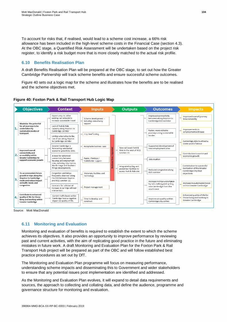
Mott MacDonald | Foxton Park and Rail Transport Hub 104 Strategic Outline Business Case
396964-MMD-BCA-XX-RP-BC-0003 | February 2019
To account for risks that, if realised, would lead to a scheme cost increase, a 66% risk
allowance has been included in the high-level scheme costs in the Financial Case (section 4.3).
At the OBC stage, a Quantified Risk Assessment will be undertaken based on the project risk
register, to identify a risk budget more that is more closely matched to the actual risk profile.
6.10 Benefits Realisation Plan
A draft Benefits Realisation Plan will be prepared at the OBC stage, to set out how the Greater
Cambridge Partnership will track scheme benefits and ensure successful scheme outcomes.
Figure 40 sets out a logic map for the scheme and illustrates how the benefits are to be realised
and the scheme objectives met.
Figure 40: Foxton Park & Rail Transport Hub Logic Map
Source: Mott MacDonald
6.11 Monitoring and Evaluation
Monitoring and evaluation of benefits is required to establish the extent to which the scheme
achieves its objectives. It also provides an opportunity to improve performance by reviewing
past and current activities, with the aim of replicating good practice in the future and eliminating
mistakes in future work. A draft Monitoring and Evaluation Plan for the Foxton Park & Rail
Transport Hub project will be prepared as part of the OBC and will follow established best
practice procedures as set out by DfT.
The Monitoring and Evaluation Plan programme will focus on measuring performance,
understanding scheme impacts and disseminating this to Government and wider stakeholders
to ensure that any potential issues post implementation are identified and addressed.
As the Monitoring and Evaluation Plan evolves, it will expand to detail data requirements and
sources, the approach to collecting and collating data, and define the audience, programme and
governance structure for monitoring and evaluation.

Mott MacDonald | Foxton Park and Rail Transport Hub 105 Strategic Outline Business Case
396964-MMD-BCA-XX-RP-BC-0003 | February 2019
The GCP Executive Board will need to agree this plan as part of the ‘sign-off’ process and
ensure that subsequent evaluation is undertaken in line with guidance, and will have a role in
the scrutiny and review of findings.
The GCP will publish an initial report based on data collected at least one-year post scheme
opening, and a final report based on further data collected approximately five years after
scheme opening. The results of the evaluation will be independently reviewed and will be made
available including publication on the relevant website.
6.12 Management Case Summary
• This preliminary Management Case includes an indicative programme, and commentary on
governance, quality assurance, communications, and risk management.
• The scheme is being promoted and managed by the Greater Cambridge Partnership,
applying a consistent governance and reporting structure to other schemes. On completion,
it is expected that the new Park & Rail site will be managed by Cambridgeshire County
Council.
• The scheme will pass through three business cases stages, of which this SOBC is the first.
Approval to progress to the next business case stage is a key decision taken by the Greater
Cambridge Partnership Executive Board.
• The constituent members of the Greater Cambridge Partnership have an extensive record of
successful public transport scheme delivery, including five successful Park and Ride sites.
• An indicative programme has been prepared, with the OBC due for completion in the
summer 2019 (following public consultation), followed by final option approval and then
detailed design completion by the middle of 2022. Construction is anticipated for 2023 (This
is subject to the relevant approvals being given by GCP Executive Board).
• A Consultation Plan has been prepared for the SOBC and OBC phases and will remain as a
live document. Non-statutory stakeholder engagement and public consultation will be
undertaken throughout scheme development.
• A risk register has been prepared, which identifies 53 risks (as at November 2018). The risk
register will be reviewed and updated as the project progresses. A Quantified Risk
Assessment will also be undertaken at OBC stage to improve cost estimate accuracy.
• Draft Benefits Realisation and Monitoring and Evaluation Plans will be prepared at OBC
stage.

Mott MacDonald | Foxton Park and Rail Transport Hub 106 Strategic Outline Business Case
396964-MMD-BCA-XX-RP-BC-0003 | February 2019
Appendices
A. Options Assessment Report 107
B. Park & Ride Demand Forecasting Technical Note 108
C. Consultation Plan 109
D. Record of Stakeholder Engagement 110
E. Appraisal Summary Table 111
F. Risk Register 112

Mott MacDonald | Foxton Park and Rail Transport Hub 107 Strategic Outline Business Case
396964-MMD-BCA-XX-RP-BC-0003 | February 2019
A. Options Assessment Report

Mott MacDonald | Foxton Park and Rail Transport Hub 108 Strategic Outline Business Case
396964-MMD-BCA-XX-RP-BC-0003 | February 2019
B. Park & Ride Demand Forecasting
Technical Note

Mott MacDonald | Foxton Park and Rail Transport Hub 109 Strategic Outline Business Case
396964-MMD-BCA-XX-RP-BC-0003 | February 2019
C. Consultation Plan

Mott MacDonald | Foxton Park and Rail Transport Hub 110 Strategic Outline Business Case
396964-MMD-BCA-XX-RP-BC-0003 | February 2019
D. Record of Stakeholder Engagement

Mott MacDonald | Foxton Park and Rail Transport Hub 111 Strategic Outline Business Case
396964-MMD-BCA-XX-RP-BC-0003 | February 2019
E. Appraisal Summary Table

Mott MacDonald | Foxton Park and Rail Transport Hub 112 Strategic Outline Business Case
396964-MMD-BCA-XX-RP-BC-0003 | February 2019
F. Risk Register

Mott MacDonald | Foxton Park and Rail Transport Hub 113 Strategic Outline Business Case
396964-MMD-BCA-XX-RP-BC-0003 | February 2019
mottmac.com