FORTRESS PYRAMIDS OF LUNA - nebula.wsimg.com
6
FORTRESS PYRAMIDS OF LUNA © Composition & Some Graphics by Luis B. Vega [email protected] www.PostScripts.org FOR ILLUSTRATION PURPOSES ONLY MOON PYRAMID STRUCTURES Lunar Cies? The purpose of this illustraon is to touch-upon the noon that there could be genuine pyramids on the Moon as they are on Earth. Specific to the Moon, it has been researched that the last lunar landing program, at least publically was Apollo 17. It was back in 1972 that the 3-member crew was declared to be the ‘last manned Moon landing’. What is very unique about this last mission was that in the public imageries that were available, some researchers did come across an apparent ‘pyramid’ structure anomaly. The specific frame was AS17-135-20680HR.The picture was rather washed-out but with the modern enhancement tools now readily available with such soſtware as Photoshop, the contrasts and brightness levels can be enhanced to see what is ‘behind’ such canvas. What emerged was an apparent pyramid like structure. Of course the 3 NASA Astronauts are sworn to secrecy and such cannot publically affirm nor deny what they were taking a picture of, especially if it was a pyramid structure. OCEANUS PROCELLARUM MARE NUBIUM MARE HUMORUM TYCHO OCEANUS IMBRIUM MARE VAPORUM MARE CRISIUM MARE TRANQUILLITATIS MARE SERENITATIS MARE NECTARIS MARE FECUNDITATIS In modern mes, there have been new theories about such anomalies that have challenged the convenonal paradigm of the various world religions and accepted scienfic models. Many believe that when the Earth and the Moon were created, the Universe was already in place. Or as others would point out, there appears to be a ‘gap’ between the Biblical accounts of Genesis 1:1 and 1:2 as the wording in Hebrew denote a revamping. 27°31’54.50”N 27°50’41.21”W The Moon is an astronomical body that orbits planet Earth, being Earth's only permanent natural satellite. Wikipedia Radius: 1,079 mi Distance to Earth: 238,900 mi Age: 4.53 billion years Orbital period: 27 days Gravity: 1.622 m/s² Orbits: Earth The point being is that there could have been some sort of life and civilizaon before the crea- on of Humanity on Earth. Such ‘pyramid’ anomalies that are not becoming more common and ‘discovered’ by such advanced soſtware as GoogleMoon, could be the ancient remnants of a prior ‘Age’. Some Sources GoogleMoon NASA Archives http://www.hq.nasa.gov/alsj/a17/AS17-135-20680HR.jpg Wikipedia.com Apollo 17 AS17-135-20680HR
Transcript of FORTRESS PYRAMIDS OF LUNA - nebula.wsimg.com

FORTRESS PYRAMIDS OF LUNA
© Composition & Some Graphics by
Luis B. Vega [email protected]
www.PostScripts.org
FOR ILLUSTRATION PURPOSES ONLY
MOON
PYRAMID
STRUCTURES
Lunar Cities?
The purpose of this illustration is to touch-upon the notion that there could be genuine pyramids on the Moon as they are on Earth. Specific to the Moon, it has been researched that the last lunar landing program, at least publically was Apollo 17. It was back in 1972 that the 3-member crew was declared to be the ‘last manned Moon landing’.
What is very unique about this last mission was that in the public imageries that were available, some researchers did come across an apparent ‘pyramid’ structure anomaly. The specific frame was AS17-135-20680HR.The picture was rather washed-out but with the modern enhancement tools now readily available with such software as
Photoshop, the contrasts and brightness levels can be enhanced to see what is ‘behind’ such canvas. What emerged was an apparent pyramid like structure. Of course the 3 NASA Astronauts are sworn to secrecy and such cannot publically affirm nor deny what they were taking a picture of, especially if it was a pyramid structure.
OCEANUS PROCELLARUM
MARE NUBIUM
MARE HUMORUM
TYCHO
OCEANUS IMBRIUM
MARE VAPORUM MARE CRISIUM
MARE TRANQUILLITATIS
MARE SERENITATIS
MARE NECTARIS
MARE FECUNDITATIS
In modern times, there have been new theories about such anomalies that have challenged the conventional paradigm of the various world religions and accepted scientific models. Many believe that when the Earth and the Moon were created, the Universe was already in place. Or as others would point out, there appears to be a ‘gap’ between the Biblical accounts of Genesis 1:1 and 1:2 as the wording in Hebrew denote a revamping.
27°31’54.50”N 27°50’41.21”W
The Moon is an astronomical body that orbits planet Earth, being Earth's only permanent natural satellite. Wikipedia Radius: 1,079 mi Distance to Earth: 238,900 mi Age: 4.53 billion years Orbital period: 27 days Gravity: 1.622 m/s² Orbits: Earth
The point being is that there
could have been some sort of life
and civilization before the crea-
tion of Humanity on Earth. Such
‘pyramid’ anomalies that are not
becoming more common and
‘discovered’ by such advanced
software as GoogleMoon, could
be the ancient remnants of a
prior ‘Age’.
Some Sources
GoogleMoon
NASA Archives http://www.hq.nasa.gov/alsj/a17/AS17-135-20680HR.jpg
Wikipedia.com
Apollo 17 AS17-135-20680HR

A LUNAR ROAD ANOMOLY
© Composition & Some Graphics by
LUIS B. VEGA
www.PostScripts.org
FOR ILLUSTRATION PURPOSES ONLY
Some Sources
GoogleMoon
Wikipedia.com
ARTISTIC RENDITION OF LUNCAR MINING ’LINES’.
Mining Lines? Ancient Evidence of
Mining Operations?
27°09’09.83”N 6°37’53.03”E
Lunar Road?
What this study has uncovered is that in the scanning of the various structure anomalies at the edge of the photographic strip across the face of the Moon, one did come across what appears to be a road. It is rather long over several mins in the general direction of north to south directions. It protrudes from the fuzzy gray overlay and onto the tapestry of the photo strip where it is clearly noticeable. Some may argue that this ‘line’ is just that, made by either the splicing of the photographs but no clear and
Could such a ‘line’ be a road that the forms prior to what the Moon has become were used for travel of some sort or of the transportation of materials, etc.? The line is too ‘straight’ to have been made naturally. It is reminiscent the Nazca Lines of Peru. The following coordinate is where the ‘Lunar Road’ can be located on GoogleMoon and hereby deemed ‘The Way of Vega’. Or plainly the Vega Line as it does not appear to have already a designated nomenclature.
The ‘Line’ or ‘Road’ is near the Apollo 15 Extravehicular activity documented
surveys. It is approximately 88 km from the ‘Road’ or 54 miles away with an
approximate 68 degree heading. The line or road itself is approximately 18 km in
length before it appears to despite or terminate at about the 10 mile marker.
The line or ‘road’ is approximately between the Sea of
Serenity and the Oceanus Imbrium.
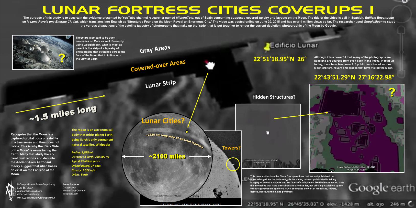
LUNAR FORTRESS CITIES COVERUPS I
© Composition & Some Graphics by
Luis B. Vega [email protected]
www.PostScripts.org
FOR ILLUSTRATION PURPOSES ONLY
Some Sources
GoogleMoon
MisteroTotal Channel
Wikipedia.com
The purpose of this study is to ascertain the evidence presented by YouTube channel researcher named MisteroTotal out of Spain concerning supposed covered-up city grid layouts on the Moon. The title of the video is call in Spanish, Edificio Encontrado
en la Luna Revela una Enorme Ciudad, which translates into English as ‘Structures Found on the Moon Reveal an Enormous City.’ The video was posted online on June 20, 2015 and has over 1 million views so far. The researcher used GoogleMoon to study
the various divagations of the satellite tapestry of photographs that make up the ‘strip’ that is put together to render the current depiction, photographic of the Moon by Google.
Lunar Cities?
22°51’18.95”N 26°
22°43’51.29”N 27°16’22.98”
Hidden Structures?
The Moon is an astronomical
body that orbits planet Earth,
being Earth's only permanent
natural satellite. Wikipedia
Radius: 1,079 mi
Distance to Earth: 238,900 mi
Age: 4.53 billion years
Orbital period: 27 days
Gravity: 1.622 m/s²
Orbits: Earth
Although it is a powerful tool, many of the photographs are
aged and are sourced from even back in the 1960s. In total up
to day, there have been over 113 public launches of various
Moon orbiters, rovers and probes that have visited the Moon.
This does not include the Black Ops operations that are not publicized nor
acknowledged. As the technology is becoming more sophisticated in taking
imagery of celestial objects and surfaces of such places like the Moon, so too have
the anomalies that have transpired and are thus far, not officially explained by the
various government agencies. Such anomalies consist of monoliths, towers,
domes, bases, tunnels, and pyramids.
Recognize that the Moon is a
captured orbital body or satellite
in a true sense and thus does not
rotate. This is why the ‘Dark Side
of the Moon’ is never facing the
Earth. Many that study the an-
cient civilizations and dab into
the Ancient Alien Astronaut
theory suggest that Alien bases
do exist on the Far Side of the
Moon.
These are also said to be such
anomalies on Mars as well. Presently
using GoogleMoon, what is most ap-
parent is the strip of a tapestry of
photographs that stretches across the
face of the Moon that in in line with
the view of Earth.
Towers?
LUNAR FORTRESS CITIES COVERUPS II
© Composition & Some Graphics by
Luis B. Vega [email protected]
www.PostScripts.org
FOR ILLUSTRATION PURPOSES ONLY
Some Sources
GoogleMoon
MisteroTotal Channel
Wikipedia.com
Then there are all those decade-long accounts of remote viewing, astro-projection and dreams that people have had to corroborate the notion that Aliens are working with humans to some capacity on the Dark Side of the Moon. Dr. Eric Norton is one
such brave soul that decided to risk his own safety and reveal some information about the things has seen while working for over 10 years in a government project monitoring the alien moon base. According to him, there's an alien base located on the
dark side of the moon. The secrets and the conspiracies of the Moon involve the whole spectrum of notions from 21 mile high towers to the Moon being a digital hologram. It is believed by many that at one time in the far distant past, the Moon, as was
Mars in particular there were mining operations where various elements were extracted.
Lunar Cities?
22°51’18.95”N 26°45’35.03”
22°39’08.29”N 27°14’35.09”
73°24’12.11”S 143°43’22.24”W
Perhaps it was to make their galactic ships or shining vehicles or the instrumentation needed for navigation and propulsion, etc. Concerning this study, the researcher MisteroTotal specifically honed-in to the edges of the long strip of the tapestry of images construed by NASA/GoogleMoon. Amazing, the researcher found that on numerous segments of the edges, there appear to be overlapping ‘structures’ or buildings that stick-out of the delineated photo overlays. There appears to have been a general ‘fuzzy’ layer of the topography of the Moon scanned and imaged but certain strips are enhanced and such detail is more revealing, especially as it meshes-up against these said respective border lines. What is anomalous is that there appears to be an attempt to ‘cover-up’ certain sections that appear to be buildings as they are ether square or rectangular in shape with either a black or white-out feature.
Apparent geometric configuration
of structures. It could be an effect
of pixilation.
Cover-Ups?

LUNAR FORTRESS CITIES COVERUPS III
© Composition & Some Graphics by
Luis B. Vega [email protected]
www.PostScripts.org
FOR ILLUSTRATION PURPOSES ONLY
Some Sources
GoogleMoon
MisteroTotal Channel
Wikipedia.com
In other cases, certain strips are blurred-out instead. The question comes-up, is this deliberate? Why? Why such a spotty workmanship in covering-up such structures? Did NASA not anticipate that perhaps one day the common mana and woman could ‘zoom-in’ on the lunar surface as one now is accustomed to zoom-in on a Google Street view? Is it the case that as there are too many objects to ‘cover-up’ by NASA, the work has just been left as it is presently and with no explanations given or to be?
It does appear that the areas for example just north of the strip of the tapestry of clearer topography has been intentionally ‘blurred-out’. Even in the 1960s, cameras from space or even those orbiting the Moon could pick-up contrasts and shapes. NASA does doctor images as many individual witnesses have come out publically to testify that certain images have been altered to exclude such anomalies as flying UFOs, bases, structures such as pyramids.
Lunar Cities? 22°46’38.06”N 27°50’52.05”
NASA Employee Leaves Top Secret Photos Of Base On Moon On Desk While Press Takes Photo 2012, UFO Sighting News.
Cover-Ups? The main thereat of such revelation
would be to the organized religions and
institutions that have a vested interest
in keeping the ‘Sheeple’ dumped-down
and in a trance to control them. If life,
of some sort existed or even does to
this day on the Moon and Mars for
example, this put the whole Darwinian
‘evolutionary’ paradigm in disrepute
and of a grave fallacy.
Many believe the governments are
not divulging such information to the
public because it would cause mass
panic or hysteria.

LUNAR FORTRESS CITIES COVERUPS IV
© Composition & Some Graphics by
Luis B. Vega [email protected]
www.PostScripts.org
FOR ILLUSTRATION PURPOSES ONLY
Some Sources
GoogleMoon
MisteroTotal Channel
Wikipedia.com
This of course provides more intrigue for researchers to find out what is behind such grayed-out surfaces. This is what MisteroTotal did using Photoshop. He took various screenshots of the areas just adjacent the various black and white-outs. Using the brightness/contract function with filters, he was able to decipher geometric square and rectangle patterns underneath the gray layer of the Moon’s surface.
Lunar Towers?
The highlighted strip on the face of the Moon is over 1000 miles across. What is unique about this tapestry of composite photographs of the Moon’s surface is that not all of the ‘grayed-out’ areas contain the blacked-out or whiteout cover-ups or smudges. Now it could be a matter of optical illusions as layers are placed upon each other in photographic segments that could produce such edges that appear to stick out. However some anomalies of said structures are so profound that the black-outs are beyond the
reasonable doubt of a cover-up. There are instances where the black-outs extend for several miles and appear to cover-up as it were vital imagery that is not meant to be seen.
27°39’58.40”N 2°16’17.27”3E
Lunar Cities?
Metallic Buildings Found In Tycho Crater In NASA Photos Tycho is a prominent lunar impact crater located in the southern lunar highlands, named after the Danish astrono-mer Tycho Brahe. To the south is the crater Street; to the east is Pictet, and to the north-northeast is Sasserides. Wikipedia
TYCHO
Cover-Ups?