FORT TANJONG KATONG RAISING HISTORY PLANTING ROOTS PROJECT · FORT TANJONG KATONG RAISING HISTORY...
30
FORT TANJONG KATONG RAISING HISTORY PLANTING ROOTS PROJECT Preliminary Site Report version 1.2 Report by Lim Chen Sian on behalf of the Archaeology Team [email protected] Project Overview The Mountbatten Citizen’s Consultative Committee (CCC) approached the archaeology team in August 2004 with the proposition of conducting an archaeological project at the site of the former Fort Tanjong Katong in Katong Park. Initial interviews and site assessment indicate the feasibility of conducting an archaeological project under the aegis of the Mountbatten CCC. In principle approval for archaeological investigations on the grounds of Katong Park was granted on 17 th September 2004 and archaeologists and volunteers commenced work on 29 th September 2004. The archaeological field work at Katong Park comprise of two field seasons; 2004 Season (29 th September – 20 th December) and 2005 Season (4th February – 30 th May). Archaeological Research Progress The archaeological investigations, archival research and post-excavation analysis took form in the following phases and time line: Phase 1: Site Assessment & Evaluation Early September 2004 This phase involves the initial physical site assessment, preliminary background research to the land usage and history, and evaluation of the archaeological potential of the site. This phase was completed in part with two ground surveys by Mr. Jack Sim (Fort Road resident), Mr. Lim Chen Sian (archaeologist, NUS SEASP MA Candidate) and Dr. Edward McKinnon (archaeologist, NUS Asia Research Institute) on the 1 st and 4 th September 2004 ; and background archival and historical text research on Fort Tanjong Katong. Ground surveys consist of trowel probes and measurements of visible structural remains that may be the foundations or part of the defensive works. Background archival research on the fort and the environs continues concurrently with the later phases. Phase 2: Magnetometer Survey & Soil Coring 29 th Sept 2004 – 30 th April 2005 Soil coring test with the use of a hand auger (the auger bucket measures five centimeters in diameter) can provide much needed data on subsurface stratigraphy and highlight potential archaeological reservoirs. For a sufficient sampling procedure, core tests at 5 or 10 meters intervals along an axis/transect are conducted. A magnetometer survey of the site is conducted to explore for evidence of subsurface features, remains and soil patterns. Magnetometry is a non-intrusive method of reading the earth’s magnetic field beneath the surface. Magnetometer tests records variances and distortions of the earth’s magnetic field when an object obstructs the flow of magnetic pulse. A buried object or in this case, the remaining structure of the fortification can be mapped out employing this technique. The site datum is arbitrary selected as the southeast corner of a utility manhole, south of the southeast bastion (N 01°17’ 809” E 103° 53’ 203”) 1) Subsurface Coring Test – In the 2004 field season, two transects were laid along the locality of the suspected eastern inner moat wall of the fort, and coring was conducted along the transects at every 10m intervals. Supplementary coring tests were conducted during later phases of the project near test units with the intention of assessing the benefit to be obtained either by extending extant pits or opening up additional pits. At the point of writing a total of six transects are set up for the entire site: TNS 1: North-south from the site datum TEW 1: East-west at TNS 1(50m) TNS 2: 36m west of datum TEW 2: 70m north of datum TEW 3: 27.4m north of datum SHiEN
Transcript of FORT TANJONG KATONG RAISING HISTORY PLANTING ROOTS PROJECT · FORT TANJONG KATONG RAISING HISTORY...

FORT TANJONG KATONG RAISING HISTORY PLANTING ROOTS PROJECT Preliminary Site Report version 1.2 Report by Lim Chen Sian on behalf of the Archaeology Team [email protected] Project Overview The Mountbatten Citizen’s Consultative Committee (CCC) approached the archaeology team in August 2004 with the proposition of conducting an archaeological project at the site of the former Fort Tanjong Katong in Katong Park. Initial interviews and site assessment indicate the feasibility of conducting an archaeological project under the aegis of the Mountbatten CCC. In principle approval for archaeological investigations on the grounds of Katong Park was granted on 17th September 2004 and archaeologists and volunteers commenced work on 29th September 2004. The archaeological field work at Katong Park comprise of two field seasons; 2004 Season (29th September – 20th December) and 2005 Season (4th February – 30th May). Archaeological Research Progress The archaeological investigations, archival research and post-excavation analysis took form in the following phases and time line: Phase 1: Site Assessment & Evaluation Early September 2004 This phase involves the initial physical site assessment, preliminary background research to the land usage and history, and evaluation of the archaeological potential of the site. This phase was completed in part with two ground surveys by Mr. Jack Sim (Fort Road resident), Mr. Lim Chen Sian (archaeologist, NUS SEASP MA Candidate) and Dr. Edward McKinnon (archaeologist, NUS Asia Research Institute) on the 1st and 4th September 2004 ; and background archival and historical text research on Fort Tanjong Katong. Ground surveys consist of trowel probes and measurements of visible structural remains that may be the foundations or part of the defensive works. Background archival research on the fort and the environs continues concurrently with the later phases. Phase 2: Magnetometer Survey & Soil Coring 29th Sept 2004 – 30th April 2005 Soil coring test with the use of a hand auger (the auger bucket measures five centimeters in diameter) can provide much needed data on subsurface stratigraphy and highlight potential archaeological reservoirs. For a sufficient sampling procedure, core tests at 5 or 10 meters intervals along an axis/transect are conducted. A magnetometer survey of the site is conducted to explore for evidence of subsurface features, remains and soil patterns. Magnetometry is a non-intrusive method of reading the earth’s magnetic field beneath the surface. Magnetometer tests records variances and distortions of the earth’s magnetic field when an object obstructs the flow of magnetic pulse. A buried object or in this case, the remaining structure of the fortification can be mapped out employing this technique. The site datum is arbitrary selected as the southeast corner of a utility manhole, south of the southeast bastion (N 01°17’ 809” E 103° 53’ 203”) 1) Subsurface Coring Test – In the 2004 field season, two transects were laid along the locality of the suspected eastern inner moat wall of the fort, and coring was conducted along the transects at every 10m intervals. Supplementary coring tests were conducted during later phases of the project near test units with the intention of assessing the benefit to be obtained either by extending extant pits or opening up additional pits. At the point of writing a total of six transects are set up for the entire site: TNS 1: North-south from the site datum TEW 1: East-west at TNS 1(50m) TNS 2: 36m west of datum TEW 2: 70m north of datum TEW 3: 27.4m north of datum
SHiEN 1

TNS 3: 120m west of datum All bore holes were immediately backfilled and remains unobtrusive. Coring tests revealed much secondary fill material comprising of clay and sand that were deposited after the abandonment of the fort. The stratigraphic layers of the site are generally uniform and consist of modern tuff and sod at the top (surface to 10cm below surface) followed by a thick layer of yellow/orange compact clay (10 – 90 cmbs), coarse to fine sand (90 – 200cmbs), and the water table at approximate 200cmbs. Variations in stratigraphy appears mainly in the locality of the southeast bastion and caponier passage (corridor leading into bastion), where an additional thick layer of dense fill material is deposited. Also, recent disturbance with the construction of the reflexology footpath and other park amenities resulted in a layer of yellow large grain sand deposited in the immediate vicinity of such features. Soil samples were collected for the coring tests as well as specific excavation test pit units. The want of geological expertise has delayed the analysis of the samples and at present only a preliminary descriptive of the soils can be made. 2) Magnetometer Test, Survey and Mapping – Measurements of the site's subsurface magnetic anomalies have been conducted through magnetometer tests in hopes to identify structural outlines that are not visible and remained in situ and undisturbed from modern development at the park. The tests were conducted from the months of December 2004 through January 2005. Three grids of 20m x 20m were laid out and readings were obtained at every 1m intervals. The test grids were randomly distributed across open areas of the site, where no park features, trees are other botanical intrusions are situated above ground. Two test grids were conducted on the western half of the park in the open area south of the identified drawbridge superstructure. A third test grid was set up north of the southeast bastion where the caponier passageway (and later educational pits FTK46-60) lies. Due to the age of the magnetometer test machine, part of the data upon downloading for computer analysis were corrupted and results from the magnetometer test are still pending repairs of the magnetometer reader unit and hence inconclusive at this point of writing. Phase 3: Test Pit Excavations 29th September 2004 – 30th May 2005 Base on soil coring surveys, test pit excavations were conducted in the potential archaeological deposit areas highlighted in Phase Two. Each test pit is uniformly set as 2x1m in size. The depth of the excavations was determined by the level of the water table or obstruction by rubble. Given that the site was located on the edge of the former shoreline of Singapore before land reclamations of the East Coast, resulted in a high water table mark of between 150cm and 200cm. Supplementary excavations include Shovel Test Pits of 1x1m, conducted during the closing months of the project in 2005. In addition, the top soil of identifiable or suspected fort remains was removed in the western half of the park disclosing the western moat escarp perimeter and the southwest bastion. Phase Three of the project saw the involvement of large numbers of local resident volunteers and students. 1) Test Pit Excavations – Two 2x1m test trench (FTK 1 and 2) were excavated at the suspected northeast corner of the fort inner moat wall. To date, twenty-two 2x1m test trenches (FTK 5-22, 30, 33-36) were opened to expose the prominent southeast horseshoe shaped feature. The archaeologists believe this feature to be a bastion, a defensive feature of fortification architecture to protect the corners of a wall or moat, enabling the defenders to bring fire upon the flanks of attacking forces assaulting the walls. The main area of excavation for 2004 season was primarily concentrated on the southeast bastion feature. Stratigraphic profile of this feature comprise of modern tuff and sod on at the top (surface to 10cmbs), compact layer of yellow/orange clay (approx.10 – 30cmbs), followed by a black layer of construction fill midden (refuse) material (30 – 110cmbs), and fine marine
SHiEN 2

sand (110 – 150cmbs). The construction fill material was the result of the land reclamation project of the East Coast in the late 1960s where the shoreline bordering the park was obliterated and leveled out. Five 2x1m test pits (FTK 23, 24, 25, 28 and 29) were excavated across the suspect east moat, which historical records indicate to be 100ft wide. The moat trench excavation is directed at recovering any artifacts which may have been discarded in the body of water during the occupation period of the fort as well as to provide a profile of the stratigraphy of sediment deposits. Additional test pits were opened to explore the other corners of the fort, chiefly in the suspected vicinity of the drawbridge (FTK 26, 27, 31, 32, 38 and 39). The water table at FTK 27 is higher at 160cmbs due to the lower elevation on the northern half of the site. The footing of the wall in FTK 27 is found to be around 210cmbs. Three 2x1m test pits (FTK 37, 40, 41) were sunk into the suspected region of the fort’s underground magazine situated between the gun emplacements. These pits were excavated to approximately 70cmbs, and a coring test conducted within the pits to 220cmbs, the water table reading at 200cmbs. No evidence of the magazine remains is found. The 2005 field season saw a further 40 2x1m test units opened, sixteen (FTK 45-60) of which are dedicated as education pits for the influx of student volunteers. FTK 45-60 is situated over the caponier passageway leading into the southeast bastion. The majority of the remaining test pits were sunk to explore for remains of the fort’s interior; FTK 42 north of the fitness center; FTK 63, 64, 69 and 78 west of the playground; FTK 66, 67, 76 and 77 west of improvised soccer pitch. These test pits proved to be sterile of 19th century cultural remains from the fort. Approximate depth of excavation is 40cmbs where either rubble was uncovered and the unit abandoned, or a coring test was conducted within the unit to ascertain sterility. Several rubble fields were investigated; FTK 61 and 62 adjacent to the unexcavated southwest bastion, and FTK 70-75 at the end of the caponier passageway leading to the southwest bastion. Dense concentration of rubble resulted in these pits being abandoned. The few test pits that revealed more of the fort’s structure are; FTK 43 and 44 at the corner arm of the moat escarp northwest of the drawbridge superstructure; FTK 79 the northern mate of the drawbridge superstructure; and FTK 80 east of the playground where an yet unidentified L-Shaped structure remains in situ covered by rubble. To date a total of 80 test pits were conducted. All the test trenches are cordoned with either fencing or safety tapes, and signs are posted as warning of archaeological works in progress. 2) Supplementary Excavations and Shovel Test Pits – A total of twenty 1x1m random shovel test pits were conducted in the eastern half of the park where the improvised soccer pitch is located. The shovel test pits were dug to a depth of approximately 35cmbs revealing mainly sand deposits. In addition to the shovel tests, the western half of the park saw the removal of the top soil and sod, exposing the entire western moat escarp perimeter, southwest bastion and the connecting caponier passageway. The depth of the top soil removed is between 5-15cmbs. No further excavations are however conducted on these exposed features due to constraints in time and resources. Phase 4: Large Scale Excavations No large scale excavations were conducted at the site and excavations have been limited to individual or multiple test pits of 2x1m in nature. Phase 5: Post Excavation Research & Analysis 15th April 2005 - Present The analysis of the uncovered artifacts and ecofacts, archival research on military architecture, social norms and life during the colonial period, as well as the local history and heritage of the area is presently underway. Such extensive research program with archival,
SHiEN 3

library and laboratory analysis is necessary in the development of a site display corner. The processing of the artifacts were either conducted on site or at the facility provided at Katong Community Club. This phase also saw the active involvement of students and other volunteers. 1) Post Excavation Artifacts Processing & Analysis – Artifacts recovered from an archaeological excavation requires proper processing involving washing, cleaning, sorting and cataloging prior to the any actual study and analysis of the material. The general rule of thumb for archaeological work equates one day of field work excavations to one week of post excavation processing. At the point of writing, initial processing of the 2004 season materials and 2005 test pits (excluding education pits FTK 45-60) have been completed which entailed the washing and preliminary sorting of the artifacts. A preliminary breakdown of the artifacts as follows: Ceramics (porcelain, earthenware & stoneware) – 2 crates (60x30cm) Ceramics (stoneware flowerpots) – 250kgs + 5 gurney sacks (not weighed) Glass (bottles and various types) – 4 crates (60x30cm) Coral & Ecofacts – 3 crates (60x30cm) Metals (nails, scrap etc) – 4 crates (60x30cm) Brick & Building Material Samples – approx. 100kgs Miscellaneous (plastics, household items etc) – 3 crates (60x30cm) Soil Samples – 1 crate (60x30cm) Analysis of the artifacts have not progress beyond the processing stage, however 36 bags of the coral and ecofacts are undergoing identification and study by Professor Chou Loke Ming and his marine biology team at the Raffles Museum of Biodiversity Research, National University of Singapore. 2) Archival Research – Much of Fort Tanjong Katong’s past is unknown, and a few scarce references are found in secondary texts. Archival research takes the form of reviewing secondary sources on the military history of Singapore, fortification studies, colonial administration, and general history of the late 19th century period in Singapore, the region and the British Empire at large. Primary sources in the likes of examining Colonial Office and War Office correspondences, the Straits Settlements records, period newspapers and maps held in the collections of the National Archives of Singapore, National University of Singapore Libraries, National Library Singapore, SAFTI Military Institute Library, British Library London, and National Archives (formerly Public Records Office) Kew United Kingdom. In addition, inquires were also made with the Urban Redevelopment Authority, Housing Development Board, Singapore Land Authority, Sentosa Development Corporation, Singapore History Consultants, Royal Artillery Museum London, Palmerston Forts Society United Kingdom, the Fortress Study Group United Kingdom, as well as a multitude of individual specialists in the fields of archaeology, military history, fort studies, and Victorian period history. A weeklong archival study trip to London’s archival depository at the British Museum and British Library was made during the month of February 2005 by Mr. Lim Chen Sian. Archival research work was assisted by numerous volunteers and well-wishes, primary Ms. Foo Shu Tieng, Mr. Noel Hidalgo Tan, and University Scholars Programme National University of Singapore/Singapore Heritage Society (USP NUS/SHS) interns. At present, archival research is still underway. Phase 6: On Site Heritage & Archaeology Exhibits Pending Previously referred to as Phase 5 in the initial project proposal (dated September 2004) and Progress Report of November 2004, this final phrase describes the development of on site interpretive displays and exhibits of the historical and archaeological significance of the site as well as to showcase any artifacts uncovered during excavations. The extent of which the on site interpretive displays is to be developed will be contingent on the finds uncovered. This
SHiEN 4

phase may take the form of simple explanatory signs on the history and archaeology of the site, to an exhibition station highlighting archaeological finds, to a complete gallery and interpretative visitors’ center starting visitors off to various heritage and cultural sites in the Katong district. The Fort Canning archaeology interpretative site is a useful model for reference. This phase is pending negotiations pertaining to the continuation of the project under potential host-partners. Preliminary Findings General History of the Fort Defense has always been the priority of any settlement, and the establishment of an East Indian Company factory on the island of Singapore was no different. Fort Tanjong Katong was part of the series of late 19th century works that were constructed during the general fort building exercise of the 1850s, 60s and 70s. 1
The earliest reference to the construction of defensive works in the Tanjong Katong area was Thomas Stamford Raffles’ instructions to the first Resident and Military commander of Singapore, Major William Farquhar dated 6th February 1819. Raffles wrote, “Along the coast in the vicinity of the Settlement one or two strong batteries for the protection of the shipping and at Sandy Point a redoubt and to the east of it a strong battery for the same purpose.” 2 – east of Sandy Point was the stretch of beach near Kallang River basin, possibly the present day indoor stadium and Marine Police HQ. However no batteries or defensive works were built that far east, and the only gun battery remained in the initial years at Scandal Point (the vicinity of the former Satay Club, southeast of St. Andrew’s Cathedral). Raffles left Singapore without seeing any of the defensive works he envisioned constructed (apart from the battery placed at Scandal Point and the fieldworks set up by the sepoys around the area of Fullerton (which incidentally in the 1830s became Fort Fullerton). Raffles was not the only person to propose constructing works at Sandy Point and east of it. In 1827, Captain Edward Lake of the Bengal Engineers surveyed and proposed new defensive works for Singapore. He advocated an elaborate scheme for Singapore's defense, incorporating a fortress with a vaulted chamber inside the wall (a case mated redoubt) south of the Singapore River mouth, another similar fort at Tanjong Katong, on a spit of land at the entrance to the Kallang Basin then called Sandy Point, and three other batteries in between the two forts along the shore. Again, this proposition was not carried out for various reasons and remained unexecuted. 3
It appears that in each following decade a new survey of Singapore’s defenses was made and in 1843 Captain Samuel Best was dispatch from Madras to assess the defenses where he concurred with the earlier proposal of Lake. In August 1853, Lt. Henry Yule of Bengal Engineers was detached to compile another study of the Singapore situation and he recommended that Singapore be defended by four batteries: at Fullerton, Mount Palmer, Tanjong Katong, and Mount Faber. Yule also reported that the defensive work proposed at Tanjong Katong had not been undertaken because the sandy soil at the site was thought unsuitable by the Governor Straits Settlement. 4
The Crimean War, which began in 1854, saw a Russian naval squadron entering the South China Sea, calling at Manila and Batavia, and causing much alarm in Singapore for only one British naval vessel, the sloop HM Rapid was present in the Straits of Melaka at the time. Yet ten years later, the eastern approach to New Harbour still lay undefended. In 1864 the local defense committee urged that the long contemplated Tanjong Katong battery be constructed. 1 Fort Canning and Fort Palmer were constructed in the 1850s; the 1860s saw the rise of Fort Faber and Fort Teregah; 1870s Fort Pasir Panjang, Fort Siloso, Blakan Mati East, Serapong and Tanjong Katong. Appendix 1 of “Between Two Oceans: A military history of Singapore” provides a brief list of the forts and their history. Also Harfield pp.292-305. 2 Murfett et al, pp.45. 3 Ibid, pp.56. 4 Ibid, pp.59-64.
SHiEN 5

The governors asked that the aging Fort Fullerton be disposed of, its land sold and the proceeds used to defray the cost of building Tanjong Katong Battery, and of improving Fort Palmer. 5
The decades of the 1860s and 70s saw growing Russian menace and British military strategy was influenced by Russian moves in Central Asia where they took Turkestan, Chimkeat in 1864, Tashkent in 1865, and Samarkand in 1868. In 1873 the Khanates of Khiva, and Burhara became Russian protectorates, and Kokand was annexed in 1876. The French too was a constant concern for the Empire, and it was pointed out that The French had 4,000 men in Cochin China, and were only 5 hours sailing from Singapore. 6
On 12 April 1877, Russia declared war on the Ottoman Empire and with the Russian army at his doorstep, the Ottoman Sultan sued for peace. Russia’s terms of peace dictated at San Stefano in March 1878 attempted to secure unrestricted right of passage for its Black Sea Fleet to the Mediterranean by demanding the creation of an independent Bulgaria stretching from the Black Sea to Aegean Sea. London refused to recognize the Treaty of San Stefano and began openly to prepare for war. 7
1875 saw Sir William Drummond Jervois late of the Department of Fortifications at War Office appointed Governor Straits Settlement. The new governor was considered by many as an expert in fortifications and suggested sweeping reforms for the defense of Singapore. He rightly pointed out to the Colonial Office in London that there were 70,000 tons of coal in the Singapore station but little defense was allocated for it - under Jervois, the construction of the gun battery at Tanjong Katong was to be. 8
In 1878, works were thrown up on Mount Siloso, Mount Blakan Mati, and at Tanjong Katong, all of which were designed and constructed by Lieutenant Henry McCallum of the Royal Engineers on loan from Hong Kong. Construction at Tanjong Katong of the battery proper started in March 1879 and was completed in September that same year. 9
In 1885 work began on upgrading the existing gun batteries in Singapore, and the three gun battery at Tanjong Katong was replaced with a pair of more powerful and longer range breech loading 8 inch guns. Modifications and additional fortifications were made to strengthen the position and the Tanjong Katong battery was elevated to the status of a Fort. 10
Advancement in military technology and lack of a military garrison to man the fort, along with the remoteness of the site for supplies and reinforcements, soon reduced the effectiveness of Fort Katong as a defense position. Barely 5 years have passed since the upgrading works were completed in 1888, were calls for Fort Katong to be abandoned and demolished. 11
The guns of Fort Katong were never once fired in anger, and its days were withered away except for the sporadic employment as a training camp for members of Singapore Volunteer Artillery (SVA). The debate to abandon the fort lingered on between the Colonial Defense Committee in London and the Local Defense Committee Singapore for about a decade and the fort was finally rendered obsolete and abandoned in 1901 with the removal of the guns, 5 Ibid, pp.91. 6 Ibid, pp.89 and 96. 7 Ibid, pp.98-99. 8 Dr. Sue Sutton’s report commissioned by the National Heritage Board’s Historical Sites Unit
in 2002. The NHB brief titled “Historical Background of Katong Fort” is an abridged version of Dr. Sutton’s original report, which excludes any reference source and even the identity of the researcher! The author is much obliged to Dr. Kevin Tan of the Singapore Heritage Society for assisting in tracking down Dr. Sutton, and grateful thanks must be made to Dr. Sutton for making available her original version of the report and entertaining the many inquiries. Dr. Sutton’s original report is titled “Tanjong Katong Fort, Singapore”, unless otherwise stated, references cited are from this original report. Sutton, pp.2. Also Admiralty Correspondence ADM 125/140
9 Sutton, pp.2. 10 Colonial Office Records CO 537/46/260, and CO 273/137/12970 11 Sutton provides details of the debate for the fort’s abandonment. Also CO 273/68/27368, and
CO 45/201/45201.
SHiEN 6

though the SVA may have continued to utilize the site as training grounds for its 10 pounder mountain guns, and maxim machine gun company. The fort was demolished sometime between 1906 and 1928 and eventually the site became a public park. Katong Park was first mentioned in the 1928 Straits Settlements Annual Report (SSAR) by Director of Gardens, Mr. R.E. Holttum indicating that a plan for the layout of the park has been submitted. It is not known when the approval for the park was granted and the next mention of the park was in the 1935 SSAR. A 1932 map depicting the Katong locality clearly demarcated the park, showing the bandstand, footpaths and public bathing enclosure by the sea. 12
During the Japanese Occupation (1942-45), the Japanese constructed mechanical testing bays at the park servicing the aircraft engines from Kallang airfield. The testing bays were then utilized as a rest shed for the park’s swimming enclosure during the post war years. 13
Although the site of the former fort became a public park, some elements of the fort can still be witness in the 1950s and 1960s. Photographs and Royal Air Force (RAF) aerial photographs of the park depicts outlines of the fort’s perimeter moat escarp, and southeast bastion overgrown with shrubbery. Maya Jayapal in her book Old Singapore on Katong Park writes, “the old fort which had intriguing moss-shrouded tunnels.” 14 To most lay people, any confined space, especially those of subterranean nature will no doubt be understandable referred to as “tunnels”. Archaeologically, no tunnel complex was uncovered at Fort Tanjong Katong and no indication of such tunnels is found from the 1885 plan for revision of the fort. Jayapal may be actually referring to the caponier passageways leading into the bastion, and as illustrated in the aerial photographs of 1965 and 1969 covered with shrubbery. A note should also be made on the reliability of eye-witnesses on identification of military features and subject matter. The commencement of the archaeology project brought forth many informants and their accounts of witnessing the fort in the 1950s-60s. Through the course of the interviews, it was discerned that many witnesses confused the fort with a series of structures across the road at the present site of the Waterfront apartment complex where until the 1980s, there were remains of probable military structures from the Second World War period. 15
Technical History 16
Fort Tanjong Katong had initially started off as a three gun battery consisting of 7" Rifled Muzzle Loader (RML) of 7 tons, possibly manufactured by Armstrong from 1879-1885 and mounted on dwarf carriages. The 7-ton gun was the smallest of the guns classified as Heavy RML. It was the smallest gun mounted for coast defense and could have been on either an A or C pivot mounting. These mountings differed in that the C pivot had a central pivot and the racers were circular. The 7” RML of 7 tons were only to be found at the Tanjong Katong battery. The rest of the forts at Pasir Panjang (today Labrador), Palmer, Siloso, and Blakan Mati East were all of the 7” RML 6.5 tons design. 17 Examples of this latter type, including a complete replica on its chassis can be seen at the Fort Siloso Gun Museum on Sentosa Island. 12 Much thanks to Mr. Jeyathurai and his team from Singapore History Consultants for providing
background on the history of the park. 13 Ibid. 14 Thanks to Mr. Noel Hidalgo Tan for alerting the author to this anecdotal reference. 15 Mr. Guo Nan Gun, local area resident kindly provided photographs of these features. See also
his article in the “Jiao Lu Ban, Lian He Zao Bao” 6th November 2004. A similar article appeared in “Sin Min Re Bao” back in 1988.
16 In this section, the author is indebted to Major Alan Harfield, Mr. David Moore (Palmerston Fort Society United Kingdom), Mr. Peter Stubbs, Mr. Charles Blackwood (Fortress Study Group United Kingdom), Mr. Matthew Buck (Royal Artillery Museum London), and Dr. Sue Sutton for their many correspondences via E mail and telephone, but most importantly their gracious sharing of their research and information. This section is a compilation of a selection of the relevant correspondences.
17 CO 537/46/362.
SHiEN 7

In 1885, the guns were replaced with a pair of 8" Breech Loader (BL, 8"/26 MkVII?) There are only two forts in Singapore equipped with this non-standard 8" BL guns, Forts Tanjong Katong and Serapong on Blakan Mati (today Sentosa Island). It is not clear what became of the battery of three 7” RML 7 tons from Tanjong Katong during the upgrading of the works into a fort. The 8” BL was not used in the defenses of the United Kingdom, but were used in the far flung outposts of the Empire in Singapore, Australia and New Zealand. The 8” BL is a throwback to the designs of the earliest 8" (20.3 cm) guns, with construction being of mixed steel and wrought iron construction. Four of these 26 caliber guns were purchased from the Armstrong plant at Elswick and eventually mounted at Singapore in long recoil barbette mountings. 18
On 31st December 1890, one of the 8" BL guns at Tanjong Katong burst on firing, blowing up its muzzle. No casualties were reported and an interesting note found in the accompany reports on this incident states "the damaged piece, which is one of th(ree...those? Writing illegible) purchased from the Chinese government.” The weapons were possibly on order by the Imperial Chinese Government of China during the Sino-French Wars of 1890s and somehow found it way to Singapore instead. 19 One of the surviving 8” BL gun barrel from Singapore remain on display at the Fort Siloso Gun Museum, whilst another piece can be found at the Royal Artillery Museum’s grounds at Rotunda, United Kingdom (No.3/242 Royal Artillery Catalog with the serial no.7278 incised on left trunnion along with 1890 date.) The Gunner, the magazine of the Royal Artillery, recorded the arrival of the gun in 1968. According to various correspondences, it was one of three decommissioned from Serapong and buried in the hill adjacent to the fort in 1913. Sometime between 1956-58 two pieces were disinterred and mounted as a memorial on the main parade square of Blakan Mati and that one was taken back to the UK in 1967-8. The location of the third gun (if it exists) remains unknown. 20
There is a remote possibility that either of the surviving barrels at Sentosa or the Royal Artillery Museum was originally from Tanjong Katong, for debate regarding the usefulness of Fort Tanjong Katong started early in the 1890s, and in about 1893 the War Office London, made no objection to demolishing Fort Tanjong Katong, "provided that the guns (by then the pair of 8" BL) were remounted at Fort Serapong or elsewhere". 21
Although archaeological investigations yielded little of the fort’s interior structures (gun emplacements, casemates, magazines, stores, barracks etc), the design of the fort is indubitably based on current military doctrines employed in the mid-late 19th century. Within the British army the 8-inch BL Armstrong gun was not part of the standard armament, therefore the manpower cover for these guns would have had to be adjusted locally to arrive at an agreed manning level. Each standard battery of the Royal Artillery had the following officers on its strength: 22
Major – 1 Captain – 1 Lieutenants - 2. The other rank establishment was based on the number of guns and gun emplacements which was calculated by the War Office as follows. Manning each 9.2 inch gun 1 officer and 30 other ranks. each 6 inch gun 1 officer and 35 other ranks. 18 E mail correspondence with Mr. Peter Stubbs. Stubbs served with the British Army stationed
in Singapore from 1965-68. 19 Colonial Office Records CO 273/172/2866. 20 E mail correspondence with Mr. Matthew Buck, Royal Artillery Museum London. See “The
Gunner” Vol.49 No.10, Vol.50 No.1, and Vol.50 No.7. Much thanks to Mr. Buck for these relevant articles.
21 Sutton, pp.6. 22 E mail correspondence with Major Alan Harfield. Winsley, pp.33. See also Harfield’s chapter
11 where he details the garrison order of battle for the Strait Settlements.
SHiEN 8

Accommodation for the men would require either one very large barrack room or, more probably in a fort of Tanjong Katong’s size, multiple smaller rooms with washroom and messing facilities. There would also be a requirement for accommodation for the officers. No archaeological remains of messing, latrine or the quarters have yet been uncovered, and it is believed that the demolition of the fort’s interior had been thorough. A photo of the SVA’s training at Fort Tanjong Katong dated c.1905 depicts tents and a thatched hut, and hence is also probable that permanent quarters were never constructed at the fort. The lascar sentries employed to guard the fort were also said to be accommodated in tents. 23
Albeit there is no archaeological finding to verify the following, it is likely that Tanjong Katong’s design was similar to other forts of the same time period, and the following description of the fort may be relevant. 24
The two 8-inch guns were on barbette mountings with two sets of cartridge and shells stores which were located between the two gun positions. The casemates had brick vaulting of 6 ft 6 inches high rising to 8 ft 6 inches in the centre. The cartridge stores had a dry area of two feet in width separating the store from the outer layer of concrete to prevent the cartridges getting wet. The dry areas were ventilated through the roof of the casemate, also to prevent damp. The floor of the casemate was of concrete, six inches thick, with two layers of asphalt to prevent moisture rising and damaging the cartridges. The roof of the casemate was sloped in one direction for drainage with a six-inch drain pipe to take away any surplus water. From the cartridge store bags of cartridge charges would have been brought out of the casemate and carried up a ramp to the loading platform. The shells, which were stored at the base of the ramp, would also have been taken by hand to the loading platform. However, hand operated mechanical hoist may be installed but this would have been added at a later date. The gun pit would have been two or three feet below the parapet level. The gun pits had an outside concrete 'shield' so as to prevent the gun flash from setting light to any grass or undergrowth. The front (or sea side) of the fort would have been covered with earth and planted in order to disguise the site from any hostile ship approaching the eastern roadway. A wet ditch or moat was provided for the fort defenses surrounding the entire battery. There was a bridge over the ditch which was located on the land side (Katong side). The bridge would have been defended by enfilade fire from infantry positions set up adjacent to the entrance and within the fort. According to the plan of 1885, there appears to be an infantry parapet and traverse running between the two main gun platforms, directly over the cartridge casemate. Barbed wire entanglement acting as a deterrent to any infantry attack from those sides as whilst trying to traverse the wire the enemy would come under fire from the troops within the fort, were also laid out around the perimeter of the fort. Archaeological Findings Much of Fort Tanjong Katong has since been demolished and the gun(s) were removed sometime around the turn of the 20th Century (c.1901). Archaeological remains of the fort have been limited to the perimeter moat escarp, drawbridge superstructure, a pair of bastions complete with glacis ramparts and caponier passageways. It appears that the demolition process were thorough and unlikely that any of the fort’s interior (gun emplacement, magazine stores, fire steps, infantry parapets etc) remains. Test pit excavations and coring tests conducted have revealed nothing of this interior. It is possible that sampling error may be the cause of the lack of findings; however it is more likely that developments over the last century at the site have eradicated much of the fort remains. In April 2002 a ground penetrating radar (GPR) survey was conducted by SETSCO for National Heritage Board’s Historical Sites Unit. 25 In the report submitted, SETSCO 23 Harfield, pp.330. Sutton, pp.5. Winsley, pp.30. 24 The following is complied from correspondences with Major Harfield, David Moore, and
Peter Stubbs.
SHiEN 9

technicians expressed similarities between the GPR findings and the 1885 proposed battery plan, however examination of the GPR results in September 2005 by the archaeologists did not reveal any additional useful information that is not already observable as features on the site’s surface. The GPR report primarily suggested the presence of suspected continuous slab/wall and localize metallic object, and concluded the necessity of ground-truthing through excavations to verify the geophysical survey. Coring and test pit excavations revealed a general clay deposition immediately beneath the top soil and sod. Beneath the clay, sand of varying degree of coarseness is found. Variations in the stratigraphy are generally limited to viscosity and thickness of the clay deposits. The fort structural remains consist mainly of the moat escarp, a pair of bastions and accompanying caponier passageways, the remaining perimeter of the fort measures approximately 64m in depth (north-south) and 98m wide (east-west). The southeast horseshoe-shaped feature has been identified as a bastion with the escarp walls featuring glass shards embedded atop to deter scaling of the inner moat walls. The bastion is itself protected by a circular glacis and rampart likewise embedded with glass shards. Strands of barbed wire are also recovered. From the 1885 plan for the proposed revision to the defensive works, it is not clear if the bastions were featured in the renovations. It can only be deduced that either the bastion was added in as an after-thought not reflected on the plan, or perhaps at a later date after the 1885 revisions to house the 8” BL armaments. The general excavation within the bastion consists of fill dated to the 1960-1970s period with large amounts of modern late 20th century debris, glass bottles, stoneware ceramics - mostly flower potsherds. This layer of fill was the result of Phase One of the East Coast Reclamation Scheme that was carried out between April 1966 to April 1970. The area that was reclaimed stretched from Bedok (near Bedok Army Camp) to the Singapore Swimming Club, just past the Katong Park area. What remains of the fort must have been buried during this reclamation project, as the old shoreline was leveled off and the new shoreline extended approximately 500m to 1km south. The contractor for the reclamation this phase of the works was Obayashi Gumi. 26 It is also probable that the bastion and accompanying caponier served as a midden (refuse dump) during the reclamation project. The next stratigraphic layer consists of coarse marine sand with large quartz. In this layer, shell and artifacts contemporary to the time period of the fort are recovered comprising of 19th century porcelain sherds, and glass. A single human molar was also recovered from this layer along with a Victorian era (1872-1901) half cent Straits Settlement coin. However, it is still uncertain if this marine sand layer was the actual occupation layer of the fort and may be construction fill brought in from elsewhere or naturally deposited when the fort was abandoned at the turn of the 20th century. Another bastion was discovered during survey of the western half of the site on 5th February 2005. A particularly dry spell and record high temperature resulted in much of the grass to wither away in the park revealing a distinct discoloration in the ground where subsurface features are buried. The southwest bastion is found beneath a grove of trees and extending outwards is the caponier passageway measuring some 24m in length. Apart from the clearing of the top soil and sod, this bastion remains unexcavated. Likewise, it is uncertain if this bastion was featured as part of the 1885 plan to upgrade the facility. The southeast caponier passageway (FTK 45-60) has been excavated as part of the community involvement education pits for school students where the volunteers can be introduced to the methodologies of archaeological field work. In these pits the distinct black stratigraphic layer of fill/midden material is also present. These educational pits have been excavated to a depth of approximately 60cmbs. Excavations at the end of the southwest caponier passageway (FTK 70-75) revealed a field of rubble and were abandoned due to restricted resources and time available. 25 SETSCO Services Pte Ltd Test Report “Report on Archaeological Survey using Ground
Penetrating Radar at Katong Park” dated 22nd July 2002. 26 E mail correspondence with Mr. Chua Kok Eng, Principal Engineer with Research &
Planning, Housing Development Board of Singapore.
SHiEN 10

The moat area trenches (FTK 23, 24, 25 & 28) produced significant amounts of coral and polished sand stone. Finely ground coral fill is found within the confines of the inner moat wall. Artifacts of note include a single horseshoe and glass shards. As indicated above, the coral samples are presently under going analysis at the Raffles Museum of Biodiversity Research. Excavations at FTK 31, 32, 38, and 39 revealed a granite and concrete superstructure suspected to be the drawbridge support/housing, including what appears to be the corner hinge for the bridge. Some 19th century artifacts recovered from this area include a clay pipe stem, box cut nail, glass shards, and transferware pottery. The opposite mate of the drawbridge superstructure was uncovered at FTK 79 approximately 5m to the north. The northern corners of the inner moat escarp have been excavated (FTK 1, 2, 26, 27, 31, 32, 43 and 44) permitting measurement of the fort’s inner moat walls and triangulation of the points based on the 1885 plan for the proposed revision of the fort. Excavations at FTK 63, 64, 69 and 78 yielded a gravel footpath bounded by red bricks dating back to the 1930s. This foot path was later buried (for reasons yet to be ascertained) as maps and photographs of the 1950s showed by then the path had ceased to be visible above ground. Processing of the artifacts from the 2004 season, and test pits of 2005 season (excluding education pits FTK 45-60) has been completed and analysis of these artifacts is underway. The 19th cultural or habitation layer is comparatively thin and the few finds dating to the period of occupation raises crucial questions; to what extent was the fort garrisoned in its 20 odd years of employment? Apart from yearly SVA training camps, was the fort under utilized? What were the waste disposal mechanisms of the fort and its effectiveness that may have affected the taphonomy of the artifacts? What demolition and removal processes were employed over the years after the fort was abandoned? Although many of the artifacts recovered are primarily fill material deposited during the East Coast Parkway land reclamation project, patterns of material consumption and culture of the last 30 years can be discerned in a variety of soft drink bottles, snack wrappers, footwear etc. Construction material, bricks, and rubble uncovered also provide a unique glimpse into the evolution of construction methods employed over the last 125 years. A varied collection of bottles from now defunct beverage manufacturers add to the understanding of not only consumer patterns and trends of the 1960s and 70s, but is also a study of the industrialization of Singapore in the early years of post independence. Likewise for the building bricks recovered, the evolution of the brick making is yet another element of the industrialization process. Some 10 different makes of bricks have been identified thus far. Soil samples were also collected to permit the study of the site’s stratigraphic and sediment composition, as well as the changes between the environmental conditions of the past and present. At this point, however, specialist personnel and laboratory facilities for the analysis of the soil samples have yet to be found. It would also be of interest to analyze botanical remains and identify the flora of that period. Conclusion Fort Tanjong Katong along with its sister forts on Blakan Mati (Serapong, Blakan Mati East, and Siloso) and Pasir Panjang were the result of the Russian and other foreign scare in the region. Elsewhere in Empire, Australia’s early defense history was also generally based on what was happening in Great Britain. When there was a crisis or fear of war in England, the colony felt threatened. Sydney's earliest forts were Fort Phillip, Fort Macquarie, and Dawes Battery 27 centered around Sydney Cove. They were similarly built to fight off any enemy ships that came close to the town, and to beat down any local uprisings. In New Zealand, again as a result of the threat of war between Britain and Russia over the Russian invasion of Afghanistan, Fort Taiaroa was constructed at Otago in 1885, and a chain of new defenses around Auckland harbor with Fort Takapuna built between 1886 and 1889. Other forts were also raised at North Head, Bastion Point, Point Resolution, and later in 1899 27 Archaeological excavations were conducted at Dawes Battery, revealing works from the
1830s, 60s and the site was opened as a public park in 2001 incorporating the history of the fort as its main feature.
SHiEN 11

on Mount Victoria. 28 It is not surprising that Jervois also had a hand in developing the defenses of Australasia when he was appointed military advisor to Australia and New Zealand after completing his appointment as Governor Straits Settlements in 1877. Beyond Singapore, few major European colonial period sites have been studied in Southeast Asia. None of the British period forts for example have been excavated in Malaysia. The only large site in the region to have been studied is York Fort in Bencoolen, Sumatra Indonesia and this site has been now converted into a public park showcasing the fort. One small scale excavation was conducted at the site from 1987 to 1988, but the analysis of the collections made at that time has never been completed. Recently in 2002, the discovery of the remains of the old Portuguese or Dutch bastion in Melaka led to some limited excavations, but as often with such undertakings, it is hindered by lack of resources and funding, and no reports have been published. To date no comparative fort studies on either the archaeology or the history of the military installations in the region and the British Empire at large have been undertaken. Fort Tanjong Katong in the wider regional context may provide further understanding of the closing decades of the 19th century be it of military, socio-political, historical or archaeological nature. Community Involvement & Public Outreach Education Program The unique feature of the project is its ability to excite and involve the community at large in contributing to archaeological and historical research, but most importantly to encourage active understanding of local history, heritage and ultimately national identity. The excavation phase progressed on a satisfactory schedule albeit heavy cloudbursts periodically halt the investigations. Volunteer turnout ranged from family groups, local residents, interested individuals, students, friends, to well wishers of the archaeology team fluctuates between 6-70 persons, the larger numbers amounting to school groups and corporations. A detailed list of institutions and schools as well as individuals involved can be found on file with Katong/Mountbatten Community Centers. The demographics of the volunteers comprise retirees, home makers, family groups with young children, pre-school children, students at various levels, and professionals on their day off (eg. SMRT technician, rock musician, IT professionals, military personnel, vacationing Swedish archaeologist). The project has also seen a number of returning/vacationing Singaporean students enrolled in archaeology programs at foreign universities. Large numbers of students and staff from educational institutions and corporations were inducted into the project. Upon arriving at the site, participants are provided with a general overview and tour of the excavation site followed by a brief explanation and demonstration of the archaeological process prior to being employed as volunteer helpers. Post excavation processing work on the artifacts is also conducted with volunteers at Katong Community Center. For some participants the half day exposure and experience of archaeological field work sufficed. However, for larger organized groups specifically the schools, the needs of the institution are addressed separately with additional lectures and programs developed by project archaeologists at the institution. Several schools have also embarked on their own projects related to the Tanjong Katong archaeology project. Owing to the nature of the project where community involvement is one of its primary missions, the archaeology team on site has to make necessary arrangements to accommodate the volunteer participants, often at the expense of conducting further archaeological explorations to map out the remains of the site. Future Directions and Recommendations The identification and recovery of the preserved structures of the fort, along with positive response to the project by the volunteers, public and media underlines the project’s potential for continual coupling of community involvement and academic research remains to be fully utilized. A final technical report on the project’s findings will be produced upon completion of 28 “The Russian Scare Harbor Forts of Auckland New Zealand” in Fort 21 (1993) pp.83-104.
SHiEN 12

the artifact analysis and archival research, to which the archaeology team dependant on resources available, hopes to deliver by the last quarter of 2005. The project’s two field season 29th September – 20th December 2004, and 4th February – 30th May 2005 provided sufficient data for future recommendations. Archaeological Investigations and Research Potential 1) Archaeological Research Identification of the fort’s boundaries had been made but a significant portion of the site remains unexplored. Large tracts of the fort, particularly in the western half of the park remains to be excavated (ie. southwest bastion and caponier passageway). 2) Multidisciplinary Research The study of floral and faunal remains recovered, soil and costal sediment can enable the reconstruction of past environments. Collaborative efforts with researchers from other fields and discipline will provide for a more detailed understanding of the site in its various phases of habitation and usage. This aspect of the project provides vast potential for involvement of various research and academic institutions. Site Development, Historical Research and Conservation Fort Tanjong Katong is not alone where a former Victorian period military installation is situated on parkland. Dawes Battery Sydney underwent a similar process of archaeological investigations during 1995, 1999 and 2000 and is today developed into a public park centered round the remains of the 19th century fort. Likewise, Fort Denison at Sydney Harbor was restored by the Australian Army Corp of Engineers and is now under the care of New South Wales National Parks and Wildlife Service. Correspondingly in New Zealand, Fort Takapuna Auckland was declared as a Historic Reserve and public park by the Minister of Conservation in 2000. 29
Phase Five of the initial project proposal (dated September 2004) suggested development of site exhibits to showcase the archaeological and historical significance of the site and research on the fort based on recovered archaeological data, social memories, the site in relation to other sites in Singapore, the Southeast Asian region, and internationally, and other information needs to be adequately addressed (see also Appendix 1 – contention brief for national monument status). Site exhibits may encompass simple story boards outlining the features of the fort, the artifacts recovered and the nature of the project, and landscaping around the uncovered structures, to a complete interpretative visitor’s center. Regardless of the outcome in this final phase of the project, the archaeology team recommends that minimally a member of the team should remain in consultation with the host entity undertaking future development works at the site.
29 New South Wales National Parks & Wildlife Service: http://www.nationalparks.nsw.gov.au/npws.nsf/Content/Defence , Department of Conservation New Zealand: http://www.doc.govt.nz/Conservation/Historic/Auckland-Historic-Areas
SHiEN 13
Fort Tanjong Katong Archaeology Research Team 2004 Field Season Dr. John N.Miksic – Project Consultant Mr. Andrew Charles Cowan – Project Site Manager Mr. Lim Chen Sian – Project Site Manager Mr. Omar Chen Heng Liang – Site Supervisor (part time) Ms. Foo Shu Tieng – Assistant Site Supervisor Mr. David Barton-Grimley – Crew Leader Ms. Mok Mei Feng – Crew Leader (part time) Mr. Ung Ruey Loon – Project Photographer Trimble Navigation Singapore – Project Surveyors 2005 Field Season Dr. John N.Miksic – Project Consultant Mr. Lim Chen Sian – Project Site Manager Mr. Andrew Charles Cowan – Project Site Manager (part time) Mr. Omar Chen Heng Liang – Site Supervisor Ms. Foo Shu Tieng – Site Supervisor Mr. Ung Ruey Loon – Project Photographer Mr. Noel Hidalgo Tan – Research Assistant (part time) Selected Bibliography & References Consulted “The Gunner: Magazine of the Royal Artillery Association”Editorial Vol.49 No.10 (Oct 1967) Editor’s Post Bag “Blakang Mati” Vol.50 No.1 (Jan 1968) “Singapore Gun” Vol.50 No.6 (June 1968) Editor’s Post Bag “Singapore Guns” Vol.50 No.7 (July 1968) Harfield, Alan. “British & Indian Armies in the East Indies 1685-1935” Picton Publishing, United Kingdom 1984. - “Singapore Military Defences in the 19th Century” in Journal of the Society of Army Historical Research Vol.54 No.218 Great Britain 1976. Historic Sites Unit, National Heritage Board “Historical Background of Katong Fort” Unpublished report. Singapore 2002. Hogg, Ian V. “Coast Defences of England and Wales 1856-1956” David & Charles, United Kingdom 1974. - “Fortress: A history of military defence” Macdonald & Jane’s, London 1975. Jayapal, Maya. “Images of Asia: Old Singapore” Oxford University Press, New York 2001. Kathiravelu, S. “Fortifications of Singapore 1819-1942” University of Malaya, Singapore Unpublished Thesis 1957. Kwa, Chong Guan Ed. “Defending Singapore 1819-1965” Pointer Supplement Singapore Armed Forces, Singapore 1996. Maclom H.Murfett, John N.Miksic, Brian P.Farrell and Chiang Ming Shun. “Between Two Oceans: A military history of Singapore from first settlement to final British withdrawal” Oxford University Press, Singapore 1999. Mitchell, John. “Russian Scare Harbour Forts of Auckland New Zealand” in Forts: Journal of the Fortress Study Group Vol.21 Fortress Study Group, United Kingdom 1993.
SHiEN 14

Moore, David. “A Handbook of Military Terms: Used in connection with fortifications of the Victorian era” Palmerston Forts Society, United Kingdom 1996. Rogers, H.C.B. “Artillery Through the Ages” Military Book Society, London 1971. Sutton, Sue. “Tanjong Katong Fort, Singapore” Unpublished manuscript. 2002. Winsley, T.M. “A History of the Singapore Volunteer Corp 1854-1937” Government Printing Office, Singapore Straits Settlements 1938. Microfilms held at the National University of Singapore Libraries - ADM 125/140 Letter from the Governor of the Straits Settlements to C-in-C China Station - CO 273/2 Defences of Singapore 18 Jul 1959 - CO 273/8/2131 28 Jan 1864 - CO 273/106/15726 Local Committee on Defence - CO 273/129/15327 Maj McCallum as Colonial Engineer - CO 273/134/8266 Defence Works - CO 273/137/12970 Armament of Tanjong Katong Fort - CO 273/152/6502 Services of Maj McCallum on defences - CO 273/163/11303 Armament for Singapore - CO 273/163/15571 Armament for Singapore - CO 273/172/2866 Gun bursting incident - CO 273/281/1318 Fort Tanjong Katong - CO537/46 no. 260 13 May 1885 - CO 537/46 no 362 par 6 25 Nov 1887 - WO 78 Directorate of fortifications and works - WO 396 Fortifications reports 1870 – 1902 Microfilms held at the National Archives of Singapore - NA 186/6 1906 Map of Singapore Town within Municipal Limits - NA 186/16 Map of Singapore Town 1932 - NAS 224/89 Aerial Photo V:81: RAF:2,700: 1 November 1965 = 0215: C.30488MM: 5,000ft: 4/65: 1-25 - Aerial Photo Sortie Run B Serial No.36-73 Photo No 52, 53 7th April 1969 7,700ft 6" #106SN Microfilms held at the National Archives United Kingdom (formerly Public Records Office) - CO 700/Straits Settlements 25 Plan of Singapore Town, showing topographical detail and municipal numbers. Major H. E. McCallum, R.E., C.M.G., Colonial Engineer and Surveyor-General, 1893. 20 inches to 1 mile. Author, Publisher, &c.: Official, London - MPH 654 (WO 78/2170) Map of the Island of Singapore and its dependencies 1885. - MPH 1127 (WO 55/1562) Map to accompany report of the commission on the defences of Singapore 1864 - WO 78/4192 Tanjong Katone (sic) battery proposed revision for 2-8" B.L. guns. - WO 78/898 Map of the town of Singapore and its environs 1881. - WO 78/4353 Survey maps of the defences of Singapore 9 Oct 1891 - WO 78/2425 The town and environs of Singapore, 3 maps showing all WD property 1878. - WO 78/2661 Singapore - FMS Survey No.7 1924. - WO 78/4381 Map of Singapore Island and its dependencies.
SHiEN 15

Appendix 1 Contention for National Monument Status version 1.2 “Raising History Planting Roots” Fort Tanjong Katong Archaeology Project Brief by Project Archaeologist Lim Chen Sian [email protected] Archaeological investigations initiated by the Mountbatten Citizen’s Consultative Committee (CCC) in September 2004 revealed substantial remains of a colonial period fort at Katong Park. Fort Tanjong Katong was constructed by the British as part of the fortification works defending Singapore Town and New (Keppel) Harbor in the late 19th century. The fort, built in 1879 grew from the perceived threat of expanding Russian imperialism, as a result of which extensive defensive works were erected throughout the Empire, stretching from Central Asia to the South Pacific. Today, significant structural remains of the 126 year old fort have been identified and uncovered through the efforts of archaeologists, local residents, schools and the public. The site of Fort Tanjong Katong, revealed through the multidisciplinary applications of archaeology presents itself as an archaeological and historical site worthy of the status and protection of a National Monument. The Preservations of Monuments Board’s (PMB) primary criteria for the selection of a National Monument are met in the following ways:
1. Minimum 30 Years of Age – Fort Tanjong Katong was constructed in 1879 and its age of 126 years marks it as one of the oldest examples of military architecture to remain on the island.
2. Architectural Merit – Large sections of the 126 year old fort have been identified
and excavated, including two intact bastions complete with glacis ramparts, and escarp walls with glass shards still embedded atop the wall to prevent intruders from scaling it. The entire east, west and north inner moat walls including the drawbridge superstructure have been exposed through the excavations. Although it fell into disuse and was finally abandoned in 1901, the fort’s relatively short lifespan resulted in the fort being extremely well preserved, making the fort one of the oldest unmodified architectural structures from the 19th century and colonial period to remain in Singapore. In comparison the surviving forts, Siloso, Connaught, Serapong albeit constructed during the same time period have been extensively modified and their features that remain today are predominantly of Second World War Vintage.
3. Social, Political, and Historical Significance – Fort Tanjong Katong as a military
installation underlines the defensive vulnerability of an island. It was the fear of a hostile cruiser or man-of-war steaming up the eastern roadway (east coast) of the island, out of firing ranging of the other forts that alarmed military and colonial administrators into constructing the fort as the eastern-most defensive position of Singapore. The fort also has immense relevance to Singapore’s Arm Forces since the present Singapore Artillery which prides itself on being the oldest formation in the services, drew its roots from its predecessor the Singapore Volunteer Artillery which made Fort Tanjong Katong its summer training camp.
On the regional and international level, Fort Tanjong Katong grew out of the perceived threat of rival European powers to the region. The industrial revolution, advances in steamship technology, and opening of the Suez Canal made Singapore the most important and largest coaling station for the Empire in the Far East, not only for the fueling of the Royal Naval but also the merchant marine, the latter being the lifeline of trade and economics for Singapore, the Strait Settlements, the Dutch East Indies, the Commonwealth, and the British Empire at large.
SHiEN 16

In addition, Fort Tanjong Katong’s significance as a historical and heritage site will be further augmented should National Monument Status be granted for it will be the first archaeological site in Singapore to be honored as such.
SHiEN 17

Plates Figure 1. Remains of the fort are clearly visible prior to the project.
Figure 2. Remote sensing with wires. Figure 3. Magnetometer Survey.
Figure 4. Subsurface coring tests.
SHiEN 18

Plates
igure 5. Test pit
Fexcavation (FTK 1and 2).
igure 6. Corner wall revealed (FTK Figure 7. Moat trench (FTK 23, 24, 25, 28
igure 8. Northeast
F 1 and 2). and 29).
FCorner Wall (FTK 26and 27).
SHiEN 19

Plates
Figure 9. Drawbridge Superstructure Figure 10. Aerial View of excavations at (FTK 31, 32, 38 and 39). Katong Park. Tents are located over the
Southeast Bastion (FTK 5-22)
Figure 11. Southeast bastion (FTK 5-22).
Figure 12. Stratigraphy profile; 1.top soil/sod 2.orange clay with coral 3. fine yellow sand 4. light grey sand 5.orange clay. Profile of moat trench (FTK 23, 24, 25, 28 and 29).
SHiEN 20
Plates
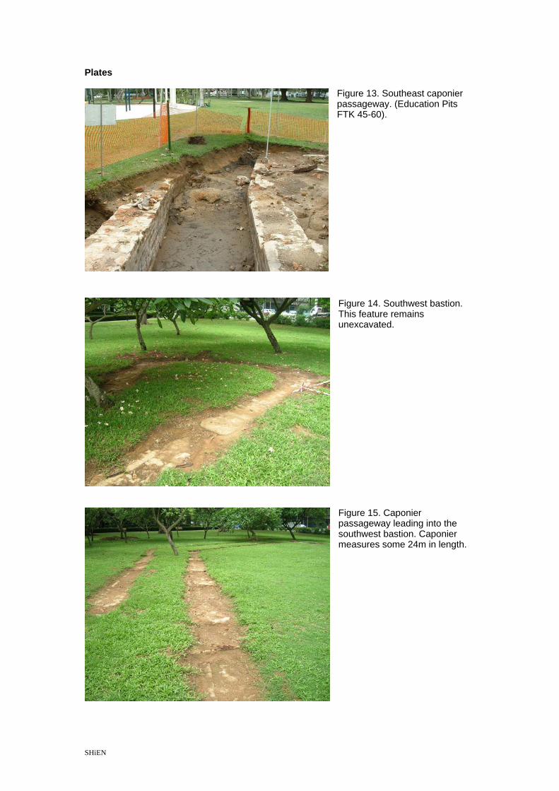
Figure 13. Southeast caponier passageway. (Education Pits FTK 45-60).
Figure 14. Southwest bastion. This feature remains unexcavated.
Figure 15. Caponier passageway leading into the southwest bastion. Caponier measures some 24m in length.
SHiEN 21

Plates
Figure 16. Rubble field at the end of the southwest caponier passageway (FTK 70-75).
Figures 17 and 18. 1930s Park footpath uncovered (FTK 63, 64, 69 and 78)..
Figure 19. Volunteers processing artifacts at Katong Community Center.
SHiEN 22

Plates
Figure 20. Student volunteers assist with the washing and sorting of artifacts.
Figure 21. Artifacts bagged and tagged into (L-R) Ceramics, Metal, Coral & Faunal, Glass categories, ready for analysis and cataloging.
Figure 22. Bottles and glass shards recovered from the site.
SHiEN 23

Plates
Figure 23. 1885 plan for the proposed revision to the existing battery (Historical background of Katong Fort, Historical Sites Unit, National Heritage Board Report 2002).
Figure 24. Sketch of Tanjong Katong battery c.1885 (courtesy of Alan Harfield).
SHiEN 24

Plates
Figure 25. 1965 RAF air photo depicting the East Coast prior to land reclamation. Katong Park can be seen on the top right (National Archives of Singapore).
Figure 26. Magnification of air photo. The swimming enclosure, rest shed (former Japanese machine testing bays), southeast bastion, perimeter of the moat escarp are visible.
SHiEN 25

Plates
Figure 27. 1906 Map showing the outlines of Fort Tanjong Katong (National Archives of Singapore).
Figure 28. 1932 Map showing Katong Park with bandstand, bathing enclosure and footpaths (National Archives of Singapore).
SHiEN 26

Plates
Figure 29. Line drawing of 7 inch Rifled muzzle loader (RML) of 7 tons (courtesy of David Moore).
Figure 30. Drawing of 7 inch RML on C pivot mount (courtesy of David Moore).
SHiEN 27

Plates
Figure 31. Rear – The Singapore 8 inch Breech Loading (BL) gun now on display at Royal Artillery Museum United Kingdom. It was removed to the UK in 1967/8 and originated either from Fort Tanjong Katong or Fort Serapong on Blakan Mati (David Moore). Plates
Figure 31. Plan of the New Defence Scheme for Singapore 1885. It shows Fort Tanjong Katong prior to the upgrade to 8 inch Breech Loading (BL) guns (in Kathiravelu’s unpublished thesis).
SHiEN 28

Plates
Figure 32. Singapore Proposed Defences 1886 cutting from Admiralty Chart No.2404 depicting new 8 inch BL guns in place at Tanjong Katong (National University of Singapore Library CO537/46).
SHiEN 29

Plates
Figure 33. Site plan showing excavation units with 1885 plan overlay on present park.
SHiEN 30