FORM Referral of a Proposal by the Proponent to the ...
36
1 EPA REFERRAL FORM PROPONENT Referral of a Proposal by the Proponent to the Environmental Protection Authority under Section 38(1) of the Environmental Protection Act 1986. PURPOSE OF THIS FORM Section 38(1) of the Environmental Protection Act 1986 (EP Act) provides that where a development proposal is likely to have a significant effect on the environment, a proponent may refer the proposal to the Environmental Protection Authority (EPA) for a decision on whether or not it requires assessment under the EP Act. This form sets out the information requirements for the referral of a proposal by a proponent. Proponents are encouraged to familiarise themselves with the EPA’s General Guide on Referral of Proposals [see Environmental Impact Assessment/Referral of Proposals and Schemes] before completing this form. A referral under section 38(1) of the EP Act by a proponent to the EPA must be made on this form. A request to the EPA for a declaration under section 39B (derived proposal) must be made on this form. This form will be treated as a referral provided all information required by Part A has been included and all information requested by Part B has been provided to the extent that it is pertinent to the proposal being referred. Referral documents are to be submitted in two formats – hard copy and electronic copy. The electronic copy of the referral will be provided for public comment for a period of 7 days, prior to the EPA making its decision on whether or not to assess the proposal. CHECKLIST Before you submit this form, please check that you have: Yes No Completed all the questions in Part A (essential). Completed all applicable questions in Part B. Included Attachment 1 – location maps. Included Attachment 2 – additional document(s) the proponent wishes to provide (if applicable). Included Attachment 3 – confidential information (if applicable). Enclosed an electronic copy of all referral information, including spatial data and contextual mapping but excluding confidential information.
Transcript of FORM Referral of a Proposal by the Proponent to the ...
1
EP
A R
EF
ER
RA
L
FO
RM
PR
OP
ON
EN
T
Referral of a Proposal by the Proponent to the Environmental Protection Authority under Section 38(1) of the Environmental Protection Act 1986.
PURPOSE OF THIS FORM Section 38(1) of the Environmental Protection Act 1986 (EP Act) provides that where a development proposal is likely to have a significant effect on the environment, a proponent may refer the proposal to the Environmental Protection Authority (EPA) for a decision on whether or not it requires assessment under the EP Act. This form sets out the information requirements for the referral of a proposal by a proponent. Proponents are encouraged to familiarise themselves with the EPA’s General Guide on Referral of Proposals [see Environmental Impact Assessment/Referral of Proposals and Schemes] before completing this form. A referral under section 38(1) of the EP Act by a proponent to the EPA must be made on this form. A request to the EPA for a declaration under section 39B (derived proposal) must be made on this form. This form will be treated as a referral provided all information required by Part A has been included and all information requested by Part B has been provided to the extent that it is pertinent to the proposal being referred. Referral documents are to be submitted in two formats – hard copy and electronic copy. The electronic copy of the referral will be provided for public comment for a period of 7 days, prior to the EPA making its decision on whether or not to assess the proposal. CHECKLIST Before you submit this form, please check that you have: Yes No Completed all the questions in Part A (essential).
Completed all applicable questions in Part B.
Included Attachment 1 – location maps.
Included Attachment 2 – additional document(s) the proponent wishes to provide (if applicable).
Included Attachment 3 – confidential information (if applicable).
Enclosed an electronic copy of all referral information, including spatial data and contextual mapping but excluding confidential information.


3
PART A - PROPONENT AND PROPOSAL INFORMATION (All fields of Part A must be completed for this document to be treated as a referral) 1 PROPONENT AND PROPOSAL INFORMATION 1.1 Proponent
Name Warrego Energy Pty Ltd
Joint Venture parties (if applicable) Not applicable
Australian Company Number (if applicable)
133046787
Postal Address
37-39 Hay St, Subiaco WA 6008
Key proponent contact for the proposal: name address phone email
Duncan MacNiven (Warrego Energy) 37-39 Hay St Subiaco WA 6008 T: +61 8 9467 7822 M: +44 (0) 7984 158 740 E: [email protected]
Consultant for the proposal (if applicable): name address phone email
Natassja Raymond (Coffey) Suite 2, 53 Burswood Rd, Burswood, WA, 6100 T: 9269 6200 E: [email protected]
1.2 Proposal
Title West Erregulla Seismic Survey Description Warrego Energy Pty Ltd (Warrego
Energy) plans to conduct a three-dimensional (3D) seismic survey (this project) within exploration permit EP 469, approximately 50 km southeast of Dongara and 300 km north of Perth (Figure 1).
Extent (area) of proposed ground disturbance.
Maximum disturbance footprint of 70 ha, within the 8,575 ha project area (Figure 2).
Timeframe in which the activity or development is proposed to occur (including start and finish dates where applicable).
The project is currently scheduled to be undertaken in a phased manner between July and November 2014. This timing is driven by obligations under the exploration permit and land use constraints, for example, agricultural activity. Implementation of the project, however, is subject to the availability of survey equipment and agricultural harvest timing.

4
Details of any staging of the proposal. As discussed above the work will be undertaken in a phased manner, with the ground disturbance work undertaken ahead of the 3D seismic survey (e.g. July/August) to reduce the risk of fire and other safety risks otherwise associated with potential contractor/machinery interactions. The total duration of the project including the line preparation phase and the seismic survey is approximately six weeks.
Is the proposal a strategic proposal?
No.
Is the proponent requesting a declaration that the proposal is a derived proposal? If so, provide the following information on the strategic assessment within which the referred proposal was identified:
title of the strategic assessment; and Ministerial Statement number.
No.
Please indicate whether, and in what way, the proposal is related to other proposals in the region.
Not applicable.
Does the proponent own the land on which the proposal is to be established? If not, what other arrangements have been established to access the land?
Warrego Energy is the sole holder of exploration permit EP 469, within which the project will occur. (Discussed further below.)
What is the current land use on the property, and the extent (area in hectares) of the property?
Land use within EP 469 includes Vacant Crown Land and Freehold land (Figure 3). The local indigenous group, the Amangu People, also have a Native Title claim (WC04/2) over EP 469. Land access/heritage protection agreements are in place will all affected parties.
1.3 Location Name of the Shire in which the proposal is located.
The project area is located within the Shires of Three Springs and Mingenew.
For urban areas: street address; lot number; suburb; and nearest road intersection.
Not applicable.
For remote localities: nearest town; and distance and direction from that town to the
proposal site.
The project is located onshore approximately 50 km southeast of Dongara and 300 km north of Perth, Western Australia (Figure 1)

5
Electronic copy of spatial data - GIS or CAD, geo-referenced and conforming to the following parameters:
GIS: polygons representing all activities and named;
CAD: simple closed polygons representing all activities and named;
datum: GDA94; projection: Geographic (latitude/longitude)
or Map Grid of Australia (MGA); format: Arcview shapefile, Arcinfo
coverages, Microstation or AutoCAD.
Enclosed? Yes / No Please see enclosed DVD at back of report.
1.4 Confidential Information
Does the proponent wish to request the EPA to allow any part of the referral information to be treated as confidential?
Yes / No
If yes, is confidential information attached as a separate document in hard copy?
Yes / No
1.5 Government Approvals
Is rezoning of any land required before the proposal can be implemented? If yes, please provide details.
Yes / No
Is approval required from any Commonwealth or State Government agency or Local Authority for any part of the proposal? If yes, please complete the table below.
Yes / No
Agency/Authority Approval required Application lodged Yes / No
Agency/Authority contact(s) for proposal
Department of the Environment
EPBC Act Approval –Granted (EPBC 2012/ 7054), provided as Attachment A.
Yes Victoria Press
Department of Mines and Petroleum
Native Vegetation Clearing Permit – Granted (5899/2), provided as Attachment B.
Yes Alicia Dudzinska
Department of Mines and Petroleum
Environment Plan – Approved (v8), provided as Attachment C.
Yes Stan Bowes / Laura McCarthy
Department of Parks and Wildlife
Permit to Take Threatened Flora – Granted (152-1314), provided as Attachment D.
Yes Anthea Jones / Janine Kuehs

6
PART B - ENVIRONMENTAL IMPACTS AND PROPOSED MANAGEMENT
2. ENVIRONMENTAL IMPACTS Describe the impacts of the proposal on the following elements of the environment, by answering the questions contained in Sections 2.1-2.11:
2.1 flora and vegetation;
2.2 fauna;
2.3 rivers, creeks, wetlands and estuaries;
2.4 significant areas and/ or land features;
2.5 coastal zone areas;
2.6 marine areas and biota;
2.7 water supply and drainage catchments;
2.8 pollution;
2.9 greenhouse gas emissions;
2.10 contamination; and
2.11 social surroundings.
These features should be shown on the site plan, where appropriate.
For all information, please indicate:
(a) the source of the information; and
(b) the currency of the information.
2.1 Flora and Vegetation
2.1.1 Do you propose to clear any native flora and vegetation as a part of this proposal?
Yes If yes, complete the rest of this section.
No If no, go to the next section
2.1.2 How much vegetation are you proposing to clear (in hectares)?
All project activities will be confined to the project area, which covers an area of approximately 8,575 ha (Figure 2). The project’s development footprint is estimated to be a maximum of 86.2 ha, representing about 1% of the project area. The conceptual disturbance footprint is depicted in Figure 2, identifying the nominal position of the seismic survey lines and associated infrastructure.
It is important to note that approximately 28 ha of the conceptual disturbance footprint occurs within already cleared land so only 58.5 ha of ground disturbance will be required. This area may increase slightly given Warrego’s commitment to avoid certain environmental values (e.g. length of a source line may increase slightly where it is diverted to avoid a known location of Threatened flora). To allow for this Warrego Energy commits to disturb no more than 70 ha within the project area (approximately 0.8% of the project area).

7
2.1.3 Have you submitted an application to clear native vegetation to the DEC (unless you are exempt from such a requirement)?
Yes No If yes, on what date and to which office was the application submitted of the DEC?
The application for a Native Vegetation Clearing Permit (NVCP) was submitted to the Department of Mines and Petroleum (DMP) on the 14 November 2013.
The NVCP (5899/2) was subsequently granted by the DMP on the 11 April 2014.
2.1.4 Are you aware of any recent flora surveys carried out over the area to be disturbed by this proposal?
Yes No If yes, please attach a copy of any related survey reports and provide the date and name of persons / companies involved in the survey(s).
A Level 2 flora and vegetation survey was conducted over the project area by Woodman Environmental Consulting (Woodman Environmental) in accordance with the EPA’s Guidance Statement No. 51 Terrestrial Flora and Vegetation Surveys for Environmental Impact Assessment in Western Australia (EPA, 2004a).
The survey included a desktop assessment, an initial reconnaissance visit (15 September 2011), a detailed survey over three visits in spring 2011 (26 to 30 September, 24 to 27 October and 20 to 26 November) and another two surveys in spring 2012 (10 to 13 September and 2 to 5 October).
The full report (Woodman Environmental, 2013) is provided as Attachment E, and also discusses other historical flora surveys that have been conducted within and nearby the project area.
2.1.5 Has a search of DEC records for known occurrences of rare or priority flora or threatened ecological communities been conducted for the site?
Yes No
DPAW’s database of Threatened Ecological Communities (TECs) and Priority Ecological Communities (PECs) was searched for records of TECs and PECs within a 20 km radius of a point between Tomkins Road and Sand Plain Creek (Woodman Environmental, 2013). This search area encompassed the project area as well as some of the surrounding region.
A search of the DOTE database for Matters of National Environmental Significance (MNES) within the survey area was also conducted (Woodman Environmental, 2013).
A total of 73 conservation significant flora species, including nine Threatened (Declared Rare Flora) species, occur or have the potential to occur in the project area, based on data compiled from historical studies in the area and records from DPAW databases (refer to Table 4 of Attachment E).
8
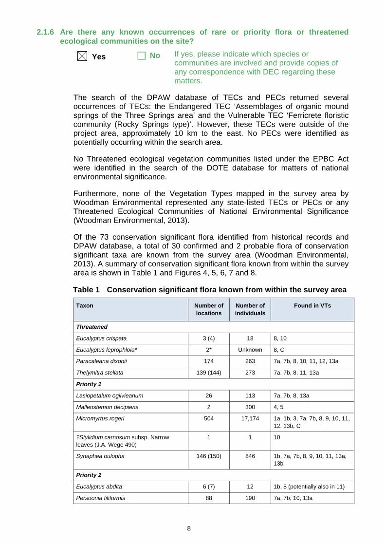
2.1.6 Are there any known occurrences of rare or priority flora or threatened ecological communities on the site?
Yes No If yes, please indicate which species or communities are involved and provide copies of any correspondence with DEC regarding these matters.
The search of the DPAW database of TECs and PECs returned several occurrences of TECs: the Endangered TEC ‘Assemblages of organic mound springs of the Three Springs area’ and the Vulnerable TEC ‘Ferricrete floristic community (Rocky Springs type)’. However, these TECs were outside of the project area, approximately 10 km to the east. No PECs were identified as potentially occurring within the search area.
No Threatened ecological vegetation communities listed under the EPBC Act were identified in the search of the DOTE database for matters of national environmental significance.
Furthermore, none of the Vegetation Types mapped in the survey area by Woodman Environmental represented any state-listed TECs or PECs or any Threatened Ecological Communities of National Environmental Significance (Woodman Environmental, 2013).
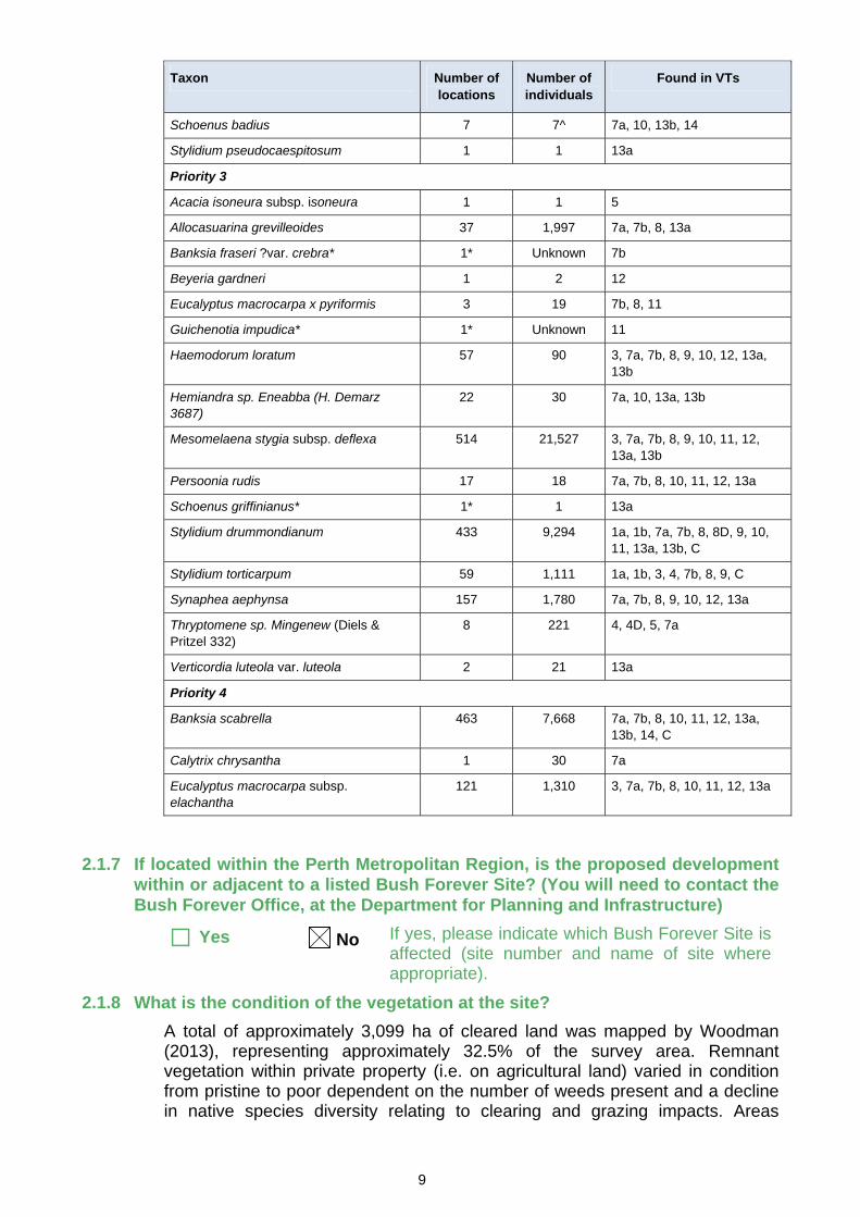
Of the 73 conservation significant flora identified from historical records and DPAW database, a total of 30 confirmed and 2 probable flora of conservation significant taxa are known from the survey area (Woodman Environmental, 2013). A summary of conservation significant flora known from within the survey area is shown in Table 1 and Figures 4, 5, 6, 7 and 8.
Table 1 Conservation significant flora known from within the survey area
Taxon Number of locations
Number of individuals
Found in VTs
Threatened
Eucalyptus crispata 3 (4) 18 8, 10
Eucalyptus leprophloia* 2* Unknown 8, C
Paracaleana dixonii 174 263 7a, 7b, 8, 10, 11, 12, 13a
Thelymitra stellata 139 (144) 273 7a, 7b, 8, 11, 13a
Priority 1
Lasiopetalum ogilvieanum 26 113 7a, 7b, 8, 13a
Malleostemon decipiens 2 300 4, 5
Micromyrtus rogeri 504 17,174 1a, 1b, 3, 7a, 7b, 8, 9, 10, 11, 12, 13b, C
?Stylidium carnosum subsp. Narrow leaves (J.A. Wege 490)
1 1 10
Synaphea oulopha 146 (150) 846 1b, 7a, 7b, 8, 9, 10, 11, 13a, 13b
Priority 2
Eucalyptus abdita 6 (7) 12 1b, 8 (potentially also in 11)
Persoonia filiformis 88 190 7a, 7b, 10, 13a
9
Taxon Number of locations
Number of individuals
Found in VTs
Schoenus badius 7 7^ 7a, 10, 13b, 14
Stylidium pseudocaespitosum 1 1 13a
Priority 3
Acacia isoneura subsp. isoneura 1 1 5
Allocasuarina grevilleoides 37 1,997 7a, 7b, 8, 13a
Banksia fraseri ?var. crebra* 1* Unknown 7b
Beyeria gardneri 1 2 12
Eucalyptus macrocarpa x pyriformis 3 19 7b, 8, 11
Guichenotia impudica* 1* Unknown 11
Haemodorum loratum 57 90 3, 7a, 7b, 8, 9, 10, 12, 13a, 13b
Hemiandra sp. Eneabba (H. Demarz 3687)
22 30 7a, 10, 13a, 13b
Mesomelaena stygia subsp. deflexa 514 21,527 3, 7a, 7b, 8, 9, 10, 11, 12, 13a, 13b
Persoonia rudis 17 18 7a, 7b, 8, 10, 11, 12, 13a
Schoenus griffinianus* 1* 1 13a
Stylidium drummondianum 433 9,294 1a, 1b, 7a, 7b, 8, 8D, 9, 10, 11, 13a, 13b, C
Stylidium torticarpum 59 1,111 1a, 1b, 3, 4, 7b, 8, 9, C
Synaphea aephynsa 157 1,780 7a, 7b, 8, 9, 10, 12, 13a
Thryptomene sp. Mingenew (Diels & Pritzel 332)
8 221 4, 4D, 5, 7a
Verticordia luteola var. luteola 2 21 13a
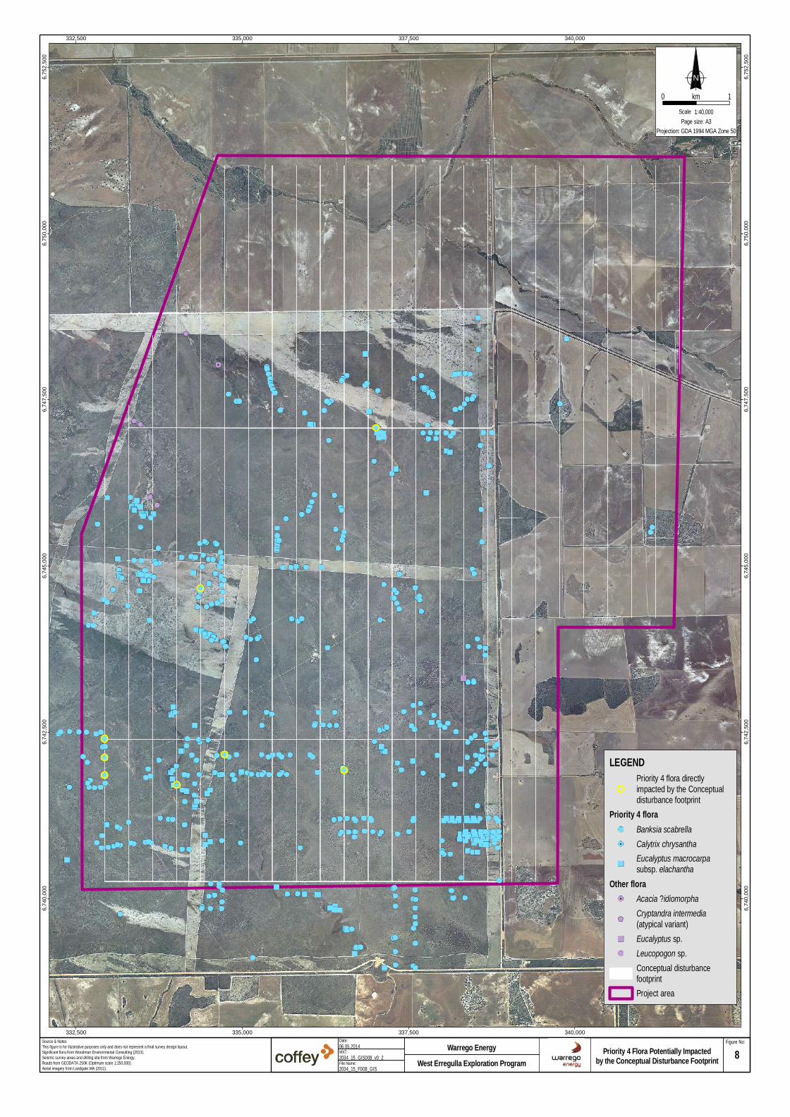
Priority 4
Banksia scabrella 463 7,668 7a, 7b, 8, 10, 11, 12, 13a, 13b, 14, C
Calytrix chrysantha 1 30 7a
Eucalyptus macrocarpa subsp. elachantha
121 1,310 3, 7a, 7b, 8, 10, 11, 12, 13a
2.1.7 If located within the Perth Metropolitan Region, is the proposed development within or adjacent to a listed Bush Forever Site? (You will need to contact the Bush Forever Office, at the Department for Planning and Infrastructure)
Yes No If yes, please indicate which Bush Forever Site is affected (site number and name of site where appropriate).
2.1.8 What is the condition of the vegetation at the site?
A total of approximately 3,099 ha of cleared land was mapped by Woodman (2013), representing approximately 32.5% of the survey area. Remnant vegetation within private property (i.e. on agricultural land) varied in condition from pristine to poor dependent on the number of weeds present and a decline in native species diversity relating to clearing and grazing impacts. Areas

10
ranked good to poor were generally associated with Sand Plain Creek where these pressures were greatest (Woodman, 2013).
The majority of native vegetation located within Vacant Crown Land was considered to be in ‘pristine’ condition with no obvious signs of disturbance (Woodman, 2013). However, several of the surveyed quadrats contained introduced species and were often associated with areas containing Eucalyptus accedens (Wandoo) (Woodman, 2013). Vegetation condition mapping over the project area is provided in the Level 2 flora and vegetation report, provided as Attachment E.
Woodman (2013) recorded a total of 22 introduced flora within the survey area. None of these weeds are listed as Weeds of National Significance, although one species, Echium plantagineum (Patersons Curse), is a Declared pest under the Biosecurity and Agricultural Management Act 2007; however, it is not declared in the shires within which the project area occurs. For a full list and description of each of the weed species, refer to the Level 2 flora and vegetation report, provided as Attachment E.
Glevan Consulting (2012) was commissioned by Woodman to conduct an assessment for the presence of Phytophthora Dieback in the project area (report provided as Attachment F). No areas of remnant vegetation within the Vacant Crown Land were observed to be currently impacted or infected by, nor considered to be altered by the previous introduction of, Phytophthora Dieback. This area should be considered as being protectable from the Phytophthora Dieback disease. Areas of remnant vegetation within agricultural land were not examined, as they were unmappable (i.e. sufficiently disturbed that dieback occurrence mapping was not possible at time of inspection).
2.2 Fauna
2.2.1 Do you expect that any fauna or fauna habitat will be impacted by the proposal?
Yes
If yes, complete the rest of this section.
No If no, go to the next section.
2.2.2 Describe the nature and extent of the expected impact.
Potential impacts of the Project on terrestrial vertebrate fauna present within the project area include; loss or degradation of fauna habitat; fauna injuries and mortalities from interactions with project vehicles, machinery and infrastructure; increased predation by introduced fauna; altered fauna behaviour associated with noise, vibration and light emissions and increased risk of fire (Coffey, 2013).
As discussed previously, Warrego Energy has committed to clearing no more than 70 ha within the project area (approximately 0.8% of the project area). Warrego Energy has also committed to avoid clearing all large trees, open Eucalyptus forest habitat and planted Eucalypt habitat.
Based on the current conceptual disturbance footprint (Figure 9) the project will impact less than 64 ha of habitat within the project area as detailed in Table 2.
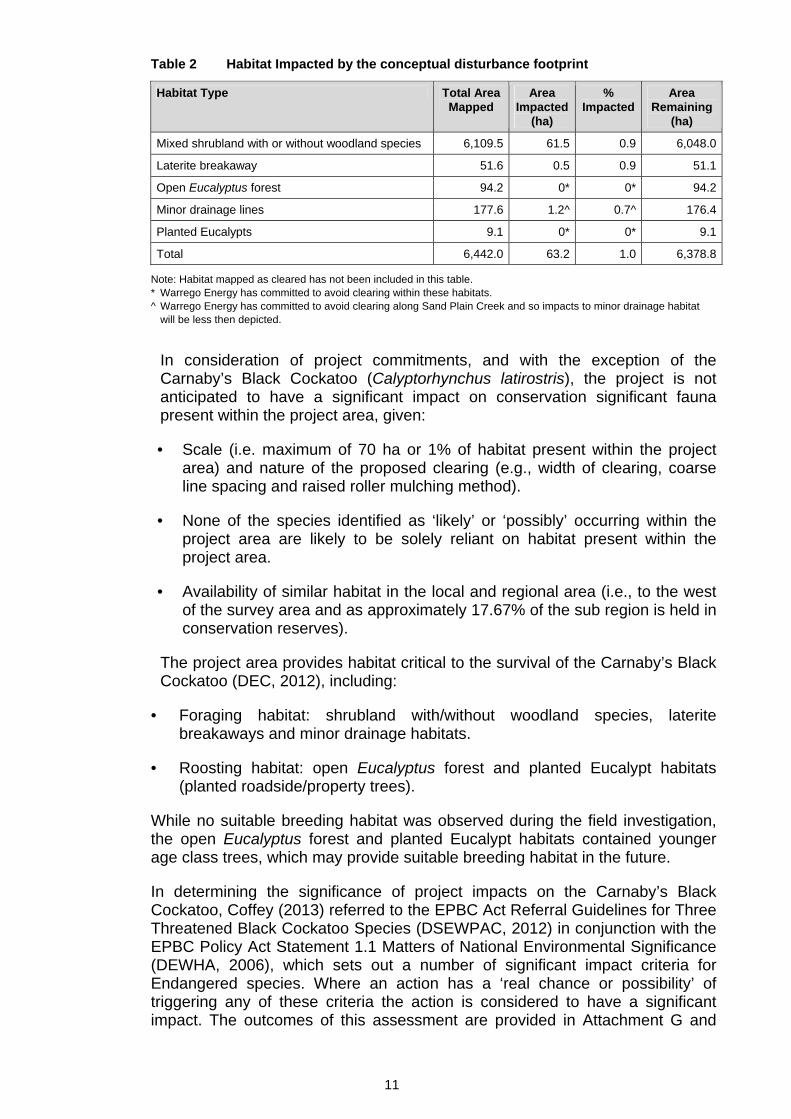
11
Table 2 Habitat Impacted by the conceptual disturbance footprint
Habitat Type Total Area Mapped
Area Impacted
(ha)
% Impacted
Area Remaining
(ha)
Mixed shrubland with or without woodland species 6,109.5 61.5 0.9 6,048.0
Laterite breakaway 51.6 0.5 0.9 51.1
Open Eucalyptus forest 94.2 0* 0* 94.2
Minor drainage lines 177.6 1.2^ 0.7^ 176.4
Planted Eucalypts 9.1 0* 0* 9.1
Total 6,442.0 63.2 1.0 6,378.8
Note: Habitat mapped as cleared has not been included in this table. * Warrego Energy has committed to avoid clearing within these habitats. ^ Warrego Energy has committed to avoid clearing along Sand Plain Creek and so impacts to minor drainage habitat
will be less then depicted.
In consideration of project commitments, and with the exception of the Carnaby’s Black Cockatoo (Calyptorhynchus latirostris), the project is not anticipated to have a significant impact on conservation significant fauna present within the project area, given:
• Scale (i.e. maximum of 70 ha or 1% of habitat present within the project area) and nature of the proposed clearing (e.g., width of clearing, coarse line spacing and raised roller mulching method).
• None of the species identified as ‘likely’ or ‘possibly’ occurring within the project area are likely to be solely reliant on habitat present within the project area.
• Availability of similar habitat in the local and regional area (i.e., to the west of the survey area and as approximately 17.67% of the sub region is held in conservation reserves).
The project area provides habitat critical to the survival of the Carnaby’s Black Cockatoo (DEC, 2012), including:
• Foraging habitat: shrubland with/without woodland species, laterite breakaways and minor drainage habitats.
• Roosting habitat: open Eucalyptus forest and planted Eucalypt habitats (planted roadside/property trees).
While no suitable breeding habitat was observed during the field investigation, the open Eucalyptus forest and planted Eucalypt habitats contained younger age class trees, which may provide suitable breeding habitat in the future.
In determining the significance of project impacts on the Carnaby’s Black Cockatoo, Coffey (2013) referred to the EPBC Act Referral Guidelines for Three Threatened Black Cockatoo Species (DSEWPAC, 2012) in conjunction with the EPBC Policy Act Statement 1.1 Matters of National Environmental Significance (DEWHA, 2006), which sets out a number of significant impact criteria for Endangered species. Where an action has a ‘real chance or possibility’ of triggering any of these criteria the action is considered to have a significant impact. The outcomes of this assessment are provided in Attachment G and

12
have been reconsidered in light of the current development footprint and Warrego Energy’s management and mitigation commitments in Section 4.3 of Attachment H.
Coffey determined that the project only has a ‘real chance or possibility’ of triggering one of the nine criteria, specifically ‘adversely affecting habitat critical to the survival of the species’, given that some clearing of foraging habitat is unavoidable.
The impact of clearing on this species is believed to be of limited significance, given the following:
Scale (i.e. maximum of 70 ha, 1% of foraging habitat present within the survey area) and nature of the proposed clearing (e.g., width of clearing, coarse grid spacing and raised roller mulching method). Of particular importance is the method of clearing, raised roller mulching preserves rootstock and retains seedstock, which will increase the success of natural rehabilitation and revegetation on completion of the project.
Short-term nature of the impact. The project will be completed over approximately six weeks between July and December, and disturbed areas will be closed and allowed to regenerate naturally.
Commitment to utilise existing areas of disturbance as much as practicable and to retain/avoid clearing all large trees (e.g. Banksia spp.), open Eucalyptus forest habitat and planted Eucalypt habitat (roosting and potential breeding habitat).
The implementation of an approved rehabilitation plan developed in line with industry standards and in consultation with the Department of Mines and Petroleum (DMP) and the Department of Parks and Wildlife (DPAW).
Availability of similar foraging and roosting habitat in the local and regional area (i.e., directly to the west of the survey area and as over 21% of remnant vegetation in vegetation associations Tathra-379 and Tathra-49 which encompass the project area are held in conservation reserves.
2.2.3 Are you aware of any recent fauna surveys carried out over the area to be disturbed by this proposal?
Yes No If yes, please attach a copy of any related survey reports and provide the date and name of persons / companies involved in the survey(s).
If no, please do not arrange to have any biological surveys conducted prior to consulting with the DEC.
Coffey Environments Australia (Coffey) undertook a Level 1 fauna assessment in accordance with the Guidance for the Assessment of Environmental Factors No. 56 (EPA, 2004b) Terrestrial Fauna Surveys for Environmental Impact Assessment (EPA, 2002) and Technical Guide – Terrestrial Vertebrate Fauna Surveys for Environmental Impact Assessment (EPA and DEC, 2010). Coffey also undertook a Black Cockatoo habitat assessment in accordance with the EPBC Act Referral Guidelines for Three Threatened Black Cockatoo Species (DSEWPaC, 2012). The full report (Coffey, 2013) detailing the outcomes of the Level 1 fauna assessment is provided as Attachment G.

13
2.2.4 Has a search of DEC records for known occurrences of Specially Protected (threatened) fauna been conducted for the site?
Yes No
Coffey’s (2013) Level 1 fauna assessment included a search and review of the:
• DEC NatureMap online database.
• DEC Threatened and Priority Species database.
• Commonwealth Government database of fauna of national environmental significance (EPBC Protected Matters Search Tool).
2.2.5 Are there any known occurrences of Specially Protected (threatened) fauna on the site?
Yes No If yes, please indicate which species or communities are involved and provide copies of any correspondence with DEC regarding these matters.
A total of 302 vertebrate fauna species, 20 of which are conservation significant, have previously been recorded within the region and so have the potential to occur within the survey area (Coffey, 2013). Coffey undertook an assessment to determine the likelihood of these species occurring within the survey area based on the availability of suitable habitat, known distribution of each species and currency of species records (Coffey, 2013). None of the conservation significant fauna species listed in Table 5 were recorded during the Level 1 fauna survey. Of the 20 species of conservation significance, seven were considered ‘likely’ to occur and another six were considered as ‘possibly’ occurring within the survey area, as detailed in Table 3.
Table 3 Conservation significant fauna potentially occurring within the project area
Common Name WC Act/DEC Status1
EPBC Act Status1
Potential to Exist Within Survey Area2
Carnaby's Black Cockatoo (Calyptorhynchus latirostris) Schedule 1 Endangered Likely
Peregrine Falcon (Falco peregrinus) Schedule 4 — Likely
Australian Bustard (Ardeotis australis) Priority 4 — Likely
Rufous Fieldwren (Calamanthus campestris subsp. Montanellis)
Priority 4 — Likely
White-browed Babbler (Pomatostomus superciliosus subsp. ashbyi)
Priority 4 — Possible
Rainbow Bee-eater (Merops ornatus) Schedule 3 Migratory Likely
Fork-tailed Swift (Apus pacificus) Schedule 3 Migratory Possible
Great Egret (Ardea alba) Schedule 3 Migratory Possible
Cattle Egret (Ardea ibis) Schedule 3 Migratory Possible
Western Brush Wallaby (Macropus irma) Priority 4 — Possible

14
Common Name WC Act/DEC Status1
EPBC Act Status1
Potential to Exist Within Survey Area2
Gilled Slender-Bluetongue (Cyclodomorphus branchialis) Schedule 1 — Likely
Woma (Aspidites ramsayi) Schedule 4, Priority 1
— Possible
Western Carpet Python (Morelia spilota imbricata) Schedule 4, Priority 4
— Likely
1. Definitions for WC Act/DEC Status and EPBC Act categories are provided in Attachment G. 2. Likelihood of Occurrence: Likely – Suitable habitat present, species recently recorded in the region;
Possible – Suitable habitat present, limited species records in the region; Unlikely – Absence of suitable habitat, known distribution outside the survey area.
2.3 Rivers, Creeks, Wetlands and Estuaries
2.3.1 Will the development occur within 200 metres of a river, creek, wetland or estuary?
Yes
If yes, complete the rest of this section.
No If no, go to the next section.
The project area is generally devoid of any significant permanent surface water features (RPS, 2011).
The most significant drainage system in the project area is Sand Plain Creek, which passes through agricultural land in the north of the project area (Figure 2).
2.3.2 Will the development result in the clearing of vegetation within the 200 metre zone?
Yes No If yes, please describe the extent of the expected impact.
As illustrated in Figure 2 the seismic survey will operate across an area of Sand Plain Creek on Freehold land, which falls within the project area.
Woodman (2013) ranked remnant vegetation surrounding Sand Plain Creek as ‘Very Good’ to ‘Good’, due to the decline of native species diversity associated with clearing, impacts from grazing stock and increased weed loading. The larger river systems outside the project area are known to flow intermittently, flowing predominantly in winter and with some semi permanent pools persisting through summer (RPS, 2011). The same ephemeral nature is likely to be the case for Sand Plain Creek although given its minor nature it is less likely that standing water persists through summer.
Warrego Energy has committed to avoid clearing within 20 m Sand Plain Creek and utilising existing crossings to minimise disturbance.
Warrego Energy has also committed to preparing and implementing a dieback and weed management plan.
Any activities undertaken around Sand Plain Creek will also be undertaken in accordance with the relevant land access agreements.

15
2.3.3 Will the development result in the filling or excavation of a river, creek, wetland or estuary?
Yes No If yes, please describe the extent of the expected impact.
2.3.4 Will the development result in the impoundment of a river, creek, wetland or estuary?
Yes No If yes, please describe the extent of the expected impact.
2.3.5 Will the development result in draining to a river, creek, wetland or estuary?
Yes No If yes, please describe the extent of the expected impact.
2.3.6 Are you aware if the proposal will impact on a river, creek, wetland or estuary (or its buffer) within one of the following categories? (please tick)
Conservation Category Wetland Yes No Unsure
Environmental Protection (South West Agricultural Zone Wetlands) Policy 1998 Yes No Unsure
Perth’s Bush Forever site Yes No Unsure
Environmental Protection (Swan & Canning Rivers) Policy 1998 Yes No Unsure
The management area as defined in s4(1) of the Swan River Trust Act 1988 Yes No Unsure
Which is subject to an international agreement, because of the importance of the wetland for waterbirds and waterbird habitats (e.g. Ramsar, JAMBA, CAMBA)
Yes No Unsure
2.4 Significant Areas and/ or Land Features
2.4.1 Is the proposed development located within or adjacent to an existing or proposed National Park or Nature Reserve?
Yes No If yes, please provide details.
The closest conservation areas to the project area are (see Figure 1):
• Wilson Nature Reserve, located approximately 15 km to the southeast.
• Yardanogo Nature Reserve, located approximately 15 km to the west.
• Beekeepers Nature Reserve located approximately 40 km to the southwest.

16
The project area does not provide a direct ecological linkage or buffer to any of the above-mentioned conservation areas and so it is unlikely that the project will impact any of these conservation areas.
2.4.2 Are you aware of any Environmentally Sensitive Areas (as declared by the Minister under section 51B of the EP Act) that will be impacted by the proposed development?
Yes No If yes, please provide details.
There are two Environmentally Sensitive Areas (ESAs), one within and one in close proximity to the project area (Figure 1). ESA ID 6046, which is located within the project area, is believed to represent an erroneous record of the Threatened flora Eucalyptus leprophloia (Woodman, 2013). Nevertheless, Warrego Energy has committed to avoiding this ESA.
The project has also committed to avoid all known locations of Threatened flora (as documented in the conditions of the project’s existing approvals).
2.4.3 Are you aware of any significant natural land features (e.g. caves, ranges etc) that will be impacted by the proposed development?
Yes No If yes, please provide details.
2.5 Coastal Zone Areas (Coastal Dunes and Beaches)
2.5.1 Will the development occur within 300metres of a coastal area?
Yes If yes, complete the rest of this section.
No If no, go to the next section.
2.5.2 What is the expected setback of the development from the high tide level and from the primary dune?
Not applicable
2.5.3 Will the development impact on coastal areas with significant landforms including beach ridge plain, cuspate headland, coastal dunes or karst?
Yes No If yes, please describe the extent of the expected impact.
2.5.4 Is the development likely to impact on mangroves?
Yes No If yes, please describe the extent of the expected impact.
2.6 Marine Areas and Biota
2.6.1 Is the development likely to impact on an area of sensitive benthic communities, such as seagrasses, coral reefs or mangroves?
Yes No If yes, please describe the extent of the expected impact.
2.6.2 Is the development likely to impact on marine conservation reserves or areas recommended for reservation (as described in A Representative Marine Reserve System for Western Australia, CALM, 1994)?

17
Yes No If yes, please describe the extent of the expected impact.
2.6.3 Is the development likely to impact on marine areas used extensively for recreation or for commercial fishing activities?
Yes No If yes, please describe the extent of the expected impact, and provide any written advice from relevant agencies (e.g. Fisheries WA).
2.7 Water Supply and Drainage Catchments
2.7.1 Are you in a proclaimed or proposed groundwater or surface water protection area?
(You may need to contact the Department of Water (DoW) for more information on the requirements for your location, including the requirement for licences for water abstraction. Also, refer to the DoW website)
Yes No If yes, please describe what category of area.
2.7.2 Are you in an existing or proposed Underground Water Supply and Pollution Control area?
(You may need to contact the DoW for more information on the requirements for your location, including the requirement for licences for water abstraction. Also, refer to the DoW website)
Yes No If yes, please describe what category of area.
2.7.3 Are you in a Public Drinking Water Supply Area (PDWSA)?
(You may need to contact the DoW for more information or refer to the DoW website. A proposal to clear vegetation within a PDWSA requires approval from DoW.)
Yes No If yes, please describe what category of area.
2.7.4 Is there sufficient water available for the proposal?
(Please consult with the DoW as to whether approvals are required to source water as you propose. Where necessary, please provide a letter of intent from the DoW)
Yes No
Warrego Energy will not need to apply for any water licences, as onsite water requirements will be supplied in agreement with landowners and in accordance with landowners’ existing licences.
2.7.5 Will the proposal require drainage of the land?
Yes No If yes, how is the site to be drained and will the drainage be connected to an existing Local Authority or Water Corporation drainage system? Please provide details.
2.7.6 Is there a water requirement for the construction and/ or operation of this proposal?

18
Yes If yes, complete the rest of this section.
No If no, go to the next section.
2.7.7 What is the water requirement for the construction and operation of this proposal, in kilolitres per year?
Non-potable water may be required for the hygiene station, although the preference is for a dry facility. Non-potable water will also be required for fire response resources and may also be needed, on an as-required basis, for dust suppression. The total requirement of water for these purposes is estimated at a nominal 1 kL/day.
As the project is anticipated to operate for a maximum period of six weeks the project’s total water requirement will be 42 kL.
2.7.8 What is the proposed source of water for the proposal? (e.g. dam, bore,
surface water etc.)
Water will be sourced from an existing groundwater bore on freehold land within the project area by arrangement with the landholder. Water will be abstracted under the landholder’s existing water licence.
2.8 Pollution
2.8.1 Is there likely to be any discharge of pollutants from this development, such as noise, vibration, gaseous emissions, dust, liquid effluent, solid waste or other pollutants?
Yes If yes, complete the rest of this section.
No If no, go to the next section.
2.8.2 Is the proposal a prescribed premise, under the Environmental Protection Regulations 1987?
Yes No If yes, please describe what category of
prescribed premise.
2.8.3 Will the proposal result in gaseous emissions to air?
Yes No If yes, please briefly describe.
The project involves the use of machinery and vehicles to undertake line preparation (i.e. clearing) and the 3D Seismic Survey (i.e. vibroesis trucks and light vehicles) and will produce some greenhouse gas emissions.
2.8.4 Have you done any modelling or analysis to demonstrate that air quality standards will be met, including consideration of cumulative impacts from other emission sources?

19
Yes No If yes, please briefly describe.
2.8.5 Will the proposal result in liquid effluent discharge?
Yes No If yes, please briefly describe the nature, concentrations and receiving environment.
Liquid waste generated by the project is expected to be minimal and includes sewage and grey water from portable toilets and wastewater from wet hygiene stations.
Portable ablutions will be provided within the project area (e.g. trailer mounted facilities). Sewage and grey water will be collected and disposed of at a licensed facility by a licenced waste contractor. A dump point for small volumes of septic waste is also available in Mingenew if required.
Waste from the site office (including sewage and greywater), an existing facility on Freehold land, will be disposed of via the existing septic tank system at the premises.
Any wastewater from a wet hygiene station will be treated as infected/ contaminated and as such will not be allowed to escape the hygiene station area. The measures to achieve this will be documented in the dieback and weed management plan and may include dosing washdown water with swimming pool chlorine or by retaining wastewater in a sump and removing soil once the sump has dried out through natural seepage and evaporation.
2.8.6 If there is likely to be discharges to a watercourse or marine environment, has any analysis been done to demonstrate that the State Water Quality Management Strategy or other appropriate standards will be able to be met?
Yes No If yes, please describe.
2.8.7 Will the proposal produce or result in solid wastes?
Yes No If yes, please briefly describe the nature, concentrations and disposal location/ method.
Waste generated by the project is expected to be minimal. Wastes may be generated during:
• Meal breaks (e.g., food scraps, aluminium cans, plastic bottles, plastic wrapping, paper wrapping).
• Operation of the site office.
All solid wastes generated during the project will be stored in rubbish bags within project vehicles and returned to the (offsite) accommodation facilities each night for disposal. If the accommodation camp is located at existing facilities, waste will be disposed of by arrangement with the local shire or otherwise by using a licenced waste contractor. Recyclable waste will be recycled where recycling collection is available.

20
2.8.8 Will the proposal result in significant off-site noise emissions?
Yes No If yes, please briefly describe.
2.8.9 Will the development be subject to the Environmental Protection (Noise) Regulations 1997?
Yes No If yes, has any analysis been carried out to demonstrate that the proposal will comply with the Regulations? Please attach the analysis.
2.8.10 Does the proposal have the potential to generate off-site, air quality impacts, dust, odour or another pollutant that may affect the amenity of residents and other “sensitive premises” such as schools and hospitals (proposals in this category may include intensive agriculture, aquaculture, marinas, mines and quarries etc.)?
Yes No If yes, please describe and provide the distance to residences and other “sensitive premises”.
2.8.11 If the proposal has a residential component or involves “sensitive premises”, is it located near a land use that may discharge a pollutant?
Yes No Not Applicable
If yes, please describe and provide the distance to the potential pollution source
2.9 Greenhouse Gas Emissions
2.9.1 Is this proposal likely to result in substantial greenhouse gas emissions (greater than 100 000 tonnes per annum of carbon dioxide equivalent emissions)?
Yes No If yes, please provide an estimate of the annual gross emissions in absolute and in carbon dioxide equivalent figures.
2.9.2 Further, if yes, please describe proposed measures to minimise emissions, and any sink enhancement actions proposed to offset emissions.
2.10 Contamination
2.10.1 Has the property on which the proposal is to be located been used in the past for activities which may have caused soil or groundwater contamination?
Yes No Unsure If yes, please describe.
The area of Freehold land within the project area is used for agricultural purposes. A well was drilled in the Vacant Crown Land (West Erregulla-1 Well) by Barrack Energy Limited in 1990, following discovery of the West Erregulla Field.

21
2.10.2 Has any assessment been done for soil or groundwater contamination on the site?
Yes No If yes, please describe.
2.10.3 Has the site been registered as a contaminated site under the Contaminated Sites Act 2003? (on finalisation of the CS Regulations and proclamation of the CS Act)
Yes No If yes, please describe.
A search of the Department of Environment and Regulation’s Contaminated Sites Database has not identified any confirmed sites of contamination within the project area (DER, 2013).
2.11 Social Surroundings
2.11.1 Is the proposal on a property which contains or is near a site of Aboriginal ethnographic or archaeological significance that may be disturbed?
Yes No Unsure If yes, please describe.
A search of the Department of Aboriginal Affairs register identified that no registered Aboriginal sites occur within the project area (Terra Rossa, 2014).
An archaeological heritage field assessment conducted by Terra Rossa (2014) and members of the Amangu Traditional Owners did however identify two heritage restriction zones along Sand Plain Creek. The project has committed to avoiding these areas and utilising existing crossings only.
Warrego Energy is also committed to having representatives of the Amangu People as monitors during line preparation (clearing) to ensure any unidentified cultural material is managed appropriately.
2.11.2 Is the proposal on a property, which contains or is near a site of high public interest (e.g. a major recreation area or natural scenic feature)?
Yes No If yes, please describe.
2.11.3 Will the proposal result in or require substantial transport of goods, which may affect the amenity of the local area?
Yes No If yes, please describe.
3. PROPOSED MANAGEMENT
3.1 Principles of Environmental Protection
3.1.1 Have you considered how your project gives attention to the following
Principles, as set out in section 4A of the EP Act? (For information on the Principles of Environmental Protection, please see EPA Position Statement No. 7, available on the EPA website)
22
1. The precautionary principle. Yes No
2. The principle of intergenerational equity. Yes No
3. The principle of the conservation of biological diversity and ecological integrity.
Yes No
4. Principles relating to improved valuation, pricing and incentive mechanisms.
Yes No
5. The principle of waste minimisation. Yes No
3.1.2 Is the proposal consistent with the EPA’s Environmental Protection
Bulletins/Position Statements and Environmental Assessment Guidelines/Guidance Statements (available on the EPA website)?
Yes No
3.2 Consultation
3.2.1 Has public consultation taken place (such as with other government agencies, community groups or neighbours), or is it intended that consultation shall take place?
Yes No If yes, please list those consulted and attach comments or summarise response on a separate sheet.
Warrego Energy initiated a stakeholder consultation program in 2008 when it acquired exploration rights in EP 469. Since then, Warrego Energy has consulted with landholders, traditional owners, local government, state and federal government agencies and other stakeholders with regards to its broader West Erregulla Exploration Program, which includes a potential appraisal well in addition to this project (i.e. 3D seismic survey). Where the seismic survey is successful, Warrego Energy will seek future approval to drill an appraisal well as required by the petroleum exploration permit conditions.
The aim of the stakeholder consultation program was and is to inform stakeholders of Warrego Energy’s proposed activities and to identify any conflicts, concerns, management strategies and positive benefits.
Warrego Energy is committed to continuing the stakeholder consultation program while it has a presence in the region.
Consultation has involved the following parties:
• Department of Mines and Petroleum – Native Vegetation Branch and Petroleum Branch.
• Department of Parks and Wildlife (formerly the Department of Environment and Conservation) – Species and Communities Branch and Environmental Management Branch.
• Office of the Environmental Protection Authority.
• Commonwealth Department of the Environment (formerly the Department of Sustainability, Environment, Water, Population and Communities).
• Office of the Appeals Convenor.

23
• Department of Water.
• Department of Lands.
• Amangu people.
• Yamatji Marlpa Aboriginal Corporation.
• Shire of Mingenew.
• Shire of Three Springs.
• Origin Energy.
• AWE Limited.
• Norwest Energy NL
• UIL Energy.
• Empire Oil and Gas NL.
• Tronox Limited.
• Pipeline operators DBP Transmission and APA Group.
• Landholders.
Warrego Energy engaged consultants KD.1 Pty Ltd (KD.1) to manage its landholder consultation program. Warrego Energy has been consulting with landowners and land managers whose land may be traversed by the project, to make land access arrangements and to identify other relevant issues. Land access agreements to ensure access on acceptable terms with regards to access, timing, land husbandry, operational considerations, compensation and rehabilitation have been finalised with all four landholders in the project area. Warrego Energy will continue to develop land access arrangements with each of the landowners and managers and will honour the conditions of these agreements.
A summary of consultation with other key regulators is also provided below.
Warrego Energy met with the DMP Petroleum Branch (representatives: Laura McCarthy and Stan Bowes) in February 2012 to discuss the project. Consultation with the DMP Petroleum Branch has indicated that the Project environmental approvals required are an EP and NVCP, along with referral to the now DOTE, and that the Project is unlikely to trigger referral to the EPA under the memorandum of understanding (MOU).
Warrego Energy met with the DMP Native Vegetation Branch (representatives: Adam Buck and Matt Boardman) in June 2012 to discuss the Project. Consultation with the DMP Native Vegetation Branch identified the following:
• The NVCP Application should include the following:
– Management of significant fauna habitat (e.g. Black Cockatoos).
– Appropriate biosecurity measures to mitigate against dieback and the spread of weeds.
– Proposed rehabilitation measures (helpful but not essential), largely assessed through the EP process.
– Commitments that will assure the DMP that impacts to Threatened (Declared Rare) flora, priority flora and significant fauna habitat will be kept to ALARP or avoided altogether.

24
• If impacts to DRF are unavoidable, Warrego Energy will be required to obtain a Permit to Take from the DPAW.
Warrego Energy met with the DMP, Petroleum Branch (representatives: Laura McCarthy and Stan Bowes) and Native Vegetation Branch (representative: Alicia Dudzinska) again on 31 October 2013. Both branches of the DMP were happy to see that Warrego Energy had taken measures to avoid, mitigate and manage project impacts since the last meeting. They confirmed the assessment process and recommended prompt submission of the NVCP Application and EP to facilitate meeting the project schedule.
Warrego Energy met with the OEPA (representatives: Peter Tapsell, Maree Heath and Annaleigh Gunston) in November 2012 to discuss the Project. Consultation with the OEPA confirmed that the OEPA believes the project can be adequately assessed by the DMP and would only require the OEPA’s involvement in the event that the DMP and/or the DER were concerned that the proposed management of flora impacts was not satisfactory and decided to refer the project. The OEPA recommended that management approaches be developed in consultation with the DMP and DER.
Warrego Energy had initial discussions with the Department of Environment and Conservation (representatives: Kelly Griffiths and Ken Atkins) (now the DER and the DPAW) regarding the potential impacts to Threatened Flora and the Requirement to obtain a ‘Permit to Take’.
Warrego Energy also met with the DPAW Environmental Management Branch (representatives: Murray Baker and Grant Lamb) on 29 October 2013. The DPAW Environmental Management Branch recommended that a ‘Permit to Take’ would be required and an application should be submitted promptly to the Species and Communities Branch to allow parallel assessment with the NVCP application. The DPAW Environmental Management Branch also encouraged:
• The avoidance of Threatened, Priority 1 and Priority 2 flora.
• Implementation of a weed and dieback management plan.
• Development of a communication procedure with the Moora district office.
• Fire management.
• Avoidance of habitat trees.
• The design of access tracks to avoid third party access (i.e. doglegging).
• Rehabilitation monitoring.
Warrego Energy met with the DPAW Species and Communities Branch (representative: Dr Ken Atkins and Anthea Jones, along with Grant Lamb from the Environmental Management Branch for consistency) on 6 November 2013 to discuss potential impacts to Threatened flora and confirm the requirements of a ‘Permit to Take’ application. The DPAW Species and Communities Branch was pleased with the avoidance, mitigation and management measures in place and believed they generally represented best practice. It was recommended that rubber tyres be used and vehicle movements minimised to maximise the success of natural revegetation of disturbed areas. The preferred mechanism for dieback and weed control given project activities were to have been undertaken in March, was stated to be air blowing and brushing, with a particular focus on belly plates, rail guards and steps.

25
Warrego Energy met with the Commonwealth Department of the Environment on 29 October 2013 (representatives: Victoria Press and Erin Pears) to discuss the project. The DOTE were happy to see that Warrego Energy has taken measures to avoid, mitigate and manage impacts to matters of national environmental significance and that offset options were already being investigated should they be required. The DOTE also confirmed the various assessment processes and recommended a rigorous discussion of project impacts so, should it be determined that the project is a controlled action, the project may be assessed under an Assessment on Referral Information (ARI) level of assessment. The project was referred to the DOTE for assessment under the EPBC Act on 14 November 2013 (reference 2013/7054) and a decision was since made (10 December 2013) that the project is a controlled action and required assessment and approval under the EPBC Act, by ARI.
Discussions with both the DOTE and DMP have also taken place with regards to offsets, particularly in January 2014.
Warrego Energy has also been consulting with the local indigenous group, the Amangu People, who have a Native Title claim (WC04/2) over EP 469, and their representatives the Yamatji Marlpa Aboriginal Corporation since 2008 during the acquisition of this permit. Warrego Energy has a Heritage Protection Agreement with the Amangu People for the undertaking of low impact and ground disturbing petroleum operations on the land within EP 469 (previously referred to as EP 25/07-8) and will continue to honour the conditions of this agreement.
4. REFERENCES
Coffey Environments. 2013. Level 1 Vertebrate Fauna Survey – West Erregulla Exploration Program. Report prepared for Warrego Energy Ltd by Coffey Environments, Burswood, Western Australia.
DER. 2013. Contaminated Sites Database. A WWW publication accessed on 14 April 2012 at https://secure.dec.wa.gov.au/idelve/css/m. Department of Environment and Regulation, Perth, Western Australia.
DEWHA. 2006. Matters of National Environmental Significance. Significant Impact Guidelines 1.1, Environmental Protection and Biodiversity Conservation Act 1999.
DSEWPAC. 2012. EPBC Act Referral Guidelines for Three Threatened Black Cockatoo Species. Department of Sustainability, Environment, Water, Population and Communities. Canberra, ACT.
EPA. 2002. Position Statement No. 3 – Terrestrial Biological Surveys as an Element of Biodiversity Protection. Environmental Protection Authority, Perth, Western Australia.
EPA. 2004a. Guidance for the Assessment for Environmental Factors – No. 51: Terrestrial flora and vegetation surveys for environmental impact assessment in Western Australia. Environmental Protection Authority, Perth, Western Australia.
EPA. 2004b. Guidance for the Assessment for Environmental Factors – No. 56: Terrestrial fauna surveys for environmental impact assessment in Western Australia. June. Environmental Protection Authority, Perth, Western Australia.

26
EPA. 2010. Technical Guide – Terrestrial Vertebrate Fauna Surveys for Environmental Impact Assessment. Environmental Protection Authority, Perth, Western Australia.
Gleven Consulting. 2012. Warrego Energy Phytopthora Dieback Occurrence Assessment. Report prepared for Woodman Environmental Consulting, Perth, Western Australia.
RPS. 2011. West Erregulla Groundwater Assessment. Report prepared by RPS Aquaterra for Warrego Energy. Perth, Western Australia.
Terra Rossa. Report of an Archaeological Work Area Clearance Heritage Survey of West Erregulla Project Area Near Dongara. Report prepared for Warrego Energy by Terra Rossa Cultural Resource management Pty Ltd, Perth, Western Australia.
Woodman Environmental. 2013. West Erregulla Project: Flora and Vegetation Assessment. September. Reported prepared for Warrego Energy Limited by Woodman Environmental Consulting Pty Ltd.
5. FIGURES
1 Project Location and Regional Setting
2 Conceptual Disturbance Footprint of the Project
3 Tenure and Cadastre Over the Project Area
4 Threatened Flora Potentially Impacted by the Conceptual Disturbance Footprint
5 Priority 1 Flora Potentially Impacted by the Conceptual Disturbance Footprint
6 Priority 2 Flora Potentially Impacted by the Conceptual Disturbance Footprint
7 Priority 3 Flora Potentially Impacted by the Conceptual Disturbance Footprint
8 Priority 4 Flora Potentially Impacted by the Conceptual Disturbance Footprint
9 Habitat Types Present Within the Project Area
6. APPENDICES (provided electronically on DVD).
A – EPBC Act Approval
B – Native Vegetation Clearing Permit
C – Approved Environment Plan
D – Permit to Take
E – Flora and Vegetation Assessment (Woodman, 2013)
F – Dieback Assessment (Gleven, 2013)

27
G – Level 1 Fauna Assessment (Coffey, 2013)
H – Native Vegetation Clearing Permit Application (Supporting Information)

BaharraSpring
NebrooSpring
EjarnoSpring
BeekeepersNature
Reserve
YardanogoNature
Reserve
WilsonNature
Reserve
Irwin River
Lockier River
Arro
wsm
ith
Rive
r
Sand Pla in Creek
Arrowsmith River
Green Brook
EP 469
DONGARA
Bran
d Hi
ghwa
y
T he Midlands Road
Tomkins Road
Milo R oad
BunneyRoad
India
nO
cean
Dri ve
Mount Adams Road
Min
gene
w So
uth
Road
K ailis D
rive
Mitc
hell R
oad
Yandanooka West Road
Natta
Roa
d
T he Midlands Road
Yandanooka West Road
Source: Esri, DigitalGlobe, GeoEye, i-cubed, USDA, USGS, AEX, Getmapping, Aerogrid, IGN, IGP,swisstopo, and the GIS User Community
300000
300000
310000
310000
320000
320000
330000
330000
340000
340000
350000
350000
360000
360000
370000
370000
6730
000
6730
000
6740
000
6740
000
6750
000
6750
000
6760
000
6760
000
Source and notes:Seismic survey area from Warrego Energy; Petroleum title from DMPCrown reserves from LandgateNature reserves and environmentally sensitive areas from DEC.EPA Redbook data from DEC (downloaded from SLIP, September 23, 2010)Roads, railways, powerlines and watercourses from GEODATA250K (opimum scale 1:250,000)Imagery from ArcGIS online 2034_15_F001_GIS
2034_15_GIS001_v0_1
16.04.2014
West Erregulla 3D Seismic Survey
Warrego EnergyProject location and regional setting 1
LEGEND
Populated place
Spring
Major road
Minor road
Track
Major watercourse
Minor watercourse
EPA Redbook area
Nature reserve
Environmentallysensitive area
Project exploration permit
Petroleum title
Project area
Date:
File Name:
MXT:
WesternAustralia
Perth
Dongara
Cervantes
Geraldton
Figure No:
N
Page size: A4
0 5km
Projection: GDA94 MGA Zone 50
Scale 1:300,000

Date:
MXD:
File Name:
ESA ID: 6048ESA ID: 6046
S
a nd Plain Creek
Tomkins Road
Natta
Roa
d
Yandanooka West Road
Water bore
Site office
332,500
332,500
335,000
335,000
337,500
337,500
340,000
340,000
342,500
342,500
6,7
37
,50
0
6,7
37
,50
0
6,7
40
,00
0
6,7
40
,00
0
6,7
42
,50
0
6,7
42
,50
0
6,7
45
,00
0
6,7
45
,00
0
6,7
47
,50
0
6,7
47
,50
0
6,7
50
,00
0
6,7
50
,00
0
6,7
52
,50
0
6,7
52
,50
0
Figure No:
LEGEND
Existing siteinfrastructure (noclearing required)
Source line
Receiver line (noclearing required)
Access track
Project area
Minor road
Sealed road
Track
Potential firebreak
Environmentallysensitive areaSource and Notes
This figure is for illustrative purposes only and does not represent a final survey design layout.Seismic lines from Grocke Geophysical Exploration.Project area from Warrego Energy.Roads from GEODATA 250K (Optimum scale 1:250,000).Aerial imagery from Landgate WA (2011).
2Conceptual disturbance footprint ofthe project areaWest Erregulla 3D Seismic Survey
Warrego Energy
2034_15_F002_GIS
2034_15_GIS002_v0_1
06.05.2014
N
Page size: A4
0 2km
Projection: GDA 1994 MGA Zone 50
Scale 1:75,000

Date:
MXD:
File Name:
Lot No. (FHO
Vacant land(CROWN)
Lot No. 10107(FHOLD)
Lot No. 10707(FHOLD)
Lot No. 10939(CROWN)
Lot No. 1(FHOLD)
Lot No. 10938(CROWN)
Lot No. 10108(FHOLD)
Lot No. 10710
Lot No. 6722(FHOLD)
Lot No. 10937(CROWN)
Lot No. 11126 (CROWN)
190
180
210
200
220
230
170
160
240
150
250
140
260
270
130
280
120
290
220
230
230
200
290
260
240
280
210
210
280
210
220
250
270
210
220
210
200
200
230
230
240
270
240
230
230
200
280
Tomkins Road
Yandanooka West Road Yandanooka West Road
EP 469
330,000
330,000
332,500
332,500
335,000
335,000
337,500
337,500
340,000
340,000
342,500
342,500
6,7
37
,50
0
6,7
37
,50
0
6,7
40
,00
0
6,7
40
,00
0
6,7
42
,50
0
6,7
42
,50
0
6,7
45
,00
0
6,7
45
,00
0
6,7
47
,50
0
6,7
47
,50
0
6,7
50
,00
0
6,7
50
,00
0
6,7
52
,50
0
6,7
52
,50
0
6,7
55
,00
0
6,7
55
,00
0
Figure No:
LEGEND
Contour
Minor road
Cadastre
Project exploration permit
Project area
Source and NotesProject area and drilling site from Warrego Energy.Exploration permits from DMP WA.Roads from GEODATA 250K (Optimum scale 1:250,000).Aerial imagery and cadastre from Landgate WA (2011).
3Tenure and cadastre overthe project areaWest Erregulla 3D Seismic Survey
Warrego Energy
2034_15_F003_GIS
2034_15_GIS003_v0_2
06.05.2014
N
Page size: A4
0 2km
Projection: GDA 1994 MGA Zone 50
Scale 1:80,000

Date:
File Name:
MXT:
332,500
332,500
335,000
335,000
337,500
337,500
340,000
340,000
342,500
342,500
6,7
37
,50
0
6,7
37
,50
0
6,7
40
,00
0
6,7
40
,00
0
6,7
42
,50
0
6,7
42
,50
0
6,7
45
,00
0
6,7
45
,00
0
6,7
47
,50
0
6,7
47
,50
0
6,7
50
,00
0
6,7
50
,00
0
6,7
52
,50
0
6,7
52
,50
0
Figure No:Source & NotesThis figure is for illustrative purposes only and does not represent a final survey design layout.Threatened flora from Woodman Environmental Consulting (2013).Seismic survey areas and drilling site from Warrego Energy.Roads from GEODATA 250K (Optimum scale 1:250,000).Aerial imagery from Landgate WA (2011).
2034_15_GIS004_v0_1
06.05.2014
42034_15_F004_GIS
Threatened Flora Potentially Impactedby the Conceptual Disturbance Footprint
Warrego Energy
West Erregulla Exploration Program
LEGENDThreatened flora within 15mof the Conceptual disturbancefootprint
Threatened flora (DRF)
Eucalyptus crispata
Eucalyptus ?crispata
Paracaleana dixonii
Thelymitra stellata
Thelymitra ?stellata
Conceptual disturbancefootprint
Project area
N
Page size: A3
Scale 1:50,000
Projection: GDA 1994 MGA Zone 50
0 1km
0 20m
0 20m
0 20m
0 20m
0 20m

Date:
File Name:
MXT:
332,500
332,500
335,000
335,000
337,500
337,500
340,000
340,000
6,7
40
,00
0
6,7
40
,00
0
6,7
42
,50
0
6,7
42
,50
0
6,7
45
,00
0
6,7
45
,00
0
6,7
47
,50
0
6,7
47
,50
0
6,7
50
,00
0
6,7
50
,00
0
6,7
52
,50
0
6,7
52
,50
0
Figure No:Source & NotesThis figure is for illustrative purposes only and does not represent a final survey design layout.Significant flora from Woodman Environmental Consulting (2013).Seismic survey areas and drilling site from Warrego Energy.Roads from GEODATA 250K (Optimum scale 1:250,000).Aerial imagery from Landgate WA (2011).
2034_15_GIS005_v0_2
06.05.2014
52034_15_F005_GIS
Priority 1 Flora Potentially Impactedby the Conceptual Disturbance Footprint
Warrego Energy
West Erregulla Exploration Program
LEGENDPriority 1 flora within 10m ofthe Conceptual disturbancefootprint
Priority 1 flora
Lasiopetalum ogilvieanum
Malleostemon decipiens
Micromyrtus rogeri
Synaphea oulopha
Synaphea ?oulopha
?Stylidium carnosum subsp.Narrow leaves (J.A. Wege490)
Conceptual disturbancefootprint
Project area
N
Page size: A3
Scale 1:40,000
Projection: GDA 1994 MGA Zone 50
0 1km

Date:
File Name:
MXT:
332,500
332,500
335,000
335,000
337,500
337,500
340,000
340,000
6,7
40
,00
0
6,7
40
,00
0
6,7
42
,50
0
6,7
42
,50
0
6,7
45
,00
0
6,7
45
,00
0
6,7
47
,50
0
6,7
47
,50
0
6,7
50
,00
0
6,7
50
,00
0
6,7
52
,50
0
6,7
52
,50
0
Figure No:Source & NotesThis figure is for illustrative purposes only and does not represent a final survey design layout.Significant flora from Woodman Environmental Consulting (2013).Seismic survey areas and drilling site from Warrego Energy.Roads from GEODATA 250K (Optimum scale 1:250,000).Aerial imagery from Landgate WA (2011).
2034_15_GIS006_v0_2
06.05.2014
62034_15_F006_GIS
Priority 2 Flora Potentially Impactedby the Conceptual Disturbance Footprint
Warrego Energy
West Erregulla Exploration Program
LEGENDPriority 2 flora directlyimpacted by the Conceptualdisturbance footprint
Priority 2 flora
Eucalyptus abdita
Persoonia filiformis
Schoenus badius
Stylidium pseudocaespitosum
Eucalyptus ?abdita
Conceptual disturbancefootprint
Project area
N
Page size: A3
Scale 1:40,000
Projection: GDA 1994 MGA Zone 50
0 1km

Date:
File Name:
MXT:
332,500
332,500
335,000
335,000
337,500
337,500
340,000
340,000
6,7
40
,00
0
6,7
40
,00
0
6,7
42
,50
0
6,7
42
,50
0
6,7
45
,00
0
6,7
45
,00
0
6,7
47
,50
0
6,7
47
,50
0
6,7
50
,00
0
6,7
50
,00
0
6,7
52
,50
0
6,7
52
,50
0
Figure No:Source & NotesThis figure is for illustrative purposes only and does not represent a final survey design layout.Significant flora from Woodman Environmental Consulting (2013).Seismic survey areas and drilling site from Warrego Energy.Roads from GEODATA 250K (Optimum scale 1:250,000).Aerial imagery from Landgate WA (2011).
2034_15_GIS007_v0_2
06.05.2014
72034_15_F007_GIS
Priority 3 Flora Potentially Impactedby the Conceptual Disturbance Footprint
Warrego Energy
West Erregulla Exploration Program
LEGENDPriority 3 flora directlyimpacted by the Conceptualdisturbance footprint
Priority 3 flora
Acacia isoneura subsp.isoneura
Allocasuarina grevilleoides
Banksia fraseri var. ?crebra
Beyeria gardneri
Eucalyptus macrocarpa xpyriformis
Guichenotia impudica
Haemodorum loratum
Hemiandra sp. Eneabba (H.Demarz 3687)
Mesomelaena stygia subsp.deflexa
Persoonia rudis
Schoenus griffinianus
Stylidium drummondianum
Stylidium torticarpum
Synaphea aephynsa
Thryptomene sp. Mingenew(Diels and Pritzel 332)
Verticordia luteola var. luteola
Conceptual disturbancefootprint
Project area
N
Page size: A3
Scale 1:40,000
Projection: GDA 1994 MGA Zone 50
0 1km
6,7
45
,00
0
6,7
45
,00
0
Date:
File Name:
MXT:
332,500
332,500
335,000
335,000
337,500
337,500
340,000
340,000
6,7
40
,00
0
6,7
40
,00
0
6,7
42
,50
0
6,7
42
,50
0
6,7
45
,00
0
6,7
45
,00
0
6,7
47
,50
0
6,7
47
,50
0
6,7
50
,00
0
6,7
50
,00
0
6,7
52
,50
0
6,7
52
,50
0
Figure No:Source & NotesThis figure is for illustrative purposes only and does not represent a final survey design layout.Significant flora from Woodman Environmental Consulting (2013).Seismic survey areas and drilling site from Warrego Energy.Roads from GEODATA 250K (Optimum scale 1:250,000).Aerial imagery from Landgate WA (2011).
2034_15_GIS008_v0_2
06.05.2014
82034_15_F008_GIS
Priority 4 Flora Potentially Impactedby the Conceptual Disturbance Footprint
Warrego Energy
West Erregulla Exploration Program
LEGENDPriority 4 flora directlyimpacted by the Conceptualdisturbance footprint
Priority 4 flora
Banksia scabrella
Calytrix chrysantha
Eucalyptus macrocarpasubsp. elachantha
Other flora
Acacia ?idiomorpha
Cryptandra intermedia(atypical variant)
Eucalyptus sp.
Leucopogon sp.
Conceptual disturbancefootprint
Project area
N
Page size: A3
Scale 1:40,000
Projection: GDA 1994 MGA Zone 50
0 1km
Date:
MXD:
File Name:
Sand Plain Creek
Natta
Roa
d
Tomkins Road
Yandanooka West Road
Carey Road
330,000
330,000
332,500
332,500
335,000
335,000
337,500
337,500
340,000
340,000
6,7
37
,50
0
6,7
40
,00
0
6,7
40
,00
0
6,7
42
,50
0
6,7
42
,50
0
6,7
45
,00
0
6,7
45
,00
0
6,7
47
,50
0
6,7
47
,50
0
6,7
50
,00
0
6,7
50
,00
0
6,7
52
,50
0
6,7
52
,50
0
Figure No:
LEGEND
Sealed road
Track
Potential track
Potential firebreak
Minor watercourse
Fauna survey area
Conceptualdisturbance footprint
Project area
Habitat type
Mixed shrublandwith/withoutwoodland species
Laterite breakaway
Open Eucalyptusforest
Minor drainage lines
Planted Eucalypts
Cleared land
Source:This figure is for illustrative purposes only and does not represent a final survey design layout.Habitat types from Coffey Environments (December 2012).Roads from Woodman (May 2012).Watercourses from Geoscience Australia GEODATA250K (optimumresolution 1:250,000).Aerial imagery from Google Earth Pro (flown 2011) and Landgate (July 2011).
9Fauna habitat types impacted
by the conceptual disturbance footprintWest Erregulla Exploration Program
Warrego Energy
2034_15_F009_GIS
2034_15_GIS009_v0_1
06.05.2014
N
Page size: A4
0 2km
Projection: GDA 1994 MGA Zone 50
Scale 1:70,000