forgotten - stevemurrayink.comstevemurrayink.com/wp-content/uploads/2018/10/WA-website-story.pdf ·...
5
Transcript of forgotten - stevemurrayink.comstevemurrayink.com/wp-content/uploads/2018/10/WA-website-story.pdf ·...

38 Issue 91CurrentWorldArChAeology
2012 to study coastal current flows for the US Office of Naval Research. As with previous fieldwork, the scientists were accompanied by their latest equipment. A mutual friend introduced them to Dr Pat Scannon, who was working around the island at the same time as head of the BentProp Project. This volunteer organisation was dedicated to finding lost airmen and had already been searching sites in the Pacific for almost 20 years.
The three men recognised that a collaboration could speed up BentProp Project search efforts while helping to evaluate the capabilities of the scientists’ equipment and, in 2013, the new group was established. ‘Our roots are planted in
An estimated 70,000 US servicemen still remain missing from the Second World War. Approximately two-thirds of them fought
in the Pacific Theatre, including flyers who saw intense combat over and around New Guinea. Many never made it home and are resting today at the bottom of the bays that surround the island. Finding a submerged plane that was lost during military action is a complicated and expensive exercise. Most warplanes were already damaged before crashing, or broke up on impact, leaving debris scattered across miles of seabed, mangrove, and jungle. Interest in aviation archaeology has grown over the
last few decades, but a recent initiative – Project Recover – is unique within this burgeoning tradition because it was formed with a single purpose: to help settle the fates of missing US airmen who went down during the Second World War.
The Project Recover team is a collaboration of organisations which blends conventional underwater archaeology methods with cutting- edge sensing technologies. It all began with a lucky meeting. Eric Terrill, of the Scripps Institute of Oceanography at the University of California San Diego, and Mark Moline, of the College of Earth, Ocean, and Environment at the University of Delaware, were in Palau in
Never forgotten
The search for missing airmen
Planes that crash in the sea during wartime are difficult to find, and the crewmen who go down with them are often surrendered to history. To help repatriate their remains, a collaboration of scientists and historical researchers has been searching for these wrecks with advanced technologies. As Steve Murray reveals, their work is also expanding the toolset available to underwater archaeology.
All
imAg
es: P
roje
ct R
ecov
er, u
nles
s oth
erw
ise st
ated
Spotlight

www.world-archaeology.com 39CurrentWorldArChAeology
conventional archaeology,’ says Drew Pietruszka, the Project Recover underwater archaeologist. ‘We just tweak things.’ Their approach includes standard practices such as records reviews, survey planning, search, and documentation, but stops short of excavation. The US Department of Defense POW/MIA Accounting Agency (DPAA) has the sole responsibility for collecting and examining remains from personnel who are missing in action (MIA); Project Recover seeks to bring back the information that helps initiate DPAA recovery missions.
Tweaked archaeologyThe team begins by deciding which candidate sites are worth looking for. This involves pinning down a search location and confirming that missing airmen are associated with the site. Team members review everything they can get their hands on, including combat photos, after-action reports, personnel files, diaries, and eye-witness statements. BentProp members have even attended military reunions to gather information about crash sites. Project Recover combines expertise in
Spotlight
oceanography, engineering, archaeology, aviation, and software development, but the entire team pitches in with records reviews. ‘Everyone searches,’ said Terrill, ‘it helps to look through different lenses.’ Once the group reaches a consensus on their priority targets, they schedule the coming year’s expeditions.
In 2014, an early Project Recover expedition selected an aircraft that never returned from a raid 70 years earlier: in September 1944, a flight of eight TBM-1C Avenger torpedo bombers launched from the aircraft carrier USS Intrepid to strike facilities around Japanese-held Palau. One of the last planes in the attack dropped its bombs at an altitude of 305m, but crashed offshore when the resulting explosion damaged its tail. An after-action report stated that debris was sighted in the area and that one of its three crewmen probably bailed out. No survivors were
seen at the impact site. During a 2005 interview, members of the BentProp Project obtained additional information from a local chief that led to the discovery of a partial wing in nearby mangroves. Physical characteristics and markings confirmed that it belonged to a TBM-1C Avenger. Fresh evaluation of the evidence in 2013 showed that the Avenger case met three important criteria: good information about the crash location, indications that airmen were aboard at the time of the crash, and site conditions that were accessible to divers. As a result, the wreck became one of the first Project Recover expedition targets.
Planning the searchTeam members integrated all of their location data – photos, satellite images, written reports, and historical records – to build a spatial layout of the potential search area. They arranged their images using photogrammetry (which establishes distances and relationships through image points) and commercial software. LiDAR data, showing underwater topography and depth profiles, was added, and the entire data set was aligned to selected geographic references. The team then compared objects in their layout to equivalent
left A United states Navy Curtiss sB2C Helldiver aircraft lost in the second World War, and recently found resting in the tropical waters of the Republic of Palau. The Pacific Theatre became a graveyard for many military aviators, but now a new initiative is combining cutting-edge technologies and archaeological techniques to locate the remains of lost airmen.above A TBm-1C Avenger of VT-51 over majuro Atoll in may 1944. A similar aircraft, which was lost in september 1944, became one of the first targets of Project Recover.
below Fusion of declassified historical black- and-white photo reconnaissance imagery from Palau, march 1944, showing the intended target of a missing TBm-1C Avenger torpedo bomber. The fused data were used to identify the search region for the RemUs AUV and the probable trajectory of the damaged aircraft as it flew offshore.
imAg
e: w
ikim
edia
Com
mon
s
40 Issue 91CurrentWorldArChAeology
Finding what they came forOnce a wreck is located, the next challenge is to identify it. ‘We look for multiple lines of evidence’, says Pietruszka, ‘to make a case that will connect a site to a specific loss incident associated with specific missing airmen. We look for data plates, paint schemes, numbers – anything to identify a plane beyond just its type. We also look for modifications that might distinguish a particular plane, like the bolt pattern of the propeller or its machine-gun serial numbers.’ These examinations must be thorough. Another Project Recover team studied a wreck thought to be a B-24 Liberator bomber off the coast of Greece. Despite gathering significant information about the site prior to the expedition, inspection of its landing gear configuration showed it to be a British Short Stirling bomber. The information was turned over to the British Ministry of Defence.
Only after a plane’s identity is pinned down does the team begin their painstaking search for personal items like clothing, boots, oxygen masks, or rings that could connect individual crewmen to the
The result was a composite probability model of the ‘most likely’ crash location.
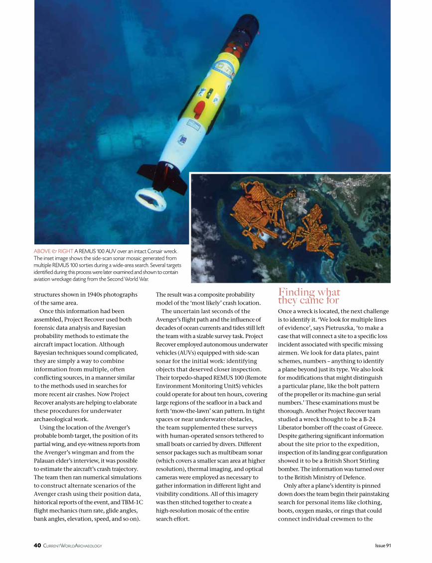
The uncertain last seconds of the Avenger’s flight path and the influence of decades of ocean currents and tides still left the team with a sizable survey task. Project Recover employed autonomous underwater vehicles (AUVs) equipped with side-scan sonar for the initial work: identifying objects that deserved closer inspection. Their torpedo-shaped REMUS 100 (Remote Environment Monitoring UnitS) vehicles could operate for about ten hours, covering large regions of the seafloor in a back and forth ‘mow-the-lawn’ scan pattern. In tight spaces or near underwater obstacles, the team supplemented these surveys with human-operated sensors tethered to small boats or carried by divers. Different sensor packages such as multibeam sonar (which covers a smaller scan area at higher resolution), thermal imaging, and optical cameras were employed as necessary to gather information in different light and visibility conditions. All of this imagery was then stitched together to create a high-resolution mosaic of the entire search effort.
structures shown in 1940s photographs of the same area.
Once this information had been assembled, Project Recover used both forensic data analysis and Bayesian probability methods to estimate the aircraft impact location. Although Bayesian techniques sound complicated, they are simply a way to combine information from multiple, often conflicting sources, in a manner similar to the methods used in searches for more recent air crashes. Now Project Recover analysts are helping to elaborate these procedures for underwater archaeological work.
Using the location of the Avenger’s probable bomb target, the position of its partial wing, and eye-witness reports from the Avenger’s wingman and from the Palauan elder’s interview, it was possible to estimate the aircraft’s crash trajectory. The team then ran numerical simulations to construct alternate scenarios of the Avenger crash using their position data, historical reports of the event, and TBM-1C flight mechanics (turn rate, glide angles, bank angles, elevation, speed, and so on).
above & RIght A RemUs 100 AUV over an intact Corsair wreck. The inset image shows the side-scan sonar mosaic generated from multiple RemUs 100 sorties during a wide-area search. several targets identified during this process were later examined and shown to contain aviation wreckage dating from the second World War.
below Project Recover does not just rely on cutting-edge technology – talking to local communities is also an essential part of their work. Here the Project meets with Papua New guinea elders.
www.world-archaeology.com 41CurrentWorldArChAeology
Spotlight
limited resources, however, DPAA may take years to set up a recovery operation. The ensuing identification process can take more months, depending on the nature of the remains brought back to the lab. Most families do not understand how long it all takes, so scientific reporting by Project Recover is both rare and slow. ‘If we were to report like other archaeologists’, says Pietruszka, ‘it might make it easy for others to identify who that family is.’ Naturally, contact should only occur after there is certain news of relatives and loved ones.
Since its first expedition in 2013, Project Recover has been able to document 13 US aircraft associated with 54 missing crewmen. Most recently, Project Recover surveyed the wreckage of two B-25 Mitchell bombers off the east coast of Papua New Guinea. One was a new discovery involving six missing crewmen. As always, any information about those crewmen will stay confidential until DPAA completes its work. Identification and repatriation, if they come, take time.
In September 2017, the DPAA announced that two of the three crewmen from the 1944 TBM-1C Avenger loss have now been officially accounted for. The remains of Naval Reserve Aviation Radioman 2nd Class Albert ‘Bud’ Rybarczyk were buried in December 2017 and the remains of Aviation Ordnanceman 2nd Class Ora H. Sharninghouse Jr. were buried in April 2018.
Project Recover’s use of technology has opened up opportunities for exploring sites that were once considered impracticable. The team also added aerial drones to their toolset in 2017, providing them with jungle- and mangrove-mapping capabilities. Equipped with infrared sensors, these drones can search over land for metal signatures that could indicate plane debris or grave sites. Alongside such high-tech approaches, talking with local communities remains an essential step. This contact has helped local people to recognise that wreck sites are an important part of their local history. ‘In New Guinea, they were thankful for what we did in the war’, notes Pietruszka, ‘and they revere the Americans who died. This makes local citizens the informal guardians of these sites.’ Adopting such rigorous procedures is also helping to change perspectives on the past more widely. ‘World War II archaeology is becoming more prevalent in the literature,’ Pietruszka adds. ‘Now people recognise it as a cultural resource, not scrap. If locals know about these sites, they’re more likely to be protected for cultural tourism. Some countries are promoting historical diving, and with monetisation comes protection.’
The core mission of Project Recover nevertheless imposes some unique constraints after an expedition returns. Living people can be affected by the information brought back from a wreck site, so the team’s records are largely kept confidential until the identity of a missing airman is officially released by DPAA. With
wreck. ‘Most are just fragments buried in the sand,’ says Pietruszka. Even though items are scattered after decades in the ocean, their context is still important for later evaluation. Divers photograph and record everything they find. The last step of Project Recover fieldwork is its most valuable – delivery of their documentation. With limited resources, DPAA requires solid evidence to justify an expedition. Good data increases the likelihood that DPAA will conduct a recovery operation, and that it will be successful when they do. DPAA staff includes forensic anthropologists and archaeologists who are capable of assessing a wide range of evidence, including DNA, even after decades in the sea.
On 24 March 2014, almost 70 years after the USS Intrepid air strike, Project Recover found the missing TBM-1C Avenger in 26m of water and, after the team delivered its report, DPAA began efforts to organise a recovery operation.
Opportunities and constraintsBoth the tools and the methods used by Project Recover are expanding the capabilities available to underwater archaeologists, and Pietruszka believes that their techniques can effectively transfer to other kinds of sites. ‘These same practices and principles can be applied to, say, ancient Greek or Phoenician wrecks,’ he says. Indeed, Project Recover expeditions have occasionally encountered and documented shipwrecks. Underwater sites are difficult to explore, which means that maritime wrecks are often far less disturbed than their land-based counterparts. Still, these sites do not last forever, so Project Recover uses their digital imaging and measuring equipment to create snapshots in time, which are available for later analysis in a process that Terrill calls ‘digital preservation’.
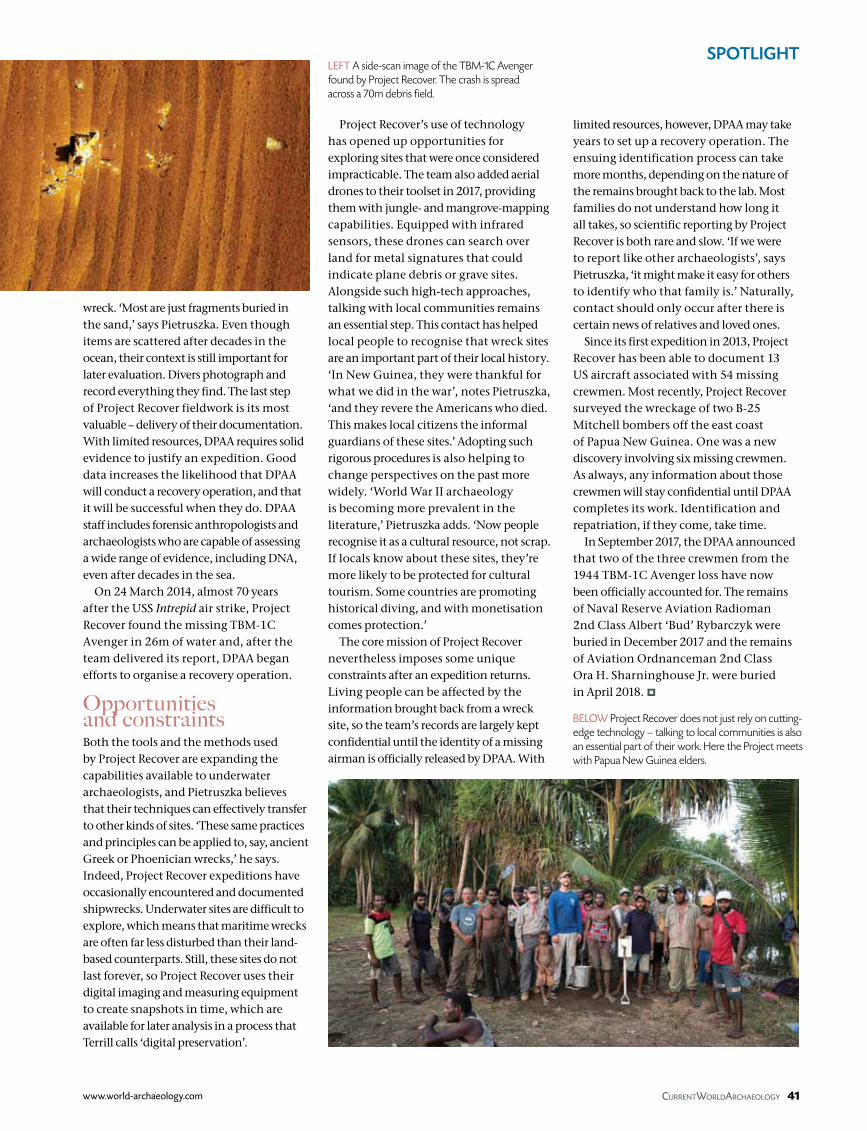
left A side-scan image of the TBm-1C Avenger found by Project Recover. The crash is spread across a 70m debris field.