Understanding Design, Tolerating Ambiguity, and Developing ...
Under the Jungle - Geo Karst challenge - Sunday June 21
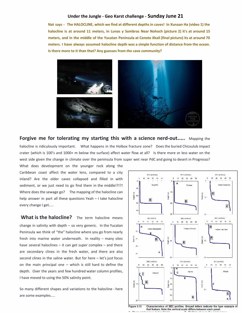
Nat says - The HALOCLINE, which we find at different depths in caves! In Xunaan Ha (video 1) the
halocline is at around 11 meters, in Lunas y Sombras Near Nohoch (picture 2) it's at around 15
meters, and in the middle of the Yucatan Peninsula at Cenote Xkail (final picture) its at around 70
meters. I have always assumed halocline depth was a simple function of distance from the ocean.
Is there more to it than that? Any guesses from the cave community?
Forgive me for tolerating my starting this with a science nerd-out….. Mapping the
halocline is ridiculously important. What happens in the Holbox fracture zone? Does the buried Chicxulub impact
crater (which is 100’s and 1000+ m below the surface) affect water flow at all? Is there more or less water on the
west side given the change in climate over the peninsula from super wet near PdC and going to desert in Progresso?
What does development on the younger rock along the
Caribbean coast affect the water lens, compared to a city
inland? Are the older caves collapsed and filled in with
sediment, or we just need to go find them in the middle!?!?!
Where does the sewage go? The mapping of the halocline can
help answer in part all these questions Yeah – I take halocline
every change I get….
What is the halocline? The term halocline means
change in salinity with depth – so very generic. In the Yucatan
Peninsula we think of “the” halocline where you go from nearly
fresh into marine water underneath. In reality – many sites
have several haloclines – it can get super complex – and there
are secondary clines in the fresh water, and there are also
second clines in the saline water. But for here – let’s just focus
on the main principal one – which is still hard to define the
depth. Over the years and few hundred water column profiles,
I have moved to using the 50% salinity point.
So many different shapes and variations to the halocline - here
are some examples….

The water above the halocline comes from rainwater (meteoric
water) and we call that the Fresh Water Lens, but some biologist
have been getting picky since it does have some salt in it, so they
have been calling it a Brackish Lens. Maybe at some conference
we will duke that out over beers…. And settle on Meteoric Lens
which is technically more correct, but harder to understand. This
is some of the heavy lifting that nerds do at conferences.
The fresher rainwater literally sits on top of the saline water
underneath - and pushes it down. The overall shape is like a lens.
What is the Yucatan halocline / fresh water lens geography?
The halocline in QR is about 5 m depth at the coast e.g. at Casa Cenote – that is why there is room for fresh water to be
pushed out through the “discharge face”.
It gets progressively deeper as you go inland – BUT
there is a lot of site to site variability. .
And – there is practically no data for the middle,
north, and west side of the peninsula. We need more
of you guys to dive the cenotes in Yucatan State
please – but you will need to have an instrument with
you ideally although I am more than happy to take
visual observations. Your eyeballs are powerful
instruments!!!!! 😊
Where does the salt water end?
The intruding marine water goes right underneath the
whole peninsula. A number of researchers have tried
to find where the salt water end, but this is super odd
to me since in small islands we know the saline water
goes across underneath. It goes underneath in larger
islands…. And so with very thick limestone under the
whole peninsula, there is nothing that would stop it,
and so IMO of course it has always gone right across.
Indeed in sub-marine carbonate platforms of this size
that have been drilled for oil – the marine water goes
right through.
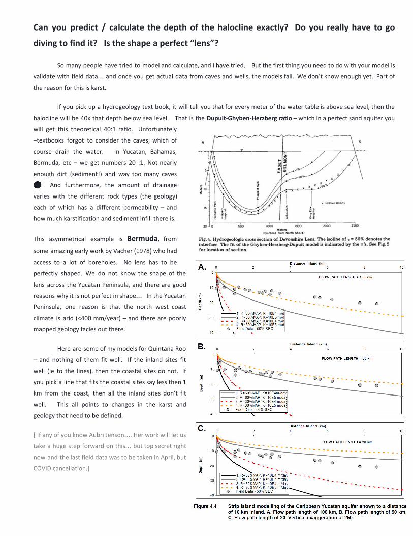
Can you predict / calculate the depth of the halocline exactly? Do you really have to go
diving to find it? Is the shape a perfect “lens”?
So many people have tried to model and calculate, and I have tried. But the first thing you need to do with your model is
validate with field data… and once you get actual data from caves and wells, the models fail. We don’t know enough yet. Part of
the reason for this is karst.
If you pick up a hydrogeology text book, it will tell you that for every meter of the water table is above sea level, then the
halocline will be 40x that depth below sea level. That is the Dupuit-Ghyben-Herzberg ratio – which in a perfect sand aquifer you
will get this theoretical 40:1 ratio. Unfortunately
–textbooks forgot to consider the caves, which of
course drain the water. In Yucatan, Bahamas,
Bermuda, etc – we get numbers 20 :1. Not nearly
enough dirt (sediment!) and way too many caves
😊 And furthermore, the amount of drainage
varies with the different rock types (the geology)
each of which has a different permeability – and
how much karstification and sediment infill there is.
This asymmetrical example is Bermuda, from
some amazing early work by Vacher (1978) who had
access to a lot of boreholes. No lens has to be
perfectly shaped. We do not know the shape of the
lens across the Yucatan Peninsula, and there are good
reasons why it is not perfect in shape… In the Yucatan
Peninsula, one reason is that the north west coast
climate is arid (<400 mm/year) – and there are poorly
mapped geology facies out there.
Here are some of my models for Quintana Roo
– and nothing of them fit well. If the inland sites fit
well (ie to the lines), then the coastal sites do not. If
you pick a line that fits the coastal sites say less then 1
km from the coast, then all the inland sites don’t fit
well. This all points to changes in the karst and
geology that need to be defined.
[ If any of you know Aubri Jenson…. Her work will let us
take a huge step forward on this… but top secret right
now and the last field data was to be taken in April, but
COVID cancellation.]
How is the depth of the halocline used?
The government management agencies rely heavily on the standard general hydrogeology textbooks. Based on the textbook
equation, they calculate that every time the water table goes up, they use the 40:1 calculation, and figure they have 40x more
water in the system.
First of all – they need to be using ~20 : 1 and not 40 – because…. Karst.
Second of all – there is a lot of friction in the system so the water needs time to move around. The halocline is a “soft” and
deformable lower boundary, but it does not jump around instantaneously. If there is more fresh water loaded on top by rain, it
pushes down on the salt water which then has to get squeezed out to the coast - all at the same time some of the fresh water is
draining out too - reducing the loading.
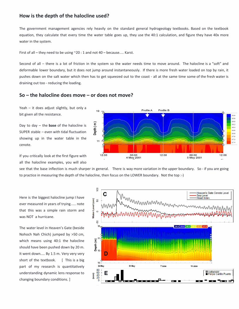
So – the halocline does move – or does not move?
Yeah – it does adjust slightly, but only a
bit given all the resistance.
Day to day – the base of the halocline is
SUPER stable – even with tidal fluctuation
showing up in the water table in the
cenote.
If you critically look at the first figure with
all the halocline examples, you will also
see that the base inflection is much sharper in general. There is way more variation in the upper boundary. So - if you are going
to practice in measuring the depth of the halocline, then focus on the LOWER boundary. Not the top :-)
Here is the biggest halocline jump I have
ever measured in years of trying….. note
that this was a simple rain storm and
was NOT a hurricane.
The water level in Heaven’s Gate (beside
Nohoch Nah Chich) jumped by >50 cm,
which means using 40:1 the halocline
should have been pushed down by 20 m.
It went down…. By 1.5 m. Very very very
short of the textbook. [ This is a big
part of my research is quantitatively
understanding dynamic lens response to
changing boundary conditions. ]
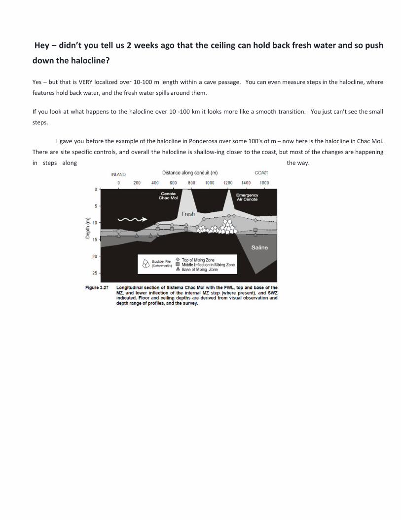
Hey – didn’t you tell us 2 weeks ago that the ceiling can hold back fresh water and so push
down the halocline?
Yes – but that is VERY localized over 10-100 m length within a cave passage. You can even measure steps in the halocline, where
features hold back water, and the fresh water spills around them.
If you look at what happens to the halocline over 10 -100 km it looks more like a smooth transition. You just can’t see the small
steps.
I gave you before the example of the halocline in Ponderosa over some 100’s of m – now here is the halocline in Chac Mol.
There are site specific controls, and overall the halocline is shallow-ing closer to the coast, but most of the changes are happening
in steps along the way.