
EVALUATION OF LAND USE WITH LAND CAPABILITY CLASSIFICATION …

Forestry Commission
ARCHIVE


Land Capability for Forestry in
South-East Scotland
by F.T Dry and J.A. Hipkin
Contents
1. The land capability classification for forestry 2
2. The classes in South-East Scotland 7
3. References 21
4. Table of areas 22
Acknowledgements 24
Produced for the Forestry Commission by the M acaulay Land Use Research Institute
© The Macaulay Land Use Research Institute, Aberdeen, 1989
ISBN 0 85538 228 7
f r o n t c o v e r : Glentress (Forestry Commission photo)
1

L A N D C A P A B I L I T Y F O R F O R E S T R Y
1. The land capability classification for forestry
The land capability classification for forestry is based on an assessment of the degree of limitation imposed by the physical factors of soil, topography and climate on the growth of trees and on silvicultural practices. The principal tree species considered are those broadleaves and conifers commonly grown in Britain, and the classification assumes a skilled management level that will include cultivation, drainage, fertiliser application and weed control where these are necessary.
The principles on which the classification is based and the guidelines for assessing each type of limitation are described in Land Capability Classification for Forestry in Britain (Bibby et al. 1988).
TYPES OF LIMITATION
The classification is based on seven types of limitation, these being climate, windthrow, nutrients, topography, droughtiness, wetness and soil.
Climate
Climate is probably the most important factor that affects afforestation in Britain and it provides the framework of the classification. The two principal elements are accumulated temperature, measured in day- degrees above 5.6°C (Birse and Dry 1970, Birse 1971) and exposure, measured in mean annual wind speeds (Birse and Robertson 1970). Rainfall is of less importance, since in Britain it is sufficient for tree growth provided the soil is capable of storing the moisture it receives. Seasonal frosts can affect tree growth and species choice, but their occurrences depend very much on the local topography.
2

S O U T H - E A S T S C O T L A N D
Windthrow
The likelihood of windthrow in forests affects both forest management and timber production, since in areas of high risk, thinning is precluded and crop rotations shortened. Windthrow is likely to occur where soils with shallow rooting depths are found in combination with a high degree of exposure and high wind speeds. The assessment of risk, described by Miller (1985), is done on a point-scoring system which takes into account wind zone, elevation zone, topographic exposure and soil type. From the total score, the windthrow hazard class, of which there are six, is derived; low scores indicate a low hazard class and a low risk of windthrow.
Nutrients
Although the application of fertilisers, principally phosphorus and potassium, is part of regular forest practice, the natural availability of nutrients in the soil determines very largely the choice of species that can be grown. In organic soils, nutrient availability, related to the total content of nitrogen, phosphorus and potassium, is low except where considerable surface flushing has taken place. Mineral soils are usually more fertile, particularly those that have been used regularly for arable rotations. Their nutrient availability is related to the volume of soil available for rooting and the chemical composition of the soil parent material, those derived from acid rocks such as quartzites and granites being poorest. However, on soils developed on materials derived from basic igneous rocks, problems of poor phosphorus availability can arise, and on ultrabasic rocks, growth problems associated with high magnesium or nickel are likely.
Topography
Topography principally affects the mechanised operations necessary for the establishment and harvesting of the tree crop and the design and construction of forest roads. Slope is the major element. Two-way ploughing is generally only possible on slopes of less than 5° and trailed ploughs are mainly confined to slopes less than 18°. One-way ploughing with mounted plough reaches a limit at 35° on dry stable slopes but is less than this on wet slopes or where there is a danger of the soil layer parting
3

L A N D C A P A B I L I T Y F O R F O R E S T R Y
from the underlying rock and the tractor 'rafting' downhill. On irregular, rocky or bouldery topography these limits can be reduced considerably, and complete ploughing may be precluded.
Droughtiness
Droughtiness affects forestry capability in areas where soils with very low water-holding capacity, such as dune sands, occur under low rainfall. Where water is in short supply to the root, a number of problems can occur, particularly at establishment, which are partly physiological and partly nutritional. High soil moisture deficits can result in reduced yields and restrict the choice of species.
Wetness
Soil wetness is a physiological barrier to root growth and its implications for forestry are that it can lead to poor growth due to poor aeration, low soil temperatures and a restricted amount of soil exploitable for nutrients, as well as reducing tree stability and thus increasing windthrow risk, particularly in exposed upland areas. Seasonal saturation of the root zone occurs widely in surface-water gleys. Such soils, together with peats and peaty gleys, require drainage schemes. Sites which are subject to regular flooding are not suitable for afforestation.
Soil
Soil is an important factor in most of the types of limitation so far described, but in some circumstances it can be the dominant one affecting forestry capability. Shallow soils, for example, have restricted rooting depths and can be difficult to plough; trafficking on them can result in topsoil destruction. In areas where soil patterns are complex, site preparation and treatments appropriate to each soil type may not be easy and compromises will have to be reached.
4

S O U T H - E A S T S C O T L A N D
THE CLASSES
Class F I. Land with excellent flexibility for the growth and management o f tree crops
The soils are deep and well supplied with moisture, and neither climate nor site factors seriously restrict the growth of the main tree species used in Britain. A wide range of broadleaved and coniferous species can be planted.
Class F2. Land with very good flexibility for the growth and management o f tree crops
The soils have no or only limited periods of seasonal waterlogging, but some mineral gleys may be included if, with drainage, the water-table can be controlled at depths which prevent serious waterlogging of the root system. Minor areas of shallower or wetter soils are acceptable but should not exceed 10% in total. Minor restrictions on cultivation and harvesting due to slopes or minor climatic restraints are also acceptable. Both broadleaved and coniferous species may be planted but choice is more restricted than in Class F I . In areas where available water is limited, those species with high water demand are unsuitable; in areas with water surplus soil drainage may be necessary.
Class F3. Land with good flexibility for the growth and management o f tree crops
The soil range extends to include mineral gleys with sandy or loamy textures and flushed gleys with humose topsoils. Drainage is necessary on gley soils. Windthrow risk is not high and land management is primarily concerned with limitations imposed by drainage, sloping land or patterns of variable soils. The land is suitable for a wide range of conifers and for a restricted range of broadleaved species.
Class F4. Land with moderate flexibility for the growth and management o f tree crops
The soils include the more fertile peaty soils and the problem mineral soils, e.g. gleys with clayey textures or soils with calcareous horizons.
5

L A N D C A P A B I L I T Y F O R F O R E S T R Y
Ploughing difficulty maybe encountered due to stony or shallow soils but this should not be more than 20% of the area. There is a risk of small areas of windthrow which should not be sufficiently severe to reduce rotation lengths or influence management practices. The land is suitable for many coniferous species and in places for the less demanding broadleaves.
Class F5. Land with limited flexibility for the growth and management o f tree crops
The soils are primarily podzols, peaty gleys and peat, but where limitations are sufficiently severe to limit species selection, other soils may be included. Ploughing is possible but may be more difficult than in the previous classes. Sites in which the risk of windthrow affects management by modifying the thinning practice fall within this class. In the uplands species choice is limited to conifers, such as spruces, larches and pines, and to birch, alder or other hardy broadleaves.
Class F6. Land with very limited flexibility for the growth and management o f tree crops
The principal limitations are adverse climate and poor soil conditions. The soils include podzols, peaty gleys and peats, and soils affected by toxicities. Sites on which the risk of windthrow effectively prevents thinning and seriously curtails the rotation length, and sites with very severe surface terrain which imposes great difficulty in ploughing or extraction, fall within this class. Species choice is limited to lodgepole pine and Sitka spruce and to amenity broadleaves such as birch and alder.
Class F7. Land unsuitable for producing tree crops Land is considered unplantable if its physical characteristics preclude the growth or establishment of tree crops by normal methods. These characters include extremes of climate (orohemiarctic and oroarctic climate zones over extremely exposed sites), wetness (flow-bog or flood sites), rockiness and extreme slopes.
6

S O U T H - E A S T S C O T L A N D
2. The classes in South-East Scotland
This handbook describes the classes shown on the 1:250 000 scale land capability for forestry map Sheet 7 (South-East Scotland), which represents a land area of 19 775 sq km. The geology, landscapes, soils, vegetation, agriculture and agricultural potential of the region have been detailed in Bown and Shipley (1982).
The physiographic character of the region is strongly related to the geology. Two major fault lines, both trending south-west to north-east, and comprising the Highland Boundary Fault to the north-west and the Southern Uplands Fault which bisects the area, have created three principal landform divisions, the Highlands, the Midland Valley, and the Southern Uplands. The Highlands division, lying to the north of the Highland Boundary Fault, is a rugged, mountainous area and includes Ben Venue, Ben Ledi and Ben Vorlich. The scenery of the Midland Valley is by contrast less dramatic; much is undulating lowland based on sedimentary rocks overlain by thick deposits of glacial till, but locally more resistant igneous rocks give rise to prominent hill ranges, the Kilpatrick Hills, the Campsie Fells, the Ochil Hills and the Pentland Hills. The Southern Uplands Fault is the northern boundary of the Southern Uplands division and is marked by steeply rising terrain underlain by greywackes and shales. The close relationship of landforms and soils to the geology and the geomorphic history of the major physiographic features is well illustrated in the Southern Uplands. The rounded hills of the Lowther, Tweedsmuir, Moorfoot and Lammermuir Hills with their smooth, steep slopes typify the greywacke and shale country of the central and eastern Uplands. West of the River Nith the hills become more rugged and the slopes less smooth, but it is on the Galloway granites of Loch Doon-Loch Dee, Cairnsmore of Fleet, Criffel and Cairnsmore of Carsphairn that the most rugged and rocky landforms occur. Lowland areas within the Southern
7

L A N D C A P A B I L I T Y F O R F O R E S T R Y
Uplands, the Lochmaben basin, the Solway plain and the Merse of Berwick, are based on sedimentary rocks less resistant to erosion and generally overlain by thick deposits of glacial till. The landscape is undulating, locally strongly so with drumlins.
The principal limitations on the land capability for forestry in South- East Scotland are climate, windthrow hazard, nutrient status and topography and only locally do the limitations imposed by droughtiness, wetness or soil determine the class. Limitations due to climate relate strongly to altitude, aspect, prevailing wind and proximity of the sea. The influence of windthrow hazard on land capability assessment increases in the more windy south-west and west of the area and particularly on open, exposed landscapes with poorly draining soils. All seven land capability for forestry classes are represented in South-East Scotland.
Classes FI, F2 and F3 are confined to lowland areas within the Midland Valley and Southern Uplands. Climate is the principal determining factor. Class F4, more widespread, is found in lowland areas with poorly draining mineral gley soils, in exposed lowland sites where the windthrow hazard risk is limiting, and along coastal fringes. It also occurs on the footslopes of the hills where climate or wetness are the main limiting factors. The distribution of Class F5 land is related mainly to altitude and an increasingly adverse climate, to lands where peaty- topped but flushed soils dominate, to increased windthrow hazard risk and to adverse topography. Adverse climate or low nutrient status of the soils are the principal limitations in Class F6; locally windthrow hazard risk determines the class. Climate is the main factor determining the distribution of Class F7 land.
Forestry is well established in the area and particularly so in the Highlands division by Aberfoyle and in the south-western and central parts of the Southern Uplands at Glen Trool, Ae, Eskdalemuir, Craik, Wauchope and by Peebles and Innerleithen. Planting has also been carried out in the hills and uplands of the western and central Midland Valley by Muirkirk, Cumnock, Darvel and Forth. Forestry is far less extensive in the east. The woodlands here, generally associated with the policy grounds of the major castles and houses of the area, are often broadleaved, with good stands of oak at the Hirsel and at Floors Castle,
8

Plate 1. Class FI,Tweed valley near Coldstream. The amenable climate and the high nutrient status of the soils provide excellent conditions for the growth and management of a wide range o f broadleaves and conifers. (Photo: MLURI)
Plate 2. Class F3, with Class F2 in the sheltered valley in the foreground,Tweed valley near Melrose. A range of opportunities is available for the growth and management of broadleaves and conifers. (Photo: MLURI)

L A N D C A P A B I L I T Y F O R F O R E S T R Y
and of beech at Marchmont, Duns Castle, Mellerstain and Tyninghame. The use of woodland as shelterbelt is common.
Class FI. Land with excellent flexibility for the growth and management o f tree cropsArea: 417 sq km
The climate in Class FI land is warm and moderately dry, while exposure is no more than moderate, with a mean annual wind speed of less than 4 m/s. The land is level or undulating with gentle slopes. The soils are deep and well supplied with moisture and nutrients, loamy and freely or imperfectly draining, and.offer no restriction to rooting. Windthrow risk is low, windthrow hazard class 1 or 2. Neither climate nor site factors seriously affect species choice, restrict growth or limit mechanised forestry operations.
The class is not extensive and occurs locally throughout the area, principally in Strath Earn by Auchterarder, Strath Eden by Cupar in Fife, Fladdington in the valley of the Tyne, the valleys of the Tweed and Whiteadder in the Merse of Berwickshire, the valley of the Clyde by Lanark, and in the upper more sheltered valley of the Annan by Lochmaben. The land can support a wide range of broadleaved and coniferous species.
Class F2. Land with very good flexibility for the growth and management o f tree cropsArea: 2551 sq km
Class F2 land occurs extensively in Berwickshire and Roxburghshire, especially in the Merse, around St. Boswells, Duns and Chirnside, in East Lothian around Tranent and East Linton, and in West Lothian around Linlithgow. Other areas include parts of Fife, Falkirk and Strathkelvin, the area around Drymen and Balfron, in Strathallan around Dunblane, around Dumfries and Nithsdale, and around Lockerbie and Annandale. This land also extends along valleys such as those of the River Clyde at Lanark and the River Tweed at Melrose.
1 0

S O U T H - E A S T S C O T L A N D
The land comprises undulating lowlands with gentle slopes, and alluvial plains, and rises to an altitude of about 110 m. The climate is warm, moderately dry and moderately exposed with a mean annual wind speed of less than 4.4 m/s. Minor climatic restraints such as slightly lower accumulated temperatures and higher wind speeds are the main factors which make this land less productive and restrict the choice of species slightly more than in Class FI. The risk of windthrow is low, the windthrow hazard class being generally not worse than 3, although small areas (less than 10%) of higher hazard classes occur, for example, in wetter or more exposed sites.
The nutrient status of the soils is generally high as most of this land has been utilised for arable farming systems for a considerable time. The soils are predominantly freely and imperfectly draining brown forest soils with textures of sandy silt loam in the topsoil and clay loam in the subsoil, although sandy loam superficial deposits from 60 to 75 cm thick commonly overlie the fine-textured material, as in the area around Whitsome in the Tweed valley. These soils provide a moisture-retentive growing medium with good rooting depth. Areas of poorly draining noncalcareous gleys occur in depressions, but they are usually small. Alluvial soils in the major valleys also provide good growing conditions.
A wide range of broadleaved and coniferous species can be planted on this land. Most of the area is farmed, with trees confined to the policy grounds of estates such as around Drumlanrig Castle, Mellerstain, Rutherford and the Hirsel. Elsewhere trees are grown as shelterbelts and also occur along river valleys.
Class F3. Land with good flexibility for the growth and management o f tree crops
Area: 3001 sq km
Class F3 land occurs most extensively in the Ayrshire plain around Kilmarnock, in East Lothian as a coastal fringe and bordering the Lammermuir Hills, in east Fife, in Lauderdale, in the Border lowlands around Greenlaw and Smailholm, in lower Tweeddale by Ancrum, Jedburgh and to the south-east of Kelso, and around Lanark in the upper valley of the Clyde. It is found less extensively in Dumfries and Galloway,
11

Plate 3. Class F3 on the alluvial flats and Classes F4 and F5 on the steep valley sides in Eskdale near Langholm. (Photo: MLURI)
Plate 4. Class F4, Nithsdale. A range of conifers can be grown but broadleaves are limited by climate to the less demanding species. (Photo: MLURI)
w m ,
iW'jeSm

Plate 5. Classes F5, F6 and F7 near Loch Dee. The land in the foreground and middle distance is suited to conifers although topographic pattern will affect site preparation and harvesting. The higher rocky land is unsuitable for planting. (Photo: MLURI)
Plate 6. Class F5 on flushed peat in the Pentland Hills, suited to conifers. (Photo: MLURI)

L A N D C A P A B I L I T Y F O R F O R E S T R Y
principally on sheltered valley lower slopes and on the Solway plain. The land comprises the lower hill slopes and gently and strongly undulating lowlands, and rises to an altitude of about 200 to 220 m.
Climate is the main limitation on species choice and growth. It is fairly warm and moderately dry. Exposure is generally only moderate, with a mean annual wind speed of less than 4.4 m/s, but the more exposed coastal areas of East Lothian and the exposed but warmer west and south-west of the area are also included in the class. The soils are mainly brown forest soils, brown forest soils with gleying, and noncalcareous gleys with fine loamy or coarse loamy textures. The brown forest soils with gleying are developed on fine-textured glacial tills and have slowly permeable subsoils, but rooting depths are usually greater than 40 cm. The windthrow risk is not high, the hazard class being normally not worse than class 3. The nutrient status of the soils is generally high as most of the lands have been utilised for arable farming systems for a considerable time. Drainage is necessary on the gleyed soils. Locally steep or irregular slopes will restrict mechanised operations. The land is suitable for a wide range of conifers and for a restricted range of broadleaved species.
Class F4. Land with moderate flexibility for the growth and management o f tree cropsArea: 3930 sq km
Class F4 land occurs extensively in the foothill areas of the Southern Uplands at altitudes of about 200 to 250 m, and also in the undulating plains of central Ayrshire, West Lothian and Lanarkshire, and in the Carse of Stirling. More confined areas occur along the exposed coastlines of the Solway Firth, East Lothian and north-east Fife, and along some of the major valleys.
The climate is generally fairly warm and moderately dry, but tends to be warm and wet in the south-west. Wind speeds are in the range 4 to 6 m/s, being higher near exposed coasts and hills, and lower in sheltered valleys and depressions. Thus, climate is an important influence especially where increasing altitude and exposure adversely affect accumulated temperature and wind speed, and will be the only limiting factor in areas
1 4

S O U T H - E A S T S C O T L A N D
dominated by deep, freely draining brown forest soils on slopes of less than 18°. On steeper slopes, for example in Lauderdale, the Lammermuir Hills, the upper Clyde valley and Nithsdale, topography is the limiting factor.
The windthrow hazard class is usually no greater than 4, although small areas of higher risk may be included. The risk of windthrow is considered to be the main limiting factor where soil conditions impede root growth, and exposure and wind speed are high, as on the Slamannan plateau south-east of Cumbernauld. Nutrient supplies are generally sufficient on the mineral soils but may require to be supplemented on the peaty soils, particularly on establishment.
In areas of Dumfries and Galloway and around Hawick, a pattern of slopes, shallow soils and rock outcrops affects ploughing and subsequent forest management. In an area near New Galloway, brown forest soils occur on drumlins and peat occurs in the intervening hollows; this complex pattern of topography and soils is represented as Class 4/5 on the 1:250 000 scale land capability for forestry map. Soil wetness is the main limiting factor in the Carse of Stirling and in parts of West Lothian, Lanarkshire and Ayrshire where poorly draining clayey and silty noncalcareous gleys and flushed peaty gleys predominate.
In land designated as Class F4 the choice of species is limited to conifers and the less-demanding broadleaves.
Class F5. Land with limited flexibility for the growth and management o f tree cropsArea: 4061 sq km
Class F5 encompasses a wide range of land types, and is recognised at altitudes up to around 330 m. Climate, soil type and wetness, windthrow risk, topography, nutrient status and droughtiness all play, individually or collectively, major roles in determining the distribution of the class.
Climate is the factor limiting the capability of the steep, smooth upper slopes typical of the central and eastern Southern Uplands and of local valley slopes in the Highlands. The soils are brown forest soils or a mosaic of brown forest soils, humus-iron podzols and flushed gleys, with
1 5

Plate 7. Class F6, with Class F5 on better soils in the more sheltered valley bottoms, Wauchope Forest near Hawick. Climate restricts species choice to conifers, although hardy broadleaves such as birch could be grown. (Photo: MLURI)
Plate 8. Class F7,Moorfoot Hills. The severe climate, particularly the exposure to strong winds, precludes afforestation of the higher land in South-East Scotland. (Photo: MLURI)

S O U T H - E A S T S C O T L A N D
no outcropping rock or scree. Climate also limits the capability of sheltered land with poorly draining noncalcareous gleys.
Windthrow risk is high (hazard class 5) and limiting where windy and exposed situations are found in combination with poorly draining gleys with compact clayey subsoils. Such lands occur in both upland and lowland, being extensive on higher plateaux of the Midland Valley, for example Auchterhead Muir between Shotts and the village of Forth.
In areas of Galloway, by Castle Douglas and Kirkcudbright and in Teviotdale, by Hawick in Borders Region, the landscape is rock-controlled and highly irregular with a complex and intricate pattern of brown forest soils, brown rankers and rock or boulders. Adverse topography resulting from short-range variation in soils, slope and rockiness, imposes limitations sufficient to determine the class. Trees are easily established and grow readily on the freely draining mineral soils, but outcropping rock hampers mechanised operations.
Near New Galloway, widely scattered drumlins with brown forest soils occur with intervening tracts of deep flushed peat. These areas are represented on the 1:250 000 land capability for forestry map as F5/4, the peat land being Class F5 and the brown forest soils Class F4. Locally, in the Southern Uplands, and particularly to the west of Moniaive, valley sides are concave rather than the more usual convex. The pattern of soil and land type is complex, with flushed gleys on receiving slopes and brown forest soils on steep, often bouldery, shedding slopes. This intricate pattern of soil and topography restricts species choice and determines the class.
Soil nutrient deficiency is the principal factor limiting the capability of land with peaty gleys or flushed peat and occurring in sheltered sites where windthrow hazard is not limiting. Such lands occur widely in the valleys of the Ken and Deugh Waters in Galloway.
In the drier east, lands with freely or excessively draining sandy soils with low water-retention capacities are liable to be subject to drought. At Tentsmuir Forest and Gullane Links the limitations imposed by potential drought are sufficiently severe to determine the class. On highly calcareous sands, nutrient imbalance may be an additional restriction.
1 7

L A N D C A P A B I L I T Y F O R F O R E S T R Y
On lands dominated by peaty gleys heather (Calluna vulgaris)is a principal component of the vegetation and in the early stages of tree growth can cause serious check to spruce.
Species choice in Class 5 land is limited mainly to conifers, such as spruces, larches and pines and to birch, alder or other hardy broadleaves.
Class F6. Land with very limited flexibility for the growth and management o f tree cropsArea: 3859 sq km
Class F6 land, extensive at altitudes between 330 m and 450 m, includes all the main upland areas such as the Lammermuir, Moorfoot, Tweedsmuir and Lowther Hills, the Trossachs, the area around Merrick and Cairnsmore of Fleet, and areas of unflushed peaty gleys and peat on the high plateaux of the Midland Valley and in Eskdalemuir. In the lowlands raised mosses such as Flanders Moss in the Carse of Stirling, Lochar Moss near Dumfries, and small areas of unflushed peat are also designated as Class F6. Adverse climate and poor soil conditions are the principal limitations.
The climate in the upland areas is cold, wet and exposed, with wind speeds around 6 m/s. In areas where freely draining humus-iron podzols or brown forest soils occur, climate is the main limiting factor. In the more exposed areas with very restricted rooting due to wet peaty soils or peat, the high risk of windthrow is the main limitation (windthrow hazard class 6). The soils are inherently low in nutrients, especially the very poorly draining unflushed organic soils. Locally, steep slopes or very rocky land may impose limitations on forestry operations, although planting without mechanised ground preparation may be an option. Such sites occur throughout the area, for example near the Grey Mare's Tail in the valley of the Moffat Water and around Loch Trool and Clatteringshaws Loch.
The choice of species is limited to lodgepole pine, Sitka spruce and hardy broadleaves such as birch and alder. Fertiliser applications will be necessary on most of the soils, especially the unflushed acid peats. The vegetation of much of the uplands is dominated by heather (Calluna vulgaris) which can check the growth of young spruce crops.
1 8

S O U T H - E A S T S C O T L A N D
Class F7. Land unsuitable for producing tree crops Area: 904 sq km
Climatic extremes determine that lands above altitudes of 450 to 500 m be regarded as Class F7. The lands are associated with peaty podzols, peaty rankers, peat and subalpine soils. Occurrence of this class at lower altitudes is local and reflects extremes of rockiness and slope.
19

L A N D C A P A B I L I T Y F O R F O R E S T R Y
2 0

S O U T H - E A S T S C O T L A N D
3. References
Bibby, J.S., Heslop, R.E.F. and Hartnup, R. 1988. Land Capability Classification for Forestry in Britain. Soil Survey Monograph. The Macaulay Land Use Research Institute, Aberdeen.
Birse, E.L. 1971. Assessment of Climatic Conditions in Scotland. 3. The Bioclimatic Sub-Regions. The Macaulay Institute for Soil Research, Aberdeen.
Birse, E.L. and Dry, F.T. 1970. Assessment of Climatic Conditions in Scotland. 1. Based on Accumulated Temperature and Potential Water Deficit. The Macaulay Institute for Soil Research, Aberdeen.
Birse, E.L. and Robertson, L. 1970. Assessment of Climatic Conditions in Scotland. 2. Based on Exposure and Accumulated Frost. The Macaulay Institute for Soil Research, Aberdeen.
Bown, C.J. and Shipley, B.M. 1982. South-East Scotland: Soil and Land Capability for Agriculture.The Macaulay Institute for Soil Research, Aberdeen.
Miller, K.F. 1985. Windthrow Hazard Classification. Forestry Commission Leaflet 85. HMSO, London.
21
L A N D C A P A B I L I T Y F O R F O R E S T R Y
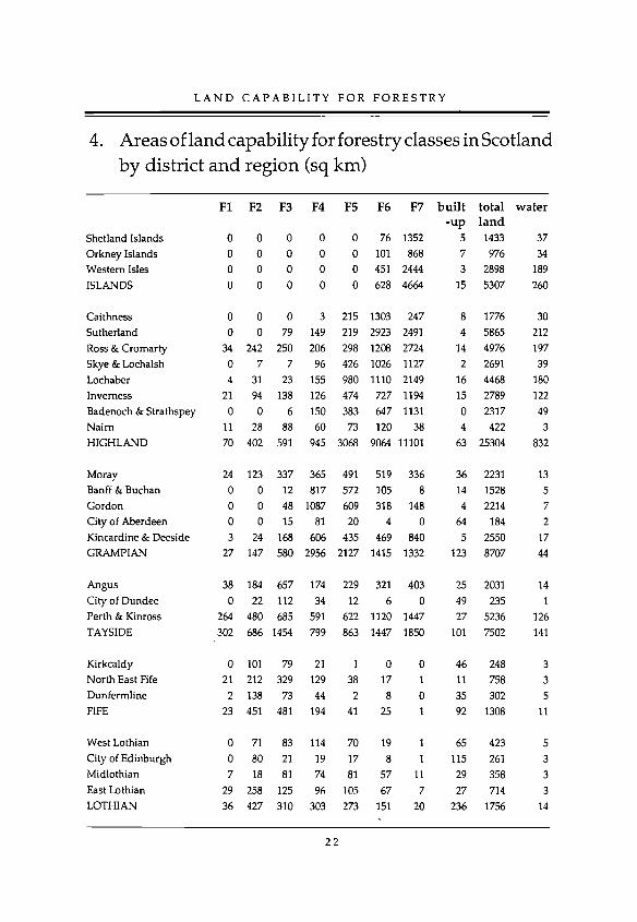
4. Areas of land capability for forestry classes in Scotland by district and region (sq km)
FI F2 F3 F4 F5 F6 F7 b u i l t-u p
to ta lla n d
w a te r
Shetland Islands 0 0 0 0 0 76 1352 5 1433 37
Orkney Islands 0 0 0 0 0 101 868 7 976 34
Western Isles 0 0 0 0 0 451 2444 3 2898 189
ISLANDS 0 0 0 0 0 628 4664 15 5307 260
Caithness 0 0 0 3 215 1303 247 8 1776 30
Sutherland 0 0 79 149 219 2923 2491 4 5865 212
Ross & Cromarty 34 242 250 206 298 1208 2724 14 4976 197
Skye & Lochalsh 0 7 7 96 426 1026 1127 2 2691 39
Lochaber 4 31 23 155 980 1110 2149 16 4468 180Inverness 21 94 138 126 474 727 1194 15 2789 122
Badenoch & Strathspey 0 0 6 150 383 647 1131 0 2317 49Naim 11 28 88 60 73 120 38 4 422 3HIGHLAND 70 402 591 945 3068 9064 11101 63 25304 832
Moray 24 123 337 365 491 519 336 36 2231 13Banff & Buchan 0 0 12 817 572 105 8 14 1528 5Gordon 0 0 48 1087 609 318 148 4 2214 7City of Aberdeen 0 0 15 81 20 4 0 64 184 2Kincardine & Deeside 3 24 168 606 435 469 840 5 2550 17GRAMPIAN 27 147 580 2956 2127 1415 1332 123 8707 44
Angus 38 184 657 174 229 321 403 25 2031 14City of Dundee 0 22 112 34 12 6 0 49 235 1Perth & Kinross 264 480 685 591 622 1120 1447 27 5236 126TAYSIDE 302 686 1454 799 863 1447 1850 101 7502 141
Kirkcaldy 0 101 79 21 1 0 0 46 248 3North East Fife 21 212 329 129 38 17 1 11 758 3Dunfermline 2 138 73 44 2 8 0 35 302 5FIFE 23 451 481 194 41 25 1 92 1308 11
West Lothian 0 71 83 114 70 19 1 65 423 5City of Edinburgh 0 80 21 19 17 8 1 115 261 3Midlothian 7 18 81 74 81 57 11 29 358 3East Lothian 29 258 125 96 105 67 7 27 714 3LOTHIAN 36 427 310 303 273 151 20 236 1756 14
2 2

S O U T H - E A S T S C O T L A N D
FI
Tweeddale 0
Ettrick & Lauderdale 0Roxburgh 60
Berwickshire 129BORDERS 189
Clackmannan 17Stirling 13Falkirk 2
CENTRAL 32
Argyll &c Bute 2Dumbarton 4
City of Glasgow 3Clydebank 0
Bearsden & Milngavie 0Strathkelvin 0
Cumbernauld & Kilsyth 0Monklands 0Motherwell 2Hamilton 8
East Kilbride 0Eastwood 0
Renfrew 0Inverclyde 0
Clydesdale 4Cunninghame 0Kilmarnock & Loudoun 4Cumnock & Doon Valley 1
Kyle & Carrick 10STRATHCLYDE 38
Wigtown 0Stewartry 3
Nithsdale 12
Annandale & Eskdale 15DUMFRIES & GALLOWAY 30
SCOTLAND 747
F2 F3 F4 F5 F6
6 16 118 278 34842 171 212 322 469
116 236 286 445 345190 208 155 141 49354 631 771 1186 1211
37 12 31 4 27273 192 363 315 535
93 27 95 14 1
403 231 489 333 563
97 204 733 2137 198960 42 47 145 8023 2 5 0 0
0 2 3 10 4
1 5 7 2 073 12 21 6 8
18 14 32 11 1022 8 81 25 017 19 49 25 014 39 26 2 014 30 111 21 8514 18 23 26 18
58 43 67 26 1614 16 35 33 22
21 124 265 420 40327 114 202 192 116
45 96 115 24 6619 86 224 116 311
128 183 243 378 288
665 1057 2289 3599 3416
89 227 403 712 219
84 199 419 617 283
210 181 311 320 326
151 265 338 397 313
534 872 1471 2046 1141
4069 6207 10217 13536 19061
F7 b u ilt to ta l w ater-up la n d
128 5 899 5128 11 1355 1141 11 1540 8
3 1 876 4300 28 4670 28
25 7 160 1464 21 2176 69
0 59 291 3489 87 2627 73
1306 30 6498 11657 37 472 54
0 165 198 30 16 35 1
0 21 36 121 23 164 2
5 13 103 20 28 164 40 60 172 30 42 131 2
0 24 285 10 16 115 39 89 308 68 30 158 4
66 19 1322 10163 64 878 7
0 23 373 2
25 18 800 539 48 1317 21
1699 766 13529 245
52 11 1713 17
61 5 1671 2052 21 1433 957 17 1553 9
222 54 6370 55
21678 1565 77080 1703
2 3

L A N D C A P A B I L I T Y F O R F O R E S T R Y
AcknowledgementsThe interpretation of the forestry capability classes was made by F.T. Dry and J.A. Hipkin, with contributions from C.J. Bown, J.H. Gauld and G. Hudson.
The publication was designed by A.D. Moir who, with the assistance of P.R. Carnegie, S.J. Lilly and H.M. Paterson, prepared the table of areas. The text was typed by C.T. Garden.
The project, which was initiated by the Forestry Commission, was managed by D.W. Futty of the Macaulay Land Use Research Institute and coordinated by T.J.D. Rollinson of the Forestry Commission.
Forestry Commission staff D.G. Pyatt, R.D.L. Toleman and A. Morris provided valuable comment and advice throughout the course of the project.
The classification methodology was researched and developed by J.S. Bibby and R.E.F. Heslop of MLURI and R. Hartnup of the Soil Survey and Land Research Centre, Cranfield.
The Department of Agriculture and Fisheries for Scotland is gratefully acknowledged for giving permission for staff of MLURI to undertake this project.


![Alexander Project Soil, Land Use and Land Capability Report · Italthai Railway & Macuse Port [proposed] Projects, Tete & Zambezia, Mozambique: soil, land use and land capability](https://static.fdocuments.us/doc/165x107/6004ce9457fcd93b6c4b54b3/alexander-project-soil-land-use-and-land-capability-report-italthai-railway-.jpg)
